Epping to Eastwood Station (via Lane Cove River)
|
|
|
- Ophelia Bond
- 5 years ago
- Views:
Transcription


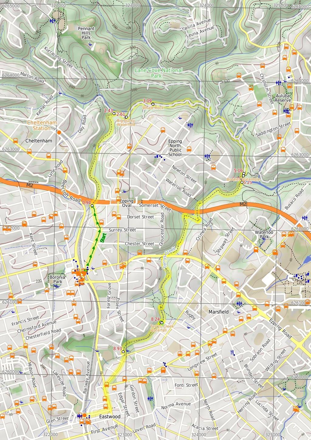
1 Epping to Eastwood Station (via Lane Cove River) hrs 45 mins 10.2 km One way Moderate track 189m Epping to Eastwood, via Lane Cove River, is the longer route through the bush between the stations. This walk visits Big Ducky Waterhole, Whale Rock, Browns Waterhole and the Lane Cove River. The water is a great feature of this walk as you explore the valleys between Epping and Eastwood Stations. 94m 0m Lane Cove National Park Maps, text & images are copyright wildwalks.com Thanks to OSM, NASA and others for data used to generate some map layers.

2 Big Ducky Waterhole Before You walk The servicetrail loops around the top of the Big Ducky waterhole and there is a nice rock overhang in which to break. Is also a popular bird watching area. Unfortunately, recently there has been large quantities of rubbish in the area. (If going down to the waterhole please consider carrying out some of the rubbish if every walker carrys out a bit it will make a difference) Bushwalking is fun and a wonderful way to enjoy our natural places. Sometimes things go bad, with a bit of planning you can increase your chance of having an ejoyable and safer walk. Before setting off on your walk check Whale Rock This is a large boulder that looks eerily like a whale, complete with eye socket. It is a good place to break and climb around the Rock. 1) Weather Forecast (BOM Metropolitan District) 2) Fire Dangers (Greater Sydney Region, unknown) ) Park Alerts (Lane Cove National Park) 4) Research the walk to check your party has the skills, fitness and equipment required 5) Agree to stay as a group and not leave anyone to walk solo Browns Waterhole Think before you TREK Browns Waterhole is a wide, shallow section of the Lane Cove River, downstream of a concrete weir. There is a concrete shared cycle/footpath crossing over the top of the weir, linking Kissing Point Road, South Turramurra to Vimiera Rd, Macquarie Park. On the western side of the waterhole, there is a picnic table and small clearing with a view over this section of the river. The 'Think before you TREK' program developed by NSW Police & NPWS promotes the benefits of planning ahead for your bushwalking trip by using an easy to remember acronym: Terrys Creek Waterfall This is a small waterfall on Terrys Creek, and makes a good spot to break from the walk. adequate supplies of food, water, navigation and first T Take aid equipment. your planned route and tell friends and family when R Register you expect to return. beacon (PLB's) should be carried on walks with E Emergency significant gaps in mobile coverage (check terrain profile). to your planned route and follow the map and walking K Keep trails. Topo Maps The maps provided on wildwalks are helpful, but there are times where you may need maps covering a broader area. Maps that cover this walk include; 1: Map Series:910N PARRAMATTA RIVER 1: Map Series:910 SYDNEY Grade This walk has been graded using the AS The overall grade of the walk is dertermined by the highest classification along the whole track. Grade /6 Moderate track Length 10.2 km One way Time hrs 45 mins Quality of track Formed track, with some branches and other obstacles (/6) Signs Directional signs along the way (/6) Experience Required Some bushwalking experience recommended (/6) Weather Storms may impact on navigation and safety (/6) Infrastructure Limited facilities, not all cliffs are fenced (/6)
3 Are you ready to have fun? Please ensure you and your group are well prepared and equipped for all possible hazards and delays. Check park closures, weather information and Fire Danger Rating before setting out. Optional side trips and alternate routes noted are not included in this walks overall grade, length or time estimate. Please allow extra time for resting and exploring areas of interest. The authors, staff and owners of wildwalks take care in preparing this information but will not accept responsibility for any inconvenience, loss or injury you may experience. Please take care, have fun - Happy Walking. Getting there You can get to Epping Station (gps: , ) by car, train or bus. Car: There is free parking available. You can get back from Eastwood Railway Station (gps: , ) by car or bus. Car: There is free parking available. Find up to date and more information inlcuding; travel directions, weather, park closures and walker feedback at 0 Epping Station (940 m 18 mins) The walk exits Epping Station on the Oxford St side. The walk then crosses Cambridge St and continues down Oxford St. The walk follows the footpath past the shops down Oxford St passing Chester St, Surrey St. Just after Surry St the walk turns left onto Derby St to the end. Nearing the end of Derby St the walk tends left around the yellow gate and onto the concrete driveway which veers left off the road. The walk continues towards the tunnel to come to an intersection just before the tunnel entrance Int of Derby street service trail (1.5 km 25 mins) Veer right: From the intersection this walk follows the Great North Walk arrow up the couple of steps then down along the footpath through the tunnel under the M2 (keeping the creek and wider management trail to your left). Out of the tunnel this walk follows the track as it winds up and around the fenced sewage vent and then continues through the dense bushland in the gully passing a sign marking the entrance to Lane Cove National Park. A little while later the track leads to a signposted intersection with the 'Belinda Crs' management trail. Turn left: From the intersection the track follows the Whale Rock sign down the service trail which narrows into a bushtrack and follows Devlin creek through the gully all the way along until it widens out into a rocky service trail again and comes to the intersection of the Cheltenham service trail. 2.4 Int of Epping Trk and Malton Rd Trail (190 m mins) Continue straight: From the intersection the track follows the Lane Cove River arrow along the servicetrail for a while before it loops around the top of Big Ducky Waterhole Big Ducky Waterhole The servicetrail loops around the top of the Big Ducky waterhole and there is a nice rock overhang in which to break. Is also a popular bird watching area. Unfortunately, recently there has been large quantities of rubbish in the area. (If going down to the waterhole please consider carrying out some of the rubbish if every walker carrys out a bit it will make a difference) 2.61 Big Ducky Waterhole (480 m 8 mins) Continue straight: From the top of Big Ducky Waterhole the continues through the valley keeping Devlins Creek below on the left of the track all the way to Whale Rock..09 Whale Rock This is a large boulder that looks eerily like a whale, complete with eye socket. It is a good place to break and climb around the Rock..09 Whale Rock (2.1 km 40 mins) Continue straight: From Whale Rock the track follows the Penant Hills Park arrow along the service trail as it winds through the valley, crossing several small concrete creek crossings until it comes to the signposted intersection of the Pennant Hills ovals service trail. Continue straight: From the intersection the track follows the Thornleigh via Great North Walk arrow down the short but steep hill and across the river at the causeway. On the other side of the river the track comes up to the intersection of the Great North Walk service trail. Veer right: From the intersection, this walk follows the 'Lane Cove River Park' sign, gently uphill along the management trail, keeping the river to your right. After about 80m, the trail leads to a Y-intersection with sealed management trail (on the left), marked with a STEP Track map/sign. Veer right: From the intersection, this walk follows the 'The Great North Walk' sign along the mostly flat management trail, initially keeping the sealed 'Canoon Rd' trail up to your left. The trail undulates through the tall forest and valley (weedy in places), keeping the river to your right, for just shy of 600m to come to an intersection marked with a 'STEP track' sign (on your left). Continue straight: From the intersection, this walk follows GNW arrow post down the short, fairly steep hill, following the management trail over a small culverted creek. The walk then heads gently uphill for about 0m to come to a clear three-way intersection, marked with a GNW arrow post. Veer right: From the intersection, this walk follows the GNW arrow post south-east, gently up along the wide trail, keeping the main valley to your right. The trail leads gently up through the valley for about 400m, then under some high tension power lines, where there is a mostly clear view over the river (to your right). Here the trail continues for another 80m to come to an intersection with a wide concrete path (just past the 'Caution' sign), beside the Lane Cove River crossing (on your right), marked with a 'The Great North Walk' sign Browns Waterhole int (90 m 2 mins) Veer right: From the intersection, this walk crosses the the causeway of Browns Waterhole. (Caution is needed during and after rain, may become impassable) From here the track continues up the hill on the other side until reaching a small picnic area signposted as 'Browns Waterhole' Browns Waterhole Browns Waterhole is a wide, shallow section of the Lane Cove River, downstream of a concrete weir. There is a concrete shared cycle/footpath crossing over the top of the weir, linking Kissing Point Road, South Turramurra to Vimiera Rd, Macquarie Park. On the western side of the waterhole, there is a picnic table and small clearing with a view over this section of the river Browns Waterhole (40 m 1 mins) Continue straight: From Browns Waterhole, at the picnic tables, this walk follows the concrete management trail away from the river, up the gentle hill until reaching the large green 'Terrys Creek Walking Track' sign Int of Terry's Creek Walking Track and Brown's Wat (2.9 km 55 mins) Turn right: From the intersection the track follows the Terrys creek walking track sign through the dense bush and along a metal walkway the winds along for a little while, joining back onto a bushtrack and following it up some wooden steps and all the way along to the signposted intersection of a bushtrack heading down across the creek. Continue straight: From the intersection the track follows the bushtrack south through the bush winding up some steps and crossing underneath the M2 moter way and back down and around to the signposted intersection of the Crimea road and Epping road tracks. Turn right: From the intersection the tack follows the Epping road arrow down across the creek and up the other side to the signposted intersection of the Eastwood Station track at the number 18 plaque Turn right: From the intersection the track follows the Eastwood Station arrow through the bush winding all the way along to a rock platform where you can see the M2 motorway and continues along the track, all the way through until it comes to the signposted intersection of the signposted intersection of the Eastwood Station track Continue straight: From the intersection the track heads west through the bush winding down a gentle hill and around a sewage access point, coming back up the other side to the signposted intersection of the Eastwood Station track. Turn left: From the intersection the track heads south, up the short hill and through the bush passing 2 sewage access points as it winds along the left hand side of the creek, all the way to the intersection of the Eastwood Station track, a short distance after passing the rd sewage access point. Continue straight: From the intersection the track follows the bushtrack south alongside the creek, passing a sewage access point and continuing up a short hill to the intersection of the unnamed bushtrack. Veer left: From the intersection the track heads south west along the bushtrack winding up and down along the left side of the creek until it crosses a small wooden bridge and continues through the bush, all the way to the intersection of the unnamed bushtrack. Continue straight: From the intersection the track follows the Eastwood Station arrow along the creek and through the bush past signpost 15, and a sewage access point. continuing up a short hill to the intersection of the Epping road track. Continue straight: From the intersection the track follows the bushtrack down the gentle hill, winding around and under the Epping road bridge and across the rocks until it comes to the intersection of the Pembroke road path and the Eastwood Station track at the base of the wooden steps. Veer left: From the intersection the track heads up the steps to the top, at the intersection of the Rest area track. Turn right: From the intersection the track follows the Eastwood Station sign south along the bushtrack winding past a sewage access point and the number 12 signpost, coming down and along the creek, all the way to the intersection of the Eastwood station tracks. Continue straight: From the intersection the track heads south along the bushtrack climbing up a small hill and down across a thin wooden creek bridge, passing a sewage access point as the track continues along the creek for a short while until it turns up and away from the creek, winding up a rocky hill and along the side of the valley for a short while, coming back down towards the creek, passing the number 11 signpost and crossing the creek again. From the creek crossing the track continues up and along the gentle hill winding through the bush until it comes to the signposted intersection of Eastwood station and Pembroke park tracks. Turn right: From the intersection the track follows the Dence Park sign down across the creek (for safety reasons you should avoid the crossing after recent rainfall) and up the other side to the intersection of the Eastwood station and Dence Park tracks. Turn left : From the intersection the track follows the Eastwood station arrow south through the bush winding along side the creek and through a thick patch of bamboo. Staying close to the creek, the track continues upstream until it comes to the unsignposted intersection of the Eastwood station and waterfall tracks. Turn right: From the intersection the track follows the bushtrack heading up the hill through dense ferns and along the side of the valley for a short distance to the intersection of the waterfall loop track Optional sidetrip to Terrys Creek Waterfall (0 m 1 mins) Veer left: From the intersection the track follows the bushtrack

4 heading down towards the creek, winding around and down some rock steps to the intersection of the Terrys creek waterfall. At the end of this side trip, retrace your steps back to the main walk then Turn left Terrys Creek Waterfall This is a small waterfall on Terrys Creek, and makes a good spot to break from the walk Int of Eastwood station and waterfall loop tracks (690 m 1 mins) Veer right: From the intersection the track follows the bushtrack heading up a short rocky hill and through some grass trees, coming down the other side and around beside a short rock wall to the top of the Terrys creek waterfall. Continue straight: From the top of the falls the track follows the creek up stream along the bushtrack winding through the fairly open bush for a while until it heads up some wooden steps onto a platform and continues along all the way through thicker bush, crossing the bridged Terrys creek and continuing all the way along to the back of Forrester park. 8.9 Forrester Park (1. km 2 mins) Veer left: From Forrester Park, this walk heads south-east along Davis Avenue for about 0m to the right-hand bend in the road. From here, the walk crosses Terry's Creek on a bridge and then turns right onto Vimiera Road. At the end of Vimiera Rd, the walk turns right onto Balaclava Rd, then immediately left onto Blaxland Road. The walk passes May St and Ethel Lane, and turns right into Ethel Street, following this road to the end where it comes to Eastwood Railway Station.
5
6 Summary navigation sheet for the Epping to Eastwood Station (via Lane Cove River) km Up/Dwn Length Initial directions (Use full tracknotes and maps for more detail) Start Epping Station , (GR Parramatta River, ) 0.94 Int of Derby street service trail , (GR Parramatta River, 22562) m 18 mins 1.5 km 25 mins The walk exits Epping Station on the Oxford St side. 2.4 Int of Epping Trk and Malton Rd Trail -.754, (GR Parramatta River, 22865) Big Ducky Waterhole -.759, (GR Parramatta River, 22965) Whale Rock , (GR Parramatta River, 267) Browns Waterhole int , (GR Parramatta River, ) Browns Waterhole , (GR Parramatta River, ) Int of Terry's Creek Walking Track and Brown's Waterhole Servicetrail , (GR Parramatta River, ) m mins 480 m 8 mins 2.1 km 40 mins 90 m 2 mins 40 m 1 mins 2.9 km 55 mins Continue straight: From the intersection the track follows the Lane Cove River arrow along the servicetrail for a while before it loops around the top of Big Ducky Waterhole. Continue straight: From the top of Big Ducky Waterhole the continues through the valley keeping Devlins Creek below on the left of the track all the way to Whale Rock. Continue straight: From Whale Rock the track follows the Penant Hills Park arrow along the service trail as it winds through the valley, crossing several small concrete creek crossings until it comes to the signpost... Veer right: From the intersection, this walk crosses the the causeway of Browns Waterhole Int of Eastwood station and waterfall loop tracks , (GR Parramatta River, 25607) 0-0 m 1 mins Optional sidetrip to Terrys Creek Waterfall. Veer left: From the intersection the track follows the bushtrack heading down towards the creek, winding around and down some rock steps to the intersection of the Terrys creek waterfall Int of Eastwood station and waterfall loop tracks , (GR Parramatta River, 25607) Forrester Park , (GR Parramatta River, 2060) m 1 mins 1. km 2 mins Veer right: From the intersection the track follows the bushtrack heading up a short rocky hill and through some grass trees, coming down the other side and around beside a short rock wall to the top of the Terrys c... Veer left: From Forrester Park, this walk heads south-east along Davis Avenue for about 0m to the right-hand bend in the road Powered by TCPDF ( From Veer right: From the intersection this walk follows the Great North Walk arrow up the couple of steps then down along the footpath through the tunnel under the M2 (keeping the creek and wider management trail to you... Continue straight: From Browns Waterhole, at the picnic tables, this walk follows the concrete management trail away from the river, up the gentle hill until reaching the large green 'Terrys Creek Walking Track' sign. Turn right: From the intersection the track follows the Terrys creek walking track sign through the dense bush and along a metal walkway the winds along for a little while, joining back onto a bushtrack and followin...
Epping to Pennant Hills Station (via Lane Cove River)
") Epping to Pennant Hills Station (via Lane Cove River) 3 hrs 5 mins 8.4 km One way Hard track 249m This walk, from Epping to Pennant Hills Station, is a great way to see the upper Lane Cove River Valley.
Epping to Pennant Hills Station (via Lane Cove River) 3 hrs 5 mins 8.4 km One way Hard track 249m This walk, from Epping to Pennant Hills Station, is a great way to see the upper Lane Cove River Valley.
Epping to Gordon Station
 Epping to Gordon Station 4 hrs 15 mins 11.7 km One way Hard track 4 365m This walk, from Epping Station to Gordon Station, passes below the homes which sit on the hills high above the Lane Cove River.
Hunters Hill to Epping Road
 Hunters Hill to Epping Road 2 hrs 30 mins 5.5 km One way Moderate track 154m An enjoyable walk through lower sections of the Lane Cove National Park, this walk features plenty of mangroves next to the
Little Digger Track. 68m. 1 Hr 2.2 km One way. Moderate track 93m. Moores Creek Reserve
 Little Digger Track Hr 2.2 km One way Moderate track 93m This walk follows Moores Creek through several reserves in east Roseville and East Lindfield. The track is named after Australia's 7th Prime Minster,
Currie Rd to Davidson Park
 Currie Rd to Davidson Park 3 hrs 7.2 km One way Moderate track 28m Starting at Currie Rd in Forestville, this walk follows Middle Harbour to Davidson Park, under Roseville Bridge. There are two optional
De Burgs Bridge to Thornleigh station
 De Burgs Bridge to Thornleigh station 3 hrs 45 mins 9.7 km One way Hard track 4 363m This walk follows a section of the Great North Walk, starting from De Burghs bridge. The walk winds north west, through
Heathcote to Engadine via Audley
 Heathcote to Engadine via Audley 6 hrs 3 mins 5 km One way Hard track 4 635m Covering a large section of central Royal National Park, this walk goes through the heath and scrub along a well managed and
Hornsby Blue Gum Walk
 Hornsby Blue Gum Walk 3 hrs Hard track 6.7 km Circuit 4 374m This delightful loop is one of the prettiest and most popular walks in the Hornsby area. Going from an environment of ferns and clear bushland
Waterfall to Heathcote
 Waterfall to Heathcote 5 hrs Hard track 10.8 km One way 4 467m This walk explores the heart of Heathcote National Park, and is easily accessed with a train station at either end. Although relatively close
Wentworth Falls Conservation Hut Loop
 Wentworth Falls Conservation Hut Loop 3 hrs Hard track 6.7 km Circuit 4 341m This scenic walk from Wentworth Falls Station, winds along the Nature Trail to Conservation Hut, then drops into the magnificent
Govetts Leap Loop. 1065m. 909m Blue Mountains National Park. 4 hrs 30 mins 8.7 km Circuit. Hard track 380m
 Govetts Leap Loop 4 hrs 30 mins 8.7 km Circuit Hard track 380m This walk, from Blackheath Train Station, is a fantastic way to see some of the iconic areas of the Blue Mountains in the Blackheath area.
Morgans Creek to Padstow
 Morgans Creek to Padstow 2 hrs 45 mins 8 km One way Moderate track 3 144m This pleasant walk starts from the Morgans Creek park, at Henry Lawsons Drive, and follows the Georges River past the Boomerang
Echo Point to Leura Forest via Three Sisters and Giant Stairs loop
 Echo Point to Leura Forest via Three Sisters and Giant Stairs loop 3 hrs 3.8 km Circuit Hard track 512m This walk starts from the popular Echo Point, in Katoomba, and winds down to the base of the Three
Rail to River Walk. 3 hrs. Hard track 7.5 km Circuit. 222m
 Rail to River Walk 3 hrs Hard track 7.5 km Circuit 4 222m This walk is a great one from Chatswood Station to the Lane Cove River National Park. The walk descends through the vegetated bushland which fills
Popes Glen, Pulpit Rock, Govetts Leap and Braeside Walk
 Popes Glen, Pulpit Rock, Govetts Leap and Braeside Walk 8 hrs Hard track 13.6 km Circuit 4 1068m This large circuit walk, from Popes Glen to Pulpit Rock, Govetts leap and along the Braeside Track, passes
Katoomba Falls Circuit
 Katoomba Falls Circuit hr 5 mins.5 km Circuit Hard track 59m For those looking for a walk involving more than simple boardwalk, this trail winding through the temperate rain forest could be just the thing.
Little Digger Track to Davidson Reserve and Lyrebird Circuit
 Little Digger Track to Davidson Reserve and Lyrebird Circuit 4 hrs 3 mins 11.5 km One way Hard track 4 47m Exploring both the eastern and western sides of Middle Harbour Creek, this walk follows the Little
Carrington Park to Leura Forest and pass loop
 Carrington Park to Leura Forest and pass loop 3 hrs Hard track 4.8 km Circuit 4 674m This walk is a fantastic way to see Leura Forest. The walk descends from Carrington Park, visiting Leura Forest and
Sid Pulsford Walk. 175m. 33m. 1 hr 45 mins 4.1 km One way. Hard track 118m. Gosford LGA
 Sid Pulsford Walk 1 hr 5 mins.1 km One way Hard track 118m Sid Pulsford Walk explores the ridge top of Kincumber Mountain, from Honeman's Rock to Green Point. The walk mostly follows wide management trails.
Rail to River and Stringybark Creek Reserve Walk
 Rail to River and Stringybark Creek Reserve Walk 4 hrs Hard track 11.2 km Circuit 4 302m This walk begins in the busy city of Chatswood and soon enters the nearby bushland around the Lane Cove River. The
Wattamolla to Big Marley Beach
 Wattamolla to Big Marley Beach 4 hrs 10.4 km Circuit Moderate track 4m This walk is an excellent loop which takes in both the coast and the heathy inland of Royal National Park. Nearly the whole walk has
The Foreshore Walk. 24m. 1m Lake Macquarie LGA. 1 hr 15 mins 2.9 km One way. Hard track 81m
 The Foreshore Walk 1 hr 15 mins 2.9 km One way Hard track 81m This walk traverses the coastline of the Green Point reserve. By following a variety of tracks and occasionally traveling inland through eucalyptus
De Burghs Bridge to Fullers Bridge
 De Burghs Bridge to Fullers Bridge 2 hrs 3 mins Hard track 6 km One way 2m 4 Following the Lane Cove River, this walk mostly follows a section of the Great North Walk and is well maintained and signposted.
Scenic World to Echo Point
 Scenic World to Echo Point 1 hr 15 mins 2.1 km One way Moderate track 192m This is one of the most popular tourist walks in the Katoomba area. The walk follows the cliffs along a well maintained and signposted
Teralba to Charlestown Park track head
 Teralba to Charlestown Park track head 4 hrs 30 mins 13.3 km One way Moderate track 3 220m This section of the Great North Walk starts from the Teralba train station and winds down and around the edge
Dead Horse Gap Loop track
 Dead Horse Gap Loop track 4 hrs 30 mins Hard track 9.8 km Circuit 144m 4 This walk starts with a ride up the Kosciuszko Express Chairlift. There is an opportunity to eat at Australia's highest restaurant,
Campbell Drive to Snapper Point
 Campbell Drive to Snapper Point 1 hr 45 mins 4.2 km One way Experienced only 135m This walk follows the Coast Track to Frazer Beach, along the Geebung and (overgrown) Grass Tree Tracks. From the northern
Wallarah Coastal Walk
 Wallarah Coastal Walk 3 hrs 8.3 km Return Hard track 247m This walk starts at Caves Beach and travels south along the coastline, until reaching the Pinney s Headland Lookout. There are many opportunities
Chatswood to Epping Station
 Chatswood to Epping Station 6 hrs Hard track 16.3 km One way 4 533m This walk, from Chatswood to Epping, is a long but enjoyable walk along the Lane Cove valley. The walk mostly follows the Lane Cove River
Balmoral Beach to The Spit
 Balmoral Beach to The Spit 2 hrs 30 mins.3 km One way Hard track 85m This walks follows the coast from Balmoral to the Spit and across Spit Bridge. There are some alternate tracks to consider at high-tides,
Middle Harbour Creek Loop
 Middle Harbour Creek Loop 5 hrs 45 mins 15.1 km Circuit Experienced only 5 570m This walk explores the upper reaches of Middle Harbour Creek, starting and ending at the great parklands at Davidson Park,
The Basin Track and Mackerel Track
 The Basin Track and Mackerel Track 3 hrs 5.9 km Circuit Hard track 226m This walk is a great way to see some popular areas in Ku-ring-gai Chase National Park. The walk from West Head Rd travels to The
Sphinx, Warrimoo and Bobbin Head tracks
 Sphinx, Warrimoo and Bobbin Head tracks 4 hrs 9.6 km Circuit Moderate track 499m This great walk starts at the Sphinx Memorial and loops around via Cowan Creek, exploring diverse environments as it changes
Callicoma Loop. 174m. 98m. 2 hrs. Hard track 5.1 km Circuit. 153m
 Callicoma Loop 2 hrs Hard track 5.1 km Circuit 153m This great circuit walk passes through some really nice forest around the fringe of Cherrybrook. Highlights of the walk include some beautiful rock overhangs
Mackerel Beach, West Head Loop
 Mackerel Beach, West Head Loop 5 hrs 8.6 km Circuit Hard track 422m The Mackerel Beach, West Head Loop is a walk which explores a large part of the West Head. The journey starts and finishes with a ferry
Berowra to Mt Kuring-gai
 Berowra to Mt Kuring-gai 4 hrs 30 mins 9.4 km One way Hard track 4 551m From the ridges above Cowan Creek, this walk takes in some great lookouts (especially around Mt Kuringgai) as well as enjoying an
Mackerel Beach and Resolute Loop
 Mackerel Beach and Resolute Loop 3 hrs 5.4 km Circuit Hard track 384m This walk is another great walk in Ku-ring-gai Chase National Park, accessed by ferry. From the Mackerel Beach wharf, this walk uses
Woolwich Wharf to Boronia Park
 Woolwich Wharf to Boronia Park 2 hrs 5.8 km One way Moderate track 175m Going through the streets of Hunters Hill, this walk is on the first segment of the Great North Walk. The majority of the walk is
Roseville to Macquarie Park
 Roseville to Macquarie Park 3 hrs 3 mins 8.8 km One way Hard track 4 29m This walk starts at Roseville station and explores the streets and alleyways of Roseville before joining the main spine of the Great
Under and Over Cliff Walk
 Under and Over Cliff Walk 4 hrs 9.4 km Circuit Moderate track 576m This walk from Wentworth Falls Station is a fantastic way to see a large majority of the Wentworth Falls cliffline. The track winds under
Patonga to Woy Woy. 5 hrs 45 mins 15.5 km One way. Hard track. 497m
 Patonga to Woy Woy 5 hrs 45 mins 15.5 km One way Hard track 4 497m This walk explores a variety of environments from the shore line and coastal cliffs near Patonga, to the dry, rocky and open ridge line.
Wentworth Falls Station Loop (Undercliff Walk)
") Wentworth Falls Station Loop (Undercliff Walk) 4 hrs 3 mins Hard track 8.9 km Circuit 658m 4 This walk passes some stunning waterfalls and views into the Jamison Valley, following the cliff edges around
Wentworth Falls Station Loop (Undercliff Walk) 4 hrs 3 mins Hard track 8.9 km Circuit 658m 4 This walk passes some stunning waterfalls and views into the Jamison Valley, following the cliff edges around
Spit Bridge to Middle Head Forts
 Spit Bridge to Middle Head Forts 2 hrs 30 mins 6.3 km One way Hard track 4 181m This scenic walk takes you from the Spit Bridge, along the coast to explore the Middle Head Forts. There are a few alternate
National Pass from Wentworth Falls to Conservation Hut
 National Pass from Wentworth Falls to Conservation Hut 3 hrs Hard track 3.6 km One way 739m Starting at Wentworth Falls picnic area, this scenic and historic walk explores many waterfalls, lookouts and
Green Point Circuit Walk
 Green Point Circuit Walk 3 hrs 7.7 km Circuit Hard track 269m This walk visits all of the popular locations in Green Point Reserve, as well as some of the lesser-visited areas inland. Taking in Sea Eagle
Bouddi Coastal Walk. 5 hrs. Hard track 8.1 km One way. 364m
 Bouddi Coastal Walk 5 hrs Hard track 8.1 km One way 4 364m This is one of the longer walks in the Bouddi National Park and it is rich in scenery. The walk follows the coastline with many side trips to
Blackheath Station to Junction Rock Loop (via Grand Canyon and Popes
 Blackheath Station to Junction Rock Loop (via Grand Canyon and Popes 8 hrs 30 mins 18.2 km Circuit Hard track 4 1254m This circuit starts in Blackheath and heads down into the Grand Canyon and Rodriguez
Upper Rumbalara circuit
 Upper Rumbalara circuit 1 hr 30 mins 3.3 km Circuit Hard track 176m A great circuit walk, covering most of the walking tracks and sights in the upper section of the Rumbalara Reserve. There is some really
Thornleigh to Hornsby
 Thornleigh to Hornsby 4 hrs Hard track 10.2 km One way 4 526m Starting at Thornleigh station you walk through suburban streets for a short while before diving into the bush at the southern end of Berowra
Dubbo Gully and Ten Mile Hollow Circuit (via Clares Bridge)
") Dubbo Gully and Ten Mile Hollow Circuit (via Clares Bridge) 2 Days Hard track 24.3 km Circuit 4 1117m This two day (or ten hour) walk follows several historic roads, now closed to traffic. Starting with
Dubbo Gully and Ten Mile Hollow Circuit (via Clares Bridge) 2 Days Hard track 24.3 km Circuit 4 1117m This two day (or ten hour) walk follows several historic roads, now closed to traffic. Starting with
Lane Cove Tourist Park River Circuit
 Lane Cove Tourist Park River Circuit 5 hrs 12 km Circuit Hard track 383m This walk follows a large section of Lane Cove River. The walk follows the Riverside Walking track up the Lane Cove River to De
Gordon to Chatswood Station
 Gordon to Chatswood Station 4 hrs 30 mins 12.2 km One way Hard track 4 381m This walk is a great way to get into the bush without being far from civilisation. The walk wanders through untouched valleys
Taronga Wharf to Chowder Bay
 Taronga Wharf to Chowder Bay 2 hrs 4.4 km One way Moderate track 246m Starting at Taronga Wharf, this walk passes many icons of Sydney, including Taronga Zoo, HMAS Sydney Mast, Chowder Bay. The walk also
Wentworth Falls Station Loop
 Wentworth Falls Station Loop 5 hrs 3 mins 9.5 km Circuit Hard track 4 13m The Wentworth Falls Station Loop takes in most of the upper tracks around Wentworth Falls. There are many scenic views near the
Glenbrook and Euroka Circuit
 Glenbrook and Euroka Circuit 2 Days 16.6 km Circuit Experienced only 790m This two day circuit, returning to Glenbrook Station, is a scenic walk which passes many of the tourist attractions within the
Federal Pass Walking Track
 Federal Pass Walking Track 5 hrs Hard track 8 km One way 4 989m This classic trail follows along the base of the cliffs from Leura to the Golden Stairs, passing many of the more popular sights of the Katoomba
North Ryde Fairyland circuit
 North Ryde Fairyland circuit 2 hrs 30 mins Hard track 6.9 km Circuit 193m 4 Starting at North Ryde train station this walk explores a stretch of the Lane Cove River, visiting the historic Fairlylands Pleasure
Echo Point to Leura Forest Circuit
 Echo Point to Leura Forest Circuit 3 hrs 4.8 km Circuit Hard track 588m Forming a circuit around the cliffs and then the valley floor, this is a walk more then capable of convincing a walker of the beauty
Wentworth Falls Loop. 893m. 665m. 6 hrs 10.2 km Circuit. Hard track 1093m. Blue Mountains National Park
 Wentworth Falls Loop 6 hrs 1.2 km Circuit Hard track 193m This is a great walk, both in size and spectacular views. The walk makes its way from Wentworth Falls train station and drops off the plateau,
Faulconbridge to Blaxland
 Faulconbridge to Blaxland 2 Days Experienced only 15.2 km One way 5 693m This two-day walk, or very solid one-day walk, takes you from station to station, through lush, scenic forest in the lower Blue
Sphinx to Mt Kuring-gai
 Sphinx to Mt Kuring-gai 4 hrs 45 mins 1.7 km One way Hard track 673m This walk starts at the Sphinx War Memorial and follows some well maintained and popular walking tracks down to Cowan Creek. Enjoy the
Spit Bridge to Manly (Manly Scenic Walkway)
") Spit Bridge to Manly (Manly Scenic Walkway) 3 hrs 45 mins 9.1 km One way Moderate track 349m The Spit to Manly walk is a classic bushwalk on Sydney's Northern Beaches. The walk follows a well-maintained
Spit Bridge to Manly (Manly Scenic Walkway) 3 hrs 45 mins 9.1 km One way Moderate track 349m The Spit to Manly walk is a classic bushwalk on Sydney's Northern Beaches. The walk follows a well-maintained
Hermitage Foreshore Track
 Hermitage Foreshore Track 1 Hr 2.2 km One way Moderate track 123m The Hermitage Foreshore Walk is a wonderful way to explore Sydney Harbour from the perspective of South Head. This walk starts from Nielsen
Bobbin Head Loop. 166m. 0m Ku-ring-gai Chase National Park. 5 hrs 12.9 km Circuit. Hard track 619m
 Bobbin Head Loop 5 hrs 12.9 km Circuit Hard track 619m This great circuit walk enjoys a variety of landscapes in Ku-ring-gai Chase National Park. The walk starts at the historic Sphinx war memorial and
Scenic world to Three Sisters Loop via Furber Steps
 Scenic world to Three Sisters Loop via Furber Steps 5 hrs 5.8 km Circuit Hard track 722m This walk starts from the popular Scenic World, in Katoomba, and winds down the Furber steps into the Jamison Valley,
Cape Banks Circuit. 50m. 2m Botany Bay National Park. 3 hrs 7.3 km Circuit. Hard track 190m
 Cape Banks Circuit 3 hrs 7.3 km Circuit Hard track 19m This Cape Banks Circuit has a lot to offer and is thoroughly recommended. The walking travels over beaches, through coastal forest and across exposed
Charlestown Park trackhead to Newcastle station
 Charlestown Park trackhead to Newcastle station 5 hrs 30 mins 12.1 km One way Hard track 4 287m This section of the Great North Walk starts from the Charleston Park track head and winds through the streets
Rumbalara Explorer. 158m. 5m Rumbalara Reserve. 2 hrs 45 mins 6.1 km Circuit. Hard track 326m
 Rumbalara Explorer 2 hrs 5 mins 6.1 km Circuit Hard track 326m Pretty well the grand tour of the Rumbalara Reserve, this walk takes in much of the great scenery the reserve has to offer. The walk covers
The Coast Track. 2 Days. Hard track 27.4 km One way. 1351m
 The Coast Track 2 Days Hard track 27.4 km One way 4 1351m Heading south, this walk covers the coastline of the Royal National Park and can truly only be described as amazing. With breathtaking coastal
Gosford to Lisarow. 202m
 Gosford to Lisarow 4 hrs 3 mins Hard track 11.3 km One way 4 479m This walk is a great way to explore the ridge-top bushland between Gosford and Lisarow. Passing through Rumbalara and Katandra Reserves,
Manly to Seaforth Oval
 Manly to Seaforth Oval 5 hrs 45 mins 13.7 km One way Moderate track 3 624m This walk follows the Manly to Spit Scenic Walkway, then continues past The Spit Bridge to Seaforth Oval. The walk provides magnificent
Bouddi Ridge and Coastal Walk
 Bouddi Ridge and Coastal Walk 2 Days Hard track 27 km Circuit 4 126m This overnight walk takes in the majority of the magnificent Bouddi National Park. The walk starts from the pleasant Putty Beach camping
Taronga Zoo to Spit Bridge
 Taronga Zoo to Spit Bridge 5 hrs Hard track 1.4 km One way 4 41m This is a scenic and culturally rich walk with views over Sydney Harbour and many interesting heritage buildings along the way. The start
Six Foot Track. 1212m
 Six Foot Track 3 Days 44.8 km One way Hard track 4 2066m This classic walk takes you from Katoomba to Jenolan Caves via a historic horse route. The walk travels mainly along well-maintained service tracks
Narrabeen Lagoon Trail (from Middle Creek)
") Narrabeen Lagoon Trail (from Middle Creek) 2 hrs 30 mins 8.6 km Circuit Very easy 1 105m The Narrabeen Lagoon Trail is a wonderful and accessible walk on the Northern Beaches of Sydney. The trail is used
Narrabeen Lagoon Trail (from Middle Creek) 2 hrs 30 mins 8.6 km Circuit Very easy 1 105m The Narrabeen Lagoon Trail is a wonderful and accessible walk on the Northern Beaches of Sydney. The trail is used
Sydney to Thornleigh via Lane Cove Tourist Park
 Sydney to Thornleigh via Lane Cove Tourist Park 2 Days 33 km One way Hard track 4 1114m This overnight walk starts from the Obelisk in Macquarie Park, Sydney, at the official start of the Great North Walk.
Light to Light Walk 2 days
 Light to Light Walk 2 days 2 Days Hard track 3.9 km One way 4 794m Over two days, this classic walk explores the coast from Boyd Tower to the Green Cape Lighthouse in the south. Hegartys Bay Camp is over
Detailed maps, and portaging and camping information follow.
 Overview of Bain route. The launch site is at Davidson Lake, just before the Manitoba/Ontario border. You can do a loop if you leave a vehicle at Tulabi Lake (at the canoe route parking lot). The road
Hammer Vale and Linchmere Common
 point your feet on a new path Hammer Vale and Linchmere Common Distance: 9 km=5½ miles or 6 km=3¾ miles easy walking with one steep section Region: Hampshire, West Sussex Author: Botafuego Refreshments:
Harbour Bridge to Taronga Zoo
 Harbour Bridge to Taronga Zoo 4 hrs 9.8 km One way Moderate track 389m On this walk, you will explore much of the foreshore linking Milsons Point Station to Taronga Zoo Ferry wharf. The walk is mostly
RILLINGTON TO MALTON by Tania Dickinson
 RILLINGTON TO MALTON by Tania Dickinson This walk takes you from the Vale of Pickering up on to the Wold scarp, before dropping down again through the pretty village of Settrington and joining the Centenary
VERN S CAMP from Minginui
 VERN S CAMP from Minginui Map: Kuratau, 1:50,000 V18 Refer Figures 1, 3, 4 and 5 GPS: Geodetic Datum 1949 Refer Figure 10a (Geographic) and 10b (NZ Grid) How to get to START: From the police station on
Beautiful Walks from the Blue Ball Inn
 Walk No. 7 COAST AND VALLEY WALK Countisbury, Glenthorne, County Gate, Brendon, Rockford and Wilsham 10 MILES APPROX. Walking time 5 hours approx. (not including breaks)> OS Sheet 64/74 Lynton and Lynmouth.
Route: Skewsby Foulrice Stearsby
 Route: Skewsby Foulrice Stearsby Distance: 7 miles Map: Explorer: 300 Howardian Hills & Malton Start (OS ref): SE625710 Park in the village of Skewsby. Walk east out of the village to the T-Junction and
Distance: 14 km=8½ miles or 7 km=4½ miles easy-to-moderate walking
 point your feet on a new path Normandy Distance: 14 km=8½ miles or 7 km=4½ miles easy-to-moderate walking Region: Surrey Author: Botafuego Refreshments: Pirbright, Ash date written: 20-feb-2012 date revised:
THE WELLDIGGERS ARMS, HESWORTH AND FITTLEWORTH TRAIL
 THE WELLDIGGERS ARMS, HESWORTH AND FITTLEWORTH TRAIL 5.5 miles Circular 3 hours 041017 Challenging Terrain A 300-year-old pub turned country-inn on the edge of the South Downs National Park, The Welldiggers
Winterfold Wood. point your feet on a new path. In Brief
 point your feet on a new path Winterfold Wood Distance: 8½ km=5¼ miles Region: Surrey Author: Schwebefuss Refreshments: Windmill Inn, Peaslake after the walk moderate walking with many gradients Date written:
ST. AGNES. you cannot put a time limit on beauty.
 ST. AGNES CIRCULAR WALKS AROUND There are many enjoyable and picturesque walks around St. Agnes most are signposted and are featured on the St. Agnes Mini-guide map. Because most of our footpaths are in
Calaveras Big Trees State Park--South Grove Loop
 Copyright 1999 by Jeff Robinson. You are free to use and reproduce this description for personal, not-for-profit, and not-forbusiness use. Any reproduction other than for personal use, including businesses,
A mainly flat walk along the Peak Forest Canal to Castle Hill and returning along the River Tame via Hulmes Wood and Haughton Dale.
 Walk 9 Haughton Green, Peak Forest Canal, Castle Hill, Hulmes Wood, River Tame, Haughton Dale Circular Miles: 3.9 Time: 1 Hour 30 Minutes Grade: Easy To Moderate Starting Point: Junction Of Gibraltar Lane/Newport
VELINDRE VALLEYS WALK FOR STEFFAN
 VELINDRE VALLEYS WALK FOR STEFFAN IMPORTANT INFORMATION FOR WALKERS AND MARSHALS 1 Table of Contents Key Contact Numbers:... 3 Timetable and locations... 4 T-shirts... 4 Important Advice for Walkers...
Harlington - Sharpenhoe - Pulloxhill
 Harlington - Sharpenhoe - Pulloxhill ID: 3676, Distance: 8 miles, Height gain: 140 Metres, Map: Explorer 193 Luton & Stevenage, Contributor: Dennis Jeanes Duration: 3 Hours 27 Mins Features Church,Great
Approximate distance: 10 miles For this walk we ve included OS grid references should you wish to use them. Start. End
 Approximate distance: 10 miles For this walk we ve included OS grid references should you wish to use them. 2 3 Start End 1 N W E S Reproduced by permission of Ordnance Survey on behalf of HMSO. Crown
ULTRA-TRAIL AUSTRALIA May 2018 COURSE DESCRIPTION AND COURSE NOTES
 ULTRA-TRAIL AUSTRALIA 100 19-20 May 2018 COURSE DESCRIPTION AND COURSE NOTES LEG 1 Scenic World (Start) to Narrow Neck (Checkpoint 1) Course Description: From the start, at the front entrance of Scenic
MAPS & WALK NOTES. DAY 2: Greenwich Wharf to Woolwich Wharf
 MAPS & WALK NOTES DAY 2: Greenwich Wharf to Woolwich Wharf Total Distance: 15.5km Time: Approximately 5 hours 30 mins five Sections Walk Notes in Section Name Length Time 2:1 Greenwich Wharf to Northwood
The Mendip Way. Route Directions and Maps Wells to Frome
 The Mendip Way Route Directions and Maps Wells to Frome Website: www.mendiphillsaonb.org.uk Email: mendip@mendiphillsaonb.org.uk Facebook & Twitter: @MendipHillsAONB Phone: 01761462338 1 Wells to Shepton
Dyrham and Hinton Parish Walks
 Dyrham and Hinton Parish Walks A series of five walks in the parish, exploring most of the public footpaths. By John Miller Each walk is described in detail, with a complete map, to provide a handy guide
Poundgate and The Hurstwood
 point your feet on a new path Poundgate and The Hurstwood Distance: 11 km=7 miles Region: East Sussex Author: Stivaletti Refreshments: High Hurstwood easy walking Date written: 24-jul-2016 Last update:
10 Miles Circular 5 hours
 VISIT RYEDALE PICKERING AND CAWTHORN CAMPS 10 Miles Circular 5 hours Moderate Terrain 120616 A 10 mile (16km) there and back walk from the market town of Pickering in Ryedale. The route heads north through
Tideswell to Castleton
 Tideswell to Castleton 1 Walk summary Length: 14 km, 8.5 miles Maps: OS Explorer OL1 The Peak District - Dark Peak Area, OS Explorer OL24 The Peak District - White Peak Area, OS Landranger 110 Sheffield