WHITE STREET/ ENGLISH PLAZA STREETSCAPE IMPROVEMENT PROJECT
|
|
|
- Ross Singleton
- 5 years ago
- Views:
Transcription


1 WHITE STREET/ ENGLISH PLAZA STREETSCAPE IMPROVEMENT PROJECT 1
2 Project Goals 1 Improved Safety: Lighting, Multi-Modal Circulation, Emergency Access, Tripping Hazards; Stormwater 4 Environmental Performance: Landscaping, Shade Trees, Green Infrastructure, & LED Lighting 2 Improved Multi-Modal Access & Parking: All Users, ADA, Loading, Refuse 5 Economic Viability: Increase Foot Traffic, Change Perception, Areas for Public Art, Entertainment, Sales, Events 3 Improved Aesthetics: Lighting, Landscaping, Seating Areas, Pavement & Sidewalk Treatments, Public Art 6 Advance the Goal of making Red Bank a Destination to Work, Live, Dine, & Play 2


3 Balancing Businesses & Residents Importance of Collaboration People Profit Balance Business Vitality, Pedestrian, and Infrastructure Needs Planet 3


4 Borough Administrator Council Committee Chair- DPU Council Committee Chair- Parking DPU Director Fire Marshall/Code Enforcement Parking Utility Stakeholder Interviews Red Bank RiverCenter Visual Improvement & Streetscape Improvement Committees Members of Staff & Board of Trustees Police Chief Business Representatives Resident Representatives Borough Engineer Historic Preservation Commission Environmental Commission Shade Tree Committee 4


5 Listening & Due Diligence Phase Gathering Feedback & Data 24 Stakeholder one-on-one Interviews 3 Meetings with the RBVIC Property Owners Meeting Meeting with JCP&L & Letters to all Utilities and review of data Obtaining Title 5

6 6 Multiple Concepts Considered
7 7 Chosen Alternative

8 8 Vetted Various Amenities
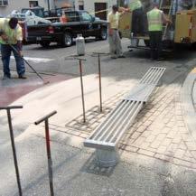
9 Items Added Increase Lighting Items Incorporated from Listening Phase Goal 1: Improved Safety Better Circulation (Car and Pedestrian) More Visible Crosswalks, Stop Bars, and Lane Markings Replace deteriorated sidewalk, curb, and pavement, improve drainage Eliminate angles and blind spots Fix Drains near White Street (liquor Store) Add Bollards to protect Trattoria Add Crosswalk on White Street near English Plaza Restripe loading area/ no parking area More Green Space Loading Zones Stop Bars and Crosswalks Stop Double Parking by extending sidewalk Raise curbs to 6 on White Street to stop k-turns and people driving up on sidewalk Add seating for aging population Bump-outs Hydrant access Will not block overhead fire escapes Roll curbs for Fire Truck turning movements if needed (if necessary based on truck turning templates) Close Alley for better safety Bike Racks Items Borough will Handle with Borough Engineer Mid-Block Crosswalk on W. Front Street Adding drainage on West Front Street to connect the drains at this ingress/egress 9
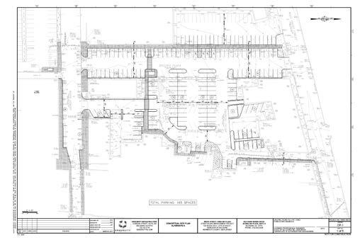
10 Goal 2: Improved Multi-Modal Access & Parking Items Added Increased the # of Parking Stalls by 7 (Increased by 4 in English Plaza and by 3 in the White Street Lot) Can potentially add 4-5 more spaces on White Street if the area in front of prior firehouse and theater is also restriped. Ingress/egress aligned between English Plaza and White St Improved Vehicular Circulation A wide and safe connection Pedestrians from Riverside Gardens to Monmouth Street A location for pedestrians to walk if they wish to not walk in drive aisle Loading zones ADA Stalls and Ramps 10


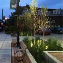


11 Improved Goal Aesthetics, 3: Improved Livability Aesthetics & Economic Vitality Streetscape Elements Street Trees Public Art Lighting ADA Ramps Sidewalk Pavement Pay Station Shelters Street Furniture Curb Extensions Street Fairs 11


12 Improved Goal Aesthetics, 3: Improved Livability Aesthetics & Economic Vitality Lighting & Walls 12


13 Improved Goal Aesthetics, 3: Improved Livability Aesthetics & Economic Vitality Murals 13


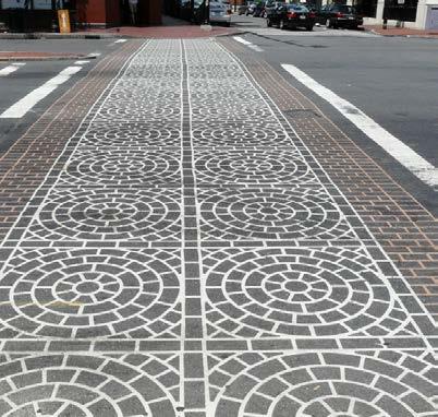
14 Improved Goal Aesthetics, 3: Improved Livability Aesthetics & Economic Vitality Treatments on Narrow Section of White Street 14
15 Goal 3: Improved Aesthetics Items Added Street Furniture Curb Extensions Event Space Brick Walkways Benches Street Trees Aesthetic Lighting Banner Arms Overhead Alley lighting Colored lights (ability for fixtures to change color for events/holidays) Pavement Treatments Items to be included in separate projects Public Sculptures Murals under the Bid Project or separate Program 15
16 Goal 4: Environmental Performance Items Added Reduced Impervious Area More Green space and landscaping Added more Shade Landscaping LED lights Brick Pavers without concrete bed Electric charging stations 16
17 Goal 5: Economic Viability Items Added Encouraged foot traffic for businesses with wide, inviting, aesthetic, and safe brick walkway connection from Riverside Gardens to Monmouth Street Added convenient well circulated parking areas and increased parking Added multiple options for event space Design in a manner that enables businesses to promote back entrances We were requested to look at easement behind the Dublin House (we added brick walkway access to the brick alley by Dublin House) Close White Street from time to time for events (tested at property owners meeting) Addressed sign pollution (will use license plate recognition in liue of numbering stalls) Balanced function and environmental performance to make the area feel safe and inviting Make it a gateway 17
18 Goal 6: Advancing the Goal of Making Red Bank A Destination to Work, Live, Dine, and Play Items Added The entire project accomplishes this Goal Balancing the needs of residents, businesses and environment Honoring the past and looking to the future A community based approach for a project that is embraced by the community 18
19 QUESTIONS THANK YOU 19
Derby Street. Project Updates. Salem, Massachusetts
 Derby Street Project Updates Salem, Massachusetts September 13, 2017 Project Limits Derby Street Project Objectives 1. Improve complete streets elements on Derby Street 2. Improve sidewalks on finger streets
City of Darlington Beautification Report
 City of Darlington Beautification Report Approved by the City of Darlington Beautification Board February 2016 The New Downtown Darlington has seen many changes during the past decade with the rehabilitation
MARTIN LUTHER KING JR. WAY
 OCTOBER 2011 40 Vision and Goals The Martin Luther King, Jr. Way Illustrative Master Plan that follows has been developed through a process of community involvement. It expresses a long term vision for
PUBLIC REALM MASTER PLAN
 WESTSHORE BUSINESS DISTRICT PUBLIC REALM MASTER PLAN MASTER PLAN COMMITTEE MEETING MARCH 20, 2013 WESTSHORE BUSINESS DISTRCT PUBLIC REALM MASTER PLAN MACRO-SCALE CONCEPT: A PUBLIC REALM FRAMEWORK DEFINED
Tonight is for you. Learn everything you can. Share all your ideas.
 Strathcona Neighbourhood Renewal Draft Concept Design Tonight is for you. Learn everything you can. Share all your ideas. What is Neighbourhood Renewal? Creating a design with you for your neighbourhood.
FOCUS AREA 1 - Alberta Avenue Pocket Park 3 (121 Ave and 92 St)
") FOCUS AREA 1 - Alberta Avenue Pocket Park 3 (121 Ave and 92 St) New benches Plant evergreen trees Widen existing sidewalk from 1.5m to 1.8m Marked crosswalk 1.8m wide sidewalk Add pedestrian oriented lights
FOCUS AREA 1 - Alberta Avenue Pocket Park 3 (121 Ave and 92 St) New benches Plant evergreen trees Widen existing sidewalk from 1.5m to 1.8m Marked crosswalk 1.8m wide sidewalk Add pedestrian oriented lights
Bicycle and Pedestrian Advisory Committee (BPAC) November 21, 2013
 November 21, 2013") Bicycle and Pedestrian Advisory Committee (BPAC) November 21, 2013 OVERALL LAND USE CONCEPT Overall Broadway Valdez District: 95.5 acres (35.1 acres right-of ways + 60.4 acres developable land) Plan Subareas:
Bicycle and Pedestrian Advisory Committee (BPAC) November 21, 2013 OVERALL LAND USE CONCEPT Overall Broadway Valdez District: 95.5 acres (35.1 acres right-of ways + 60.4 acres developable land) Plan Subareas:
WELCOME. City of Eden Prairie West 70 th Street
 WELCOME City of Eden Prairie West 70 th Street Project Schedule Sep Oct Nov Dec Jan Feb Mar Apr May Jun Jul Aug >>> May WEST SEGMENT Concept Plan Fall 2014 Plan Development Winter 2014 Summer 2015 Construction
BROOKLAND Multi-Modal Transportation & Streetscape Study* NE Washington, DC
 BROOKLAND Multi-Modal Transportation & Streetscape Study* NE Washington, DC The study s goal is to create a multi-modal transportation and streetscape design plan to increase transportation efficiency,
Fulton Market Streetscape
 Fulton Market Streetscape Ogden Avenue to Halsted Street Public Meeting Recommended Improvements December 10th, 2014 Meeting Purpose and Goals Present Existing Conditions Community Input and Charrette
STREETSCAPE CONCEPT PLAN
 03 STREETSCAPE CONCEPT PLAN Zone 1 This zone includes the gateway into both the downtown and the Village at Harlem. The gateway features are shown closer to the Harlem intersection to make them more prominent.
Executive Summary Route 30 Corridor Master Plan
 Route Corridor Master Plan Project Overview The Route Corridor Master Plan is a coordinated multimodal transportation and land use plan for the entire stretch of Route through East Whiteland Township,
Victoria Park Master Plan
 Victoria Park Master Plan Phase I Presented By: ARCHITECTURAL ALLIANCE & HUGHES HUGHES INC. History of Victoria Park Phase I Purpose Inventory of Existing Conditions Identification of Options by Type (for
Appendix C. TRAFFIC CALMING PROGRAM TOOLBOX
 Appendix C. TRAFFIC CALMING PROGRAM TOOLBOX PHASE I...2 Do Not Enter Sign...3 One-Way Sign...4 Turn Prohibition...5 Pavement Markings...6 Speed Monitoring Trailer...7 Neighborhood Speed Watch...8 Police
Item to be Addressed Checklist Consideration YES NO N/A Required Description Complete Streets Guidelines
 Passaic County Complete Streets Checklist - Concept Development Project Name Item to be Addressed Checklist Consideration YES NO N/A Required Description Complete Streets Guidelines Existing Plans Have
Option W: N. Washington Street Project
 Option W: N. Washington Street Project Location: one block of North Washington Street, between West Broad Street and Park Avenue Description: upgrades to existing lighting new brick sidewalk to replace
Welcome to the Quebec Alternatives Analysis Public Meeting
 Welcome to the Public Meeting Please sign in. Public Comment Please fill out a comment card and tell us what you think. Check back or comment any time at: www.quebecalternatives.com Project Area Technical
Typical Cross Section: DOWNTOWN (Observer Highway - 8th Street)
") Typical Cross Section: DOWNTOWN (Observer Highway - 8th Street) DRAFT SEPTEMBER 23, 14 1 Washington Street Typical Block Downtown Typical Block: DOWNTOWN (Observer Highway - 8th Street) New crosswalks
Typical Cross Section: DOWNTOWN (Observer Highway - 8th Street) DRAFT SEPTEMBER 23, 14 1 Washington Street Typical Block Downtown Typical Block: DOWNTOWN (Observer Highway - 8th Street) New crosswalks
CONNECTIVITY PLAN. Adopted December 5, 2017 City of Virginia Beach
 CONNECTIVITY PLAN Adopted December 5, 2017 City of Virginia Beach CONTENTS 1.0 Background & Purpose... 2 2.0 Existing Inventory & Analysis... 3 ViBe District Existing Walking Conditions... 4 3.0 ViBe District
Streetscape: Core Shopping District
 Streetscape: Core Shopping District DRAFT DRAFT DRAFT May 00 Core Shopping District: Phase Blue Island s Core Shopping District is located along Western Avenue, between Grove and Union Streets. Streetscape
Complete Streets. Designing Streets for Everyone. Sarnia
 Complete Streets Designing Streets for Everyone Sarnia Complete Streets ~ Sarnia ~ 2018 Introduction Our City is made up of a network of streets that we use to go for a walk, cycle to work, drive to the
Elm Street Business District: Streetscape and Signage Plan
 Winnetka Preliminary Streetscape & Signage Village Council Presentation 1 Elm Street Business District: Streetscape and Signage Plan VILLAGE OF WINNETKA DOWNTOWN MASTER PLAN VILLAGE COUNCIL PRESENTATION
York Boulevard Streetscape Master Plan
 York Boulevard Streetscape Master Plan October 24 th, 2008 The Story of York Boulevard Streetscape Master Plan Design. Chapter 126 Dealing with Engineers. 2 1 Today s Presentation Topics: 1. Show the streetscape
Broad Street Bicycle Boulevard Design Guidelines
 Broad Street Bicycle Boulevard Design Guidelines Building from the strategies introduced in the 2013 Bicycle Transportation Plan and community input received thus far, City Transportation Staff have identified
Ocean Park Boulevard Green Street Project Alternatives & Trade Offs
 Planning Commission March 4, 2009 Ocean Park Boulevard Green Street Project Alternatives & Trade Offs Purpose of Tonight s Meeting Review concept plans and options Provide input on alternatives and trade-offs
WHEREAS delivery trucks also pass through the Narrows, into the northern parking lot, to loading docks in the back of the building.
 CEDAR-ISLES-DEAN NEIGHBORHOOD ASSOCIATION ( CIDNA ) RESOLUTION OPPOSING A DRUG STORE DRIVE THRU, AND COMMENDING DORAN COMPANIES FOR PROPOSING MITIGATING AMENITIES INCLUDING NEW LANDSCAPING AND A DEDICATED
Omaha s Complete Streets Policy
 Omaha s Complete Streets Policy (Adopted August 2015) VISION To create great places and enhance our quality of life, the City of Omaha will provide safe, accessible streets for all users. Complete Streets
THE ALAMEDA CONCEPT DESIGN COMMUNITY MEETING 3. A Plan for The Beautiful Way JANUARY 28, 2010
 CONCEPT DESIGN COMMUNITY MEETING 3 JANUARY 28, 2010 AGENDA INTRODUCTION COMMUNITY INPUT ROADWAY STUDIES STREETSCAPE DESIGN STATIONS DISCUSSION SUMMARY AND DISCUSSION NEXT STEPS CLOSE INTRODUCTION SCHEDULE
PRINCE GEORGE S PLAZA METRO AREA PEDESTRIAN PLAN
 PRINCE GEORGE S PLAZA METRO AREA PEDESTRIAN PLAN May 28, 2008 Agenda Welcome and introductions Project overview and issue identification Planning context and strengths Design challenges and initial recommendations
Design Guidelines. Overview. Design Vision for Yellow Brick Road
 Design Guidelines Overview This section presents the design vision for the Yellow Brick Road network. The Yellow Brick Road is envisioned to be an interconnected network of safe and secure roadways where
STEERING COMMITTEE MEETING June 17, Streetscape Overview Burlington Comprehensive Master Plan
 STEERING COMMITTEE MEETING June 17, 2015 Streetscape Overview Burlington Comprehensive Master Plan 1 Introduction Slide This slide show was presented to the Burlington Steering Committee on June 17, 2015
Vision: Traditional hamlet with an attractive business/pedestrian friendly main street connected to adjacent walkable neighborhoods
 N D. Focus Area II Vision: Traditional hamlet with an attractive business/pedestrian friendly main street connected to adjacent walkable neighborhoods Transit Road Focus Area II is located in the Hamlet
Cross Street Corridor Non-Motorized Enhancement Project Project Description
 Cross Street Corridor Non-Motorized Enhancement Project Project Description A cooperative study of the Cross Street neighborhood was completed in May 2002 by the City of Ypsilanti, the Depot Town Downtown
Ballston Station Multimodal Study WMATA and Arlington County. Meeting Minutes
 Date of Meeting: June 10, 2010 Location: Ballston Metrorail Station and NRECA Building 4301 Wilson Blvd, Arlington, VA Subject: Ballston Station Multimodal Study Stakeholder Meeting #1 Summary: This first
A. Arlington County Master Transportation Plan Pedestrian Element B. Arlington County Horizontal Standards H-3.1 Driveway Entrances
 GENERAL 1. Description This standard identifies minimum requirements that shall be met for all accessible ramps in the design and construction of elements for Arlington County Horizontal Design Standards.
CLOSED. Highlights of the Final Concept Design:
 The final Concept Design is the result of many months of listening, learning, creating, balancing, and understanding different needs and viewpoints, as well as incorporating technical requirements and
S T A T I O N A R E A P L A N
 The Circulation and Access Plan describes vehicle, pedestrian, and transit improvements recommended within the Concept Plan. In order to create and sustain a vibrant business district that provides pedestrian-friendly
Enhancing Downtown
 Enhancing Downtown 2014-2015 Process Masterplan reviewed TIF scope, fund availability, and timing Conceptual cost estimate stage things may change with full engineering Sequencing Coordination with businesses
ROUTE 81 CORRIDOR STUDY DESIGN CONCEPTS
 RT 81 Corridor Study CLINTON ROUTE 81 CORRIDOR STUDY DESIGN CONCEPTS View north on High Street, with potential improvements to the streetscape Draft Recommendations November 8 th, 2018 TOWN OF CLINTON
Commerce Street Complete Street Project from Good Latimer Expressway to Exposition Avenue
 Commerce Street Complete Street Project from Good Latimer Expressway to Exposition Avenue T A N Y A B R O O K S A S S I S T A N T D I R E C T O R M O B I L I T Y P L A N N I N G M O B I L I T Y A N D S
Figure 4-10: Pedestrian Improvements Types of Potential Station Area Improvements - Place-Making Improvements
 INCORPORATE FEATURE PAVIN IN CROSSWALK AND INTERSECTION FIELDS Identifies high-priority pedestrian areas and create a station identity through colorful and interesting patterns ADD CURB EXTENSIONS Extending
UDC Street Cross Sections
 UDC Street Cross Sections Local Street - Downtown Local Street Mountable Curb Local Street Vertical Curb Alley Major Arterial Minor Arterial Residential Lane Residential Collector Residential Collector
Montco 2040 Implementation Grant Program Award Summary
 Municipality Montco 2040 Implementation Grant Program - 2017 Award Summary Support Downtowns Walk/Bike Montco Name of Project Business Parks Total Project Cost Grant Award Schwenksville Main Street Pedestrian
APPENDIX A: Complete Streets Checklist DRAFT NOVEMBER 2016
 APPENDIX A: Complete Streets Checklist DRAFT NOVEMBER 2016 Complete Streets Checklist MetroPlan Orlando s Complete Streets Checklist is an internal planning tool for staff to further implementation of
Obey Creek PEDESTRIAN CIRCULATION EAST WEST PARTNERS PEDESTRIAN CIRCULATION CREEK SIDE LANE SLIP STREET SCOTT MURRAY MAIN STREETS EAST/WEST
 THE VILLAGE AT PEDESTRIAN CIRCULATION MAIN STREETS NORTH/SOUTH MAIN STREETS EAST/WEST SLIP STREET CREEK SIDE LANE PEDESTRIAN CIRCULATION DESCRIPTION: Circulation through the downtown of is organized by
Make Lincoln Highway an economically vibrant corridor that is safe, efficient, and beautiful for local residents and visitors.
 Lincoln Highway Streetscape Plan Stakeholder Workshop #2 Handout Contents Introduction and Project Vision Planning Principles Specific Recommendations including a Proposed Typical Roadway Section Renderings
Knox Street Complete Streets Project
 Knox Street Complete Streets Project Meeting Purpose Get community feedback on two conceptual street design options Meeting Agenda Presentation (20 minutes) Project background and schedule Summary of preferences
1.3 Pedestrian Environments
 SECTION 1: COMMERCIAL DEVELOPMENT 1.3 Pedestrian Environments Design Principle The quality of the pedestrian environment often defines the overall success of a commercial project. Attention to the development
What Is a Complete Street?
 Session 5 Charleen Zimmer, AICP, Zan Associates May 5-7, 2010 What Is a Complete Street? May 2010 5-1 Not a Complete Street More of a Complete Street May 2010 5-2 Benefits of Complete Streets Safety for
CITY OF BLOOMINGTON COMPLETE STREETS POLICY
 CITY OF BLOOMINGTON COMPLETE STREETS POLICY POLICY OBJECTIVE: The City of Bloomington will enhance safety, mobility, accessibility and convenience for transportation network users of all ages and abilities,
Guthriesville Village Manual of Written & Graphic Design Guidelines
 Exhibit B Revisions: May 23, June 21, July 20, September 20, & October 9, 2012 Updated: December 13, 2012; June 27, 2013; February 7, 2014 Outline of Contents: 1. Purpose and Applicability 2. Overall Form
WELCOME. Traffic & Parking Commission Special Meeting May 30, Iteris, Inc. All rights reserved.
 WELCOME Traffic & Parking Commission Special Meeting May 30, 2018 WORKSHOP #2 CONCEPTS FOR IMPROVEMENT MAY 30, 2018 Agenda 1. Welcome 10 min 2. Project Presentation 25 min 3. Roundtable Dialogue 50 min
NJDOT Complete Streets Checklist
 Background The New Jersey Department of Transportation s Complete Streets Policy promotes a comprehensive, integrated, connected multi-modal network by providing connections to bicycling and walking trip
14 TH STREET TRANSPORTATION & STREETSCAPE DESIGN STUDY PLAN B PLAN B TRANSPORTATION & STREETSCAPE RECOMMENDATIONS
 14 TH STREET TRANSPORTATION & STREETSCAPE DESIGN STUDY PLAN B PLAN B TRANSPORTATION & STREETSCAPE RECOMMENDATIONS 141 Symbols Recommendations - Southern End of 14th Street Study Area Streetscape Each icon
Ocean Park Boulevard Green Street Project Community Workshop
 Ocean Park Boulevard Green Street Project Community Workshop 2.2.10 Project Objectives Community Priority: reclaim OPB for public open space. Build upon LUCE principles; neighborhood enhancement, connectivity,
Agenda. Overview PRINCE GEORGE S PLAZA METRO AREA PEDESTRIAN PLAN
 PRINCE GEORGE S PLAZA METRO AREA PEDESTRIAN PLAN May 28, 2008 Agenda Welcome and introductions Project overview and issue identification Planning context and strengths Design challenges and initial recommendations
Open House Summary INTRODUCTION COMMUNITY COMMENTS
 Open House Summary INTRODUCTION On October 1, 2013, the City of Sonora held a Community Open House to share the draft Vision Sonora Plan with the community and seek input on the components of the draft
Ann Arbor Downtown Street Plan
 1 Ann Arbor Downtown Street Plan Public Workshop #1 We know that. 2 Public right-of-way (streets, sidewalks, and alleys) make up 30% of the total District area of downtown. Streets need to provide mobility
WELCOME. Thank you for joining us at the Second Public Workshop for the Carlsbad Pedestrian Master Plan. We look forward to receiving your feedback.
 City of Carlsbad Pedestrian Master Plan: WELCOME WELCOME Please Sign In Provide Input at Flip Charts Review Boards Presentation of Draft Plan Thank you for joining us at the Second Public Workshop for
9/21/2016 VIA . RE: The Knot (DR16-270)
") 9/21/2016 VIA EMAIL Garrett Norman, Assistant Planner City of Sacramento Community Development Department 300 Richards Boulevard, 3 rd Floor Sacramento, CA 95811 RE: The Knot (DR16-270) Dear Mr. Norman:
9/21/2016 VIA EMAIL Garrett Norman, Assistant Planner City of Sacramento Community Development Department 300 Richards Boulevard, 3 rd Floor Sacramento, CA 95811 RE: The Knot (DR16-270) Dear Mr. Norman:
Report. Typical Sections. City of Middleton, WI
 Report Typical Sections City of Middleton, WI December 2006 Report for City of Middleton, Wisconsin Typical Sections repared by: Traffic Associates LLC and STRAND ASSOCIATES, INC. 910 West Wingra Drive
CLOSED. The draft concept design has been broken down into 5 categories for the purpose of this survey:
 Old Strathcona s neighbourhood renewal process is now at the draft concept design phase. Over the last several months, the city has been gathering local knowledge and resident input that has been used
Palou Complete Street Project Barneveld Avenue to Crisp Road Project overview and concept design Community Meeting #2 May 13, 2015
 Palou Complete Street Project Barneveld Avenue to Crisp Road Project overview and concept design Community Meeting #2 May 13, 2015 Agenda Welcome and introductions Project overview, history and goals Concept
WELCOME. to the meeting for the. Westside Avenue Action Plan Gateway to Revitalization
 WELCOME to the meeting for the Columbia Road - Before and After Ridge Road - Before and After Before and After WAAP Bridge Sections Fountain Creek Before Retaining Wall for Roadway 30' Existing Fountain
City of Elizabeth City Neighborhood Traffic Calming Policy and Guidelines
 City of Elizabeth City Neighborhood Traffic Calming Policy and Guidelines I. Purpose: The City of Elizabeth City is committed to ensure the overall safety and livability of residential neighborhoods. One
5. Automobile Circulation, Wayfinding and Signage
 5. Automobile Circulation, Wayfinding and Signage Policy: The City Center should have a balanced, safe, and interconnected circulation system that provides expanded travel opportunities for transit, pedestrian,
RZC Appendix 8A Marymoor Subarea Street Requirements
 RZC Appendix 8A Marymoor Subarea Street Requirements For additional design details for Marymoor Subarea infrastructure, refer to the 2017 Marymoor Subarea Infrastructure Planning Report. STREET REQUIREMENTS
Proposed Mural. Ninth St. Proposed Sitting Area. Proposed Bump-out. Bike Lane and Buffer Zone. Proposed Trees and Sitting Area.
 Proposed Mural Proposed Sitting Area Ninth St Proposed Bump-out Bike Lane and Buffer Zone Proposed Trees and Sitting Area Tenth St Bike Sign to Lake 47 Proposed Trees and Sitting Area Eighth St Bike Lane
REGIONAL BICYCLE AND PEDESTRIAN DESIGN GUIDELINES
 REGIONAL BICYCLE AND PEDESTRIAN DESIGN GUIDELINES November 16, 2011 Deb Humphreys North Central Texas Council of Governments Bicycle and Pedestrian Advisory Committee Snapshot of the Guide 1. Introduction
Brooklyn Boulevard (County Road 152) Reconstruction Project Phase I. OPEN HOUSE June 20, 2017
 Reconstruction Project Phase I. OPEN HOUSE June 20, 2017") Brooklyn Boulevard (County Road 152) Reconstruction Project Phase I OPEN HOUSE June 20, 2017 Brooklyn Boulevard (County Road 152) Phase I Project Partners Project Lead Other Project Partners include Brooklyn
Brooklyn Boulevard (County Road 152) Reconstruction Project Phase I OPEN HOUSE June 20, 2017 Brooklyn Boulevard (County Road 152) Phase I Project Partners Project Lead Other Project Partners include Brooklyn
HOOPA DESIGN FAIR 4. IMPLEMENTATION PHASES & FUNDING
 4. IMPLEMENTATION PHASES & FUNDING HOOPA DESIGN FAIR 4-1 4. IMPLEMENTATION PHASES & FUNDING Phase One Development 1. Implementation The Conceptual Plan recommends five concept elements to revitalize downtown
Merrick and Memorial Neighborhood Study 5/14/2014 Public Meeting
 Merrick and Memorial Neighborhood Study 5/14/2014 Public Meeting Study Area April 9 Public Meeting Comments Summary Pedestrian Safety - A Walking Neighborhood Pedestrian traffic is very difficult A need
Microscale Audit of Pedestrian Streetscapes (MAPS), Mini Version
, Mini Version") Microscale Audit of Pedestrian Streetscapes (MAPS), Mini Version Training Manual & Picture Guide Developed by: Carrie Geremia Kelli Cain Revised February 11, 2014 Tool and protocol developed by: James
Microscale Audit of Pedestrian Streetscapes (MAPS), Mini Version Training Manual & Picture Guide Developed by: Carrie Geremia Kelli Cain Revised February 11, 2014 Tool and protocol developed by: James
integrated action plan
 public presentation. june 24, 2009. city of portsmouth, nh islington corridor integrated action plan richardson & associates, landscape architects evan haynes, public arts consultant Islington Street Corridor
PEDESTRIAN CIRCULATION & STREETSCAPE DESIGN
 CHAPTER 4 Chapter 4 Pedestrian Circulation & Trails PEDESTRIAN CIRCULATION & STREETSCAPE DESIGN In recent years, the City has constructed new sidewalks and enhanced existing ones in the downtown with brick
4 GENERIC COST ESTIMATING TOOL
 4 GENERIC COST ESTIMATING TOOL Table 4-1 presents a generic cost estimating tools that can serve as a conceptual planning tool for local jurisdictions to estimate the costs of pedestrian improvements.
A CHANGING CITY. of Edmonton, it is essential that it reflects the long-term vision of the City.
 A CHANGING CITY By the year 2040, Edmonton will be home to more than 1 million people. To accommodate growth and support a healthy and compact city, we need a new approach to development/redevelopment
Traffic Improvements for the Transit Oriented Development District (TODD) Meriden Public Library March 11, 2014
 Meriden Public Library March 11, 2014") Traffic Improvements for the Transit Oriented Development District (TODD) Meriden Public Library March 11, 2014 Project Overview Coordinate roadway improvements with other major projects HUB Flood Control
Traffic Improvements for the Transit Oriented Development District (TODD) Meriden Public Library March 11, 2014 Project Overview Coordinate roadway improvements with other major projects HUB Flood Control
Balancing Operation & Safety for Motorized and Non-Motorized Traffic
 Balancing Operation & Safety for Motorized and Non-Motorized Traffic Brian Willham, PE, PTOE Iowa Director - MOVITE June 30, 2014 Learning Objectives: When & Why should we measure the performance of complete
COUNCIL POLICY NAME: COUNCIL REFERENCE: 06/119 06/377 09/1C 10llC 12/1C INDEX REFERENCE: POLICY BACKGROUND
 COUNCIL POLICY NAME: COUNCIL ADVISORY COMMITTEES - TERMS OF REFERENCE ISSUED: APRIL 3, 2006 AMENDED: NOVEMBER 27, 2006 NOVEMBER 23, 2009 JANUARY 11, 2010 DECEMBER 17, 2012 POLICY COUNCIL REFERENCE: 06/119
Public Information Meeting. Orange Camp Road. Dr. Martin Luther King Jr. Beltway to I-4. Presented by: Volusia County August 2, 2018
 Public Information Meeting Orange Camp Road Dr. Martin Luther King Jr. Beltway to I-4 Presented by: Volusia County August 2, 2018 1 Project Goals To improve the operations and safety for Orange Camp Road
Aurora Urban Street Standards For Transit Oriented Developments and Urban Centers
 Aurora Urban Street Standards For Transit Oriented Developments and Urban Centers I. Purpose These standards will be applied to create a safe, comfortable, pleasant and pedestrian-friendly multi-modal
MAG Town of Cave Creek Bike Study Task 6 Executive Summary and Regional Significance Report
 Page 1 MAG Town of Cave Creek Bike Study Task 6 Executive Summary and Regional Significance Report August 1, 2012 MAG Project #481 Page 2 Task 6 Executive Summary and Regional Significance Report Introduction
Morristown, NJ Complete Streets Policy
 Morristown, NJ Complete Streets Policy Introduction A Complete Street is defined as a means to provide safe access for all users by designing and operating a comprehensive, integrated, connected multi-modal
Lawrence Avenue Streetscape Concepts August 30, 2011
 Lawrence Avenue Streetscape Concepts August 30, 2011 Neighborhood Context Phase II: River to Western Ave. Phase I: Western Ave. to Clark St. Key Map Lawrence Ave. Existing Streetscape Conditions East of
Community Meeting February 27, 2007 Dorchester Avenue Transportation & Streetscape Improvements Action Plan February 27, 2007
 Community Meeting Tonight s Agenda 6:00 Introductions South Boston/Dot Ave Improvement Study Background 6:15 Consultant Introductions Review of Scope and Schedule Review of Proposed Corridor Wide Guidelines
Building Great Neighbourhoods BELLEVUE AND VIRGINIA PARK
 Building Great Neighbourhoods BELLEVUE AND VIRGINIA PARK This is Meeting 2 Unfortunately, some residents in Bellevue and Virginia Park received the wrong information for this public open house (Meeting
Atwood Avenue Fair Oaks Avenue Cottage Grove Road
 Atwood Avenue Fair Oaks Avenue Cottage Grove Road Agenda Purpose Review project scope & goals Present design alternatives Gather feedback Answer Questions Format Open House Presentation Q&A Open House
1.0 EXECUTIVE SUMMARY
 1.0 EXECUTIVE SUMMARY The Active Transportation Plan is a guide to accomplish the Town s vision for developing a network of sidewalks, on-road bicycle facilities, and trails that allow for safe and convenient
Proposed. City of Grand Junction Complete Streets Policy. Exhibit 10
 Proposed City of Grand Junction Complete Streets Policy Exhibit 10 1 City of Grand Junction Complete Streets Policy Vision: The Complete Streets Vision is to develop a safe, efficient, and reliable travel
Improvements Infrastructure Gap Assessment and Improvements Street Striping
 Infrastructure Project Proposal The federal-aid Safe Routes to School program funds infrastructure/engineering projects that fall into two categories: Design (available only to School Development Authority
BUDGET FOR RESEDA BOULEVARD, STREET RECONSTRUCTION / VISION ZERO PROGRAM, REPORT BACK, COUNCIL FILE
 FORM GEN. 160 (Rev. 11-02) CITY OF LOS ANGELES INTERDEPARTMENTAL CORRESPONDENCE Date: To: Honorable City Council From: Gary Lee Moore, City Engineer Bureau of Engineering 7%mt /Electronically signed by
Neil Street Plaza Placemaking Plan
 Neil Street Plaza Placemaking Plan MARSHALL ST. SITE ORIENTATION VINE ST. COLUMBIA AVE. NEIL ST. HICKORY ST. WALNUT ST. MARKET ST. WASHINGTON ST. STATE ST. HILL ST. CHURCH ST. RANDOLPH ST. PLAZA SITE WALNUT
RESOLUTION NO A RESOLUTION OF THE CITY COUNCIL OF THE CITY OF MENLO PARK ADOPTING A COMPLETE STREETS POLICY
 RESOLUTION NO. 6123 A RESOLUTION OF THE CITY COUNCIL OF THE CITY OF MENLO PARK ADOPTING A COMPLETE STREETS POLICY WHEREAS, the term Complete Streets describes a comprehensive, integrated transportation
 Phasing and Cost Estimate of Downtown Oxford Master Plan Prepared By: Phasing and Cost Estimate of Downtown Oxford Master Plan Purpose of the Study The primary objective of this study is to identify priority
Community Task Force November 15, 2017
 Community Task Force November 15, 2017 Welcome and Introductions Project Partners Regional Transportation District (RTD) Colorado Department of Transportation (CDOT) Denver Regional Council of Governments
10/30/2012 VIA
 10/30/2012 VIA EMAIL David Hung, Associate Planner Community Development Department, Current Planning Division City of Sacramento 300 Richards Blvd., 3 rd Floor Sacramento, CA 95811 RE: The Cannery On-Site
COMPLETE STREETS PLANNER S PORTFOLIO
 COMPLETE STREETS PLANNER S PORTFOLIO ISSUE 3 APRIL 2016 PLANNER S PORTFOLIO COMPLETE STREETS 1 2 6 10 14 OVERVIEW MATURE NEIGHBORHOODS GROWING SUBURBS CENTRAL PLACES ACTIVITY CORRIDORS Planner s Portfolio
HARRISON STREET/OAKLAND AVENUE COMMUNITY TRANSPORTATION PLAN
 HARRISON STREET/OAKLAND AVENUE Community Workshop #4: Draft Plan Review December 3, 2009 D E S I G N, C O M M U N I T Y & E N V I R O N M E N T INTRODUCTIONS Key Project Staff: Alisa Shen, Project Manager,
General Plan Circulation Element Update Scoping Meeting April 16, 2014 Santa Ana Senior Center, 424 W. 3rd Street, Santa Ana, CA 92701
 General Plan Circulation Element Update Scoping Meeting April 16, 2014 Santa Ana Senior Center, 424 W. 3rd Street, Santa Ana, CA 92701 Meeting Agenda 1. Purpose of Scoping Meeting 2. Project Overview 3.