East Pasadena Specific Plan Area Community Walking Tour
|
|
|
- Brett Carr
- 5 years ago
- Views:
Transcription
 Ending Point: Fire Station #37 3430 E. Foothill Blvd. 1.")


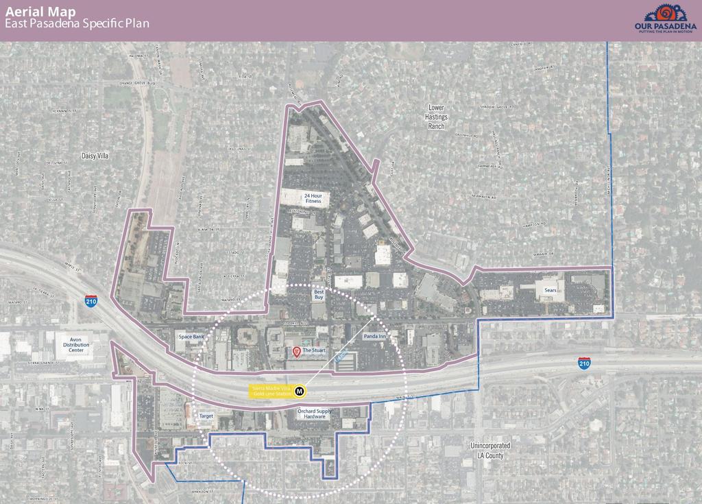
1 East Pasadena Specific Plan Area Community Walking Tour November 17, :00 a.m. 11:00 a.m. Starting Point: Sierra Madre Villa Gold Line Station 149 N. Halstead Street (Courtyard between Gold Line Station and A Noise Within Theater) Ending Point: Fire Station # E. Foothill Blvd. 1. Sierra Madre Villa (SMV) Station A. The SMV Station is located within the East Pasadena Specific Plan Area (SPA). Notice that in order to access the station from Colorado Boulevard, you have to walk through a freeway underpass. How did you feel walking through this area? What could be improved? 2. Ground Floor Commercial Uses and Sidewalks A. Colorado Boulevard contains a variety of uses including hotels, lumber yards, auto uses, medical offices, and big box retailers. Would you like these uses to remain? Are there other uses you would rather see here? B. Is it important for you to have uses that activate the sidewalk, like outdoor dining and cafes? If so, what type of uses would you like to see?
2 C. Do you feel that the sidewalks are too narrow, too wide, or just about right in this area? Is this comfortable for pedestrians? If no, what would make it feel more comfortable? D. Did you notice that some buildings along Colorado Blvd have zero-front yard setbacks? Is this comfortable for pedestrians? If not, what would make it feel more comfortable? 3. Surface Parking Lots A. Notice that several of the properties have surface parking lots in front of their buildings. How does this feel as a pedestrian? What would make it feel more comfortable? Would you prefer surface parking lots to be located behind buildings (or to the side)? B. Would you like to see these surface parking lots provide additional commercial space? If so, what type of uses would you like to see? 4. Colorado/Kinneloa Gateway A. How did you feel crossing Colorado Blvd? Did you feel safe and/or comfortable? Is it different at night than during the day? What could be improved? B. Several intersections could serve as gateways into the neighborhood, such as Colorado/Kinneloa. Would you like to see gateway features or treatments, like paving, arches, medallions, and landscaping? Are there other intersections that could serve as gateways into the plan area?


3 5. Pedestrian Experience A. Now that we have walked along Colorado Blvd, what was the pedestrian experience like? Is there anything that you noticed, such as trees, businesses, or building types that you would like to see more of? Anything you disliked? a. What types of streetscape features would you like to see along Colorado Blvd? Circle and comment on the elements that you like: Outdoor dining Mid-Block Paseo Outdoor Plaza Bioswale in Parkway


")
 Commercial Retail")
4 6. New Development A. Would you like to see redevelopment here? If so, what types of development would be appropriate? B. There are several sample images below please circle the ones that you feel would be appropriate for this area. Low-Rise Residential (2 stories) Low-Rise Residential (3 stories) Mid-Rise Residential (4+ stories) Commercial Retail Low-Rise Mixed Use Mid-Rise Mixed Use Mid-Rise Mixed Use Auto-Oriented Use
5 7. Pedestrian Pathways A. This pathway provides a direct connection between the SMV Station and Foothill Blvd. Do you like this pathway? If so, why? Would you like to see more pedestrian pathways in this area? 8. Foothill Boulevard A. Notice Foothill Blvd what do you think about the mix of uses? Would you want to see more of these uses? B. As a pedestrian, how do you feel walking along this portion of Foothill Blvd? Does it feel different from Colorado Blvd and, if so, why?
6 Tell Us More! Anything else you d like the project team to keep in mind? Are there any topics that were missing from the walking tour?
7
8
Figure 4-10: Pedestrian Improvements Types of Potential Station Area Improvements - Place-Making Improvements
 INCORPORATE FEATURE PAVIN IN CROSSWALK AND INTERSECTION FIELDS Identifies high-priority pedestrian areas and create a station identity through colorful and interesting patterns ADD CURB EXTENSIONS Extending
MEDIAN DESIGN example median A
 MEDIAN DESIGN example median A MLK Blvd Design Workshop #3 September 21, 2010 Participants voted on each idea, gave comments about specific ideas or general comments about all ideas. Comments and suggestions
City of Walnut Creek TELEGRAPH AVENUE BART LINE SELF-GUIDED TOD TOUR 19TH STREET BART STATION
 TELEGRAPH AVENUE City of Walnut Creek BART LINE SELF-GUIDED TOD TOUR 19TH STREET BART STATION Self-Guided TOD Tour With the Walnut Creek BART Station located squarely within its boundaries, the West Downtown
Ocean Park Boulevard Green Street Project Alternatives & Trade Offs
 Planning Commission March 4, 2009 Ocean Park Boulevard Green Street Project Alternatives & Trade Offs Purpose of Tonight s Meeting Review concept plans and options Provide input on alternatives and trade-offs
RIVERSIDE, Newton MA BH NORMANDY RIVERSIDE LLC. Riverside Station. A green, transit-oriented community
 Riverside Station A green, transit-oriented community October 6, 2011 TONIGHT S AGENDA: 1. Project Update (5 min.) 2. Master Plan Update (10 min.) 3.Traffic Plan Update (10 min.) Questions & Answers MASTER
El Camino Real Specific Plan. TAC/CAC Meeting #2 Aug 1, 2018
 El Camino Real Specific Plan TAC/CAC Meeting #2 Aug 1, 2018 Land Use Alternatives Goals and Tradeoffs Parks & open space Housing Retail & services Civic spaces Parking Community gathering spaces 3 Alternatives
Ocean Park Boulevard Streetscape Improvement Project Alternatives & Trade Offs
 City Council Study Session January 27, 2009 Ocean Park Boulevard Streetscape Improvement Project Alternatives & Trade Offs Scope of Work Purpose of Tonight s Meeting Review work to date and direct staff
5 Circulation & Parking
 5 Circulation & Parking Downtown Parking & Circulation Strategy. Downtown Wayne has a somewhat disconnected system of local public streets to connect downtown with the residential neighborhoods, and primary
Chapter 3: Multi-Modal Circulation and Streetscapes
 CHAPTER 3: MULTI-MODAL CIRCULATION AND STREETSCAPES Chapter 3: Multi-Modal Circulation and Streetscapes Overview Streetscape improvements have already been completed for Depot Street between Main Avenue
Garden City State Street Corridor Existing Conditions October 2012
 Garden City State Street Corridor Existing Conditions October 2012 Prepared by Garden City Development Services Leon Letson, Missy Harris & Jenah Thornborrow 6015 Glenwood Street Garden City, Idaho 83714
01. VICINITY OF GREENBRAE POC: EXISTING CONDITIONS
 01. VICINITY OF GREENBRAE POC: EXISTING CONDITIONS Existing Bus Stop Existing US101 On-ramp Existing POC Old Redwood Highway Rich Street City ROW Environmental Study Limit Industrial Way NO DESIGNATED
UPTOWN REGIONAL BIKE CORRIDORS PROJECT SAN DIEGO ASSOCIATION OF GOVERNMENTS
 UPTOWN REGIONAL BIKE CORRIDORS PROJECT SAN DIEGO ASSOCIATION OF GOVERNMENTS SUMMARY REPORT: COMMUNITY UPDATE MEETING February 6, 2014 6 8:30 p.m. Roosevelt Middle School Library 3366 Park Blvd, San Diego
STREETSCAPE CONCEPTS
 STREETSCAPE S CARGO WAY CARGO WAY CYCLE TRACK Streetscape Concepts JENNINGS ST Illustrative Plan EVANS AVE PG&E BAY TRAIL HERON S HEAD PARK The recommended improvements build off the planned improvements
Bridges and Arizona Crossings
 Circulation and Transportation 5-11 Discovery Street/Barham Drive. Discovery Street is planned 5.4.3 Specific Plan Circulation Improvements to be extended eastward from its terminus at Craven Road Circulation
S T A T I O N A R E A P L A N
 The Circulation and Access Plan describes vehicle, pedestrian, and transit improvements recommended within the Concept Plan. In order to create and sustain a vibrant business district that provides pedestrian-friendly
City of Lafayette Public Meeting Agenda Downtown Street Improvement Master Plan Implementation Committee Thursday, April 21, :00 PM
 1. CALL TO ORDER 2. ROLL CALL 3. ADOPTION OF AGENDA 4. PUBLIC COMMENTS 5. OLD BUSINESS 6. NEW BUSINESS City of Lafayette Public Meeting Agenda Downtown Street Improvement Master Plan Implementation Committee
Sidewalk Cafe City of St. Petersburg City Code Chapter 16, Land Development Regulations
 Section 16.50.370 Sidewalk Café Sections: 16.50.370.1 Generally 16.50.370.2 Declarations 16.50.370.3 Definitions 16.50.370.4 Permit Required 16.50.370.5 Application, Permit and Fee 16.50.370.6 Liability
including shade trees; Recommend minimum 13 ft total sidewalk
 Appendix B Projects From Other Plans Location Type of Project Description West. Julian St. Intersection and streetscape along West Julian St. Intersection and scape : Add high visibility side street crosswalks
COMMUNITY WORKSHOP #2 DOWNTOWN CONCORD SPECIFIC PLAN
 COMMUNITY WORKSHOP #2 Timeline 21-month process Tasks 1-3; Basis for the preparation of the plan (Jan. through March) Tasks 4-5; Development and Evaluation of Alternatives. Selection of Preferred Alternative.
Charrette #1 Keypad Polling Results. June 27, 2012
 Charrette #1 Results June 2, 2012 1. My affiliation with Opelika Road is (Choose all that apply) 1 2 Business owner Property owner 12 4 Business owner Property owner 2 1 2 2 Nearby resident Business patron
5 CIRCULATION AND STREET DESIGN
 5 CIRCULATION AND STREET DESIGN This chapter describes circulation and streetscape improvements proposed for the Northwest Chico Specific Plan Area. It includes detailed design specifications for existing
Ocean Park Boulevard Green Street Project Community Workshop
 Ocean Park Boulevard Green Street Project Community Workshop 2.2.10 Project Objectives Community Priority: reclaim OPB for public open space. Build upon LUCE principles; neighborhood enhancement, connectivity,
SETTINGS AND OPPORTUNITIES MOBILITY & ACCESS
 7 mobility & access how do people use el camino what is it like to drive on el camino/to park along el camino what is the pedestrian experience like what is the role of transit along the corridor what
Illustrated Principles of Good Planning
 Illustrated Principles of Good Planning The Miami 21 Zoning Code incorporates time-tested planning principles into the zoning regulations of our City. These are principles that make for better neighborhoods,
Ann Arbor Downtown Street Plan
 1 Ann Arbor Downtown Street Plan Public Workshop #1 We know that. 2 Public right-of-way (streets, sidewalks, and alleys) make up 30% of the total District area of downtown. Streets need to provide mobility
Bicycle and Pedestrian Advisory Committee (BPAC) November 21, 2013
 November 21, 2013") Bicycle and Pedestrian Advisory Committee (BPAC) November 21, 2013 OVERALL LAND USE CONCEPT Overall Broadway Valdez District: 95.5 acres (35.1 acres right-of ways + 60.4 acres developable land) Plan Subareas:
Bicycle and Pedestrian Advisory Committee (BPAC) November 21, 2013 OVERALL LAND USE CONCEPT Overall Broadway Valdez District: 95.5 acres (35.1 acres right-of ways + 60.4 acres developable land) Plan Subareas:
FOCUS AREA 1 - Alberta Avenue Pocket Park 3 (121 Ave and 92 St)
") FOCUS AREA 1 - Alberta Avenue Pocket Park 3 (121 Ave and 92 St) New benches Plant evergreen trees Widen existing sidewalk from 1.5m to 1.8m Marked crosswalk 1.8m wide sidewalk Add pedestrian oriented lights
FOCUS AREA 1 - Alberta Avenue Pocket Park 3 (121 Ave and 92 St) New benches Plant evergreen trees Widen existing sidewalk from 1.5m to 1.8m Marked crosswalk 1.8m wide sidewalk Add pedestrian oriented lights
STREET DESIGN GUIDE CITY OF PASADENA
 T F A DR STREET DESIGN GUIDE CITY OF PASADENA MARCH 2017 Table of Contents 1 Introduction... 1-1 2 Form-Based Framework... 2-1 Function... 2-2 Context... 2-4 Modal Emphasis Overlays... 2-6 Challenges and
York Boulevard Streetscape Master Plan
 York Boulevard Streetscape Master Plan October 24 th, 2008 The Story of York Boulevard Streetscape Master Plan Design. Chapter 126 Dealing with Engineers. 2 1 Today s Presentation Topics: 1. Show the streetscape
Docket No. 16ZONE1044 (Julia Williams, DPDS Case Manager)
") Neighborhood Design Charrettes August 16 & 17, 2017 June 21, 22, 23, September 26 & 28, 2016 Attorneys: Bardenwerper Talbott & Roberts, PLLC Docket No. 16ZONE1044 (Julia Williams, DPDS Case Manager) Zone
Neighborhood Design Charrettes August 16 & 17, 2017 June 21, 22, 23, September 26 & 28, 2016 Attorneys: Bardenwerper Talbott & Roberts, PLLC Docket No. 16ZONE1044 (Julia Williams, DPDS Case Manager) Zone
Strolling down the Avenue
 Strolling down the Avenue Experience the neighbourhood character of Yonge Street between Glengrove and Roselawn Avenues. West Don Ravine Burke Brook Ravine Yonge-Eglinton Centre 1 Strolling down the Avenue
Design Guidelines. Overview. Design Vision for Yellow Brick Road
 Design Guidelines Overview This section presents the design vision for the Yellow Brick Road network. The Yellow Brick Road is envisioned to be an interconnected network of safe and secure roadways where
Multimodal Through Corridors and Placemaking Corridors
 68 Multimodal Through Corridors and Placemaking Corridors Corridors have different functions in a region. Some corridors are used to get smoothly and rapidly through a region or to get quickly to major
Table #6 VISION CHARACTERISTICS
 Table #6 VISION White Flint is a place to live, work, play, shop, and walk with sufficient density to encourage quality redevelopment. Vibrant streets and consistent streetscapes are important. CHARACTERISTICS
CENTENNIAL NEIGHBOURHOODS SECONDARY PLAN STUDY CITY OF HAMILTON SPECIFIC MAP COMMENTS FROM DECEMBER 1st PUBLIC INFORMATION CENTRE #2
 OPTION #2 - MIXED USE MEDIUM DENSITY OPTION #3 - MIXED USE MEDIUM AND HIGH DENSITY Look at other uses besides industrial along Barton Street over the long term. Residential facing waterfront over long
MARTIN LUTHER KING JR. WAY
 OCTOBER 2011 40 Vision and Goals The Martin Luther King, Jr. Way Illustrative Master Plan that follows has been developed through a process of community involvement. It expresses a long term vision for
PUBLIC REALM MASTER PLAN
 WESTSHORE BUSINESS DISTRICT PUBLIC REALM MASTER PLAN MASTER PLAN COMMITTEE MEETING MARCH 20, 2013 WESTSHORE BUSINESS DISTRCT PUBLIC REALM MASTER PLAN MACRO-SCALE CONCEPT: A PUBLIC REALM FRAMEWORK DEFINED
VAN AKEN DISTRICT CONNECTIONS PLAN COMMUNITY MEETING #1 June 20, 2016 SMITHGROUP JJR WSP PARSONS BRINCKERHOFF STUDIO GRAPHIQUE
 VAN AKEN DISTRICT CONNECTIONS PLAN COMMUNITY MEETING #1 June 20, 2016 SMITHGROUP JJR WSP PARSONS BRINCKERHOFF STUDIO GRAPHIQUE 01 02 03 04 05 06 Project Overview + Goals RMS Development District-wide Connections
STREETSCAPE CONCEPT PLAN
 03 STREETSCAPE CONCEPT PLAN Zone 1 This zone includes the gateway into both the downtown and the Village at Harlem. The gateway features are shown closer to the Harlem intersection to make them more prominent.
SURVEY minutes to complete this questionnaire. Your feedback will help the City determine a future design for Ocean Avenue and Geneva Avenue. Thanks!
 OCEAN AVENUE CORRIDOR DESIGN ROJECT WORSHO #4 Thank you for your interest in the Ocean Avenue Corridor Design project. lease take a few SURVEY minutes to complete this questionnaire. Your feedback will
ALPHARETTA CONFERENCE CENTER & THE HOTEL AT AVALON
 BLDG. 3000 BLDG. 5000 11/30/15 BLDG. 2000 RESIDENTIAL OVER RETAIL FIRST ST. BUILDING #7000 5 STORY (UNDER CONSTRUCTION) CENTRAL PARKING DECK PARKING DECK & SURFACE LOT BLDG. 6000 DATE: BUILDING #8000 OFFICE
Slide. Too close together; Don't like the garages in front; Front-facing garages are not nice; Bland; Looks like suburbs; Only see garages
 1 Slide Visual Preference Survey Results Like driveways and less density; Everything looks squeezed in; Street parking is a turn-off; East Coast look; I like the porches; Garages should be in alleys; Too
A Guide to Great Streets: The Basics. September 25, 2009
 A Guide to Great Streets: The Basics September 25, 2009 Streets are more than connectors, they are the city 2 Streets are the glue that hold a city together 3 Streets are the means in which a city is perceived
Report on Walkability Survey and Workshop for ZIP Code Hosted by the Oklahoma City-County Health Department April 13, 2013
 Report on Walkability Survey and Workshop for ZIP Code 73111 Hosted by the Oklahoma City-County Health Department April 13, 2013 On April 13th, the Oklahoma City-County Health Department hosted a community
MIXED USE AND STREETSCAPE INTEGRATION Avondale Will Basil Juliana Zannotto
 MIXED USE AND STREETSCAPE INTEGRATION Avondale Will Basil Juliana Zannotto Creating new development so that people will stop and see what Avondale has to offer The goal for my project was simple. I wanted
FONTAINE AVENUE STUDY Final Report
 FONTAINE AVENUE STUDY Final Report March 28, 2005 FONTAINE AVENUE STUDY City of Charlottesville March 28, 2005 Renaissance Planning Group Kenneth Schwartz, FAIA, AICP Director of Design Leigh Wilkerson,
summary of issues and opportunities
 1 summary of issues and opportunities EXECUTIVE SUMMARY CHAPTER 2: HISTORY - 3: LAND USE This first chapter is an overview of lessons learned from analysis of the existing conditions on El Camino as well
Merrick and Memorial Neighborhood Study 5/14/2014 Public Meeting
 Merrick and Memorial Neighborhood Study 5/14/2014 Public Meeting Study Area April 9 Public Meeting Comments Summary Pedestrian Safety - A Walking Neighborhood Pedestrian traffic is very difficult A need
El Camino Real Precise Plan. Public Draft August 2014
 El Camino Real Precise Plan Public Draft August 2014 Acknowledgments CITY COUNCIL Christopher R. Clark, Mayor John McAlister, Vice Mayor Margaret Abe-Koga Ronit Bryant John M. Inks R. Michael Kasperzak,
CHAPTER 4. CIRCULATION
 CITY OF SAN MATEO CHAPTER 4. CIRCULATION This Chapter describes the pedestrian and automobile circulation system within the Corridor Plan area, as well as design and access considerations for the Hillsdale
12/13/2018 VIA
 12/13/2018 VIA EMAIL Daniel Abbes, Assistant Planner City of Sacramento community Development Department 300 Richards Blvd., 3 rd Floor Sacramento, CA 95811 RE: Bruceville Apartments (P18-073) Dear Mr.
TRANSPORTATION STANDARDS
 INTRODUCTION LOCAL STREETS ON-STREET PARKING SIDEWALKS STREET LIGHTING STREET FURNISHINGS TRAFFIC CALMING STREET TREES MEDIAN PLANTING BOULEVARD LOCATIONS VILLAGE CENTER STREET LOCATIONS RESIDENTIAL STREET
7/23/2017 VIA . Michael Hanebutt City of Sacramento Community Development Department 300 Richards Boulevard, 3 rd Floor Sacramento, CA 95811
 7/23/2017 VIA EMAIL Michael Hanebutt City of Sacramento Community Development Department 300 Richards Boulevard, 3 rd Floor Sacramento, CA 95811 RE: 65 th Street Apartments (DR17-220) Dear Mr. Hanebutt:
Las Tunas Downtown Revitalization City Council Study Session. December 1, :00 p.m. Live Oak Park Community Center
 Las Tunas Downtown Revitalization City Council Study Session December 1, 2015 7:00 p.m. Live Oak Park Community Center AGENDA 2 Provide downtown context. Confirm project goals. Analyze three design concepts.
Completing the Vision
 Villas of Positano Completing the Vision North A1A Lane Reconfiguration N. Surf Rd. Redirection of Traffic Margaritaville Resort March 4, 2014 1 Completing The Vision Project Limits Hollywood Blvd. to
THE PHILADELPHIA COMPLETE. an overview
 THE PHILADELPHIA COMPLETE STREETS DESIGN HANDBOOK an overview WHAT ARE COMPLETE STREETS? Complete Streets are streets designed to accommodate all users, from pedestrians to drivers Complete Streets provide
Replace century-old sewer & water pipes Pedestrian-scale sidewalk lighting
 PROJECT OVERVIEW The Masonic Avenue Streetscape Project is an effort to improve safety for everyone travelling on Masonic Avenue between Geary Boulevard and Fell Street. This project will bring a variety
12/4/2016 VIA . RE: Grocery Outlet Del Paso (DR16-328)
") 12/4/2016 VIA EMAIL Ethan Meltzer, Assistant Planner City of Sacramento Community Development Department 300 Richards Blvd, 3 rd Floor Sacramento, CA 95811 RE: Grocery Outlet Del Paso (DR16-328) Dear Mr.
12/4/2016 VIA EMAIL Ethan Meltzer, Assistant Planner City of Sacramento Community Development Department 300 Richards Blvd, 3 rd Floor Sacramento, CA 95811 RE: Grocery Outlet Del Paso (DR16-328) Dear Mr.
Route Item and Subscale Reliability Table All Countries
 Route Item and Subscale Reliability Table All Countries Route Land Use: Residential Density Item Item Content Range N Inter-Rater Agreement Rater Mean (SD) Frequencies LU2a Single family homes 0-1 407.926
ROUTE 81 CORRIDOR STUDY DESIGN CONCEPTS
 RT 81 Corridor Study CLINTON ROUTE 81 CORRIDOR STUDY DESIGN CONCEPTS View north on High Street, with potential improvements to the streetscape Draft Recommendations November 8 th, 2018 TOWN OF CLINTON
Appendix B - Street Sections
 Appendix B - Street Sections 6TH STREET CORRIDOR PLAN STREET SECTIONS The street sections in Appendix B include recommended improvements to streets for North Glenwood. They include existing conditions
2.0 Ballpark District
 2.0 Ballpark District 2.1 Introduction The Ballpark District is located in the south central portion of the City of Lake Elsinore, just north of the City limit line in this area. The Ballpark District
PEDESTRIAN ACTION PLAN
 CITY OF SANTA MONICA PEDESTRIAN ACTION PLAN DRAFT OCTOBER 2015 Safe Streets Santa Monica, December 3, 2015 Beth Rolandson, AICP Principal Transportation Planner Strategic + Transportation Planning, Planning
Executive Summary Route 30 Corridor Master Plan
 Route Corridor Master Plan Project Overview The Route Corridor Master Plan is a coordinated multimodal transportation and land use plan for the entire stretch of Route through East Whiteland Township,
City of Wilsonville 5 th Street to Kinsman Road Extension Project
 City of Wilsonville 5 th Street to Kinsman Road Walking Tour & Neighborhood Workshop Summary Report Public Outreach Overview On July 18 th, 2017, the City of Wilsonville hosted a neighborhood walking tour
Arapahoe Square Zoning + Design Standards & Guidelines Task Force Meeting 9 January 27, 2016
 Arapahoe Square Zoning + Design Standards & Guidelines Task Force Meeting 9 January 27, 2016 Agenda 3:00 Opening/Welcome 3:15 Touch Base on Schedule and Milestones Moving Forward 3:20 Review the Overall
WELCOME. Thank you for joining us at the Second Public Workshop for the Carlsbad Pedestrian Master Plan. We look forward to receiving your feedback.
 City of Carlsbad Pedestrian Master Plan: WELCOME WELCOME Please Sign In Provide Input at Flip Charts Review Boards Presentation of Draft Plan Thank you for joining us at the Second Public Workshop for
Application of a Complete Street
 Application of a Complete Street Southbend to Prima Vista Update May 14, 2018 Meeting Agenda Perspective and History Public input received Typical sections being considered Presentation of the 2-lane master
A CHANGING CITY. of Edmonton, it is essential that it reflects the long-term vision of the City.
 A CHANGING CITY By the year 2040, Edmonton will be home to more than 1 million people. To accommodate growth and support a healthy and compact city, we need a new approach to development/redevelopment
3/10/2016 VIA th Street, Suite 203 Sacramento, CA
 3/10/2016 VIA EMAIL Arwen Wacht, Associate Planner City of Sacramento Community Development Department 300 Richards Boulevard, 3 rd Floor Sacramento, CA 95811 RE: Natomas Fountains (P16-012) Dear Ms. Wacht:
SPRINGFIELD REVITALIZATION REPORT
 SPRINGFIELD REVITALIZATION REPORT August 2015 Homewood Suites Springfield Town Center Promenade 2 SPRINGFIELD OVERVIEW This report covers recent development activity in the Springfield Commercial Revitalization
URBAN DESIGN BRIEF / BOOKLET
 URBAN DESIGN BRIEF / BOOKLET FUTURE BUILDING / ARCHITECTURAL THEME AND PEDESTRIAN ENTRANCE TANGER OUTLET MALL VISION / IDENTITY The proposed Tanger retail outlet will provide a uniquely themed specialty
Site Analysis and Parti Development
 Site Analysis and Parti Development 32_43 06.11N, 117_09 25.15W Dean Sartain Assignment # 4 AR 650: Programming Instructor: Mirkovich 1. LOCATION within the city. - The site is located between A St & B
Austin Avenue Bridges Project. Public Meeting Summary
 Austin Avenue Bridges Project Public Meeting Summary June 29, 2016 Red Table Safety and Connectivity Notes: 1. Would like to see forensic report evaluations 2. What is the lifespan? 3. Extend safety considerations
WHEREAS delivery trucks also pass through the Narrows, into the northern parking lot, to loading docks in the back of the building.
 CEDAR-ISLES-DEAN NEIGHBORHOOD ASSOCIATION ( CIDNA ) RESOLUTION OPPOSING A DRUG STORE DRIVE THRU, AND COMMENDING DORAN COMPANIES FOR PROPOSING MITIGATING AMENITIES INCLUDING NEW LANDSCAPING AND A DEDICATED
Plainfield Gateway. Plainfield Context
 Plainfield Gateway The western arm of The Campus, much like the Thomas Street Placita eastern arm, must connect residents and workers from the western side of the neighborhood to The Campus and the activity
Community Retail District Summary of Allowable Uses
 Community Retail District Summary of Allowable Uses (Please refer to Section 18-160 for the most up-to-date list: Section 18-160) Accessory Uses Accessory outside display of merchandise Accessory outside
5. Automobile Circulation, Wayfinding and Signage
 5. Automobile Circulation, Wayfinding and Signage Policy: The City Center should have a balanced, safe, and interconnected circulation system that provides expanded travel opportunities for transit, pedestrian,
DRAFT BETTER STREETS PLAN PLAN REVISIONS 2) ATTACHMENTS
 ATTACHMENTS") DRAFT BETTER STREETS PLAN PLAN REVISIONS 2) ATTACHMENTS OCTOBER 2009 Attachment A 10/14/2009 * This section would be added as a sidebar in Chapter 2 (Section 2.3, page 28) of the Draft Better Streets Plan.
DRAFT BETTER STREETS PLAN PLAN REVISIONS 2) ATTACHMENTS OCTOBER 2009 Attachment A 10/14/2009 * This section would be added as a sidebar in Chapter 2 (Section 2.3, page 28) of the Draft Better Streets Plan.
DALLAS MIDTOWN REDEVELOPMENT PLAN FOCUS NORTH TEXAS Peer Chacko, AICP, Assistant Director, City of Dallas
 DALLAS MIDTOWN REDEVELOPMENT PLAN FOCUS NORTH TEXAS 2014 Peer Chacko, AICP, Assistant Director, City of Dallas Dallas Midtown: Strategic growth area Future transit node 2 Peterson Road Study Area Galleria
Citizen Advisory Committee (CAC) Meeting #5 West Anaheim Youth January 27, 2016
 Meeting #5 West Anaheim Youth January 27, 2016") Citizen Advisory Committee (CAC) Meeting #5 West Anaheim Youth January 27, 2016 1 Project Team City: Jonathan Borrego, AICP Planning Manager Susan Kim, AICP Principal Planner Gustavo Gonzalez, AICP Associate
Citizen Advisory Committee (CAC) Meeting #5 West Anaheim Youth January 27, 2016 1 Project Team City: Jonathan Borrego, AICP Planning Manager Susan Kim, AICP Principal Planner Gustavo Gonzalez, AICP Associate
Vision: Traditional hamlet with an attractive business/pedestrian friendly main street connected to adjacent walkable neighborhoods
 N D. Focus Area II Vision: Traditional hamlet with an attractive business/pedestrian friendly main street connected to adjacent walkable neighborhoods Transit Road Focus Area II is located in the Hamlet
State Street Corridor Plan Project Management Team
 MEMO TO: State Street Corridor Plan Project Management Team FROM: Eunice Kim, Planner II, Project Manager Community Development Department DATE: SUBJECT: Summary of Public Input (Subtask 3.7: Memorandum
Community Workshop #1 Summary October 2017
 Community Workshop #1 Summary October 2017 1 Background Pleasure Point has a unique character and strong community identity. In 2008, the community and the County developed the Pleasure Point Community
CITY OF SLO SEEKS INPUT ON PREFERRED ALTERNATIVE FOR BROAD STREET BICYCLE BOULEVARD PROJECT
 City of San Luis Obispo, News Release DATE: August 1, 2017 RELEASE: Immediate CONTACT: Luke Schwartz (805) 781-7190 Transportation Planner-Engineer, Public Works CITY OF SLO SEEKS INPUT ON PREFERRED ALTERNATIVE
glenbrook springdale tod feasibility study
 MARCH 2015 glenbrook springdale tod feasibility study STAMFORD, CT PACKAGE OF COMPREHENSIVE TOD IMPROVEMENTS FOR CTDOT CONSIDERATION GLENBROOK SPRINGDALE TRANSIT-ORIENTED DEVELOPMENT FEASIBILITY STUDY
Broad Street Bicycle Boulevard Design Guidelines
 Broad Street Bicycle Boulevard Design Guidelines Building from the strategies introduced in the 2013 Bicycle Transportation Plan and community input received thus far, City Transportation Staff have identified
Community Advisory Committee (CAC) Meeting #9 West Anaheim Youth Center November 2, 2016
 Meeting #9 West Anaheim Youth Center November 2, 2016") Community Advisory Committee (CAC) Meeting #9 West Anaheim Youth Center November 2, 2016 1 Project Team City: Jonathan Borrego, AICP Planning Services Manager Susan Kim, AICP Principal Planner Gustavo
Community Advisory Committee (CAC) Meeting #9 West Anaheim Youth Center November 2, 2016 1 Project Team City: Jonathan Borrego, AICP Planning Services Manager Susan Kim, AICP Principal Planner Gustavo
Transportation Element
 Transportation Element (2015) Purpose Overland Park strives to create a street and highway network that balances the need for a safe, efficient and well-maintained street network with the desire for environmentally
4 COMMUNITY CHARACTER
 4 This chapter describes the community character of the Plan Area. The focus is on the physical attributes that contribute to the impression of the place for the resident or visitor. These attributes include
STEERING COMMITTEE MEETING June 17, Streetscape Overview Burlington Comprehensive Master Plan
 STEERING COMMITTEE MEETING June 17, 2015 Streetscape Overview Burlington Comprehensive Master Plan 1 Introduction Slide This slide show was presented to the Burlington Steering Committee on June 17, 2015
Ocean Park Boulevard Green Streets Project
 Ocean Park Boulevard Green Streets Project COMMENTS FROM COMMUNITY WORKSHOP 1: LISTENING / MARCH 3, 2008 I. SUMMARY OF COMMENTS This memorandum provides a summary and compilation of all the comments received
DEFINING THE STREETSCAPE DRAFT
 3 DEFINING THE STREETSCAPE Context Sensitive Design Context Sensitive Design The structuring elements of streetscapes for the City of Vaughan are road classifi cation, streetscape type and level of service.
Three Springs Design Guidelines Fencing and Wall Standards
 Three Springs Design Guidelines Fencing and Wall Standards Original Adopted: June 12, 2006 Minor Amendment: December 2012 Minor Amendment: March 23, 2017 TABLE OF CONTENTS: FENCING AND WALLS 1.0 INTRODUCTION
Reconnecting Communities ACTION PLAN FOR LOGAN CIRCLE
 Reconnecting Communities ACTION PLAN FOR LOGAN CIRCLE Project for Public Spaces, Inc. May 2003 Reconnecting Communities ACTION PLAN FOR LOGAN CIRCLE VINE STREET EXPRESSWAY, PHILADELPHIA, PA Prepared by:
Bicycle and Pedestrian Facilities Toolbox (Excerpt from Figure 3.1)
") Appendix B Neighborhood Connections Summaries This Appendix is a supplement to the information presented in Chapter 3 Connect People. The Appendix includes a summary or profile for each of the proposed
Appendix B Neighborhood Connections Summaries This Appendix is a supplement to the information presented in Chapter 3 Connect People. The Appendix includes a summary or profile for each of the proposed
4/14/2017 VIA . Miriam Lim, Junior Planner City of Sacramento Community Development Department 300 Richards, 3 rd Floor Sacramento, CA 95811
 4/14/2017 VIA EMAIL Miriam Lim, Junior Planner City of Sacramento Community Development Department 300 Richards, 3 rd Floor Sacramento, CA 95811 RE: Mack & Franklin Development (P17-016) Dear Ms. Lim:
Community Meeting February 27, 2007 Dorchester Avenue Transportation & Streetscape Improvements Action Plan February 27, 2007
 Community Meeting Tonight s Agenda 6:00 Introductions South Boston/Dot Ave Improvement Study Background 6:15 Consultant Introductions Review of Scope and Schedule Review of Proposed Corridor Wide Guidelines
Complete Street Analysis of a Road Diet: Orange Grove Boulevard, Pasadena, CA
 Complete Street Analysis of a Road Diet: Orange Grove Boulevard, Pasadena, CA Aaron Elias, Bill Cisco Abstract As part of evaluating the feasibility of a road diet on Orange Grove Boulevard in Pasadena,
4.0 STREETSCAPE ELEMENTS
 .0 Table 3 lists streetscape elements and their maintenance requirements. The figures that follow the table illustrate the streetscape elements. With respect to maintenance, if an element is required as