Clyde Walkway Community Links: Crossford Stonebyres Nemphlar- Kirkfieldbank
|
|
|
- Duane Skinner
- 5 years ago
- Views:
Transcription


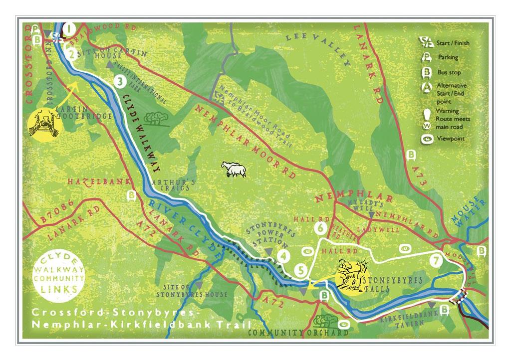
1 Clyde Walkway Community Links: Crossford Stonebyres Nemphlar- Kirkfieldbank Crossford Stonebyres Nemphlar - Kirkfieldbank Digital Trail Difficulty (out of 3) 2 Distance 1. Crossford to Kirkfield Bank Bridge via Stonebyres Weir - 6.2km 2. Crossford to Kirkfieldbank Bridge via Nemphlar 7km 3. Crossford-Stonebyres Falls-Nemphlar circuit 8.6km 4. Crossford-Stonebyres Falls-Nemphlar: circuit via Clydesholm Bridge 8.8km Terrain Overview including alternative start / end points A mixture of pavement, wooded paths and farm tracks. Can be muddy after heavy rain. This is a lovely route following the Clyde Walkway from Crossford to Kirkfieldbank, or vice versa, with the opportunity to loop round by the picturesque village of Nemphlar, with elevated views over the Clyde Valley. Crossford lies at the heart of what was once known as the Fruit Basket of Scotland. The highlight of this walk is Stonebyres Falls the furthest downstream of the four falls that together are known as the Falls of Clyde. To some they are the finest of the four and are most clearly viewed in winter when the trees on the wooded gorge are bare. Refreshments are available in both Crossford and Kirkfieldbank. Stop in the Kirkfieldbank Tavern to admire Alasdair Gray s 25 foot long mural, The Falls of Clyde, (1969). You could choose to keep following the Clyde Walkway at either end: upstream to the Falls of Clyde at New Lanark: downstream through Rosebank and Dalserf (link to CL trail), and beyond to Strathclyde Park, Bothwell, Cambuslang and Glasgow. Walk / cycle / horseride: Some sections are suitable for all, others are not. Start / Park: You can park in the car park just off Smuggler s Brig Road turn left past the Clyde Valley Dental Practice and public toilets if following Lanark Road towards Lanark. Public Transport: If arriving by bus, the bus stops on the main Lanark Road, close to the car park, near the post office. Check Traveline Scotland ( for details of the frequency of services.
2 Stages of Walk 1. Crossford to Clyde Walkway (500 metres) From the car park, return to Lanark Road and go left in the direction of Lanark. About 300m on turn left for Braidwood, across Crossford Bridge over the Clyde. Once over the bridge take first right into Valley International Park. After a few metres take the path off to the right you are now on the Clyde Walkway. 2. Clyde Walkway to Big Wood (1 km) This section keeps you alongside the river. After about 500m if you look to your right you will see, crossing the Clyde, the picturesque Carfin Footbridge a Victorian wrought iron suspension footbridge built as part of Carfin Estate which occupied the northern bank of the river at this point. Little remains of the estate buildings other than the stables and walled garden which now form part of the disused visitor centre. Keep following the Clyde upstream and go through a kissing gate where the path enters Big Wood. 3. Big Wood to Stonebyres Hydro-Power Station (2.5 km) Continue along the path, with the River Clyde to your right and Big Wood to your left. Pass through Big Wood, crossing a timber bridge where Big Wood ends and the landscape to your left is opened up to rolling Clyde valley farmland. Keep following the path, over the timber bridge at Carlinside Strip. The path now ascends high above the Clyde within woodland, and is delineated by decorative metal post and rail fencing on the riverside. Eventually you will have a view of Stonebyres Hydro Power Station the first of two (the other is Bonnington Hydro-Power Station) electricity generating stations built in 1927 to harness the power of the Clyde. 4. Stonebyres Hydro-Power Station to Stonebyres Linn (300 metres) A short distance ahead you will see Stonebyres Linn (Falls) the furthest downstream of the four Falls of the Clyde (the others, going upstream, being Dundaff, Corra and Bonnington). At 21 metres high, Stonebyres Linn is the first natural barrier to migrating salmon and sea trout on the Clyde, preventing them from reaching the waters of the upper Clyde. (From here, instead of continuing with this guide, you have the option of staying on the Clyde Walkway to Kirkfieldbank and carrying on to New Lanark and the Falls of Clyde.)
3 5. Stonebyres Linn to Nemphlar (800 metres) At Stonebyres Linn, when facing upstream (river on your right), take the path to your left at the wee concrete bridge, leaving the Clyde Walkway and heading towards the village of Nemphlar. The path first ascends steps and then takes you uphill across the edge of a field, following the fence. Cross over a stile and continue uphill on the overgrown track, making sure you turn round to enjoy sweeping views of the Clyde Valley. 6. Nemphlar to Mousemill Road (1 km) When the track meets Hall Road in Nemphlar, turn right, enjoying views onto the distinctive steeples of Lanark. A VC memorial remembers a war veteran here. Head east along Hall Road through the village of Nemphlar, following a right bend at Halltown of Nemphlar bastle house (partly fortified house, originating in the 16th century in the Scottish borders). At the junction, about 330m along, go right into Welldale Lane, ignoring the dead-end road sign. After just under 200m the road becomes farm track. Follow the track as it ascends and then descends again, along the beech lined avenue. Look out for the stone bench on your right before the path begins to descend again and take the chance to rest your legs and take in more sweeping views of Lanark and the Clyde Valley. 7. Mousemill Road to Kirkfieldbank Community Orchard (1.5 km) The farm track eventually comes out at Mousemill Road turn right onto this and then bear right at the junction just ahead. After about 200m you will pass Mousemill on your right before crossing the Mouse Water via Mousemill Bridge. In the past, the fast flowing Mouse was used to power mills and factories along its route and is still used today to produce hydroelectricity. When Mousemill Road meets the busier A72 Lanark Road, turn right onto it and follow the pavement over Kirkieldbank Bridge, crossing the River Clyde. Follow the pavements through the village of Kirkfieldbank with the Clyde on your right. (Alternatively, you can choose to take a small detour via Clydesholm Bridge, adding on just under 300m: instead of crossing the main road bridge, cross the road and take the path to the left leading away from the road to some houses; go right onto Clydesholm Bridge and keep right to bring you back to the main road to re-join the main described route. The old, three arched Clydesholm Bridge, was built in 1699 and was the main crossing in the village before Kirkfieldbank Bridge was built in It was designed by James Lockhart of the local Lockhart family, whose estate was centred on the Lee Castle near Lanark.) Heading along the A72, you will pass the Riverside Tavern to your left where you can stop off for a refreshment and to admire Alasdair Gray s The Falls of Clyde mural (1969), spanning the full 25 foot length of the wall. Continue along the A72 passing on your left, Kirkieldbank Primary School, Nicholson s Plastics and then a row of houses before coming to Kirkfieldbank Community Orchard, sloping up the hill from the road. You might like to head into the orchard and up the small hill for a lovely view over the picturesque bend in the Clyde as it meanders towards Lanark.
4 8. Kirkfieldbank Community Orchard to Stonebyres Falls via Stonebyres Weir (footbridge) (700 metres) From Kirkfieldbank Community Orchard, cross over the road to the pavement and continue along the A72. After about 80m take the tarmac path to the right (leading away from the road) and through the metal gates. In just under 400m take the path to right, over Stonebyres Weir, crossing the Clyde. After another 180m you will have completed a circuit and returned to the path turning for Nemphlar (on your right). Keep left, staying on the Clyde Walkway, passing Stonebyres Falls again and eventually returning to your start point in Crossford. End: Please respect the Scottish Outdoor Access Code. As with all outdoor activities, walking can present hazards. It is the access-taker s responsibility to judge whether they can take access safely in any given situation. This route guide does not give any guarantee of path conditions.
5
6
Clyde Walkway Community Links Walks linking communities with the Clyde Walkway
 Clyde Walkway Community Links Walks linking communities with the Clyde Walkway Clyde Walkway Community Links Walks linking communities with the Clyde Walkway The Clyde Walkway Community Links project improved
Clyde Walkway Community Links: Nemphlar Moor Road to Braidwood
 Clyde Walkway Community Links: Nemphlar Moor Road to Braidwood Nemphlar Moor Road to Braidwood Digital Trail Difficulty (out of 3) 2 Distance Main route to Braidwood (shortest) 2.5km, 5km return. Detours
Clyde Walkway Community Links: Rosebank Circular via Ashgill and Dalserf
 Clyde Walkway Community Links: Rosebank Circular via Ashgill and Dalserf Rosebank Circular via Ashgill and Dalserf Digital Trail Difficulty (out of 3) 1 Distance 7 km / 4.35 miles. Time 2 hours Terrain
HARDMOORS 26.2 WHITE HORSE HALF ROUTE DESCRIPTION - 018
 HARDMOORS 26.2 WHITE HORSE HALF ROUTE DESCRIPTION - 018 Follow Cleveland Way, keeping to the left hand path (right path is a bike trail) Ignoring any turnings to the left or right At path junction (after
The North Pennines from near Langwathby
 3.6 Langwathby to Armathwaite Map panel?? Distance 12.7 miles (20.5 km) Terrain farm, woodland and riverside paths; some potentially muddy tracks; a few short sections of road Grade gently undulating Food
A Walk around Holmes Chapel starting & finishing at Holmes Chapel Railway Station. by Tony & Lindsay Wright (2016)
") A Walk around Holmes Chapel starting & finishing at Holmes Chapel Railway Station. by Tony & Lindsay Wright (2016) Introduction Holmes Chapel Railway Station is on the Crewe to Manchester line. The station
A Walk around Holmes Chapel starting & finishing at Holmes Chapel Railway Station. by Tony & Lindsay Wright (2016) Introduction Holmes Chapel Railway Station is on the Crewe to Manchester line. The station
Welsh Newton and Woodland
 Welsh Newton and Woodland This is a 8.2km miles (approx) walk which will take about 2.5 hours at a relaxed and leisurely pace. There are a few hills but no steep inclines. Start at Llangrove bus stop and
Thornton le Dale Walks
 Thornton le Dale Walks A collection of walks in and around the village Thornton le Dale Traders Forum www.visitthorntonledale.co.uk Thornton le Dale Walks Walk 1: Beck Isle Cottage and All Saints Church
Thornton le Dale Walks
 Thornton le Dale Walks A collection of circular walks in, and around, the village www.visitthorntonledale.co.uk Thornton-le-Dale Traders Forum and Thornton le Dale Parish Council 1 Thornton le Dale Circular
Danbury Words and pictures by Laurie Page of the Public Rights of Way team at Essex County Council.
 Danbury Words and pictures by Laurie Page of the Public Rights of Way team at Essex County Council. An undulating walk from Danbury village to the bluebells at the National Trust property of Blakes Wood.
Husthwaite to Byland Abbey
 Husthwaite to Byland Abbey This walk begins with a loop round the village of Husthwaite and continues towards Coxwold along a disused railway line, which is now a right of way. It passes through Coxwold
8 Miles Circular 4 hours
 VISIT RYEDALE HELMSLEY AND RICCAL DALE 8 Miles Circular 4 hours 090616 Challenging Terrain An 8 mile (13km) circular walk from the market town of Helmsley in Ryedale. The route heads out across sheep pastures
10 Miles Circular 5 hours
 VISIT RYEDALE PICKERING AND CAWTHORN CAMPS 10 Miles Circular 5 hours Moderate Terrain 120616 A 10 mile (16km) there and back walk from the market town of Pickering in Ryedale. The route heads north through
For more information and to buy this book click here ISBN: CICERONE. Guides for walkers, trekkers, mountaineers, climbers and cyclists
 For more information and to buy this book click here ISBN: 9781852845377 CICERONE Guides for walkers, trekkers, mountaineers, climbers and cyclists www.cicerone.co.uk WALK 5 Ouston and Urpeth Distance
Cilgerran Wildlife Park Circular Walk
 Walking embrokeshire Cilgerran Wildlife ark Circular Walk It s good to walk, so why not step out and sample some of the walks your neighbourhood has to offer. This pleasant and interesting walk which starts
BALCOMBE AND ARDINGLY RESERVOIR, WEST SUSSEX
 BALCOMBE AND ARDINGLY RESERVOIR, WEST SUSSEX 7 miles Circular 4 hours 080816 Challenging Terrain Hi, I'm Luke and this is my West Sussex Weekends walk It's a 7 mile loop from Balcombe rail station, taking
Waterhead Pier to Orrest Head, Windermere and Bowness
 Waterhead Pier to Orrest Head, Windermere and Bowness A 4 1 2 hour walk through Woodlands and the Troutbeck Valley with spectacular Lake and Mountain views and a lakeshore path. Walk 10 Walk 11 Walk 12
THE WELLDIGGERS ARMS, HESWORTH AND FITTLEWORTH TRAIL
 THE WELLDIGGERS ARMS, HESWORTH AND FITTLEWORTH TRAIL 5.5 miles Circular 3 hours 041017 Challenging Terrain A 300-year-old pub turned country-inn on the edge of the South Downs National Park, The Welldiggers
9.5 km Circular 3 hours
 RANMORE CIRCULAR A 6 mile (9.5km) circular walk from Boxhill and Westhumble Station in the village of Westhumble, passing through part of the Polesden Lacey Estate, Ranmore Common and Denbies Vineyard.
LOCAL CIRCUIT EM1: EAST MALLING & BARMING HEATH. N 2m ROADS: Significant roads PATHS: Starting direction Barming Longsole Mission Church
 Ditton Church Scott Close LOCAL CIRCUIT EM1: EAST MALLING & BARMING HEATH 6 Community Centre F Open fields (see 'Introductory Notes') 1m 88 Direction label (as in the walk notes) East Malling Church -
WETHERBY CIRCULAR by Tania Dickinson
 WETHERBY CIRCULAR by Tania Dickinson This walk in lower Wharfedale includes a disused railway line at the beginning and riverside at the end, with parkland, fields, woodland and villages in between. Distance
The Mendip Way. Route Directions and Maps Wells to Frome
 The Mendip Way Route Directions and Maps Wells to Frome Website: www.mendiphillsaonb.org.uk Email: mendip@mendiphillsaonb.org.uk Facebook & Twitter: @MendipHillsAONB Phone: 01761462338 1 Wells to Shepton
NETTLESTEAD & YALDING
 NETTLESTEAD & YALDING ULL CIRCUIT - Sheet 1 (first and last sections) Open fields (see 'Introductory Notes') 88 Direction label (as in the walk notes) ROADS: 81 10m Significant roads Redhill arm North
LDWA SOUTH DOWNS MARATHON 13 th MAY 2018
 AHD ahead SDW South Downs Way BL/BR bear left/bear right TL/TR turn left/turn right X cross LEG 1 - EAST DEAN to WP1 NORTON GR 470019. Open 1030 to 1300. 9.7 miles. 1.1 From village hall TL and walk to
Walk Description. Directions
 Title: Saffron Trail: Battlesbridge to Chelmsford Distance: 14¾ miles Time taken: 6 hours Start Point: Outside the Barge Inn, Battlesbridge OS Explorer Map: 175 & 183 Grid Ref.: TQ 780 947 Transport: Rail:-
9.5 km Circular 3 hours
 MEDIEVAL WAVERLEY Challenging Terrain A 6 mile (9.5km) undulating circular walk from Tilford village passing close to The Sands village and the historic ruins of Waverley Abbey. From the top of Crooksbury
LDWA SOUTH DOWNS MARATHON
 AHD ahead SDW South Downs Way BL/BR bear left/bear right TL/TR turn left/turn right SP signpost/fingerpost X cross LEG 1 - EAST DEAN to WP1 NORTON GR 470019. Open 1030 to 1300. 9.6 miles. 1.1 From village
THE DOG AND DUCK HAREWOODS ESTATE TRAIL. 6 Miles Circular 3 hours. Getting there. Walk Sections
 THE DOG AND DUCK HAREWOODS ESTATE TRAIL Moderate Terrain A 6 mile circular pub walk from the Dog and Duck in Outwood, Surrey. The Dog and Duck is a delightful pub where everyone is made welcome. From walkers
EAST GRINSTEAD AND THE HIGH WEALD, WEST SUSSEX
 EAST GRINSTEAD AND THE HIGH WEALD, WEST SUSSEX 7 miles Circular 3.5 hours 301015 Challenging Terrain Hi, I'm Tom and this is my West Sussex Weekends walk. I live and work in London but often head out of
Approximate distance: 5.5 miles For this walk we ve included OS grid references should you wish to use them. Start. End
 Approximate distance: 5.5 miles For this walk we ve included OS grid references should you wish to use them. End 4 1 Start 3 2 N W E S Reproduced by permission of Ordnance Survey on behalf of HMSO. Crown
SUMMER WALK 10. The Chairmakers, Worlds End
 SUMMER WALK 10 The Chairmakers, Worlds End Tuesday 10 th June 7.30pm This is a very short walk made so due to the majority of the footpaths in the area around the Chairmakers being overrun with high nettles
Dyrham and Hinton Parish Walks
 Dyrham and Hinton Parish Walks A series of five walks in the parish, exploring most of the public footpaths. By John Miller Each walk is described in detail, with a complete map, to provide a handy guide
Lincolnshire Limewoods Walks. Woodhall Spa. A circular walk of 13km (8 miles)
") Lincolnshire Limewoods Walks Woodhall Spa A circular walk of 13km (8 miles) Introduction The Lincolnshire Limewoods is an area between Wragby, Bardney and Woodhall Spa. It is a fantastic place to explore
Lincolnshire Limewoods Walks Woodhall Spa A circular walk of 13km (8 miles) Introduction The Lincolnshire Limewoods is an area between Wragby, Bardney and Woodhall Spa. It is a fantastic place to explore
Walk 7: Watchet to washford
 Walk 7: Watchet to washford Length: Moderate - 7.5 miles / 12 km Good For: Theme: History Duration: 2-3 hours depending on speed of walking Notes: This is a moderate to difficult walk in places, with steps,
Follow the Lantern Way clockwise from Dursley Town Hall through Cam & Coaley to Uley and back to Dursley (about 14 miles)
") According to the Rev Kilvert's diary of 1873, couples on their way to evening services in winter followed a practical though unusual local tradition: "My Mother says that at Dursley, when ladies and gentlemen
According to the Rev Kilvert's diary of 1873, couples on their way to evening services in winter followed a practical though unusual local tradition: "My Mother says that at Dursley, when ladies and gentlemen
This walk description is from happyhiker.co.uk
 This walk description is from happyhiker.co.uk Pendle Hill Walk From Barley Starting point and OS Grid reference Ordnance Survey map Distance Traffic light rating Barley village honesty box car park OS
Walking Pembrokeshire.
 Walking Pembrokeshire Canaston Woods Walk It s good to walk, so why not step out and sample some of the walks your neighbourhood has to offer. This pleasant and interesting walk which starts and finishes
THE PONTON PLOD - 27 MILE ROUTE
 THE PONTON PLOD - 27 MILE ROUTE Emergency Phone Number 07771 813514 Abbreviations: BW Bridleway X Cross immd immediately FP Footpath TL Turn left L Left thro through KG Kissing Gate TR Turn right R Right
A mainly flat walk along the Peak Forest Canal to Castle Hill and returning along the River Tame via Hulmes Wood and Haughton Dale.
 Walk 9 Haughton Green, Peak Forest Canal, Castle Hill, Hulmes Wood, River Tame, Haughton Dale Circular Miles: 3.9 Time: 1 Hour 30 Minutes Grade: Easy To Moderate Starting Point: Junction Of Gibraltar Lane/Newport
Route: Skewsby Foulrice Stearsby
 Route: Skewsby Foulrice Stearsby Distance: 7 miles Map: Explorer: 300 Howardian Hills & Malton Start (OS ref): SE625710 Park in the village of Skewsby. Walk east out of the village to the T-Junction and
Bakewell Club Site - Robin Hood's Stride
 Bakewell Club Site - Robin Hood's Stride Camping and Caravanning Route Summary A circular walk with fabulous views winding it's way through the beautiful White Peak scenery. Points of interest include
Hammer Vale and Linchmere Common
 point your feet on a new path Hammer Vale and Linchmere Common Distance: 9 km=5½ miles or 6 km=3¾ miles easy walking with one steep section Region: Hampshire, West Sussex Author: Botafuego Refreshments:
How to get there. Respect - Protect - Enjoy
 How to get there Driving: Postcode is RG9 5PF and there is a car park just across from the pub. Nearest station: Henley-on-Thames station is 5.6 miles away. We re delighted to present three circular walks
There are toilets at Manningtree Station, Flatford (close to the hump back bridge) and in Dedham.
 and in Dedham.") Arriving by Train Main Features of the Walk Outline Route Employs particularly attractive paths, many of which offer impressive views across Dedham Vale. Includes a section along the tidal section of the
Arriving by Train Main Features of the Walk Outline Route Employs particularly attractive paths, many of which offer impressive views across Dedham Vale. Includes a section along the tidal section of the
10 km Circular 3 hours
 FRIMLEY AND FRIMLEY GREEN 10 km Circular 3 hours Easy Terrain 250716 A 10km (6 mile) circular walk exploring the canal towpath, riverside path, woodland, heath and small settlements around Frimley in Surrey.
Dorridge & District Residents Association A Walk Along The Green Belt From Dorridge to Catherine-de-Barnes
 Dorridge & District Residents Association A Walk Along The Green Belt From Dorridge to Carine-de-Barnes The starting section of this walk through open fields would be destroyed by building of motorway
Ovington and Itchen Stoke
 Trail Activity Type Terrain Author Distance Ascent Location : HAMPTR0057 : Walk : Pub : Towpaths and Cycle Tracks : Peter Carne : 1.4 miles / 2.2 kms : 62 feet / 19 metres : SU560318 / SO24 0RE Bush Inn,
& r al. Two circular walks of 8 km (5 miles) wal k
 wal k") & Ru r al Two circular walks of 8 km (5 miles) s ford Riv m a t S er wal k Introduction Stamford is noted as being one of the finest stone towns in the country. The stone being local limestone and Collyweston
& Ru r al Two circular walks of 8 km (5 miles) s ford Riv m a t S er wal k Introduction Stamford is noted as being one of the finest stone towns in the country. The stone being local limestone and Collyweston
Green Man Ultra Route Directions 2018
 Green Man Ultra Route Directions 2018 Start-CP1 (9 miles) Community Forest Path (CFP) Frome Valley Way (FVW) From the starting line cross the playing fields diagonally to the metal gates in the hedge lined
Heartwood Forest, in Sandridge, Hertfordshire, is a place where everyone can find space, peace, wildlife and miles of beautiful woodland to explore.
 Heartwood Forest Accessibility Statement September 2016 Purpose: This accessibility statement outlines the available facilities and access information for Heartwood Forest. Welcome We, the Woodland Trust,
The Hundred Parishes
 The Hundred Parishes Walks from railway stations number 9 6.4 miles (10kms) from Bishop s Stortford to Stansted Mountfitchet Start: Bishop s Stortford station (Grid Reference TL492209) (ample parking and
SWC Bedfordshire walks Sandy and Biggleswade
 SWC Bedfordshire walks Sandy and Biggleswade Main Walk: Sandy to Biggleswade via Northill and Old Warden 19.5km (12.2m), toughness 4/10. Long Walk: Sandy Circular - Main Walk plus route from Biggleswade
Approximate distance: 10 miles For this walk we ve included OS grid references should you wish to use them. Start. End
 Approximate distance: 10 miles For this walk we ve included OS grid references should you wish to use them. 2 3 Start End 1 N W E S Reproduced by permission of Ordnance Survey on behalf of HMSO. Crown
Walk 2: Beamsley Beacon and Bolton Abbey
 Walk 2: Beamsley Beacon and Bolton Abbey Start and Finish: The Memorial Hall, Main Street, Addingham, LS29 0LZ, SE 079 497 The shortest walk is about 5½ miles (8.8km) The medium Walk is about 8¼ miles
6 Miles Linear 3 hours
 SPIRES AND STEEPLES Part 2: BRANSTON TO METHERINGHAM 6 Miles Linear 3 hours 160818 Moderate Terrain A 6 mile (10km) linear walk from Branston to Metheringham, forming the second part of the Spires and
North Downs Way Monster Alternative North Downs Way Double Walk Box Hill or Dorking to Newlands Corner or Guildford
 point your feet on a new path North Downs Way Monster Alternative North Downs Way Double Walk Box Hill or Dorking to Newlands Corner or Guildford Distance: 0 or 6 km=8½ or 6 miles (by rail) or 6 km=½ miles
Redesdale Arms. A Trio of Walks
 Redesdale Arms A Trio of Walks Welcome to The Redesdale Arms Hotel The award winning 34 bedroom Redesdale Arms Hotel sits at the gateway to the Cotswolds in the High Street of the historic town of Moreton-in-Marsh.
Loch Ness Shores Club Site
 Loch Ness Shores Club Site Camping and Caravanning Falls of Foyers Route Summary A strenuous walk from Loch Ness Shores Club Site. The route climbs through forest to The Upper Foyers Waterfall and then
THE BECK STONE Backstone Beck on Ilkley Moor
 THE BECK STONE Backstone Beck on Ilkley Moor 1 Three different routes which take in the best of the lower slopes of Ilkley Moor, with bracken, heather, a tarn (a small mountain lake) and rushing streams.
Oldbury & Littleton, South Gloucestershire
 Oldbury & Littleton, South Gloucestershire Starts at Church Lane, Oldbury. BS35 1QF 2 hours 0 minutes 5.2miles 8.4km Easy ID: 0.2468 Developed by: GEOFF MULLETT Checked by: Marion Stone www.ramblersroutes.org
Staplehurst to Headcorn or Cranbrook
 Staplehurst to Cranbrook last checked Frittenden to Bubhurst last checked Goudhurst ending last checked Sissinghurst village to Headcorn checked 12 May 2018 14 April 2014 1 April 2017 12 July 2017 Document
Slindon Folly - South Downs, West Sussex
 Slindon Folly - South Downs, West Sussex Starts at Park road-side near entrance to Slindon College 2 hours 15 minutes 4.5miles 7.2km Easy ID: 0.1598 Developed by: Chris Mumford Checked by: Rockpit www.ramblersroutes.org
Lincolnshire Walks. Grainthorpe. Three circular walks of 2 ¾, 9 and 9 ½ km (1 ¾, 5 ½ and 6 miles)
") Lincolnshire Walks Grainthorpe Three circular walks of ¾, 9 and 9 ½ km (1 ¾, ½ and 6 miles) Introduction Explore the coastal marshes, arable hinterland, Louth Navigation canal and the village of Grainthorpe
Lincolnshire Walks Grainthorpe Three circular walks of ¾, 9 and 9 ½ km (1 ¾, ½ and 6 miles) Introduction Explore the coastal marshes, arable hinterland, Louth Navigation canal and the village of Grainthorpe
The main feature of this tranquil walk is a visit to the source of the Thames (the Thames head) which is in a field just 3 km from Kemble station
 which is in a field just 3 km from Kemble station") SWC Walk DRAFT Kemble circular: the source of the River Thames. The main feature of this tranquil walk is a visit to the source of the Thames (the Thames head) which is in a field just 3 km from Kemble
SWC Walk DRAFT Kemble circular: the source of the River Thames. The main feature of this tranquil walk is a visit to the source of the Thames (the Thames head) which is in a field just 3 km from Kemble
RILLINGTON TO MALTON by Tania Dickinson
 RILLINGTON TO MALTON by Tania Dickinson This walk takes you from the Vale of Pickering up on to the Wold scarp, before dropping down again through the pretty village of Settrington and joining the Centenary
No. 1 By River Ribble & Brungerley Park 3¼ Miles,
 RVRNEWS 102 No. 1 By River Ribble & Brungerley Park 3¼ Miles, Approx 2 Hours This walk starts at the gate on platform 2 of Clitheroe station. Leaving the station turn left making towards Kirkmoor Rd and
Bagshot Heath and Swinley Forest
 point your feet on a new path Bagshot Heath and Swinley Forest Distance: 13 km=8 miles Region: Berkshire, Surrey Author: Botafuego Refreshments: Forest Look Out, Bagshot easy walking Date written: 17-feb-2013
Hascombe and Winkworth Arboretum Downs Link Path, Smithbrook Kilns
 point your feet on a new path Hascombe and Winkworth Arboretum Downs Link Path, Smithbrook Kilns Distance: 18 km=11 miles Region: Surrey Author: RDC easy walking Date written: 7-may-2016 Last update: 30-aug-2018
How to get there. Respect - Protect - Enjoy
 How to get there Driving: Postcode is RG9 3DG and there is a carpark just across from the pub. Nearest station: Henley-on-Thames station is 5.6 miles away. We re delighted to present three circular walks
Walk 2 Village Hall - The Shippy - Woodhouse Farm - Village Hall
 Walk 2 Village Hall - The Shippy - Woodhouse Farm - Village Hall The walk is approximately 4km (2.5 miles) across fairly flat countryside with about a quarter on country lanes. It should take about 1 hour
Pull the gate towards you and ride through. The third gate takes you onto Hound House Road. Watch out for traffic. 4
 PEASLAKE TO FARLEY HEATH AND WINTERFOLD 12k CIRCULAR ROUTE 2HRS GU5 9QW This interesting trail takes you across a variety of terrain, from the sandstone of Pitch Hill, across open farmland with fabulous
CHINTHURST HILL AND THE GRANTLEY ARMS, SURREY
 CHINTHURST HILL AND THE GRANTLEY ARMS, SURREY 4 miles Circular 2 hours 110417 Challenging Terrain A 4 mile (can be shortened to 3 miles) circular pub walk near Wonersh in Surrey. The walk begins with an
Walk 2: doniford to east quantoxhead
 Walk 2: doniford to east quantoxhead Length: 9 ¼ miles / 15km Good For: Difficulty: Moderate Theme: Nature Notes: This walk is tidal - please check tide times before setting off. Dogs are welcome but need
Walks Around Bishopstone & Hinton Parva
 The Walks: From ½ mile ambles to 8 mile scenic loops Hinton Parva Walks H1 H2 H3 Bishopstone Walks B1 B2 B3 B4 B5 Walk B1: Bishopstone Village, The Dingle (stream) & Pond A short circular village amble
3 3 Craigellachie to Ballindalloch
 3 3 Craigellachie to Ballindalloch Map panel 2 (inside back cover) Distance 12 miles 19 km Terrain disused railway trackbed Grade flat Food and drink Craigellachie, Aberlour and Ballindalloch (shop) Side-trips
Masson Hill. Walk. Approximately 4 km. Moderate Walk Begins from Matlock Railway Station
 Masson Hill Walk Approximately 4 km Moderate Walk Begins from Matlock Railway Station TOWN WALKS Masson Hill walk is approx. 4 km. It can be walked in a couple of hours or so. Enjoy your walk and the beautiful
GENERAL INFORMATION PLEASE FOLLOW THE COUNTRYSIDE CODE:
 KNIGHTON CIRCULAR WALKS The East Radnor Group of the Ramblers Association invites you to enjoy these walks around Knighton. Knighton is an excellent centre for walks in the lovely unspoilt mid-wales countryside
Dead Horse Gap Loop track
 Dead Horse Gap Loop track 4 hrs 30 mins Hard track 9.8 km Circuit 144m 4 This walk starts with a ride up the Kosciuszko Express Chairlift. There is an opportunity to eat at Australia's highest restaurant,
A circular walk of or km (2 1 4 or miles)
") Grantham A circular walk of 3 3 4 or 5 3 4 km (2 1 4 or 3 1 2 miles) Introduction This relatively short circular walk, which starts in the middle of Grantham, offers plenty of variety. The route takes
Grantham A circular walk of 3 3 4 or 5 3 4 km (2 1 4 or 3 1 2 miles) Introduction This relatively short circular walk, which starts in the middle of Grantham, offers plenty of variety. The route takes
Although the majority of these walks are around country lanes you should still follow the Country Code:-
 With the update of the Parish Plan was a request for details of any Walks around Pillaton The following pages give several walks that I and my wife have done for many years. Please be aware that NONE OF
Harlington - Sharpenhoe - Pulloxhill
 Harlington - Sharpenhoe - Pulloxhill ID: 3676, Distance: 8 miles, Height gain: 140 Metres, Map: Explorer 193 Luton & Stevenage, Contributor: Dennis Jeanes Duration: 3 Hours 27 Mins Features Church,Great
Key Information. Self-Guided Walk Exploring Sedbergh
 Self-Guided Walk Exploring Sedbergh A great short walk - ideal for an early evening in summer. This is a lovely circuit of Sedbergh visiting some of the historic buildings as well as ambling by the river
Guildford to Gomshall
 Morning last checked Afternoon last checked Option c) last checked Option d) last checked 9 April 2016 9 April 2016 9 April 2016 23 December 2017 Document last updated: 4 May 2018 This document and information
Discover Shropshire. Walks and Strolls around Bridgnorth
 Discover Shropshire Walks and Strolls around Bridgnorth An Introduction to Bridgnorth Bridgnorth is made up of two towns; the High Town and the Low Town. The Low Town was once a thriving port along the
11 Miles Linear 5 to 6 hours
 11 Miles Linear 5 to 6 hours Sussex Hospices Trail Part 21: BALCOMBE TO HORSHAM Moderate Terrain 030918 An 11 mile linear walk from Balcombe rail station to Horsham rail station in West Sussex, forming
The Railway from Pill Junction to Portishead in March 2015
 The Railway from Pill Junction to Portishead in March 2015 A series of pictures taken to record the status of the old line following the major clearance operation Never assume you are safe on or near old
West Hoathly and Gravetye Manor
 point your feet on a new path West Hoathly and Gravetye Manor Distance: 8½ km=5½ miles or 7 km=4½ miles easy walking with one gradient Region: West Sussex Author: Sackboot Refreshments: West Hoathly Date
6 Miles Linear 3 hours
 6 Miles Linear 3 hours SUSSEX HOSPICES TRAIL PART 2: BARNHAM TO ARUNDEL Moderate Terrain 131016 A 6 mile linear walk from Barnham rail station to Arundel rail station in West Sussex, forming the second
Banstead: Village and Woods
 point your feet on a new path : Village and s Distance: 10 km=6 miles Region: Surrey Author: Fusszweig Refreshments:, The Ramblers Rest easy walking Date written: 2-apr-2014 Last update: 11-apr-2017 Map:
WEST SUSSEX. 6 miles Circular 3 hours. Getting there. Walk Sections. Hi, I'm Tina and this is my West Sussex Weekends walk. Start to Centurion Way
 CHICHESTER AND EAST LAVANT, WEST SUSSEX EasyTerrain 6 miles Circular 3 hours 070816 Hi, I'm Tina and this is my West Sussex Weekends walk It's a 6 mile walk from the cathedral city of Chichester which
Aston Village: The Flowerpot (pub walk)
") point your feet on a new path Aston Village: The Flowerpot (pub walk) Distance: 10 km=6¼ miles or 8 km=5 miles (omitting the weir) Region: Berkshire, Chilterns Author: MacMeadow Refreshments: Henley, Aston
point your feet on a new path Aston Village: The Flowerpot (pub walk) Distance: 10 km=6¼ miles or 8 km=5 miles (omitting the weir) Region: Berkshire, Chilterns Author: MacMeadow Refreshments: Henley, Aston
Effingham to Westhumble
 Main walk morning last checked Main walk afternoon last checked Pub diversion last checked Westhumble Circular last checked 12 December 2017 23 December 2017 19 August 2015 27 October 2017 Document last
De Burgs Bridge to Thornleigh station
 De Burgs Bridge to Thornleigh station 3 hrs 45 mins 9.7 km One way Hard track 4 363m This walk follows a section of the Great North Walk, starting from De Burghs bridge. The walk winds north west, through
Shepherdswell - Dover
 Shepherdswell - Dover The North Downs Way > Shepherdswell to Dover Introduction This part of the path is slightly different in character from most other parts of the path since it spends much of the time
Uif!Cmbdl!Kvh!bne! Wbsnibn!Qbsl-!Ipstibn-! Wftu!Tvttfy
 Uif!Cmbdl!Kvh!bne! Wbsnibn!Qbsl-!Ipstibn-! Wftu!Tvttfy 7/6!njmft! Djsdvmbs!!!! 3/6!up!4! ipvst 200114 Moderate Terrain Uif!Cmbdl!Kvh!jt!b!hsfbu!upxn!qvc!dfnusfe! bspvne!b!mbshf!cbs!xjui!xppefn!qbnfmmjnh-!
Beautiful Walks from the Blue Ball Inn
 Walk No. 7 COAST AND VALLEY WALK Countisbury, Glenthorne, County Gate, Brendon, Rockford and Wilsham 10 MILES APPROX. Walking time 5 hours approx. (not including breaks)> OS Sheet 64/74 Lynton and Lynmouth.
Stokenchurch. Bluebell Woods, Bomber Memorial, Red Kites, Getty s Cricket Ground, Nature Reserve
 Stokenchurch Bluebell Woods, Bomber Memorial, Red Kites, Getty s Cricket Ground, Nature Reserve Bomber Memorial The best time to visit Cowleaze Wood is in the spring when there is a memorable display of
Hunters Hill to Epping Road
 Hunters Hill to Epping Road 2 hrs 30 mins 5.5 km One way Moderate track 154m An enjoyable walk through lower sections of the Lane Cove National Park, this walk features plenty of mangroves next to the
Sandilands to Huttoft Bank
 Coastal Country Park Walks Sandilands to Huttoft Bank A CIRCULAR WALK OF 11KM (7 MILES) INTRODUCTION The Lincolnshire Coastal Country Park lies between Sandilands, Chapel St Leonards and Huttoft on the
Sutton Valence or Harrietsham to Pluckley
 Sutton Valence start last checked Harrietsham start last checked Rest of walk last checked 22 April 2018 30 March 2017 3 June 2017 Document last updated: 2 May 2018 This document and information herein