Comal River. Improvements Project Existing Conditions Assessment
|
|
|
- Donald Miles
- 5 years ago
- Views:
Transcription

1 Comal River Improvements Project Existing Conditions Assessment

2 Prince Solms Park Hinman Island Park Tube Chute Park Mill St. Property Stinky Falls Weir Focus Areas

3 Focus Areas Last Public Exit
4 Assessment Focus Safety Accessibility Resiliency and sustainability User experience Aesthetics For park users, tubers, outfitters, and City staff Focus Areas

5 Average RIVER USAGE & Passage


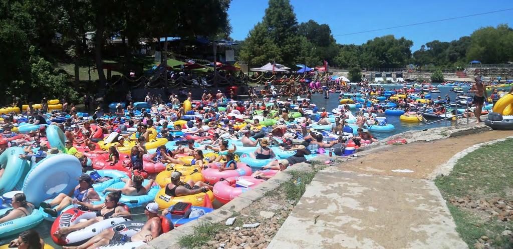
6 Observed Conditions Tube Chute Count 60 people per minute No assistance needed from staff


7 Observed Conditions Stinky Falls Count 30 people per minute With assistance from staff


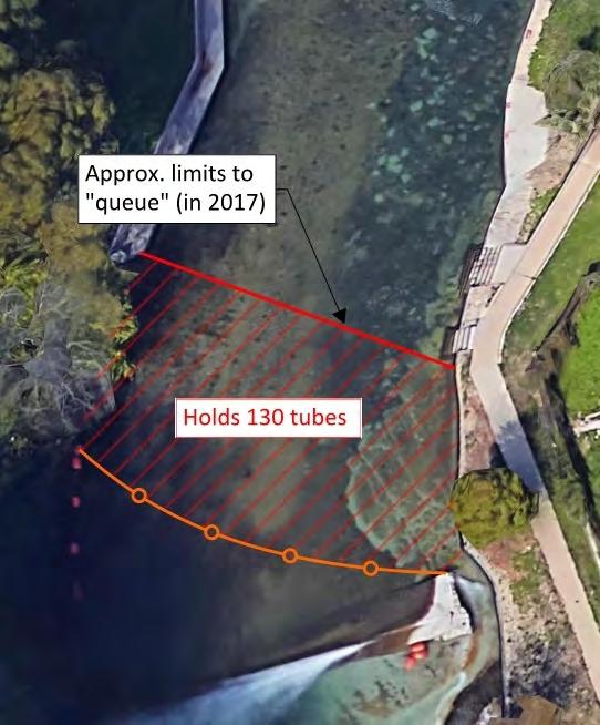
8 Observed Conditions Stinky Falls City starts queuing based on backup


9 Observed Conditions Last Public Exit Estimates Exit Platform, Stairs, and Shuttle Pickup: people per minute with assistance
: 5,805")
10 River Usage Summer 2017 Saturdays: 12,888 wristbands Sundays: 7,500 wristbands Holidays (weekdays): 5,805 wristbands
11 Key OBSERVATIONS & Recommendations


12 Observations Dam is in good condition overall Resilient to flooding Recommendations Repair erosion at abutments Tube Chute Dam

13 Chute Exit and Lifeguard Area Observations Tubes collide and flip after chute; difficultly swimming in turbulent water Lifeguard operation is critical for safety Recommendations Modify the tube chute to improve tuber safety and reduce staffing needs Improve lifeguard station to provide better separation from park users Tube Chute Park

14 Stinky Falls Weir Observations Good structural condition Backup occurs due to limited capacity Park rangers required to assist through chute and cut twine Recommendations Modify Stinky Falls weir to improve safety, increase capacity, and reduce staffing requirements Tube Chute Park


15 Tuber and Pedestrian Circulation River Access Point Observations One river access point upstream of Tube Chute No dedicated entry point downstream of Stinky Falls weir Recommendation Improve egress and ingress for pedestrians bypassing the tube chute and Stinky Falls area Tube Chute Park


16 Exit Platform Observations Good overall condition Platform only extends 2 into water and 1 below water surface Hard to reach handrails Last Public Exit

17 Exit Platform Observations Safety concerns Staff intensive to assist tubers Recommendations Extend the platform into the water to improve safety and reduce staffing requirements Last Public Exit

18 Stairs and Ramp Observations Fair overall condition Limited width due to ramps ADA access is challenging due to crossing exit path Recommendations Evaluate options to increase stairway width and improve the ADA aspect Monitor the walls Last Public Exit

19 Vehicle and Pedestrian Circulation Observations All vehicles have to use the same loop (parking, drop-offs, EMS) No sidewalks from Liberty Ave. or amenities; no direct route from San Antonio St. Recommendation Improve pedestrian safety throughout park Improve vehicular circulation Prince Solms Park


20 Queuing the River Observations Long lines create unsafe conditions in peak heat times Staff intensive to mange entrance, install line guides and water stations Prince Solms Park


21 Queuing Area Recommendation Improve the queuing area to improve tuber safety and reduce staffing requirements Queuing the River Prince Solms Park


22 Observations Confusing for users Lacks climate control for staff No direct restroom access for Prince Solms Park users Recommendation Reconfigure Tube Rental Building to be more userfriendly to park users, provide restrooms for Prince Solms Park users, and better serve staff needs Tube Rental Building Tube Chute Rental Building


23 Shaded Picnic Area River Access Point Observations Staff building for river operations team Underutilized by Tube Chute Park users Staff Building and Parking Recommendation Visioning opportunity for desired park programs Float Inn Mill Street Property


24 Observations Bank retaining walls in fair condition with some rotation and material loss Dive inspection found some voids Grass strip susceptible to erosion Recommendation Monitor the walls at regular intervals and after flood events Hinman Island Park


25 Reduce algae growth on water access stairs Incorporate resilient materials to prevent erosion on riverbank Replace stairs, sidewalks and handrails to meet code and ADA Incorporate Low Impact Development Strategies to Manage Stormwater Durango Trail and Whitewater Park Amenities Denver, Colorado All Focus Areas


26 PUBLIC ENGAGEMENT ACTIVITIES Outreach and Meetings with Stakeholders June 2018 Public Meeting July 2018 o Share summary of existing conditions o Gather feedback on recommendations o Identify initial preferences Survey July 2018 o Public meeting o On-site
27 PUBLIC ENGAGEMENT Support Help us Spread the Word! Tell people or groups about the project, and how to sign up and get involved!
MAG Town of Cave Creek Bike Study Task 6 Executive Summary and Regional Significance Report
 Page 1 MAG Town of Cave Creek Bike Study Task 6 Executive Summary and Regional Significance Report August 1, 2012 MAG Project #481 Page 2 Task 6 Executive Summary and Regional Significance Report Introduction
Marina Bay Trail Community Meeting #1
 Marina Bay Trail Community Meeting #1 AGENDA 1. Introductions: Meghan Tiernan, DPW Cristina Olea, DPW Jerry Robbins, SFMTA 2. Meeting Purpose:. 4. 5. 6. To introduce the project to the community and gather
City of Los Angeles Department of Building & Safety Disabled Access Section Supplemental Plan Review Checklist No. 8 RECREATION FACILITIES
 AMUSEMENT RIDES, BOAT SLIPS, BOWLING LANES, COURT SPORTS, FISHING PIERS Plan Check No. 1. Amusement rides required to comply with 11B-234, Amusement Rides shall provide accessible routes in accordance
George Washington Bridge Restoring the George Construction Program Supplemental Information on Bicycle and Pedestrian Access
 George Washington Bridge Restoring the George Construction Program Supplemental Information on Bicycle and Pedestrian Access The replacement of the George Washington Bridge suspender ropes is part of the
Capital Metro Downtown Multimodal Station
 Capital Metro Downtown Multimodal Station Open House December 11, 2015 Project Goals & Objectives 1 2 3 4 Address near- and long- term MetroRail operational needs Address existing safety issues and modal
Portland Peninsula Sidewalk and Ramp Inventory
 Portland Peninsula Sidewalk and Ramp Inventory Conducted June and July of 2008 By Anne Krikorian and Ryan Carmichael Performed under the authority of: Greater Portland Council of Governments And with the
Point Defiance Park. Master Plan
 Point Defiance Park Master Plan Public Participation 1/29, 2/26, 3/26 & 4/23 Owen Beach Ferry Zoo Fort Nisqually Mildred Street Pearl Street Triangle Hare & Hare Master Plan - 1911 2008 Concept Plan Comments
Iowa State Fair Special Events Management Strategic Plan
 Iowa State Fair Special Events Management Strategic Plan April 2010 Prepared for Prepared by Table of Contents 1.0 Introduction... 1 2.0 Key Event Elements... 1 2.1 Event Characteristics and Attendance...
I-35 COMAL COUNTY OPERATIONAL IMPROVEMENTS
 I- COMAL COUNTY OPERATIONAL IMPROVEMENTS OPEN HOUSE The environmental review, consultation, and other actions required by applicable Federal environmental laws for this project are being, or have been,
Canoe/Kayak Launch Sites and Accessibility
 Canoe/Kayak Launch Sites and Accessibility Doug Alderson, Paddling Trails Coordinator Division of Recreation and Parks Office of Greenways and Trails Each potential access site on a river, lake or ocean
FOLSOM-HOWARD STREETSCAPE OVERVIEW
 FOLSOM-HOWARD STREETSCAPE OVERVIEW SoMa residents should have the same kinds of amenities that other neighborhoods have. The Folsom- Howard Streetscape Project will make SoMa more livable by making it
Conceptual Design Report for the Fabri Dam Modifications Project
 Conceptual Design Report for the Fabri Dam Modifications Project Flint, Michigan Prepared For: City of Flint P.O. Box 99 Flint, MI 48501-0099 Flint River Watershed Coalition 432 N. Saginaw St. Suite 1001
COMMUNITY MEETING AGENDA
 COMMUNITY MEETING AGENDA Welcome and Introductions SAFE Presentation Project Presentation Priorities Feedback Next Steps Q&A Santa Cruz Avenue Corridor Study 1 Santa Cruz Avenue Corridor Study Community
TRAVEL PLAN: CENTRAL EUROPEAN UNIVERSITY CAMPUS REDEVELOPMENT PROJECT TRAVEL PLAN. Central European University Campus Redevelopment Project.
 TRAVEL PLAN Central European University Campus Redevelopment Project Page 1 Table of Contents Introduction... 3 Background... 7 Building Users... 7 Transportation in Community Consultation... 7 Summary
Roads and Vehicular Traffic Design Principles. Roads and Vehicular Traffic Recommendations
 CIRCULATION AND PARKING roads and vehicular traffic The Campus Master Plan updates the campus transportation network through a multi-modal approach that encourages walking and biking while improving vehicular
Ocean Park Boulevard Green Street Project Alternatives & Trade Offs
 Planning Commission March 4, 2009 Ocean Park Boulevard Green Street Project Alternatives & Trade Offs Purpose of Tonight s Meeting Review concept plans and options Provide input on alternatives and trade-offs
Minnesota Street Properties Community Workshop Planning for Design 3/17/2016
 Minnesota Street Properties Community Workshop Planning for Design Minnesota Street Properties: Community Workshop Agenda 1. Introduction 2. Analysis of previous community workshop 3. What UCSF is able
COUNCIL POLICY NAME: COUNCIL REFERENCE: 06/119 06/377 09/1C 10llC 12/1C INDEX REFERENCE: POLICY BACKGROUND
 COUNCIL POLICY NAME: COUNCIL ADVISORY COMMITTEES - TERMS OF REFERENCE ISSUED: APRIL 3, 2006 AMENDED: NOVEMBER 27, 2006 NOVEMBER 23, 2009 JANUARY 11, 2010 DECEMBER 17, 2012 POLICY COUNCIL REFERENCE: 06/119
Austin Avenue Bridges Project. Public Meeting Summary
 Austin Avenue Bridges Project Public Meeting Summary June 29, 2016 Red Table Safety and Connectivity Notes: 1. Would like to see forensic report evaluations 2. What is the lifespan? 3. Extend safety considerations
Conceptual Design Report for the Hamilton Dam Modifications Project. Flint, Michigan. Prepared For: City of Flint P.O. Box 99 Flint, MI
 Conceptual Design Report for the Hamilton Dam Modifications Project Flint, Michigan Prepared For: City of Flint P.O. Box 99 Flint, MI 48501-0099 Flint River Watershed Coalition 432 N. Saginaw St. Suite
Lincoln Highway Streetscape Plan Concept Plan
 Lincoln Highway Streetscape Plan Concept Plan November 14, 2014 Introduction This report provides a summary of conceptual transportation, land use, and design recommendations in the Lincoln Highway Streetscape
Kennesaw Mountain National Battlefield Park Mountain Road Alternatives
 Kennesaw Mountain National Battlefield Park Mountain Road Alternatives Management Issue Kennesaw Mountain National Battlefield Park was established by Congress in 1935 to preserve and commemorate the site
WHITE STREET/ ENGLISH PLAZA STREETSCAPE IMPROVEMENT PROJECT
 WHITE STREET/ ENGLISH PLAZA STREETSCAPE IMPROVEMENT PROJECT 1 Project Goals 1 Improved Safety: Lighting, Multi-Modal Circulation, Emergency Access, Tripping Hazards; Stormwater 4 Environmental Performance:
Maywood Town Hall Meeting. May 4, 2016
 Maywood Town Hall Meeting May 4, 2016 1 AGENDA Overall I-290 Study Background Maywood Advisory Working Group (AWG) findings to date Noise Wall Update Next Steps 2 Questions? Study team members also available
Make Lincoln Highway an economically vibrant corridor that is safe, efficient, and beautiful for local residents and visitors.
 Lincoln Highway Streetscape Plan Stakeholder Workshop #2 Handout Contents Introduction and Project Vision Planning Principles Specific Recommendations including a Proposed Typical Roadway Section Renderings
Memo. Ocean Avenue Corridor Design Project Public Workshop #2 Summary
 Ocean Avenue Corridor Design Project Public Workshop #2 Summary The second public workshop for the Ocean Avenue Corridor Design Project was held on Wednesday, May 14, 2014 from, 6 to 8 pm at Lick Wilmerding
Existing Clubhouse Issues - Non-Spatial PRELIMINARY
 Pedestrian/ Public conflict with beach operations F Public Boatshed IRB/ ATV Patrol Gear Board & Ski Nippers First Aid F Change Beach entry CS3 Gym M Change Lift G Lifeguards timber fire stair nearing
EXECUTIVE SUMMARY Callan Park accommodates travel from a wide range of transport modes, including walking, cycling, bus and light rail.
 TRANSPORT AND ACCESS EXECUTIVE SUMMARY Callan Park accommodates travel from a wide range of transport modes, including walking, cycling, bus and light rail. Whilst there are some walking facilities within
Broad Street Bicycle Boulevard Design Guidelines
 Broad Street Bicycle Boulevard Design Guidelines Building from the strategies introduced in the 2013 Bicycle Transportation Plan and community input received thus far, City Transportation Staff have identified
North Shore Transportation Improvement Strategy
 North Shore Transportation Improvement Strategy Preliminary, Near-term Recommendation 2016 April Transportation Improvement Strategy (TIS) Comprehensive and Analytical A multi-modal transportation strategy
Elmhurst Metra Station. Public Hearing Wednesday - November 30, 2016
 Elmhurst Metra Station Public Hearing Wednesday - November 30, 2016 Agenda Introduction to Hearing Format - Presentation (20 Minutes) - Exhibits/Workstations - Record (Comment Cards, Court Reporter)
Niantic Center Elementary School
 Niantic Elementary School is located in the Northwest corner of the intersection of West Main Street and East Pattagansett Road, as so noted on the Facility Location Map. location Overview: The site is
CONNECTING PEOPLE TO PLACES
 CONNECTING PEOPLE TO PLACES 82 EAST BENCH MASTER PLAN 07 Introduction The East Bench transportation system is a collection of slow moving, treelined residential streets and major arteries that are the
Community Task Force November 15, 2017
 Community Task Force November 15, 2017 Welcome and Introductions Project Partners Regional Transportation District (RTD) Colorado Department of Transportation (CDOT) Denver Regional Council of Governments
Philip A. Ginsburg, General Manager Dawn Kamalanathan, Director of Capital and Planning Division
 Date: August 17, 2017 To Through From Subject: Recreation and Park Commission Philip A. Ginsburg, General Manager Dawn Kamalanathan, Director of Capital and Planning Division Toks Ajike, Project Manager,
Technical Working Group November 15, 2017
 Technical Working Group November 15, 2017 Welcome and Introductions Project Partners Regional Transportation District (RTD) Colorado Department of Transportation (CDOT) Denver Regional Council of Governments
CHAPTER 3: Vision Statement and Goals
 Davidson Walks & Rolls: Active Transportation Master Plan CHAPTER 3 Contents: Overview Vision Statement Measurable Goals Public Outreach CHAPTER 3: Vision Statement and Goals Overview The vision statement
Princeton Avenue and Spruce Street Transportation and Site Access Enhancements Project
 Princeton Avenue and Spruce Street Transportation and Site Access Enhancements Project Mercer County Planning Division AECOM Transportation (formerly DMJM Harris) January 29, 2009 Agenda Project Status
Thank you for attending
 Improving mobility safety comfort WELCOME Thank you for attending The purpose of this meeting is to: Learn about the project Prioritize potential walking and biking improvements on Snelling Ave Gather
Public Meeting #1 Comment Summary
 Public Meeting #1 Comment Summary This summary includes comments received on comment forms and during conversations between attendees and project team staff at the February 18, 2016 public open house.
Washington Park Loop Road Safety Planning Recommendations
 Washington Park Loop Road Safety Planning Recommendations PUBLIC MEETING December 10, 2014 Issues To be Considered Summary 1. Most users are happy with the loop road but some users do not follow the rules
Reference: Laguna Canyon Road Traffic Conditions Data Collection Summary
 Stantec Consulting Services Inc. 38 Technology Drive Suite 100, Irvine CA 92618-5312 September 8, 2017 File: 2073014320 Attention: Mark Trestik, Assistant City Engineer City of Beach Department of Public
Earthen Embankments. turning into larger, more costly repairs. The following. The State Dam Safety Program has inspection
 TOPIC: COMMON PROBLEMS FOR SMALL DAMS WITH CONCRETE CHANNEL SPILLWAYS The State Dam Safety Program has inspection requirements for state regulated dams. A dam, like any man-made structure, will change
CONCEPTUAL PLANNING REPORT CONCEPTUAL MASTER PLAN WHITEWATER COURSE BARREN RIVER BOWLING GREEN, KENTUCKY
 CONCEPTUAL PLANNING REPORT CONCEPTUAL MASTER PLAN WHITEWATER COURSE BARREN RIVER BOWLING GREEN, KENTUCKY PREPARED BY: RECREATION ENGINEERING AND PLANNING 485 ARAPAHOE AVE. BOULDER, CO 80302 303-545-5883
Pennsylvania Avenue (CR 484) Design Alternatives Study
 Design Alternatives Study") MEMORANDUM Pennsylvania Avenue (CR 484) Design Alternatives Study Prepared for: APRIL 2016 Prepared By TABLE OF CONTENTS Project Background... 2 Previous Concept... 2 Existing Conditions... 4 New Alternatives...
MEMORANDUM Pennsylvania Avenue (CR 484) Design Alternatives Study Prepared for: APRIL 2016 Prepared By TABLE OF CONTENTS Project Background... 2 Previous Concept... 2 Existing Conditions... 4 New Alternatives...
TRANSPORTATION & MOBILITY
 TRANSPORTATION & MOBILITY ROADWAY SYSTEM There are approximately 40 miles of roadways in Manitou Springs. For planning purposes, roadways are typically assigned a functional classification which defines
Bicycle-Pedestrian Master Plan: Chapters 3 and 4 Distribution
 Bicycle-Pedestrian Master Plan: Chapters 3 and 4 Distribution Finksburg Planning and Citizens Council March 22, 2018 Overview Progress Citizen Outreach Vision Chapter 3 - Existing Conditions Chapter 4
Watertown Complete Streets Prioritization Plan. Public Meeting #1 December 14, 2017
 Watertown Complete Streets Prioritization Plan Public Meeting #1 December 14, 2017 Goals for Public Meeting Overview of MassDOT Complete Streets Funding Program Educate the community on Complete Streets
Bikeway action plan. Bicycle Friendly Community Workshop March 5, 2007 Rochester, MN
 Bikeway action plan Summary The was held on March 5, 2007 at the Rochester Mayo Civic Center. The workshop was hosted by Rochester-Olmsted County Planning Department in collaboration with the League of
Ottawa Beach Road Study
 Ottawa Beach Road Study Prepared For: Park Township September 30, 2014 Project No. G140303 OTTAWA BEACH ROAD STUDY PREPARED FOR: PARK TOWNSHIP SEPTEMBER 30, 2014 PROJECT NO. G140303 TABLE OF CONTENTS 1.0
KEARNY MESA COMMUNITY PLAN UPDATE
 KEARNY MESA COMMUNITY PLAN UPDATE January 18, 2018 SUBCOMMITTEE MEETING Mobility Concepts and Urban Design Presentation Outline Mobility Concepts: Multimodal Planning Toolbox Presentation and Activities
newly constructed and altered recreation facilities guidelines for newly constructed and altered buildings and facilities subject to the ADA.
 1 Americans with Disabilities Act Accessibility Guidelines Recreation Facilities 2 Final Rule Federal Register September 3, 2002 3 Architectural and Transportation Barriers Compliance Board 36 CFR Part
Appendix B - Street Sections
 Appendix B - Street Sections 6TH STREET CORRIDOR PLAN STREET SECTIONS The street sections in Appendix B include recommended improvements to streets for North Glenwood. They include existing conditions
SAN FRANCISCO MUNICIPAL TRANSPORTATION AGENCY
 THIS PRINT COVERS CALENDAR ITEM NO. : 11 DIVISION: Sustainable Streets BRIEF DESCRIPTION: SAN FRANCISCO MUNICIPAL TRANSPORTATION AGENCY Approving traffic modifications on Twin Peaks Boulevard between Christmas
15 April CAMPUS MASTER PLAN UPATE F o c us G r o up M o b ility
 15 April 2016 CAMPUS MASTER PLAN UPATE F o c us G r o up M o b ility AGENDA What We Heard Campus Framework & Open Space Network Mobility Approach Supporting the Pedestrian Environment Mobility & Sustainability
South False Creek Seawall Park Upgrades & Tree Replacements
 South False Creek Seawall Park Upgrades & Tree Replacements PARK BOARD COMMITTEE MEETING May 2, 2016 Recommendations A. THAT the Vancouver Park Board approve the design plan for the South False Creek Seawall
CONNECTIVITY PLAN. Adopted December 5, 2017 City of Virginia Beach
 CONNECTIVITY PLAN Adopted December 5, 2017 City of Virginia Beach CONTENTS 1.0 Background & Purpose... 2 2.0 Existing Inventory & Analysis... 3 ViBe District Existing Walking Conditions... 4 3.0 ViBe District
Technical Report & Design Concepts. January 2018
 Technical Report & Design Concepts January 2018 Table of Contents Introduction 1 Recap of Existing Conditions 1 Developing Design Concepts 2 Criteria for the Concepts 3 What If We Do Nothing? 6 Preliminary
50 Avenue S.W. Corridor Study Glenmore Aquatic Centre Drop-In Event
 Project overview The City of Calgary is conducting a transportation corridor study of 5 Avenue S.W., between Crowchild Trail and 4A Street S.W. In 29, it was reclassified as a Parkway under the Calgary
I-290 Phase I Study Area OAK PARK AVE AUSTIN BLVD. Reconstruction Area (9 miles) Oak Park RIDGELAND AVE CENTRAL AVE HARLEM AVE. Cicero.
 Oak Park RIDGELAND AVE CENTRAL AVE HARLEM AVE. Cicero.") RIDGELAND AVE OAK PARK AVE AUSTIN BLVD UP-RR BRC-RR ASHLAND AVE Study Area Map I-290 Phase I Study Area 294 UP RR Metra UP-W Illinois Prairie Path 38 Berkeley WOLF RD Hillside MANNHEIM RD Bellwood 290
RIDGELAND AVE OAK PARK AVE AUSTIN BLVD UP-RR BRC-RR ASHLAND AVE Study Area Map I-290 Phase I Study Area 294 UP RR Metra UP-W Illinois Prairie Path 38 Berkeley WOLF RD Hillside MANNHEIM RD Bellwood 290
CITY OF BLOOMINGTON COMPLETE STREETS POLICY
 CITY OF BLOOMINGTON COMPLETE STREETS POLICY POLICY OBJECTIVE: The City of Bloomington will enhance safety, mobility, accessibility and convenience for transportation network users of all ages and abilities,
Trip Generation for an averaged sized elementary school in Provo, Utah
 Trip Generation for an averaged sized elementary school in Provo, Utah Brigham Young University s ITE student chapter conducted a Trip Generation Study to determine the number of trips generated by an
CITY MANUALS AND STANDARDS REVIEW
 GEORGETOWN SIDEWALK MASTER PLAN CITY MANUALS AND STANDARDS REVIEW RESOURCES AND STANDARDS As part of the Master Plan process, a review and evaluation of current City documents and policies relevant to
Field guide for Accessible Public Rights-of-Way Edition
 Field guide for Accessible Public Rights-of-Way 2015 Edition BRIEFING MEMO SUBJECT: Department of Justice/Department of Transportation Joint Technical Assistance on Title II of the Americans with Disabilities
Sherwood Drive Traffic Circle
 Strathcona County Sherwood Drive Traffic Circle Online Survey Results April 7, 215 I. Executive Summary The Sherwood Drive Traffic Circle Survey was administered in March 215. In total, 2,263 residents
COWETA HIGH SCHOOL AND EAST HIGHWAY 51
 COWETA HIGH SCHOOL AND EAST HIGHWAY 51 Lack of sidewalks along Ben Lumpkin Rd. Lack of crosswalks and ramps at intersection. Hwy 51 is wide to cross as a pedestrian. No ADA compliance or connection to
BUFORD HIGHWAY TRANSPORTATION STUDY: FINAL REPORT City of Suwanee, Georgia April, 2010
 BUFORD HIGHWAY TRANSPORTATION STUDY: FINAL REPORT City of Suwanee, Georgia April, 2010 www.urscorp.com phone.678.808.8800 fax. 678.808.8400 Final Report Prepared for: 330 Town Center Avenue Suwanee, Georgia
California Conference of Directors of Environmental Health Recreational Health Technical Advisory Committee September 17, 2003
 California Conference of Directors of Environmental Health Recreational Health Technical Advisory Committee September 17, 2003 RECREATIONAL WATER PARKS GUIDELINES Definitions. ACTIVITY POOL means a pool
Washington State University Bicycle and Pedestrian Plan Working Paper #7: Implementation Strategies
 nnn Washington State University Bicycle and Pedestrian Plan nnn TO: Bridgette Brady, CAPP, Director Parking and Transportation Services FROM: Alta Planning Design DATE: November 2013 Introduction As described
Androscoggin River Trail Access Sites. Mahoosucs. 168 miles from its source at Lake Umbagog to Merrymeeting Bay
 Androscoggin River Trail Access Sites Mahoosucs 168 miles from its source at Lake Umbagog to Merrymeeting Bay Trail Under Construction More than 40 Public Access Sites Available Androscoggin River Watershed
Exhibit 1 PLANNING COMMISSION AGENDA ITEM
 Exhibit 1 PLANNING COMMISSION AGENDA ITEM Project Name: Grand Junction Circulation Plan Grand Junction Complete Streets Policy Applicant: City of Grand Junction Representative: David Thornton Address:
Community Meeting: Proposed Development 4520 Penn Ave. Notes January 30, :30-8:30pm
 Community Meeting: Proposed Development 4520 Penn Ave. Notes January 30, 2017 6:30-8:30pm Attendance: 17 community members Welcome and Introductions- Christina Howell Christina introduced herself as the
Levitt Pavilion at Ruby Hill Park. Public Meeting #2 September 27, 2016
 Levitt Pavilion at Ruby Hill Park Public Meeting #2 September 27, 2016 Welcome/ Introductions Purpose of the meeting Public Meeting #2 September 27, 2016 Community Garden Mountain Bike Park Basketball
CITY OF LOS ANGELES INTER-DEPARTMENTAL MEMORANDUM
 CITY OF LOS ANGELES INTER-DEPARTMENTAL MEMORANDUM Date: April 1, 219 To: Honorable City Council c/o City Clerk, Room 395, City Hall Attention: Honorable Mike Bonin, Chair, Transportation Committee From:
Richmond-Adelaide Cycle Tracks
 Public Drop-In Event Richmond-Adelaide Cycle Tracks June 25, 2018 12:00 p.m. 3:00 p.m. 4:30 p.m. 7:30 p.m. Metro Hall, Rotunda 55 John Street 1 Purpose of Event In Scope Communicate an update about the
YELLOWHEAD TRAIL / 149 STREET INTERCHANGE
 YELLOWHEAD TRAIL / 149 STREET INTERCHANGE WELCOME Today we are introducing the concept planning project for a new gradeseparated interchange at Yellowhead Trail and 149 Street PURPOSE Provide information
Orange Center Elementary School
 Drag and drop pic and stretch/crop to the limits of the blue rectangle (delete this text box) Orange Center Elementary School Drag and drop pic and stretch/crop to the limits of the blue rectangle (delete
Bicycle Master Plan Goals, Strategies, and Policies
 Bicycle Master Plan Goals, Strategies, and Policies Mobilizing 5 This chapter outlines the overarching goals, action statements, and action items Long Beach will take in order to achieve its vision of
42nd Ave N Reconstruction
 CITY OF MINNEAPOLIS 42nd Ave N Reconstruction Community Meeting #2 May 2016 6:00 7:30 p.m. 5/16/2016 1 Purpose of Meeting Inform: Provide an overview of project, identify anticipated scope of work, and
Crawford Reservoir. FISH SURVEY AND MANAGEMENT INFORMATION Eric Gardunio, Fish Biologist Montrose Service Center
 FISH SURVEY AND MANAGEMENT INFORMATION General Information: Crawford Reservoir is a popular fishery that provides angling opportunity for yellow perch, channel catfish, northern pike, rainbow trout, black
WELCOME. Stakeholder Involvement Group Meeting #2 Round Lake Public Works October 24, 2018
 WELCOME Stakeholder Involvement Group Meeting #2 Round Lake Public Works October 24, 2018 MEETING AGENDA 1. Welcome and Introductions 2. Study Progress Update 3. Problem Statement 4. Technical Analysis
Proposed Amendment to the City-Wide Trails Plan
 Proposed Amendment to the City-Wide Trails Plan Planning and Zoning Commission June 23, 2015 Comprehensive Plan 2010 Sustainable Community Recommendations 2 Goal: Walking and Cycling are Encouraged throughout
INTEGRATED ACCESSIBILITY STANDARDS REGULATION. Training Module for the Design of Public Spaces Standard
 INTEGRATED ACCESSIBILITY STANDARDS REGULATION Training Module for the Design of Public Spaces Standard DISCLAIMER This training resource provides an overview of Part IV.1 of the Integrated Accessibility
Off-road Trails. Guidance
 Off-road Trails Off-road trails are shared use paths located on an independent alignment that provide two-way travel for people walking, bicycling, and other non-motorized users. Trails specifically along
RECORD OF PROCEEDINGS MINUTES OF A REGULAR MEETING OF THE BOARD OF DIRECTORS OF SANTA FE BUSINESS IMPROVEMENT DISTRICT
 RECORD OF PROCEEDINGS MINUTES OF A REGULAR MEETING OF THE BOARD OF DIRECTORS OF SANTA FE BUSINESS IMPROVEMENT DISTRICT HELD: Tuesday, April 28, 2015 at 4:00 pm at 901 W. 10th Ave., Unit 2A, Denver, Colorado.
See Figure 38, Existing Nonmotorized Connections.
 Nonmotorized Connections Existing Nonmotorized Connections Pedestrian, vehicle and bike traffic access and movements are confined primarily to Penny Drive on campus. Due to the steep slope along the length
Drag and drop pic and stretch/crop to the limits of the blue rectangle (delete this text box) Maxey Elementary School
 Maxey Elementary School") Drag and drop pic and stretch/crop to the limits of the blue rectangle (delete this text box) Maxey Elementary School SCHOOL ROUTE PLAN For MAXEY ELEMENTARY SCHOOL LOCATION 33 ORANGE COUNTY Prepared for:
Drag and drop pic and stretch/crop to the limits of the blue rectangle (delete this text box) Maxey Elementary School SCHOOL ROUTE PLAN For MAXEY ELEMENTARY SCHOOL LOCATION 33 ORANGE COUNTY Prepared for:
CHAPTER 5: GENERAL SITE AND BUILDING ELEMENTS
 CHAPTER 5: GENERAL SITE AND BUILDING ELEMENTS 501 General 501.1 Scope. The provisions of Chapter 5 shall apply where required by Chapter 2 or where referenced by a requirement in this document. 502 Parking
VIRGINIA RAILWAY EXPRESS
 PREPARING FOR THE NEXT QUARTER-CENTURY Arlington County Board Work Session June 28, 2017 1 TODAY S PRESENTATION VRE Overview VRE in Arlington County VRE System 2040 Plan Future Vision for Crystal City
Community Task Force March 14, 2018
 Community Task Force March 14, 2018 Welcome and Introductions Project Partners Regional Transportation District (RTD) City of Aurora Colorado Department of Transportation (CDOT) Denver Regional Council
Wine Barrels, Straw Wattle, and Elbow Grease: Playing Around with Monterey Road Joshuah Mello, AICP Senior Associate
 Wine Barrels, Straw Wattle, and Elbow Grease: Playing Around with Monterey Road Joshuah Mello, AICP Senior Associate Context Downtown Morgan Hill Timeline of Project 1. Funding must be used! 2. Complete
RECOMMENDED MOTION: I MOVE TO PASS SECOND READING AND ADOPT ORDINANCE 556, TO REMOVE NE 173RD STREET FROM THE DESIGNATED PEDESTRIAN-ORIENTED STREETS.
 CITY OF WOODINVILLE, WA REPORT TO THE CITY COUNCIL 17301 133rd Avenue NE, Woodinville, WA 98072 wvvw.ci.woodinville.wa.us To: Honorable City Council Date: 02/05/2013 From: Richard A. Leahy, City Manager
CHAPTER X: PORTAGES AROUND DAMS
 CHAPTER X: PORTAGES AROUND DAMS A. General Description Portages are land routes used by paddlers to transport their boats to and from a launch area or between access sites. Often located along water bodies
Main-McVay Transit Study: Phase 2 Options Definition and High Level Constraints Evaluation
 Main-McVay Transit Study: Phase 2 Options Definition and High Level Constraints Evaluation APRIL 2016 A collaborative study between: For Additional Information or to Comment If you would like additional
Tonight is for you. Learn everything you can. Share all your ideas.
 Strathcona Neighbourhood Renewal Draft Concept Design Tonight is for you. Learn everything you can. Share all your ideas. What is Neighbourhood Renewal? Creating a design with you for your neighbourhood.
Franklin Boulevard Traffic Calming Study. Public Meeting #1 October 11, 2017
 Franklin Boulevard Traffic Calming Study Public Meeting #1 October 11, 2017 Agenda Welcome and Introductions Project Overview Potential Improvements Map Exercise Report Out NOACA Technical Assistance (TA)
Healthy Hospitals Physical Activity Scan * Required
 * Required 1. Rater ID * Insert here the ID# you were assigned for the project 2. Hospital ID * Insert here the ID# for the hospital you are scanning today Page 1 of 15 3. Hospital Name * 4. Scan Date
Providing an Efficient and Multi-modal Transportation System
 Providing an Efficient and Multi-modal Transportation System Welcome and Introductions The Plan Process Transportation Overview Workshop Discussions Report Out and Next Steps AGENDA Comprehensive Plan
QUILCENE COMPLETE STREETS - SITE ANALYSIS PAVED IN RIGHT-OF-WAY GRAVEL IN RIGHT-OF-WAY STRUCTURES
 US BANK PENINSULA FOODS QUILCENE THEATRE POST OFFICE QUILCENE COMMUNITY CENTER LANDSCAPE IN RIGHT-OF-WAY RIGHT-OF-WAY PAVED IN RIGHT-OF-WAY GRAVEL IN RIGHT-OF-WAY STRUCTURES QUILCENE COMPLETE STREETS -
Project Launch Community Meeting 1 Summary
 ConsumersNext: Planning for People and Business at Sheppard and Victoria Park Project Launch Community Meeting 1 Summary Participants Listening to the Overview Presentation Prepared for the City of Toronto