Agassiz Road Back Bay Fens Boston, Massachusetts
|
|
|
- Irma Harper
- 6 years ago
- Views:
Transcription
1 Conceptual Design Report Agassiz Road Back Bay Fens Boston, Massachusetts March 2012 Massachusetts Department of Conservation and Recreation Bureau of Planning and Resource Protection In partnership with Fenway Civic Association Report prepared by Pressley Associates, Inc., Cambridge, Massachusetts VHB, Inc., Boston, Massachusetts
2 THISPAGEINTENTIONALLYBLANK
3 Mission:Toprotect,promote,andenhanceourcommonwealthof natural,culturalandrecreationalresources. TheMassachusettsDepartmentofConservationandRecreation(DCR)isastewardtoover 450,000acresthroughoutMassachusetts.FormoreinformationontheDCRandthe MassachusettsStateParksystemvisit, DCR 251CausewayStreet Boston,MA FundingsupportforthisreportwasprovidedbytheFenwayCivicAssociation(FCA) anddcr spartnershipmatchingfundsprogram. DevalL.Patrick,Governor TimothyP.Murray,Lt.Governor RichardK.Sullivan,Jr.,Secretary,EOEEA EdwardM.Lambert,Jr.,Commissioner,DCR AllphotosbyPressleyAssociatesunlesswherenoted.
4 THISPAGEINTENTIONALLYBLANK
5 Conceptual Design Report Agassiz Road Back Bay Fens Boston, Massachusetts CONTENTS Introduction 1 History of Agassiz Road 3 Existing Site Conditions 7 Transportation Analysis 11 Conceptual Design Options 13 Option A Maintain Existing Roadway Width Option B Reduced Roadway Width Option C - Reduced Roadway with Landscape Strips Crosswalks Preferred Conceptual Design Option 17 Roadway Cross Section Bicycle Lanes Roadway Intersections Pathways and Crosswalks Queensberry Street Intersection Order of Magnitude Cost Estimate List of Photographs and Figures 1. Bing Maps aerial photograph of Agassiz Road and surrounding areas 1 2. Birdseye view of Agassiz Road 2 3. Approximate DCR jurisdictional limits 2 4. Map of the Back Bay Fens (1887) 3 5. Close-up of Figure Back Bay Fens and Vicinity Survey (1921) 4 7. Circa early 1900 s photograph at the intersection of Agassiz Road with Park Drive 4 8. Cross-sectional view of the original design of Agassiz Road 5 9. Bing Maps aerial photograph of Agassiz Road Agassiz Road and adjacent pathway, looking west Catch basin inlet demarking old roadway width Cross section of existing Agassiz Road 8 March 2012
6 Contents Emerald Necklace Parks Crosswalk and Pathway Treatment Guidelines 13. Cross section of existing Agassiz Road at Bridge Locations of existing designated crosswalks Intersection of Queensberry Street and Park Drive Typical light pole and fixture along Agassiz Road Typical light pole and fixture along Agassiz Road Option A cross section Maintain Existing Roadway Width Option B cross section Reduced Roadway Width with Bike Lane Option C cross section Reduced Roadway Width with Bike Lane and Landscape Strips Diagram of existing crosswalks and conceptual locations for proposed new crosswalks Existing Conditions at Queensberry Street and Agassiz Road intersections Proposed conceptual plan for new crosswalks and curblines Conceptual design options voting board from October 3, 2011 meeting Preferred Conceptual Design Option cross section Preferred Conceptual Design Option plan Existing conditions at Fenway intersection Preferred Conceptual Design Option plan at Fenway intersection Existing conditions at Park Drive/Agassiz Road intersection Preferred Conceptual Design Option plan at Park Drive/ Agassiz Road intersection Existing conditions at Park Drive/Queensberry Street intersections Preferred Conceptual Design Option plan at Park Drive/Queensberry Street intersections 21 Appendices 25 Existing Conditions Plan Preferred Conceptual Design Option Plan Public Meeting Presentations March 2012

7 Agassiz Road Conceptual Design Introduction Agassiz Road is a short but historically-significant roadway under the jurisdiction of the Department of Conservation and Recreation (DCR). The road serves as an important multi-modal corridor and connector within the Back Bay Fens and the Fenway neighborhood of Boston, but the current configuration has proven inadequate for pedestrians, bicyclists, and other non-vehicular users. The wide roadway encourages vehicular speeds that are higher than the speed limit and may affect the safety of other users. In addition, there is a current movement to seek new uses for historic Duck House, a former restroom building located along the road. With a need to address these issues, the DCR and Fenway Civic Association (FCA) started the Agassiz Road Conceptual Design project in Spring 2011 with the main goal of enhancing the use, safety, and functionality of the Agassiz Road roadway, pathways, and landscape for all users. With Pressley Associates, Inc. and VHB, Inc. serving as the project design consultants, this report briefly describes the site s history and existing conditions and fully details the conceptual design process. This serves as a companion piece to the Agassiz Road Site History and Existing Conditions Report, November 2011, which describes the site s important history and current settings in more detail. The conceptual design described herein builds upon the Emerald Necklace Crosswalk and Pathway Treatment Guidelines currently being prepared by Pressley Associates for the DCR and Emerald Necklace Conservancy. Along with the main project goal, the following objectives were established in preparing the conceptual design: Enhance facilities for multiple modes of use Maximize safety and minimize conflicts for all users Integrate parkway into parkland Improve neighborhood connections Improve landscape aesthetics Incorporate pathway and crosswalk treatment guidelines Project Context Agassiz Road is located in the northern part of the Back Bay Fens, roughly between Boylston Street and Charlesgate to the north and the Museum of Fine Arts and Clemente Field to the south. Other nearby park elements include the Victory Gardens and Fire Alarm Building, north of the road, and the Rose Garden and War Memorials, south of the road. As one of the few pedestrian and bicycle corridors over the Muddy River in the Back Bay Fens, Agassiz Road connects many residential, institutional, commercial, and cultural areas of the Back Bay and the East and West Fenway neighborhoods.. Figure 1 Bing Maps aerial photograph of Agassiz Road and surrounding areas March
, the DCR mai")

8 Agassiz Road Conceptual Design Figure 2 Birdseye view of Agassiz Road (Bing Maps) Whereas the majority of the Back Bay Fens is under the jurisdiction of the Boston Parks and Recreation Department (BPRD), the DCR maintains jurisdiction over the historic parkways and parkway right of ways, including Agassiz Road. The Back Bay Fens (a.k.a. the Fens ) is part of a much larger system of parklands in Boston and Brookline known as the Emerald Necklace, stretching from the Boston Common and Public Garden to the Arnold Arboretum and Franklin Park. The central element within the Fens is the Muddy River that spills into the Charles River at Charlesgate. The Muddy River, originally a fluctuating tidal estuary, is now fresh water stream that begins downstream of Jamaica Pond. On its way to the Charles River, the Muddy River flows under a portion of Agassiz Road via the historic Agassiz Road Bridge. The outer boundary of the Fens is defined by two parkways, the Fenway and Park Drive. Agassiz Road serves as a connector road between these parkways and the west and east sides of the Fens. DCR jurisdictional limits are defined in the Fens as the back edge of the immediate sidewalks and pathways along Agassiz Road, Park Drive, and Fenway. As such, the width of this jurisdictional right of way can vary based on the location of the sidewalk/pathway. Along Agassiz Road, this jurisdictional limit is approximately 50 to 55 feet wide based on the current sidewalk/pathway locations. Figure 3 Approximate DCR jurisdictional limits (blue dashed line) for Agassiz Road, Park Drive, and Fenway (background from Bing Maps). 2 March 2012


9 Agassiz Road Conceptual Design History of Agassiz Road Based on known, published plans, Agassiz Road was always a part of the original Frederick Law Olmsted plan for the Fens. Agassiz Road, the Agassiz Road Bridge, and Duck House were constructed in the late 1800 s at the same time as the construction of the Back Bay Fens and have been features within the park that remain to the present day. The Olmsted firm put much thought into the alignment and topographical relationship of Agassiz Road to the remainder of the park. But as evidenced in historic plans and photographs, the design and flow of Agassiz Road and the intersections with Fenway and Park Drive have been altered in the course of the past 125 years, although not nearly as much as other parts of the Back Bay Fens. The major change to Agassiz Road occurred in the 1970 s with a narrowing of the roadway and the conversion from a two-way to one-way vehicular system, along with Park Drive and Fenway, and the resulting reconfiguration of the intersections. Figure 4 Map of the Back Bay Fens (Frederick Law Olmsted for the City of Boston Park Department, 1887) Figure 5 Close-up of Figure 4 March
, Figure 8 is a representative cross-sectional view of the historic Agassiz Road, showing an")

 Figure 7 Circa early 1900 s photograph at the")
10 Agassiz Road Conceptual Design Figures 6 and 7 serve as a record of the as-built condition reflective of the original Olmsted design. Drawing from the November 1921 survey (Figure 6), Figure 8 is a representative cross-sectional view of the historic Agassiz Road, showing an approximately 35-feet wide, two-way roadway with 10-feet wide pathways on the immediate sides of the roadway. The historic roadway profile is therefore 55-feet wide, matching the width between the upper walls of the Agassiz Road Bridge. This reinforces the idea that the roadway and bridge were designed much in tandem with one another. Figure 6 Back Bay Fens and Vicinity Survey (City of Boston Park Department, November 1921) Figure 7 Circa early 1900 s photograph at the intersection of Agassiz Road with Park Drive, looking east down Agassiz Road. (Boston Public Library Print Room) 4 March 2012
11 Agassiz Road Conceptual Design Figure 8 Cross-sectional view of the original design of Agassiz Road, looking west (Pressley Associates) For the better part of the 1900s, the Back Bay Fens parkways became a more important part of the regional transportation system and with this, growing amounts of vehicular traffic. With the completion of the Bowker Overpass at the Charlesgate area of the park in 1964, traffic volumes dramatically increased on the Fens parkways, providing a high speed connection to Storrow Drive and other parts of the city. In 1975, the Metropolitan District Commission (MDC), predecessor to the DCR, and BPRD reviewed the ParkPass program that was initiated by the Fenway Project Area Committee. This bold program proposed the moving of through traffic and commuter traffic off of the parkways and onto nearby arterial roadways. The Boston Redevelopment Authority (BRA) expanded on the ParkPass program and undertook a Fenway Circulation Study in The BRA figured that by redirecting traffic onto Boylston Street through intersection modifications and signal changes, the parkway vehicle counts could be dramatically reduced. One option in the BRA plan even called for converting Agassiz Road into a pedestrian-only route. But when the plans were advanced to construction, Agassiz Road remained as a vehicular road with a modified circulation pattern. Agassiz Road, as well as portions of Park Drive and Fenway, were all narrowed in width and converted into one-way traffic systems. In addition to narrowing the roadways, parallel parking along Park Drive was also eliminated and the formerly paved areas were converted into parkland. At Park Drive and Fenway, parking was redirected to the outer border parkway access roads where it remains today, although a portion of parallel parking still exists on the east side of the Fenway. Following the 1970 s reconstruction, the BRA s analysis was confirmed and traffic counts were reduced by at least half, with significant drops along Park Drive and Agassiz Road. The configuration of Agassiz Road, connecting roadways, and surrounding paths and landscape has not dramatically changed since this major reconstruction. While traffic conditions may have improved, pathway widths along Agassiz Road were actually reduced to only six-feet wide. March
12 Agassiz Road Conceptual Design 6 March 2012

 and a")
, Agassiz Road does not fulfill any function as a public transit route.")
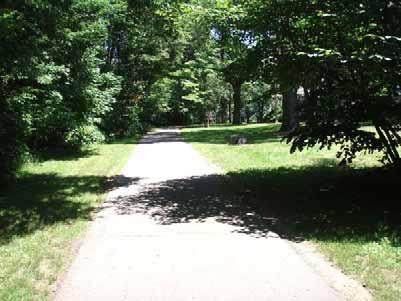
13 Agassiz Road Conceptual Design Existing Site Conditions Pressley Associates conducted an on-site field review on May 25, 2011 to document the existing crossing areas and pathway conditions. These existing conditions are more fully detailed in the Agassiz Road Site History and Existing Conditions Report, November Figure 9 Bing Maps aerial photograph of Agassiz Road Agassiz Road is approximately 840 feet long running in a gently curving west-east alignment and connecting Park Drive to Fenway. The roadway accommodates one-way vehicular traffic in an eastbound direction and, therefore, is connected to the wider roadway network by only a left turn off Park Drive (one-way southbound) and a left-turn onto Fenway (one-way northbound) controlled by a stop sign. As the size and type of vehicles allowed to use Park Drive and Fenway are restricted (including prohibition of buses), Agassiz Road does not fulfill any function as a public transit route. As noted previously, Agassiz Road was narrowed in the 1970 s to its current width of approximately 19 feet from curb to curb. The line striping on Agassiz Road is limited to worn, solid white lines offset 1 foot from the curblines. There are no designated bike lanes. The sloped granite curb along both sides of the road have a three-to-fourinch reveal. The Agassiz Road roadway and curbing are in generally good to fair condition, but the sloped curbing allows vehicles to easily jump the curb allowing vehicular parking along the sides of Agassiz Road, even though parking is not technically allowed. There is, however, residential, parallel parking on the frontage/service roads of both Park Drive and Fenway, with some parallel parking also allowed on the main Fenway roadway across from the Agassiz Road intersection. Sidewalks along both sides of Agassiz Road are paved with concrete and are approximately 6 feet wide. They connect to existing concrete, bituminous concrete, and stonedust sidewalks and pathways at the Park Drive and Fenway intersections. The nine to ten feet wide landscape strips between the sidewalk and curb appear to be mostly composed of highly compacted mineral soil and small stones, with little to no good quality topsoil. The landscape strips are slightly wider at the bridge and the soil at the bridge appears to have higher concentration of larger stones. Based on field observations, the landscape strips are frequently used by pedestrians, runners, and bicyclists, and parked upon by vehicles, lending to its highly compacted condition. Based on observations, it is apparent the existing sidewalk width is too narrow for the amount of pedestrian and bicycle traffic occurring in this area. Figure 10 Agassiz Road and adjacent pathway, looking west (May 25, 2011) Figure 11 Catch basin inlet demarking old roadway width (two-way traffic) (May 25, 2011) March
14 Agassiz Road Conceptual Design Figure 12 Cross section of existing Agassiz Road, looking west (Pressley Associates). Figure 13 Cross section of existing Agassiz Road at Bridge, looking west (Pressley Associates). Two designated, striped crosswalks cross Agassiz Road, one located at each of the parkway intersections. Both crosswalks are non-signalized, with the Fenway crosswalk protected by the stop sign. Pedestrians must be more cautious at the Park Drive intersection where vehicles sometimes turn quickly onto Agassiz Road due to the large curb radius off of Park Drive. 100 feet north of the Fenway intersection, an on-demand, traffic-signalized crosswalk crosses Fenway. This is primarily a pedestrian signal with push button actuation and a maximum 60- second vehicle phase, but it also provides an opportunity for vehicles exiting the parallel frontage/service road on the east side. Farther up Fenway at the Westland Avenue intersection, another traffic controlled signal with crosswalks crosses Fenway and Westland Avenue. Approximately 125 feet north of the Park Drive intersection at Queensbury Street, there is an on-demand, traffic-signalized crosswalk crossing Park Drive. 180 feet to the south of the Park Drive intersection is a non-signalized crosswalk, located mid-block between Jersey Street and Queensbury Street. Both Park Drive crosswalks also cross the parallel frontage/service road on its west side. All existing curb ramps are concrete and can be considered in fair to good condition and fully functional, although the Park Drive intersection ramps have some concrete structural cracking. 8 March 2012
.")

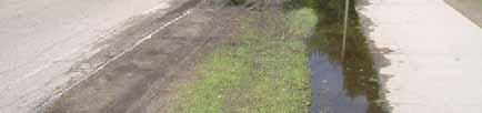
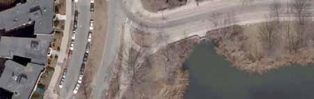
15 Agassiz Road Conceptual Design Figure 14 Locations of existing designated crosswalks (indicated with red circle) At the Queensberry Street intersection, there is a strong desire line in the landscape median between Park Drive and the service road (Figure 15). This suggests that most pedestrians coming to and from Queensberry Street area and Agassiz Road do not use the existing crosswalk, but rather follow the more direct line of travel and cross Park Drive in an undesignated area. At the Fenway intersection, there are several desire lines alongside Agassiz Road where the existing paved pathways and sidewalks do not follow the logical or desired flow of pedestrian Figure 15 Intersection of Queensberry Street and Park Drive, showing existing desire line crossing area (Bing Maps). travel. Crossing of Agassiz Road in the vicinity of the Duck House was observed by pedestrians following the diagonal stonedust path on the south side of the road. There are no existing, designated mid-block crosswalks on Agassiz Road. There are six drain inlets in Agassiz Road. According to Boston Water and Sewer Commission (BWSC) plans, most of these drain inlets seem to tie into a BWSC main drain located along the Fenway. Other drain inlets, remnants of the old, wider roadway in line with the old curbline, lie flush in the landscape area between the curbs and the pathways (Figure 11). For unknown reasons, these drain inlets were not capped but still have open drainage grates. Per the BWSC plans, most of these older drain inlets tie into the newer inlets. If the BWSC plans are accurate, then it can be assumed that the older drain inlets can be removed or abandoned if the roadway and pathway configurations are altered. All existing drain inlet grates are in a rectangular grid patterns and can be considered bicycle friendly. March

16 Agassiz Road Conceptual Design Existing street lighting consists of cobra head fixtures attached to concrete poles (Figure 16). These lights are on both sides of Agassiz Road, variably spaced and alternating, for a total of 10 poles along the street frontage. Most of the existing plants within or immediately adjacent to the DCR jurisdiction limits of Agassiz Road are large shade trees over lawn. With the exception of a lone basswood tree at the Park Drive intersection and a small red oak along the southern side of Agassiz Road, there are no other trees in the landscape areas between the road and sidewalk. Trees along the outside of the sidewalk include a mix of primarily pin oaks, red oaks, and basswoods. Other trees in the vicinity but outside of the project area include red and silver maples, ornamental crabapples, ashes, and weeping willows. At the Agassiz Road Bridge, there is a significant amount of unmaintained, mixed shrubby and invasive vegetation growing along the outside of the bridge wall and within the bridge planting shelves. Figure 16 Typical light pole and fixture along Agassiz Road. (May 25, 2011) 10 March 2012
17 Agassiz Road Conceptual Design Transportation Analysis As noted previously, Agassiz Road is an important corridor connecting the sections of the Fenway neighborhood to the west of Park Drive and east of Fenway, including the Symphony neighborhood. Owing to its location in relation to the surrounding area, it provides not only recreational access within the Emerald Necklace and the two abutting neighborhoods, but also as a pedestrian and bicycle route connecting a myriad of employment, educational, cultural, retail, recreational, and sports destinations in the Back Bay, Fenway, and Longwood neighborhoods. During late Fall 2009, a program of pedestrian, bicycle and vehicle counts were performed in the area by a team of volunteer residents and students from the Center for Community & Learning Partnerships at Wentworth Institute of Technology. As part of this project and to quantify pedestrian and bicycle activity under fairweather conditions along with updated vehicular counts, a new data collection program specific to Agassiz Road was executed in Spring The relevant data from 2009 and 2011 were combined and analyzed for pedestrians, bicycles and vehicles that are representative of good seasonal conditions for walking and cycling. For full transportation data and analysis, please see the Agassiz Road Site History and Existing Conditions Report. Below is a summary of the analysis. Because of its one-way eastbound direction, and its connection with one-way roadways at either end, Agassiz Road does not have a regional role in the roadway network. Rather, it is a local/district level roadway which primarily serves traffic departing the Fenway neighborhood and the Boylston Street area. Because all traffic enters Agassiz Road from the north and must exit to the north, it has limited attraction as a cut-through route for traffic, as reflected in the volumes of traffic using the road. There are no capacity issues at Park Drive, as there are no conflicting turning movements. At Fenway, traffic on Agassiz Road must stop and wait for a gap in the Fenway traffic flow. Capacity analysis indicates that there is no theoretical capacity issue for Agassiz Road traffic to exit onto Fenway. In practice, however, there is often a queue back from the nearby pedestrian signal and the signalized intersection on Fenway at the Westland Avenue resulting in some queuing on Agassiz Road while drivers wait for a gap to join the Fenway traffic flow. Occasionally, the stationary queue on Fenway presents an opportunity for Agassiz Road drivers to join Fenway at low speed through driver courtesy. In addition to the data collection, several pedestrian and bicycle use patterns were observed. As noted previously at the Queensberry Street intersection, a large proportion of pedestrians using Agassiz Road simply jay-walk to cross Park Drive, due to the inconvenient location of the existing crosswalks. At Fenway, although the signalized crosswalk at the carriage lane exit is located north of Agassiz Road, observations indicate that it is well-used. It does provide a safe crossing for pedestrians across the higher traffic flow, but a limited extent of jay-walking is observed at Agassiz Road because the crosswalk is some distance away. Although there are no specific bicycle accommodations, vehicular traffic is light and Agassiz Road provides an attractive alternative for cyclists to the heavily-trafficked Boylston Street and Huntington Avenue corridors to the north and south, respectively. The existing transportation system at Agassiz Road can be summarized as follows: Important pedestrian and bicycle corridor, but limited vehicular function Connects the neighborhood with multiple destinations Used by over 2,000 pedestrians and 270 bicyclists (average daily) on weekdays Used by over 1,500 pedestrians and 130 bicyclists on a Saturday Average daily traffic volumes are approximately 1,070 on weekdays and approximately 870 and 770 vehicles on Saturday and Sunday, respectively Highest traffic flow is 70 vehicles on a weekday evening peak hour Weekday travel patterns reflect commuter peak characteristics Bicyclists ride in both directions, on both the roadway and the sidewalk March
18 Agassiz Road Conceptual Design 12 March 2012

19 Agassiz Road Conceptual Design Conceptual Design Options Based on analysis of existing conditions and in consultation with DCR, several design criteria were established to guide the creation of the conceptual design options. In no particular order, these criteria are: Park land should be enhanced. Safety is a design priority. Traffic calming features should be incorporated in the design. New roadway cross-section should focus on pedestrian and bicycle accommodations. Pathways should allow for shared-use accommodations. Opportunities for new and enhanced crosswalks should be explored. Consideration should be given for the redesign of the Park Drive and Agassiz Road intersection in order to calm traffic. Un-met pedestrian desire line needs across Park Drive, between Agassiz Road and Queensbury Street, should be addressed. As revealed in the analysis of the existing transportation system, Agassiz Road carries a relatively low volume of motorized vehicles. It can be assumed that traffic capacity is not an issue, and thereby that additional roadway capacity is not necessary. But there is a relative high use of the corridor by pedestrians and bicyclists as one of the few routes across the Back Bay Fens section of the Muddy River. Thus the options for new roadway cross-sections should focus on improvements to the pedestrian and bicycle accommodations that are both safe and functional. Given the wide width of the one-way roadway and the propensity of a vehicle to speed as it merges off of Park Drive to Agassiz Road, consideration for traffic calming features should be incorporated in the designs. The existing crosswalks at the Park Drive and Fenway intersections well serve the outer pathways, but crosswalk accommodations for the inner, park pathways are not present. There is opportunity to provide a new crosswalk to connect the existing inner, stonedust pathways, bridging an obvious connection. Less obvious is the future use of the Duck House. Based on the final use and design of the Duck House and its immediate landscape, there may be the need to have a crossing in the mid-section of Agassiz Road. The Queensberry/Park Drive crosswalk is less than ideally suited for the more used direction of pedestrian travel. As in use in other parts of the Emerald Necklace, a 10-feet wide, bituminous concrete shared use path can provide accommodations for all non-vehicular users. With an understanding of the roadway s history and current use and conditions, three conceptual design options for the roadway and adjacent walks were prepared in cross-section. These options, along with considerations for new and enhanced crosswalks, were presented in a public meeting on October 3, Figure 17 Typical light pole and fixture along Agassiz Road. (June 2011). March
20 Agassiz Road Conceptual Design Option A Maintain Existing Roadway Width DuckHouseSide Figure 18 Option A cross section Maintain Existing Roadway Width Conceptual Design Option A maintains the existing roadways width of 18 to 19 feet. Line striping remains the same as currently exists with 1-foot wide shoulders on both sides (16 to 17-feet wide travel lane). To prevent parking alongside the road, new 9-inch high vertical granite curb lines both sides of the roadway. Per the historic design intent, the pathways are moved to be immediately adjacent to the curbline and are 10-feet wide to accommodate shared use. The existing cobra-head lights poles are replaced with pendant -style lights, now the DCR standard for parkways. The placement of the new light poles along the back edge of the pathways, rather than the edge of the roadway, allow for full illumination of both the pathways and roadway without restricting movement along the paths. As the roadway remains the same width, the existing drain inlets/catchbasins remain in place. Note that the functionality of the existing drain inlets is not known and further evaluation will be required to determine if these inlets are functional and successfully drain the roadway. The total roadway corridor is reduced down to 39 to 40 feet from the existing 50 feet (approximately) and puts at least 10 feet of non-paved land back into the park side of the corridor. This new park land is more easily maintained as grass and provides opportunities for new park tree, rather than street trees. 14 March 2012
21 Agassiz Road Conceptual Design Option B Reduced Roadway Width with Bike Lane DuckHouseSide Figure 19 Option B cross section Reduced Roadway Width with Bike Lane Conceptual Design Option B reduces the existing roadways width to 16 feet curb to curb. The reduced roadway is striped for a new 5-feet wide bicycle lane with an 11-feet vehicle travel lane. Like Option A, there are new 9- inch high vertical granite curb lining and 10-feet wide shared-use paths along both sides of the roadway. DCR pendant -style lights line the back edge of the path. As the roadway is reduced in width, the existing drain inlets/catchbasins will have to be relocated on at least one side of the roadway to the relocated curbline. The total corridor width is reduced to 37 feet, giving 13 feet of land back to the park side. Option C Reduced Roadway with Bike Lane and Landscape Strips DuckHouseSide Figure 20 Option C cross section Reduced Roadway Width with Bike Lane and Landscape Strips The roadway and bike lane configuration in Conceptual Design Option C matches the design shown in Option B including the use of 9-inch high granite curbs. But rather than having paths alongside the road, Option C incorporates landscape strips separating the paths from the roadway. With the limited width of the bridge, this means 9-feet wide landscape strips and 10 feet wide shared use paths on both sides. Unlike Options A and B, the landscape strips provide the opportunity to plant street trees and places new pendent light poles in amongst the row of trees. The result is more of a buffer to separate the pathways from the road. But, with the light pole placement, there is less light being cast on the pathways unless additional pedestrian scale fixtures are added. Like Option B, the drain inlets/catchbasins will have to be relocated along the new curbline(s). March


22 Agassiz Road Conceptual Design Crosswalks Concepts for several new and relocated crosswalks were presented at the October 3, 2011 meeting. Figure 21 shows locations for three proposed new crosswalks Figure 21 Diagram of existing crosswalks and conceptual locations for proposed new crosswalks 1. New crosswalk over Agassiz Road connecting the two inner stonedust paths on the Fenway side. Currently these paths are not served by a crosswalk and curb ramps although this is a significant pedestrian connection. 2. New crosswalk over Agassiz Road in the vicinity of the Duck House. The diagonal-running stonedust path on the south side of Agassiz Road creates the need for a mid-block crossing. 3. At Queensberry Street, the natural pedestrian flow for pedestrian coming and going from Agassiz Road and points south is to cross south of the intersection rather than use the less direct signalized crosswalk. Figures 22 and 23 show a conceptual scheme for the layout for a new or relocated Queensberry Street crosswalk that is more in line with the desired flow of pedestrian travel. Also note a conceptual sketch for reducing the curb radius from Park Drive onto Agassiz Road, with the intention of slowing vehicle speeds during the turning movement. Figure 22 Existing Conditions at Queensberry Street and Agassiz Road intersections Figure 23 Proposed conceptual plan for new crosswalks and curblines 16 March 2012

23 Agassiz Road Conceptual Design Preferred Conceptual Design Option Following the presentation of the conceptual design options, members of the public present discussed their issues and commented on the designs. At the conclusion of the meeting, the public was directed to vote on their preferred option. Figure 24 is a photograph of the voting board from that meeting, and, as evident, Option B was voted as the overwhelming favorite. Based public comments, they preferred to see bicycle lane striping and the placement of the pathways adjacent to the roadway. In the weeks following the public meeting, Pressley Associates and VHB met separately with DCR traffic engineers and the Boston Transportation Department to discuss and refine the design of Option B. After refinement of the design and taking into consideration comments from the public agencies, Option B was refined into a Preferred Conceptual Design (Figures 25 and 26). Figure 24 Photograph of conceptual design options voting board from October 3, 2011 meeting showing Option B as the option preferred by the public members in attendance March

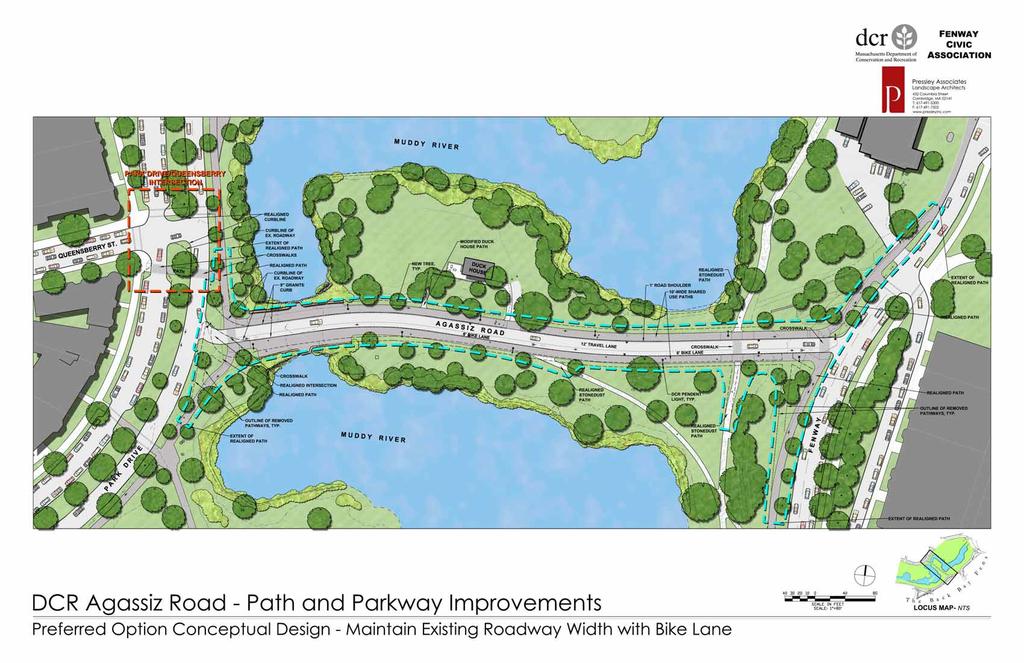
24 Agassiz Road Conceptual Design DuckHouseSide Figure 25 Preferred Conceptual Design Option cross section Figure 26 Preferred Conceptual Design Option plan (see appendices for scaled plan) Roadway Cross Section The Preferred Design Option keeps the roadway at consistently 19 feet width, similar to the existing width. By maintaining near the current width, no drain inlets will need to be relocated and saves on construction costs in this and other areas while allowing for a full bicycle lane and emergency vehicle access. As shown on the cross section in Figure 25, there is room to widen the bicycle lane to 6 feet width. This along with a one foot wide shoulder on the opposite side of the road reduces the active vehicular travel lane to 12 feet. Ten-feet wide shared use paths are adjacent to the roadway curbs. The cross-section for the preferred design option seeks to better allocate the curb-to-curb roadway width to accommodate bicycles in the one-way west-to-east direction of traffic flow, and also accomplish a trafficcalming influence on vehicle travel by reducing the travel lane width. The roadway must of course accommodate emergency vehicles, and, while a 16-foot roadway cross-section would likely be adequate in practice, it is anticipated that the Boston emergency service agencies will require an 18-foot minimum roadway width, particularly since the preferred option incorporates vertical granite curbs with a 9-inch reveals on both sides of Agassiz Road. The decision to maintain the wider width came about from discussions with the public agencies. The emergency vehicle requirement is compatible with maintaining the existing curbline width on Agassiz Road, thereby yielding a lower construction cost as no drainage structures will need to be relocated. Within this cross-section, there is some flexibility in how the roadway width is allocated by pavement striping. To reduce 18 March 2012

 or a striped buffer between the travel lane and the bicycle lane, therefore allowing for")
25 Agassiz Road Conceptual Design traffic speeds, the vehicle travel lane could be narrower than the traditional standard 12-foot lane. The 12-foot travel lane is shown in the Preferred Design Option cross section and plan, but in the final design, a 10-foot or 11-foot maximum width may be recommended to further calm traffic. The bicycle lane width should be a minimum of 5-foot, but there is room to easily increase the lane to at least 6-foot in the preferred design option. It is recommended that any available additional width should be allocated to edge striping (striped shoulder) or a striped buffer between the travel lane and the bicycle lane, therefore allowing for a minimumal width of the vehicle travel lane. Bicycle Lanes The Preferred Design Option cross-section and plan (Figures 25 and 26) show the bicycle lane in the conventional position on the right-hand side of Agassiz Road in the direction of travel, with the vehicle travel lane to its left. This configuration is where both vehicle drivers and bicyclists normally expect to be located relative to each other. The position of the bicycle lane, however, could be considered in the context of the existing connecting one-way roadway circulation, and the possibility of bicycle lanes being introduced on Park Drive and Fenway in the future. With Park Drive (southbound) connecting as a left-turn to Agassiz Road (eastbound), and in turn connecting to Fenway (northbound) as a left-turn, it would likely be easier and safer for bicyclists to maneuver if the bicycle lane on Agassiz Road was located on its left-hand side. While strictly this is not the conventional location for a bicycle lane, it is an acceptable, and possibly more desirable, location for a one-way roadway connecting other one-way roadways in this configuration. Left-side bicycle lanes have been implemented successfully on other one-way roadways in both Boston and Cambridge. As an example of this configuration, Option B prepared for the first public meeting showed that the bike lane on the left-hand side position (Figure 19). It is recommended that, ultimately, the final location of the bicycle lane should be determined closer to the time of construction, taking into consideration what, if any, bicycle accommodations have been planned or constructed for Park Drive and Fenway at that time. Roadway Intersections There is no proposed major redesign of the Agassiz Road/Fenway intersection, aside from some slight tightening of the radius curb with a better delineated striped crosswalk and curb cuts conforming to the new pathway layout and per current accessibility standards (Figure 28). A stop line should be clearly delineated before the crosswalk. Figure 27 Existing conditions at Fenway intersection (Bing Maps) Figure 28 Preferred Conceptual Design Option plan at Fenway intersection March

 Figure 30 Preferred Conceptual Design Option plan at Park Drive/Agassiz Road intersection Pathways and Crosswalks In")
26 Agassiz Road Conceptual Design In order to improve pedestrian and bicyclists safety at the Park Drive/Agassiz Road crosswalk and to better calm vehicular traffic, the Preferred Design Option proposes tightening the intersection by significantly reducing the curb radius. This should reduce the speed of vehicles coming off on Park Drive onto Agassiz Road. The design shown in Figure 30 is conceptual only and additional study and engineering design will be required to determine the best alignment and curb radius. Figure 29 Existing conditions at Park Drive/Agassiz Road intersection (Bing Maps) Figure 30 Preferred Conceptual Design Option plan at Park Drive/Agassiz Road intersection Pathways and Crosswalks In the Preferred Design Option, ten-feet wide shared use paths line both sides of Agassiz Road, immediately adjacent to the curb. These two shared-use paths connect to paths at both the Fenway and Park Drive intersection. DCR standard pendant lights, along the back edge of the shared use paths, illuminate both roadway and pathways. Along Fenway, the existing outer (DCR) paths are concrete, but there is opportunity to redesign the outer (DCR) Fenway paths to meet the standards of shared-use (ten-feet wide and bituminous concrete) as recognized in other parts of the Emerald Necklace. In the Preferred Conceptual Design, consideration is made to reconfigure the Fenway side pathways to better connect to the proposed shared use pathways on Agassiz Road. As shown in the existing aerial photo in Figure 27, the outer concrete pathway south of the intersection splits into two pathways as it approaches Agassiz Road from the south. The conceptual design (Figure 28) simplifies the arrangement into a single 10-feet wide path in the mode of the Agassiz Road shared use path design. The crosswalk at the end of Agassiz Road is realigned to be perpendicular to the flow of traffic with new fully accessible curb ramps. Consideration could also be given to a raised crosswalk treatment in this location to strengthen its traffic calming impact and improve the visibility of pedestrian and bicyclists crossing Agassiz Road A new striped designated crosswalk is proposed to connect the existing inner (BPRD) stonedust paths. A realignment of the pathways may be required to better align to the new crosswalk and shared use paths. A new crosswalk will also mean new accessible curb cuts, features that do not currently exist. At the Park Drive intersection with the proposed tightening of the intersection, the adjoining pathways are realigned to line up with a relocated crosswalk with curb cuts (see Figure 30). As with the intersection design, additional study and design will be needed to determine the best location for this crosswalk within the context of the tightened intersection. The final location of the Agassiz Road mid-block crosswalk will be dependent on the final use of the Duck House and the design of the landscape and pathways around the building. Therefore this crosswalk is not shown on the Preferred Design Option plan but is a feature recommended to be planned and designed as plans for the Duck House advances. Queensberry Street Intersection During the evaluation of existing conditions, it was determined that a substantial portion of pedestrians cross Park Drive to and from Agassiz Road on a diagonal desire line evidenced by compacted soil areas in the grass median and shoulders, south of Queensberry Street. Because of its location, the existing signalized crosswalk to the north of Queensberry Street is not commonly used by those pedestrians, although that crosswalk does 20 March 2012


27 Agassiz Road Conceptual Design provide an important and safe crossing for pedestrians between the neighborhoods and points north of Queensberry Street. It should be noted that the existing signalized crosswalk is part of the overall traffic signal control of the Park Drive/Queensberry Street intersection. Based on traffic volumes and observations in the field, however, it is unlikely that the traffic signal control satisfies traffic signal warrants. Therefore the signal is likely not needed from a traffic-control perspective, albeit that it does provide a protected pedestrian phase on the north side of the intersection. A stop sign at the end of Queensberry Street should suffice, but further evaluation of the existing and future Queensberry Street traffic signal warrants is necessary before final decisions are made. Figure 31 Existing conditions at Park Drive/Queensberry Street intersections (Bing Figure 32 Preferred Conceptual Design Option plan at Park Drive/Queensberry Street intersections It is clear that a crosswalk should be provided on Park Drive to the south of Queensberry in a location and configuration that is more compatible with the Agassiz Road desire-line. There are several potential ways to accomplish this, including: Incorporation of a new crosswalk within the intersection signalization; Elimination if the traffic signal with modifications to introduce un-signalized crosswalks and stop control at the intersection; Or, possibly, some hybrid design which retains the existing signal as a flashing-yellow warning indicator only. Additional crosswalk signage will be needed if the crosswalk is not protected with a red light traffic signal. Figure 32 shows a possible crosswalk configuration from a conceptual design point of view. The evaluation and identification for a safe and convenient pedestrian crossing configuration at this location is beyond the scope of this Agassiz Road study. Further detailed traffic evaluation and design is necessary, and therefore it is recommended that additional study of this facility should be performed closer to the time of anticipated construction. March
28 Agassiz Road Conceptual Design Order of Magnitude Cost Estimate For the purposes of determining both design and construction order of magnitude cost estimates, the concept described in the Preferred Conceptual Design has been divided into two discrete projects, Agassiz Road and the Queensberry Street Intersection. The scope of design work for both projects will require additional civil and traffic engineering, surveying, and landscape architectural design above and beyond the conceptual planning detailed in this report. Agassiz Road Estimated Construction Cost The estimated construction cost below is solely based on the Proposed Conceptual Design for Agassiz Road and associate pathways and landscape areas between Park Drive and Fenway. This estimate does not include the Queensberry Street intersection conceptual design. 1. Site Preparation and Demolition $40, Roadway Paving, Curbing, and Crosswalks $175, Pathway Paving $135, Lighting and Electrical $125, Fine Grading, Lawn, and Trees $25,000 TOTAL $500,000 Agassiz Road Estimated Design Cost The full design cost for the $500,000 construction project described above is estimated at approximately $75,000. This design cost estimate assumes there will be no City of Boston review since all roadways are within DCR jurisdiction. Since this project is within DCR jurisdiction, three design submissions can be expected. The design cost estimate includes the following: Field Survey and updated Existing Conditions Plan Preliminary Design Environmental Permitting DCR Permits and Meetings Project Meetings Final Design Bid Phase Services Note: The Agassiz Road area of the Back Bay Fens falls within the construction zone for Phase 2 of the Muddy River Restoration Project. This report recommends that any improvements to Agassiz Road should be coordinated with the U.S. Army Corps of Engineers and the implementation of the Phase 2 Muddy River Restoration Project. 22 March 2012
29 Agassiz Road Conceptual Design Queensberry Street Intersection Estimated Construction Cost The estimated construction cost below is solely based on the Proposed Conceptual Design. As this part of the proposed plan is subject to additional study, planning, and design above and beyond the additional design for just Agassiz Road, the cost shown below should be seen as a minimum construction cost and will most likely be higher if signalization significantly changes. Final, actual construction costs for each construction component described below may differ based on final design decisions for roadway configuration, crosswalk design and location, and changes to traffic signalization and signage. 1. Site Preparation and Demolition $5, Roadway Paving, Curbing, and Crosswalks $10, Pathway Paving $5, Lighting and Electrical $25, Allowance for Signalization Changes $12, Fine Grading and Lawn $2,00 TOTAL $60,000 Queensberry Street Intersection Estimated Design Cost Due to the fact that further preliminary study is necessary for the Queensberry Street intersection and crosswalks, $30,000 is estimated for preliminary traffic and civil engineering. Preliminary engineering includes the following: Planning Study and Technical Memo Field Survey and updated Existing Conditions Plan (can be incorporated into Agassiz Road Field Survey described above, thereby reducing costs) 3 to 4 concept plans for intersection and crosswalk design Project Meetings (DCR, public, etc) For Final Design, the design cost will depend on the selected concept design and the level of engineering design involved (curb line shifts, drainage modifications, changes in signalization, etc). Since this project is within DCR jurisdiction, three design submissions can be expected. Final design cost can range from $20,000 - $45,000 over and above the $30,000 needed for preliminary traffic engineering. March
30 Agassiz Road Conceptual Design 24 March 2012
31 Agassiz Road Conceptual Design Appendices 1. Existing Conditions Plan (60 scale) 11 x17 2. Preferred Conceptual Design Option Plan (80 scale) 11 x17 3. Public Meeting Presentations March
32 Agassiz Road Conceptual Design 26 March 2012
33
34
35 October 3, 2011 EmeraldNecklace AgassizRoadConceptualDesign ADCRandFenwayCivicAssociationPartnershipProject DCR Public Meeting October 3, 2011, 6:30 pm 8:00 pm Berklee College of Music 142 Massachusetts Ave., 2 nd Floor Boston, MA 1 Agassiz Road Conceptual Design Project Team DCR Fenway Civic Association Pressley Associates VHB 1


36 October 3, 2011 Project Location Project Objectives Enhance facilities for multiple modes of use Maximize safety and minimize conflicts for all users Integrate parkway into parkland Improve neighborhood connections Improve landscape aesthetics Incorporate pathway and crosswalk treatment guidelines 2
37 October 3, 2011 Scope of Work Existing Conditions Inventory and Assessment o Historic research o Landscape conditions o Pedestrian, bicycle, and traffic counts o Site History and Existing Conditions Report Conceptual Plan Alternatives o Roadway and pathway design o Landscape treatments o Crosswalk improvements o First Public Meeting Preferred Conceptual Design o Second Public Meeting o Final Conceptual Design Report Pathway and Crosswalk Treatment Guidelines Boylston Street at the Back Bay Fens to the Casey Overpass at the Arborway Map showing extent of DCR Emerald Necklace Pathway and Crosswalk Treatment Guidelines (Base Map courtesy of Emerald Necklace Conservancy) 3
38 October 3, 2011 DCR Jurisdictional Limits Muddy River Duck House Agassiz Road Muddy River Agassiz Road Historic Design 4
39 October 3, 2011 Historic Plans 1887 Plan of the Back Bay Fens Historic Plans 1921 Survey of the Back Bay Fens 5
 Historic Roadway Profile 35 Roadway (2) 10 Pathways 55 Total Profile Duck House")
40 October 3, 2011 Circa 1900 s Intersection of Agassiz Road and Audubon Road (Park Drive) Historic Roadway Profile 35 Roadway (2) 10 Pathways 55 Total Profile Duck House Side 6


41 October 3, 2011 Conversion to One-Way Traffic Existing Curbline Historic Curbline Agassiz Road Existing Site Conditions 7


42 October 3, 2011 Existing Site Conditions Bing Maps Existing Site Conditions 8
43 October 3, 2011 Existing Roadway Profile Roadway Sloped Curbs 9-10 Landscape Strips (2) 6 Pathways 50 Roadway Profile Cobrahead light poles Duck House Side Existing Roadway Profile at Bridge 19 Roadway Sloped Curbs Landscape Strips (2) 6 Pathways 55 Roadway Profile No lights on bridge 9


44 October 3, 2011 Existing Site Conditions Agassiz Road Transportation Analysis 10


45 October 3, 2011 Transportation Context Existing Roadway Layout 11
 450 400 350 300 250 200 150 100 50 0 Saturday 253 124 132 92 58 82 52 58 60 54 27 12 31 42 69 80 63 86 90 112 111 61 11 54 Westbound Eastbound")

46 October 3, 2011 Agassiz Road Pedestrian Volumes Number of Pedestrians (per hour) Friday Number of Pedestrians (per Hour) Saturday Westbound Eastbound 12HourTotals EB1,085 WB1,400 Total2,485 Hour Commencing 12HourTotals EB811 WB1,003 Total1,814 Hour Commencing Note: Based on counts preformed on May 6 & 7, Hr Pedestrian Counts Directional Distribution 64% 65% 60% 76% 69% 63% 49% 49% 69% 78% 36% 35% 51% 51% 31% 37% 31% 22% 40% 24% Red Weekday % Green Weekend % Note: Based on Friday and Sunday counts performed in November
47 October 3, 2011 Agassiz Road Bicycle Volumes Number of Bicycles (per Hour) Friday Number of Bicycles (per Hour) Saturday Westbound Eastbound Hour Commencing Hour Commencing 12HourTotals EB111 WB155 Total266 12HourTotals EB64 WB65 Total129 Note: Based on counts preformed on May 6 & 7, 2011 Agassiz Road Daily Traffic Volumes 1,200 1,141 1,000 1,045 1,080 1,073 1, Vehicles per Day (VPD) Wednesday Thursday Friday Saturday Sunday Monday Tuesday Day of Week (June 23, June 29, 2011) 13
48 October 3, Agassiz Road Friday & Saturday Hourly Traffic Volumes Saturday Friday Vehicles per Hour (VPH) Hour Commencing Note: Based on counts preformed on June 25 & 26, 2011 Vehicle Weekday Commuter Peak Hour Traffic Counts AM Peak Hour PM Peak Hour Note: Based on counts performed in November 2009 and June
49 October 3, 2011 Agassiz Road Design Options Design Considerations Enhancement of Park Land Roadway and Path Width Accommodations for Shared-Use New and Enhanced Crosswalks Park Drive and Fenway Intersections 15


50 October 3, 2011 Shared-Use Path Example Olmsted Park Brookline Side Shared-Use Path Example Olmsted Park Boston Side 16
51 October 3, 2011 Option A Maintain Existing Roadway Width Roadway (maintains existing road width) (2) 10 Shared-Use Pathways adjacent to roadway (historic precedence) 39 Total Profile with 9 -high vertical curbs DCR Pendant-style light poles Least expensive option (no change in curb alignment) Duck House Side Option B Reduced Roadway Width 16 Roadway (reduced roadway width) 11 Auto Lane; 5 Bicycle Lane shown (2) 10 Shared-Use Pathways adjacent to roadway (historic precedence) 37 Total Profile with 9 -high vertical curbs DCR Pendant-style light poles Expense involved in re-aligning curbline Duck House Side 17
52 October 3, 2011 Option C Reduced Roadway with Landscape Strips 16 Roadway (reduced roadway width) 11 Auto Lane; 5 Bicycle Lane shown (2) 10 Shared-Use Pathways separated from roadway 9 Landscape Strips (Trees optional) 55 Total Profile with 9 -high vertical curbs DCR Pendant-style light poles Expense involved in re-aligning curbline Duck House Side Existing Crosswalk Locations Duck House Agassiz Road Existing Crosswalk (designated) 18
 Proposed New Crosswalk (designated)")

53 October 3, 2011 Proposed Crosswalk Locations Duck House Existing Crosswalk (designated) Proposed New Crosswalk (designated) Proposed Crosswalk Locations Duck House Duck House Agassiz Road Existing Crosswalk (designated) Proposed New Crosswalk (designated) 19

 Proposed New")

54 October 3, 2011 Proposed Crosswalk Locations Fenway Existing Crosswalk (designated) Proposed New Crosswalk (designated) Proposed Crosswalk Locations Park Street Existing Crosswalk (designated) Proposed New Crosswalk (designated) 20
55 October 3, 2011 Proposed Crosswalk Locations Park Street Existing Crosswalk (designated) Proposed New/Relocated Crosswalk (designated) Next Steps Decision on Preferred Conceptual Design Option Refine Conceptual Design Mid November Meeting to Present Preferred Conceptual Design Option Final Report 21

56 November 21, 2011 EmeraldNecklace AgassizRoadConceptualDesign ADCRandFenwayCivicAssociationPartnershipProject DCR Public Meeting November 21, 2011, 6:30 pm 8:00 pm Wheelock College Campus Multi-Purpose Room 1st Floor, Room The Riverway 1 Agassiz Road Conceptual Design Project Team DCR Fenway Civic Association Pressley Associates VHB 1
57 November 21, 2011 Project Location Project Objectives Enhance facilities for multiple modes of use Maximize safety and minimize conflicts for all users Integrate parkway into parkland Improve neighborhood connections Improve landscape aesthetics Incorporate pathway and crosswalk treatment guidelines 2
58 November 21, 2011 Scope of Work Existing Conditions Inventory and Assessment o Historic research o Landscape conditions o Pedestrian, bicycle, and traffic counts o Site History and Existing Conditions Report Conceptual Plan Alternatives o Roadway and pathway design o Landscape treatments o Crosswalk improvements o First Public Meeting Preferred Conceptual Design o Second Public Meeting o Final Conceptual Design Report DCR Jurisdictional Limits Muddy River Duck House Agassiz Road Muddy River 3
59 November 21, 2011 Circa 1900 s Intersection of Agassiz Road and Audubon Road (now Park Drive) looking east Existing Roadway Layout Existing Crosswalks indicated in green Existing Paths indicated in brown 4
60 November 21, 2011 Existing Roadway Profile Roadway Low, Sloped Curbs (2) 9-10 Landscape Strips (2) 6 Pathways 50 Total Roadway Profile (approx.) Cobrahead light poles Duck House Side Transportation Analysis Existing Conditions Important pedestrian and bicycle corridor, but limited vehicular function Connects the neighborhood with multiple destinations Park Drive Used by over 2,000 pedestrians and 270 bicyclists on weekdays Agassiz Road Duck House Used by over 1,500 pedestrians and 130 bicyclists on a Saturday Highest traffic flow is 70 vehicles on a weekday evening peak hour Fenway Weekday travel patterns reflect commuter peak characteristics Bicyclists ride in both directions, on both the roadway and the sidewalks 5
61 November 21, 2011 Transportation Analysis Design Needs New roadway cross-section should focus on pedestrian and bicycle accommodations Safety is a design priority Traffic capacity is not an issue Traffic calming features should be incorporated in the design Opportunity for new pedestrian crossing near Duck House Crosswalk improvements on Park Drive call for carefully designed accommodations including a new crosswalk Duck House Design Considerations A Enhancement of Park Land Roadway and Path Width Accommodations for Shared-Use B New and Enhanced Crosswalks Park Drive and Fenway Intersections C 6
62 November 21, 2011 Voting from October 3 rd Meeting A B C Option B 16 Roadway (reduced roadway width) 11 Auto Lane; 5 Bicycle Lane shown (2) 10 Shared-Use Pathways adjacent to roadway (historic precedence) 37 Total Profile with 9 -high vertical curbs DCR Pendant-style light poles Expense involved in re-aligning curb line (new drain inlets) Duck House Side Note that overall dimension of 37 includes 6 curbs on both sides of roadway 7
63 November 21, 2011 Proposed Crosswalk Locations Duck House Existing Crosswalk (designated) Proposed New Crosswalk (designated) Conceptual Design Preferred Option 19 Roadway (maintains existing roadway width) 12 Auto Lane plus 1 striped shoulder; 6 delineated Bicycle Lane 9 -high Vertical Granite Curbs (2) 10 Shared-Use Pathways adjacent to roadway (paved with bit. concrete) 40 Total Roadway Profile width (10 back into park land) DCR Pendant-style light poles Maintain existing Drain Inlets Duck House Side 8


64 November 21, 2011 Conceptual Design Duck House Side Section Note that overall dimension of 40 includes 6 curbs on both sides of roadway Plan Preferred Option Conceptual Design Existing Condition 9


65 November 21, 2011 Preferred Option Conceptual Design Conceptual Plan Agassiz Road Existing Condition 10


66 November 21, 2011 NEW CROSSWALK REMOVED PATHWAY Conceptual Plan Existing Condition 11


67 November 21, 2011 TIGHTENED CURBLINES NEW CROSSWALKS TIGHTENED INTERSECTION REALIGNED PATHWAY REMOVED PATHWAY Proposed Plan Next Steps Final Report posted to DCR Website Mid-December Design and Construction Subject to available funding and in coordination with Army Corps Muddy River project 12
Active Transportation Facility Glossary
 Active Transportation Facility Glossary This document defines different active transportation facilities and suggests appropriate corridor types. Click on a facility type to jump to its definition. Bike
Broad Street Bicycle Boulevard Design Guidelines
 Broad Street Bicycle Boulevard Design Guidelines Building from the strategies introduced in the 2013 Bicycle Transportation Plan and community input received thus far, City Transportation Staff have identified
Charlesgate. World Series Path
 Tonight s 8 Greenway Designs Commonwealth Ave. Route 9 Crossing Charlesgate Dartmouth St. World Series Path Summer St / L St Arborway 2008 Charlesgate Connection Northeastern University s Civil Engineering
CURBSIDE ACTIVITY DESIGN
 5 CURBSIDE ACTIVITY DESIGN This chapter provides design guidance for separated bike lanes adjacent to curbside activities including parking, loading and bus stops. Typical configurations are presented
Summary: Mercer County Princeton Avenue & Spruce Street Study January 2009
 Summary: Several recent studies have assessed potential development and redevelopment opportunities in the Mercer Crossing area of Trenton, Ewing, and Lawrence. This Princeton Avenue and Spruce Street
Chapter 2: Standards for Access, Non-Motorized, and Transit
 Standards for Access, Non-Motorized, and Transit Chapter 2: Standards for Access, Non-Motorized, and Transit The Washtenaw County Access Management Plan was developed based on the analysis of existing
5 Circulation & Parking
 5 Circulation & Parking Downtown Parking & Circulation Strategy. Downtown Wayne has a somewhat disconnected system of local public streets to connect downtown with the residential neighborhoods, and primary
Boston Post Road Design Feasibility Study
 Boston Post Road Design Feasibility Study Prepared for the City of Rye Final Report July 18, 2007 Prepared by: Buckhurst Fish & Jacquemart (BFJ) 115 Fifth Avenue New York, NY 10003 www.bfjplanning.com
Vision: Traditional hamlet with an attractive business/pedestrian friendly main street connected to adjacent walkable neighborhoods
 N D. Focus Area II Vision: Traditional hamlet with an attractive business/pedestrian friendly main street connected to adjacent walkable neighborhoods Transit Road Focus Area II is located in the Hamlet
Draft North Industrial Area-Wide Traffic Plan
 Summary of North Industrial and Hudson Bay Industrial Recommended Improvements Table 1. Summary of s Item Location 1 2 3 4 5 6 7 8 9 10 11 12 Millar Ave north of 51st St Super 8 Motel back lane 400 Block
Giles Run Connector Road
 Giles Run Connector Road Laurel Hill Adaptive Reuse Area to Laurel Crest Drive South County Federation Meeting June 14, 2016 History Connector road included in the Laurel Hill Comprehensive Plan amendment
FOCUS AREA 1 - Alberta Avenue Pocket Park 3 (121 Ave and 92 St)
") FOCUS AREA 1 - Alberta Avenue Pocket Park 3 (121 Ave and 92 St) New benches Plant evergreen trees Widen existing sidewalk from 1.5m to 1.8m Marked crosswalk 1.8m wide sidewalk Add pedestrian oriented lights
FOCUS AREA 1 - Alberta Avenue Pocket Park 3 (121 Ave and 92 St) New benches Plant evergreen trees Widen existing sidewalk from 1.5m to 1.8m Marked crosswalk 1.8m wide sidewalk Add pedestrian oriented lights
APPENDIX A: Complete Streets Checklist DRAFT NOVEMBER 2016
 APPENDIX A: Complete Streets Checklist DRAFT NOVEMBER 2016 Complete Streets Checklist MetroPlan Orlando s Complete Streets Checklist is an internal planning tool for staff to further implementation of
Appendix C. TRAFFIC CALMING PROGRAM TOOLBOX
 Appendix C. TRAFFIC CALMING PROGRAM TOOLBOX PHASE I...2 Do Not Enter Sign...3 One-Way Sign...4 Turn Prohibition...5 Pavement Markings...6 Speed Monitoring Trailer...7 Neighborhood Speed Watch...8 Police
Tonight is for you. Learn everything you can. Share all your ideas.
 Strathcona Neighbourhood Renewal Draft Concept Design Tonight is for you. Learn everything you can. Share all your ideas. What is Neighbourhood Renewal? Creating a design with you for your neighbourhood.
TRAFFIC CALMING GUIDE FOR TORONTO CITY OF TORONTO TRANSPORTATION SERVICES DIVISION
 TRAFFIC CALMING GUIDE FOR TORONTO CITY OF TORONTO TRANSPORTATION SERVICES DIVISION CITY OF TORONTO TRANSPORTATION SERVICES DIVISION 2016 TRAFFIC CALMING GUIDE FOR TORONTO TABLE OF CONTENTS Introduction
Blair/Williamson Intersection Expressed Needs
 Blair/Williamson Intersection Expressed Needs NORTH Blair Street is a barrier for pedestrians and bicycles Relocate Capitol City Trail crossing from Blair Street and John Nolen Drive intersection to Williamson
Los Altos Hills Town Council - June 18, 2015 Palo Alto City Council June 22, AGENDA ITEM #2.B Presentation
 Los Altos Hills Town Council - June 18, 2015 Palo Alto City Council June 22, 2015 AGENDA ITEM #2.B Presentation Previous Presentations Los Altos Hills Town Council in May 2014 and February 2015 Palo Alto
M-58 HIGHWAY ACCESS MANAGEMENT STUDY Mullen Road to Bel-Ray Boulevard. Prepared for CITY OF BELTON. May 2016
 M-58 HIGHWAY ACCESS MANAGEMENT STUDY Prepared for CITY OF BELTON By May 2016 Introduction Missouri State Highway 58 (M-58 Highway) is a major commercial corridor in the City of Belton. As development has
July 13, Commissioner Richard Sullivan Department of Conservation and Recreation 251 Causeway Street Boston, MA RE: EOEA ENF 13777
 July 13, 2007 Commissioner Richard Sullivan Department of Conservation and Recreation 251 Causeway Street Boston, MA 02110-1301 RE: EOEA ENF 13777 Dear Commissioner Sullivan: WalkBoston has been a steady
MAG Town of Cave Creek Bike Study Task 6 Executive Summary and Regional Significance Report
 Page 1 MAG Town of Cave Creek Bike Study Task 6 Executive Summary and Regional Significance Report August 1, 2012 MAG Project #481 Page 2 Task 6 Executive Summary and Regional Significance Report Introduction
Off-road Trails. Guidance
 Off-road Trails Off-road trails are shared use paths located on an independent alignment that provide two-way travel for people walking, bicycling, and other non-motorized users. Trails specifically along
2014/2015 BIKE ROUTE PLAN 83 AVENUE PROTECTED BIKE LANE
 About the Project The City of Edmonton is planning a major bike route on the southside of Edmonton. The Strathcona Bike Route will connect the communities of Strathcona, Garneau and the University area,
Complete Streets. Designing Streets for Everyone. Sarnia
 Complete Streets Designing Streets for Everyone Sarnia Complete Streets ~ Sarnia ~ 2018 Introduction Our City is made up of a network of streets that we use to go for a walk, cycle to work, drive to the
TRANSPORTATION COMMISSION Agenda Staff Report
 TRANSPORTATION COMMISSION Agenda Staff Report Agenda Item No. 5.a DATE: JULY 31, 2014 TO: FROM: SUBJECT: TRANSPORTATION COMMISSION COMMUNITY DEVELOPMENT DEPARTMENT - PLANNING DRAFT OLYMPIC CORRIDOR PREFERRED
NJDOT Complete Streets Checklist
 Background The New Jersey Department of Transportation s Complete Streets Policy promotes a comprehensive, integrated, connected multi-modal network by providing connections to bicycling and walking trip
TRANSPORTATION STANDARDS
 INTRODUCTION LOCAL STREETS ON-STREET PARKING SIDEWALKS STREET LIGHTING STREET FURNISHINGS TRAFFIC CALMING STREET TREES MEDIAN PLANTING BOULEVARD LOCATIONS VILLAGE CENTER STREET LOCATIONS RESIDENTIAL STREET
Watertown Complete Streets Prioritization Plan. Public Meeting #1 December 14, 2017
 Watertown Complete Streets Prioritization Plan Public Meeting #1 December 14, 2017 Goals for Public Meeting Overview of MassDOT Complete Streets Funding Program Educate the community on Complete Streets
2014/2015 BIKE ROUTE PLAN 83 AVENUE PROTECTED BIKE LANE
 About the Project 2014/2015 BIKE ROUTE PLAN The City of Edmonton is planning a major bike route on the south side of Edmonton. This bike route is one part of a plan to provide citizens with transportation
CONNECTIVITY PLAN. Adopted December 5, 2017 City of Virginia Beach
 CONNECTIVITY PLAN Adopted December 5, 2017 City of Virginia Beach CONTENTS 1.0 Background & Purpose... 2 2.0 Existing Inventory & Analysis... 3 ViBe District Existing Walking Conditions... 4 3.0 ViBe District
Memorandum. Sunday, July 13, Saturday, July 19, 2014
 Memorandum To: David Lowin, Brooklyn Bridge Park Corporation From: Daniel Schack, AICP, PTP Date: Re: Brooklyn Bridge Park Pier 5/6 Loop Road Traffic Study Project No: 14-01-2407 At the request of Brooklyn
Cycle Track Design Best Practices Cycle Track Sections
 Design Best Practices Sections It is along street segments where the separation and protection methods of cycle tracks offer more comfort than conventional bicycle lanes, and are more attractive to a wide
What Is a Complete Street?
 Session 5 Charleen Zimmer, AICP, Zan Associates May 5-7, 2010 What Is a Complete Street? May 2010 5-1 Not a Complete Street More of a Complete Street May 2010 5-2 Benefits of Complete Streets Safety for
CITY OF WEST LAKE HILLS. Forest View Neighborhood Traffic Calming Study
 CITY OF WEST LAKE HILLS 901 South Mopac Expressway Building V, Suite 220 Austin, Texas 78746 Texas P.E. Firm Registration No. F-929 Klotz Associates Final Report Submittal: March 20, 2015 Revised Final
COWETA HIGH SCHOOL AND EAST HIGHWAY 51
 COWETA HIGH SCHOOL AND EAST HIGHWAY 51 Lack of sidewalks along Ben Lumpkin Rd. Lack of crosswalks and ramps at intersection. Hwy 51 is wide to cross as a pedestrian. No ADA compliance or connection to
Orange Center Elementary School
 Drag and drop pic and stretch/crop to the limits of the blue rectangle (delete this text box) Orange Center Elementary School Drag and drop pic and stretch/crop to the limits of the blue rectangle (delete
Board of Supervisors February 27, 2017
 : Traffic Analysis Results & Draft Conceptual Plan Board of Supervisors February 27, 2017 Transportation Solutions Building Better Communities Presentation Overview Background Summary of Traffic Analysis
DUNBOW ROAD FUNCTIONAL PLANNING
 DUNBOW ROAD FUNCTIONAL PLANNING Final Report August 3, 216 #31, 316 5th Avenue NE Calgary, AB T2A 6K4 Phone: 43.273.91 Fax: 43.273.344 wattconsultinggroup.com Dunbow Road Functional Planning Final Report
Newport City Thoroughfare Plan
 Newport City Thoroughfare Plan Summary This plan is intended to review and make recommendations for Newport City s thoroughfare network, in consideration of the full range of uses of the city s streets.
SECTION 1 - TRAFFIC PLANNING
 SECTION 1 - TRAFFIC PLANNING 1.1 TRAFFIC OPERATIONS 1.1.1 Roadway Functional Classification The Multnomah County Comprehensive Framework Plan s Policy 34: Trafficways and the Functional Classification
Appendix 3 Roadway and Bike/Ped Design Standards
 Appendix 3 Roadway and Bike/Ped Design Standards OTO Transportation Plan 2040 4/20/2017 Page A3-1 Adopted Standards The adopted OTO Design Standards and Major Thoroughfare Plan are contained herein.
Figure 4-10: Pedestrian Improvements Types of Potential Station Area Improvements - Place-Making Improvements
 INCORPORATE FEATURE PAVIN IN CROSSWALK AND INTERSECTION FIELDS Identifies high-priority pedestrian areas and create a station identity through colorful and interesting patterns ADD CURB EXTENSIONS Extending
Fulton Market Streetscape
 Fulton Market Streetscape Ogden Avenue to Halsted Street Public Meeting Recommended Improvements December 10th, 2014 Meeting Purpose and Goals Present Existing Conditions Community Input and Charrette
Bridges and Arizona Crossings
 Circulation and Transportation 5-11 Discovery Street/Barham Drive. Discovery Street is planned 5.4.3 Specific Plan Circulation Improvements to be extended eastward from its terminus at Craven Road Circulation
Princeton Avenue and Spruce Street Transportation and Site Access Enhancements Project
 Princeton Avenue and Spruce Street Transportation and Site Access Enhancements Project Mercer County Planning Division AECOM Transportation (formerly DMJM Harris) January 29, 2009 Agenda Project Status
Traffic Circulation & Pedestrian Safety Study
 Lyons Township High School North Campus La Grange, Illinois Parking Lot Vaughan Building N Main Building Prepared for: Prepared by: July 23, 2015 Contents List of Figures, iii 1. Introduction...1 2. Existing
EUCLID AVENUE PARKING STUDY CITY OF SYRACUSE, ONONDAGA COUNTY, NEW YORK
 EUCLID AVENUE PARKING STUDY CITY OF SYRACUSE, ONONDAGA COUNTY, NEW YORK CITY OF SYRACUSE DEPARTMENT OF PUBLIC WORKS 1200 CANAL STREET EXTENSION SYRACUSE, NEW YORK 13210 DRAFT REPORT DATE: November 13,
Glebe Neighbourhood Cycling Plan
 Glebe Neighbourhood Cycling Plan Summary of Public Comments received after June 5 th Public Information Session Comment STUDY NETWORK CS9, CS8, E, E0 CS4, E CS4 CS8 E Suggestions for alternate cycling
Physical Implications of Complete Streets Policies
 Presentation Overview Physical Implications of Complete Norm Cox, ASLA, LLA Landscape Architect Ann Arbor, Michigan, 10:45 to Noon What Are Complete Streets? What Matters to Bicyclists and Pedestrians
10.0 CURB EXTENSIONS GUIDELINE
 10.0 CURB EXTENSIONS GUIDELINE Road Engineering Design Guidelines Version 1.0 March 2017 City of Toronto, Transportation Services City of Toronto Page 0 Background In early 2014, Transportation Services
El Camino Real Specific Plan. TAC/CAC Meeting #2 Aug 1, 2018
 El Camino Real Specific Plan TAC/CAC Meeting #2 Aug 1, 2018 Land Use Alternatives Goals and Tradeoffs Parks & open space Housing Retail & services Civic spaces Parking Community gathering spaces 3 Alternatives
Transportation Corridor Studies: Summary of Recommendations
 Transportation Corridor Studies: Summary of Recommendations Route 4 Corridor Study: Route 10 Corridor Study: Route 44 Corridor Study: Route 175 Corridor Study: Route 5/15 Corridor Study: Rentschler Field
1 st and 2 nd Street Couplet FAQ s
 1 st and 2 nd Street Couplet FAQ s Q. Will the proposed roundabout at Flume/2nd/1 st Streets affect access to businesses nearby?... 2 Q. What if the project isn t received well by the community after construction?...
Recommended Roadway Plan Section 2 - Land Development and Roadway Access
 Recommended Roadway Plan Section 2 - Land Development and Roadway Access SECTION 2 Land Development and Roadway Access 2.1 Land Use and Access Management The Federal Highway Administration (FHWA) defines
section 4 Existing Conditions, Issues, and Options
 section 4 Existing Conditions, Issues, and Options 4.0 Existing Conditions, Issues, and Options This section analyzes each segment of the corridor on a street to street basis. Each segment is discussed
Appendix T CCMP TRAIL TRAFFIC & TRANSPORTATION DESIGN STANDARD
 Appendix T CCMP 3.3.4 TRAIL TRAFFIC & TRANSPORTATION DESIGN STANDARD 3.3.4 Trail Traffic and Transportation Design Multi-use trails have certain design standards, which vary depending on the agency that
Multi-Modal Traffic Analysis. Parisi and Associates
 Mill Valley to Corte Madera Bicycle and Pedestrian Corridor Study Appendix D: Multi-Modal Traffic Analysis Prepared by Parisi and Associates August 2009 Appendix D - Multi-Modal Traffic Analysis Table
Landmark Center Rotary Path and Roadway Redesign Team Members:
 Path and Roadway Redesign Executive Summary Team Members: PM: Will Miller Jeff Haelle Nick Gaboury John Tamburrini Jon Simmons Table of Contents Page 1 Locus Map... 2 Introduction... 3 Current Problems
Chapter 3: Multi-Modal Circulation and Streetscapes
 CHAPTER 3: MULTI-MODAL CIRCULATION AND STREETSCAPES Chapter 3: Multi-Modal Circulation and Streetscapes Overview Streetscape improvements have already been completed for Depot Street between Main Avenue
City of Albert Lea Policy and Procedure Manual 4.10 ALBERT LEA CROSSWALK POLICY
 4.10 ALBERT LEA CROSSWALK POLICY PURPOSE: Pedestrian crosswalks are an integral part of our transportation infrastructure. To be effective and promote safety, marked crosswalks must be installed after
Bikeway action plan. Bicycle Friendly Community Workshop March 5, 2007 Rochester, MN
 Bikeway action plan Summary The was held on March 5, 2007 at the Rochester Mayo Civic Center. The workshop was hosted by Rochester-Olmsted County Planning Department in collaboration with the League of
Item to be Addressed Checklist Consideration YES NO N/A Required Description Complete Streets Guidelines
 Passaic County Complete Streets Checklist - Concept Development Project Name Item to be Addressed Checklist Consideration YES NO N/A Required Description Complete Streets Guidelines Existing Plans Have
2.0 Existing Conditions
 20 2.0 Existing Conditions 2.1 Land Use, Future Growth Patterns, Physical Barriers Geographic Overview Sutter County s land use pattern is characterized by extensive agricultural areas, significant natural
Transportation Planning Division
 Transportation Planning Division Presentation Outline Study Tasks Recap of Previous Meetings Data Collected Focus Areas within Study Limits Design Principles Tool Box Recommended Concepts Schedule Moving
Lake Whitney Elementary School
 Lake Whitney Elementary School SCHOOL ROUTE PLAN For LAKE WHITNEY ELEMENTARY SCHOOL LOCATION 18 ORANGE COUNTY Prepared for: ORANGE COUNTY SCHOOL ASSESSMENT PROGRAM ORANGE COUNTY PUBLIC WORKS Traffic Engineering
2.0 LANE WIDTHS GUIDELINE
 2.0 LANE WIDTHS GUIDELINE Road Engineering Design Guidelines Version 2.0.1 May 2018 City of Toronto, Transportation Services City of Toronto Page 0 Background In early 2014, Transportation Services initiated
Date: April 4, Project #: Re: A Street/Binford Street Traffic/Intersection Assessment
 To: Peter Cavanaugh General Electric From: David Bohn, PE Ryan White, PE Date: April 4, 217 Project #: 13421. Re: / Traffic/Intersection Assessment Consistent with the Cooperation Agreement between the
Dr. M.L. King, Jr. Street North Complete Streets Resurfacing Opportunities HOUSING, LAND USE, AND TRANSPORTATION COMMITTEE MARCH 22, 2018
 Dr. M.L. King, Jr. Street North Complete Streets Resurfacing Opportunities HOUSING, LAND USE, AND TRANSPORTATION COMMITTEE MARCH 22, 2018 What s Happening The City plans to mill and resurface Dr. M.L.
DEPARTMENT OF ENVIRONMENTAL SERVICES. North Harrison Street (Lee Highway to Little Falls Road) Comparative Analysis. Prepared for:
 Comparative Analysis. Prepared for:") DEPARTMENT OF ENVIRONMENTAL SERVICES North Harrison Street (Lee Highway to Little Falls Road) Comparative Analysis Prepared for: Arlington County Department of Environmental Services 2100 Clarendon Boulevard,
DEPARTMENT OF ENVIRONMENTAL SERVICES North Harrison Street (Lee Highway to Little Falls Road) Comparative Analysis Prepared for: Arlington County Department of Environmental Services 2100 Clarendon Boulevard,
MEMORANDUM. Charlotte Fleetwood, Transportation Planner
 MEMORANDUM Date: Updated August 22, 2017 To: Organization: Charlotte Fleetwood, Transportation Planner Boston Transportation Department From: Jason DeGray, P.E., PTOE, Regional Director of Engineering
C C C
 C-012-001 Thank you for your support for the creation of new public space and nonmotorized access between downtown and the waterfront through the Overlook Walk, the East-West Connections, and the Promenade.
US 278 Corridor Concept Presentation. Avondale Estates Intersection Improvement/Roundabout and Road Diet Feasibility Study March 19, 2015
 US 278 Corridor Concept Presentation Avondale Estates Intersection Improvement/Roundabout and Road Diet Feasibility Study March 19, 2015 Thanks to our Partners Atlanta Regional Commission Georgia Department
City of Elizabeth City Neighborhood Traffic Calming Policy and Guidelines
 City of Elizabeth City Neighborhood Traffic Calming Policy and Guidelines I. Purpose: The City of Elizabeth City is committed to ensure the overall safety and livability of residential neighborhoods. One
CITY OF OTTAWA ROADWAY MODIFICATION APPROVAL UNDER DELEGATED AUTHORITY
 RMA-2015-ATM-038 CITY OF OTTAWA ROADWAY MODIFICATION APPROVAL UNDER DELEGATED AUTHORITY DATE: April 22, 2015 SUBJECT Approval of Roadway Modifications Recommended through an Area Traffic Management Study
Chapter 3 DESIGN SPECIFICATIONS
 Brampton PathWays Planning and Design Guidelines 27 Chapter 3 DESIGN SPECIFICATIONS 3.1 CLASS 1 MULTI-USE PATH Off-road multi-use trails are the backbone of the Brampton PathWays Network. They are typically
TOWN OF MORAGA MORAGA WAY AND CAMINO PABLO/CANYON ROAD IMPROVEMENTS Town Council Meeting March 13, 2019
 TOWN OF MORAGA MORAGA WAY AND CAMINO PABLO/CANYON ROAD IMPROVEMENTS Town Council Meeting March 13, 2019 1 Edric Kwan, Public Works Director Josh Peterman, Principal, Fehr and Peers Shawn Knapp, Senior
Duwamish Way-finding and CTR Report
 V. North Tukwila When the North Tukwila Manufacturing and Industrial Center was designated in 1992 as part of the region s land use and transportation plan, the plan called for the area to set a light-rail
TRAFFIC IMPACT ANALYSIS
 TRAFFIC IMPACT ANALYSIS FOR THE CHAMPAIGN UNIT#4 SCHOOL DISTRICT PROPOSED HIGH SCHOOL (SPALDING PARK SITE) IN THE CITY OF CHAMPAIGN Final Report Champaign Urbana Urbanized Area Transportation Study 6/24/2014
122 Avenue: 107 Street to Fort Road
 : 107 Street to Fort Road November 24, 2015 4:30 8:00 p.m. Meeting Purpose Summarize project work completed to date Share results of public input from Phase 1 Share the draft concept plan and proposed
Report. Typical Sections. City of Middleton, WI
 Report Typical Sections City of Middleton, WI December 2006 Report for City of Middleton, Wisconsin Typical Sections repared by: Traffic Associates LLC and STRAND ASSOCIATES, INC. 910 West Wingra Drive
!" " # $ % * #!' $ $ + * ", -
 !" " # $ % & & $ '!( $ $ ' ) ) $ * #!' $ $ + * ", - Table of Contents Executive Summary... 2 Short Term Improvement Recommendations... 3 Washington Street at New Washington Street... 4 South Street at
Complete Street Analysis of a Road Diet: Orange Grove Boulevard, Pasadena, CA
 Complete Street Analysis of a Road Diet: Orange Grove Boulevard, Pasadena, CA Aaron Elias, Bill Cisco Abstract As part of evaluating the feasibility of a road diet on Orange Grove Boulevard in Pasadena,
Corpus Christi Metropolitan Transportation Plan Fiscal Year Introduction:
 Introduction: The Safe, Accountable, Flexible, Efficient Transportation Equity Act: A Legacy for Users (SAFETEA-LU) has continued the efforts started through the Intermodal Surface Transportation Efficiency
Corporate. Report COUNCIL DATE: May 25, 1998 NO: R1500 REGULAR COUNCIL. TO: Mayor & Council DATE: April 27, 1998
 R1500 : Traffic Safety at 25 Avenue and 128 Street Intersection Corporate NO: R1500 Report COUNCIL DATE: May 25, 1998 REGULAR COUNCIL TO: Mayor & Council DATE: April 27, 1998 FROM: General Manager, Engineering
Caltrans Sloat Boulevard Pedestrian Safety Project Response to Community Questions, Comments & Concerns
 Caltrans Sloat Boulevard Pedestrian Safety Project Response to Community Questions, Comments & Concerns Revised: May 10, 2016 The California Department of Transportation (Caltrans) is planning various
City of Davis East Covell Corridor Plan
 Community Open House #2 January 22, 2014 6:00 8:00 p.m. Veterans Memorial Center, Club Room City of Davis Introduction The (ECCP) is a taking a comprehensive look at the existing transportation systems
ROUNDABOUTS/TRAFFIC CIRCLES
 GENERAL 1. Description This standard identifies minimum requirements that shall be met for Roundabouts and Neighborhood Traffic Circles in the design and construction of elements for Arlington County Horizontal
Application of a Complete Street
 Application of a Complete Street Southbend to Prima Vista Update May 14, 2018 Meeting Agenda Perspective and History Public input received Typical sections being considered Presentation of the 2-lane master
Bicycle + Pedestrian Connectivity Gap Analysis
 Accelerated Bridge Program Bicycle + Pedestrian Connectivity Gap Analysis Tuesday, October 11 Shriners Hospital, Boston 6:30-8:00 PM Thursday, October 13 Community Rowing, Brighton 6:30-8:00 PM Tuesday,
Design Criteria. Design Criteria
 F Design Criteria Design Criteria Ministry of Transportation Ministère des Transports DESIGN CRITERIA Page: 1 of 13 WORK PROJECT NO. N/A GO Bloomington Station TYPE OF PROJECT LOCATION Bloomington Road
DRAFT - CITY OF MEDFORD TRANSPORTATION SYSTEM PLAN Roadway Cross-Sections
 Roadway Cross-Sections Medford s roadway cross-section standards apply to new and reconstructed roads. The crosssections take into consideration roadway function and operational characteristics, including
Cross Street Corridor Non-Motorized Enhancement Project Project Description
 Cross Street Corridor Non-Motorized Enhancement Project Project Description A cooperative study of the Cross Street neighborhood was completed in May 2002 by the City of Ypsilanti, the Depot Town Downtown
Huntington Station Metro Zone / North Kings Highway Concept Plan
 Summary Narrative of Huntington Station Metro Zone / North Kings Highway Concept Plan Located in Fairfax County, Virginia prepared for A.J. Dwoskin & Associates, Inc.. 9302 Lee Highway, Suite 300 Fairfax,
5 CIRCULATION AND STREET DESIGN
 5 CIRCULATION AND STREET DESIGN This chapter describes circulation and streetscape improvements proposed for the Northwest Chico Specific Plan Area. It includes detailed design specifications for existing
Ottawa Beach Road Study
 Ottawa Beach Road Study Prepared For: Park Township September 30, 2014 Project No. G140303 OTTAWA BEACH ROAD STUDY PREPARED FOR: PARK TOWNSHIP SEPTEMBER 30, 2014 PROJECT NO. G140303 TABLE OF CONTENTS 1.0
5. RUNNINGWAY GUIDELINES
 5. RUNNINGWAY GUIDELINES These guidelines should be considered collectively when making runningway decisions. A runningway is the linear component of the transit system that forms the right-of-way reserved
Charlesgate Connection
 2008 Charlesgate Connection Bicycling Around the Back Bay The Babbs Matthew Volovski Kelly Chronley Joshua Barnett Anthony Coward TABLE OF CONTENTS Table of Contents... 2 List of Tables and Figures...
S T A T I O N A R E A P L A N
 The Circulation and Access Plan describes vehicle, pedestrian, and transit improvements recommended within the Concept Plan. In order to create and sustain a vibrant business district that provides pedestrian-friendly
Bicycle Facilities Planning
 Bicycle Facilities Planning Overview Types of Cyclists Purpose for Riding Types of Facilities Bike Lanes Bicycle Boulevards Cycle Tracks Intersections Signals Signing and Marking Discussion Types of Bicyclists
TRANSPORTATION NEEDS ASSESSMENT
 TRANSPORTATION NEEDS ASSESSMENT A travel demand analysis was carried out to determine the operational issues and the potential benefit that adding traffic capacity would have on the road network. All the