Complete Streets Initiative Update
|
|
|
- June Harrington
- 6 years ago
- Views:
Transcription
1


2 Complete Streets Initiative Update UrbanAdvantage Council Transportation and Environment Committee April 23, 2012
3 Presentation Purpose Update the Council Committee on community workshops results and preliminary concept proposals for Complete Street Pilot Projects 2
4 Complete Streets Initiative Scope and Anticipated Outcomes Complete Streets Design Manual: Flexible, easy-to-use complete street design guidelines and standards for the engineering community Citywide vision and policies Implementation Program: Recommendations for phased implementation of new policies and standards Pilot projects 3
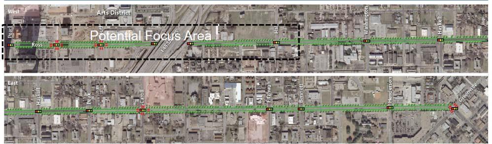
5 Potential Pilot Projects Opportunities to engage the community in exploring new complete street design concepts on specific streets Real case studies to provide input to the Complete Streets Design Manual Conceptual designs and rough cost estimates to enable pilot projects to be considered for funding through the 2012 Bond Program and other sources 4

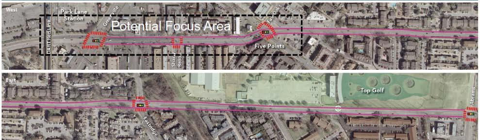
6 Potential Pilot Projects Project District Alpha Road 11 Buckner Boulevard 5 Camp Wisdom Drive 8 Davis Street 1,3 Grand Avenue 7 Henderson Avenue 2 Knox Street 14 Lancaster Road 4,5 Meadowcreek Drive 12 Northcliff Drive 9 Ross Avenue 14,2 Royal Lane 6,13 Skillman Street 10 Park Lane 13 Pearl Street 14 5


7 Community Workshops Community workshops focused on potential pilot projects held in November and December 2011 at seven locations throughout the city Variety of activities and interactive ways to provide input Over 375 community participants provided input on desired street improvements 6

8 Channel 8 News Video Clip Davis Street Workshop 7
9 Preliminary Design Concepts for Potential Pilot Projects Community input on desired improvements and preferences for street design elements was used to guide preliminary design concepts The following preliminary design concepts for the potential pilot projects are works in progress and will be modified and refined based on further community input If funding for implementation is secured, there will be additional opportunities for community input through detailed design and the Thoroughfare Plan amendment process 8
10 Priority Design Elements Alpha Road Low Medium High 9
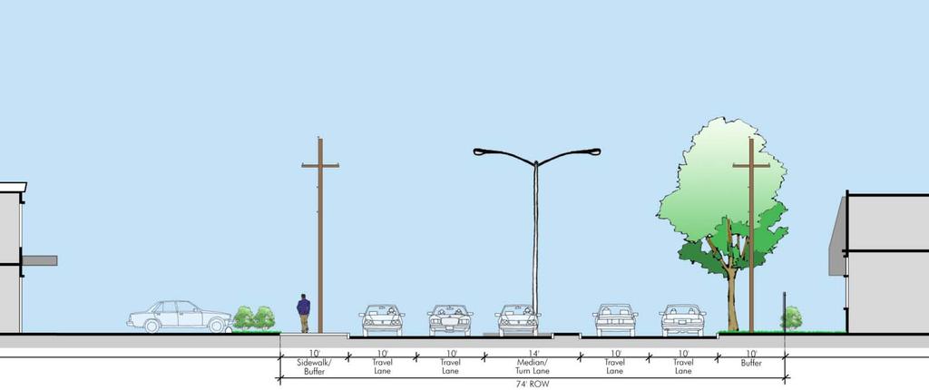
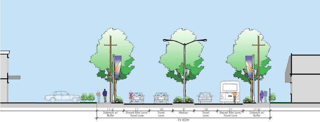
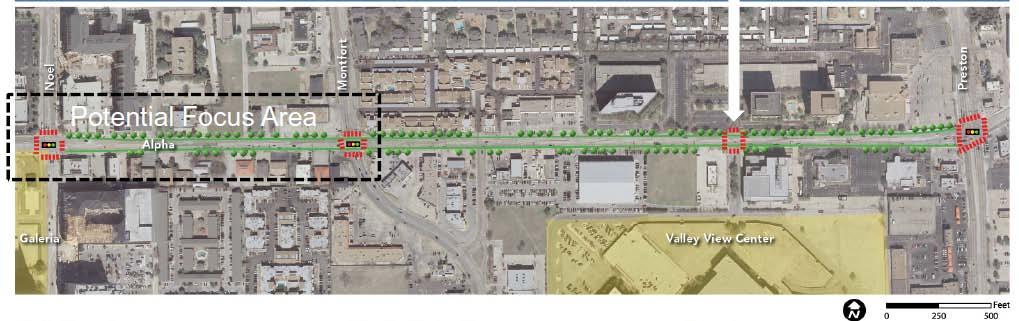
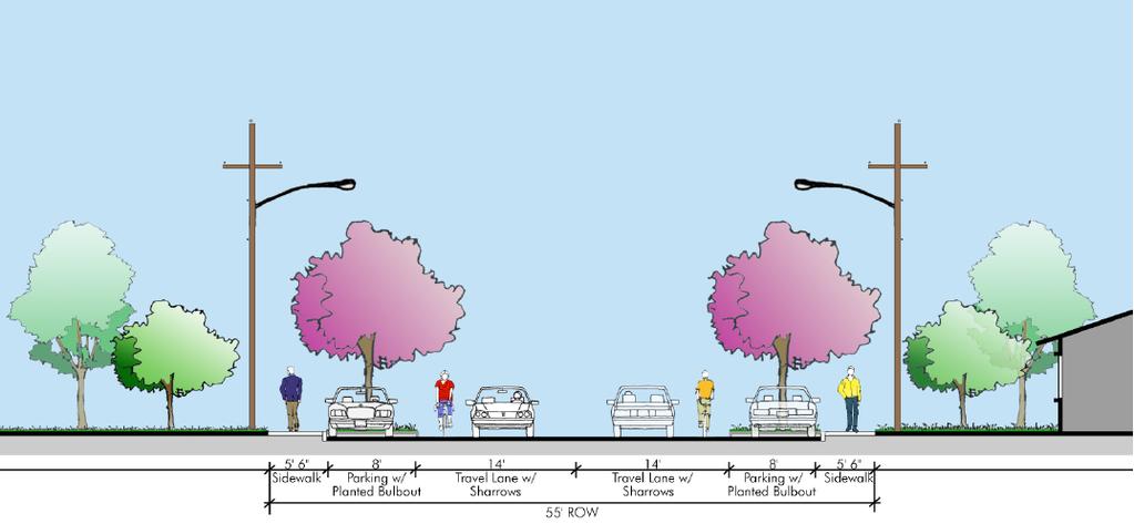
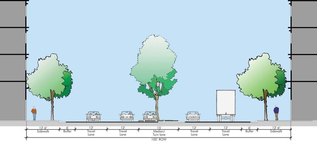
11 Preliminary Design Concepts Alpha Road 10
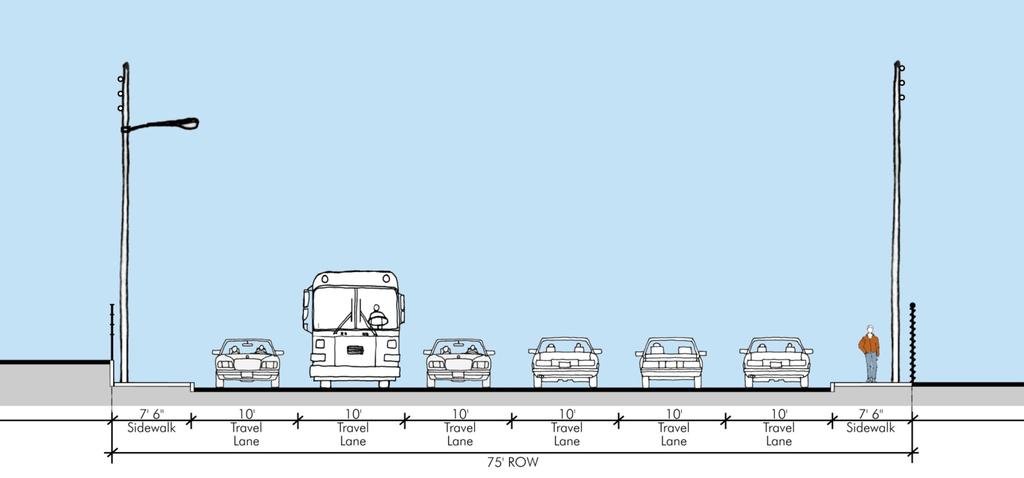
12 Priority Design Elements Buckner Boulevard Low Medium 11
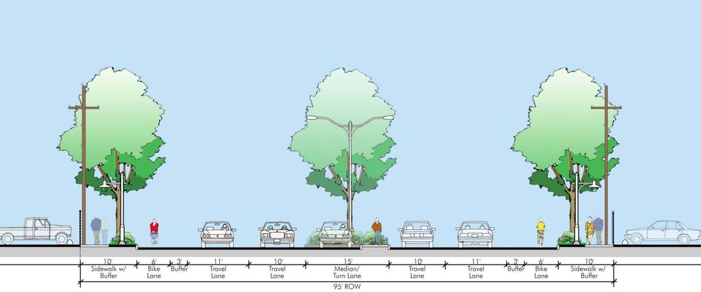
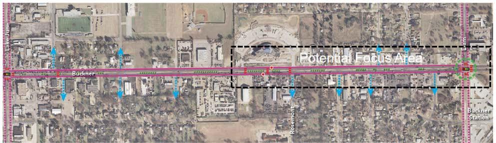
13 Preliminary Design Concepts Buckner Blvd Eastfield College 12
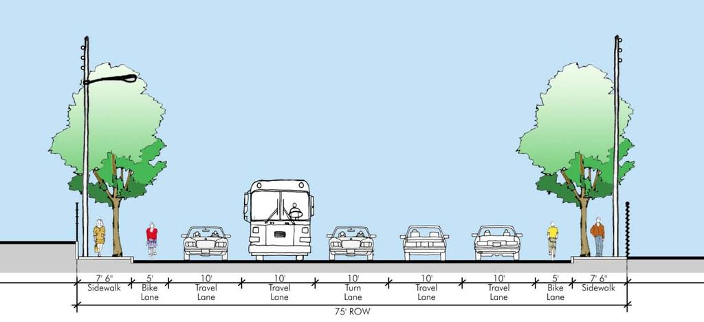
14 Priority Design Elements Camp Wisdom Road Low Medium High 13


15 Preliminary Design Concepts Camp Wisdom Proposed DART Station UNT-Dallas Campus 14
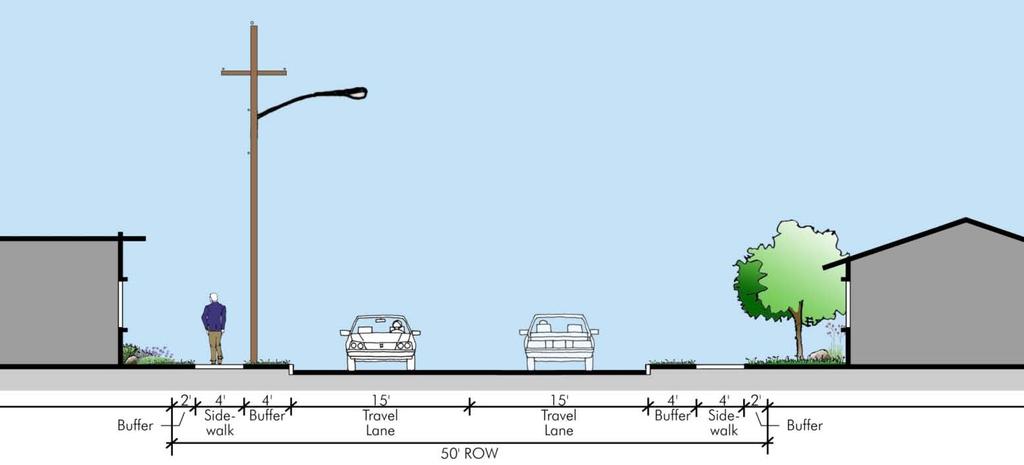
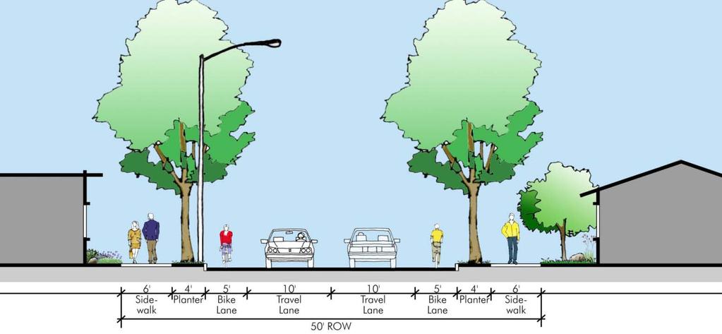
16 Priority Design Elements Davis Street Low Medium High 15
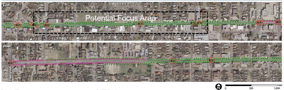
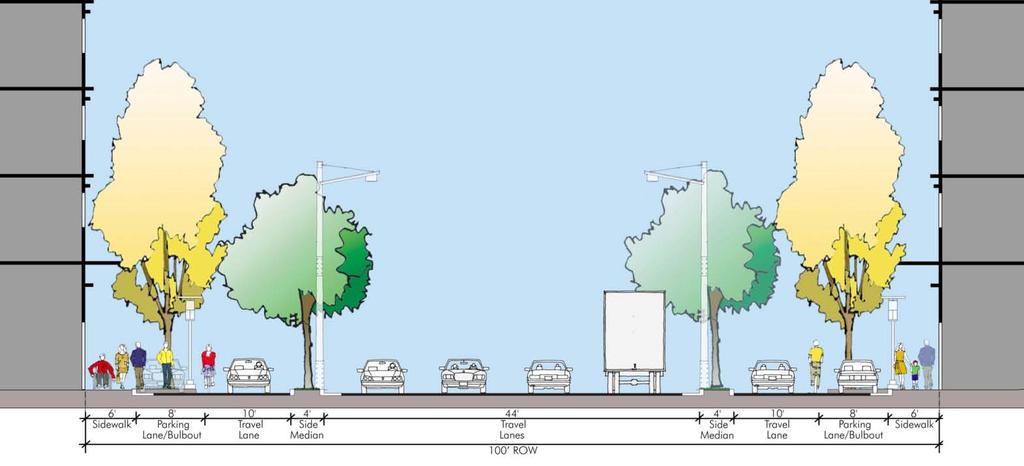
17 Preliminary Design Concepts Davis Street Bishop Arts District 16
18 Priority Design Elements Grand Avenue Low Medium High 17


19 Preliminary Design Concepts Grand Avenue New Billy Dade Middle School Site 18
20 Priority Design Elements Knox and Henderson Low Medium High 19
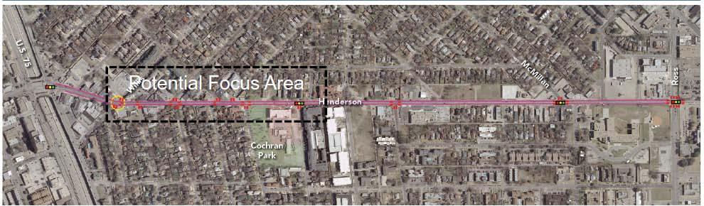
21 Preliminary Design Concepts Henderson Avenue 20
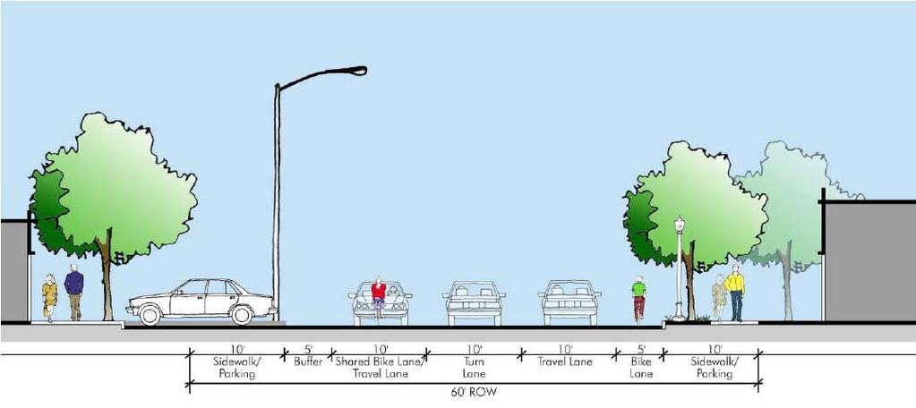
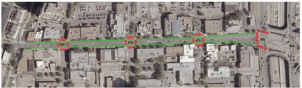
22 Preliminary Design Concepts Knox Street 21
23 Priority Design Elements Lancaster Road Low Medium 22


24 Preliminary Design Concepts Lancaster Road 23
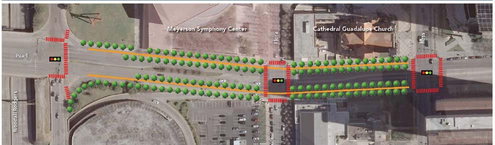
25 Priority Design Elements Meadowcreek Road Meadowcreek Road Low Medium High 24
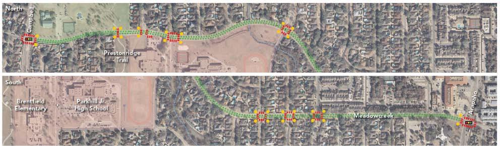
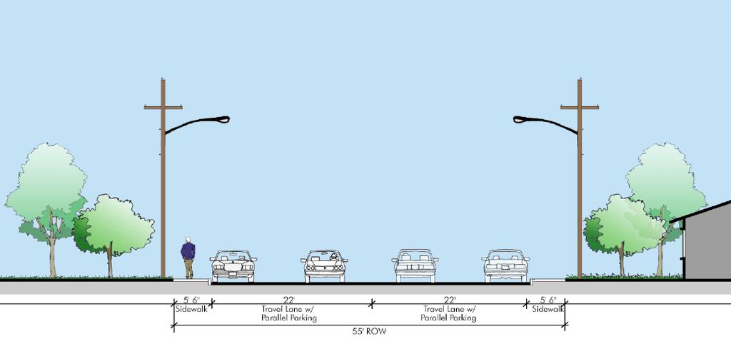
26 Preliminary Design Concepts Meadowcreek Road DRAFT 25
27 Priority Design Elements Northcliff Road Low Medium 26


28 Preliminary Design Concepts Northcliff Road 27
29 Priority Design Elements Park Lane Low Medium High 28
30 Preliminary Design Concepts Park Lane 29
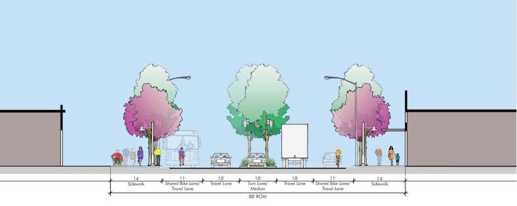
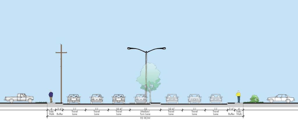
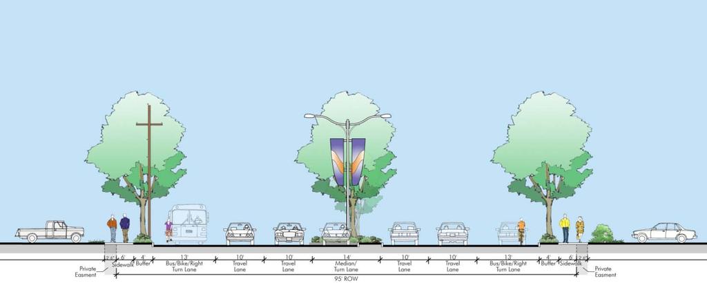
31 Priority Design Elements Ross Avenue and Pearl Street Low Medium High 30
32 Preliminary Design Concepts Pearl Street 31
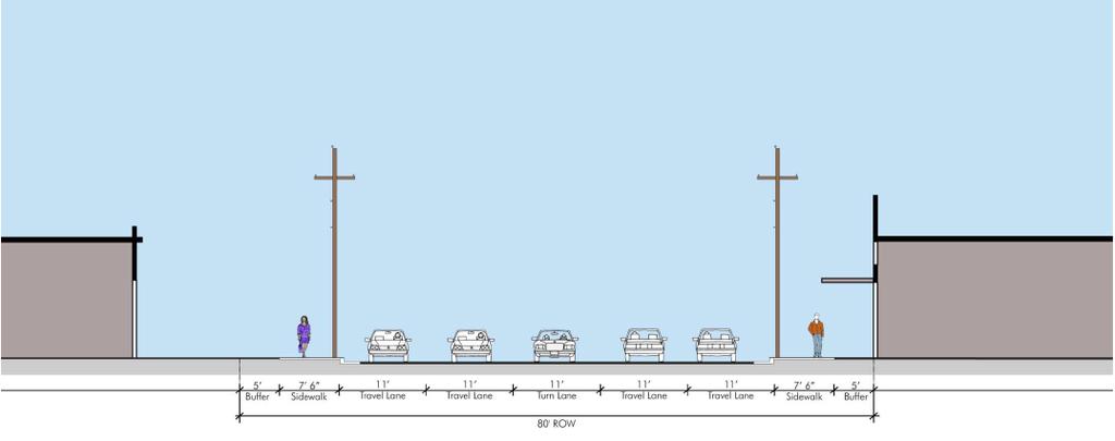
33 Preliminary Design Concepts Ross Avenue 32
34 Priority Design Elements Royal Lane Low Medium 33
35 Preliminary Design Concepts Royal Lane 34
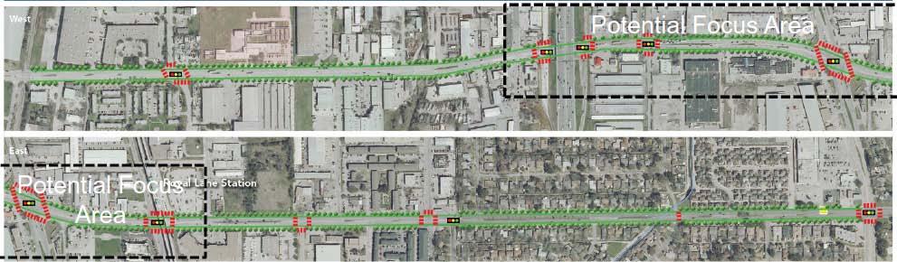
36 Priority Design Elements Skillman Road Low Medium 35
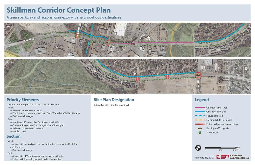
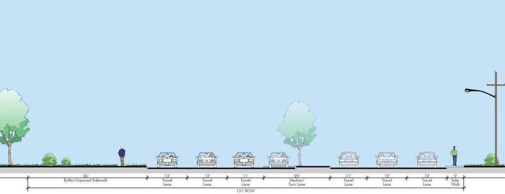
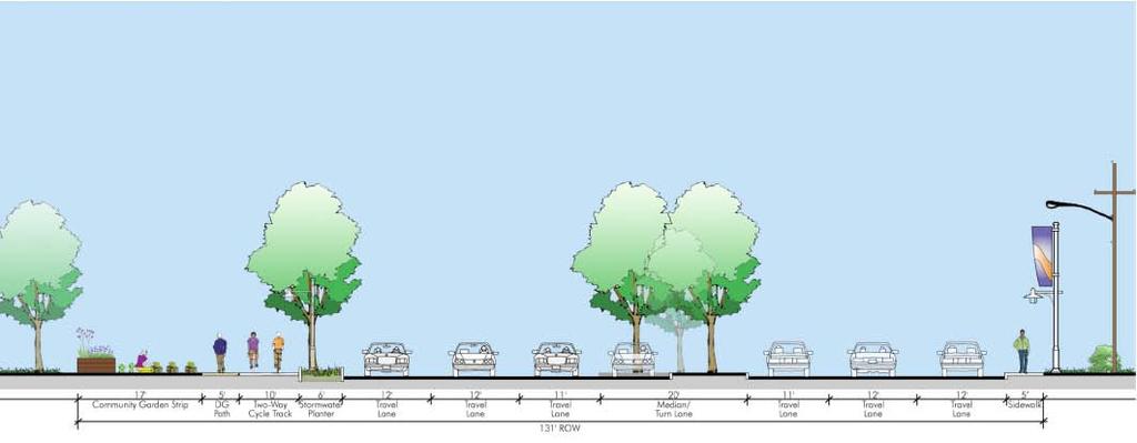
37 Preliminary Design Concepts Skillman Street 36
38 Preliminary Cost Estimates Design concepts focus improvements within existing right-of-way to avoid land acquisition Typical costs included: Sidewalks and sidewalk landscaping Enhanced crosswalks Pedestrian lighting Medians and median landscaping (where relevant) Bike facilities Lane restriping (where necessary) Typical costs not included: Roadway reconstruction and resurfacing Burying overhead utilities (electrical, phone, cable) Potential maintenance cost increase 37
39 Preliminary Capital Cost Estimates Corridor Length (miles) Cost(millions) Alpha Road 0.83 $ 2.4 Buckner Boulevard 1.04 $ 2.1 Camp Wisdom Drive 3.60 $ 1.8 Davis Street 1.80 $ 1.6 Grand Avenue 0.85 $ 2.0 Henderson Avenue 1.16 $ 1.6 Knox Street 0.30 $ 0.6 Lancaster Road 1.68 $ 3.8 Meadowcreek Road 1.25 $ 1.8 Northcliff Road 1.16 $ 0.9 Park Lane 1.29 $ 4.3 Pearl Street 0.18 $ 2.9 Ross Avenue 2.08 $ 5.3 Royal Lane 2.39 $ 6.0 Skillman Road 1.86 $ 1.9 Total $
40 Potential Phased Approach Staff can explore cost reduction through a phased approach: Limit higher cost design elements to the identified focus areas within each corridor: Enhanced/wider sidewalks and sidewalk landscaping Enhanced crosswalks Pedestrian lighting median landscaping Include moderate cost elements for full corridor extents Bike facility street markings Basic sidewalk improvements and crosswalk markings 39
41 Funding Considerations These Complete Street pilot projects will be included in the City of Dallas Needs Inventory for consideration in the 2012 Bond Program Projects to be proposed in the 2012 Bond package will be determined by City Council priorities Potential opportunities for collaborations with Dallas County, DART and TXDOT to be explored Public-private partnership opportunities to be explored for handling the increased operation and maintenance responsibilities associated with complete street enhancements 40
42 Partnership Opportunities Collaboration with DART on enhanced transit stops and related improvements Opportunities for collaboration with Dallas County Opportunities to work with Public Improvement Districts (PIDs) and other public/private entities to partner on sharing capital and operation and maintenance costs. 41
43 Other Complete Street Projects The following additional complete street projects in need of funding are also under consideration for the Bond Program Additional Complete Street Projects District Bishop from Jefferson to 8 th * 1 Main Street from Good Latimer to Exposition * 2 Commerce Street from Good Latimer to Exposition * 2 Greenville from Belmont to Bell and from Alta to Ross 2, 14 Fort Worth Avenue from Westmoreland to Beckley ** 3, 6 M.L.K. from R.B. Cullum to S.M. Wright 7 M.L.K. from S.M. Wright to Gould 7 S. Pearl Street from Canton Street to Marilla Street 14 * Detailed design for these projects is already funded and underway ** Conceptual design for this project is funded and underway 42
44 Complete Streets Initiative Next Steps Conduct two temporary demonstration projects to test feasibility of alternative complete street roadway configurations in real conditions and get additional community input Draft Complete Streets Design Manual for technical review Explore alternative funding options for pilot project implementation 43
45 Complete Streets Initiative Update UrbanAdvantage Council Transportation and Environment Committee April 23, 2012
BICYCLE PROGRAM IMPLEMENTATION UPDATE. Transportation and Trinity River Project Council Committee June 13, 2016
 BICYCLE PROGRAM IMPLEMENTATION UPDATE Transportation and Trinity River Project Council Committee Purpose 01 Provide background and a status update on onstreet bicycle facility planning and implementation
Memorandum. Bike Plan Implementation and Thoroughfare Plan Amendment Process
 Memorandum DATE December 9, 201 1 CITY OF DALLAS TO SUBJECT Honorable Members of the Quality of Life & Government Services Committee: Angela Hunt (Chair), Sandy Greyson (Vice Chair), MOnica R. Alonzo,
Henderson Ave. Complete Streets Project
 Henderson Ave. Complete Streets Project Meeting Purpose To finalize conceptual components of project prior to proceeding with preliminary engineering www.dallascompletestreets.wordpress.com MeetingAgenda
Dallas Bike Plan Implementation
 Dallas Bike Plan Implementation UrbanAdvantage Council Transportation and Environment Committee February 13, 2012 Purpose Review the adopted Dallas Bike Plan Implementation Strategy and current status
DALLAS MIDTOWN REDEVELOPMENT PLAN FOCUS NORTH TEXAS Peer Chacko, AICP, Assistant Director, City of Dallas
 DALLAS MIDTOWN REDEVELOPMENT PLAN FOCUS NORTH TEXAS 2014 Peer Chacko, AICP, Assistant Director, City of Dallas Dallas Midtown: Strategic growth area Future transit node 2 Peterson Road Study Area Galleria
LANE ELIMINATION PROJECTS
 PRESENTATION OUTLINE Lane Elimination Considerations Districts 4 & 7 Draft Lane Elimination Processes FDOT Lane Elimination Guidelines Example Projects D4 Case Study: SR A1A (Ft. Lauderdale) D7 Case Study:
Commerce Street Complete Street Project from Good Latimer Expressway to Exposition Avenue
 Commerce Street Complete Street Project from Good Latimer Expressway to Exposition Avenue T A N Y A B R O O K S A S S I S T A N T D I R E C T O R M O B I L I T Y P L A N N I N G M O B I L I T Y A N D S
Chapter 4: Funding and Implementation
 Chapter 4: Funding and Implementation 83 84 Cost Estimating Cost estimating is an iterative process. When a project is in the conceptual stage, preliminary cost estimates are also provided conceptually,
TULSA CITY COUNCIL CAPITAL IMPROVEMENT PROGRAM TASK FORCE MEETING JANUARY
 CITY OF TULSA BICYCLE & PEDESTRIAN INFRASTRUCTURE TULSA CITY COUNCIL CAPITAL IMPROVEMENT PROGRAM TASK FORCE MEETING JANUARY 31, 2013 CITY OF TULSA ENGINEERING SERVICES DEPARTMENT CITY OF TULSA ADA TRANSITION
Beach Cities Living Streets Design Manual and Aviation Boulevard Multimodal Corridor Plan
 Beach Cities Living Streets Design Manual and Aviation Boulevard Multimodal Corridor Plan AGENDA 1 Introductions & Project Scope 2 Public Outreach Recap 3 Living Streets Design Manual 4 Aviation Boulevard
122 Avenue: 107 Street to Fort Road
 : 107 Street to Fort Road November 24, 2015 4:30 8:00 p.m. Meeting Purpose Summarize project work completed to date Share results of public input from Phase 1 Share the draft concept plan and proposed
Saskatchewan Drive Roadway Rehabilitation and Shared-Use Path Widening
 Saskatchewan Drive Roadway Rehabilitation and Shared-Use Path Widening We are here today to present the draft plan for the Saskatchewan Drive Roadway Rehabilitation and Shared-Use Path Widening project
Dr. M.L. King, Jr. Street North Complete Streets Resurfacing Opportunities HOUSING, LAND USE, AND TRANSPORTATION COMMITTEE MARCH 22, 2018
 Dr. M.L. King, Jr. Street North Complete Streets Resurfacing Opportunities HOUSING, LAND USE, AND TRANSPORTATION COMMITTEE MARCH 22, 2018 What s Happening The City plans to mill and resurface Dr. M.L.
Proposed. City of Grand Junction Complete Streets Policy. Exhibit 10
 Proposed City of Grand Junction Complete Streets Policy Exhibit 10 1 City of Grand Junction Complete Streets Policy Vision: The Complete Streets Vision is to develop a safe, efficient, and reliable travel
Environment and Public Works Committee Presentation
 Mixed Use Centers Complete Streets Guidelines Project Environment and Public Works Committee Presentation December 10, 2008 Project Objectives: Conduct an inter-departmental and agency process to study
Hennepin Avenue Reconstruction Washington Avenue to 12 th Street
 CITY OF MINNEAPOLIS Hennepin Avenue Reconstruction Washington Avenue to 12 th Street April 2016 1 Upcoming Opportunities Public Meeting #2 April 25, 2016 Minneapolis Central Library Doty Board Room Repeat
MEETING OF THE CITY OF CONCORD BICYCLE, PEDESTRIAN AND SAFE ROUTES TO TRANSIT PLAN ADVISORY COMMITTEE AGENDA
 MEETING OF THE CITY OF CONCORD BICYCLE, PEDESTRIAN AND SAFE ROUTES TO TRANSIT PLAN ADVISORY COMMITTEE Monday, April 25, 2016 5:30 p.m., Regular Meeting PERMIT CENTER CONFERENCE ROOM 1950 Parkside Drive,
Lincoln Neighborhood Corridor Plan The LiNC
 CITY OF SANTA MONICA Lincoln Neighborhood Corridor Plan The LiNC PLANNING COMMISSION September 2, 2015 COMMUNITY DESIGN + ARCHITECTURE TEAM: Community Design + Architecture Iteris Studio 111 Urban Place
Living Streets Policy
 Living Streets Policy Introduction Living streets balance the needs of motorists, bicyclists, pedestrians and transit riders in ways that promote safety and convenience, enhance community identity, create
Road Diets FDOT Process
 Florida Department of TRANSPORTATION Road Diets FDOT Process Humberto Castillero, PE, PTOE Roadway Design Office Purpose of Guide Develop a statewide lane elimination review process Balance state & local
Lee s Summit Road Improvement Study Public Open House June 7, 2007 Summary of Comment Card Responses
 Lee s Summit Road Improvement Study Public Open House June 7, 2007 Summary of Comment Card Responses Introduction At the Lee s Summit Road Improvement Study Public Open House held Thursday, June 7, 2007
Hennepin County Transportation Department
 Hennepin County Transportation Department Complete Streets Design and Implementation Prepared for the Complete Streets Task Force Craig Twinem, P.E. Design Division Manager Tom Johnson, P.E. Transportation
83 AVENUE PRE-CONSTRUCTION MEETING
 83 AVENUE PRE-CONSTRUCTION MEETING April 6, 2017 5-8PM Please visit displays for project information Talk to staff, ask questions, visit website at: www.edmonton.ca/bike83avenue Pre-Construction Meeting
ADA TRANSITION PLAN 2013
 ADA TRANSITION PLAN 2013 TABLE OF CONTENTS Contents Introduction 1 Purpose 2 Identified Obstacles to the Public Right of Way 3 Criteria for Determining Impediments at Village Facilities 4 Removing Barriers
Knox Street Complete Streets Project
 Knox Street Complete Streets Project Meeting Purpose Get community feedback on two conceptual street design options Meeting Agenda Presentation (20 minutes) Project background and schedule Summary of preferences
Mayor s Bicycle Advisory Council. Wednesday, December 13 th, 2017
 Mayor s Bicycle Advisory Council Wednesday, December 13 th, 2017 Bicyclist Fatalities, Year to Date (January 1 November 30, 2017) - MBAC Briefing Bicyclist Fatality Statistics Year to date total, 2017
Tonight is for you. Learn everything you can. Share all your ideas.
 Strathcona Neighbourhood Renewal Draft Concept Design Tonight is for you. Learn everything you can. Share all your ideas. What is Neighbourhood Renewal? Creating a design with you for your neighbourhood.
APPENDIX A: Complete Streets Checklist DRAFT NOVEMBER 2016
 APPENDIX A: Complete Streets Checklist DRAFT NOVEMBER 2016 Complete Streets Checklist MetroPlan Orlando s Complete Streets Checklist is an internal planning tool for staff to further implementation of
North Shore Transportation Improvement Strategy
 North Shore Transportation Improvement Strategy Preliminary, Near-term Recommendation 2016 April Transportation Improvement Strategy (TIS) Comprehensive and Analytical A multi-modal transportation strategy
DISTRICT BICYCLE PROGRAM
 DISTRICT BICYCLE PROGRAM TxDOT Fort Worth District Public Hearing Bicycle Use on the State Highway System Public Hearing Agenda 1 2 3 4 5 6 Introduction Susan Howard TxDOT Public Involvement Specialist
Stakeholder Update. Agenda. Project update Needs Identification Strategy Proposed needs Safety Collectors/Arterials Greenways Local roads
 1 Stakeholder Update May 21, 2018 2 Agenda Project update Needs Identification Strategy Proposed needs Safety Collectors/Arterials Greenways Local roads Proposed Evaluation Criteria Next Steps 1 Project/Schedule
Fulton Market Streetscape
 Fulton Market Streetscape Ogden Avenue to Halsted Street Public Meeting Recommended Improvements December 10th, 2014 Meeting Purpose and Goals Present Existing Conditions Community Input and Charrette
Omaha s Complete Streets Policy
 Omaha s Complete Streets Policy (Adopted August 2015) VISION To create great places and enhance our quality of life, the City of Omaha will provide safe, accessible streets for all users. Complete Streets
City of San Diego Vision Zero Draft Strategic Plan FY 2017
 City of San Diego Vision Zero Draft Strategic Plan FY 2017 Engineering Objective: To develop and implement a strategy that employs best planning, design and engineering practices. Background: Over the
Rebuilding Highway 7 Town Centre Boulevard to Sciberras Road
 Rebuilding Highway 7 Town Centre Boulevard to Sciberras Road Project Status Update Presentation to City of Markham Development Services Committee October 22, 2013 Presentation Outline Background Status
MnDOT Implementation of Complete Streets Policy. January 2014
 MnDOT Implementation of Complete Streets Policy January 2014 1 Prepared by Minnesota Department of Transportation 395 John Ireland Boulevard Saint Paul, Minnesota 55155-1899 Phone: 651-296-3000 Toll-Free:
Southcote Road Improvements Class Environmental Assessment Study
 1 Southcote Road Improvements Class Environmental Assessment Study Public Information Centre #1 May 24, 2018 Study Area 2 3 Welcome The Ancaster Transportation Master Plan (2011) outlined a long range
ACTIVE TRANSPORTATION/NONMOTORIZED TRANSPORTATION
 ACTIVE TRANSPORTATION/NONMOTORIZED TRANSPORTATION BACKGROUND Active transportation, also known as nonmotorized transportation, is increasingly recognized as an important consideration when planning and
RESOLUTION NO ?? A RESOLUTION OF THE CITY OF NEPTUNE BEACH ADOPTING A COMPLETE STREETS POLICY
 RESOLUTION NO. 2018-?? A RESOLUTION OF THE CITY OF NEPTUNE BEACH ADOPTING A COMPLETE STREETS POLICY WHEREAS, safe, convenient, and accessible transportation for all users is a priority of the City of Neptune
Paoli Road Improvement Feasibility Study
 Paoli Road Improvement Feasibility Study & Public Participation Project March 24, 2015 Prepared for: Tredyffrin Township Prepared by: McMahon Associates, Inc. with Town Planning Partnership, LLC Glackin
Chapter 3 BUS IMPROVEMENT CONCEPTS
 Chapter 3 BUS IMPROVEMENT CONCEPTS The purpose of this chapter is to describe potential bus improvement strategies and potential impacts or implications associated with BRT implementation within the existing
Prince George s County plans, policies, and projects
 Prince George s County plans, policies, and projects Over 250 projects for trails, bikeways, designated bike lanes and sidewalk construction Trail projects that improve access to Metro Sidewalk and trail
Application of a Complete Street
 Application of a Complete Street Southbend to Prima Vista Update May 14, 2018 Meeting Agenda Perspective and History Public input received Typical sections being considered Presentation of the 2-lane master
42nd Ave N Reconstruction
 CITY OF MINNEAPOLIS 42nd Ave N Reconstruction Community Meeting #2 May 2016 6:00 7:30 p.m. 5/16/2016 1 Purpose of Meeting Inform: Provide an overview of project, identify anticipated scope of work, and
Pennsylvania Avenue (CR 484) Design Alternatives Study
 Design Alternatives Study") MEMORANDUM Pennsylvania Avenue (CR 484) Design Alternatives Study Prepared for: APRIL 2016 Prepared By TABLE OF CONTENTS Project Background... 2 Previous Concept... 2 Existing Conditions... 4 New Alternatives...
MEMORANDUM Pennsylvania Avenue (CR 484) Design Alternatives Study Prepared for: APRIL 2016 Prepared By TABLE OF CONTENTS Project Background... 2 Previous Concept... 2 Existing Conditions... 4 New Alternatives...
ADA Transition Plan. City of Gainesville FY19-FY28. Date: November 5, Prepared by: City Of Gainesville Department of Mobility
 ADA Transition Plan FY19-FY28 Date: November 5, 2018 Prepared by: City Of Gainesville Department of Mobility 1.0 INTRODUCTION 1.1 BACKGROUND The federal statute known as the Americans with Disabilities
Corpus Christi Metropolitan Transportation Plan Fiscal Year Introduction:
 Introduction: The Safe, Accountable, Flexible, Efficient Transportation Equity Act: A Legacy for Users (SAFETEA-LU) has continued the efforts started through the Intermodal Surface Transportation Efficiency
Board of Supervisors February 27, 2017
 : Traffic Analysis Results & Draft Conceptual Plan Board of Supervisors February 27, 2017 Transportation Solutions Building Better Communities Presentation Overview Background Summary of Traffic Analysis
General Plan Circulation Element Update Scoping Meeting April 16, 2014 Santa Ana Senior Center, 424 W. 3rd Street, Santa Ana, CA 92701
 General Plan Circulation Element Update Scoping Meeting April 16, 2014 Santa Ana Senior Center, 424 W. 3rd Street, Santa Ana, CA 92701 Meeting Agenda 1. Purpose of Scoping Meeting 2. Project Overview 3.
Draft Recommended List of Potential Projects
 Draft Recommended List of Potential Projects To Pursue Using the GID Fund Recommendations are based on results of public outreach, City Council discussion, and staff evaluation of all project ideas identified
University of Victoria Campus Cycling Plan Terms of Reference. 1.0 Project Description
 University of Victoria Campus Cycling Plan Terms of Reference 1.0 Project Description The Campus Cycling Plan, a first for the University, will provide a comprehensive and coordinated approach to support
SR 693 (Pasadena Avenue) Corridor Study from Shore Drive South to 66 th Street
 Corridor Study from Shore Drive South to 66 th Street") Welcome and Introduction Sign-in and comment sheets Restrooms and exits Meeting agenda and timeline Meeting goals / expectations Provide input to guide study recommendations Actively participate throughout
Welcome and Introduction Sign-in and comment sheets Restrooms and exits Meeting agenda and timeline Meeting goals / expectations Provide input to guide study recommendations Actively participate throughout
Executive Summary Route 30 Corridor Master Plan
 Route Corridor Master Plan Project Overview The Route Corridor Master Plan is a coordinated multimodal transportation and land use plan for the entire stretch of Route through East Whiteland Township,
Ann Arbor Downtown Street Plan
 1 Ann Arbor Downtown Street Plan Public Workshop #1 We know that. 2 Public right-of-way (streets, sidewalks, and alleys) make up 30% of the total District area of downtown. Streets need to provide mobility
2014/2015 BIKE ROUTE PLAN 83 AVENUE PROTECTED BIKE LANE
 About the Project 2014/2015 BIKE ROUTE PLAN The City of Edmonton is planning a major bike route on the south side of Edmonton. This bike route is one part of a plan to provide citizens with transportation
In station areas, new pedestrian links can increase network connectivity and provide direct access to stations.
 The Last Mile Planning for Pedestrians Planning around stations will put pedestrians first. Making walking to stations safe and easy is important; walking will be a part of every rapid transit Accessible
Geary Bus Rapid Transit Project
 Geary Bus Rapid Transit Project Urban Forestry Council Planning and Funding Committee Meeting September 13, 2016 SAN FRANCISCO COUNTY TRANSPORTATION AUTHORITY SAN FRANCISCO MUNICIPAL TRANSPORTATON AGENCY
APPROVE A RESOLUTION ADOPTING A COMPLETE STREETS POLICY
 STAFF REPORT MEETING DATE: September 13, 2016 TO: FROM: City Council Bob Brown, Community Development Director Russ Thompson, Public Works Director Patrick Filipelli, Management Analyst 922 Machin Avenue
Orange County s Transportation Planning and Multimodal Corridor Plan
 Orange County Transportation Planning Division Orange County s Transportation Planning and Multimodal Corridor Plan Presentation to UCF LIFE November 11, 2014 Alissa Barber Torres, Ph.D., AICP, PLS Presentation
REGIONAL BICYCLE AND PEDESTRIAN DESIGN GUIDELINES
 REGIONAL BICYCLE AND PEDESTRIAN DESIGN GUIDELINES November 16, 2011 Deb Humphreys North Central Texas Council of Governments Bicycle and Pedestrian Advisory Committee Snapshot of the Guide 1. Introduction
BETHEL ROAD AND SEDGWICK ROAD CORRIDOR STUDY
 DRAFT PLAN City Council Meeting August 14, 2017 STUDY AREA Sedgwick Corridor State Route 160, principal arterial with Class 3 access management designation, commuter and freight route, connection to SR
2014/2015 BIKE ROUTE PLAN 83 AVENUE PROTECTED BIKE LANE
 About the Project The City of Edmonton is planning a major bike route on the southside of Edmonton. The Strathcona Bike Route will connect the communities of Strathcona, Garneau and the University area,
COMPLETE STREETS A STEP FORWARD ITE District 10/FSITE Annual Meeting November 3, 2015
 COMPLETE STREETS A STEP FORWARD 2015 ITE District 10/FSITE Annual Meeting November 3, 2015 About Lakeland Incorporated: 1885 Population: 100,728 Area: Approx. 75 sq. mi Major Employers: Publix, Lakeland
DULLES AREA TRANSPORTATION ASSOCIATION (DATA) February 18, Susan Shaw, P.E., VDOT, Megaprojects Director
 February 18, Susan Shaw, P.E., VDOT, Megaprojects Director") DULLES AREA TRANSPORTATION ASSOCIATION (DATA) February 18, 2015 Susan Shaw, P.E., VDOT, Megaprojects Director I-66 Corridor Conditions Steady population growth Employment growth in activity centers Congestion
DULLES AREA TRANSPORTATION ASSOCIATION (DATA) February 18, 2015 Susan Shaw, P.E., VDOT, Megaprojects Director I-66 Corridor Conditions Steady population growth Employment growth in activity centers Congestion
Broward Boulevard Gateway Implementation Project, Downtown Walkability Analysis, & Joint Development Initiative (JDI)
") Broward Boulevard Gateway Implementation Project, Downtown Walkability Analysis, & Joint Development Initiative (JDI) City of Fort Lauderdale ~ Commission Conference July 10, 2012 Page 1 of 15 A Multi-Agency
Broward Boulevard Gateway Implementation Project, Downtown Walkability Analysis, & Joint Development Initiative (JDI) City of Fort Lauderdale ~ Commission Conference July 10, 2012 Page 1 of 15 A Multi-Agency
Feasibility Study of Pedestrian Crossings Along Route 7, East of Cascades Parkway and West of Dranesville Road. October 3, 2017
 Feasibility Study of Pedestrian Crossings Along Route 7, East of Cascades Parkway and West of Dranesville Road October 3, 2017 Study Area (area within a ¼-mile radius of the study intersections) Route
MAG Town of Cave Creek Bike Study Task 6 Executive Summary and Regional Significance Report
 Page 1 MAG Town of Cave Creek Bike Study Task 6 Executive Summary and Regional Significance Report August 1, 2012 MAG Project #481 Page 2 Task 6 Executive Summary and Regional Significance Report Introduction
Presentation Outline. Project/Study Purpose. Existing Conditions. Future Conditions. Understanding the Streetside. Similar Walkable Environments
 Presentation Outline Project/Study Purpose Study Area Map Existing Conditions Future Conditions Understanding the Streetside Similar Walkable Environments Conceptual Alternatives Magnolia/NE 1st Ave Block
Pre-Construction Meeting
 Pre-Construction Meeting Wednesday, March 21 Drop-in from 5 9pm Please visit displays for project information, talk to staff, and ask questions! Edmonton.ca/SouthsideBikeRoutes Objectives & Project Scope
Traffic Improvements for the Transit Oriented Development District (TODD) Meriden Public Library March 11, 2014
 Meriden Public Library March 11, 2014") Traffic Improvements for the Transit Oriented Development District (TODD) Meriden Public Library March 11, 2014 Project Overview Coordinate roadway improvements with other major projects HUB Flood Control
Traffic Improvements for the Transit Oriented Development District (TODD) Meriden Public Library March 11, 2014 Project Overview Coordinate roadway improvements with other major projects HUB Flood Control
Road Diets: Reconfiguring Streets for Multi-Modal Travel
 Road Diets: Reconfiguring Streets for Multi-Modal Travel Tom Grant, P.E., PTOE What is a Road Diet? Reconfiguration of travel lanes to benefit all roadway users (i.e., Complete Street) Reclaiming the space
CITY OF BLOOMINGTON COMPLETE STREETS POLICY
 CITY OF BLOOMINGTON COMPLETE STREETS POLICY POLICY OBJECTIVE: The City of Bloomington will enhance safety, mobility, accessibility and convenience for transportation network users of all ages and abilities,
BD RESOLUTION NO RESOLUTION ADOPTING THE VISION ZERO RAMP INTERSECTION STUDY PHASE 1
 BD00 RESOLUTION NO. - RESOLUTION ADOPTING THE VISION ZERO RAMP INTERSECTION STUDY PHASE [NTIP PLANNING] FINAL REPORT WHEREAS, The Vision Zero Ramp Intersection Study Phase was recommended by Commissioner
WALKNBIKE DRAFT PLAN NASHVILLE, TENNESSEE EXECUTIVE SUMMARY NASHVILLE, TENNESSEE
 NASHVILLE, TENNESSEE EXECUTIVE SUMMARY Executive Summary A world-class multi-modal transportation system is essential to a vibrant city and better quality of life. -Mayor Barry The WalknBike plan aims
BIKE PLAN CONTENTS GATEWAY
 CONTENTS Acknowledgments...vii Great Rivers Greenway District Board of Directors... vii Great Rivers Greenway District Staff... vii Project Consultants... vii Committees... viii Citizens Advisory Committee
Southeast-1 Stations: ALIGNMENT OVERVIEW
 Southeast-1 Stations: ALIGNMENT OVERVIEW Street Reconstruction Schedule Proposed Schedule Street Name Traffic Flow During Construction Estimated Completion Date Good Latimer See Maps Sept. 2008 Gaston
System Performance Innovation FACT Sheet Hawk Pedestrian Beacon
 Hawk Pedestrian Beacon Description of the Challenge or Opportunity Hawk Pedestrian Beacon Understanding the motivation. Describe the pre-existing product/process that is the subject of the innovation:
Ocean Park Boulevard Green Street Project Community Workshop
 Ocean Park Boulevard Green Street Project Community Workshop 2.2.10 Project Objectives Community Priority: reclaim OPB for public open space. Build upon LUCE principles; neighborhood enhancement, connectivity,
Arterial Transitway Corridors Study. Ave
 Arterial Transitway Corridors Study Ave January 2012 Arterial Transitway Corridors Study Overview Corridor Features and Demographics 11 study corridors, 95 route miles 86,000 daily rides and half of existing
MONTCLAIR SAFE COMPLETE STREETS IMPLEMENTATION PLAN. Monday November 13, 2017 Michael Dannemiller, Principal Engineer NV5, Inc.
 MONTCLAIR SAFE COMPLETE STREETS IMPLEMENTATION PLAN Monday November 13, 2017 Michael Dannemiller, Principal Engineer NV5, Inc. PROJECT TEAM THE OFFICE OF BICYCLE AND PEDESTRIAN PROGRAMS, NEW JERSEY DEPARTMENT
Bicycle Lanes Planning, Design, Funding South Mountain Partnership Trails Workshop Roy Gothie PennDOT Statewide Bicycle Pedestrian Coordinator
 Bicycle Lanes Planning, Design, Funding 2018 South Mountain Partnership Trails Workshop Roy Gothie PennDOT Statewide Bicycle Pedestrian Coordinator Policy Changes: BOP Bicycle Policy Changes The OLD Way
Hospital Link Project Project Update September 2017
 Hospital Link Project Project Update September 2017 General The project provides a link from Riverside Drive and the Transitway to the Hospital Link Road. Construction is well underway. Read on for important
Strategies for Maintaining & Renewing Innovative Street Projects. Elyse Parker, Director of Policy & Innovation, City of Toronto NACTO, LA, 2018
 Strategies for Maintaining & Renewing Innovative Street Projects Elyse Parker, Director of Policy & Innovation, City of Toronto NACTO, LA, 2018 1 OUR ASSETS $12B in Assets $20B Replacement Cost $372M Capital
CHAPTER 7.0 IMPLEMENTATION
 CHAPTER 7.0 IMPLEMENTATION Achieving the vision of the Better Streets Plan will rely on the ability to effectively fund, build and maintain improvements, and to sustain improvements over time. CHAPTER
VIII. Project Prioritization & Implementation
 Transportation Plan 2030 July 2006 VIII. Project Prioritization & Implementation Public Transit Service Investigation into the development of a demand responsive service route system through a process
PEDESTRIAN ACTION PLAN
 ATTACHMENT 2 CITY OF SANTA MONICA PEDESTRIAN ACTION PLAN CITY OF SANTA MONICA PEDESTRIAN ACTION PLAN This page intentionally left blank EXECUTIVE SUMMARY CHAPTER 1 EXECUTIVE SUMMARY Setting the Stage
Project Status Update
 Project Status Update : Novato Boulevard, 4th & 3rd Streets, Sir Francis Drake Boulevard (3), and Miller Avenue Major roads projects target the most heavily traveled roads in Marin County for repairs,
Americans with Disabilities Act Transition Plan for Public Right-of-Way Improvements
 Americans with Disabilities Act Transition Plan for Public Right-of-Way Improvements Prepared by: Public Works Department Engineering Division October 2015 Table of Contents Section I Introduction.. 3
Presentation Starts at 5:30 PM
 Presentation Starts at 5:30 PM Public Meeting #1 September 22, 2016 Purpose of Study Conceptual Complete Streets Study on South Carson Street 5 th Street to Roland Drive Approximately 2.5 miles Consider
CRESTON ROAD COMPLETE AND SUSTAINABLE STREETS CORRIDOR PLAN
 CRESTON ROAD COMPLETE AND SUSTAINABLE STREETS CORRIDOR PLAN Preferred Plan Community Presentation September 27, 2017 City of El Paso de Robles in partnership with: Local Government Commission, W-Trans,
Bicycle Master Plan Goals, Strategies, and Policies
 Bicycle Master Plan Goals, Strategies, and Policies Mobilizing 5 This chapter outlines the overarching goals, action statements, and action items Long Beach will take in order to achieve its vision of
Technical Working Group November 15, 2017
 Technical Working Group November 15, 2017 Welcome and Introductions Project Partners Regional Transportation District (RTD) Colorado Department of Transportation (CDOT) Denver Regional Council of Governments
forwarddallas! Implementation Proposed Chapter 43 Code Amendment On-Street Parking
 forwarddallas! Implementation Proposed Chapter 43 Code Amendment On-Street Parking Transportation and Environment Committee Briefing December 10, 2007 PURPOSE Code amendment to establish regulations consistent
Central Avenue Corridor Study FPID Number:
 Central Avenue Corridor Study FPID Number: 437932-1-18-01 City Commission Presentation 1 March 27, 2018 Meeting Agenda 1. Introductions 2. Project Overview 3. Opportunity for Economic Development 4. Healthy
Proposed Project I 35 from Denton to Cooke County Line
 Proposed Project I 35 from Denton to Cooke County Line The existing I 35 facility is four lanes from I 35E/I 35W to Farm to Market Road (FM) 3002. The purpose of the proposed project is to increase capacity
Good Neighbor Plan Initiative Update. Transportation & Trinity River Project Committee 9 September 2013 Dallas Love Field Phase One Final Report
 Good Neighbor Plan Initiative Update Transportation & Trinity River Project Committee 9 September 213 Dallas Love Field Phase One Final Report PURPOSE As briefed to the Transportation and Environmental
ExpressFall/Winter 2017
 Evansville MPO Fall/Winter 017 Transportation Planning for Henderson, Vanderburgh, and Warrick counties Metropolitan Transportation Plan 0 The Evansville MPO is gearing up to begin updating Metropolitan
Transportation Planning Division
 Transportation Planning Division Presentation Outline Study Tasks Recap of Previous Meeting Stakeholder Interviews Data Collection Design Principles Tool Box Recommendations Schedule Moving Forward North
VISIONZEROPHL.COM #VISIONZEROPHL
 What is Vision Zero? What is Vision Zero? A policy that states clearly that traffic deaths are preventable and unacceptable. CORE PRINCIPLES: Human life takes priority over mobility; Human error is inevitable
Brooklyn Boulevard (County Road 152) Reconstruction Project Phase I. OPEN HOUSE June 20, 2017
 Reconstruction Project Phase I. OPEN HOUSE June 20, 2017") Brooklyn Boulevard (County Road 152) Reconstruction Project Phase I OPEN HOUSE June 20, 2017 Brooklyn Boulevard (County Road 152) Phase I Project Partners Project Lead Other Project Partners include Brooklyn
Brooklyn Boulevard (County Road 152) Reconstruction Project Phase I OPEN HOUSE June 20, 2017 Brooklyn Boulevard (County Road 152) Phase I Project Partners Project Lead Other Project Partners include Brooklyn