Emily Dickinson School Improvement Plan. Prepared by Alta Planning + Design
|
|
|
- Leslie Glenn
- 6 years ago
- Views:
Transcription


1 Emily Dickinson School Improvement Plan Prepared by Alta Planning + Design 2008
2 This page intentionally left blank
3 Emily Dickinson School Table of Contents Preface Returning to Neighborhood Schools... 1 School Boundaries Map... 2 How to Use This Document... 3 School Administrators... 3 Parents / Residents... 4 Safe Routes to School Taskforce... 4 City of Bozeman... 5 Introduction... 6 What is Safe Routes to School?...6 Why is a Safe Routes to School Program Important?... 7 Benefits of a Safe Routes to School Program... 8 The Five E s... 9 Engineering Measures... 9 Enforcement Measures Encouragement Programs Educational Measures Evaluation Safe Routes to School in Bozeman Existing Efforts School Improvement Plan for Emily Dickinson School Step 1: Bring together the right people Step 2: Hold a kick-off meeting Step 3: Gather information and identify issues Step 4: Identify solutions...23 Step 5: Make a Strategy Step 6: Fund the strategy...24 Step 7: Act on the strategy Step 8: Evaluate, make improvements and keep moving Existing Conditions Emily Dickinson School Parent Drop-offs / Pickups Bus Arrivals / Departures Pedestrian & Bicycle Arrivals / Departures Street conditions... 28
4 Bozeman Safe Routes to School Assessment Trails Attendance Boundary Next Steps Engineering Next Steps Enforcement Next Steps Education Next Steps Emily Dickinson School Improvement Map Program Funding Capital Funding Resources Appendix A Parent Map Emily Dickinson School Appendix B Walking Audit Summary Vehicle Arrivals Bus Arrivals Pedestrian/Bike Arrivals Appendix C Glossary Appendix D School Zone Design Guidelines
5 Emily Dickinson School Preface Returning to Neighborhood Schools On March 3 rd, 2008 the Bozeman School Board voted to return to a system of neighborhood schools, ending a 10-year system of open enrollment. This decision was the result of extensive study involving a 32-member committee, a 1,000-person opinion survey, and five permutations of potential neighborhood school boundary scenarios. Prior to this decision the existing system of open enrollment had left fewer than half of elementary school students attending their neighborhood schools. This situation had resulted in parents driving students to schools all over the city, lengthy and indirect bus connections, and low rates of walking and bicycling to school. Full implementation of the neighborhood school boundaries will begin with the school year and the opening of Bozeman s 7 th Elementary School on West Babcock Street. It is at this appropriate and opportune time that the City of Bozeman, The Bozeman Area Bicycle Advisory Board, the Tax Increment Finance Board of the Downtown Bozeman Partnership, the Montana Nutrition and Physical Activity (NAPA) Program, and private donors have joined together to commission a Safe Routes to School Assessment of each of the six existing elementary schools. This document for Emily Dickinson School and the five others seek to establish higher rates of walking and bicycling and a safer environment around the schools. Analysis performed in this School Improvement Plan was based on the proposed school attendance boundaries shown on the following page and the likely challenges students will face within them. These boundaries may change in the future as Bozeman grows and more schools are constructed, but the boundaries close to the schools will likely remain the same. Please see the next section How to Use This Document for more information on this School Improvement Plan. 1
6 SPRINGHILL VALLEY CENTER STORY MILL FRONTAGE 19TH BRIDGER CANYON BAXTER OAK ANNIE 7TH 22ND 11TH MAIN HUFFINE RESORT KOCH INTERSTATE 90 GARFIELD 19TH 11TH KAGY STUCKY COTTONWOOD FOWLER Miles PATTERSON Bozeman Elementary School Attendance Boundaries (March 3, 2008) Schools Emily Dickinson Hawthorne Roads Irving Longfellow Morning Star Whittier 7th Elementary Data: City of Bozeman GIS Department; mapping by Alta Planning + Design, March 2008
7 Emily Dickinson School How to Use This Document This School Improvement Plan has two main themes. The first provides a generalized overview of Safe Routes to School programs and projects that would be applicable at any school in Bozeman. The remainder of the document is customized for Emily Dickinson School and provides analysis of the existing conditions surrounding Emily Dickinson School and suggests next step projects and programs to improve the safety, health, and wellness of Emily Dickinson students. Our goal is to come up with a program structure and components that can work for every school. In our experience, however, the key to success is a dedicated and high-functioning Safe Routes to School team, anchored by school champions; depending on the school, the champion may be a teacher, an administrator, a parent, and/or a community volunteer. In order for that team to succeed, next step projects in this School Improvement Plan should be implemented in an order that reflects the team s available time, skills, interests, and priorities. The appendices at the end of this document supply supplemental information including a parent walking map (Appendix A), notes from the walking audits (Appendix B), definitions of some key terms and concepts are available in the glossary (Appendix C), and finally school zone design guidelines (Appendix D). Our goal is to craft a school plan that the school team can use to be successful, both in the short and long term. Included with each recommended project or program in this document will be recommendations about school team members and roles to help ensure its success. The basic groups with a stake and role in the Safe Routes to School process are listed below. School Administrators School administrators and teachers have an important role in implementing the recommendations contained within this School Improvement Plan. School administrators and District Officials are perhaps the most stable of the stakeholders for a Safe Routes to School program and have the responsibility for keeping the program active over time. This School Improvement Plan is unique to Emily Dickinson School. The impetus for change and improvement must come from within the school. School administrators and teachers 3
8 Bozeman Safe Routes to School Assessment can help make policy and procedural changes to projects that are within school grounds and have the responsibility to distribute informational materials to parents within school publications. Parents / Residents Concerned parents or city residents have an important role in the Safe Routes to School process. It is the energy and involvement of this group that will keep the recommended projects within this plan visible to School Administrators and the City. This group, including the Parent Advisory Committees (PACs), has the ability and the responsibility to help implement many of the educational and encouragement programs suggested in this plan. This group can also help fundraise for smaller projects and programs that can be implemented without large expenditure of City resources. Safe Routes to School Taskforce The Bozeman Safe Routes to School Taskforce was established in 2006 and plays an important role in providing a wider sphere of influence than is possible from volunteers from individual schools. The Taskforce should include parents, school neighbors, city staff, school staff, public health professionals, elected officials and if possible a law enforcement representative and an engineer. The Taskforce as a group provides continuity and communication between the Bozeman schools, assists with grant writing, and acts as an information resource on Safe Routes to School. The Taskforce can and should be at least minimally involved in all projects resulting from this plan. 4
9 Emily Dickinson School City of Bozeman City Commissioners, administrative staff, the Police Department, and the Planning and Engineering Departments should play a supportive role in efforts led by the individual schools and the Safe Routes to School Taskforce. The City should assist where appropriate with grant applications, cost estimates, and implementation once funding is secured. Ideally, the City should add the infrastructure projects in this Plan to the Capital Improvement Projects list (CIP). Minimally, the City should review the School Improvement Plans periodically and specifically if there is any work to be done at, or near a school. For example, if major road or sidewalk work is to be performed near Emily Dickinson School, the City should reference this document to determine if there are any projects recommended for the same location, and add them to the work to be performed. Where roadway jurisdiction lies with the State, the City should work with the Montana Department of Transportation to add the school project to the State project. The Bozeman Police Department will be instrumental to the success of some of the enforcement policies proposed in this plan. The Police Department will also have roles and responsibilities in working with school administration and the Safe Routes to School Taskforce in providing officers and assistance to some of the proposed education and encouragement programs. 5
 refers to a variety of multi-disciplinary programs aimed at increasing the number of students walking and bicycling to school.")
10 Bozeman Safe Routes to School Assessment Introduction What is Safe Routes to School? Safe Routes to School (SR2S) refers to a variety of multi-disciplinary programs aimed at increasing the number of students walking and bicycling to school. Such programs and projects improve traffic safety and air quality around school areas through education, encouragement, increased law enforcement, and engineering measures. Safe Routes to School programs typically involve partnerships among municipalities, school districts, community members, parent volunteers, and law enforcement agencies. Comprehensive Safe Routes to School programs are developed using five complementary strategies, referred to as the Five E s : Feet on the Street exemplifies healthy communities Engineering Design, implementation and maintenance of signage, striping, and infrastructure improvements designed to improve the safety of pedestrians, bicyclists, and motorists along school commute routes. Enforcement Strategies to deter the unsafe behavior of drivers, bicyclists and pedestrians, and encourage all road users to obey traffic laws and share the road. Education Educational programs that teach students bicycle, pedestrian, and traffic safety skills, and teach drivers how to share the road safely. Encouragement Special events, clubs, contests and ongoing activities that encourage more walking, bicycling, or carpooling through fun activities and incentives. Evaluation Evaluating the projects and programs is fundamental to assessing successes of each of the E s above and helps to determine which programs were most effective and helps to identify ways to improve programs. 6

11 Emily Dickinson School Why is a Safe Routes to School Program Important? Although most students in the United States walked or biked to school pre-1980 s, the number of students walking or bicycling to school has sharply declined. Statistics show that 42 percent of students between 5 and 18 years of age walked or bicycled to school in 1969 with 87 percent walking or bicycling within a mile of school. In 2001 fewer than 16 percent of students walking or bicycled any distance to get to school 1. This decline is due to a number of factors, including urban growth patterns and school siting requirements that encourage school development in outlying areas, increased traffic, and parental concerns about safety. The situation is self-perpetuating: As more parents drive their children to school, there is increased traffic at the school site, resulting in more parents becoming concerned about traffic and driving their children to school. According to a 2005 survey by the Center for Disease Control, parents whose children did not walk or bike to school cited the following barriers: The downward spiral of walking and bicycling to school Distance to school 61.5% Traffic-related danger 30.4% Weather 18.6% Crime danger 11.7 % Prohibitive school policy 6.0% Other reasons (not identified) 15.0% A comprehensive Safe Routes to School program addresses the reasons for reductions in walking and biking through a multi-pronged approach that uses education, encouragement, engineering and enforcement efforts to develop attitudes, behaviors and physical infrastructure that improve the walking and biking environment. 1 U.S. Centers for Disease Control and Prevention. Barriers to Children Walking to or from School United States 2004, Morbidity and Mortality Weekly Report September 30, Available: Accessed: December 28,

12 Bozeman Safe Routes to School Assessment Benefits of a Safe Routes to School Program Safe Routes to School programs directly benefit schoolchildren, parents, and teachers by creating a safer travel environment near schools and reducing motor vehicle congestion at school drop-off and pick-up zones. Students that choose to walk or bike to school are rewarded with the health benefits of a more active lifestyle, responsibility and independence that comes from being in charge of the way they travel, and learn at an early age that walking and biking can be safe, enjoyable and good for the environment. Safe Routes to School programs offer additional benefits to neighborhoods by helping to slow traffic and provide infrastructure improvements that facilitate walking and biking for everyone. Identifying and improving routes for students to safely walk and bicycle to school is one of the most costeffective means of reducing weekday morning traffic congestion and can help reduce autorelated pollution. The entire family can benefit from Safe Routes to School In addition to safety and traffic improvements, a Safe Routes to School program helps integrate physical activity into the everyday routine of school children. Since the mid 1970s the number of children who are overweight has roughly tripled from five percent to almost 17 percent. Health concerns related to sedentary lifestyles have become the focus of statewide and national efforts to reduce health risks associated with being overweight. Children who walk or bike to school have an overall higher activity level than those who are driven to school, even though the journey to school makes only a small contribution to activity levels. 2 2 Cooper A, Page A, Foster L, Qahwaji D. Commuting to school: are children who walk more physically active? American Journal of Preventive Medicine November;25(4): Cooper A, Andersen L, Wederkopp N, Page A, Frosberg K. Physical activity levels of children who walk, cycle, or are driven to school. American Journal of Preventive Medicine, 2005 October; 29(3):


13 Emily Dickinson School The Five E s Engineering Measures Engineering measures for Safe Routes to School include the design, construction and maintenance of physical infrastructure that can improve the safety and comfort of students that are walking and biking to school. This infrastructure includes signage, stenciling, and traffic control devices such as stop signs, bulb-outs, sidewalks, paths, bike lanes, and trails. When considering engineering measures, it is best to identify the problem first, and then use accepted engineering practices to develop an appropriate solution. Traffic engineering analysis reveals that unnecessary control measures tend to lessen the respect for those controls that are needed. Effective traffic control can best be obtained through the uniform application of realistic policies, practices, and guidelines developed through properly conducted engineering studies. A decision to use a specific device at a particular location should be made on the basis of an engineering and/or traffic survey with the input of school staff and/or parents. Engineering Measures can range from new pedestrian crossings Of equal importance is the maintenance and monitoring of traffic control devices. Devices should be properly maintained to ensure legibility, visibility, and functionality. If a device is found to be ineffective, it should be removed. Finally, devices used on a part-time basis, such as warning flashers, should be in operation only during the time periods when they are required when children are present; otherwise they risk being ignored by motorists who believe they are improperly functioning. Specific engineering strategies for within the School Zone, for areas along the school route, at street crossings, and for use in slowing down traffic are outlined in Table 1 - Safe Routes to School Engineering Strategies. Many of the strategies, such as in-street warning signs and overhead beacons, are most effective if they are only used during school commute hours. to simple pavement stenciling. 9

14 Bozeman Safe Routes to School Assessment Well-defined crossings are an integral component to school zone safety School Zone streets along the school and one to two blocks away Along the School Route Crossings Table 1 Safe Routes to School Engineering Strategies Follow MUTCD School Area Sign and Pavement Marking requirements Set school area speed limits to 15 mph and install signage and warning devices as outlined in the MUTCD Use portable speed limit signs and radar speed trailers to remind drivers of the speed limit and slow traffic. Use permanent changeable message signs and speed feedback signs to remind drivers of the speed limit and slow traffic. Install school advance warning signs and crosswalk signs as outlined by the MUTCD. Install overhead signs and beacons to alert motorists to school zone areas and crosswalks. Install in-pavement pedestrian paddle signs at crosswalks. Use retro reflective yellow-green school signs and signpost covers. Ensure that the route to school is universally accessible by constructing ADA-compliant sidewalks, curb ramps and crossings. Provide well-designed, connected, paved sidewalks on all routes to school. Provide pedestrian-scaled lighting along routes to school. Provide on-street bicycle facilities, such as bicycle lanes and bicycle warning signage. Provide multi-use paths separated from streets to improve connectivity to school. Provide pedestrian bridges and tunnels as appropriate. Create connections between neighborhood streets by building paseos and connectors between cul-de-sacs. Reduce crossing distance by using bulb-outs and median islands. Mark preferred crosswalks on the way to school. Restrict parking at corners to increase pedestrian sight distance. Place advance stop bars so that pedestrian can see both lanes of traffic on a roadway with more than two lanes. Install high visibility treatments such as in-pavement lighting. Source: Safe Routes to School Guide, National Highway Traffic Safety Administration, Accessed December 28, To provide safe access for children on their way to school, school sites should have designated pedestrian access points. When possible, roadway geometry should be designed to minimize travel speeds to mph. Slowing or calming vehicle traffic may be accomplished with raised crossings, curb extensions, traffic diverters, roundabouts, on-street parking, and other land use and engineering designs. 10

15 Emily Dickinson School Pedestrian access points should be designed so that students are not required to cross in front of drop-off and pick-up traffic. The approaches to all schools should have curb and gutter sections, except in unusual circumstances. Landscape improvements should ensure adequate sight distance specifically for children on all access routes, crossings, and intersections. Recommended signs and markings for school zones are included in Appendix D: School Zone Design Guidelines. Enforcement Measures Enforcement measures are intended to encourage safe behavior in drivers, bicyclists and pedestrians. Often, enforcement brings to mind the image of a law enforcement officer issuing citations. However, Safe Routes to School enforcement programs also include innovative community-based measures, such as neighborhood speed watch programs, volunteer safety patrols and adult crossing guards. Police enforcement has a dramatic effect on driver behavior The first step in developing an enforcement program is to identify unsafe behavior near school. This should be done with the help of a law enforcement officer from the Police Department. Some common unsafe behaviors are identified in Table 2 - Common Unsafe Road User Behaviors. Once these have been identified, an appropriate approach to deterring those behaviors can be created. Deterrents may include education on the unsafe behavior, developing a community-based enforcement program, increasing police presence, or installing warning signage and striping. Speeding is one of the most dangerous driver behaviors. Though a motorist may not think driving over the speed limit is dangerous, even a 10 mph difference in speed can be the difference between a fatal and non-fatal crash for a pedestrian. The effect of speed on pedestrian injury severity and fatalities is especially pronounced for children and older pedestrians. At 20 mph a pedestrian has a 5% chance of dying if hit by a motor vehicle. At 30 mph the chance increases to 45%, see Figure 1 Vehicle Impact Speed and Pedestrian Injury Severity. 3 3 Killing Speed and Saving Lives, UK Department of Transportation


16 Bozeman Safe Routes to School Assessment Radar operated speed signs like this one already in use in Bozeman can help reduce speeding Figure 1: Vehicle Impact Speed and Pedestrian Injury Severity 4 Often, the people who drive to school the most the parents and the teachers are responsible for speeding and other unsafe driver behavior. For this reason, education and enforcement programs that target teachers and parents can be effective. Neighborhood speed watch programs can also be effective. An example program involves community members borrowing a radar device and use it to record the license plate numbers of speeding vehicles. With these programs, though no official citations are issued, the law enforcement agency sends letters to registered owners of vehicles observed speeding asking them to slow down. 4 Literature Review on Vehicle Travel Speeds and Pedestrian Injuries, US Department of Transportation National Highway Traffic Safety Administration
 Dropping off or picking up students in the street rather than adjacent to the curb Drivers")
17 Emily Dickinson School Table 2 Common Unsafe Road User Behaviors Drivers Speeding Failing to yield to students walking or biking, especially students in crosswalks Running red lights or stop signs Passing stopped school buses Parking or stopping in crosswalks Stopping in a bus zone (drop-off and pick-up) Dropping off or picking up students in the street rather than adjacent to the curb Drivers letting students walk between parked cars Violating school drop-off and pick-up procedures Pedestrians Not following directions of the crossing guard or signals Not looking left, right then left before crossing the street Crossing the street at an undesirable location Darting out between parked motor vehicles Wearing dark clothes when there is poor lighting Bicyclists Riding into traffic without looking left, right then left again Riding against traffic rather than with the traffic flow Turning left without looking and signaling Not obeying traffic signs or signals Riding out from a driveway or between parked vehicles Not wearing a bike helmet Not being visible at night when riding in the road Source: Safe Routes to School Guide, National Highway Traffic Safety Administration, Accessed December 28, 2007 Jaywalking is an unsafe behavior of pedestrians Speeding near schools is not the only dangerous motorist behavior that must be enforced. Targeted enforcement programs can also encourage motorists to yield to pedestrians at crosswalks, and help reduce illegal parking on streets or unsafe school parking lot behavior. The Safe Routes to School Taskforce should work to develop enforcement measures that are feasible for particular problem locations and recommendations for enforcement at a broader community level. Finally, enforcement efforts should not only be aimed at motorists, but should also ensure that bicyclists and pedestrians obey traffic laws. Students may not realize that behaviors 13

18 Bozeman Safe Routes to School Assessment such as jaywalking, riding against traffic, or running stop signs puts them at higher risk for a vehicle collision. As part of their regular enforcement, the Police Department should ensure that children walking or bicycling to school are obeying traffic laws, and use enforcement as an opportunity to educate them on proper traffic behavior. Encouragement Programs Walking school buses like this one at Emily Dickinson School could happen regularly with proper organization Core to the strategy of a Safe Routes to School Program are its educational and encouragement programs. Educational programs serve to identify safe behaviors. Encouragement programs serve to promote walking and biking as safe and healthy forms of transportation. Encouragement strategies are intended to be fun and generate excitement and enthusiasm about biking and walking. Encouragement activities can be quick and easy to start and relatively inexpensive. Programs include special events, such as International Walk and Bike to School Day, contests, such as a mileage club, and ongoing activities such as a walking school bus. Several encouragement programs are described below. Additional programs can be found in the on-line Safe Routes to School Guide published by National Highway Traffic Safety Administration ( International Walk to School Day is held annually on the first Wednesday in October. In the United States the first event was in 1997 and has seen significant increases in participation. This event can serve as a kick-off event to generate awareness and enthusiasm for a Safe Routes to School program. Schools may find additional information and register for the event at Schools may also designate additional days or weeks during the school year as special encouragement days or may piggyback on an existing event, such as Earth Day or Bike to Work Week in May. Many schools host a weekly event such as Walk and Bike Wednesdays or Walk and Roll Fridays, with special treats or activities for participating children. Some schools even reward parents who walk or bike with their children to school (such as offering a free yoga class). Mileage clubs and contests can be established to encourage children to increase their levels of activity in general, and to walk and bike to school specifically. Children are asked to keep a record of the number of miles they bike or walk. Contests are generally established as an 14

19 Emily Dickinson School individual child monitoring their progress, as a classroom tracking their combined progress, or as schools competing against each other. Winners are rewarded with gift certificates or prizes. Contests can be organized in many ways. Some programs set up a Walk Across America or Walk Across the State program where children keep track of how far they walk, with the ultimate goal of walking enough distance to walk across America. Similarly, classrooms may want to track their miles with a goal related to classroom curriculum, such as Walk and Bike the Lewis and Clark Expedition. Some classes walk/run a marathon, in conjunction with PE and/or math education. Other contests and event ideas to encourage bicycling and walking to school include: competitions in which classrooms compete for the highest proportion of students walking or biking to school (e.g. to win The Golden Sneaker ), themed or seasonal events, and keeping classroom logs of the number of miles biked and walked by children and plotting these distances on a map of Montana or the United States. Bike Trains can be of any size Ongoing activities are used to promote biking and walking on a daily or weekly basis. They include programs such as a Walking School Bus, which involves parents taking turns walking (or bicycling in a Bike Train ) with groups of children to school. In areas where students cannot easily or safely walk or bike to school, programs such as Park and Walk, which ask parents to park at a designated spot (such as a community park) and walk their children the rest of the way to school, allow all students to participate. Park and Walk programs also can reduce traffic congestion at schools. Events related to bicycling and walking should be incorporated into existing curricula when practical. Involving local celebrities or publishing the names of student participants in events can be an effective means of encouraging student involvement. Another key to successful events is promotion. Ensuring that parents are aware of events, whether classroom-specific or district-wide, is key to gaining maximum student participation. Educational Measures Curriculum programs implemented in schools can teach children the basics regarding pedestrian and bicycle safety. Classroom educational materials should be presented in a variety of formats (safety videos, printed materials, classroom activities, and hands-on drills 15

.")

20 Bozeman Safe Routes to School Assessment and practice), and should continually be updated to make use of the most recent educational tools available. Classroom education programs should also be expanded to promote the health and environmental benefits of bicycling and walking. Teaching the concept of not needing to get in a car for every trip is a healthy habit to establish early. Outside schools, educational materials should be developed for different audiences (see Table 3, below). Educational programs should be linked with events and incentive programs when appropriate, and students should be included in task force activities, such as mapping locations for improvements. Table 3 Sample Educational Materials by Audience Education can take place in the classroom Parents Proper school drop-off procedures Obeying speed limits near school Yielding to bicyclists and pedestrians Safety for their children Health benefits of walking and cycling Neighbors Elected Officials Keeping pedestrian ways clear Obeying speed limits Yielding to bicyclists and pedestrians The benefits of and need for a SR2S program on foot The most important education program aimed at students is applied training in pedestrian and bicycle safety. This training, sometimes called driver s ed for biking/walking is common in European countries, but is often overlooked in the United States. Walking and biking safety training provides students with skills and confidence they can apply immediately. Training also provides students with an understanding of bicycle and pedestrian behavior that may help them eventually become better drivers. Students also remind their parents about rules and good behavior, reminding parents that their children are observing and imitating their behavior. Instruction may include: 16

21 Emily Dickinson School Pedestrian Safety Topics: Where and when to cross a street Sign identification Crossing the street with an adult Using sidewalks How to walk near driveways and cars backing up Crossing at intersections Understanding traffic signals Walking at night Walking where no sidewalks exist Bicycle Safety Topics: Parts of a bicycle Importance of wearing helmets Rules of the road 3 different ways to make turns On-bike skills training Common mistakes (e.g. riding against traffic) Safety Check Riding on sidewalks (when & how) Use of hand signals Riding defensively Common crash causes Flat repair or on a bike. All pedestrian and bicycle safety training should include both an in-classroom instruction and provide an opportunity for real-life practice (just as Drivers Education courses include a driving practice component). Instructors and community volunteers should be available to model good behavior, guide the hands-on practice, and monitor traffic conditions. More ideas for classroom activities and lessons, including lessons tailored to specific subject areas, can be found through the National Highway Traffic Safety Administration s (NHTSA) website 17
22 Bozeman Safe Routes to School Assessment A participant must commit to submitting a before-and-after evaluation of the effort as well as progress reports on a quarterly basis Montana State Safe Routes to School Program Application Evaluation Evaluation of the Safe Routes to School program is important to understand the effectiveness of the program, identify improvements that are needed, and ensure the program can continue in the long-term. The evaluation process should include before and after studies (often required by grant-based programs), and it may be appropriate to regularly collect information at the beginning and end of the school year. Evaluation can measure shift in mode share (drive, bike, walk, bus), attitudes toward biking and walking, recognition of the program, grant money received, and infrastructure projects constructed. Example evaluation metrics are listed in Table 4 - Evaluation Metrics for Safe Routes to School Programs. Table 4 Evaluation Metrics for Safe Routes to School Programs Number and percentage of children walking and biking safely to school Number and percentage of students who ride to school in family vehicle Number and percentage of students participating in the program Number and percentage of parents who have heard of the Safe Routes to School Program Number and percentage of students who have heard of the Safe Routes to School Program Number and percentage of participants in Safe Routes to School events Dollar amount of grants received and Capital Improvement Plan funding Number of Safe Routes to School projects in Capital Improvement Plan Number of Safe Routes to School projects constructed Parental and student attitudes toward biking and walking to school Parental attitudes toward congestion at drop-off and pick-up times. Number of educational and encouragement programs and special events 18

23 Emily Dickinson School Safe Routes to School in Bozeman Existing Efforts In 2006, the Safe Routes to School movement became of high interest to the state of Montana and to Bozeman with the inception of a State funded program backed by the current federal transportation bill. With this program a group of Bozeman residents formed a Safe Routes to School Taskforce and applied for a grant in December of 2006 on behalf of Emily Dickinson School. The grant was funded in June of 2007 with educational, encouragement, and engineering components. The award of this grant, the efforts of the taskforce, and interest spurred by the concurrent Bozeman Area Transportation Plan update have increased interest in more formalized Safe Routes to School efforts and have spurred the development of Safe Routes to School Improvement Plans for all elementary schools in Bozeman. This refuge island crossing was installed on Durston Road in 2007 at the request of the school principal after a walking audit was performed. School Improvement Plan for Emily Dickinson School The Emily Dickinson School Improvement Plan is one part of a Safe Routes to School Assessment of Bozeman elementary schools undertaken during the school year. The components of this effort have been funded by the City of Bozeman, the Bozeman Area Bicycle Advisory Board, the Tax Increment Finance Board of the Downtown Bozeman Partnership, the Montana Nutrition and Physical Activity Program (NAPA), and private donors. The Assessment consists of five main components: 1) A Safe Routes to School Assessment Kick-off meeting was held with project staff, City Staff, School District officials, Safe Routes to School Taskforce members, and a representative of the Montana NAPA program. This meeting helped refine the scope of the Safe Routes to School Assessment and create relationships and consensus for an ongoing program. 2) A community workshop that was open to the public was held on November 1 st, 2007 in the Community room of the Gallatin County Courthouse. The workshop provided a presentation detailing a background of Safe Routes to School programs, a question and answer session with project staff and the Montana Safe 19
 In the week following the community workshop, walking audits of the six elementary schools were performed in addition to the site of the newest school on W.")
24 Bozeman Safe Routes to School Assessment Walking audit of Emily Dickinson School Routes to School project coordinator, and finally, a chance to study maps of Bozeman s six existing elementary schools and provide input on safety concerns. 3) In the week following the community workshop, walking audits of the six elementary schools were performed in addition to the site of the newest school on W. Babcock Street. In the walking audits, project staff, school administration, members of the public, parents, and others participated in an observatory period of the physical infrastructure, student drop-offs/pickups and other activities surrounding the school. 4) Using the information gathered at the community workshop and the walking audits a unique School Improvement Plan (this document) was created for each school to provide next steps, maps, project lists, and information on each of the five E s in the Safe Routes to School toolbox. 5) Based on analysis within the School Improvement Plans, Parent Maps were created to show the most appropriate routes to each of the elementary schools in Bozeman. These maps were designed to be easy to use by parents or students and cover only the conditions as they exist at the time of publication. This map can be found as Appendix A in this document. Steps to Creating an Ongoing Safe Routes to School Program This section outlines the steps that other communities have used to develop successful Safe Routes to School programs. The steps have been compiled from the Safe Routes to School Guide, published by the National Center for Safe Routes to School, and the Montana guide published by the Montana Department of Transportation. These guides are available at and These steps are intended as suggested guidelines and should be implemented as appropriate for each school s needs. The School Improvement Plan for Emily Dickinson School covers many essential components, though perpetuating an ongoing and successful program will require most if not all of these steps to be followed to some degree. The following steps are based on the National Center for Safe Routes to School s guide, but are individualized to Bozeman. 20

25 Emily Dickinson School Step 1: Bring together the right people In order to be successful, a Safe Routes to School program in Bozeman will need participation from individuals, groups and organizations throughout the community. Potential coalition members including school officials, the Bozeman Safe Routes to School Taskforce, Parent Advisory Committees (PACs), residents, the Police Department and City staff. Participation from a broad coalition such as this will ensure that appropriate and effective school-area traffic calming and pedestrian and bicycle projects will be developed. Involving various stakeholders also improves the chances that projects and programs will be funded by State, Federal or other grant funding and increases the likelihood that educational and enforcement programs will be implemented. The organizational structure of a successful Safe Routes to School program generally includes champions (individuals at each school who spearhead their school s organizing effort), stakeholders (a team of parents, teachers, and neighbors from an individual school who support the champion), and a taskforce that coordinates city- or district-wide activities, facilitates the sharing of ideas between schools, and identifies district or city-wide opportunities for funding. Lasting participation beyond community meetings is important for success Champions from each school provide the basis for a successful Safe Routes to School program. Whether they are a schoolteacher or official, a concerned parent, or student, champions organize an individual school s stakeholder team, coordinate activities within their school, and work with other schools to ensure coordination and community buy-in. An active and committed stakeholder team is necessary for organizing and implementing the Safe Routes to School program at each school. A school s Safe Routes to School team should include all stakeholders to that school including parents, children, teachers, school officials, and neighbors. In the beginning, it may be easiest to form a team as part of an already established official organization or committee, such as a school PAC, or school district safety committee. The program should ensure that school officials are willing to help promote events and contests. The team initiates a school s efforts by gathering as much information about their school and surrounding area as possible, working with the city to develop improvement recommendations, organizing incentive-based events and contests to 21
26 Bozeman Safe Routes to School Assessment encourage students to try walking and biking to school, and promoting the program through school newsletters and other means to reach parents and students. The City s role in the Safe Routes to School process is to provide resources to support the school-based Safe Routes to School stakeholder teams and to provide assistance in funding, construction, and program implementation. An effective Safe Routes to School team will require technical support and implementation assistance from Bozeman s Public Works Department and the Police Department. Public Works personnel trained in engineering, traffic management and innovative pedestrian and bicycle treatments and programs can work with schools to determine the best way to improve school area pedestrian and bicycle safety. The Police Department can work with schools to determine appropriate and effective enforcement techniques and schedules, and work directly with students through presenting safety education classes and special events such as bicycle rodeos. Step 2: Hold a kick-off meeting Once a champion and potential stakeholders are identified, Emily Dickinson school can hold a kick-off meeting. The purpose of a kick-off meeting is to create a vision for the Safe Routes to School program and to generate a list of next steps in developing the program based on the recommendations in this Improvement Plan. The meeting can also serve to educate parents, students, and school officials about Safe Routes to School programs and to generate enthusiasm and support for the program. The kick-off meeting should include parents, interested neighbors, students, and city and law enforcement officials. The kick-off meeting is a good place to develop a list of committees that will take on specific tasks and determine committee members. Some examples of committees include: outreach, education and encouragement activities, enforcement, grant writing, and traffic safety committee. Step 3: Gather information and identify issues Information gathering is a key step in development and ongoing maintenance of a Safe Routes to School program. Gathering information before a program is fully implemented is important: 1) to establish baseline data so that the effectiveness of programs can be evaluated, 2) to fully understand the conditions around the school, 3) for promotion and education purposes, 4) to identify the attitudes of parents and neighborhood residents, and 22

 Walkabouts with parents, teachers, bicycle and pedestrian engineers (Covered in Plan) Traffic counts Speed monitoring Observations during")

27 Emily Dickinson School 4) to assist with grant applications. Information that may be helpful to gather and ways to gather it is listed in Table 5 - Safe Routes to School Information Gathering. Walking and biking audit of school conditions Traffic conditions around school Drop-off/pick-up conditions High-priority issues School signage and pavement marking conditions Number of children who walk or bike to school Attitudes toward biking and walking to school Barriers to biking and walking to school School policies that encourage or hinder biking and walking to school Table 5 Safe Routes to School Information Gathering Mapping (Covered in Plan) Walkabouts with parents, teachers, bicycle and pedestrian engineers (Covered in Plan) Traffic counts Speed monitoring Observations during drop-off and pickup (Covered in Plan) Public stakeholder meetings (Covered in Plan) Parent surveys Sign inventory conducted with the assistance of a traffic engineer to ensure signage meets state MUTCD standards Student surveys Parent surveys In-classroom surveys/ hand counts Student surveys Parent surveys In-classroom surveys Student surveys Parent surveys Walkabouts Meetings with teachers, school officials and school district officials Sidewalk snow removal could be an issue. Would you rather walk to school here Step 4: Identify solutions After information has been gathered and the stakeholder group understands the existing conditions and issues at the school, the group can begin to develop a list of potential solutions. Solutions can include the next steps provided in this Improvement Plan and should encompass the five E s of a Safe Routes to School program: Engineering, or here? 23
28 Bozeman Safe Routes to School Assessment Enforcement, Education, Encouragement, and Evaluation. Different issues will require different types of solutions. It is important to involve those that will be implementing the solutions in this stage of the process. After a list of potential solutions is created, the stakeholder group should prioritize the solutions. Safety should be a first priority in implementing any strategy. If conditions around the school are unsafe to walk or bike, these conditions should be addressed first before students are encouraged to walk or bike. Solutions that are easy to implement may also rank higher on the priority list. Step 5: Make a Strategy This School Improvement Plan for Emily Dickinson School will be a starting point and set the framework for an ongoing Safe Routes to School Program. This document is intended to be a living document and as conditions change the strategy may require change as well. Drawing from the information gathered in Step 3 and the solutions identified in Step 4, the stakeholder group should maintain a Safe Routes to School strategy for their school. The strategy for Emily Dickinson School should include prioritized projects based on available resources that can be implemented quickly to help keep momentum going while the stakeholder group waits for longer-term projects to begin. Step 6: Fund the strategy Some Safe Routes to School strategies can cost very little money. Education and encouragement programs tend to be less expensive than engineering and enforcement solutions. For example, a school may spend only a few hundred dollars to publicize International Walk and Bike to School Day by printing flyers for the students to take home to parents and asking teachers to discuss the event in their classrooms. More expensive strategies, like sidewalk construction, signal installation and other physical infrastructure improvements may cost many hundreds or thousands of dollars. There are three main sources for Safe Routes to School funding: Federal Safe Routes to School grant money administered through the Montana Department of Transportation, Community Transportation Enhancement Programs (CTEP), local funding, and private funding. Generally, a school or school district must team with a government entity to apply 24
29 Emily Dickinson School for government funding if improvements are sought outside of the school perimeter. Funding sources are listed in more detail in the Funding section of this document. Step 7: Act on the strategy The stakeholder team does not have to wait until funding is received before implementation of the strategy. Low-cost activities can be started right away. These may include holding a kick-off event or press conference, publicizing and supporting International Walk and Bike to School Day, and educating parents and students about the existing Safe Routes to School programs already available in Bozeman. Step 8: Evaluate, make improvements and keep moving Evaluation of the Safe Routes to School program is important to understand the effectiveness of the program, identify improvements that are needed, and ensure that the program can continue in the long-term. The evaluation process should include before and after studies (usually required by grant programs). It may be appropriate to regularly collect information at the beginning and end of the school year. Evaluation can measure shift in mode share (transportation mode choice), attitudes toward biking and walking, recognition of the program, grant money received, and infrastructure projects constructed. Example evaluation metrics are listed in Table 4 (page 16), Evaluation Metrics for Safe Routes to School Programs. In addition to evaluating the effectiveness of the Safe Routes to School program, the stakeholder team should evaluate how the program is being run and should take steps to ensure the continuation of the program. Steps to ensure continuation may include identifying new champions, publicizing successes to increase community support, encouraging school and city policy changes to help make walking and biking to school safer and easier throughout the community, and by creating a permanent Safe Routes to School committee. 25


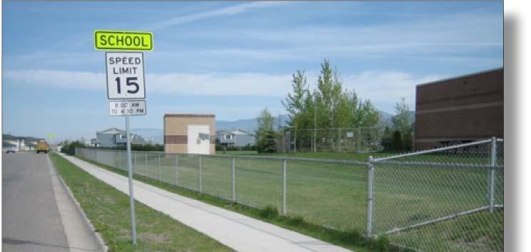
30 Bozeman Safe Routes to School Assessment Existing Conditions Emily Dickinson School Emily Dickinson School is the northernmost elementary school in Bozeman and is currently the largest in the system serving approximately 500 students grades K through 5. Major Streets nearby include Durston Road, Oak Street, and North 19 th Avenue. Emily Dickinson School is located in one of the newest areas of Bozeman with new residential development around the school and continuing to develop to the west and north. At the time of writing, Emily Dickinson School has received the most attention of the Bozeman Elementary Schools with respect to Safe Routes to Schools. The 2007 International Walk to School Day was very successful, with lasting effort being made with some parents continuing to lead walking school buses. Emily Dickinson School was awarded a State Safe Routes to School grant in 2007 for educational and promotional materials, and the purchase of mobile radar speed signs. Immediate vicinity of Emily Dickinson School Information for this section was collected at the community workshop on November 1 st, 2007, and at the walking audit where the morning commute was observed on November 5 th. The results are summarized below. For the notes from the walking audit please see Appendix B Walking Audit Summary. The existing conditions surrounding Emily Dickinson School including crosswalk locations, and existing sidewalks can be found graphically in Appendix A Parent Map. Parent Drop-offs / Pickups Traffic cones form a new curb line to narrow the drop-off area at Emily Dickinson School 26 A vast majority of students at Emily Dickinson School appeared to be dropped off by private vehicles. During the hour of observation a steady flow of vehicle drop offs occurred with a much higher concentration for the 10 minutes prior to school start. The main vehicular access to Emily Dickinson School is on Annie Street. There is an entrance and an exit driveway that parents use as a loop to load students. This area is very wide and there is a fire lane that has to be kept clear directly in front of the main doors to the school. School staff have devised a system of using traffic cones to narrow the area because too many parents were double and triple parking in this space while having students weave between vehicles on foot. Parents are advised to pull forward to the school entrance to load students, however this is frequently ignored. Vehicles not pulling to the front cause backups that extend out onto Annie Street. These occurrences reduced pedestrian safety at the entrance to


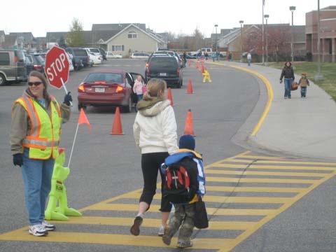
31 Emily Dickinson School the school at the crosswalk and also blocked buses from accessing the bus loading area. Parking stalls in front of the school are also partially blocked off with the cones to discourage use during school commute times. Vehicles were also observed unloading students along North 25 th Avenue and along Annie Street adjacent to the school. Students were observed emerging from vehicles traveling eastbound on Annie Street and crossing the street rather than walking to a crosswalk. The Bozeman Police Department occasionally patrols the school zone during school commute times. School officials have noticed better behavior by parent drivers when the Police are present. During the walking audit concerns were made regarding distracted drivers due to cell phone use and or eating/drinking while driving. Emily Dickinson School is one of the few schools that has adequate staff parking. The parking area is on the east side of the school near the bus loading area. Bus Arrivals / Departures Students arriving by bus are separated from parent drop-offs via a separate area of the school grounds containing a bus turnaround and loading area to the east of the main building. Many busses were observed arriving between 7:45 and 8:35am. The crossing guard present at the entrance to the school on Annie Street facilitated bus entry by moving a Sidewalk Sammy out of the way. The bus loading area drops students off at the side entrance to the school and near the playground where they remain until school begins. The only observed problem with bus arrivals was during congested periods where the entrance to the school can be completely obstructed by parents dropping children off. The bus loading area works well, however parent vehicles can block the entrance to this area at times. Pedestrian & Bicycle Arrivals / Departures As compared to other Bozeman schools, Emily Dickinson School currently appears to have moderate rates of walking and bicycling. Some parents were observed arriving on foot with students. Students were observed to be arriving from the west across North 25 th Avenue, from the east along Annie Street, or from the north or south along North 25 th Avenue. Crossing guards currently are present at three locations including South 25 th Avenue and Durston Road, North 25 th Avenue and Annie Street, and the vehicular entrance to the A crossing guard walks a group of students from one crossing (Annie St) to one across the school parking lot 27


32 Bozeman Safe Routes to School Assessment school on Annie Street. Where crossing guards were present, children were observed waiting for permission to cross the street, with the exception of Annie Street where some students walked across the street after they were dropped off. Emily Dickinson is situated in some of Bozeman s newer areas and has no issues with substandard curb ramps. Emily Dickinson School has bicycle parking located near the northeast corner of the school on a paved concrete pad that can accommodate up to 30 bicycles. School staff report that the bike racks are often full. During the walking audit there were 16 bicycles parked in the racks even with the temperature recording a chilly 25 degrees. Durston Road and Oak Street both have bicycle lanes and there are some trails, both paved and natural surface nearby the school that could play a role in routes that are chosen as bicycle routes. Street conditions Annie Street in front of Emily Dickinson School North 27 th Avenue is wide with little parking. High speeds have been observed. Annie Street serves as the main access point to Emily Dickinson School. At the time of the walking audit there were No Parking signs to the east of the school along Annie Street, but vehicles routinely unload students in these areas. These signs were requested by a previous principal, however this restriction is now being viewed negatively because safe student unloading could be accommodated in these areas relieving congestion at the main entrance to the school. There are crosswalks across Annie Street at the east side of the eastern driveway to the school and at the intersections of Annie Street and North 25 th Avenue. Annie Street currently does not have a sidewalk on the south side of the street across from the school. These will be installed when the residential lots are developed in the future. North 25 th Avenue is classified as a local street and carries the majority of school traffic to Emily Dickinson School. This road is also a primary pedestrian corridor and has important crossings at Annie Street and at Durston Road. Parents and school staff expressed concern about high vehicle speeds on this roadway, considerably higher than the 15mph speed limit in the school zone that stretches from Lily Drive to Dawes Drive. There are no stop signs from Oak Street to Durston Road along North 25 th Avenue. Walking audit participants also noted drainage problems at the intersection with Annie Street. Water flows to the north along the street gutters and can cause flooded pools at the curb ramps and crosswalks. This problem is exacerbated in the winter where large ice dams can form making this crossing more difficult. 28


33 Emily Dickinson School North 27 th Avenue is also an important street near Emily Dickinson School and is classified as a collector street. This roadway has a single crosswalk striped across it at Annie Street that is an important east-west connection for students living in the neighborhoods to the west. North 27 th Avenue is 40 feet wide. There is little use of the parking areas creating effective lane widths of 20 feet or 13 feet if parking is present. Lane widths greater than 11 feet can contribute to higher vehicle speeds. Additionally there is no pavement striping reinforcing the wide feel to the roadway. North 27 th Avenue also connects Durston Road to Oak Street and points further north. As the area to the north develops it is likely traffic on North 27 th Avenue will increase. Durston Road is a 3-lane minor arterial that was improved in During reconstruction a pedestrian refuge island was added at the intersection with North 25 th Avenue at the request of the school principal. This feature increases the visibility of the crossing and provides pedestrians with a safe place to stop, allowing them to cross one direction of traffic at a time. There is a crossing guard at this location that helps students cross this roadway during school commute times. The current school attendance boundary for Emily Dickinson includes several residential streets to the south of Durston Road, making the new pedestrian refuge island important. This refuge island was added to the North 25 th Ave crossing of Durston Road in 2007 Oak Street is a 4-lane principal arterial with large wide medians. The roadway has bike lanes and sidewalks but its very wide cross-section makes crossings difficult as pedestrians must cross as much as 96 feet of roadway in some locations (which at a child s typical walking speed of 4 ft/sec, means an average of 24 seconds to cross). A vehicle traveling 45mph can cover nearly 1,600 feet or 0.3 miles in that time. The medians along Oak Street were designed pulled back from the pedestrian crossings and allow vehicles to turn at high speeds. These medians are a missed opportunity and could act as refuge islands for pedestrians. Sidewalks in the vicinity of Emily Dickinson School are mostly new with ADA accessible curb ramps at intersections. There are still some gaps in the sidewalk network near the school as completion of sidewalks fronting residential lots are the responsibility of the builder of that lot. As these lots continue to develop these gaps will close. There are also some strange sidewalk gaps at trail crossings leaving a large elevation differential to be crossed by the pedestrian (Stoneridge Drive). Snow removal on sidewalks near Emily This pedestrian crossing at the intersection of Oak Street and North 27 th Avenue is almost 100 feet across 29


34 Bozeman Safe Routes to School Assessment Dickinson School can also be a challenge to walking in the winter, as not all property owners reliably clear snow from sidewalks. Trails This trail crossing on Windsor Street is one of several locations that have sidewalk gaps Emily Dickinson School has several trails in the vicinity that can offer alternative routes to school. There are four north-south trail corridors and three east-west connections. Several sections of trail and connecting sidewalks are missing or have been so poorly maintained that the trail has been overgrown and impossible to use such as the trail corridor directly adjacent to Emily Dickinson School on the east side connecting Annie Street to Oak Street. There are also several places where drainages require small footbridges to make additional connections. Some of these routes are within private parks and will require participation and agreement with the Homeowners Associations to make the needed improvements. Some of the improvements may be items that should have been included when initial construction took place. Attendance Boundary The school attendance boundary for Emily Dickinson School established by the School Board on March 3rd, 2008 includes an area bounded by North 19 th Avenue to the east, Cattail Street to the north and Durston Road to the south. Some streets just to the south of Durston Road were included in the school boundary as well. The attendance boundary stretches out to the west and will encompass many new developments over the coming years. The analysis contained within this plan focuses only on the boundary close to Emily Dickinson School and the challenges facing students within this area. Please see page 2 for a map of the school attendance boundaries. Multiple paved and natural surface trails provide neighborhood connections to and near Emily Dickinson School 30

35 Emily Dickinson School Next Steps This section of the Emily Dickinson School Improvement Plan outlines a series of next steps for each of the Five E s in the form of recommended programs, policies and capital projects. To assist in planning for the implementation of these projects, additional information is provided on each item including the groups that should be involved from the How to Use This Document section on page 1, and an approximate cost range for the project. Generally, costs for each next step will be categorized as follows: $ = Minimal to $500 Volunteer effort and low funding required $$ = $500 to $2,500 Low amounts of funding required $$$ = $2,500 to $10,000 Moderate amounts of funding required $$$$ = $10,000 to $50,000 High amounts of funding required $$$$$ = $50,000+ Very high amounts of funding required It should be noted that these next steps are a series of recommendations as part of a Safe Routes to School program. Not all of these projects and programs need be implemented to improve the environment for walking and biking to school for students. The recommended projects listed in the following pages should be reviewed as part of the overall strategy for Emily Dickinson School. Some projects will require more time, support, and funding than others. It is important to achieve shorter-term successes while laying the groundwork for progress toward some of the larger and more complex projects. The next steps presented here are meant to be flexible in implementation and the decision to undertake a project or program should be made based on the available resources of the school team, and when applicable, the City of Bozeman. 31


36 Bozeman Safe Routes to School Assessment Engineering Next Steps Curb extensions are becoming commonplace in Bozeman as a traffic calming solution Cost $$$-$$$$ Groups City of Bozeman, Safe Routes to School Taskforce, School Administration Description North 25 th Avenue could benefit from additional improvements to further emphasize its importance as a school zone. The intersection of North 25 th Avenue and Annie Street is the main access point to Emily Dickinson School and should have special treatments to reduce speeds and increase pedestrian safety. Curb extensions at the existing crosswalk across the northern leg of this intersection would provide a visual pinch point at this location signaling motorists to take greater care and hold the 15mph speed limit. Curb extensions at this location would also put pedestrians in a position where they could see approaching vehicles better and would also reduce the crossing distance and exposure to traffic. A major design consideration of this project is the drainage on North 25 th Avenue. Currently the drainage is a problem and can leave pedestrians with water or frozen ice to negotiate while crossing the roadway. Curb extensions can be constructed with channels following the existing curb line allowing for drainage. In this case the curb extension would allow the pedestrian to cross over the gutter without having to step through the water or ice. Looking north from the pedestrian bridge, little is left of the natural surface trail that was installed years ago. Cost $$$ Groups City of Bozeman, Safe Routes to School Taskforce, School Administration Description A natural surface trail was implemented to pass through a private park paralleling Woodland Drive from Annie Street to Oak Street, passing directly adjacent to Emily Dickinson School. This trail has become overgrown and disused and it is hard to ascertain its actual location. This trail should be rebuilt to a higher standard that will require little maintenance. One possibility is to continue the sidewalk along the eastern side of the bus turnaround to the east-west neighborhood connection. The trail could be continued north from this location. Access to this trail should also be provided at the end of the cul-de-sacs of Daws Drive and Wheeler Drive. 32


37 Emily Dickinson School Cost $$$$-$$$$$ Groups City of Bozeman, Safe Routes to School Taskforce, School Administration Description There are several places in the vicinity of Emily Dickinson School that have missed opportunities with regard to trail connections. With the large number of trails and paved walkways in the area it would be advantageous to maximize the extent of the network. Below is a list of missing links that would help connect the neighborhoods better and provide additional options for students walking or bicycling to school. East end of east-west paved trail that connects directly to Emily Dickinson School via bridge: Continuation of the walkway and a small bridge are needed to reach existing natural surface trail running north-south. Approximately 40 feet of new concrete path are needed and a bridge. East end of east-west paved trail that begins at the Rose Street cul-de-sac: This paved walkway also requires a short extension and bridge crossing over a small stream to reach an existing north-south paved trail which terminates at a crosswalk with a crossing guard at the entrance to Emily Dickinson School. North-south paved trail connecting Durston Road to Annie Street: This paved walkway passes by a large multi-family housing complex to the east and comes within several feet of four to six possible sidewalk connections. These connections should be made to encourage use of this walkway by the adjacent residents. This gap in the paved trail would connect Emily Dickinson directly with natural surface across this creek 33
38 Bozeman Safe Routes to School Assessment Sidewalk gap at trail connection at Windsor Street Cost Groups Description $-$$$ depending on responsible party City of Bozeman, Safe Routes to School Taskforce, School Administration There are several segments of sidewalk near Emily Dickinson School that are missing and are in need of construction. Currently, all sidewalk and vegetation maintenance in the City of Bozeman for sidewalks fronting residences is the responsibility of the homeowner. However, the City seeks to provide some level of maintenance support. This is largely due to few contractors willing to take on small concrete jobs, so residents are often unable to find a professional to undertake patching. At present, the City does not bill the costs of sidewalk patching or vegetation removal back to the homeowner. For vegetation maintenance, the City Forrester will perform maintenance as staffing permits and/or send letter to homeowner explaining their responsibility5. A list of locations where sidewalk construction is needed can be found below in Table 6 Sidewalk Construction Needs. It is recommended that the City first attempt contacting the responsible party (homeowners associations, developers, or builders) requesting that the construction be performed. If the construction is not performed, the City should then work with the responsible party and perform the work using City resources. There are many missing segments near Emily Dickinson School, but most are vacant lots that have yet to be developed. It is currently the responsibility of the builder to finish these sidewalks when the lot is built on. Missing sidewalks on vacant lots are not listed in Table 6 Sidewalk Construction Needs. Table 6 Sidewalk Construction Needs Windsor Street at n/s trail crossing both sides Maplewood Street north side on the east end of the street Emily Dickinson School east side of staff parking area 60 feet total There are gaps in the sidewalk on both sides of the street within a private linear park. Priority = Medium 160 feet Part of this gap is the private linear park, part of it is a vacant commercial parcel. Priority = Medium 280 feet This gap allows a paved connection between existing sidewalk segments. It could serve as a portion of the deteriorated trail connection paralleling the creek noted in ENG-2. Priority = Medium 5 Source: John Van Delinder, Street Superintendent 34


39 Emily Dickinson School Cost Groups Description $-$$$$$ Depending on location City of Bozeman, Safe Routes to School Taskforce, School Administration The main pedestrian access routes to Emily Dickinson School include Annie Street and North 25 th Avenue. Other significant streets include North 27 th Avenue, Durston Road and North Hunters Way. Pedestrian crossings provide visibility, access opportunities, and traffic control along preferred walking routes and across busy streets. The locations requiring investment are listed below in Table 7 - Roadway Crossing Needs Annie Street and North Hunters Way Annie Street and Buckrake Avenue Annie Street and North 25 th Avenue Oak Street and North 25 th Avenue (east side) Table 7 Roadway Crossing Needs Striping and signage $ A crossing should be striped and signed across the northern side of this intersection along Annie Street as an encouraged route to Emily Dickinson School. This location is one of only two along this street that lack crosswalks. Priority = Medium Striping only $ A crossing should be striped and signed across the northern side of this intersection along Annie Street as an encouraged route to Emily Dickinson School. This location is one of only two along this street that lack crosswalks. Priority = Medium Curb Extensions $$$ See ENG-1 Priority = High Striping, Signage, Flashing beacon with reduced speed zone signs $$-$$$ The area to the north of Oak Street is growing rapidly and will have many residences within the school attendance boundary of Emily Dickinson School. There are existing marked crossings at North 27 th Avenue and North Hunters Way, but they cross wide sections of the roadway making them less suitable for student use. A new crossing is proposed at the east side of North 25 th Avenue complete with appropriate school zone signage, and reduced speed signs with flashing beacons in advance of the crossing. When this crossing is constructed a new crossing guard should be assigned to it during commute periods. Priority = High Striped crossings such as this one help emphasize recommended routes to school and add visibility for pedestrians at crossings This crossing at Oak Street and North 27 th Avenue is very long to cross. A new crossing at North 25 th Avenue should be used by Emily Dickinson School Students. 35


40 Bozeman Safe Routes to School Assessment Enforcement Next Steps Radar Equipped Speed Signs can lower speeds near the school Cost $$$ Groups City of Bozeman, Safe Routes to School Taskforce Description As discussed in this plan, North 25th Avenue has perceived speeding and traffic volume issues. Radar Equipped Speed Signs with bright LED displays placed on North 25th Avenue could have a dramatic effect on informing motorists they are entering a school zone where children may be present. Speed Signs are available from a number of manufacturers and can be battery or solar powered in addition to standard hard wiring. Typically, these units cost approximately $3,000-$5,000 each. Two signs are recommended for Emily Dickinson School, placed just before Goldenrod Lane southbound and one at Daisy Drive northbound, north of the fourway stop sign. Existing mobile versions of the signs can be used to gage effectiveness. Cost $ Groups PACs, School Administration Description Sometimes a simple reminder can have tremendous effect on bad behavior. Distracted drivers were noted as problems during the walking audits at all schools in the Bozeman Safe Routes to School Assessment. Noted problems included cell phone/electronic device use and eating while negotiating the crowded dropoff/pickup areas. An example of removable behavior signs include a project in Bozeman at Longfellow School where a portable homemade speed limit sign is placed in the middle of South Tracy Avenue by volunteers during school commute hours. Cell phone use is prohibited and enforced by school staff at this school Cost Groups Description Unknown PACs, School Administration A Crossing guard will be needed at N 25 th Ave. and Oak St will be needed to help deal with increased student traffic from the new attendance boundary to the north at crossing. 36
. Sidewalk Sammys are typically placed in visible locations at crosswalks, street medians, and congested areas to be highly visible reminders that children are present.")
, Safe Routes to School Taskforce Description At each of the walking audits participants noticed an instant improvement in driver behavior if a")


41 Emily Dickinson School Cost $ - Approximately $35 each. Groups PACs, School Administration Description Bozeman elementary schools have made good use of previously donated Sidewalk Sammys ( Sidewalk Sammys are typically placed in visible locations at crosswalks, street medians, and congested areas to be highly visible reminders that children are present. If Emily Dickinson School feels that additional Sammys would be helpful it should seek their purchase or donation. Cost $-$$$$ Groups City of Bozeman (Police Department), Safe Routes to School Taskforce Description At each of the walking audits participants noticed an instant improvement in driver behavior if a police vehicle was nearby. When asked, crossing guards and school administrators verify the observed benefit of police presence and would like to see patrol vehicles near their schools more often. The Bozeman Police Department currently has beats assigned to individual officers. It is the policy of the Police Department that if the officer is not responding to calls during school commute hours then the officer patrol the school zones within his/her beat. Recent staffing and funding improvements brought about through the Public Safety Mill Levy should increase the ability of the police department to patrol school zones with 2-3 officers per 1-3 schools within a beat versus 4-5 officers attempting to cover all the schools in the past. It is recommended that the effectiveness of this policy be reviewed by the Safe Routes to School Taskforce and the Bozeman Police Department. If staff shortages or funding problems prevent increased enforcement in the future then funding sources to pay for additional officer time should be sought. The Montana State Highway Traffic Safety Bureau has a program that may help. This program is currently used by the police department for enforcement of unsafe or impaired driving. Typically hours per month are funded. Sidewalk Sammys add inexpensive and portable visibility to school commutes Police presence can have dramatic effects on driver behavior 37

42 Bozeman Safe Routes to School Assessment Education Next Steps This class is receiving pedestrian safety training Cost $$-$$$ Groups City of Bozeman, Safe Routes to School Taskforce Description The City of Bozeman should lead an effort to create a pedestrian safety curriculum, including lesson plans, materials, and evaluation tools. While there are many ways to do this, one recommended model uses the following strategies: Target second grade students and provide training annually Teach one module in fall and one in spring Cover the same material in a variety of ways to accommodate different learning styles (e.g. movement, writing, songs) Follow classroom learning by physical practice (e.g. on simulated street, grading adults modeled behavior, and/or group crossing drills) Cost $$-$$$ Groups City of Bozeman, Safe Routes to School Taskforce, School Administration Description The Pedestrian Safety Training curriculum (see above) should be offered at Emily Dickinson as a pilot program to all second grade classrooms in Fall Based on feedback received from the pilot, the curriculum may be modified for future instruction. There are many possible approaches to hiring and training staff; this decision should be made in conversation with the City, the School District, the Safe Routes to School Taskforce, and interested community volunteers (such as the Bozeman Area Bicycle Advisory Board). A trainer may be City staff, a School District employee (such as an interested PE teacher), or a community group member. The trainer can be hired or be a volunteer. 38
, as well as the School District, to develop a standard safety handbook that is provided to parents at the beginning of the school")
43 Emily Dickinson School Cost $$-$$$ Groups City of Bozeman, Safe Routes to School Taskforce, School Administration Description The City should work with local bicycle advocacy groups (Gallatin Valley Bicycle Club, Bozeman Area Bicycle Advisory Board, GAS Cycling Team), as well as the School District, to develop a standard safety handbook that is provided to parents at the beginning of the school year. The handbook should include school specific information regarding: A school area pick-up/drop-off circulation map of the campus and immediate environs, preferred pick-up, drop-off and parking patterns and text explaining the reason behind the recommendations. Map showing recommended walking and biking routes, including bike parking locations on campus Basic rules of the road (brief, using images as much as possible) List of the most dangerous driving behaviors (and how parents can help) School traffic safety contact names and numbers Explanation of the Safe Routes to School program (goals, strategies, and benefits) Volunteer opportunities for Safe Routes to School program (e.g. crossing guards, leaders for walking school bus and bike trains) Calendar of Safe Routes to School events for the school year Maps like this one (see Appendix A) should be a part of the School Traffic Safety Handbook 39

44 Bozeman Safe Routes to School Assessment Riding practice in small groups can greatly improve riding behavior amongst students Cost $$-$$$ Groups City of Bozeman, Safe Routes to School Taskforce, School Administration Description The City of Bozeman should lead an effort to create a bicycle safety curriculum, including lesson plans, materials, and evaluation tools. While there are many ways to do this, one recommended model uses the following strategies: 1. Target fifth grade students and provide training annually. 2. Cover the same material in a variety of ways to accommodate different learning styles (e.g. movement, writing, songs). 3. Provide 10 contact hours, including in-class time, playground drills, and community rides around the school with instructors and community volunteers. The bicycle safety curriculum should cover: Parts of the bicycle Flat fixing Bicycle safety check and basic maintenance (chain lubrication, tire inflation, brake check) Helmet fitting Rules of the road Riding practices (where to ride) Hand signals Bicycle handling and skills drills Avoiding hazards Intersection practice Turning techniques Braking drills Community rides allow children to apply the skills they learned in the classroom and during playground drills. Trained volunteers and instructors should give children feedback and reinforce key lessons. Sample curriculum available at: 40

45 Emily Dickinson School Emily Dickinson School Improvement Map 41

46 Bozeman Safe Routes to School Assessment Encouragement Next Steps Cost $ Groups Safe Routes to School Taskforce and School Administration Description Every Emily Dickinson school newsletter should include a Safe Routes article or feature. Possible features include: The circulation map (from next step Edu-3) Upcoming Safe Routes to School events Facts about walking, biking, physical activity, traffic safety, etc. Reporting on contest winners International Walk to School Day 2007 Emily Dickinson School, Bozeman Cost $-$$ Groups Safe Routes to School Taskforce, School Administration, and City of Bozeman Description International Walk to School Day is held annually on the first Wednesday in October. This event can serve as a kick-off event to generate awareness and enthusiasm for a Safe Routes to School program. Events may include a special Walking School Bus lead by local politicians or school administrators, school assembly, and contest. Schools may find additional information and register for the event at Events such as these tend to attract increased attention and excitement that can be tapped to attract volunteers to maintain efforts year-round. 42

47 Emily Dickinson School Cost $-$$ Groups Safe Routes to School Taskforce, School Administration Description Find at least one classroom willing to track their mileage towards a specific goal. The goal can be customized for the teacher s interest and curriculum; examples would be accumulating enough miles to cross America, cross Montana, complete a marathon, or travel some other distance related to classroom curriculum (e.g. geography, history or mapping unit). The results should be talked about by the school (such as in the newsletter or at a school assembly). If more than one classroom chooses to participate, it could be set up as a race or contest, with a prize or trophy (e.g. The Golden Sneaker) going to the winning classroom. Wall maps show the progress of the contest Cost $ Groups Safe Routes to School Taskforce, School Administration, PACs Description A Walking School Bus involves parents taking turns walking (or bicycling in a Bike Train ) with groups of students to school from a designated meeting area. Interest should be explored by School administration and availability of parent volunteers to lead a regular Walking School Bus. 43
48 Bozeman Safe Routes to School Assessment Funding While much of the initial work involved in starting a Safe Routes to School program can be conducted by volunteers, funding is needed to plan and implement physical improvements, hold events, and develop and implement educational programs and materials. To maximize the number and variety of programs and projects, funding should be pursued from a variety of sources. Program Funding As Bozeman s Safe Routes to School program develops, funding is needed to support the overall program. Funding is needed for a paid staff coordinator, purchasing incentives, printing newsletters, event staffing, and developing educational materials. Both individual school-based and program-based funding will be essential for success. When program funding is pursued, it should be emphasized that a Safe Routes to School Program improves the entire community by relieving traffic congestion, contributing to cleaner air, creating alternative transportation routes, and improving the health and safety of children and the entire community. Possible funding sources include: Corporations and Businesses. Local corporations and businesses may be able to provide cash, prizes, and/or donations, such as printing services, through community giving or other donation programs. Parents or other members of stakeholder teams may be a good personal source for contacting companies. Foundations. There are institutions throughout the country that provide funding to non-profit organizations. The Foundation Center is a national organization dedicated to collecting and communicating information about philanthropy in the U.S., and is an excellent source for researching potential foundation funding sources. Potential foundation funding sources can be searched by geographic region and by category. Some categories that may be applicable include transportation, health, environment, and community building. Status as a 501c(3) non-profit is required for funding. Local and state foundations include: 44
49 Emily Dickinson School o Bozeman Area Community Foundation o Montana Community Foundation o Bozeman Schools Foundation o Mountain Sky Guest Ranch Individuals. Statistically, individuals give more money than corporations and foundations combined. A local fund drive can quickly reach a large number of people if outreach is conducted by stakeholder team members. Events. Many SR2S programs have raised funds by holding special events, often using a related themed event such as a walkathon or a bicycling event. More traditional fundraising efforts, such as car washes, concerts, talent shows, etc., can also help raise funds. Parent Advisory Committees (PACs) and School Districts. Many PACs have funds to distribute to school programs, and often schools have their own safety funding sources. Stakeholder teams should work with local PACs and school districts to see if there is a method for applying for a grant. City and County Funds. Some cities and counties allocate funds to support Safe Routes to School programs. Some also allocate a portion of their local Transportation Enhancement or general funds to Safe Routes to School educational programs. State Funds. The Montana Department of Transportation administers the Federal Safe Routes to School Program as part of the Federal Transportation funding program (SAFETEA-LU). A portion of the one million dollar annual budget is available to education and encouragement programs. 45

50 Bozeman Safe Routes to School Assessment Capital Funding MDT s Safe Routes to School Program can help! Capital funding for infrastructure improvements is available from a variety of sources. Usually, public agencies must initiate changes in the public right-of-way, and must be involved from the beginning of any project discussion. The Safe Routes to School Taskforce should work with the City of Bozeman to ensure that all potential funding sources are pursued and to help prioritize projects for funding and implementation. The capital projects proposed in this plan should ideally be added to the City s Capital Improvement Plan (CIP). If no direct City money can be leveraged to implement some of the projects, there exists the opportunity for the City to require implementation from developers as traffic mitigation for new projects if they increase traffic near schools. Capital funding sources are summarized below and in Table 8 Summary of Capital Funding Sources. Bozeman Safe Routes to School projects can pursue Federal Safe Routes to School funds, which are administered by the Montana Department of Transportation and are available annually through the Montana Safe Routes to School Program, a competitive grant process with applications due each December. Safe Routes to School funds are a federally funded reimbursement program, but require no local matching funds. The Transportation Enhancements portion of the Federal Transportation funding program (SAFETEA-LU) are also available. In Montana these funds are distributed as part of the Community Transportation Enhancement Program (CTEP). CTEP has 12 eligible categories. The most frequently applied for categories include bicycle and pedestrian facilities. The CTEP program provides an average of $2.7 million a year for bicycle and pedestrian facilities in Montana. The CTEP program is not a grant program, but a federally funded reimbursement program and requires a percent local match. Federal transportation funds are available as State Highways System Funding on designated state highways in Montana maintained by the Montana Department of Transportation. Activities eligible for funding typically include construction, reconstruction, resurfacing, restoration, rehabilitation and operational improvements. Projects may include components that provide or enhance pedestrian and bicycle 46
51 Emily Dickinson School facilities. It is recommended that the Safe Routes to School Taskforce inquire as to the status of projects that are planned near schools and review the level of planned accommodation for pedestrians and bicyclists. The purpose of the Surface Transportation Program Hazard Elimination (STPHS) is to identify hazardous locations throughout the state s highway system and schedule projects for improvements. Projects are funded with a 90/10 Federal and State split. MDT s Traffic and Safety Bureau selects the projects by identifying hazard sites through the analysis of accident reports. The Montana State Highway Traffic Safety Bureau administers federal grant monies for safety programs aimed at reducing deaths, injuries, and property losses resulting from traffic crashes. Some of these grants cover administration costs such as increased overtime patrols for law enforcement agencies and the cost to purchase new law enforcement equipment. Others cover the production and delivery of educational programs. The Bozeman Area Bicycle Advisory Board (BABAB) Oversees a $50,000 annual budget for improvements to the City s bicycle infrastructure. Projects need to be discussed, recommended by the board to the City Engineer and approved before they can be implemented. The Board meets the first Tuesday of the month at 6:00 pm at 20 E. Olive Street. Enter though the southside doors, first floor, conference room #1. 47
52 Bozeman Safe Routes to School Assessment Table 8 Summary of Capital Funding Sources Montana Department of Transportation Safe Routes to School Program Community Transportation Enhancement Program (CTEP). State Highways System Funding Surface Transportation Program Hazard Elimination Montana State Highway Traffic Safety Bureau Bozeman Area Bicycle Advisory Board (BABAB) Distributes federal Safe Routes to School money within Montana, $1,000,000 annually. No local match required. MDT administers funding for Safe Routes to School programs in Montana. Good to piggyback pedestrian and bicycle projects on larger roadway projects, percent state match Cost/benefit ratio controlled program. 10 percent state match. Safety programs aimed at reducing deaths, injuries, and property losses resulting from traffic crashes. May only be eligible where accidents have occurred. The BABAB has no formal grant process, however mid-range capital projects can be considered for funding at the monthly meeting. See website for additional details. No website No website
53 Emily Dickinson School Resources The National Center for Safe Routes to School Montana Department of Transportation Safe Routes to School Program National Center for Bicycling and Walking National Highway Traffic Safety Administration Safe Routes to School National Partnership Kidswalk Provides numerous resources, including benefits of SR2S, training, and a guidebook for establishing a SR2S program. MDT administers funding for Safe Routes to School programs in Montana. Provides Safe Route to School Workshops for communities interested in establishing a SR2S program. NHTSA hosts a Safe Routes to School website that includes an overview of establishing and implementing a SR2S program, sample promotional materials forms and surveys, safe streets toolkit and engineering enhancements, classroom activities, and links to resources. A network of more than 300 nonprofit organizations, government agencies, schools, and professionals working together to advance the Safe Routes to School (SRTS) movement in the United States. This Center for Disease Control website provides resource materials, health benefits of walking, pedestrian safety information Routes-2002/toc.html Routes-2004/index.html
54 W OAK ST W OAK ST NEW HOLLAND DR JOHN DEER ST CATERPILLAR ST HARMON WAY SPRINGBROOK AVE N HUNTERS WAY BUCKRAKE AVE BARLEY AVE GOLDENROD LN DAISY DR WHEELER DR DAWS DR Emily Dickinson School WOODLAND DR MAPLEWOOD ST BRENTWOOD AVE STONERIDGE DR N 19TH AVE ANNIE ST LILY DR ASTER AVE LILY DR ROSE ST SNAPDRAGON ST OLIVER ST DAFFODIL ST DURSTON RD DURSTON RD VALLEY DR ft N HUNTERS WAY GREENWAY AVE WESTERN DR N 25TH AVE N 23RD AVE N 22ND AVE N 21ST AVE N 20TH AVE N 19TH AVE Appendix A - Parent Map - Emily Dickinson School Recommended Route Discouraged Route Marked Crosswalks Missing Sidewalk Difficult Intersection Unpaved Trail Paved Trail Crossing Guard Park Traffic Signal 10 min walk 20 min walk
55 Emily Dickinson School Appendix B Walking Audit Summary A walking audit of Emily Dickinson School was conducted at 7:30 on Monday, November 5, Participants observed student arrivals by bus, car, walking and bicycling. Walking Audit attendees: Jody Sanford City of Bozeman Mark Williams Roy Crosby, Assistant Principal Joe Gilpin & Jessica Roberts, Alta Planning Emily Dickinson School is the northernmost elementary school in Bozeman and serves approximately 500 students. The sidewalk network is well developed in and around the school. Several small gaps do still exist and are being closed as vacant lots are developed. As the neighborhood is relatively new, there are ADA compliant curb ramps on nearly all midblock and intersection crossings. Two north-south trails help connect the school with surrounding homes. The first parallels Hunters Way and crosses Durston Rd to the South. The second connects Oak St. to Durston Rd just east of the school and connects directly to the school via a footpath and bridge. Oak St and Durston Rd do have bike lanes however due to their arterial status and high travel speeds there is doubt as to their permeability to walking and bicycling by primary school students, potentially reducing the catchment area by such trips. Two permanent rows of bicycle racks exist, each accommodating up to 30 bicycles near the main entrance to the school. Vehicle Arrivals A vast majority of students at Emily Dickinson School appeared to be dropped off by private vehicles. During the hour of observation a steady flow of vehicle drop offs occurred with a much higher concentration for the 10 minutes prior to school start. Emily Dickinson School has made changes to the drop-off procedures for the school year by placing traffic cones daily to the outside of the fire lane in front of the main entrance to the school. These cones guide parents to drop off farther in the middle of the lot. This dissuades drivers from double parking, or overtaking other vehicles that can create an unsafe situation. 51
56 Bozeman Safe Routes to School Assessment Currently drivers are encouraged to pull forward to the school entrance to unload children, however this is not always followed. This new system had its problems initially however parents have now had time to adjust and the configuration is functioning better. Occasionally vehicles were observed unloading near the entrance to the parking lot causing a back-up in traffic that could extend out to Annie St. These occurrences affected pedestrian safety at the entrance and bus arrivals. Vehicles also unloaded children along N. 25th Ave and along Annie St. adjacent to the school. Notes/Issues: Children from vehicles dropping off eastbound on Annie St. frequently run across the road rather than walking to a designated crossing Safe crossings (crossing guard, or marked crossings) do not always exist from popular drop-off areas, see above. Not all drivers entering school property pulled forward to the drop-off area causing backups onto Annie St. and unnecessary congestion. Bus Arrivals Students arriving by bus are separated from parent drop-offs via a separate area containing a bus turnaround and parking area to the east of the main building. Many busses were observed arriving between 7:45 and 8:35am. The crossing guard present at the entrance to the school on Annie St. facilitated bus entry by moving a Sidewalk Sammy. Problems with bus arrivals appear to be limited to congested periods where the entrance to the school is completely obstructed by parents dropping children off. 52
57 Emily Dickinson School Pedestrian/Bike Arrivals Students arriving by foot were frequently accompanied by an adult, however many traveled alone or with a friend/sibling. Students typically arrived from four directions. Annie St. from the West, Annie St from the E 25th Ave. from the North, and N 25th Ave. from the South (from Durston Crossing). Crossing Guards were present at the Annie St. entrance to the school, the intersection of Annie St. and N 25th Ave. and the intersection of N 25th Ave. and Durston Rd. Where crossing guards were present, children were observed waiting for permission to cross the street. Notes/Issues: High vehicle speeds present on N 25th, N 27th and Annie St. Speeds are higher on Durston Rd and Oak St. 4-way stop sign at Annie St. and N 25th Ave is not adequately observed by all drivers. Drainage along N 25th Ave. is poor and during periods of wet or wintry weather causes flooding of the curb ramps and hazardous ice dams. Lack of sidewalks along south side of Annie St by school grounds. This area is slated for a residential development and will be constructed as the lots are completed. Lack of sidewalk connection from the north side of Annie St to existing crosswalk though school parking lot towards main entrance of school. Trail/sidewalk connection from N/S trail 53
58 Bozeman Safe Routes to School Assessment Appendix C Glossary MUTCD (Manual of Uniform Traffic Control Devices) This document sets forth principles and standards for controlling traffic in school areas. These principles and standards provide information on appropriate design, application and maintenance of all traffic control devices (including signs, signals and markings). Walking School Bus - A walking school consists of groups of students accompanied by adults that walk a pre-planned route to school. Routes can originate from a particular neighborhood or, in order to include children who live too far to walk, begin from a designated meeting place. They may operate daily, weekly or monthly. Often, they are started in order to address parents concerns about traffic and personal safety while providing a chance for parents and children to socialize. Bike Train A bicycle train consists of groups of students accompanied by adults that bicycle a pre-planned route to school. Routes can originate from a particular neighborhood or, in order to include children who live too far to walk or bicycle, begin from a designated meeting place. They may operate daily, weekly or monthly. Often, they are started in order to address parents concerns about traffic and personal safety while providing a chance for parents and children to socialize. School Zone The school zone begins at the front door of the school and encompasses the campus and as many blocks as possible that surrounds the school and has a high concentration of school-generated traffic. Often the school zone includes the streets along the school and usually the area one to two blocks around it. The school zone should be marked with special signing to alert drivers of the high concentration of children. School crossing signs, speed signs, school zone pavement markings and other traffic calming devices remind drivers to treat the area with special care and attention. 54

 is optional where the approach is controlled by a signal, stop sign, or yield sign. 2.")
59 Optional in advance of Installation C S4-1 R2-1 Installation C 6" solid white stripe SPEED LIMIT 25 R2 Indicates that vehicle is out of school zone by posting higher speed limit. May be used in lieu of S5-2. S4-5a Notes: S4-3 Installation A In advance of remote school crosswalks and on streets with prima facie 25 MPH Installation B Optional at school crosswalks. Not used with top signs, yield signs, or signals. Installation C On streets with higher speeds, to warn drivers of School Zone with 15 MPH speed limit at certain times. W16-7p Installation B 4' XING SCHOOL SLOW optional 1. The Bicycle Crossing sign (W79) is optional where the approach is controlled by a signal, stop sign, or yield sign. 2. For urban situations, post 250' prior to intersection, 750' in rural areas. 3. The bike lane may either be dropped entirely approximately 200' in advance of the intersection, or a dashed line carried to the intersection or through the intersection is optional. R1-1 STOP W79 S1-1 W16-9p Installation A S1-1 varies varies S1-1 Installation A W16-9p S1-1 W79 STOP R1-1 optional W16-7p Installation B S4-3 10' SCHOOL S5-2 XING SCHOOL SLOW 6" solid white stripe 4' OR OR R2-1 S4-1 S4-2 S4-4 2' 2' OR S4-6 Installation C Appdendix D - School Zone Design Guidelines
Bringing together community and health. Physical Activity and Nutrition Unit Office of Statewide Health Improvement Initiatives
 Bringing together community and health. Physical Activity and Nutrition Unit Office of Statewide Health Improvement Initiatives Physical Activity and Nutrition Unit Office of Statewide Health Improvement
July 5, Arthur R. Ware, Jr. Elementary School 2017 Safe Routes to School Walkabout Report
 July 5, 2017 Arthur R. Ware, Jr. Elementary School 2017 Safe Routes to School Walkabout Report 1 Walkabout Report Introduction On April 28, 2017, City, School, and SAWMPO staff met to conduct a Safe Routes
Getting Your SRTS Project Funded. Ryan Snyder
 Getting Your SRTS Project Funded Ryan Snyder Steps in Submitting a Successful Application 1. Stakeholder outreach: create a SRTS coalition 2. Develop a comprehensive plan and program with all 5 Es 3. Conceive
Vallecito Elementary School. Travel Plan
 Vallecito Elementary School Travel Plan TABLE OF CONTENTS 1. PURPOSE... 1 1.1. SR2S PLANNING, IMPLEMENTATION AND MONITORING... 1 1.2. MARIN COUNTY MEASURE A... 1 2. VALLECITO ELEMENTARY SCHOOL PROFILE...
Safe Routes to School Guide
 Safe Routes to School Guide Steps to Creating a Safe Routes to School Program Created February 2007 SafeRoutes National Center for Safe Routes to School This guide was developed by the Pedestrian and Bicycle
City of Novi Non-Motorized Master Plan 2011 Executive Summary
 City of Novi Non-Motorized Master Plan 2011 Executive Summary Prepared by: February 28, 2011 Why Plan? Encouraging healthy, active lifestyles through pathway and sidewalk connectivity has been a focus
Residential Traffic Calming Program Guide. Town of Ashland, Virginia
 Residential Traffic Calming Program Guide Town of Ashland, Virginia August 1, 2006 TABLE OF CONTENTS A. INTRODUCTION... 1 B. GOALS... 1 C. CRITERIA... 1 D. IDENTIFYING NEIGHBORHOOD TRAFFIC CONCERNS...
Introduction.
 2307-1.0. Introduction. Delaware s Safe Routes to School (SRTS) Program was established September 10, 2002 when Governor Ruth Ann Minner signed Senate Bill 353 of the 141st General Assembly of Delaware
Agenda. Overview PRINCE GEORGE S PLAZA METRO AREA PEDESTRIAN PLAN
 PRINCE GEORGE S PLAZA METRO AREA PEDESTRIAN PLAN May 28, 2008 Agenda Welcome and introductions Project overview and issue identification Planning context and strengths Design challenges and initial recommendations
C/CAG. Sunnybrae Elementary School Walking and Bicycling Audit. San Mateo-Foster City School District JUNE 2013
 Sunnybrae Elementary School Walking and Bicycling Audit JUNE 2013 San Mateo-Foster City School District C/CAG City/County Association of Governments of San Mateo County SUNNYBRAE ELEMENTARY SCHOOL WALKING
CITY OF VISTA TRAFFIC CALMING PROGRAM
 CITY OF VISTA TRAFFIC CALMING PROGRAM The purpose of the Vista Traffic Calming Program is to reduce speeds of motorists driving through residential neighborhoods. The program does not apply to nonresidential
Chapter 5. Complete Streets and Walkable Communities.
 Chapter 5. Complete Streets and Walkable Communities. 5.1 Description of Complete Streets. Cities throughout the world, and specifically the United States, are coming to embrace a new transportation and
BIKE PLAN CONTENTS GATEWAY
 CONTENTS Acknowledgments...vii Great Rivers Greenway District Board of Directors... vii Great Rivers Greenway District Staff... vii Project Consultants... vii Committees... viii Citizens Advisory Committee
SAFE ROUTES TO SCHOOL
 SAFE ROUTES TO SCHOOL Forest Ridge Elementary School Existing Conditions and ACTION PLAN > Oak Creek - Franklin Joint School District Table of Contents CONTEXT Enrollment Boundaries
University of Victoria Campus Cycling Plan Terms of Reference. 1.0 Project Description
 University of Victoria Campus Cycling Plan Terms of Reference 1.0 Project Description The Campus Cycling Plan, a first for the University, will provide a comprehensive and coordinated approach to support
Bicycle Master Plan Goals, Strategies, and Policies
 Bicycle Master Plan Goals, Strategies, and Policies Mobilizing 5 This chapter outlines the overarching goals, action statements, and action items Long Beach will take in order to achieve its vision of
Appendix C. TRAFFIC CALMING PROGRAM TOOLBOX
 Appendix C. TRAFFIC CALMING PROGRAM TOOLBOX PHASE I...2 Do Not Enter Sign...3 One-Way Sign...4 Turn Prohibition...5 Pavement Markings...6 Speed Monitoring Trailer...7 Neighborhood Speed Watch...8 Police
EXECUTIVE SUMMARY. Vision
 Vision Walking and bicycling in Salt Lake City will be safe, convenient, comfortable, and viable transportation options that connect people to places, foster recreational and economic development opportunities,
CITY OF OAK CREEK SAFE ROUTES TO SCHOOL ACTION PLAN. East Middle School
 CITY OF OAK CREEK SAFE ROUTES TO SCHOOL ACTION PLAN East Middle School CITY OF OAK CREEK SAFE ROUTES TO SCHOOL ACTION PLAN East Middle School Why Safe Routes to School? Safe Routes to School ( SRTS ) is
5. Pedestrian System. Accomplishments Over the Past Five Years
 5. Pedestrian System Accomplishments Over the Past Five Years The Alamo Area Metropolitan Planning Organization (MPO) and its partner agencies recognize the importance of improving pedestrian mobility.
City of Elizabeth City Neighborhood Traffic Calming Policy and Guidelines
 City of Elizabeth City Neighborhood Traffic Calming Policy and Guidelines I. Purpose: The City of Elizabeth City is committed to ensure the overall safety and livability of residential neighborhoods. One
3 Silverton High School Report
 3 Silverton High School Report Principal: Justin Lieuallen Grades: 9-12 Enrollment: 1,277 Address: 1456 Pine Street First bell: 7:55 a.m. Silverton, OR 97381 Last bell: 3:05 p.m. Free & Reduced Lunch:
Broad Street Bicycle Boulevard Design Guidelines
 Broad Street Bicycle Boulevard Design Guidelines Building from the strategies introduced in the 2013 Bicycle Transportation Plan and community input received thus far, City Transportation Staff have identified
What is non-infrastructure?
 Non-Infrastructure What is non-infrastructure? Education Encouragement Enforcement Evaluation Education Who needs educational messages? 1. Children 2. Parents 3. Neighbors 1. Educating children Pedestrian
San Ramon Elementary School. Travel Plan
 San Ramon Elementary School Travel Plan TABLE OF CONTENTS 1. PURPOSE... 1 1.1. SR2S PLANNING, IMPLEMENTATION AND MONITORING... 1 1.2. MARIN COUNTY MEASURE A... 1 2. SAN RAMON ELEMENTARY SCHOOL PROFILE...
RESOLUTION NO ?? A RESOLUTION OF THE CITY OF NEPTUNE BEACH ADOPTING A COMPLETE STREETS POLICY
 RESOLUTION NO. 2018-?? A RESOLUTION OF THE CITY OF NEPTUNE BEACH ADOPTING A COMPLETE STREETS POLICY WHEREAS, safe, convenient, and accessible transportation for all users is a priority of the City of Neptune
Madison Urban Area and Dane County. Bicycle Transportation Plan Summary. September Introduction. Bicycle Plan Scope and Planning Process
 Bicycle Transportation Plan Summary Madison Urban Area and Dane County Introduction September 2000 Bicycling is an important mode of transportation in the Madison urban area and countywide that is available
SAFE ROUTES TO SCHOOL
 SAFE ROUTES TO SCHOOL Edgewood Elementary School Existing Conditions and ACTION PLAN > Oak Creek - Franklin Joint School District Table of Contents CONTEXT Enrollment Boundaries Enrollment
2 Mark Twain Elementary School Report
 2 Mark Twain Elementary School Report Principal: Greg Kaatz Grades: K-2 Enrollment: 323 Address: 425 N. Church Street First bell: 8:10 a.m. Silverton, OR 97381 Last bell: 2:30 p.m. Free & Reduced Lunch:
5. RUNNINGWAY GUIDELINES
 5. RUNNINGWAY GUIDELINES These guidelines should be considered collectively when making runningway decisions. A runningway is the linear component of the transit system that forms the right-of-way reserved
Toward Zero Deaths. Regional SHSP Road Show Meeting. Virginia Strategic Highway Safety Plan. presented by
 Toward Zero Deaths Regional SHSP Road Show Meeting presented by Virginia Strategic Highway Safety Plan December 1, 2016 1 Welcome & Introductions Purpose of the Meeting Objectives & Key Outcomes Agenda»
NEIGHBORHOOD TRAFFIC CALMING POLICY
 NEIGHBORHOOD TRAFFIC CALMING POLICY I. PURPOSE The City of Kent continually strives to strengthen and protect its neighborhoods by improving the quality of life in residential areas. Traffic conditions
PRINCE GEORGE S PLAZA METRO AREA PEDESTRIAN PLAN
 PRINCE GEORGE S PLAZA METRO AREA PEDESTRIAN PLAN May 28, 2008 Agenda Welcome and introductions Project overview and issue identification Planning context and strengths Design challenges and initial recommendations
Safe Routes to School Comprehensive Plan
 Safe Routes to School Comprehensive Plan City of Apple Valley Dakota County, MN May 2010 Prepared by: Project Background The Statewide Health Improvement Program (SHIP) aims to help Minnesotans live longer,
Caltrans Sloat Boulevard Pedestrian Safety Project Response to Community Questions, Comments & Concerns
 Caltrans Sloat Boulevard Pedestrian Safety Project Response to Community Questions, Comments & Concerns Revised: May 10, 2016 The California Department of Transportation (Caltrans) is planning various
MASTER BICYCLE AND PEDESTRIAN PLAN
 VILLAGE OF NORTHBROOK MASTER BICYCLE AND PEDESTRIAN PLAN DRAFT PLAN OPEN HOUSE May 2, 2018 AGENDA 1. Community Engagement 2. Vision and Goals 3. General Structure of Plan 4. Recommendations Overview 5.
PEDESTRIAN ACTION PLAN
 ATTACHMENT 2 CITY OF SANTA MONICA PEDESTRIAN ACTION PLAN CITY OF SANTA MONICA PEDESTRIAN ACTION PLAN This page intentionally left blank EXECUTIVE SUMMARY CHAPTER 1 EXECUTIVE SUMMARY Setting the Stage
Why Zone In on Speed Reduction?
 Learn it. Do it. Live it! SPEED REDUCTION IN THE ZONE Why Zone In on Speed Reduction? Speeding is a serious issue that plays a major role in the risk of serious injury and pedestrian fatality in a crash.
Appendix A: Crosswalk Policy
 Appendix A: Crosswalk Policy Appendix A: Crosswalk Policy Introduction This citywide Crosswalk Policy is aimed at improving pedestrian safety and enhancing pedestrian mobility by providing a framework
REGIONAL BICYCLE AND PEDESTRIAN DESIGN GUIDELINES
 REGIONAL BICYCLE AND PEDESTRIAN DESIGN GUIDELINES November 16, 2011 Deb Humphreys North Central Texas Council of Governments Bicycle and Pedestrian Advisory Committee Snapshot of the Guide 1. Introduction
Closing Plenary Session
 TRAFFIC SAFETY CONFERENCE Closing Plenary Session June 9, 2017 Las Colinas, TX Order of Report Out June 9, 2017 Las Colinas, TX Distracted Driving Prioritized Countermeasures Countermeasure 4a Systemically
FHWA Resources for Pedestrian and Bicycle Professionals
 FHWA Resources for Pedestrian and Bicycle Professionals Charlie Zegeer, UNC Highway Safety Research Center/PBIC Libby Thomas, UNC Highway Safety Research Center Dan Nabors, Vanasse Hangen Brustlin (VHB)
Bikeway action plan. Bicycle Friendly Community Workshop March 5, 2007 Rochester, MN
 Bikeway action plan Summary The was held on March 5, 2007 at the Rochester Mayo Civic Center. The workshop was hosted by Rochester-Olmsted County Planning Department in collaboration with the League of
Chapter 2. Bellingham Bicycle Master Plan Chapter 2: Policies and Actions
 Chapter 2 Bellingham Bicycle Master Plan Chapter 2: Policies and Actions Chapter 2: Policies and Actions The Bicycle Master Plan provides a road map for making bicycling in Bellingham a viable transportation
Drag and drop pic and stretch/crop to the limits of the blue rectangle (delete this text box) Maxey Elementary School
 Maxey Elementary School") Drag and drop pic and stretch/crop to the limits of the blue rectangle (delete this text box) Maxey Elementary School SCHOOL ROUTE PLAN For MAXEY ELEMENTARY SCHOOL LOCATION 33 ORANGE COUNTY Prepared for:
Drag and drop pic and stretch/crop to the limits of the blue rectangle (delete this text box) Maxey Elementary School SCHOOL ROUTE PLAN For MAXEY ELEMENTARY SCHOOL LOCATION 33 ORANGE COUNTY Prepared for:
AGENDA ITEM SUMMARY SPECIAL AGENDA ITEM NO. _1A_
 AGENDA ITEM SUMMARY AGENCY: City Council MEETING DATE: June 25, 2012 DEPARTMENT: Community Dev PREPARED BY: T Spade DEPT. DIR. APPROVAL: MJ CITY MGR. APPROVAL: LR PRESENTED BY: T Spade TITLE: RECEIVE REPORT
Sebastopol Charter School Traffic Management Plan
 Sebastopol Charter School The serves as the working document in support of these essential goals: to ensure the safety and efficiency of student arrival to and departure from school to ensure the safety
I HAVE A SAFE ROUTES TO SCHOOL PLAN, NOW WHAT? IMPLEMENTATION.
 I HAVE A SAFE ROUTES TO SCHOOL PLAN, NOW WHAT? IMPLEMENTATION. Brad Strader, AICP, PTP LSL Planning, Inc. Schools in Michigan: An Historical Perspective Then Elementary schools integrated into neighborhoods
SAFE ROUTES TO SCHOOL (SR2S)
") SAFE ROUTES TO SCHOOL (SR2S) In partnership with Burbank Unified School District (BUSD) & City of Burbank George Washington Elementary School Thomas Jefferson Elementary School John Muir Middle School
SAFE ROUTES TO SCHOOL (SR2S) In partnership with Burbank Unified School District (BUSD) & City of Burbank George Washington Elementary School Thomas Jefferson Elementary School John Muir Middle School
TRAFFIC CALMING TOOLBOX. For the residents of the City of Decatur, Georgia
 TRAFFIC CALMING TOOLBOX For the residents of the City of Decatur, Georgia 2 City of Decatur Traffic Calming Toolbox Public Works Department 2635 Talley Street Decatur, GA 30030 404.377.5571 3 Welcome to
About the Studio. Edward J. Bloustein School of Planning and Public Policy - Rutgers University
 About the Studio Edward J. Bloustein School of Planning and Public Policy - Rutgers University Purpose of studio: Help City of Bayonne apply for Safe Routes to School (SRTS) funding by producing a School
Walkabout Summary Report
 Walkabout Summary Report Introduction On September 3, 2014, stakeholders at Bessie Weller Elementary School (Bessie Weller ES) in Staunton, Virginia met to examine the walking and bicycling network around
2. Vision & Goals. Vision. Santa Rosa is a community where walking and bicycling are comfortable and convenient for people of all ages and abilities.
 2. Vision & Goals Overview The goals of the Santa Rosa Bicycle and Pedestrian Master Plan Update reflect the priorities expressed by the community throughout the public outreach phase of this Plan Update.
MAG Town of Cave Creek Bike Study Task 6 Executive Summary and Regional Significance Report
 Page 1 MAG Town of Cave Creek Bike Study Task 6 Executive Summary and Regional Significance Report August 1, 2012 MAG Project #481 Page 2 Task 6 Executive Summary and Regional Significance Report Introduction
Bicyclist Signing Guidelines
 Bicyclist Signing Guidelines April, 2009 1 Introduction This paper describes the Montana Department of Transportation s (MDT) current practices related to bicyclist safety and signing issues and presents
Non-Motorized Transportation 7-1
 Non-Motorized Transportation 7-1 Transportation facilities no longer mean just accommodating a vehicle powered by a combustion engine. Pedestrian and non-motorized facilities are important modes of travel
4 Goals, Objectives & Actions
 Chapter4 4 This chapter presents goals, objectives, and recommended actions to support the vision of making Overland Park a safer and easier place to ride a bicycle. 35 4.1 Recommendations Structure The
CHAPTER 3: Vision Statement and Goals
 Davidson Walks & Rolls: Active Transportation Master Plan CHAPTER 3 Contents: Overview Vision Statement Measurable Goals Public Outreach CHAPTER 3: Vision Statement and Goals Overview The vision statement
Appendix T CCMP TRAIL TRAFFIC & TRANSPORTATION DESIGN STANDARD
 Appendix T CCMP 3.3.4 TRAIL TRAFFIC & TRANSPORTATION DESIGN STANDARD 3.3.4 Trail Traffic and Transportation Design Multi-use trails have certain design standards, which vary depending on the agency that
SAN FRANCISCO MUNICIPAL TRANSPORTATION AGENCY
 THIS PRINT COVERS CALENDAR ITEM NO. : 10.2 DIVISION: Sustainable Streets BRIEF DESCRIPTION: SAN FRANCISCO MUNICIPAL TRANSPORTATION AGENCY Adopting Conceptual Proposal for Streetscape Improvements to Broadway,
Chapter PERFORMANCE MEASURES AND ACCOUNTABILITY. Introduction
 PERFORMANCE MEASURES AND ACCOUNTABILITY Introduction Performance measures are helpful in evaluating the progress being made toward achieving the goals and objectives of the Gateway Bicycle Plan. The Plan
Section 9. Implementation
 Section 9. Implementation The transportation system is just one of many aspects that must be carefully planned to maintain and enhance the quality of living in Cecil County. The Cecil County Bicycle Plan
DEPARTMENT OF PUBLIC WORKS Carroll County, Maryland
 DEPARTMENT OF PUBLIC WORKS Carroll County, Maryland Prepared by the Bureau of Engineering 225 North Center Street, Room 221, Westminster, MD 21157 (410) 386-2157 e-mail: trafficcalming@ccg.carr.org http://ccgovernment.carr.org/trafficcalming
WELCOME Mission-Geneva Transportation Study
 WELCOME Mission-Geneva Transportation Study Study Process and Schedule 2005 2006 Oct Nov Dec Jan Feb Mar Apr May Jun Jul Aug Sept Oct Task 2 Develop Outreach Plan Task 3 Document Existing Conditions/ Prioritize
Prioritizing Schools for Safe Routes to School Infrastructure Projects
 Prioritizing Schools for Safe Routes to School Infrastructure Projects Determining the most effective use of limited infrastructure funds is a challenging task. It is especially demanding for local transportation
NASHUA REGIONAL PLANNING COMMISSION REGIONAL BICYCLE AND PEDESTRIAN PLAN
 NASHUA REGIONAL PLANNING COMMISSION REGIONAL BICYCLE AND PEDESTRIAN PLAN June, 2005 Prepared by the Nashua Regional Planning Commission 2005 NRPC Regional Bicycle and Pedestrian Plan- JUNE 2005 ACKNOWLEDGEMENTS
ACTIVE TRANSPORTATION/NONMOTORIZED TRANSPORTATION
 ACTIVE TRANSPORTATION/NONMOTORIZED TRANSPORTATION BACKGROUND Active transportation, also known as nonmotorized transportation, is increasingly recognized as an important consideration when planning and
SAFETY GUIDE FOR SCHOOL CHILDREN & PARENTS. toronto.ca/visionzeroto #VisionZeroTO
 SAFETY GUIDE FOR SCHOOL CHILDREN & PARENTS toronto.ca/visionzeroto #VisionZeroTO VISION ZERO ROAD SAFETY PLAN Toronto s Vision Zero Road Safety Plan is a five-year strategy for eliminating traffic-related
Implementing the Three Es of School Zone Traffic Calming
 Implementing the Three Es of School Zone Traffic Calming Use this evaluation tool as a guide to analyze the specific safety needs of your school. SCHOOL PROFILE School Name: School District: Address: Phone
City of Vallejo Traffic Calming Toolbox
 City of Vallejo Traffic Calming Toolbox June 1, 2013 Final Table of Contents Introduction... 1 Non-Physical Devices... 3 High-Visibility Crosswalk... 3 In Pavement Lighted Crosswalk... 4 Rapid Flashing
Arlington Public Schools Thomas Jefferson Site Evaluation Transportation Networks. Thomas Jefferson Working Group Meeting #6 November 10, 2014
 Arlington Public Schools Thomas Jefferson Site Evaluation Transportation Networks Thomas Jefferson Working Group Meeting #6 November 10, 2014 2 3 INTRODUCTION 4 Goal of our work: Identify and assess multi-modal
Woodward Hill Elementary School School Safety and Operation Review
 Address: 6082-142 nd Street Surrey, BC, V3X 1C1 Site Visit: March 7, 2011 Principal Anne Mackie Report Date: November 25, 2011 Phone: (604) 594-2408 Email: Mackie_A@sd36.bc.ca The following report is one
GRAHAM PEDESTRIAN TRANSPORTATION PLAN
 GRAHAM PEDESTRIAN TRANSPORTATION PLAN Chapter 1 I 1.1 Scope and Purpose n March of 2005, the City of Graham contracted with Greenways Incorporated (GWI) to create a Pedestrian Transportation Plan. The
CITY OF BLOOMINGTON COMPLETE STREETS POLICY
 CITY OF BLOOMINGTON COMPLETE STREETS POLICY POLICY OBJECTIVE: The City of Bloomington will enhance safety, mobility, accessibility and convenience for transportation network users of all ages and abilities,
Venetia Valley Elementary School. Travel Plan
 Venetia Valley Elementary School Travel Plan TABLE OF CONTENTS 1. PURPOSE... 1 1.1. SR2S PLANNING, IMPLEMENTATION AND MONITORING... 1 1.2. MARIN COUNTY MEASURE A... 1 2. VENETIA VALLEY ELEMENTARY SCHOOL
NM-POLICY 1: Improve service levels, participation, and options for non-motorized transportation modes throughout the County.
 Transportation PRINCE WILLIAM COUNTY 2008 COMPREHENSIVE PLAN NON-MOTORIZED PLAN CONTENTS Goals, Policies, and Action Strategies Table 4 (Bike Facility Classifications and Descriptions) Table 5 (Bike Facility
Windy Ridge Elementary School
 Windy Ridge Elementary School SCHOOL ROUTE PLAN For WINDY RIDGE ELEMENTARY SCHOOL LOCATION 54 ORANGE COUNTY Prepared for: ORANGE COUNTY SCHOOL ASSESSMENT PROGRAM ORANGE COUNTY PUBLIC WORKS Traffic Engineering
BETHEL ROAD AND SEDGWICK ROAD CORRIDOR STUDY
 DRAFT PLAN City Council Meeting August 14, 2017 STUDY AREA Sedgwick Corridor State Route 160, principal arterial with Class 3 access management designation, commuter and freight route, connection to SR
Safe Routes to School Action Plan Aberdeen, Idaho
 Background Aberdeen, Idaho is a largely agricultural community of nearly 2,000 people and is located in the southeast portion of the state on the western edge of American Falls Reservoir. The community
Windom Area Schools District #177 Safe Routes to School Plan Winfair Elementary & the Middle School January 2014
 Windom Area Schools District #177 Safe Routes to School Plan Winfair Elementary & the Middle School January 2014 Prepared by: Southwest Regional Development Commission 2401 Broadway Avenue, Suite 1 Slayton,
Climate Change Action Plan: Transportation Sector Discussion Paper: Cycling
 Climate Change Action Plan: Transportation Sector Discussion Paper: Cycling ontario.ca/climatechange Contents 1. Minister of Transportation s message... 3 2. Introduction... 5 3. Sector Overview and Support
MARKET/JFK VISION ZERO PILOT PROJECT FEBRUARY 2019 EVALUATION REPORT
 MARKET/JFK VISION ZERO PILOT PROJECT FEBRUARY 2019 EVALUATION REPORT WHY IS THIS PROJECT IMPORTANT? Market Street and JFK Boulevard in Center City are key east-west corridors in the core business district.
Summary Report School Walking & Bicycling Audits. Mesa County Regional Transportation Planning Office
 Summary Report School Walking & Bicycling Audits Mesa County Regional Transportation Planning Office This page left blank intentionally WALKING & BICYCLING AUDIT SUMMARY 2 Executive Summary Background:
Town of Orangetown Neighborhood Traffic Calming Program
 Town of Orangetown Neighborhood Traffic Calming Program Table of Contents I Introduction a. Purpose b. Key to successful projects c. What is Traffic Calming? II III IV V VI VII Definitions Street Classification
Town of Mooresville, North Carolina Neighborhood Traffic Calming and Control Device Policy
 Town of Mooresville, North Carolina Neighborhood Traffic Calming and Control Device Policy Adopted January 6, 2014 Town of Mooresville Development Services Department TOWN OF MOORESVILLE NEIGHBORHOOD TRAFFIC
Perryville TOD and Greenway Plan
 Perryville TOD and Greenway Plan Greenway Glossary Pathway: A bicycle and pedestrian path separated from motorized vehicular traffic by an open space, barrier or curb. Multi-use paths may be within the
COMMUNITY PARTICIPATION CHAPTER 8
 COMMUNITY PARTICIPATION CHAPTER 8 8.1 ROLE OF THE CITY S BICYCLE ADVISORY COMMISION 8.2 BICYCLE TRANSPORTATION PLAN STAKEHOLDERS 8.2.1 Stakeholders 8.2.2 Stakeholders Letters of Recommendations 8.3 CITY
TOWN OF PAYSON TRAFFIC CALMING MANUAL
 TOWN OF PAYSON TRAFFIC CALMING MANUAL APPROVED BY THE PAYSON TOWN COUNCIL SEPTEMBER 6, 2007 TOWN OF PAYSON TRAFFIC CALMING POLICY 1.0 Introduction Traffic Calming involves retrofitting physical devices
Traffic Calming SECTION 1, CHAPTER Introduction What is Traffic Calming?
 SECTION 1, CHAPTER 6 Traffic Calming 6.1 Introduction 6.1.1 What is Traffic Calming? Traffic calming deals with neighborhood traffic issues comprehensively using the three E s, Education, Enforcement,
TRAFFIC ACTION PLAN. Laurie Meadows Neighborhood CITY OF SAN MATEO
 TRAFFIC ACTION PLAN Laurie Meadows Neighborhood CITY OF SAN MATEO Draft January 2017 Table of Contents Introduction... 2 The Traffic Forum Process... 5 Neighborhood Traffic Issues... 7 Neighborhood Recommendations
Improve the livability of our streets by
 Pedestrian and Traffic Calming Policy March 2018 2 of 6 Neighborhood Traffic Calming Policy The City of Aspen continually strives to protect multimodal function while maintaining a high standard of safety.
CITY OF COCOA BEACH 2025 COMPREHENSIVE PLAN. Section VIII Mobility Element Goals, Objectives, and Policies
 CITY OF COCOA BEACH 2025 COMPREHENSIVE PLAN Section VIII Mobility Element Goals, Objectives, and Policies Adopted August 6, 2015 by Ordinance No. 1591 VIII MOBILITY ELEMENT Table of Contents Page Number
Living Streets Policy
 Living Streets Policy Introduction Living streets balance the needs of motorists, bicyclists, pedestrians and transit riders in ways that promote safety and convenience, enhance community identity, create
Strategies. How to Develop a Pedestrian Safety Action Plan Enforcement 6-1
 How to Develop a Pedestrian Safety Action Plan Enforcement Strategies 6-1 Learning Objectives At the end of this module, you should be able to: Describe WHAT and HOW to integrate enforcement strategies
1.0 EXECUTIVE SUMMARY
 1.0 EXECUTIVE SUMMARY The Active Transportation Plan is a guide to accomplish the Town s vision for developing a network of sidewalks, on-road bicycle facilities, and trails that allow for safe and convenient
General Design Factors
 Chapter 3: 3-1.0 Introduction General Design Factors Mn/DOT s goals include encouraging and accommodating safe bicycling. From a design perspective, these goals are achieved by first having an understanding
TRAFFIC CALMING GUIDE FOR TORONTO CITY OF TORONTO TRANSPORTATION SERVICES DIVISION
 TRAFFIC CALMING GUIDE FOR TORONTO CITY OF TORONTO TRANSPORTATION SERVICES DIVISION CITY OF TORONTO TRANSPORTATION SERVICES DIVISION 2016 TRAFFIC CALMING GUIDE FOR TORONTO TABLE OF CONTENTS Introduction
Corpus Christi Metropolitan Transportation Plan Fiscal Year Introduction:
 Introduction: The Safe, Accountable, Flexible, Efficient Transportation Equity Act: A Legacy for Users (SAFETEA-LU) has continued the efforts started through the Intermodal Surface Transportation Efficiency
S A F E R O U T E S T O S C H O O L H E R M A N TOW N S C H O O L S A N D P R O C TO R S C H O O L S P L A N A P P R OVA L S
 S A F E R O U T E S T O S C H O O L H E R M A N TOW N S C H O O L S A N D P R O C TO R S C H O O L S P L A N A P P R OVA L S WHAT IS SAFE ROUTES TO SCHOOL? In 1969, nearly 50% of children walked or rode
City of San Diego Vision Zero Draft Strategic Plan FY 2017
 City of San Diego Vision Zero Draft Strategic Plan FY 2017 Engineering Objective: To develop and implement a strategy that employs best planning, design and engineering practices. Background: Over the