NEW BUSINESS CITY PLANNING COMMISSION AGENDA ITEM NO: 4 STAFF: STEVE TUCK FILE NO: CPC UV QUASI-JUDICIAL
|
|
|
- Leona Parsons
- 6 years ago
- Views:
Transcription

1 Page 47 NEW BUSINESS CITY PLANNING COMMISSION AGENDA ITEM NO: 4 STAFF: STEVE TUCK FILE NO: CPC UV QUASI-JUDICIAL PROJECT: APPLICANT: OWNER: GENERAL OR MEDICAL OFFICE AT 1730 NORTH CORONA STREET N.E.S. INC. SAM RUBINSON SITE
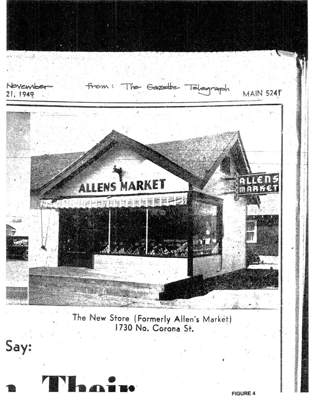
2 Page 48 PROJECT SUMMARY: 1. Project Description: The use variance application proposes a general office or medical office for the existing 2,220 square-foot commercial building at 1730 North Corona Street (FIGURE 1). A specific office or medical use or user is not proposed. 2. Applicant s Project Statement: FIGURE 2 3. City Planning Department s Recommendation: Approve the use variance for a general office or medical office subject to the revisions to the development plan. BACKGROUND: 1. Site Address: 1730 North Corona Street, Patty Jewett neighborhood 2. Existing Zoning/Land Use: R /medical office was the last use. The medical office was recently discontinued and the building is presently vacant. 3. Surrounding Zoning/Land Use: North: R /single family residence South: R /single family residence East: R /single family residence West: R /single family residence 4. Comprehensive Plan/Designated 2020 Land Use: General Residential: LUM 202c indicates the General Residential designation includes supporting commercial uses. 5. Annexation 1872, Town of Colorado Springs 6. Master Plan/Designated Master Plan Land Use: Not applicable 7. Subdivision: 1898, Corona Addition 8. Zoning Enforcement Action: None 9. Physical Characteristics: The 5,000 square-foot property is developed with a 2,200 square-foot commercial structure. STAKEHOLDER PROCESS AND INVOLVEMENT: A previous use variance application for a veterinary clinic, medical office or general office was considered by the Planning Commission at their July 17, 2008 meeting. Staff recommended approval of the application. Two neighborhood meetings were conducted prior to the Commission meeting. Opposition by neighbors to the application was presented at the Planning Commission meeting. The Planning Commission approved the use variance for a veterinary clinic only for the applicants. The decision of the Planning Commission was appealed by both the property owner and the neighbors. The applicants withdrew the application and the appeals were not heard by the City Council. This revised use variance application for general office or medical office (no veterinary clinic) was submitted on September 29, A 500-foot buffer was used and notification was mailed to 95 property owners on two occasions. One neighborhood meeting was held on October 15, 2008 with an attendance of approximately 16 persons. The general office use was acceptable to those present; however opposition was expressed from some of the neighbors for a medical office. At the meeting and in subsequent correspondence to staff the medical use was opposed due to the potential for an increase in activity over a general office. One of the s received is included as FIGURE 3. It is representative of the concerns expressed in the other correspondence. Concerns include too much traffic and insufficient or inappropriate parking fpr a medical office. ANALYSIS OF REVIEW CRITERIA/MAJOR ISSUES/COMPREHENSIVE PLAN CONFORMANCE: 1. Review Criteria/Design & Development Issues: The existing medical office building at 1730 North Corona Street (southwest corner of Corona Street and Espanola Street) was constructed in 1925 as a neighborhood market and was operated as such for the next 41 years. The photograph in FIGURE 4 shows the building as it appeared in Since 1969 the building has been used for a variety of commercial and office uses including a home repair business, offices for a pharmacy, hospital and surgical equipment sales, photography/printing studio, and for the last 14 years, a doctor s office. Based on the Polk Directories the building may have been used residentially in the early 70 s for three or four years, as an individual is listed as the occupant. Since 1975 only commercial or office uses have occupied the site. The City considered past uses of the property as legal nonconforming because of the residential zoning on the property.
3 Page 49 The property has been zoned R since at least The 1925 zone map of the City shows the site in the A zone, which permitted one and two family dwellings, schools, farms and truck farms. The 1925 map also indicates a line of the Colorado Springs and Interurban Railway in Corona Street, just beyond the front door of the market. The use variance granted in 1994 was necessary because a medical office is a more intense use than the prior use of a photography/printing studio. The nonconforming requirements indicate a use may only change to a use of the same or less intensity. The use variance granted by the City Council in 1994 was for a medical office exclusively for Dr. Samuel Rubinson. Additionally a nonuse variance for 0 parking spaces where 11 are required for medical use was also approved. Dr. Rubinson recently closed the medical office and has offered the property for sale. The only permitted uses under the current requirements are the medical office for Dr. Rubinson or a single-family residence per the R zone. As indicated above there is neighborhood opposition to the proposed medical office use because of potential traffic and parking impacts. Traffic The increase in traffic on Corona Street and Espanola Street due to a medical office was evaluated. Listed below are the results of 2-way, 24 hour traffic counts taken on Tuesday, June 3, 2008 near or adjacent to the site: Espanola Street west of Corona Street 1,323 vehicle trips/day (vt/d) Espanola Street east of Corona Street 1,258 vt/d Corona Street north of Espanola Street 481 vt/d Corona Street south of Espanola Street 825 vt/d Both Espanola Street and Corona Street have a pavement width of 58 feet. Pavement width is measured from the face of the curb to the opposite face of the curb. Espanola Street extends from Wood Avenue to Prospect Street (terminating at the Patty Jewett golf course) for a distance of approximately 0.9 mile. Corona Street extends from Monroe Street (adjacent to Bon Park) south to Willamette Street for a distance of approximately 1.6 mile. The characteristics of a Minor Collector Street as indicated in the City s Intermodal Transportation Plan are listed below: Trip length: 1 mile Posted speed: mph Pavement width: 36 feet. Number of lanes: 2-3 Average daily trips: 1,500-3,500 vt/d Both Espanola Street and Corona Street function as, and meet the criteria for a minor collector street; however both streets experience less traffic than what could be accommodated. In the Seventh Edition of the Institute of Traffic Engineers study of parking demand a medical office is estimated to generate vehicle trips per 1,000 square feet. The building at 1730 North Corona Street is 2,200 square feet, thus a potential for approximately 80 trips per day. These trips will be dispersed in 4 different directions: north and south on Corona Street and east and west on Espanola Street, so that no one street experiences the total number of pass-by trips. Assuming the trips are distributed evenly among the streets, the increase to traffic ranges from 1.5% on Espanola Street west of the intersection, to 4.2% on Corona Street north of Espanola Street. These added trips not only represent a negligible increase to the existing amount of traffic on the street, but also result in both streets remaining below the minimum number of trips which could be expected or accommodated on these minor collector streets. Parking A total of 11 parking spaces exist between the two spaces on the property (which require backing into Corona Street) and the nine diagonal spaces adjacent to 1730 North Corona Street and within the rightsof-way of Espanola Street (three spaces) and Corona Street (six spaces). While the 11 spaces should provide ample parking for the majority of the time, an additional 15 on-street parking spaces are located on Espanola Street and Corona Street within approximately 150 feet of the office entry, but in front of
4 Page 50 single-family homes. Staff estimates the on-street parking spaces in front of the homes are vacant over 90% of the time during the typical work day. Since these are public spaces, they are available to the office users. Their occasional use should not significantly diminish the neighbors ability for their visitors and themselves to park on the street in front of or near their home. Medical office uses require 1 parking space per 200 square feet of gross floor area North Corona Street has 2,200 square feet of gross floor area, thus requiring 11 parking spaces. A nonuse variance was approved in 1994 for the medical office with the parking as shown on the development plan. This variance will remain in effect if the proposed use variance is approved. Summary The physical aspects of the site are addressed with the development plan and the recommended revisions, which include limitations to signage and exterior lighting. The property maintains a unique position within the residential neighborhood due to its use of either office or commercial for over 80 years. The proposed medical or general office use can be accommodated without negatively impacting either the adjacent streets or the on-street parking. The application satisfies the review criteria for the approval of a use variance. 2. Conformance with the City Comprehensive Plan: Policy N301 of the Comprehensive Plan states: Develop an appropriate mix of land uses and differing housing types in both new and existing neighborhoods. This project is consistent with this policy by allowing an appropriately sized, medical or general office use to continue within an existing neighborhood with minimal impacts. STAFF RECOMMENDATION: Item No: 4 CPC UV Use Variance Approve the use variance for a medical office or general office at 1730 North Corona Street, based on the finding that the request complies with the review criteria in City Code Section (B), subject to compliance with the following technical and informational modifications: Technical and Informational Modifications to the Development Plan: 1. Note the City file number of CPC UV in the lower right corner. 2. Revise the proposed use note to indicate no telemarketing or medical laboratories are permitted. 3. Revise the note to indicate the nine (instead of eight) adjacent diagonal parking spaces within the rights-of-way shall be maintained by the owner of 1730 North Corona Street and shall include striping and maintenance of the surface. 4. Note the surface material of the area west of the building as concrete. Note the depth of the two parking spaces as a minimum of 20 feet. behind (or to the west) of the sidewalk. 5. Show the location of a solid trash enclosure with a gate. Note the type and height of the fence. 6. Note the maximum signage permitted is one wall sign per street frontage with a maximum sign area of six square feet. Note the sign shall not be illuminated. 7. Note that all exterior lights shall have full cut-off fixtures.
5 Page 51
6 Page 52
7 Page 53
8 Page 54
9 Page 55
10 Page 56
11 Page 57
Article 1 Administration and Enforcement Article 2 Zoning Districts and Map
 CITY OF RICHMOND ZONING ORDINANCE TABLE OF CONTENTS Article 1 Administration and Enforcement... 1-1 Sec. 1.01 Intent and Purpose...1-1 Sec. 1.02 Scope...1-1 Sec. 1.03 Short Title...1-1 Sec. 1.04 Enabling
EUCLID AVENUE PARKING STUDY CITY OF SYRACUSE, ONONDAGA COUNTY, NEW YORK
 EUCLID AVENUE PARKING STUDY CITY OF SYRACUSE, ONONDAGA COUNTY, NEW YORK CITY OF SYRACUSE DEPARTMENT OF PUBLIC WORKS 1200 CANAL STREET EXTENSION SYRACUSE, NEW YORK 13210 DRAFT REPORT DATE: November 13,
City of Memphis On-Street Parking Modification Guidelines
 City of Memphis Effective Date: December 1, 2013 Bicycle/Pedestrian Program 125 N. Main Street Memphis, TN 38103 (901) 576-6710 www.bikepedmemphis.com City of Memphis Executive Summary It is current practice
Roadway Classification Design Standards and Policies. Pueblo, Colorado November, 2004
 Roadway Classification Design Standards and Policies Pueblo, Colorado November, 2004 Table of Contents Page Chapter 1. General Provisions 1.1 Jurisdiction 3 1.2 Purpose and Intent 3 1.3 Modification 3
November 13, Planning and Land Development Regulation Commission (PLDRC)
") 1 of 29 GROWTH AND RESOURCE MANAGEMENT DEPARTMENT PLANNING AND DEVELOPMENT SERVICES DIVISION CURRENT PLANNING ACTIVITY 123 W. Indiana Avenue, DeLand, FL 32720 (386) 943-7059 PUBLIC HEARING: CASE NO: SUBJECT:
1 of 29 GROWTH AND RESOURCE MANAGEMENT DEPARTMENT PLANNING AND DEVELOPMENT SERVICES DIVISION CURRENT PLANNING ACTIVITY 123 W. Indiana Avenue, DeLand, FL 32720 (386) 943-7059 PUBLIC HEARING: CASE NO: SUBJECT:
VILLAGE OF NILES TRAFFIC CALMING POLICY
 INTRODUCTION There is increasing interest across the country in developing new strategies to reduce the speed and amount of traffic in residential neighborhoods. Measurement of speeds, traffic volumes,
Traffic Calming Policy
 Article I. Purpose and Goal. The purpose of this policy is to establish criteria and procedures the City will use to evaluate requests for, and if appropriate, implement traffic calming measures. Neighborhood
July 5, Arthur R. Ware, Jr. Elementary School 2017 Safe Routes to School Walkabout Report
 July 5, 2017 Arthur R. Ware, Jr. Elementary School 2017 Safe Routes to School Walkabout Report 1 Walkabout Report Introduction On April 28, 2017, City, School, and SAWMPO staff met to conduct a Safe Routes
Merrick and Memorial Neighborhood Study 5/14/2014 Public Meeting
 Merrick and Memorial Neighborhood Study 5/14/2014 Public Meeting Study Area April 9 Public Meeting Comments Summary Pedestrian Safety - A Walking Neighborhood Pedestrian traffic is very difficult A need
NEIGHBOURHOOD TRAFFIC COMMITTEE POLICY AND PROCEDURE
 The City of Vaughan 2141 Major Mackenzie Drive Vaughan, Ontario Canada L6A 1T1 Tel (905) 832-2281 NEIGHBOURHOOD TRAFFIC COMMITTEE POLICY AND PROCEDURE REVISED JUNE 2010 APPLICABILITY The Neighbourhood
TRAFFIC CALMING POLICY & PROCEDURES
 TRAFFIC CALMING POLICY & PROCEDURES AS ADOPTED BY MONTCLAIR TOWNSHIP COUNCIL AUGUST 4, 2009 TABLE OF CONTENTS 1. INTRODUCTION... 2 Purpose... 2 Traffic Calming Definition... 2 Statement Of Township Council
City of Edinburg Department of Public Works 415 W. University Dr. Edinburg, TX (956) SPEED HUMPS INSTALLATION POLICY
 SPEED HUMPS INSTALLATION POLICY") City of Edinburg Department of Public Works 415 W. University Dr. Edinburg, TX 78541 (956) 388-8210 SPEED HUMPS INSTALLATION POLICY A. GENERAL Speed humps are an effective and appropriate device for safely
City of Edinburg Department of Public Works 415 W. University Dr. Edinburg, TX 78541 (956) 388-8210 SPEED HUMPS INSTALLATION POLICY A. GENERAL Speed humps are an effective and appropriate device for safely
ARLINGTON COUNTY, VIRGINIA
 ARLINGTON COUNTY, VIRGINIA County Board Agenda Item Meeting of October 15, 2016 DATE: October 7, 2016 SUBJECT: Adoption of amendments to the Master Transportation Plan (MTP) to create a new Pedestrian
7/23/2017 VIA . Michael Hanebutt City of Sacramento Community Development Department 300 Richards Boulevard, 3 rd Floor Sacramento, CA 95811
 7/23/2017 VIA EMAIL Michael Hanebutt City of Sacramento Community Development Department 300 Richards Boulevard, 3 rd Floor Sacramento, CA 95811 RE: 65 th Street Apartments (DR17-220) Dear Mr. Hanebutt:
TRANSPORTATION STANDARDS
 INTRODUCTION LOCAL STREETS ON-STREET PARKING SIDEWALKS STREET LIGHTING STREET FURNISHINGS TRAFFIC CALMING STREET TREES MEDIAN PLANTING BOULEVARD LOCATIONS VILLAGE CENTER STREET LOCATIONS RESIDENTIAL STREET
/ ARLINGTON COUNTY, VIRGINIA
 / ARLINGTON COUNTY, VIRGINIA County Board Agenda Item Meeting of September 24, 2016 DATE: August 11, 2016 SUBJECT: Amendment of the Master Transportation Plan (MTP) Streets Element to include new local
County of Greenville South Carolina. Traffic Calming Program Neighborhood Traffic Education Program and Speed Hump Program
 County of Greenville South Carolina Traffic Calming Program Neighborhood Traffic Education Program and Speed Hump Program (rev) August 2008 I. PURPOSE The potential negative impacts from vehicular traffic
David Hung, Associate Planner City of Sacramento Community Development Department 300 Richards Boulevard, 3 rd Floor Sacramento, CA
 June 13, 2016 VIA EMAIL David Hung, Associate Planner City of Sacramento Community Development Department 300 Richards Boulevard, 3 rd Floor Sacramento, CA 959811 RE: Fire Station 14 (DR16-128) Dear Mr.
INTRODUCTION THOROUGHFARE SYSTEM CLASSIFICATIONS
 INTRODUCTION The thoroughfare plan will assist public officials in the development of a specialized system for efficient and safe movement of vehicular traffic while minimizing potential conflicts with
STATE OF VERMONT ENVIRONMENTAL COURT } } } } } Decision and Order
 STATE OF VERMONT ENVIRONMENTAL COURT In re: Appeal of Ted S. Gladstone and Kathleen Hoisington Docket No. 190-10-99 Vtec Decision and Order Appellants appealed from a decision of the Planning Commission
Traffic Circulation & Pedestrian Safety Study
 Lyons Township High School North Campus La Grange, Illinois Parking Lot Vaughan Building N Main Building Prepared for: Prepared by: July 23, 2015 Contents List of Figures, iii 1. Introduction...1 2. Existing
TOWN OF PAYSON TRAFFIC CALMING MANUAL
 TOWN OF PAYSON TRAFFIC CALMING MANUAL APPROVED BY THE PAYSON TOWN COUNCIL SEPTEMBER 6, 2007 TOWN OF PAYSON TRAFFIC CALMING POLICY 1.0 Introduction Traffic Calming involves retrofitting physical devices
City of Turlock Traffic Calming Program
 Table of Contents Introduction... 3 Definitions... 3 Purpose... 3 Goals and Objectives... 3 Policy Statements... 4 Minimum Qualifying Criteria... 6 Traffic Calming Request Process... 7 Step No. 1: Complete
CITY OF WEST LAKE HILLS. Forest View Neighborhood Traffic Calming Study
 CITY OF WEST LAKE HILLS 901 South Mopac Expressway Building V, Suite 220 Austin, Texas 78746 Texas P.E. Firm Registration No. F-929 Klotz Associates Final Report Submittal: March 20, 2015 Revised Final
TRAFFIC CALMING GUIDE FOR TORONTO CITY OF TORONTO TRANSPORTATION SERVICES DIVISION
 TRAFFIC CALMING GUIDE FOR TORONTO CITY OF TORONTO TRANSPORTATION SERVICES DIVISION CITY OF TORONTO TRANSPORTATION SERVICES DIVISION 2016 TRAFFIC CALMING GUIDE FOR TORONTO TABLE OF CONTENTS Introduction
122 Avenue: 107 Street to Fort Road
 : 107 Street to Fort Road November 24, 2015 4:30 8:00 p.m. Meeting Purpose Summarize project work completed to date Share results of public input from Phase 1 Share the draft concept plan and proposed
County of Spartanburg South Carolina
 County of Spartanburg South Carolina Traffic Calming Program June 2012 (Revised/Program on Hold) PURPOSE The potential negative impacts from vehicular traffic on residential roads have been a longstanding
TOWN OF CHAPEL HILL POLICY AND PROCEDURES FOR TRAFFIC CALMING MEASURES
 TOWN OF CHAPEL HILL POLICY AND PROCEDURES FOR TRAFFIC CALMING MEASURES (Adopted by the Town Council on June 30, 2004) (Revised December 6, 2010) (Revised February 8, 2016) POLICY AND PROCEDURES FOR TRAFFIC
CITY OF OTTAWA ROADWAY MODIFICATION APPROVAL UNDER DELEGATED AUTHORITY
 RMA-2015-ATM-038 CITY OF OTTAWA ROADWAY MODIFICATION APPROVAL UNDER DELEGATED AUTHORITY DATE: April 22, 2015 SUBJECT Approval of Roadway Modifications Recommended through an Area Traffic Management Study
SECTION 3 STREET DESIGN
 3.01 GENERAL SECTION 3 STREET DESIGN For purposes of geometric and structural design, streets shall be classified according to the following table. The City Engineer will determine the class of all proposed
Access requests to County streets and roadways are processed through one of the following methods:
 13.1 GENERAL APPLICATION PROCESS Access requests to County streets and roadways are processed through one of the following methods: A. Planned Developments may set general locations for access points.
MUNICIPALITY OF ANCHORAGE Traffic Department MEMORANDUM
 MUNICIPALITY OF ANCHORAGE DATE: MEMORANDUM TO: FROM: SUBJECT: Anchorage Contractors, Builders, Designers, and Land Owners Robert E. Kniefel, P.E., Municipal Traffic Engineer Municipal Driveway Standards
City of Vestavia Hills Traffic Calming Policy for Residential Streets
 City of Vestavia Hills Traffic Calming Policy for Residential Streets PURPOSE: The purpose of the Traffic Calming Policy for Residential Streets is to address safety concerns related to vehicular traffic
BUSINESS OF THE CITY COUNCIL CITY OF MERCER ISLAND, WA
 BUSINESS OF THE CITY COUNCIL CITY OF MERCER ISLAND, WA AB 4087 May 1, 2006 Regular Business PEAK PROJECT UPDATE - CITY RELATED ISSUES Proposed Council Action: Receive update. No action required. DEPARTMENT
AGENDA ITEM G-2 Public Works
 AGENDA ITEM G-2 Public Works STAFF REPORT City Council Meeting Date: 12/6/2016 Staff Report Number: 16-214-CC Regular Business: Approve the Oak Grove University Crane Bike Improvement Concept Plan, authorize
Street Paving and Sidewalk Policy
 City Commission Policy 600 Street Paving and Sidewalk Policy DEPARTMENT: Public Works DATE ADOPTED: June 7, 1995 DATE OF LAST REVISION: December 10, 2014 Policy No. 600.01 AUTHORITY: PASS City of Tallahassee-Leon
ACHD Board of Commissioners Stacey Yarrington, Planner III Tandem Ridge/ EPP / PP-07-16/ RZ-12-16/ CPA-01-16/ A-07-16
 Development Services Department DATE: December 14, 2016 TO: FROM: SUBJECT: ACHD Board of Commissioners Stacey Yarrington, Planner III Tandem Ridge/ EPP16-0012/ PP-07-16/ Executive Summary: This is an annexation,
Circular Turning Space. 8 Significant Changes to the ICC A
 8 Significant Changes to the ICC A117.1 2017 304.3.1 Circular Turning Space CHANGE TYPE: Modification CHANGE SUMMARY: Within new buildings, the size of a circular turning space has been increased from
Tonight is for you. Learn everything you can. Share all your ideas.
 Strathcona Neighbourhood Renewal Draft Concept Design Tonight is for you. Learn everything you can. Share all your ideas. What is Neighbourhood Renewal? Creating a design with you for your neighbourhood.
5 Transit & Traffic. Overview
 5 Transit & Traffic Overview Montgomery Place s roadways and overall traffic circulation are unique in the city due to the narrow streets and avenues with boulevards; however, no sidewalks or curbs in
DRAFT - CITY OF MEDFORD TRANSPORTATION SYSTEM PLAN Roadway Cross-Sections
 Roadway Cross-Sections Medford s roadway cross-section standards apply to new and reconstructed roads. The crosssections take into consideration roadway function and operational characteristics, including
Third Street Bridge & Corridor Project
 Third Street Bridge & Corridor Project Preparation for the FY2018 budget to commence October 1, 2017, includes funding to address a project that has been considered since 1994. The Third Street bridge
Agenda. Overview PRINCE GEORGE S PLAZA METRO AREA PEDESTRIAN PLAN
 PRINCE GEORGE S PLAZA METRO AREA PEDESTRIAN PLAN May 28, 2008 Agenda Welcome and introductions Project overview and issue identification Planning context and strengths Design challenges and initial recommendations
THE CORPORATION OF THE CITY OF KENORA BY-LAW NUMBER
 THE CORPORATION OF THE CITY OF KENORA BY-LAW NUMBER 94-2006 Being a by-law to provide that the Line Fences Act does not apply to all of Kenora and for the regulation, erection and maintenance of fences
December 15, City of Ottawa Planning and Growth Management Branch 110 Laurier Ave. W., 4 th Floor Ottawa, ON K1P 1J1
 December 15, 2017 City of Ottawa Planning and Growth Management Branch 110 Laurier Ave. W., 4 th Floor Ottawa, ON K1P 1J1 Attention: Mr. Wally Dubyk, C.E.T. Project Manager, Infrastructure Approvals Dear
Anholm Bikeway Plan Planning Commission Meeting Summary (8/14/18)
") Anholm Bikeway Plan Planning Commission Meeting Summary (8/14/18) Overview: On August 14, 2018, the Planning Commission considered plans for the middle section of the Anholm Bikeway Plan, focusing on the
Anholm Bikeway Plan Planning Commission Meeting Summary (8/14/18) Overview: On August 14, 2018, the Planning Commission considered plans for the middle section of the Anholm Bikeway Plan, focusing on the
BOI / DRH S. 13 th Street Mixed use office/retail development with residential dormitory
 Jim D. Hansen, President Sara M. Baker, Vice President Rebecca W. Arnold, Commissioner Kent Goldthorpe, Commissioner Paul Woods, Commissioner October 21, 2015 To: Rick Nesser ISS River Partners, LLC 8312
Table of Contents City of Shelbyville Unified Development Ordinance
 City of Shelbyville Unified Development Ordinance 2012, Bradley E. Johnson, AICP Table of Contents 1: Ordinance Foundation 1.01 Title... 1-2 1.02 Unified Development Ordinance... 1-2 1.03 Defined Words...
SECTION 1 - TRAFFIC PLANNING
 SECTION 1 - TRAFFIC PLANNING 1.1 TRAFFIC OPERATIONS 1.1.1 Roadway Functional Classification The Multnomah County Comprehensive Framework Plan s Policy 34: Trafficways and the Functional Classification
Dundas. Plan Propose. ed North Northea Town
 Dundas Trafalgar Inc. Transit Facilities Plan Propose ed North Oakville Residential Subdivision Northea ast Corner of Dundas Street and Trafalgar Road Town of Oakville 12237 December 2012 Table of Contents
Byron Avenue. Public Meeting. Thursday June 16, Traffic Calming Design Sherbourne Road to Island Park Drive
 Byron Avenue Traffic Calming Design Sherbourne Road to Island Park Drive Public Meeting Thursday June 16, 2016 Our Lady of Fatima Parish 153 Woodroffe Avenue 6 9pm 1 Project Summary Area Projects Background
Recommended Roadway Plan Section 2 - Land Development and Roadway Access
 Recommended Roadway Plan Section 2 - Land Development and Roadway Access SECTION 2 Land Development and Roadway Access 2.1 Land Use and Access Management The Federal Highway Administration (FHWA) defines
City of Tamarac, Florida Traffic Calming Policy
 City of Tamarac, Florida Traffic Calming Policy Temp. Reso. 12614 Exhibit 1 I. Introduction: The City of Tamarac recognizes that the conditions of residential streets can greatly affect neighborhood livability
T A B L E OF C O N T E N T S
 T A B L E OF C O N T E N T S PART III SUBDIVISION REGULATIONS OF THE DEPARTMENT OF PUBLIC WORKS, C & C D PAGE PAGE Responsibility for Development of Streets......... 29 Right-of-Way Widths...... 37 Purpose...........
Americans with Disabilities Act Transition Plan for Public Right-of-Way Improvements
 Americans with Disabilities Act Transition Plan for Public Right-of-Way Improvements Prepared by: Public Works Department Engineering Division October 2015 Table of Contents Section I Introduction.. 3
Exhibit 1 PLANNING COMMISSION AGENDA ITEM
 Exhibit 1 PLANNING COMMISSION AGENDA ITEM Project Name: Grand Junction Circulation Plan Grand Junction Complete Streets Policy Applicant: City of Grand Junction Representative: David Thornton Address:
June 29, Dear Mr. Walter:
 From: CountyBoard@arlingtonva.us To: chickandsandy@msn.com Subject: County Board Response Regarding the Arlington Ridge Road Improvement Project (Intranet Quorum IMA00252707) Date: Wed, 29 Jun 2011 08:09:53-0400
APPLICATION NUMBER A REQUEST FOR
 APPLICATION NUMBER 5270 A REQUEST FOR FRONT YARD SETBACK AND SIDE YARD SETBACK VARIANCES TO ALLOW THE CONSTRUCTION OF A 6 SOLID WOODEN FENCE ON THE FRONT PROPERTY LINE (LOT 1 OF CLOISTER SUBDIVISION) AND
CITY OF ROCK HILL, SOUTH CAROLINA. Neighborhood Traffic Calming Program A Policy for Use of Traffic Calming on Local (Residential) Streets
 Streets") CITY OF ROCK HILL, SOUTH CAROLINA Neighborhood Traffic Calming Program A Policy for Use of Traffic Calming on Local (Residential) Streets I. Statement of Purpose: This program provides a process and a
CITY OF ROCK HILL, SOUTH CAROLINA Neighborhood Traffic Calming Program A Policy for Use of Traffic Calming on Local (Residential) Streets I. Statement of Purpose: This program provides a process and a
FORM A PASCO COUNTY ACCESS CONNECTION PERMIT APPLICATION
 FORM 901.3.A PASCO COUNTY ACCESS CONNECTION PERMIT APPLICATION The following information is required from all applicants directly or indirectly accessing any collector or arterial road or as otherwise
Driveway Design Criteria
 Design Manual Chapter 5 - Roadway Design 5L - Access Management 5L-4 Driveway Design Criteria A. General For efficient and safe operations, access drives and minor public street intersections can be improved
Borough of Danville, PA Traffic Calming Program Guidelines
 Borough of Danville, PA Traffic Calming Program Guidelines Adopted by Borough Council on 1 INTRODUCTION Speeding Traffic is a major concern in the Borough of Danville because of its detrimental impacts
Appendix 5 Traffic Assessment
 Appendix 5 Traffic Assessment 44 Harrison Transportation Best Start Educare Shelly Bay Road Beachlands Transportation Assessment Report September 2017 PO Box 11 557 Palm Beach Papamoa 3151 Reference: 187
AGENDA REPORT. Issue: Discussion of potential improvements on Barnwell Road at Niblick Drive
 AGENDA REPORT To: From: By: Honorable Mayor and City Council Members Warren Hutmacher, City Manager Tom Black, Public Works Director Date: March 23, 2016 Agenda: March 28, 2016 WORK SESSION AGENDA: Barnwell
Chair and Members of Transportation Standing Committee. Bruce Zvaniga, P.Eng., Director, Transportation and Public Works
 P.O. Box 1749 Halifax, Nova Scotia B3J 3A5 Canada Item No. 12.1.1 Transportation Standing Committee December 7, 2017 TO: Chair and Members of Transportation Standing Committee SUBMITTED BY: ORIGINAL SIGNED
A plan for improved motor vehicle access on Railroad Avenue in Provincetown
 A plan for improved motor vehicle access on Railroad Avenue in Provincetown February 2011 A plan for improved motor vehicle access on Railroad Avenue in Provincetown INTRODUCTION AND PROBLEM IDENTIFICATION
Traffic Impact Memorandum. May 22, 2018
 BISHOP PROFESSIONAL DEVELOPMENT BUILDING Proposed Land-use Change & Parking Modification 3601 SW 31st Street Topeka, Kansas 66614 CFS Project No. 185077 Traffic Impact Memorandum May 22, 2018 Prepared
This Chapter sets forth the minimum design, technical criteria and specifications to be used in the preparation of all roadway plans.
 4.1 GENERAL This Chapter sets forth the minimum design, technical criteria and specifications to be used in the preparation of all roadway plans. These Roadway Standards are for new construction and modification
City of Elizabeth City Neighborhood Traffic Calming Policy and Guidelines
 City of Elizabeth City Neighborhood Traffic Calming Policy and Guidelines I. Purpose: The City of Elizabeth City is committed to ensure the overall safety and livability of residential neighborhoods. One
Item No Halifax Regional Council January 16, 2018 January 30, 2018
 P.O. Box 1749 Halifax, Nova Scotia B3J 3A5 Canada Item No. 9.2.1 Halifax Regional Council January 16, 2018 January 30, 2018 TO: Mayor Savage and Members of Halifax Regional Council Original Signed SUBMITTED
DEPARTMENT OF PUBLIC WORKS Carroll County, Maryland
 DEPARTMENT OF PUBLIC WORKS Carroll County, Maryland Prepared by the Bureau of Engineering 225 North Center Street, Room 221, Westminster, MD 21157 (410) 386-2157 e-mail: trafficcalming@ccg.carr.org http://ccgovernment.carr.org/trafficcalming
11/28/2016 VIA
 11/28/2016 VIA EMAIL Ethan Meltzer, Assistant Planner City of Sacramento Community Development Department 300 Richards Blvd., 3 rd Floor Sacramento, Ca 95811 RE: Natomas Corporate Center Commercial Building
TRAFFIC STUDY. Birch Bluff Road / Pleasant Avenue 01/15/2018. City of Tonka Bay 4901 Manitou Road Tonka Bay, MN WSB PROJECT NO.
 TRAFFIC STUDY Birch Bluff Road / Pleasant Avenue 01/15/2018 City of Tonka Bay 4901 Manitou Road Tonka Bay, MN 55331 WSB PROJECT NO. 10805-000 Birch Bluff Road/ Pleasant Avenue Traffic Study For: City of
MAJOR THOROUGHFARE PLAN
 MAJOR THOROUGHFARE PLAN Adopted by City Commission On November 21, 2005 Per Resolution No. 4420 Amendment to the Comprehensive Community Development Plan City of Hobbs City of Hobbs MAJOR THOROUGHFARE
Corporate. Report COUNCIL DATE: May 25, 1998 NO: R1500 REGULAR COUNCIL. TO: Mayor & Council DATE: April 27, 1998
 R1500 : Traffic Safety at 25 Avenue and 128 Street Intersection Corporate NO: R1500 Report COUNCIL DATE: May 25, 1998 REGULAR COUNCIL TO: Mayor & Council DATE: April 27, 1998 FROM: General Manager, Engineering
ARLINGTON COUNTY, VIRGINIA
 ARLINGTON COUNTY, VIRGINIA County Board Agenda Item Meeting of July 8, 2006 Date: June 29, 2006 SUBJECT: Approval of Spring Traffic-Calming Projects C. M. RECOMMENDATION: 1. Approve traffic-calming projects
MINERAL AVENUE CORRIDOR ASSESSMENT STUDY IMPLEMENTATION STRATEGY
 MINERAL AVENUE CORRIDOR ASSESSMENT STUDY IMPLEMENTATION STRATEGY INTRODUCTION City Personnel Sign-in Sheet Comment Forms Please Write Down Any Feedback INTRODUCTION List of Topics for Presentation Study
Development Services Department
 Kent Goldthorpe, President Paul Woods, Vice President Rebecca W. Arnold, Commissioner Sara M. Baker, Commissioner Jim D. Hansen, Commissioner July 21, 2016 Development Services Department To: From: ACHD
Neighborhood Pedestrian Safety and Traffic Calming Study
 Neighborhood Pedestrian Safety and Traffic Calming Study for the area bounded by Foster Avenue, Bedford Avenue, Farragut Road and Ocean Avenue Flatbush, Brooklyn, New York prepared by Michael King, miking@trafficcalmer.com
NJDOT Complete Streets Checklist
 Background The New Jersey Department of Transportation s Complete Streets Policy promotes a comprehensive, integrated, connected multi-modal network by providing connections to bicycling and walking trip
Glebe Neighbourhood Cycling Plan
 Glebe Neighbourhood Cycling Plan Summary of Public Comments received after June 5 th Public Information Session Comment STUDY NETWORK CS9, CS8, E, E0 CS4, E CS4 CS8 E Suggestions for alternate cycling
WELCOME Public Information Centre
 WELCOME Public Information Centre Fernforest Drive Brampton Soccer Centre Community Room #2 Tuesday January 19, 2016 6:30 p.m.to 9:00 p.m. Please sign in Neighbourhood Traffic Calming Guide Background
3.1 TRAFFIC CALMING PROCESS SUMMARY
 SECTION 3 3.0 TRAFFIC CALMING 3.1 TRAFFIC CALMING PROCESS SUMMARY Traffic calming is a means in which to reduce speeds and minimize vehicular traffic on local neighborhood streets. Citizen involvement
Construction Staging Area Vaughan Road
 REPORT FOR ACTION Construction Staging Area - 109 Vaughan Road Date: May 25, 2017 To: Toronto and East York Community Council From: Acting Director, Transportation Services, Toronto and East York District
Development Services Department
 Kent Goldthorpe, President Paul Woods, Vice President Rebecca W. Arnold, Commissioner Sara M. Baker, Commissioner Jim D. Hansen, Commissioner July 28, 2016 Development Services Department To: From: ACHD
Improving Cyclist Safety at the Dundas Street West and Sterling Road Intersection
 STAFF REPORT ACTION REQUIRED Improving Cyclist Safety at the Dundas Street West and Sterling Road Intersection Date: August 17, 2012 To: From: Wards: Reference Number: Public Works and Infrastructure Committee
TOWN OF MORAGA MORAGA WAY AND CAMINO PABLO/CANYON ROAD IMPROVEMENTS Town Council Meeting March 13, 2019
 TOWN OF MORAGA MORAGA WAY AND CAMINO PABLO/CANYON ROAD IMPROVEMENTS Town Council Meeting March 13, 2019 1 Edric Kwan, Public Works Director Josh Peterman, Principal, Fehr and Peers Shawn Knapp, Senior
Vehicular turning and path of travel with a proposed curb bulb on the southwest corner of Mount Diablo Boulevard and Dewing Avenue.
 October 3, 2014 James Shively Stantec 100 California Street, Suite 1000, San Francisco CA 94111-4505 Subject: Traffic Study for Proposed Lafayette Chase Bank Dear Mr. Shively: Pursuant to your request,
Implementing the Three Es of School Zone Traffic Calming
 Implementing the Three Es of School Zone Traffic Calming Use this evaluation tool as a guide to analyze the specific safety needs of your school. SCHOOL PROFILE School Name: School District: Address: Phone
PRINCE GEORGE S PLAZA METRO AREA PEDESTRIAN PLAN
 PRINCE GEORGE S PLAZA METRO AREA PEDESTRIAN PLAN May 28, 2008 Agenda Welcome and introductions Project overview and issue identification Planning context and strengths Design challenges and initial recommendations
TRAFFIC CONTROL DEVICES ON EDGEWATER BOULEVARD AT PORT ROYAL AVENUE (NORTH)
") Attachment 2 DATE: August 6, 2012 TO: VIA: FROM: SUBJECT: Mayor and Members of the City Council James C. Hardy, City Manager Ramon Towne, Director of Public Works Leah Edwards, Assistant Engineer TRAFFIC
Attachment 2 DATE: August 6, 2012 TO: VIA: FROM: SUBJECT: Mayor and Members of the City Council James C. Hardy, City Manager Ramon Towne, Director of Public Works Leah Edwards, Assistant Engineer TRAFFIC
SAN FRANCISCO MUNICIPAL TRANSPORTATION AGENCY
 THIS PRINT COVERS CALENDAR ITEM NO. : 12 DIVISION: Sustainable Streets BRIEF DESCRIPTION: SAN FRANCISCO MUNICIPAL TRANSPORTATION AGENCY Approving the traffic modifications associated with the Dolores Street
CITY MANUALS AND STANDARDS REVIEW
 GEORGETOWN SIDEWALK MASTER PLAN CITY MANUALS AND STANDARDS REVIEW RESOURCES AND STANDARDS As part of the Master Plan process, a review and evaluation of current City documents and policies relevant to
Houma-Thibodaux Metropolitan Planning Organization STP<200K Funding Application APPLICATION
 APPLICATION HOUMA-THIBODAUX METROPOLITAN PLANNING ORGANIZATION (HTMPO) FOR SURFACE TRANSPORTATION PROGRAM (STP
ADA Transition Plan. City of Gainesville FY19-FY28. Date: November 5, Prepared by: City Of Gainesville Department of Mobility
 ADA Transition Plan FY19-FY28 Date: November 5, 2018 Prepared by: City Of Gainesville Department of Mobility 1.0 INTRODUCTION 1.1 BACKGROUND The federal statute known as the Americans with Disabilities
12/13/2018 VIA
 12/13/2018 VIA EMAIL Daniel Abbes, Assistant Planner City of Sacramento community Development Department 300 Richards Blvd., 3 rd Floor Sacramento, CA 95811 RE: Bruceville Apartments (P18-073) Dear Mr.
CITY OF COCONUT CREEK IMPLEMENTATION GUIDELINES FOR TRAFFIC CALMING
 CITY OF COCONUT CREEK IMPLEMENTATION GUIDELINES FOR TRAFFIC CALMING I. Introduction: The City of Coconut Creek recognizes that the conditions of residential streets can greatly affect neighborhood livability;
Lake Whitney Elementary School
 Lake Whitney Elementary School SCHOOL ROUTE PLAN For LAKE WHITNEY ELEMENTARY SCHOOL LOCATION 18 ORANGE COUNTY Prepared for: ORANGE COUNTY SCHOOL ASSESSMENT PROGRAM ORANGE COUNTY PUBLIC WORKS Traffic Engineering
Item No. 14 Town of Atherton
 Item No. 14 Town of Atherton CITY COUNCIL STAFF REPORT CONSENT AGENDA TO: THROUGH: FROM: HONORABLE MAYOR AND CITY COUNCIL GEORGE RODERICKS, CITY MANAGER MICHAEL KASHIWAGI, COMMUNITY SERVICES DIRECTOR MARTY
Water Street Promenade Engineering and Design Services
 Preliminary Design Presentation Parking & Traffic Safety Committee Water Street Promenade Engineering and Design Services July 16,2014 November 3, 2016 Education / Infrastructure / Innovation 1 Project