ROAD SAFETY AUDIT. Northampton Road (Route 9) at University Drive and Snell Street Town of Amherst. November 15, Prepared For: MassDOT
|
|
|
- Rosaline King
- 6 years ago
- Views:
Transcription

1 ROAD SAFETY AUDIT Northampton Road (Route 9) at University Drive and Snell Street Town of Amherst November 15, 2016 Prepared For: MassDOT Prepared By: Greenman-Pedersen, Inc. 181 Ballardvale Street, Suite 202 Wilmington, MA 01887
2 Road Safety Audit Route 9 at University Drive / Snell Street, Amherst, MA Table of Contents Contents Background... 1 Project Data... 1 Project Location and Description... 3 Northampton Road (Route 9/116)... 3 University Drive... 3 Snell Street... 4 Northampton Road (Route 9/116) / University Drive / Snell Street... 4 Traffic Volumes... 5 Collision Data... 5 Audit Observations and Potential Safety Enhancements... 9 Vehicle Storage Lanes... 9 Lane Drop Channelized Right-Turn Lane Signal Timing Signal Equipment Condition and Location U-Turns Pedestrian and Bicycle Accessibility Sight Distance and Visibility Pavement Markings Vehicle Speeds Solar Glare Driver Distraction Miscellaneous Observations Summary of Road Safety Audit... 27
3 Road Safety Audit Route 9 at University Drive / Snell Street, Amherst, MA List of Appendices Appendix A. Appendix B. Appendix C. Appendix D. RSA Meeting Agenda RSA Audit Team Contact List Detailed Crash Data Additional Information List of Figures Figure 1: Locus Map... 7 Figure 2: Peak Hour Volume Diagram... 8 List of Tables Table 1: Participating Audit Team Members... 2 Table 2: Traffic Volume Summary... 5 Table 3: Estimated Time Frame and Costs Breakdown Table 4: Potential Safety Enhancement Summary... 28
4 Road Safety Audit Route 9 at University Drive / Snell Street, Amherst, MA Background Greenman-Pedersen, Inc. is currently in the process of preparing preliminary design for a roadway improvement project along Northampton Road (Route 9/116) in Amherst, Massachusetts as part of the Massachusetts Department of Transportation (MassDOT) Project # The project consists of the reconstruction and improvements of approximately 0.8 miles of Northampton Road (Route 9/116) between University Drive and South Pleasant Street (Route 116). The improvements are intended to incorporate a Complete Streets approach to the design. The intersection of Northampton Road (Route 9/116) / University Drive / Snell Street (Figure 1, Page 7), which is part of the study area for this project, has been identified by MassDOT as a high-crash location and is therefore eligible for funding through the Highway Safety Improvement Program (HSIP). MassDOT guidelines require that a Road Safety Audit (RSA) be conducted during the preliminary design stages for any MassDOT-funded project that is considered HSIP-eligible. To be categorized as HSIP eligible, an intersection must be within the top five percent of crash clusters in its respective Regional Planning Commission s (RPC s) boundaries. The Northampton Road (Route 9/116) / University Drive / Snell Street intersection is considered HSIP-eligible based on MassDOT s online database and recorded crash cluster data from , , and The Federal Highway Administration (FHWA) defines an RSA as a formal safety performance examination of an existing or future road or intersection by an independent, multidisciplinary team. Consistent with MassDOT standards, this RSA was conducted during the preliminary design (pre-25% Design) state to allow recommendations contained within this RSA to be incorporated into the design of improvements along Northampton Road (Route 9/116). Recommendations from the RSA that will be included in the design are typically added to the plan revisions prior to the Design Public Hearing in order to give the most realistic presentation to the public. Project Data Greenman-Pedersen, Inc. (GPI) of Wilmington, Massachusetts facilitated an RSA on Thursday, September 22, 2016 at the Northampton Road (Route 9/116) / University Drive / Snell Street intersection, with the pre- and post-audit meetings held in the Town Room at the Amherst Town Hall on Boltwood Avenue in Amherst, Massachusetts. A copy of the RSA agenda can be found in Appendix A. As indicated in Table 1, the audit team was comprised of a cross-section of state, regional, and local engineering, planning, enforcement, maintenance, and emergency response professionals, and was assembled in conjunction with input from the MassDOT Traffic Safety Management Unit. Contact information for all audit team members is provided in Appendix B. Page 1
5 Road Safety Audit Route 9 at University Drive / Snell Street, Amherst, MA Table 1: Participating Audit Team Members Audit Team Member Agency/Affiliation Christine Brestrup Christine Gray-Mullen Guilford Mooring Todd Lang Khyati Parma Josh Rickman Jamin Carroll Glenn Barrington Gary Hebert Luke Hayes Town of Amherst Planning Department Town of Amherst Planning Board & Public Works Committee Town of Amherst Department of Public Works Town of Amherst Police Department Pioneer Valley Planning Commission (PVPC) Pioneer Valley Transit Authority (PVTA) PVTA / Valley Area Transit Company (VATCo) University of Massachusetts (UMass) Transit Massachusetts State Police MassDOT District 2 Traffic Laura Hanson MassDOT District 2 Adam Prichard Elsa Chan Lisa Schletzbaum Rebecca Brown Lindsey Barbee Zachary Greene MassDOT Safety MassDOT Safety MassDOT Safety Greenman-Pedersen, Inc. (GPI) Greenman-Pedersen, Inc. (GPI) Greenman-Pedersen, Inc. (GPI) RSA participants were provided with materials to review prior to the audit meeting, which included: Weekday morning, weekday evening, and Saturday midday peak period traffic volume counts, including vehicular, truck, bus, pedestrian, and bicycle volumes, Collision diagram summarizing location, type, and severity of the collisions occurring at the intersection between 2011 and 2015, Summary table of all reported crashes between 2011 and 2015 including date, day of week, time of day, type of collision, lighting condition, weather, roadway surface condition, crash severity, age of drivers, report number, and brief narrative description of the collision, Histograms and charts summarizing the crash month, day of week, time of day, manner of collision, lighting condition, weather condition, and roadway surface condition, MassDOT s Safety Review Prompt List, and RSA Agenda Participants were also encouraged to visit the site prior to the audit to review safety elements of the intersection and consider items listed on MassDOT s Safety Review Prompt List during their visits. A pre-audit meeting was held at 1:00 PM in the Town Room of the Amherst Town Hall on Thursday, September 22, 2016 to discuss the audit process, review the distributed materials, identify the collision patterns observed at the intersection, and discuss safety issues that audit participants had experienced Page 2
6 Road Safety Audit Route 9 at University Drive / Snell Street, Amherst, MA individually. The pre-meeting was immediately followed by a site visit to observe the operations and safety of the audit location. Handwritten notes and photographs were collected to document the observations made by the audit team members. The group walked through the intersection together noting any factors that may be contributing to the collision patterns identified during the pre-audit meeting, as well as any items that may present a potential safety risk in the future. The audit team returned to the Amherst Town Hall following the audit field visit for a post-audit meeting, which included a review of the observations made by the team in the field and discussion of potential improvements to reduce collisions and enhance the safety of the RSA location. Project Location and Description The RSA focused on the intersection of Northampton Road (Route 9/116), University Drive, and Snell Street. A Site Location Map depicting the RSA location in relation to the surrounding streets is provided in Figure 1. Northampton Road (Route 9/116) Northampton Road (Route 9/116) in the vicinity of the RSA intersection is an east-west principal arterial roadway, maintained by the Massachusetts Department of Transportation (MassDOT). Northampton Road (Route 9/116) provides a connection between Route 116 / Russell Street in Hadley to the west and South Pleasant Street / College Street (Route 9) to the east. West of University Drive, Northampton Road (Route 9/116) generally contains two travel lanes in each direction separated by a raised median, with dedicated turning lanes at intersections. East of University Drive, Northampton Road consists of one travel lane in each direction, separated by a single dashed yellow centerline, with a downhill grade approaching the intersection. A 5-foot asphalt sidewalk, separated by a grass strip, is provided along the northerly side of Northampton Road (Route 9/116) east of University Drive and along both sides of Northampton Road (Route 9/116) west of University Drive. The posted speed limit along Northampton Road (Route 9/116) is 40 miles per hour (mph), which is consistent with MassDOT s speed regulations. Land uses along Northampton Road (Route 9/116) consist of a mix of retail, commercial, residential, and educational. University Drive University Drive is a north-south urban minor arterial, maintained by the Town of Amherst. University Drive provides a connection between Northampton Road (Route 9/116) to the south and Massachusetts Avenue to the north. University Drive generally consists of one travel lane in each direction, separated by a double-yellow centerline and 2- to 3-foot shoulders. A parallel frontage road is provided along the westerly side of University Drive between the Big Y Supermarket and Amity Street as a means of access management to minimize turning movements along University Drive. A 5- to 6-foot paved sidewalk is provided along both sides of University Drive from Northampton Road (Route 9/116) to Amity Street. In addition, a dedicated separated bike path with the local name of UMass Connector Bikeway or Art Swift Bike Connector, and recently installed signage for the Connecticut River Valley Greenway, is provided along the easterly side of University Drive between Northampton Road (Route 9/116) and Amity Street. The sidewalk and separated bike path transition to a shared-used pathway that runs along the easterly side Page 3
7 Road Safety Audit Route 9 at University Drive / Snell Street, Amherst, MA of University Drive between Amity Street and Massachusetts Avenue. The posted speed limit along University Drive is 30 mph between Northampton Road (Route 9/116) and the Amherst Technology Park. The posted speed limit along University Drive north of the Amherst Technology Park is 35 mph. Land uses along University Drive consist of University of Massachusetts (UMass) Amherst student residences, Warren McGuirk Alumni Stadium, Sortino Field, U.S. Post Office, and other retail and commercial uses. Snell Street Snell Street is an east-west local roadway, maintained by the Town of Amherst. Snell Street provides a connection between Northampton Road (Route 9/116) to the west and South Pleasant Street (Route 116) to the east. Snell Street provides one lane in each direction, separated by a double-yellow centerline, with no shoulders. A 5-foot paved sidewalk, separated by a grass strip, is provided along the southerly side of Snell Street between Woodside Avenue and South Pleasant Street (Route 116). The Norwottuck Rail Trail crosses over Snell Street just west of Moody Field Road and then runs parallel to Snell Street to the north between Moody Field Road and South Pleasant Street (Route 116). The Connecticut River Valley Greenway path runs along the northerly side of Snell Street between the Norwottuck Rail Trail and Northampton Road (Route 9/116). The posted speed limit along Snell Street is 25 mph. Land uses along Snell Street are mostly residential. Northampton Road (Route 9/116) / University Drive / Snell Street University Drive and Snell Street intersect Northampton Road (Route 9/116) to form a four-way, signalized intersection. The Northampton Road (Route 9/116) eastbound approach consists of a 12-foot exclusive left-turn lane, a 12-foot through lane, and an 18-foot wide shared through/right-turn lane. Due to its width, vehicles were observed utilizing the shared through/right-turn lane as a through and separate right-turn lane during the RSA field visit. The Northampton Road (Route 9/116) westbound approach consists of a 12-foot shared left-turn/through lane and a 13-foot shared through/right-turn lane. Directional travel along Northampton Road (Route 9/116) west of the intersection is separated by a raised median and guardrail, while directional flow east of the intersection is separated by a raised median, tapering back to a dashed yellow centerline. The Snell Street northbound approach provides an 11.5-foot exclusive left-turn lane and a 13-foot shared through/right-turn lane. Directional flow on Snell Street near the intersection is separated by a 20-foot grass median. The University Drive southbound approach provides an 11-foot exclusive left-turn lane, an 11-foot through lane, and an 11-foot channelized rightturn lane. Directional flow on University Drive is separated by a 12-foot grass median. A 5-foot sidewalk separated by a grass strip is provided along both sides of Northampton Road (Route 9/116) west of the intersection, and along the northerly side of Northampton Road (Route 9/116) east of the intersection. A 5- to 6-foot sidewalk is also provided along the westerly side of University Drive in the vicinity of the intersection. The Connecticut River Valley Greenway Path runs along the easterly side of Snell Street and University Drive, and crosses Northampton Road (Route 9/116) on the easterly leg of the intersection. Although not signed, bicyclists utilize the pedestrian push-buttons to signal the WALK phase and cross Northampton Road (Route 9/116) in the crosswalk on the easterly leg. Crosswalks with pedestrian push-buttons and signals are also provided across the University Drive northerly and Snell Street southerly legs of the intersection. However, the push-buttons are not Manual on Uniform Traffic Control Devices (MUTCD) or Americans with Disabilities Act (ADA) compliant and the pedestrian Page 4
8 Road Safety Audit Route 9 at University Drive / Snell Street, Amherst, MA signal indications are dim and not MUTCD-compliant. No tactile warning strips are provided for the accessible curb ramps on the northeast corner or at the bike trail crossing on the southeast corner of the intersection. Pedestrian pass-through areas are provided within the median islands for all three crosswalks; however, no tactile warning devices are provided for these pass-through areas. The intersection operates under fully-actuated signal control. Although coordinated signal timings are programmed within the traffic signal controller to allow for coordination with other signals along University Drive, the signal is currently operating in free-operation due to a lack of connection to the master controller. The Northampton Road (Route 9/116) eastbound left-turn movement operates under protected-only phasing with a leading protected left-turn phase. The Northampton Road (Route 9/116) westbound left-turn movement operates under permitted phasing. The University Drive and Snell Street approaches operate under split phasing. Pedestrian crossing phases are provided concurrently with each of the vehicular signal phases with the exception of the Northampton Road (Route 9/116) eastbound protected left-turn (Phase 5) and University Drive southbound (Phase 4) phases. Traffic Volumes GPI collected manual turning movement counts (TMCs) at the Northampton Road (Route 9/116) / University Drive / Snell Street intersection during the weekday morning (7:00 to 9:00 AM) and weekday evening (4:00 to 6:00 PM) peak periods on Thursday, October 22, 2015 and during the Saturday midday (12:00 to 2:00 PM) on Saturday, October 24, These counts included all vehicle, pedestrian, and bicycle traffic passing through the intersection. The detailed count sheets, separated into 15-minute intervals, are included in Appendix D and a summary of the counts is depicted in Figure 2. In addition to the TMCs, automatic traffic recorder (ATR) counts were collected from Wednesday, March 30, 2016 to Monday, April 3, 2016 to collect weekday and Saturday daily traffic volumes along Northampton Road (Route 9/116) between Dana Street and Blue Hills Road and along University Drive north of Northampton Road (Route 9/116). The detailed count data is provided in Appendix D and a summary is provided in Table 2. Table 2: Traffic Volume Summary Location/Time Period Daily Volume (vehicles per day) Peak Hour Volume (vehicles per hour) K Factor (%) Directional Distribution Route 9 East of Dana Street Weekday 14,500 1, % EB Saturday 15,100 1, % WB University Drive south of Stadium Drive Weekday 8, % SB Saturday 7, % SB Collision Data GPI reviewed available crash data and collision reports from the Amherst Police Department and MassDOT Crash Portal records for the five-year period from 2011 to 2015 for the Northampton Road (Route 9/116) / University Drive / Snell Street intersection. The intersection experienced a total of 46 collisions (9.2 collisions per year) and a crash rate of 0.85 crashes per million entering vehicles (c/mev), Page 5
9 Road Safety Audit Route 9 at University Drive / Snell Street, Amherst, MA which is greater than the statewide average of 0.77 c/mev and the District 2 average of 0.82 c/mev. Of these collisions, 48 percent were rear-end, 39 percent were angle, 11 percent were side-swipe, and 2 percent were single-vehicle collisions. Approximately 19 percent of collisions occurred under darkness and 28 percent occurred during inclement weather conditions. In addition, 33 percent of collisions occurred during the weekday evening (4:00 to 6:00 PM) peak period and 15 percent occurred during the weekday morning (8:00 to 10:00 AM) peak period. The detailed collision data and a summary collision diagram are included in Appendix C. Page 6

10 Road Safety Audit Route 9 at University Drive / Snell Street, Amherst, MA Figure 1: Locus Map Page 7

11 Road Safety Audit Route 9 at University Drive / Snell Street, Amherst, MA Figure 2: Peak Hour Volume Diagram Page 8
12 Road Safety Audit Route 9 at University Drive / Snell Street, Amherst, MA Audit Observations and Potential Safety Enhancements Based on a review of the collision history data and observations during the RSA meeting on Thursday, September 22, 2016, the RSA team determined that the Northampton Road (Route 9/116) / University Drive / Snell Street intersection has the following issues that affect safety: Insufficient Vehicle Storage Lanes Lane Drop Channelized Right-Turn Lane Signal Timing Signal Equipment Condition and Location U-Turns Pedestrian and Bicycle Accessibility and Accommodations Sight Distance and Visibility Pavement Markings Vehicle Speed Solar Glare Driver Distraction / Frustration The following sections describe in more detail the safety issues identified during the RSA. Several of the issues require further study and engineering to determine the feasibility of implementing enhancements to address them. Vehicle Storage Lanes Westbound Left-Turn The Northampton Road (Route 9/116) westbound approach provides two general-purpose travel lanes. As noted by one of the audit participants from the Town of Amherst, when the intersection was last reconstructed, it was decided not to construct an exclusive left-turn lane on this approach due to the limited left-turn volume. Manual turning movement counts (TMCs) were collected at this intersection during the weekday morning, weekday evening, and Saturday midday peak periods in October 2015 as part of the design of roadway improvements along Northampton Road (Route 9/116). Throughout the entire six hours of data collection, only six (6) vehicles were observed turning left from Northampton Road (Route 9/116) westbound onto Snell Street. Despite this low traffic volume, the collision history indicates that 11 collisions occurred over the five-year study period (2011 to 2015) involving this left-turn movement. Audit participants noted that drivers making this left-turn feel pressured to turn during short gaps in opposing traffic due to the lack of a dedicated storage lane and queues of through vehicles building behind them. In addition, long queues in the opposing eastbound left-turn lane block the westbound driver s visibility of oncoming traffic in the eastbound through lanes. Participants from the Town of Amherst noted that additional development has occurred and will continue to occur in the area that may increase this left-turn volume, as well as U-turns in this lane. For example, Page 9
 within the Town of Amherst.")
13 Road Safety Audit Route 9 at University Drive / Snell Street, Amherst, MA three medical marijuana dispensaries and 140 housing units for UMass students are currently proposed along Northampton Road (Route 9/116) within the Town of Amherst. One audit participant commented that some drivers may be making a left-turn or U-turn at this location after having missed a driveway and needing to turn around. Audit participants identified the following potential measures to enhance the safety of the intersection: Implement a Flashing Yellow Arrow (FYA) for the permitted westbound left-turn movement, if a dedicated left-turn lane is provided. Construct a dedicated westbound left-turn lane, and evaluate the need for a protected left-turn phase. As part of this enhancement, consider what effect providing a negative or no offset for the left-turn lanes will have on the opposing eastbound left-turn movement. Restrict westbound left-turns onto Snell Street given the extremely low volume making this movement currently. U-turns must be allowed nearby along Northampton Road (Route 9/116) or vehicles may be directed to turn right onto University Drive and make a U-turn to access Snell Street. Remove the median island to install a westbound left-turn lane. This measure requires further investigation and engineering to assess the feasibility and evaluate the safety benefits in comparison to other safety issues it may create for U-turns and pedestrian/bicycle accessibility. Install directional signage in advance of major driveways along Northampton Road (Route 9/116) to reduce the occurrence of left-turns and U-turns at the University Drive / Snell Street intersection by drivers who missed their turns. Investigate the feasibility of replacing the signalized intersection with a two-lane roundabout with potential slip lanes. There were ten (10) angle collisions reported as a result of westbound leftturns onto Snell Street. A roundabout would reduce collisions by eliminating the conflict between left-turning and through vehicles. Eastbound Shared Through/Right-Turn Lane Image 1: Wide Eastbound Travel Lane Results in Right Turns Bypassing Through Vehicles. The Northampton Road (Route 9/116) eastbound approach provides an exclusive left-turn lane, a through lane, and a shared through/right-turn lane. The shared through/right-turn lane is approximately 18 feet wide and right-turning vehicles were observed bypassing through vehicles to turn right onto Snell Street on the red light. Although there was not a particular collision pattern observed associated with this geometry, there is a potential for side-swipe collisions with vehicles traveling side-by-side in an 18-foot lane. In addition, the geometry has the potential to create driver confusion over the intended usage of the lane. Multiple rear-end collisions were experienced on this approach, four of which involved more than two vehicles, and could have been the result of drivers attempting to utilize this single lane as two lanes while traveling at varying speeds. Audit participants identified the following potential resolutions for this safety issue: Page 10
14 Road Safety Audit Route 9 at University Drive / Snell Street, Amherst, MA Widen the Northampton Road (Route 9/116) eastbound approach to construct a dedicated rightturn lane, reducing the risk of side-swipe collisions from vehicles attempting to use the shared through/right-turn lane as two lanes. Additional analysis may be required to assess whether a dedicated right-turn lane is warranted. Reduce the width of the shared eastbound through/right-turn lane by narrowing the pavement width or striping a bicycle lane or shoulder. This enhancement can potentially reduce vehicle speeds, improve accessibility and safety for bicyclists, and reduce the risk of side-swipe and rearend collisions by vehicles attempting to use the shared lane as two lanes. Eastbound Left-Turn Lane The queue in the Northampton Road (Route 9/116) eastbound left-turn lane was observed extending beyond the available storage length during the RSA field visit, which occurred during an off-peak period. Audit participants noted that this left-turn queue regularly extends into the adjacent through lane, increasing the potential for a rear-end collision. This may be the result of recent development that has occurred beyond that which the intersection was designed to accommodate. Additional development is proposed to occur in the future that may exacerbate this queuing issue. Audit participants also noted that when the queue is long in the eastbound left-turn lane, vehicles have been observed turning right onto Snell Street, looping around the median island, and traveling straight through the intersection onto University Drive to avoid waiting in the queue. These movements will need to be quantified and properly redistributed when designing improvements at the Northampton Road (Route 9/116) / University Drive / Snell Street intersection in order to ensure adequate capacity and queue storage is provided. There is a Pioneer Valley Transit Authority (PVTA) bus stop on the southerly side of Northampton Road (Route 9/116) approximately 850 feet west of the University Drive intersection. Buses leave this stop and cross over all three eastbound travel lanes to turn left onto University Drive. When the queue in the eastbound left-turn storage lane is long due to vehicles turning left and making U-turns, buses have difficulty weaving across traffic into this lane. The following measures may be implemented to address these long left-turn queues: Image 2: Queue in Eastbound Left-Turn Lane Blocks Visibility for Westbound Left-Turn. Modify signal timing to optimize the operations and reduce queuing. This will reduce driver frustration and red-light running caused by congestion, as well as reduce rear-end collisions caused by inadequate vehicle storage and excessive queuing. Implement a Flashing Yellow Arrow (FYA) with a permitted left-turn phase to reduce queues in the left-turn lane. It should be noted that permitted left-turn phasing may increase the occurrence of angle collisions between through and left-turning vehicles. Extend the eastbound left-turn lane storage to ensure the queue does not spill back into the adjacent through lane, blocking access to the lane and creating the potential for a rear-end collision. Page 11

15 Road Safety Audit Route 9 at University Drive / Snell Street, Amherst, MA Relocate the PVTA bus stop further west along Northampton Road to provide additional distance for buses to change lanes, or to University Drive to eliminate the need to weave across multiple lanes of traffic. Lane Drop Northampton Road (Route 9/116) contains two lanes in each direction to the west of University Drive which taper to a single lane in each direction east of University Drive. Due to the lane drop just east of the signalized intersection, audit participants noted that drivers on Northampton Road (Route 9/116) travel at inappropriately high speeds to try to beat the vehicle next to them in the lane merge. Two side-swipe collisions and one rear-end collision occurred on Northampton Road (Route 9/116) eastbound just beyond University Drive during the study period and may have been attributable to this lane drop. The second through lane ends and the taper begins less than 150 feet east of the intersection, which is a short distance for allowing traffic to efficiently flow through the intersection. Although a lane drop sign is posted on Northampton Road (Route 9/116) eastbound at the start of this lane drop, the sign is located just after the crosswalk and may not stand out to drivers due to its proximity to the signalized intersection. Based on MUTCD standards, the taper length from two lanes to one should be at least 320 feet for a posted speed of 40 MPH with an advance warning sign placed at least 670 feet in advance of the start of the taper. The striping for two lanes should extend approximately 170 feet beyond the advance warning sign and the two-lane width should continue for an additional 500 feet to the start of the taper. The existing sign is posted approximately 130 feet in advance of the start of the lane taper, the taper begins immediately at the end of the two-lane striping, and the taper is approximately 300 feet long. The following measures could be implemented to improve the safety of this lane merge: Image 3: Lane Drop on Route 9/116 Eastbound (Image from Google Maps, August 2015). Extend the second through lane further east along Northampton Road (Route 9/116) to allow vehicles to fully clear the University Drive intersection before merging. Provide proper advance warning signage located consistent with MUTCD standards to indicate the lane drop to drivers. Restripe Northampton Road (Route 9/116) eastbound lane merge with MUTCD-compliant striping, including proper taper distances and merge arrows. Page 12
 is 20- to 26- feet wide for a distance of 230 feet west of this channelized right-turn, giving the appearance that the right-turn movement")
.")
16 Road Safety Audit Route 9 at University Drive / Snell Street, Amherst, MA Channelized Right-Turn Lane A wide radius is provided on the University Drive southbound channelized right-turn movement. The right-most travel lane on Northampton Road (Route 9/116) is 20- to 26- feet wide for a distance of 230 feet west of this channelized right-turn, giving the appearance that the right-turn movement enters Northampton Road (Route 9/116) in its own lane, merging downstream. This allows vehicles to make this turn at high speeds and results in some vehicles not yielding to traffic on Northampton Road (Route 9/116). In addition, there is no marked YIELD line to indicate to drivers an appropriate area to yield to traffic on Northampton Road (Route 9/116). The only YIELD line is located at the crosswalk crossing the channelized right-turn lane and is extremely faded. As a result, vehicles wait in multiple locations and sometime stop or slow more than once while merging into traffic. This creates the potential for rear-end collisions as drivers are looking left to see oncoming traffic and start to drive, thinking the vehicle in front of them has already cleared the intersection, then striking the vehicle in front of them. Four rear-end collisions occurred at this channelized right-turn as a result of this issues. In addition, two side-swipe collisions occurred between a westbound through vehicle on Northampton Road (Route 9/116) and a southbound rightturning vehicle from University Drive who did not properly yield to through traffic. The driveways to the Big Y, a gas station, and car wash are located within the merge area for vehicles making the channelized right-turn movement from University Drive and through vehicles on Northampton Road (Route 9/116). This creates additional conflict between vehicles trying to merge and vehicles trying to turn right into the driveways. Two side-swipe collisions occurred within this merge area that may have been the result of this conflict. Drivers also receive conflicting messages from the traffic control devices in the intersection while making this channelized right-turn movement. A signal post and signal head are located in the channelization island, while a YIELD sign is located on the right side of the roadway on University Image 4: Wide Channelize Right-Turn with Implied Acceleration Lane. Image 5: Conflicting Traffic Control Devices on Channelized Right-Turn (Red Signal and YIELD Sign). Drive. When approaching on the red indication for the University Avenue southbound phase, drivers making a channelized right-turn will see the red indication and YIELD sign simultaneously and may be unsure which traffic control device to follow, even though the red signal is for through traffic. Page 13

17 Road Safety Audit Route 9 at University Drive / Snell Street, Amherst, MA A crosswalk is located along the channelized rightturn to allow pedestrians to cross from the northwest corner to the channelization island. No advance warning signs are provided to alert drivers to potential pedestrians crossing the roadway and the one pedestrian crossing warning sign that is provided is obscurred by vegetation overhanging the roadway. In addition, no pedestrian signals or push buttons are provided at this crossing to assist pedestrians. Further, vegetation located along the westerly edge of University Drive blocks driver visibility of pedestrians crossing the roadway and blocks pedestrian visibility of oncoming traffic when standing in the curb ramp on the westerly side of the crosswalk. Pedestrian movements may need to be evaluated to determine whether they can safely cross the channelized right-turn due to speed and sight distance. The following measures were identified to address safety concerns with the channelized right-turn movement: Reduce the radius of the channelized right-turn movement to slow traffic. Articulated PVTA buses travel through this intersection use this channelized right-turn. Therefore, additional analysis will be required to determine an appropriate radius that accommodates bus traffic. Narrow Northampton Road (Route 9/116) westbound to eliminate the acceleration area and force vehicles to merge with through traffic immediately upon leaving the YIELD line. Replace the YIELD sign with a STOP sign to force vehicles to stop before merging with traffic. A STOP sign on this channelized movement may be in conflict with the signal control. Signalize the channelized right-turn and pedestrian crossing, and install pedestrian push-buttons and signal heads. Remove the post-mounted signal head in the channelization island on University Drive southbound approach and consider adding a supplemental signal head mounted on the side of the strain wire pole on the southwest corner of the intersection. This would eliminate confusion as to whether southbound vehicles turning right must stop or yield. Install a supplemental YIELD sign within the channelization island and stripe a YIELD line on the channelized right-turn movement at the end of the channelization island prior to traffic entering Northampton Road (Route 9/116). Trim and clear vegetation along northwesterly corner of intersection to improve sight lines. It should be noted that these improvements would not all be implemented simultaneously, given that some improvements contradict others. Rather, each improvement should be evaluated independently before making a decision on which enhancments to implement. The following will need to be completed when considering which enhancements to incorporate into the design of improvements at this location: Image 6: Sight Distance for Pedestrian Crossing Channelized Right-Turn. Evaluate the weaving condition for the Northampton Road (Route 9/116) westbound through/righ-turn into the parking lots and the University Drive southbound right-turn to Northampton Road (Route 9/116) westbound to assess the capacity and safety of this weaving movement. Page 14
18 Road Safety Audit Route 9 at University Drive / Snell Street, Amherst, MA Define the intent and design of the channelized right-turn lane. Determine whether an acceleration lane is necessary to accommodate merging of the University Drive southbound rightturn vehicles with the westbound through traffic. Assess whether a deceleration area is needed for vehicles turning right into the Big Y, gas station, and car wash driveways. Evaluate the ability of pedestrians to cross the channelized right-turn lane safely due to vehicle speeds and sight distance. Signal Timing The University Drive and Snell Street approaches operate split phase, which results in additional delay and congestion along Northampton Road (Route 9/116). Although few collisions have occurred on these approaches, audit participants noted that driver frustration regarding congestions may be contributing to road rage and unsafe driving behavior. To reduce congestion along Northampton Road (Route 9/116), audit participants suggested: Eliminate split phasing on University Drive and Snell Street, and allow these approaches to operate concurrently. This measure would require additional analysis to determine whether concurrent phasing would provide sufficient intersection operations, and to assess whether leftturns on these approaches should operate as permitted or protected. Permitted phasing on the side streets may increase the occurrence of angle collisions on these approaches. The Northampton Road (Route 9/116) / University Drive / Snell Street intersection was previously proposed to be coordinated with other signals along University Drive. Although the signal timings for coordination have been programmed into the controller, the signal contractor experienced difficultly running the wiring through the pull-boxes to the cabinet. Therefore, the intersection continues to be in free operation, isolated from the remainder of the corridor. As a result, the intersection may be operating less efficiently, increasing delays, queues, and driver frustration. To improve the operations of the intersection, audit participants suggested: Implement a fully-operational coordinated signal system with the University Drive corridor. Transit signal priority is provided at the Northampton Road (Route 9/116) / University Drive / Snell Street intersection to assist the PVTA Bus Route #43 buses traveling through the intersection. These buses travel eastbound on Northampton Road (Route 9/116) and turn left onto University Drive. Representatives from PVTA noted that the signal appears to be holding the eastbound through movement green instead of the left-turn movement, increasing bus travel time and overall vehicle delay through the intersection. During the RSA field visit, a PVTA articulated bus was observed waiting in a long queue of stopped traffic on Northampton Road (Route 9/116) eastbound while the adjacent through movement received a green indication. To improve operations and bus access, the following should be implemented: Reprogram the signal controller to hold the eastbound left-turn movement green for PVTA buses when the transit priority is activated. The Northampton Road (Route 9/116) / University Drive / Snell Street intersection currently operates with a cycle length of up to 134 seconds, which can be extended with transit prioritization actuation. This long cycle length results in excessive delays and queues on the approaches. In addition, pedestrians may need to wait a long time to receive the WALK signal. As a result, some pedestrians were observed crossing against the DON T WALK indication to avoid waiting. Due to the long signal cycle, drivers become frustrated with waiting too long and may attempt to beat the signal. At least two collisions identified a driver running a red light and multiple collisions involved vehicles failing to stop for slowed Page 15

 approaches are hung on span wire which runs from span wire posts placed in the median islands on Snell")
19 Road Safety Audit Route 9 at University Drive / Snell Street, Amherst, MA or stopping vehicles. To improve signal operations and safety, the audit participants recommended the following: Retime the signal to optimize the intersection operations. Reprogram the yellow, red, and pedestrian clearance intervals to ensure efficient and safe operations. Signal Equipment Condition and Location The signal heads for the Northampton Road (Route 9/116) approaches are hung on span wire which runs from span wire posts placed in the median islands on Snell Street and University Drive. The placement of these signal heads may give the appearance to drivers that they have cleared the intersection once they have passed underneath the signal span-wire, and may be a contributing factor to rear-end crashes on these approaches. To reduce driver confusion, audit participants recommended: Relocate signals heads on mast-arms or span wire on the far side of the intersection for the Northampton Road (Route 9/116) approaches as per the recommended locations in the MUTCD. Utility lines run along the southerly side of Northampton Road (Route 9/116) through the intersection and block visibility of the signal heads for the University Drive southbound approach, particularly the red signal indication. The following is recommended to improve visibility: Relocate signal heads on mast arm pole or span wire at a location where visibility is unimpeded by utility lines Relocate utility lines behind the signal span wire. A pullbox within the channelization island on University Drive is missing a cover. It was replaced with a piece of plywood at some point, which has since rotted and split into multiple pieces. This presents a tripping hazard for pedestrians in this area. The following is recommended to improve the safety of this island: Replace the pullbox cover within the channelization island. Image 7: Span Wire Poles Located within Medians for Route 9/116 Signal Heads. Image 8: Signal Heads on University Drive Blocked by Utility Lines. Page 16


20 Road Safety Audit Route 9 at University Drive / Snell Street, Amherst, MA Although emergency vehicle preemption is provided at the intersection, audit participants have observed emergency response vehicles, including ambulances, traveling on the opposite sides of the median islands to get around stopped vehicles. One audit participant questioned whether the preemption detector is activating the correct phase. The following measures were recommended to address this issue: Verify that the preemption detectors are calling the correct preemption phases. Verify that the preemption detectors are appropriately located to detect a vehicle far enough from the intersection to activate the green indication and clear traffic before the emergency vehicle arrives, and relocate detectors are necessary. Although no crashes seem to be attributed to the above issues, these are still safety issues that should be addressed. U-Turns The Northampton Road (Route 9/116) eastbound and westbound approaches each provide opportunities for legal U-turn movements. There is not adequate width for larger vehicles to make U-turns in a single movement from the left-most lane from the Northampton Road (Route 9/116) westbound approach without slowing excessively or making a multi-point turn. In addition, U-turners share a lane with through traffic and may feel pressure to turn quickly while queues form behind them. Furthermore, vehicles making a U-turn from Northampton Road (Route 9/116) westbound must do so during a permissive left-turn phase while the opposing eastbound through traffic has a green signal indication,, increasing the difficulty of this maneuver. As a result, vehicles were noted as turning left onto Snell Street, looping around the median island and taking a right-turn onto Northampton Road (Route Image 9: Missing Pull-Box Cover in Channelization Island on University Drive. Image 10: Aerial view from Google Earth depicting U-turn receiving area and channelized right-turn. 9/116) from Snell Street northbound, rather than making a U-turn on Northampton Road (Route 9/116) westbound. In the opposite direction, U-turns are made from the dedicated left-turn lane and can be made on a protected left-turn phase. In addition, a wide receiving area is provided on Northampton Road (Route 9/116) adjacent to the channelization island to allow vehicles to make this U-turn movement at a higher rate of speed and in one continuous movement. The striping of this receiving area provides an awkward alignment for vehicles headed through the intersection on Northampton Road (Route 9/116) westbound. It appears as though the channelized right-turn from University Drive juts out into the through lane due to this roadway striping. U-turns present an additional conflict with the channelized right-turn movement from University Drive, which may be unanticipated by drivers. Page 17
 westbound approach. Evaluate whether a jug-handle configuration is viable to eliminate U-turns in the eastbound leftturn lane.")
21 Road Safety Audit Route 9 at University Drive / Snell Street, Amherst, MA The following measures may be implemented to address these safety concerns: Restrict U-turns on the Northampton Road (Route 9/116) westbound approach. Evaluate whether a jug-handle configuration is viable to eliminate U-turns in the eastbound leftturn lane. Install signage to indicate drivers should use Snell Street to make U-turns by turning right or left onto Snell Street and looping around the median island. Change the lane configuration to one U-turn lane, one left-turn lane, and one shared through/right-turn lane. Additional analysis would be required to verify that this lane configuration could provide acceptable operations and adequate turning radii for U-turns is available. Restripe the receiving area for the Northampton Road (Route 9/116) eastbound U-turn movement to provide a hatched area with better alignment with the westbound through lane. Audit participants also noted that drivers traveling along Northampton Road (Route 9/116) westbound sometimes miss the turn onto Hazel Street and Amherst College. These drivers will turn left onto Snell Street, loop around the median island, and then make a right turn onto Northampton Road (Route 9/116) to turn around. To reduce the occurrence of the movement, participants recommended: Install additional directional signage on Northampton Road (Route 9/116) westbound to direct drivers to Hazel Street and Amherst College. Pedestrian and Bicycle Accessibility Image 11: Lack of Bicycle Direction Signage Approaching Crosswalk from South on Snell Street. Concepts from the MassDOT Separated Bike Lane Planning and Design Guide should be applied during the design of improvements at the intersection. The Connecticut River Greenway Path crosses the Northampton Road (Route 9/116) / University Drive / Snell Street intersection at a crosswalk on the easterly leg of the intersection. Pedestrian signals with push-button actuation are provided for pedestrians and bicyclists to receive a WALK signal. However, the signal heads are faded, in poor condition, and are not MUTCD-compliant. The pedestrian push-buttons are located too far from the crosswalk and are not MUTCD or ADAcompliant. Although two crosswalks meet the northeast and southeast corners of the intersection, there is only one push-button per corner. When approaching the intersection headed north on the Connecticut River Greenway Path from the Norwottuck Rail Trail, bicyclists must divert from the path to press a push-button near the Snell Street crosswalk and travel 24 feet to the curb ramp to cross the Northampton Road (Route 9/116) crosswalk. There are no signs on this corner directing bicyclists to press the push-button to receive a WALK signal or to dismount the bicycle to cross the roadway. Page 18

22 Road Safety Audit Route 9 at University Drive / Snell Street, Amherst, MA When approaching the crosswalk from the north along University Drive, a sign is posted that directs bicyclists to USE PED SIGNAL. However, the pedestrian signal is placed in the middle of the sidewalk, obstructing the path of bicyclists attempting to cross. The push-button is located on the back side of the signal post, requiring a bicyclist to reach behind them to press the push-button. Bicyclists were observed crossing the crosswalk without pressing the push-button and against traffic on Northampton Road (Route 9/116). This may be due to the lack of signage directing bicyclists how to utilize the crosswalk. A total of four bicycle collisions occurred within the crossing on Northampton Road (Route 9/116), with two occuring in each direction. The pedestrian WALK phase on Northampton Road (Route 9/116) operates concurrently with the Snell Street northbound approach. A sign is posted on Snell Street alerting right-turning vehicles to yield to bicyclists and pedestrians within the crosswalk. However, most bicyclists do not dismount their bicycles and are therefore traveling at a high rate of speed when crossing the intersection, making it difficult for drivers to recognize and react to a bicyclist crossing the roadway. The following potential measures were recommended to improve the safety of the pedestrian crossing: Install MUTCD-compliant bicycle signage to direct bicyclists to press pedestrian push-button to activate WALK signal and dismount bicycles to cross the roadway (R9-5). Image 12: Bicycle Sign Approaching Crosswalk from North on University Drive and Pedestrian Signal Blocking Sidewalk Access. Install new MUTCD and ADA compliant pedestrian signals with one push-button per crosswalk on each corner of the intersection. Install Accessible Pedestrian Signals (APS) equipment on all crosswalks. APS provide audible tones and vibrotactile surfaces to indicate the WALK and DON T WALK phases to pedestrians with vision and hearing impairments. Install pedestrian refuge areas and supplemental pedestrian signals and push-buttons within the median islands on Northampton Road (Route 9/116), University Drive, and Snell Street to allow pedestrians to make two-stage crossings. Consider retiming the pedestrian signal phases to allow pedestrian phases to only operate concurrently with non-conflicting vehicle phases. This will require installation of pedestrian refuge areas and supplemental push-buttons within the median islands to allow two-stage crossings. Consider installation of push-buttons or other crossing actuation devices for bicyclist crossings only. This may include loops or video detection. An audit participant also recommended installing a STOP sign for bicyclists near the curb ramps to the Connecticut River Valley Greenway Path crossing on Northampton Road (Route 9/116); however this signage is not compliant with current MUTCD standards. In addition, the STOP sign would provide a conflicting message with the pedestrian crossing signals. Page 19


23 Road Safety Audit Route 9 at University Drive / Snell Street, Amherst, MA Several of the accessible curb ramps are not ADA-compliant and do not provide tactile warning devices, including both ramps on the northeast corner, and the bicycle path ramp on the southeast corner. In addition, there are no tactile warning devices provided within any of the median islands. The curb ramps each face in a different direction, which can be confusing for pedestrians with vision impairments attempting to cross the roadway. The curb ramp on the southwest corner does not provide accessibility to the pedestrian pushbutton. Multiple sign posts and a fire hydrant are also located within the sidewalk approaching the crosswalk on the southwest corner. No tip down is provided for the vertical granite curbing approaching the curb ramp on this corner and the southeast corner, creating a tripping hazard. The pedestrian signal on the northeast corner of the intersection is located within the crosswalk, forcing pedestrians in wheelchairs to travel down the curb ramp, around the signal post, to travel straight along the sidewalk. Audit participants recommend the following to improve safety, mobility, and accessibility throughout the intersection: Relocate sign posts, utilities, and signal posts outside of the sidewalk and curb ramps to improve mobility. Reconstruct curb ramps with ADA-compliant ramps and tactile warning devices on all corners of the intersection. Install pedestrian refuge areas with tactile warning devices on either end within the median islands. There is currently no crosswalk provided on the Northampton Road (Route 9/116) westerly leg of the intersection, which forces pedestrians in this area to cross the roadway three times or cross mid-block without a marked crosswalk. To improve pedestrian accessibility, audit participants recommended: Image 13: Ramp Obstructions, Inaccessible Push-Button, Tripping Hazard on Southwest Corner and Missing Tactile Warning Device within Median. Image 14: Non-MUTCD-compliant Bicycle Sign and Yield to Pedestrians Sign on Route 9/116 Westbound. Install a crosswalk with curb ramps and pedestrian signals on the Northampton Road (Route 9/116) westerly leg of the intersection. It should be noted that any future sidewalk work on the westerly side of the intersection would need to be coordinated with MassDOT s future sidewalk and curb ramp project (Project #608023) scheduled for construction in Widen the median on the Northampton Road (Route 9/116) westerly leg of the intersection to provide a pedestrian refuge area and supplemental push-buttons for a two-stage pedestrian crossing. Based on the existing bicycle signage along Northampton Road (Route 9/116), it appears that bicycle detection zones are located near the STOP line. However, the existing signs are not MUTCD-compliant, and may present an unclear message to bicyclists about what they are supposed to do. There are currently no bicycle lanes or other bicycle pavement markings provided within the vicinity of the intersection. Page 20

24 Road Safety Audit Route 9 at University Drive / Snell Street, Amherst, MA Bicyclists traveling along any of the approaching roadways must cross multiple lanes of traffic to make left-turning movements. The following measures would improve safety for bicyclists traveling through the intersection: Install bicycle detection pavement markings and appropriate R10-22 signage on each approach to indicate to bicyclists where to wait to receive a green signal. Install dedicated bicycle lanes on each approach to the intersection. Install bicycle boxes at the intersection to allow bicyclists to safely making turning maneuvers. Although there is a sign on the Snell Street northbound approach to indicate that right-turning vehicles must yield to pedestrians and bicyclists, this sign may be placed too far back from the STOP line to convey a clear message to drivers. Although there is a Right Turn Must Yield For Pedestrians sign on Northampton Road (Route 9/116) westbound, it is also too far from the STOP line to convey a clear message and does not alert drivers to the presence of bicyclists crossing the roadway. In addition, there are no signs posted along Northampton Road (Route 9/116) to alert drivers to the presence of bicyclists crossing within the crosswalks. The following measures were recommended to address this safety issue: Install bicycle crossing warning signage on Northampton Road (Route 9/116) in either direction. Install appropriate Right Turn Yield to Pedestrians and Bicyclists signage on all approaches. Consider installation of a High-intensity Activated cross-walk (HAWK) signal, Rectangular Rapid Flash Beacon (RRFB), other bicycle crossing signal at the intersection or within the vicinity of the intersection for the Connecticut River Valley Greenway Path crossing. A HAWK, RRFB, or other signalized crossing device must be located at least 100 feet from any intersection. It was recommended that the Norwottuck Rail Trail crossing of Damon Road in Northampton be used as an example for designing an appropriate bicycle crossing. It should be noted that this crossing is separated by any signalized intersection by nearly 575 feet. The question was raised during the post-audit meeting of whether drivers are required to yield to bicyclists who are crossing within the crosswalk. Current law states that drivers must yield to bicyclists who have dismounted their bicycles and are crossing as a pedestrian within the crosswalk on the WALK indication, when at a signalized pedestrian crossing. Current policy does not require vehicles to yield to bicyclists traveling within a crosswalk if the bicyclist is still riding the bicycle at unsignalized crossings; however, it is unclear how a bicyclists riding a bicycle within a crosswalk at a signalized intersection should be treated.. This is an issue that is currently being addressed at the state level. Given the speed at which a bicyclist may travel while on a bicycle, it may not be safe for bicyclists to cross the crosswalk while on a bicycle as drivers may not have adequate time to see and react to the bicyclist when making right-turn maneuvers. The following measures are recommended to address this issue: Image 15: Pedestrian and Bicycle Signage on Snell Street. Provide an exclusive pedestrian crossing phase and restrict right-turn-on-red movements from Snell Street northbound if bicyclists are allowed to cross while riding to avoid conflicts between bicyclists and turning vehicles. Page 21
 westbound onto Snell Street.")

25 Road Safety Audit Route 9 at University Drive / Snell Street, Amherst, MA Sight Distance and Visibility As previously noted, queues in the eastbound left-turn lane on Northampton Road (Route 9/116) block visibility for drivers waiting to turn left from Northampton Road (Route 9/116) westbound onto Snell Street. As a result, drivers are unable to see oncoming traffic in the adjacent through lanes. Eleven collisions over the five-year study period between a westbound left-turning vehicle and an opposing eastbound through vehicle, despite an extremely low leftturning volume. Audit participants recommended the following measures to improve visibility for this turning movement: Install an exclusive left-turn lane on Northampton Road (Route 9/116) westbound by reducing or removing the center island to provide better alignment with the opposing left-turns. During the RSA field visit, RSA participants observed a lack of backplates on the signal heads, which reduces driver visibility of the signal indication. Although the accident reports do not provide enough detail to assess the cause of all collisions, a total of thirteen rear-end collisions occurred at this intersection that may have been the result of drivers not seeing and reacting to the signal indication in time. Solar glare was listed as an issue in one collision, and four collisions involved vehicles running a red light. To improve visibility of the signal indications, audit participants recommend: Install of retro-reflective backplates on all signal heads throughout the intersection. This would also require the installation of mast arms or overhead trusses as well, since the signal heads are currently mounted on span wires. As previously noted, there is a crosswalk across the channelized right-turn movement from University Drive southbound to Northampton Road (Route 9/116). Vegetation along the northwest corner of the intersection blocks driver visibility of pedestrians crossing the roadway. In addition, the one pedestrian crossing warning sign for this crosswalk is located on the westerly side of the roadway and is obscured by vegetation overhanging the roadway. The following measures were recommended to improve the safety of this pedestrian crossing: Install a supplemental pedestrian crossing sign within the channelized right-turn lane that will be visible to oncoming traffic. Trim and clear vegetation along the northwesterly corner of the intersection. Image 16: Queue in Eastbound Left-Turn Lane Blocks Visibility for Westbound Left-Turn. Image 17: Pedestrian Sign Obscured by Vegetation on Northwest Corner. Sight lines looking left exiting the University Drive southbound channelized right-turn are impeded by the strain wire poles, signage, and vegetation along the northerly side of Northampton Route (Route 9/116). The grade and slight curvature of the Northampton Road (Route 9/116) westbound approach further impede sight lines for this right-turn movement. The following measures were recommended which may address this sight line issue: Page 22


26 Road Safety Audit Route 9 at University Drive / Snell Street, Amherst, MA Signalize the channelized right-turn movement on University Drive Relocate strain-wire poles to far side of intersection. Trim and clear vegetation on the northeasterly corner of the intersection. During winter months, snow removal vehicles pile snow in the immediate corners of the intersection, which reduce the turning radii and impede sight lines through the intersection. Approximately 31 percent of collisions occurred in December, January, February, or March, the months in which snow piles are typically highest. Approximately 9 percent of collisions occurred during snow conditions. To improve sight lines and improve safety, the audit team recommended: Improve snow removal efforts during winter months to fully clear the intersection, including median islands and corners. During the pre-audit meeting, participants noted that the route marker signs along University Drive were obscured by shrubs along the side of the roadway. Although not discussed during the post-audit meeting, measures to correct this safety issue include: Relocate the route marker signs along University Drive approximately 40 feet north, before the tree. Trim and clear vegetation along the westerly side of University Drive that currently obscures signage. Image 18: Impeded Sight Line on University Drive Channelized Right-Turn. Image 19: Route Marker Signs on University Drive Obscured by Trees. Image from Google Maps Streetview. Pavement Markings One receiving lane is provided on University Drive, which widens to provide a dedicated left-turn lane at the Big Y driveway to the north of the intersection. The pavement on University Drive northbound leaving the intersection is approximately 28 feet wide, but is narrowed to a single lane with a striped hatched area to the left of the median island. The hatching is provided to improve the alignment on the through lane from Snell Street northbound with the receiving lane on University Drive. This type of hatched pavement marking is supposed to direct a driver who enters this area back into the travelway. However, the direction of the striping on University Drive directs a vehicle into the median island. Image 20: Hatched Pavement Markings on University Drive. Image from Google Maps Streetview. Page 23
 directs traffic toward opposing traffic, toward the median island.")
27 Road Safety Audit Route 9 at University Drive / Snell Street, Amherst, MA Similarly, when hatching is used within a crosswalk, the hatching should direct a driver entering the area toward the right edge of the roadway. The hatching used within the crosswalk on Northampton Road (Route 9/116) directs traffic toward opposing traffic, toward the median island. Many of the pavement markings throughout the intersection are faded or pealing where thermoplastic markings were previously used, including the crosswalk markings on Northampton Road (Route 9/116). The following measures should be implemented to improve the safety of the intersection: Reverse the direction of the hatching markings on University Drive. Change the lane use on the Snell Street northbound approach to a shared left-turn/through lane and a right-turn lane. This will allow the receiving University Drive leg to be narrowed, eliminating the hatched area, and reducing the pedestrian crossing distance. One audit participant noted that the intersection was previously striped this way and did not provide adequate capacity for the left-turn and through movement. Additional analysis is required to assess whether adequate capacity would be provided with this lane utilization. Reverse the direction of hatching within the crosswalks. Use a colored and/or stamped marking within the crosswalk to increased visibility. Reapply pavement markings for lane lines, STOP lines, crosswalks, and directional arrows/words throughout the intersection. Vehicle Speeds Northampton Road (Route 9/116) is posted for a speed limit of 40 miles per hour (mph) in the vicinity of the RSA location. University Drive has a posted speed limit of 30 mph. Automatic Traffic Recorder (ATR) counts collected along these roadways in October 2015 revealed 85 th percentile speeds of 39 to 42 mph along University Drive and 42 to 43 mph along Northampton Road (Route 9/116). One to two percent of vehicles were observed traveling in excess of 50 mph along Northampton Road (Route 9/116). Audit participants noted that vehicles traveling faster than the posted speed limit is a safety issue at this location. This is particularly a problem on the westbound approach where the down-grade approaching the intersection results in unsafe travel speeds. Vehicles traveling too quickly to stop were noted as a contributing factor in the majority of the fourteen rear-end collisions that occurred at this intersection during the study period. The following measures may assist in reducing excessive speeding through the intersection: Increase speed enforcement in the area with additional patrols. Install radar speed indication signs along Northampton Road (Route 9/116) approaching the intersection. Investigate potential traffic calming measures to reduce excessive speeding. Image 21: Crosswalk Markings on Route 9/116. Page 24
 approaches during the five-year study period.")
28 Road Safety Audit Route 9 at University Drive / Snell Street, Amherst, MA Solar Glare Northampton Road (Route 9/116) generally runs in the east-west direction near the RSA location. A total of eleven rear-end collisions occurred on the eastbound and westbound Northampton Road (Route 9/116) approaches during the five-year study period. Only one of these collisions occurred during the early morning or late afternoon hours when solar glare is typically an issue; however, this collision occurred under inclement weather conditions and was not the result of solar glare. Solar glare was listed as a contributing factor in one of the collisions involving a bicyclist struck by a vehicle. One audit participant noted that solar glare may be an issue, particularly given the lack of backplates on the signal heads. On an alternative field visit midday in Image 22: Solar Glare on Eastbound Approach. November 2015, GPI noted strong solar glare restricting visibility in the eastbound direction. The following measure could be implemented to reduce the impacts of solar glare at the intersection: Install retro-reflective backplates on the signal heads to improve visibility. This would also require the installation of mast arms or overhead trusses as the signal heads are currently mounted on span wires. Driver Distraction Cellular Phones and Electronic Devices Audit participants noted that the use of cellular phones and other electronic devices while driving is a potential safety risk throughout the Commonwealth of Massachusetts, as well as in the vicinity of the RSA location. Participants stated that vehicles often run the red light at the intersection either because they are not paying attention or want to beat the signal or the driver next to them. The majority of the rear-end collisions occurring at this location were the result of drivers following too closely and failing to stop in time. Three of the reported collisions noted a driver running a red light. The following are potential measures to reduce driver distraction through the intersection: Implement a state-wide education campaign to reduce the use of cellular phones while driving. Install Intersection Ahead or Signal Ahead signs on each approach to alert drivers attention to the presence of the intersection. Reduce sign clutter by removing extraneous signage near and within intersection. Page 25

29 Road Safety Audit Route 9 at University Drive / Snell Street, Amherst, MA Solicitors Audit participants noted that people regularly stand in the median islands on all approaches to the intersection, but particularly on the westerly leg, soliciting money from drivers passing through the intersection. Such solicitation is a potential distraction to drivers and also creates a safety hazard with a pedestrian in the roadway. There is no crosswalk provided across the westerly Northampton Road (Route 9/116) leg to the intersection. Therefore, these solicitors are crossing the roadway without the aid of a pedestrian signal phase or marked crosswalk, and are standing in a 5-foot median that was not intended for pedestrian refuge. To following measures were suggested to address these safety concerns: Increase enforcement to remove solicitors from intersection. Install a crosswalk with pedestrian signals and push-buttons on the Northampton Road (Route 9/116) westerly leg. Widen the median island to accommodate a pedestrian refuge area. Miscellaneous Observations Cut-Through Traffic Although it was not identified as a particular safety issue, audit participants noted that Snell Street is often used as a cut-through route to avoid the center of Amherst, particularly during periods of congestion. Changes in Collision Patterns Image 23: Solicitor on Westerly Leg. It was noted during the pre-audit meeting that the number of angle collisions involving a westbound leftturn and opposing through movement has varied significantly over the five-year study period. During 2011, seven angle collisions occurred, while only two occurred in 2013 and one in No angle collisions of this type occurred during other years. It was also noted by PVPC during the pre-audit meeting that this intersection was only classified as HSIP-eligible beginning in 2009 to Prior to 2011, this intersection was not considered a high crash location. The question was posed as to whether any construction or other activity had occurred in 2011 that would have impacted the number of collisions in this year. Audit participants identified that the vehicle storage length in the eastbound left-turn lane on Northampton Road (Route 9/116) was previously shorter and was lengthened a few years ago. Additionally, audit participants thought that MassDOT had retimed the signals and coordinated signals along University Drive a few years ago. It was noted that although timing plans were installed in the signal cabinet, the intersection of Northampton Road (Route 9/116) / University Drive / Snell Street was never actually coordinated with the others along the corridor because the wiring could not be connected through the pull-boxes to the cabinet. The intersection may be operating less efficiently due to this lack of coordination. Page 26
30 Road Safety Audit Route 9 at University Drive / Snell Street, Amherst, MA Other Development and Roadway Improvement Projects A number of private development projects have been proposed in the surrounding area that may increase traffic volumes through the intersection in the near future. The Amherst Motel has been proposed for redevelopment, which will include the construction of approximately 140 residential units for student housing, each containing four bedrooms. In addition, three medical marijuana dispensaries have been proposed along Northampton Road (Route 9/116) in the vicinity of the intersection. These developments are likely to increase all modes of traffic, including vehicular, transit, bicycle, and pedestrian trips through the area. A project was recently completed in the spring of 2016 to construct sidewalks along both sides of Northampton Road (Route 9/116) between the Hadley Town Line and the University Drive / Snell Street intersection. There is a future MassDOT sidewalk construction project proposed along Route 9 in Hadley, which is anticipated to be advertised in April The project consists of constructing a sidewalk along the southerly side of Route 9 between South Maple Street and the Amherst Town Line and along the northerly side of Route 9 between Route 116 and the Amherst Town Line. Summary of Road Safety Audit Table 3 provides a summary of each safety issue and potential safety enhancement discussed during the audit. For each safety issue and corresponding potential safety enhancement, its potential safety payoff, the estimated time frame for completion, the estimated construction cost, and the responsible agency, is provided. Table 2 provides a summary of the criteria used to categorize the time frame and cost associated with each safety enhancement. The safety payoff is more subjective and was based on the number of collisions that may be reduced or eliminated by implementing the particular safety enhancement. For example, installing a westbound left-turn would provide a high safety payoff as 11 of the collisions were related to the lack of a dedicated turn lane. Replacing a missing pull-box cover, however, would provide a low safety payoff as this missing cover was not related to any of the collisions that occurred at the subject intersection. A Low safety payoff was assigned to any enhancements that were not likely to reduce collision occurrence as no collisions during the study period resulted from issue. A Medium safety payoff was assigned to safety enhancements that would address one to four of the collision occurring during the study period. A High safety payoff was assigned to enhancements that would address five or more of the collisions. Table 3: Estimated Time Frame and Costs Breakdown Time Frame Costs Short-Term <1 Year Low <$10,000 Mid-Term 1-3 Years Medium $10,001-$50,000 Long-Term >3 Years High >$50,000 Page 27
31 Road Safety Audit Route 9 at University Drive / Snell Street, Amherst, MA Table 4: Potential Safety Enhancement Summary Safety Issue Potential Safety Enhancement Safety Payoff Time Frame Cost Responsible Agency Vehicle Storage Lanes Implement a Flashing Yellow Arrow (FYA) on westbound leftturn with dedicated left-turn lane Construct exclusive westbound left-turn lane on Route 9/116 Restrict westbound left-turn movement on Route 9/116 Remove the median island to construct a westbound left-turn lane on Route 9/116 Install directional signage in advance of major driveways and side streets along Route 9/116 Investigate feasibility of converting intersection to a two-lane roundabout Widen Route 9/116 eastbound to construct an exclusive right-turn lane Restripe Route 9/116 eastbound to reduce lane width on shared through/right-turn lane Implement a Flashing Yellow Arrow (FYA) and permitted left-turn phase on eastbound left-turn Optimize signal timing to reduce queues Extend the Route 9/116 eastbound left-turn lane storage Medium Mid-Term Medium MassDOT High Mid-Term High MassDOT High Short-Term Low MassDOT Medium Long-Term High MassDOT Low Short-Term Low High Long-Term High MassDOT / Town of Amherst / Property Owners MassDOT / Town of Amherst Medium Long-Term High MassDOT Medium Short-Term Low MassDOT Medium Mid-Term Medium MassDOT Medium Short-Term Low MassDOT Medium Long-Term High MassDOT Relocate PVTA bus stop Medium Mid-Term Medium PVTA / UMass Transit / MassDOT Page 28
32 Road Safety Audit Route 9 at University Drive / Snell Street, Amherst, MA Table 4: Potential Safety Enhancement Summary Safety Issue Potential Safety Enhancement Safety Payoff Time Frame Cost Responsible Agency Lane Drop Channelized Right-Turn Lane Extend second eastbound lane on Route 9/116 further east High Long-Term High MassDOT Install advance warning signage Low Short-Term Low MassDOT Restripe lane merge with MUTCDcompliant lane markings Reduce radius on University Drive channelized right-turn Narrow Route 9/116 to eliminate the acceleration area for the channelized right-turn lane and force vehicles to merge earlier Replace the YIELD sign with a STOP sign on the channelized right-turn movement Signalize the channelized rightturn and pedestrian crossing on University Drive Remove or relocate the postmounted signal head in the channelization island on University Drive Install a supplemental YIELD sign in the channelization island and stripe a YIELD line for the University Drive southbound channelized right-turn Trim and clear vegetation along the northwesterly corner of the intersection to improve sight lines Medium Mid-Term Medium MassDOT High Mid-Term Medium MassDOT Medium Mid-Term Medium MassDOT Low Short-Term Low MassDOT High Mid-Term High MassDOT Low Mid-Term Low MassDOT Medium Short-Term Low MassDOT High Short-Term Low MassDOT Page 29
33 Road Safety Audit Route 9 at University Drive / Snell Street, Amherst, MA Table 4: Potential Safety Enhancement Summary Safety Issue Potential Safety Enhancement Safety Payoff Time Frame Cost Responsible Agency Signal Timing Eliminate split phasing on University Drive and Snell Street and allow these approaches to operate concurrent Implement a fully-operational coordinated signal system along University Drive Reprogram signal to hold green on eastbound left-turn when transit priority is actuated Retime signal to optimize operations Reprogram pedestrian and vehicle clearance intervals to provide safe and efficient operations Low Mid-Term Medium MassDOT Medium Long-Term High MassDOT / Town of Amherst Medium Short-Term Low MassDOT / PVTA Medium Short-Term Low MassDOT High Short-Term Low MassDOT Page 30
34 Road Safety Audit Route 9 at University Drive / Snell Street, Amherst, MA Table 4: Potential Safety Enhancement Summary Safety Issue Potential Safety Enhancement Safety Payoff Time Frame Cost Responsible Agency Signal Equipment Condition and Location Relocate the Route 9/116 signal heads to new mast arms or signal span wires on the far side of the intersection Relocate signal heads on University Drive southbound approach to new mast arm or span wire at a location unimpeded by utility lines Relocate utility lines behind the span-wire poles on the southerly side of Route 9/116 Replace pull-box cover in channelization island on University Drive Verify preemption detectors are calling the correct preemption phases Verify preemption detectors are appropriately placed to detect emergency vehicles and clear intersection. Relocate preemption detectors as necessary. Medium Long-Term High MassDOT Medium Long-Term High MassDOT Medium Long-Term High MassDOT / Utility Providers Low Short-Term Low MassDOT Medium Short-Term Low Medium Mid-Term Medium MassDOT / Amherst Fire Department MassDOT / Amherst Fire Department Page 31
35 Road Safety Audit Route 9 at University Drive / Snell Street, Amherst, MA Table 4: Potential Safety Enhancement Summary Safety Issue Potential Safety Enhancement Safety Payoff Time Frame Cost Responsible Agency U-Turns Restrict U-Turns from Route 9/116 westbound Restripe receiving area for U-turns from Route 9/116 eastbound for better alignment with westbound through movement Evaluate whether a jughandle configuration could be implemented to eliminate U-Turns Install signs to indicate drivers should use Snell Street to make U- Turns Install directional signage on Route 9/116 westbound directing drivers to Hazel Street and Amherst College Change the lane configuration to one U-turn lane, one left-turn lane, and one shared through/right-turn lane. Medium Short-Term Low MassDOT Medium Short-Term Low MassDOT Medium Long-Term High MassDOT Low Short-Term Low Medium Short-Term Low Medium Long-Term High MassDOT / Town of Amherst MassDOT / Town of Amherst / Amherst College MassDOT/Town of Amherst Page 32
36 Road Safety Audit Route 9 at University Drive / Snell Street, Amherst, MA Table 4: Potential Safety Enhancement Summary Safety Issue Potential Safety Enhancement Safety Payoff Time Frame Cost Responsible Agency Pedestrian and Bicycle Accessibility Install MUTCD-compliant signage to direct bicyclists to use pushbuttons and dismount bicycles when crossing the roadway Install MUTCD and ADA-compliant pedestrian signals and pushbuttons with one push-button per crosswalk on each corner Install APS pedestrian signal equipment on all corners Install pedestrian refuge areas and supplemental push-buttons within median islands to allow two-stage pedestrian crossing Consider retiming signal to allow pedestrian phases to operate concurrently with non-conflicting vehicle phases only (Requires pedestrian refuge areas and pushbuttons within medians) Relocate sign posts, signal posts, and utilities outside the sidewalk to improve mobility. Reconstruct curb ramps with ADAcompliant ramps and tactile warning devices Install pedestrian refuge areas and tactile warning devices within median islands Consider bicycle-only actuation devices for bicycle crossing, including loops or push-buttons High Short-Term Low MassDOT Medium Mid-Term High MassDOT High Mid-Term High MassDOT High Long-Term High MassDOT High Long-Term High MassDOT Medium Mid-Term High MassDOT / Utility Providers Medium Mid-Term High MassDOT Medium Short-Term Low MassDOT Medium Mid-Term High MassDOT Page 33
37 Road Safety Audit Route 9 at University Drive / Snell Street, Amherst, MA Table 4: Potential Safety Enhancement Summary Safety Issue Potential Safety Enhancement Safety Payoff Time Frame Cost Responsible Agency Pedestrian and Bicycle Accessibility Install a crosswalk on Route 9/116 westerly leg with curb ramps and pedestrian signal with pushbuttons Widen Route 9/116 to provide pedestrian refuge area within median on westerly leg with supplemental push-buttons for two-stage crossing. Install bicycle detection pavement markings and signage on all approaches to indicate where bicyclists should wait to receive green signal Install bicycle lanes and signage on all approaches to the intersection Install bicycle boxes on each approach to allow bicyclists to safely turn Install bicycle crossing warning signage along Route 9/116 Install Right Turn Yield to Pedestrians and Bicyclists signs on all approaches Consider installation of HAWK, RRFB, or other bicycle crossing signal on Route 9/116 near intersection Provide an exclusive pedestrian phase and restrict right-turn-on-red on Snell Street northbound Medium Mid-Term High MassDOT Medium Long-Term High MassDOT Medium Mid-Term Medium MassDOT High Long-Term High MassDOT High Long-Term High MassDOT High Short-Term Low MassDOT High Short-Term Low MassDOT High Long-Term High MassDOT High Mid-Term Medium MassDOT Page 34
38 Road Safety Audit Route 9 at University Drive / Snell Street, Amherst, MA Table 4: Potential Safety Enhancement Summary Safety Issue Potential Safety Enhancement Safety Payoff Time Frame Cost Responsible Agency Sight Distance and Visibility Install an exclusive left-turn lane on Route 9/116 westbound aligned with opposing eastbound left-turn Install retro-reflective back-plates on signal heads Install a supplemental pedestrian crossing warning sign in channelization island on University Drive Trim and clear vegetation on northwest corner to improve sight lines Signalize the channelized rightturn on University Drive Relocate the strain-wire poles to the far side of the intersection Trim and clear vegetation on the northeasterly corner Improve snow removal efforts to fully clear snow from median islands and intersection corners Relocate route marker signs on University Drive 40 feet north, in front of trees Trim and clear vegetation along westerly side of University Drive Upgrade existing guardrails to current standards High Long-Term High MassDOT High Short-Term Low MassDOT Medium Short-Term Low MassDOT High Short-Term Low MassDOT High Long-Term High MassDOT Medium Long-Term High MassDOT Medium Short-Term Low MassDOT High Short-Term Low Low Short-Term Low Medium Short-Term Low MassDOT / Town of Amherst MassDOT / Town of Amherst MassDOT / Town of Amherst Medium Mid-Term Medium MassDOT Page 35
39 Road Safety Audit Route 9 at University Drive / Snell Street, Amherst, MA Table 4: Potential Safety Enhancement Summary Safety Issue Potential Safety Enhancement Safety Payoff Time Frame Cost Responsible Agency Pavement Markings Reverse the direction of the hatch markings on University Drive Change the lane use on Snell Street to a shared left-turn/through and right-turn lane and reduce width of University Drive receiving lane Reverse the direction of hatch markings within the crosswalks Use a colored or stamped pattern within the crosswalks to increase visibility Reapply all pavement markings for lane lines, STOP lines, crosswalks, directional arrows/words throughout intersection Low Short-Term Low Medium Mid-Term High Low Short-Term Low Medium Short-Term Low High Short-Term Low Vehicle Speed Increase speed enforcement Low Short-Term Low Solar Glare Install radar speed indication speed limit signage on Route 9/116 Investigate potential traffic calming measures to reduce speeds Install retro-reflective back-plates on signal heads MassDOT / Town of Amherst MassDOT / Town of Amherst MassDOT / Town of Amherst MassDOT / Town of Amherst MassDOT / Town of Amherst Massachusetts State Police / Amherst Police Department Low Short-Term Low MassDOT Medium Mid-Term Medium MassDOT / Town of Amherst Medium Short-Term Low MassDOT Page 36
40 Road Safety Audit Route 9 at University Drive / Snell Street, Amherst, MA Table 4: Potential Safety Enhancement Summary Safety Issue Potential Safety Enhancement Safety Payoff Time Frame Cost Responsible Agency Driver Distraction Implement driver education program on use of cell phones while driving Install Intersection Ahead or Signal Ahead signage on approaches Reduce sign clutter by removing extraneous signage Increase enforcement to remove solicitors from intersection Install crosswalk with pedestrian signals and push-buttons on westerly intersection leg Widen the median on the westerly leg to provide a pedestrian refuge area Low Mid-Term Medium MassDOT / Amherst Police Department / Town of Amherst Low Short-Term Low MassDOT Low Short-Term Low Low Short-Term Low MassDOT / Town of Amherst Massachusetts State Police / Amherst Police Department Medium Mid-Term Medium MassDOT Medium Long-Term High MassDOT Page 37
41 Appendix A. RSA Meeting Agenda
42 Road Safety Audit ROUTE 9 / UNIVERSITY DRIVE Meeting Location: Town Hall, Town Room 4 Boltwood Avenue, Amherst, MA September 22, :00 PM 3:00 PM Type of Meeting: Attendees: Please Bring: High Crash Location Road Safety Audit Invited Participants to Comprise a Multidisciplinary Team Thoughts and Enthusiasm!! SCHEDULE 1:00 PM Welcome and Introductions 1:15 PM Review of Site Specific Material 2:00 PM Visit the Site Crash, Speed & Volume Summaries provided in advance Existing Geometries and Conditions Drive to Route 9 / University Drive As a group, identify areas for improvement 2:30 PM Post Visit Discussion / Completion of RSA Discuss observations and finalize findings Discuss potential improvements and finalize recommendations 3:00 PM Adjourn for the Day but the RSA has not ended Instructions to Participants: Before attending the RSA on September 22, participants are encourages to drive through the intersection and complete/consider elements on the RSA Prompt List with focus on safety. All participants will be actively involved in the process throughout. Participants are encouraged to come with thoughts and ideas, but are reminded that the synergy that develops and respect for others opinions are key elements to the success of the overall RSA process. After the RSA meeting, participants will be asked to comment and respond to the document materials to assure it is reflective of the RSA completed by the multidisciplinary team.
43 Appendix B. RSA Audit Team Contact List
44 Participating Audit Team Members Date: September 22, 2016 Location: Amherst, MA Audit Team Members Agency/Affiliation Address Phone Number Rebecca Brown Greenman-Pedersen, Inc Lindsey Barbee Greenman-Pedersen, Inc Zachary Greene Greenman-Pedersen, Inc Christine Gray-Mullen Christine Brestrup Amherst Planning Board / Public Works Committee Town of Amherst Planning Department Gray-mullen@comcast.net brestrupc@amherstma.gov Adam Prichard MassDOT Safety Adam.prichard@dot.state.ma.us Elsa Chan MassDOT Safety Elsa.chan@dot.state.ma.us Todd Lang Amherst Police Department langt@amherstma.gov Laura Hanson MassDOT District 2 Laura.hanson@state.ma.us Luke Hayes MassDOT District 2 Luke.hayes@state.ma.us Lisa Schletzbaum MassDOT Safety Lisa.schletzbaum@state.ma.us Khyati Parmar Pioneer Valley Planning Commission kparmar@pvpc.org Glenn Barrington UMass Transit Services gbarring@umass.edu Josh Rickman Jamin Carroll Guilford Mooring Gary Hebert Pioneer Valley Transit Authority Pioneer Valley Transit Authority / Valley Area Transit Company (VATCo) Amherst Department of Public Works Massachusetts State Police jrickman@pvta.com jcarroll@pvtransit.com X1100 mooringg@amherstma.gov Gary.hebert@pol.state.ma.us
45 Appendix C. Detailed Crash Data
46
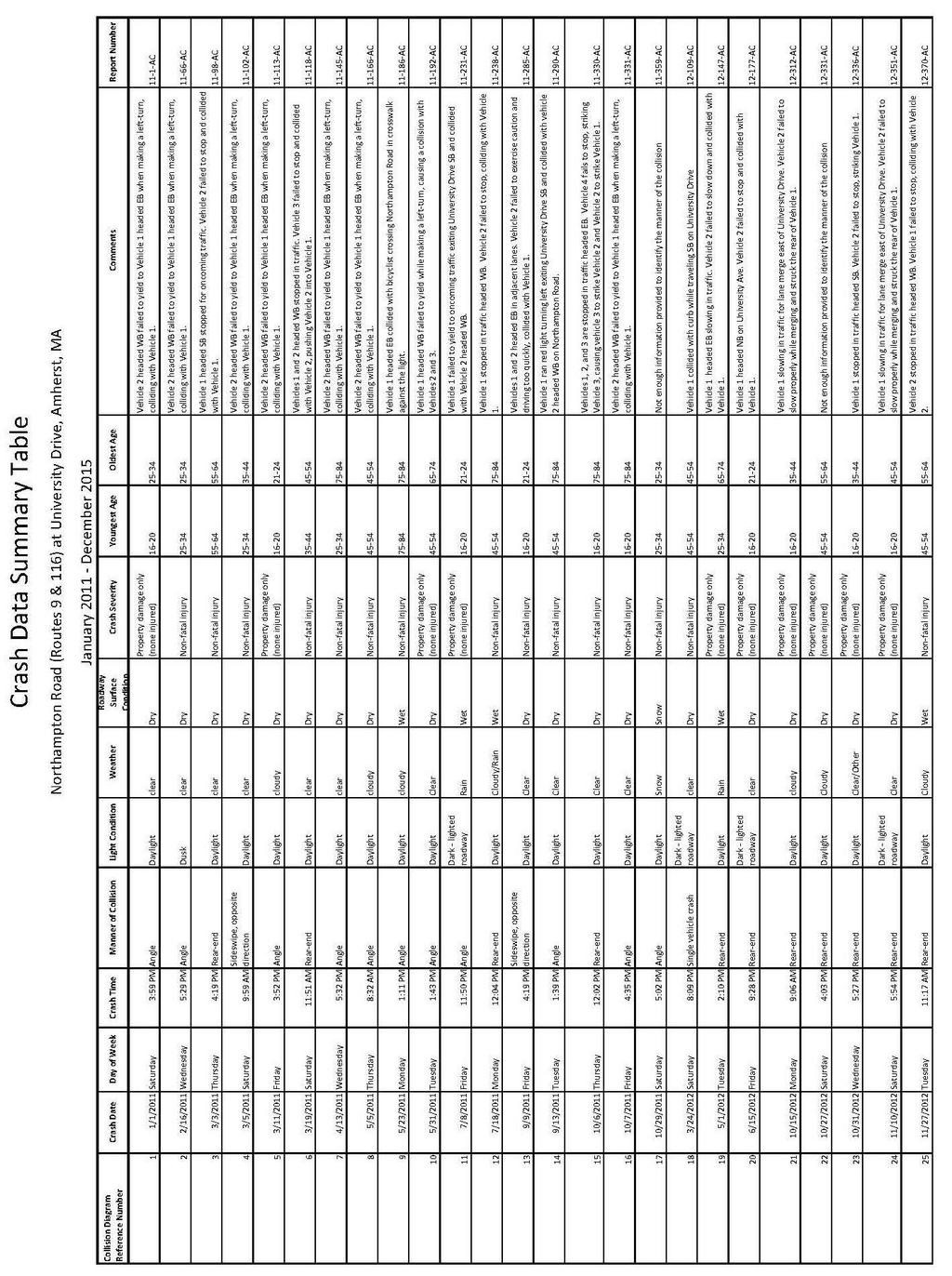
47
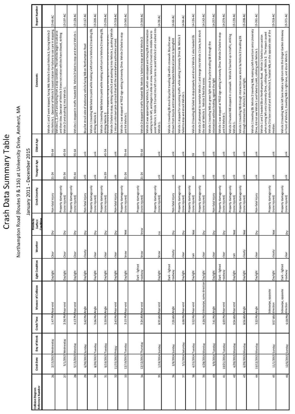
48
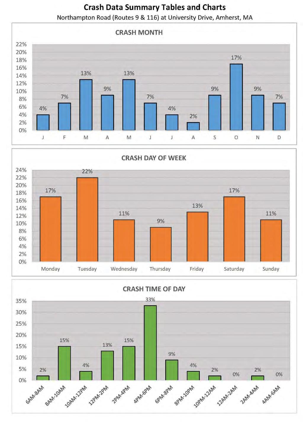
49
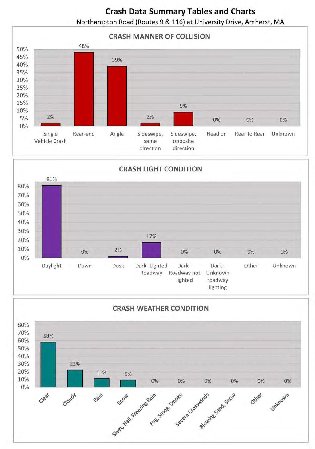
50
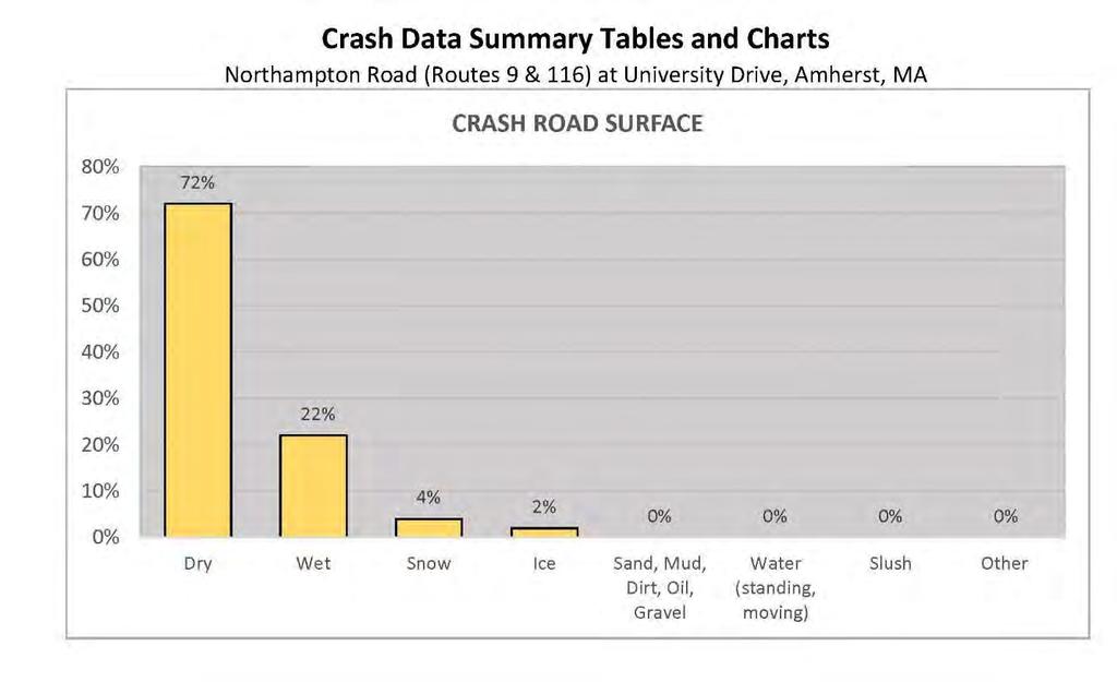
51
52 Appendix D. Additional Information
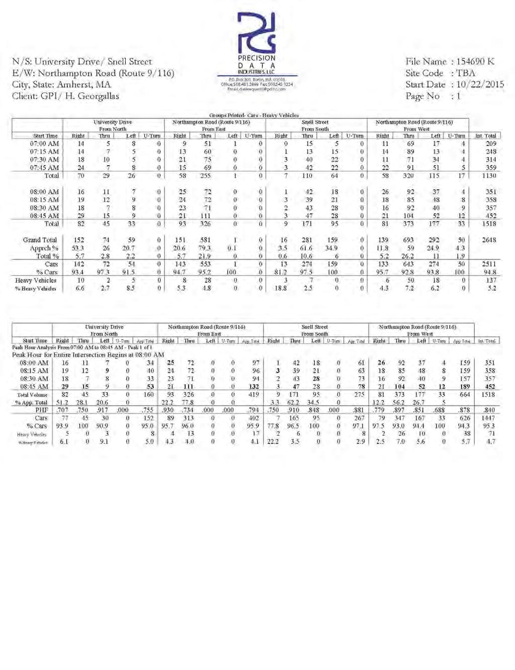
53
ROAD SAFETY AUDIT. May 18, Prepared For: MassDOT. On Behalf Of: Town of Milford
 ROAD SAFETY AUDIT East Main Street (Route 16) at Medway Road (Route 109), East Main Street (Route 16) at Quarry Square Driveways, East Main Street (Route 16) at Beaver Street/ Fortune Boulevard Town of
ROAD SAFETY AUDIT. State Road (Route 6) Corridor Town of Dartmouth. March Prepared For: MassDOT
 Corridor Town of Dartmouth. March Prepared For: MassDOT") ROAD SAFETY AUDIT State Road (Route 6) Corridor Town of Dartmouth March 2015 Prepared For: MassDOT Prepared By: McMahon Associates, Inc. 300 Myles Standish Blvd. Suite 201 Taunton, MA 02780 Table of Contents
ROAD SAFETY AUDIT State Road (Route 6) Corridor Town of Dartmouth March 2015 Prepared For: MassDOT Prepared By: McMahon Associates, Inc. 300 Myles Standish Blvd. Suite 201 Taunton, MA 02780 Table of Contents
ROAD SAFETY AUDIT. Blue Hill Avenue (Route 28) and Warren Street High Crash Locations City of Boston. November 1, 2016
 and Warren Street High Crash Locations City of Boston. November 1, 2016") ROAD SAFETY AUDIT Blue Hill Avenue (Route 28) and Warren Street High Crash Locations City of Boston November 1, 2016 Prepared For: MassDOT Highway Division Prepared By: BETA Group, Inc. Table of Contents
ROAD SAFETY AUDIT Blue Hill Avenue (Route 28) and Warren Street High Crash Locations City of Boston November 1, 2016 Prepared For: MassDOT Highway Division Prepared By: BETA Group, Inc. Table of Contents
ROAD SAFETY AUDIT. Russell Street (Route 9) at North and South Maple Streets Town of Hadley. March 2014
 at North and South Maple Streets Town of Hadley. March 2014") ROAD SAFETY AUDIT Russell Street (Route 9) at North and South Maple Streets Town of Hadley March 2014 Prepared for: Massachusetts Department of Transportation Prepared by: Howard/Stein-Hudson Associates
ROAD SAFETY AUDIT Russell Street (Route 9) at North and South Maple Streets Town of Hadley March 2014 Prepared for: Massachusetts Department of Transportation Prepared by: Howard/Stein-Hudson Associates
ROAD SAFETY AUDIT. Centre Street (Route 123) at Plymouth Street. Municipality of Brockton. November, Prepared For: MassDOT
 at Plymouth Street. Municipality of Brockton. November, Prepared For: MassDOT") ROAD SAFETY AUDIT Centre Street (Route 123) at Plymouth Street Municipality of Brockton November, 2017 Prepared For: MassDOT On Behalf Of: City of Brockton Prepared By: Old Colony Planning Council 70 School
ROAD SAFETY AUDIT Centre Street (Route 123) at Plymouth Street Municipality of Brockton November, 2017 Prepared For: MassDOT On Behalf Of: City of Brockton Prepared By: Old Colony Planning Council 70 School
ROAD SAFETY AUDIT. Granite Avenue at Interstate 93 Ramps. Town of Milton. May 22, Prepared for: MassDOT
 ROAD SAFETY AUDIT Granite Avenue at Interstate 93 Ramps Town of Milton May 22, 2017 Prepared for: MassDOT Prepared by: Toole Design Group 2 Oliver Street, Suite 305 Boston, MA 02109 Table of Contents Background...
AGENDA ITEM 6 D THOMASVILLE ROAD (HERMITAGE BOULEVARD TO LIVE OAK PLANTATION ROAD) ROADWAY SAFETY AUDIT
 ROADWAY SAFETY AUDIT") May 15, 2018 AGENDA ITEM 6 D THOMASVILLE ROAD (HERMITAGE BOULEVARD TO LIVE OAK PLANTATION ROAD) ROADWAY SAFETY AUDIT TYPE OF ITEM: Discussion STATEMENT OF ISSUE The Florida Department of Transportation
May 15, 2018 AGENDA ITEM 6 D THOMASVILLE ROAD (HERMITAGE BOULEVARD TO LIVE OAK PLANTATION ROAD) ROADWAY SAFETY AUDIT TYPE OF ITEM: Discussion STATEMENT OF ISSUE The Florida Department of Transportation
DEPARTMENT OF ENVIRONMENTAL SERVICES. North Harrison Street (Lee Highway to Little Falls Road) Comparative Analysis. Prepared for:
 Comparative Analysis. Prepared for:") DEPARTMENT OF ENVIRONMENTAL SERVICES North Harrison Street (Lee Highway to Little Falls Road) Comparative Analysis Prepared for: Arlington County Department of Environmental Services 2100 Clarendon Boulevard,
DEPARTMENT OF ENVIRONMENTAL SERVICES North Harrison Street (Lee Highway to Little Falls Road) Comparative Analysis Prepared for: Arlington County Department of Environmental Services 2100 Clarendon Boulevard,
Route 28 (South Orleans Road)/Route 39 (Harwich Road)/Quanset Road Intersection
/Route 39 (Harwich Road)/Quanset Road Intersection") TRAFFIC FEASIBILITY STUDY Route 28 (South Orleans Road)/Route 39 (Harwich Road)/Quanset Road Intersection Orleans, Massachusetts Prepared for: Town of Orleans Prepared by: Fay, Spofford & Thorndike, LLC
TRAFFIC FEASIBILITY STUDY Route 28 (South Orleans Road)/Route 39 (Harwich Road)/Quanset Road Intersection Orleans, Massachusetts Prepared for: Town of Orleans Prepared by: Fay, Spofford & Thorndike, LLC
ROAD SAFETY AUDIT. Route 202 (East State Street)/School Street & Route 202 (West State Street)/Pleasant Street/Amherst Street Town of Granby
/School Street & Route 202 (West State Street)/Pleasant Street/Amherst Street Town of Granby") ROAD SAFETY AUDIT Route 202 (East State Street)/School Street & Route 202 (West State Street)/Pleasant Street/Amherst Street Town of Granby March 2013 Prepared for: Massachusetts Department of Transportation
ROAD SAFETY AUDIT Route 202 (East State Street)/School Street & Route 202 (West State Street)/Pleasant Street/Amherst Street Town of Granby March 2013 Prepared for: Massachusetts Department of Transportation
MEMORANDUM. Date: 9/13/2016. Citywide Crosswalk Policy
 MEMORANDUM Date: 9/13/2016 Re: Citywide Crosswalk Policy Foreword Through the s Circulation Element and Complete Streets Policy, it is the City s goal to promote walking trips and provide safe facilities
ALLEY 24 TRAFFIC STUDY
 ALLEY 24 TRAFFIC STUDY in City of Frostburg, Maryland January 2013 3566 Teays Valley Road Hurricane, WV Office: (304) 397-5508 www.denniscorporation.com Alley 24 Traffic Study January 2013 Frostburg, Maryland
Draft North Industrial Area-Wide Traffic Plan
 Summary of North Industrial and Hudson Bay Industrial Recommended Improvements Table 1. Summary of s Item Location 1 2 3 4 5 6 7 8 9 10 11 12 Millar Ave north of 51st St Super 8 Motel back lane 400 Block
What Is a Complete Street?
 Session 5 Charleen Zimmer, AICP, Zan Associates May 5-7, 2010 What Is a Complete Street? May 2010 5-1 Not a Complete Street More of a Complete Street May 2010 5-2 Benefits of Complete Streets Safety for
ROAD SAFETY AUDIT. County Street at Hart Street. City of Taunton. January 30, Prepared For: Massachusetts Department of Transportation
 ROAD SAFETY AUDIT County Street at Hart Street City of Taunton January 30, 2015 Prepared For: Massachusetts Department of Transportation Prepared By: Toole Design Group 33 Broad Street, 4 th Floor Boston,
ROAD SAFETY AUDIT. Route 16 at Interstate 395 Town of Webster. October Prepared For: MassDOT
 ROAD SAFETY AUDIT Route 16 at Interstate 395 Town of Webster October 2015 Prepared For: MassDOT Prepared By: McMahon Associates, Inc. 300 Myles Standish Blvd. Suite 201 Taunton, MA 02780 Table of Contents
ROAD SAFETY AUDIT. Route 38 from Route 62 to Woburn Town Line. Town of Wilmington. April 10, Prepared For: MassDOT
 ROAD SAFETY AUDIT Route 38 from Route 62 to Woburn Town Line Town of Wilmington April 10, 2017 Prepared For: MassDOT Prepared By: Green International Affiliates, Inc. 239 Littleton Road, Suite 3, Westford,
PEDESTRIAN ACCOMMODATIONS DPS 201 AT INTERCHANGES
 PEDESTRIAN ACCOMMODATIONS DPS 201 AT INTERCHANGES UNDERSTANDING THE ISSUES Intersections of freeway ramp terminals at crossroads are the most critical components of an interchange Challenge: balance mobility
ROAD SAFETY AUDIT. Damon Road. City of Northampton. October Prepared for: Massachusetts Department of Transportation
 ROAD SAFETY AUDIT Damon Road City of Northampton October 2013 Prepared for: Massachusetts Department of Transportation Prepared by: Howard/Stein-Hudson Associates 38 Chauncy Street Boston, MA 02111 Table
ROAD SAFETY AUDIT. Plain Street (Route 139) at Furnace Street and Proprietors Drive Town of Marshfield. June 9, 2017.
 at Furnace Street and Proprietors Drive Town of Marshfield. June 9, 2017.") ROAD SAFETY AUDIT Plain Street (Route 139) at Furnace Street and Proprietors Drive Town of Marshfield June 9, 2017 Prepared for: MassDOT On Behalf of: Vanasse & Associates, Inc. 35 New England Business
ROAD SAFETY AUDIT Plain Street (Route 139) at Furnace Street and Proprietors Drive Town of Marshfield June 9, 2017 Prepared for: MassDOT On Behalf of: Vanasse & Associates, Inc. 35 New England Business
Date: April 4, Project #: Re: A Street/Binford Street Traffic/Intersection Assessment
 To: Peter Cavanaugh General Electric From: David Bohn, PE Ryan White, PE Date: April 4, 217 Project #: 13421. Re: / Traffic/Intersection Assessment Consistent with the Cooperation Agreement between the
Traffic Study of Fuller Street, Cady Street, West Street and West Avenue. Final Report
 Traffic Study of Fuller Street, Cady Street, West Street and West Avenue Final Report July 2005 Prepared for: Town of Ludlow Prepared by: Pioneer Valley Planning Commission 26 Central Street West Springfield,
M-58 HIGHWAY ACCESS MANAGEMENT STUDY Mullen Road to Bel-Ray Boulevard. Prepared for CITY OF BELTON. May 2016
 M-58 HIGHWAY ACCESS MANAGEMENT STUDY Prepared for CITY OF BELTON By May 2016 Introduction Missouri State Highway 58 (M-58 Highway) is a major commercial corridor in the City of Belton. As development has
Guidance. ATTACHMENT F: Draft Additional Pages for Bicycle Facility Design Toolkit Separated Bike Lanes: Two-Way to One-Way Transitions
 ATTACHMENT F: Draft Additional Pages for Bicycle Facility Design Toolkit Separated Bike Lanes: Two-Way to One-Way Transitions This treatment provides a transition from two-way separated bike lanes to one-way
Truck Turning Study for Main Street Intersection, Orange
 Truck Turning Study for Main Street Intersection, Orange Franklin Regional Council of Governments September 2015 0 Truck Turning Study for Main Street Intersection, Orange September 2015 Prepared by: Franklin
ROAD SAFETY AUDIT. Route 114 (Winthrop Av. And Parker St.) at Andover St. City of Lawrence. October 14, Prepared For: MassDOT
 at Andover St. City of Lawrence. October 14, Prepared For: MassDOT") ROAD SAFETY AUDIT Route 114 (Winthrop Av. And Parker St.) at Andover St. City of Lawrence October 14, 2011 Prepared For: MassDOT Prepared By: Merrimack Valley Planning Commission Road Safety Audit Route
ROAD SAFETY AUDIT Route 114 (Winthrop Av. And Parker St.) at Andover St. City of Lawrence October 14, 2011 Prepared For: MassDOT Prepared By: Merrimack Valley Planning Commission Road Safety Audit Route
Off-road Trails. Guidance
 Off-road Trails Off-road trails are shared use paths located on an independent alignment that provide two-way travel for people walking, bicycling, and other non-motorized users. Trails specifically along
ROAD SAFETY AUDIT. Boston Road (Route 20) at Parker Street and Pasco Road to Dumaine Street City of Springfield Town of Wilbraham.
 at Parker Street and Pasco Road to Dumaine Street City of Springfield Town of Wilbraham.") ROAD SAFETY AUDIT Boston Road (Route 2) at Parker Street and Pasco Road to Dumaine Street City of Springfield Town of Wilbraham October 4, 212 Prepared For: MassDOT Highway Division Prepared By: BETA Group,
ROAD SAFETY AUDIT Boston Road (Route 2) at Parker Street and Pasco Road to Dumaine Street City of Springfield Town of Wilbraham October 4, 212 Prepared For: MassDOT Highway Division Prepared By: BETA Group,
Pedestrian Road Safety Audit
 Pedestrian Road Safety Audit Middlebrook Road From Father Hurley Boulevard to Waring Station Road December 2017 Montgomery County Department of Transportation Table of Contents 1. Introduction... 1 1.1
Washington St. Corridor Study
 FIGURE 7.17 Bridge Alternatives - Cross Sections 86 Discarded Alternative: Short-Term Bridge Repair Short-term repairs and west bridge span replacement were considered during analysis. Short-term repairs
Military Road Safety Improvements
 Military Road Safety Improvements 26 th Road North to 31 st Street North SUMMARY OF DATA REVIEW AND PRELIMINARY RECOMMENDATIONS Prepared for: Department of Environmental Services Traffic Engineering and
Summary: Mercer County Princeton Avenue & Spruce Street Study January 2009
 Summary: Several recent studies have assessed potential development and redevelopment opportunities in the Mercer Crossing area of Trenton, Ewing, and Lawrence. This Princeton Avenue and Spruce Street
Caltrans Sloat Boulevard Pedestrian Safety Project Response to Community Questions, Comments & Concerns
 Caltrans Sloat Boulevard Pedestrian Safety Project Response to Community Questions, Comments & Concerns Revised: May 10, 2016 The California Department of Transportation (Caltrans) is planning various
Windy Ridge Elementary School
 Windy Ridge Elementary School SCHOOL ROUTE PLAN For WINDY RIDGE ELEMENTARY SCHOOL LOCATION 54 ORANGE COUNTY Prepared for: ORANGE COUNTY SCHOOL ASSESSMENT PROGRAM ORANGE COUNTY PUBLIC WORKS Traffic Engineering
Chapter 2: Standards for Access, Non-Motorized, and Transit
 Standards for Access, Non-Motorized, and Transit Chapter 2: Standards for Access, Non-Motorized, and Transit The Washtenaw County Access Management Plan was developed based on the analysis of existing
Active Transportation Facility Glossary
 Active Transportation Facility Glossary This document defines different active transportation facilities and suggests appropriate corridor types. Click on a facility type to jump to its definition. Bike
FLORIDA DEPARTMENT OF TRANSPORTATION DISTRICT 7 DISTRICT WIDE BICYCLE/PEDESTRIAN ACCESS TO TRANSIT SAFETY ASSESSMENT AND IMPROVEMENT PLAN
 FLORIDA DEPARTMENT OF TRANSPORTATION DISTRICT 7 DISTRICT WIDE BICYCLE/PEDESTRIAN ACCESS TO TRANSIT SAFETY ASSESSMENT AND IMPROVEMENT PLAN TRANSIT SAFETY ASSESSMENT SR 55/US 19 AT 80 TH AVE N DRAFT JUNE
ADA PRESENTATION (CURB RAMPS)
") ADA PRESENTATION (CURB RAMPS) ACECNJ/NJDOT/FHWA DESIGN SUMMIT Warren Howard New Jersey Department of Transportation May 21, 2013 ADA Curb Ramps NJDOT wants curb ramps to be designed & constructed properly
ADA PRESENTATION (CURB RAMPS) ACECNJ/NJDOT/FHWA DESIGN SUMMIT Warren Howard New Jersey Department of Transportation May 21, 2013 ADA Curb Ramps NJDOT wants curb ramps to be designed & constructed properly
BELCHERTOWN. Intersection of Federal Steet (Route 9) and Bay Road MAY 2012
 and Bay Road MAY 2012") BELCHERTOWN Intersection of Federal Steet (Route 9) and Bay Road MAY 2012 Prepared Under the Direction of Pioneer Valley MPO By: Pioneer Valley Planning Commission 60 Congress Street Springfield 01104-3419
BELCHERTOWN Intersection of Federal Steet (Route 9) and Bay Road MAY 2012 Prepared Under the Direction of Pioneer Valley MPO By: Pioneer Valley Planning Commission 60 Congress Street Springfield 01104-3419
Broad Street Bicycle Boulevard Design Guidelines
 Broad Street Bicycle Boulevard Design Guidelines Building from the strategies introduced in the 2013 Bicycle Transportation Plan and community input received thus far, City Transportation Staff have identified
Evaluation of M-99 (Broad Street) Road Diet and Intersection Operational Investigation
 Road Diet and Intersection Operational Investigation") Evaluation of M-99 (Broad Street) Road Diet and Intersection Operational Investigation City of Hillsdale, Hillsdale County, Michigan June 16, 2016 Final Report Prepared for City of Hillsdale 97 North Broad
Evaluation of M-99 (Broad Street) Road Diet and Intersection Operational Investigation City of Hillsdale, Hillsdale County, Michigan June 16, 2016 Final Report Prepared for City of Hillsdale 97 North Broad
ORANGE COUNTY PUBLIC WORKS TRAFFIC INVESTIGATIONS
 ORANGE COUNTY PUBLIC WORKS TRAFFIC INVESTIGATIONS STAFF REPORT OF: January 6, 2019 SUPERVISORIAL DISTRICT: 5 SUBJECT: LOCATION: INVESTIGATOR: O Neill Drive at Roanoke Drive; Ladera Ranch; TB 922-E6 Clever
Glenn Avenue Corridor Traffic Operational Evaluation
 Glenn Avenue Corridor Traffic Operational Evaluation PREPARED FOR: THE CITY OF AUBURN PREPARED BY: DECEMBER 2007 Glenn Avenue Corridor Study--Auburn, Alabama TABLE OF CONTENTS Introduction... 1 Background
ROAD SAFETY AUDIT. Needham Street and Highland Avenue Corridor. City of Newton and Town of Needham. March 2014
 ROAD SAFETY AUDIT Needham Street and Highland Avenue Corridor City of Newton and Town of Needham March 2014 Prepared for: Massachusetts Department of Transportation Prepared by: Howard/Stein-Hudson Associates
Existing Conditions. Date: April 16 th, Dan Holderness; Coralville City Engineer Scott Larson; Coralville Assistant City Engineer
 Date: April 16 th, 2015 To: From: Re: Dan Holderness; Coralville City Engineer Scott Larson; Coralville Assistant City Engineer Darian Nagle-Gamm, Traffic Engineering Planner Highway 6 (2 nd Street) /
Ottawa Beach Road Study
 Ottawa Beach Road Study Prepared For: Park Township September 30, 2014 Project No. G140303 OTTAWA BEACH ROAD STUDY PREPARED FOR: PARK TOWNSHIP SEPTEMBER 30, 2014 PROJECT NO. G140303 TABLE OF CONTENTS 1.0
MEMORANDUM. DATE March 1, 2012 TO Town of Milton Mark Abbott, Seth Asante, and Efi Pagitsas Boston Region MPO Staff
 MEMORANDUM DATE March 1, 212 TO Town of Milton FROM RE Mark Abbott, Seth Asante, and Efi Pagitsas Boston Region MPO Staff FFY 211 Safety and Operations Analyses at Selected Boston Region MPO Intersections:
ROAD SAFETY AUDIT. Route 114 at Interstate I-495 Northbound Ramps. City of Lawrence. July 30, 2015
 ROAD SAFETY AUDIT Route 114 at Interstate I-495 Northbound Ramps City of Lawrence July 30, 2015 Prepared For: Massachusetts Department of Transportation Prepared By: Toole Design Group 33 Broad Street,
ROAD SAFETY AUDIT MDM. Columbia Road at Dorchester Avenue. Dorchester, MA 10/14/2016. Prepared For: MassDOT. On Behalf Of: Edens
 ROAD SAFETY AUDIT Columbia Road at Dorchester Avenue Dorchester, MA 10/14/2016 Prepared For: MassDOT On Behalf Of: Edens Prepared By: MDM Transportation Consultants, Inc. 28 Lord Road Suite 280 Marlborough,
C/CAG. Sunnybrae Elementary School Walking and Bicycling Audit. San Mateo-Foster City School District JUNE 2013
 Sunnybrae Elementary School Walking and Bicycling Audit JUNE 2013 San Mateo-Foster City School District C/CAG City/County Association of Governments of San Mateo County SUNNYBRAE ELEMENTARY SCHOOL WALKING
MEMORANDUM. Layout Of Study Intersections And Traffic Control
 BOSTON REGION METROPOLITAN PLANNING ORGANIZATION Richard A. Davey, MassDOT Secretary and CEO and MPO Chairman Karl H. Quackenbush, Executive Director, MPO Staff DATE November 15, 2012 TO FROM RE Town of
APPENDIX A: Complete Streets Checklist DRAFT NOVEMBER 2016
 APPENDIX A: Complete Streets Checklist DRAFT NOVEMBER 2016 Complete Streets Checklist MetroPlan Orlando s Complete Streets Checklist is an internal planning tool for staff to further implementation of
A plan for improved motor vehicle access on Railroad Avenue in Provincetown
 A plan for improved motor vehicle access on Railroad Avenue in Provincetown February 2011 A plan for improved motor vehicle access on Railroad Avenue in Provincetown INTRODUCTION AND PROBLEM IDENTIFICATION
Cycle Track Design Best Practices Cycle Track Sections
 Design Best Practices Sections It is along street segments where the separation and protection methods of cycle tracks offer more comfort than conventional bicycle lanes, and are more attractive to a wide
ROAD SAFETY AUDIT. Route 3A from Evans Street to Abigail Adams State Park. Town of Weymouth. October 12, Prepared For: MassDOT
 ROAD SAFETY AUDIT Route 3A from Evans Street to Abigail Adams State Park Town of Weymouth October 12, 2016 Prepared For: MassDOT Prepared By: Green International Affiliates, Inc. 239 Littleton Road, Suite
Multi-Modal Traffic Analysis. Parisi and Associates
 Mill Valley to Corte Madera Bicycle and Pedestrian Corridor Study Appendix D: Multi-Modal Traffic Analysis Prepared by Parisi and Associates August 2009 Appendix D - Multi-Modal Traffic Analysis Table
ROAD SAFETY AUDIT. Providence Street (Route 122A) at McKeon Road/Millbury Street. City of Worcester. July 14, Prepared For: MassDOT
 at McKeon Road/Millbury Street. City of Worcester. July 14, Prepared For: MassDOT") ROAD SAFETY AUDIT Providence Street (Route 122A) at McKeon Road/Millbury Street City of Worcester July 14, 2016 Prepared For: MassDOT Prepared By: Stantec Consulting Services, Inc. Burlington, Massachusetts
ROAD SAFETY AUDIT Providence Street (Route 122A) at McKeon Road/Millbury Street City of Worcester July 14, 2016 Prepared For: MassDOT Prepared By: Stantec Consulting Services, Inc. Burlington, Massachusetts
ROAD SAFETY AUDIT. Mass Pike Interchange 6, I-291 and Burnett Road. City of Chicopee. November 4, Prepared For: MassDOT Highway Division
 ROAD SAFETY AUDIT Mass Pike Interchange 6, I-291 and Burnett Road City of Chicopee November 4, 2013 Prepared For: MassDOT Highway Division Prepared By: BETA Group, Inc. Table of Contents Project Data...
BENNING ROAD & BRIDGES TRANSPORTATION IMPROVEMENTS CRASH DATA AND SAFETY ANALYSIS TECHNICAL MEMORANDUM DRAFT MAY 2016
 BENNING ROAD & BRIDGES TRANSPORTATION IMPROVEMENTS CRASH DATA AND SAFETY ANALYSIS TECHNICAL MEMORANDUM DRAFT MAY 2016 This page left intentionally blank. Table of Contents 1.0 Introduction... 1 1.1 Crash
TRAFFIC ACCIDENT ANALYSIS
 TRAFFIC ACCIDENT ANALYSIS Westheimer at Chimney Rock and Westheimer at Dunvale Prepared for Prepared by Klotz Associates, Inc. 1160 Dairy Ashford, Suite 500 Houston, Texas 77079 The preparation of this
Appendix A: Crosswalk Policy
 Appendix A: Crosswalk Policy Appendix A: Crosswalk Policy Introduction This citywide Crosswalk Policy is aimed at improving pedestrian safety and enhancing pedestrian mobility by providing a framework
CAPE COD COMMISSION 3225 MAIN STREET P.O. BOX 226 BARNSTABLE, MA (508) Fax (508) Transportation Safety Report
 Fax (508) Transportation Safety Report") CAPE COD COMMISSION 3225 MAIN STREET P.O. BOX 226 BARNSTABLE, MA 02630 (508) 362-3828 Fax (508) 362-3136 2006 Transportation Safety Report Bourne: Otis Rotary Harwich: Route 137/Route 39 Orleans: Route
CAPE COD COMMISSION 3225 MAIN STREET P.O. BOX 226 BARNSTABLE, MA 02630 (508) 362-3828 Fax (508) 362-3136 2006 Transportation Safety Report Bourne: Otis Rotary Harwich: Route 137/Route 39 Orleans: Route
Figure 1: Vicinity Map of the Study Area
 ARIZONA TEXAS NEW MEXICO OKLAHOMA May 5, 2016 Mr. Anthony Beach, P.E. BSP Engineers 4800 Lakewood Drive, Suite 4 Waco, Texas 76710 Re: Intersection and Access Analysis along Business 190 in Copperas Cove
CITY OF WEST LAKE HILLS. Forest View Neighborhood Traffic Calming Study
 CITY OF WEST LAKE HILLS 901 South Mopac Expressway Building V, Suite 220 Austin, Texas 78746 Texas P.E. Firm Registration No. F-929 Klotz Associates Final Report Submittal: March 20, 2015 Revised Final
Gateway Transportation Study
 Gateway Transportation Study Amherst, Massachusetts SUBMITTED TO University of Massachusetts Amherst Town of Amherst SUBMITTED BY Vanasse Hangen Brustlin, Inc. Watertown, Massachusetts March 213 Back of
Hidden Oaks Elementary School
 Hidden Oaks Elementary School SCHOOL ROUTE PLAN For HIDDEN OAKS ELEMENTARY SCHOOL LOCATION 13 ORANGE COUNTY Prepared for: ORANGE COUNTY SCHOOL ASSESSMENT PROGRAM ORANGE COUNTY PUBLIC WORKS Traffic Engineering
Pedestrians and Bicyclists. Bruce Friedman and Scott Wainwright FHWA MUTCD Team
 Impact of the New MUTCD on Pedestrians and Bicyclists Bruce Friedman and Scott Wainwright FHWA MUTCD Team Development of the 2009 MUTCD NPA published in the Federal Register on January 2, 2008 Received
TRAFFIC ACTION PLAN. Laurie Meadows Neighborhood CITY OF SAN MATEO
 TRAFFIC ACTION PLAN Laurie Meadows Neighborhood CITY OF SAN MATEO Draft January 2017 Table of Contents Introduction... 2 The Traffic Forum Process... 5 Neighborhood Traffic Issues... 7 Neighborhood Recommendations
METHODOLOGY. Signalized Intersection Average Control Delay (sec/veh)
") Chapter 5 Traffic Analysis 5.1 SUMMARY US /West 6 th Street assumes a unique role in the Lawrence Douglas County transportation system. This principal arterial street currently conveys commuter traffic
Chapter 5 Traffic Analysis 5.1 SUMMARY US /West 6 th Street assumes a unique role in the Lawrence Douglas County transportation system. This principal arterial street currently conveys commuter traffic
ROAD SAFETY AUDIT. Rourke Bridge at Pawtucket Boulevard (Route 113) City of Lowell. October 5, Prepared For: MassDOT.
 City of Lowell. October 5, Prepared For: MassDOT.") ROAD SAFETY AUDIT Rourke Bridge at Pawtucket Boulevard (Route 113) City of Lowell October, 2017 Prepared For: MassDOT Prepared By: Vanasse Hangen Brustlin, Inc 101 Walnut Street Watertown, MA 02472 Road
ROAD SAFETY AUDIT Rourke Bridge at Pawtucket Boulevard (Route 113) City of Lowell October, 2017 Prepared For: MassDOT Prepared By: Vanasse Hangen Brustlin, Inc 101 Walnut Street Watertown, MA 02472 Road
ROAD SAFETY AUDIT. South Street (Route 1A) at East Bacon Street (Route 106) and West Bacon Street Town of Plainville.
 at East Bacon Street (Route 106) and West Bacon Street Town of Plainville.") ROAD SAFETY AUDIT South Street (Route 1A) at East Bacon Street (Route 106) and West Bacon Street Town of Plainville March 15, 2018 Prepared For: MassDOT On Behalf Of: Town of Plainville Prepared By: BETA
ROAD SAFETY AUDIT South Street (Route 1A) at East Bacon Street (Route 106) and West Bacon Street Town of Plainville March 15, 2018 Prepared For: MassDOT On Behalf Of: Town of Plainville Prepared By: BETA
INTERSECTION DESIGN TREATMENTS
 Designing for Bicyclist Safety INTERSECTION DESIGN TREATMENTS LEARNING OUTCOMES Understand intersection design options and features Select appropriate design feature for a bikeway in a given context C1
Meadow Woods Elementary School
 Drag and drop pic and stretch/crop to the limits of the blue rectangle (delete this text box) Meadow Woods Elementary School Drag and drop pic and stretch/crop to the limits of the blue rectangle (delete
City of Vallejo Traffic Calming Toolbox
 City of Vallejo Traffic Calming Toolbox June 1, 2013 Final Table of Contents Introduction... 1 Non-Physical Devices... 3 High-Visibility Crosswalk... 3 In Pavement Lighted Crosswalk... 4 Rapid Flashing
PEDESTRIAN SAFETY STUDY
 PEDESTRIAN SAFETY STUDY SR 699 (BLIND PASS RD/GULF BLVD) FROM 93 RD AVENUE TO PINELLAS BAYWAY PINELLAS COUNTY SECTION NO.: 15100 MILEPOST: 0.111 3.569 STUDY LIMITS Prepared For: Florida Department of Transportation
MEMORANDUM. Charlotte Fleetwood, Transportation Planner
 MEMORANDUM Date: Updated August 22, 2017 To: Organization: Charlotte Fleetwood, Transportation Planner Boston Transportation Department From: Jason DeGray, P.E., PTOE, Regional Director of Engineering
Appendix T CCMP TRAIL TRAFFIC & TRANSPORTATION DESIGN STANDARD
 Appendix T CCMP 3.3.4 TRAIL TRAFFIC & TRANSPORTATION DESIGN STANDARD 3.3.4 Trail Traffic and Transportation Design Multi-use trails have certain design standards, which vary depending on the agency that
ROAD SAFETY AUDIT. Marston s Corner Route 113 at Jackson and Howe Sts. City of Methuen. February 14, 2014
 ROAD SAFETY AUDIT Marston s Corner Route 113 at Jackson and Howe Sts. City of Methuen February 14, 2014 Prepared For: Merrimack Valley Metropolitan Planning Organization Prepared By: Merrimack Valley Planning
5. RUNNINGWAY GUIDELINES
 5. RUNNINGWAY GUIDELINES These guidelines should be considered collectively when making runningway decisions. A runningway is the linear component of the transit system that forms the right-of-way reserved
Bay to Bay Boulevard Complete Streets Project
 Bay to Bay Boulevard Complete Streets Project Dale Mabry Highway to Bayshore Boulevard February 08, 2018 Photo Source: Tampa Bay Times Alessandra Da Pra Meeting Format Introduction Resurfacing Information
ROAD SAFETY AUDIT. Santilli Circle and Sweetser Circle. Municipality of Everett. March 10, Prepared For: MassDOT
 ROAD SAFETY AUDIT Santilli Circle and Sweetser Circle Municipality of Everett Prepared For: MassDOT On Behalf Of: WYNN Design and Development Prepared By: AECOM 250 Apollo Drive Chelmsford, MA Road Safety
Lake Whitney Elementary School
 Lake Whitney Elementary School SCHOOL ROUTE PLAN For LAKE WHITNEY ELEMENTARY SCHOOL LOCATION 18 ORANGE COUNTY Prepared for: ORANGE COUNTY SCHOOL ASSESSMENT PROGRAM ORANGE COUNTY PUBLIC WORKS Traffic Engineering
CITY OF OTTAWA ROADWAY MODIFICATION APPROVAL UNDER DELEGATED AUTHORITY
 RMA-2015-ATM-038 CITY OF OTTAWA ROADWAY MODIFICATION APPROVAL UNDER DELEGATED AUTHORITY DATE: April 22, 2015 SUBJECT Approval of Roadway Modifications Recommended through an Area Traffic Management Study
Improving Cyclist Safety at the Dundas Street West and Sterling Road Intersection
 STAFF REPORT ACTION REQUIRED Improving Cyclist Safety at the Dundas Street West and Sterling Road Intersection Date: August 17, 2012 To: From: Wards: Reference Number: Public Works and Infrastructure Committee
City of Scotts Valley CITY COUNCIL STAFF REPORT
 DATE: April 19, 2017 City of Scotts Valley CITY COUNCIL STAFF REPORT AGENDA ITEM 2 DATE: 4-19-2017 TO: FROM: APPROVED: SUBJECT: Honorable Mayor and City Council Scott Hamby, Public Works Director Jenny
Appendix D: Concept Screening
 Concept Description Concept #1 Route 288 Roadway Widening This concept consists of constructing a third lane on northbound and southbound Route 288 between Powhite Parkway and US 360. This improvement
Traffic Circulation & Pedestrian Safety Study
 Lyons Township High School North Campus La Grange, Illinois Parking Lot Vaughan Building N Main Building Prepared for: Prepared by: July 23, 2015 Contents List of Figures, iii 1. Introduction...1 2. Existing
Memorandum. Sunday, July 13, Saturday, July 19, 2014
 Memorandum To: David Lowin, Brooklyn Bridge Park Corporation From: Daniel Schack, AICP, PTP Date: Re: Brooklyn Bridge Park Pier 5/6 Loop Road Traffic Study Project No: 14-01-2407 At the request of Brooklyn
Downtown Traffic Study
 City of Lynn Massachusetts Downtown Traffic Study March 2005 315 Norwood Park South, Norwood, MA 02062 781.255.1982 email: beta@beta-inc.com LYNN DOWNTOWN TRAFFIC STUDY INTRODUCTION The City of Lynn is
ROAD SAFETY AUDIT. Route 113 (Storey Avenue) at Woodman Way and Low Street. Newburyport, MA. May 27, Prepared For: MassDOT
 at Woodman Way and Low Street. Newburyport, MA. May 27, Prepared For: MassDOT") ROAD SAFETY AUDIT Route 113 (Storey Avenue) at Woodman Way and Low Street Newburyport, MA May 27, 2015 Prepared For: MassDOT Prepared By: Bayside Engineering, Inc. 600 Unicorn Park Drive Woburn, MA 01801
ROAD SAFETY AUDIT Route 113 (Storey Avenue) at Woodman Way and Low Street Newburyport, MA May 27, 2015 Prepared For: MassDOT Prepared By: Bayside Engineering, Inc. 600 Unicorn Park Drive Woburn, MA 01801
City of Prince Albert Statement of POLICY and PROCEDURE. Department: Public Works Policy No. 66. Section: Transportation Issued: July 14, 2014
 Page: 1 of 8 1 POLICY 1.01 The City shall follow all of the specifications in the Manual of Uniform Traffic Control Devices for Canada, prepared by the National Committee of Uniform Traffic Control, and
BOSTON REGION METROPOLITAN PLANNING ORGANIZATION
 PLANNING ORGANIZATIO BOSTON REGION MPO NMETROPOLITAN BOSTON REGION METROPOLITAN PLANNING ORGANIZATION Stephanie Pollack, MassDOT Secretary and CEO and MPO Chair Karl H. Quackenbush, Executive Director,
Orange Center Elementary School
 Drag and drop pic and stretch/crop to the limits of the blue rectangle (delete this text box) Orange Center Elementary School Drag and drop pic and stretch/crop to the limits of the blue rectangle (delete
March 11, Lynnfield Board of Selectmen Town of Lynnfield 55 Summer Street Lynnfield, MA Walnut Street Traffic Assessment
 March 11, 2015 Lynnfield Board of Selectmen Town of Lynnfield 55 Summer Street Lynnfield, MA 01940 Re: Walnut Street Traffic Assessment Dear Board of Selectmen Members: As requested, BETA Group, Inc. (BETA)
MUTCD Part 6G: Type of Temporary Traffic Control Zone Activities
 MUTCD Part 6G: Type of Temporary Traffic Control Zone Activities 6G.01 Typical Applications Each temporary traffic control (TTC) zone is different. Many variables, such as location of work, highway type,
MEMORANDUM. Nantasket Road at Kingsley Road Kingsley Road at Sumner Street Kingsley Road at Revere Street Kingsley Road at Kenberma Street
 MEMORANDUM Date: June 28, 2012 To: From: Subject: Mr. Joseph Stigliani, Director of Public Works Kenneth J. Petraglia, P.E., PTOE Greg E. Lucas, P.E., PTOE Kingsley Road Stop Sign Warrant Analysis BETA
Agenda. Overview PRINCE GEORGE S PLAZA METRO AREA PEDESTRIAN PLAN
 PRINCE GEORGE S PLAZA METRO AREA PEDESTRIAN PLAN May 28, 2008 Agenda Welcome and introductions Project overview and issue identification Planning context and strengths Design challenges and initial recommendations
A Sample Report of TRAFFIC CONTROL DEVICES REVIEW
 A Sample Report of TRAFFIC CONTROL DEVICES REVIEW Introduction We performed a peer review of traffic control devices at selected locations on the City s street system. As the result of our review, we have
City of Albert Lea Policy and Procedure Manual 4.10 ALBERT LEA CROSSWALK POLICY
 4.10 ALBERT LEA CROSSWALK POLICY PURPOSE: Pedestrian crosswalks are an integral part of our transportation infrastructure. To be effective and promote safety, marked crosswalks must be installed after
Developed by: The American Traffic Safety Services Association (ATSSA) 15 Riverside Parkway, Suite 100 Fredericksburg, VA
 15 Riverside Parkway, Suite 100 Fredericksburg, VA") Addendum Developed by: The American Traffic Safety Services Association (ATSSA) 15 Riverside Parkway, Suite 100 Fredericksburg, VA 22406-1022 800-272-8772 This material is based upon work supported by
Addendum Developed by: The American Traffic Safety Services Association (ATSSA) 15 Riverside Parkway, Suite 100 Fredericksburg, VA 22406-1022 800-272-8772 This material is based upon work supported by