West Somerset Coast Path Text
|
|
|
- Elisabeth Eaton
- 6 years ago
- Views:
Transcription

1 West Somerset Coast Path Text Section Area 1 Steart to Stolford 2 Stolford to Lilstock 3 Lilstock to Kilve 4 Kilve to A39 Road Crossing 5 A39 Road Crossing to West Quantoxhead 6 West Quantoxhead to A39 at Highbridge, Wlliton 7 A39 at Highbridge, Williton to Watchet Harbour 8 Watchet Harbour to Blue Anchor 9 Blue Anchor to Dunster Beach 10 Dunster Beach to Minehead

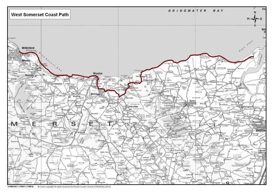
2 INTRODUCTION The West Somerset Coast Path runs from the hamlet of Steart to the coastal resort of Minehead and passes through the Quantock Hills Area of Outstanding Natural Beauty (AONB). The Coast Path links the River Parrett Trail to the South West Coast Path National Trail. The path also joins the Coleridge Way and Quantock Greenway just south of the A39 near East Quantoxhead. The coast path is approximately 25 miles in length. There are magnificent seaward and inland views with occasional glimpses of industrial archaeology and a wealth of geology. The route is described heading west from Steart to Minehead. You can join the path at a number of locations allowing you to choose the length of your walk. In addition, there are a number of circular walks adjacent to the main route as well as access to towns and villages at Kilve, West Quantoxhead, Williton, Watchet, Blue Anchor, Dunster and Minehead. These offer a range of services and facilities such as shops, pubs, cafes, restaurants, hotels and B&Bs. The route has been developed with the kind co-operation of a large number of landowners and farmers along the route. Without their help and support many of the links in this path chain would not have been possible. To make the most of your walk, dress to suit the season and wear stout shoes or boots. Please keep away from cliff edges and only go on to beaches where it is possible using public footpaths or a permissive access. Take care when crossing or using sections of road. Please keep dogs under close control near livestock at all times. Look out for the distinctive ammonite posts and way-marker discs to help you follow the trail.
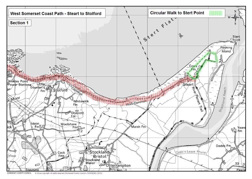
3 SECTION 1 - STEART TO STOLFORD 2.9 miles From the car park near Dowell s Farm turn right at the car park gate. Walk for about one mile along the road until arriving at a fairly sharp left bend. Look for the ammonite post on the right and pass between the large rocks. Follow the broad track ahead. On the beach there are the remains of a quadrant hut that was used to determine the accuracy of bomb strikes when the area was a range during the last century. Although no bombs have been found for a long time, local children were once able to collect small shell cases for scrap metal. Looking back inland to the southeast you may spot the World War II barrage balloon hanger on the Pawlett Hams. This is a large rounded building rather like a huge barn. As you continue along the track you are crossing firstly Wall Common and then Catsford Common grazed by sheep belonging to those who still enjoy Commoner s rights. When you reach the small hamlet of Stolford the track converges with the sea wall and defence. Exposed just out at sea is the site of a submerged fossilised forest and rocky outcrops, showing us why shipping needs to take care navigating along this coastline. Looking northeast up the Bristol Channel you can see the two islands of Steep Holm, and if light is favourable, Flat Holm beyond. Steep Holm is rich in military history and has evidence of occupation through many periods including Roman and Viking, and is also rich in flora and fauna. You can visit the island by charter launch from Weston-super-Mare, or in the summer, by one of the steam vessels sailing from Minehead.
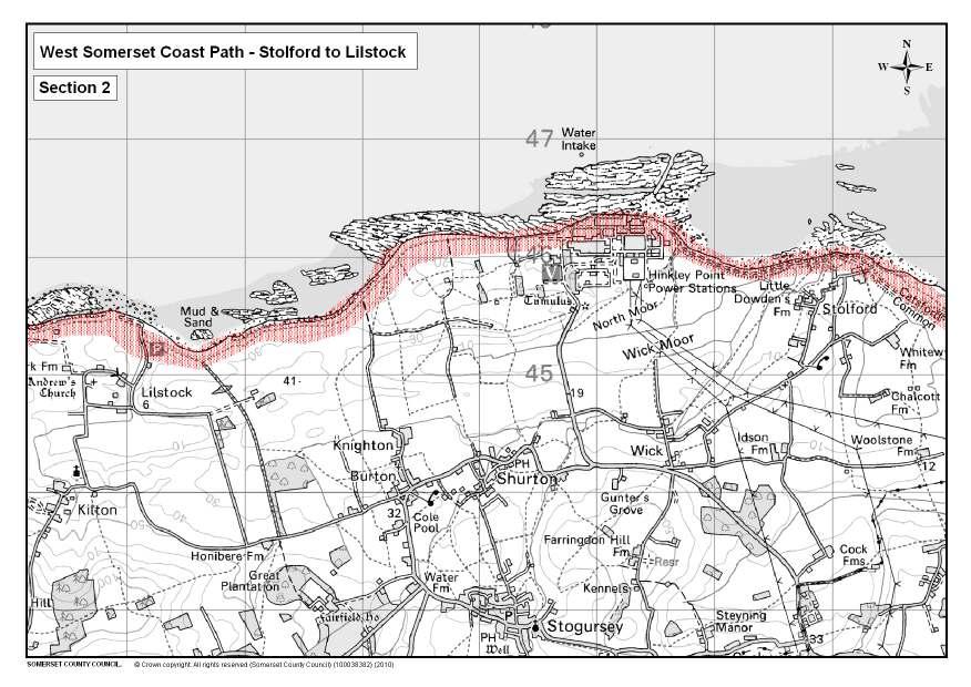
4 SECTION 2 - STOLFORD TO LILSTOCK 4.1 miles Stolford is easily accessed by road by following sign-posts to Hinkley Point power station from the A39. There is car parking for those who want an out and back walk between Stolford and Lilstock. Leaving Stolford follow the broad track ahead and pass through a narrow gate beside a field gate. Ignore the footpaths to your left. You will see objects that look like old-fashioned lampshades hanging from poles in the field. These monitor the air quality in the area. As you approach Hinkley Point Power Station pass through a gate within a gate. The track is now edged on both sides by small woodlands, predominately alder with some willow. As you leave the wooded area, the path bears to the right. A large number of notices remind you that you are in a licensed nuclear power generating site. Continue on the path with a fence to your left and a sea defence wall to the right. For almost three-quarters of a mile you can see over the wall and at low tide, flat pavements and blocks of limestone are visible. The shore contains evidence of giant marine reptiles, whole ichthyosaur skeletons and large ammonites have been found. Also local people have uncovered the remains of elk antlers and wild boar tusks. Fossilised oak and yew tree sections are still visible in places. On your left is a huge wall made up of rock-filled baskets. Out at sea is the caisson providing cooling water for the generating process. This is a popular shoreline area with fishermen who catch mainly cod but also some bass and flounder. A solid concrete footway now takes you to the end of the Hinkley Point site. Even on this unnatural base, nature is colonising with a fine display of rock sea lavender finding a niche to survive. Ignoring the stile to your left follow the grass path. This grass area is one of the few remaining semi-natural grasslands along the coastline supporting species such as bee and pyramidal orchids, carline thistle, thyme and adder s tongue fern. After approximately three-quarters of a mile, the fence ends and an information board tells you about the area. At an ammonite post, situated by a huge screen of brambles and scrub, follow the path to Lilstock down onto the pebble shore. Go through a gap to your left, through a kissing gate and turn right to walk along the broad headland path, with brambles and rising cliffs to your right. Far in the distance you can now see the distinctive shape of North Hill above Minehead. Unless you intend to undertake a circular walk, using the numerous permissive paths, continue straight ahead and soon you will see below you on the foreshore the straight pavements of limestone become swirling formations.
5 Walk straight on until faced by a third hedgerow. In the right-hand corner you will find a kissing gate, go through it and walk ahead with a wire fence to your right. Soon you will come across a mound and clump of elderly thorn trees. Keep right and walk on down to another gate within a gate. Pass through the gate and then turn right towards the beach at Lilstock. The banked depression to your right as you arrive is what remains of Lilstock Harbour. The rectangular depression provided berthing facilities for small vessels. Coal, wheat and limestone were imported and exported making the site a bustling port. Old photographs also show houses built close under the cliffs on the quayside. A pier provided moorings for the Victorian pleasure steamers which travelled along this stretch of coast. From your point of arrival turn left and leave for Kilve.
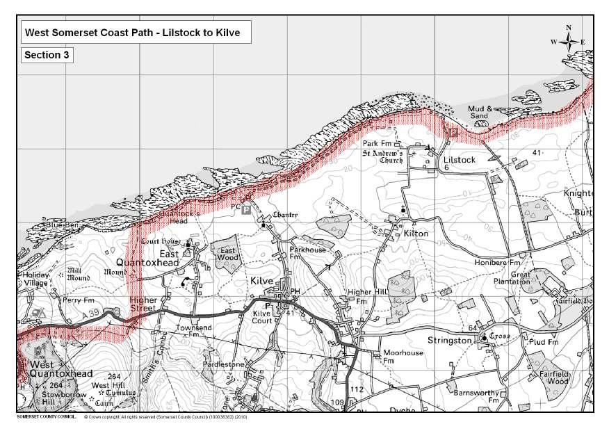
6 SECTION 3 - LILSTOCK TO KILVE 1.9 miles Lilstock is accessible by car and parking is available. Follow road signs between Holford and Kilve on the A39. The broad track passes Lilstock outfall on your left, suggesting that the fields immediately inland are again low-lying. Shortly afterwards you will see a World War II look-out bunker, discreetly placed to give an early warning of any enemy activity in the Channel. Continue on the broad headland track to a kissing gate. Out at sea you will see a number of yellow cones. These demarcate target zones for the military aircraft crews practising their strike skills. In the spring these cliff edges are covered with cowslips. Inland the undulating farmland rises up to the Quantock Hills. This area marks the boundary of the Quantock Hills Area of Outstanding Natural Beauty that was designated in 1956 as England s first AONB. Looking along the skyline from left to right you will see the hills above the villages of Nether Stowey and Holford, Both villages have close associations with the poets Coleridge and Wordsworth. Moving on you will arrive at the Royal Navy lookout tower. Carry straight on ahead, dropping downhill. If the tide is out you can see further examples of the limestone formations on the foreshore. Watchet can be seen in the distance. Away to the left, on the western skyline, the highest point in Somerset, Dunkery Beacon on Exmoor, may be visible. The path to Kilve ends on a flat, grass area and just ahead is a stream running through a reed bed into the sea. Do not cross it, but turn left and head inland on a broad track with the remains of a limekiln to the right, sheltered by thorn bushes. This area, now a Site of Special Scientific Interest, is the remains of a medieval harbour and is known as Kilve Pill. A short distance further on brings you to a red brick building with a distinctive chimneystack (the Oil Retort). Of great interest to the industrial archaeologist, it was part of the oil retort system built in the early part of the 20th Century. The coast at Kilve is rich in oil-bearing shale and large sums of money were invested in a hoped-for oil boom. Both interest and returns faded and the venture was abandoned. Public toilets are available near the car park at Kilve Beach. If you feel like some refreshments, walk up the road past the grass car park on your right, to a Tea Shop near the remains of a 15th Century Chantry. Chantries were specifically used for the saying of masses for the dead. The building fell into ruin after the Reformation in the 16th century and the ruins themselves were destroyed by fire in Kilve Parish Church of St Mary the Virgin, which is close-by, has a fine Saxon font. The Hood Arms and the village store are further on up the lane, past the church, on the A39, approximately ¾ of a mile from the path.
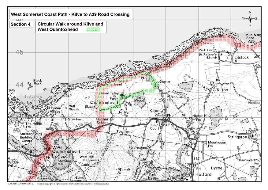
7 SECTION 4 - KILVE TO A39 ROAD CROSSING 1.8 miles If you have left the Coast Path to enjoy refreshments in Kilve, return to the old oil retort, near which is an Information board. Pass through the access gateway to follow the tarmac surfaced path that climbs gently to a gate. There are benches close by and a picnic table at the end of an easy access trail to the beach so you have the chance to sit and view the Bristol Channel. Beyond the gate continue along the broad headland path which again gives magnificent views of the Quantock Hills as you look inland, the Welsh coast to the north, and northeast up the Bristol Channel. Adjacent fields are sometimes grazed by fine examples of pedigree Hereford cattle. The large country house inland to the south west is Court House at East Quantoxhead, home of the Luttrell family since the Norman Conquest, attached to which is the church of St Mary the Virgin. The headland path ends with a left turn at a lime kiln; here you can make a detour to visit the small hamlet of East Quantoxhead with its church and mill pond or go down some metal steps to your right to look at the foreshore and its geology. If you have taken the detour return to the limekiln and follow the direction indicated by the finger post to a kissing gate with a notice informing you that you are next using a permissive path, enclosed by a fence. The path climbs to a high point (Quantock s Head) then levels to approach a second kissing gate. Go through the gate and turn left to head south on a broad field edge path. The land falls away on your right. Continue straight ahead. On the right are the remains of a medieval windmill site. Do not turn left at an obvious path junction but climb steadily straight ahead to arrive at a kissing gate on the side of the main A39 road.
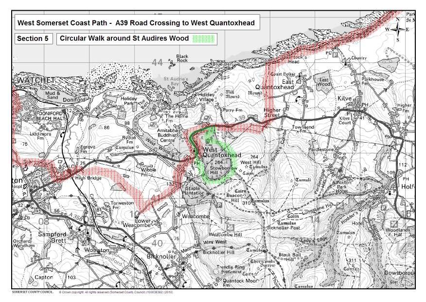
8 SECTION 5 - A39 ROAD CROSSING TO WEST QUANTOXHEAD 1.7 miles MOTORISTS ARE WARNED TO EXPECT PEDESTRIANS BUT PLEASE TAKE EXTREME CARE WHEN CROSSING THE A39. Having arrived at the top of the field, marked by a kissing gate, cross the road with care. Pass through a second kissing gate and walk within an enclosed path for a short distance to join a fairly broad track. Turn left and walk up past the cottages on your left into a narrow enclosed lane, running uphill, to a gate where you are met by a choice of two bridle paths. This is where the Coast Path meets the Coleridge Way and the Quantock Greenway. Take the path to your right. Follow it along a hedge bank, occasionally topped with a fence-line to deter deer entering the pasture. You are at the northern end of a block of common land that rises fairly steeply to your left. Red deer lie up in the bracken on this hill known as West Hill. Walk on until the path drops steeply down to some steps with a handrail. Ignore the bridle path and Quantock Greenway signs that go off to the left. Carry on straight ahead to a permissive path, keeping well away from the fence line and quarry edge. Pass through a kissing gate and then follow the forest track round, keeping the road on your right, for about a mile. As the path climbs you will find a seat at the highest point with wonderful open views of St Audries, Exmoor and Minehead. Continue along the path and keep the cast iron fence on your right. This was erected in the last century when the area formed part of the Deer Park for St Audries house and held large numbers of fallow and red deer. For a short time the two parcels of land were also connected by a bridge that crossed over the A39, but this was demolished in When you reach a gate, turn right, walking down the slope to meet a tarmac road. Walk down until you come to a gap on your left, just before the main road. Go through this gap onto the enclosed section of path until you exit onto the car park at the Windmill pub.
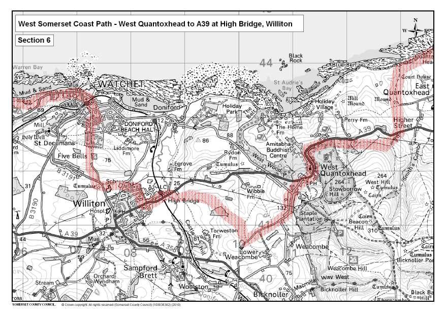
9 SECTION 6 - WEST QUANTOXHEAD TO A39 AT HIGH BRIDGE, WILLITON 2.2 miles Continue across the car park to the front of the Windmill pub then turn left at the Quantock Greenway signpost and follow the road into the village of West Quantoxhead. Carry on along the road (The Avenue) for about a mile arriving at a road junction beyond the national speed limit road sign. Go straight ahead into Luckes Lane. Ignore the first signposted field gate on your right and proceed for about half a mile to the next signed path on your right with a stile alongside the gate. Go over the stile and follow the field edge path on your right to meet two pedestrian gates. Ignore the right hand gate and go through the one straight ahead. Follow the enclosed path with a hedge on the left and fence on right. There is a woodland to the left and once again the sea comes into view in the distance. The enclosed path goes through three gates before reaching an open field. Turn right to a stile and on to the verge alongside the A39 at High Bridge, on the outskirts of Williton. WEST SOMERSET RAILWAY West Somerset Railway is Britain s longest preserved railway and runs for 20 miles between Bishops Lydeard and Minehead. The railway recaptures the era of the branch line country railway in the days of steam. There are 10 restored stations along the route, each having its own charm and character. Many have signalboxes, engine sheds, museums and steam engines. Stations along the way where you can join the train include Williton, Doniford Halt, Watchet, Blue Anchor, Dunster and Minehead. Trains run regularly throughout the year.
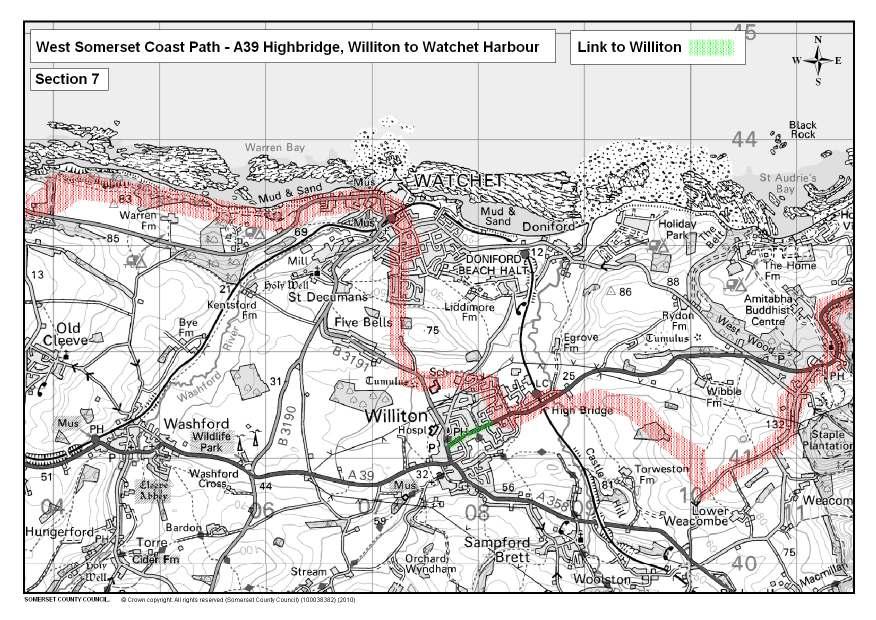
10 SECTION 7 - A39 HIGHBRIDGE, WILLITON TO WATCHET HARBOUR 2.2 miles Cross the main road with care and almost straight away turn into Highbridge and follow the lane over the Doniford Brook to the railway crossing at Williton station. Williton is the first place on the route where you can take the West Somerset Steam Railway. Pass over the lines and walk straight ahead along Station Road ignoring any turnings to your right until reaching the main A39 at Long Street. Turn into Long Street and continue along the pavement for a short distance until you come to a lane on your right (just prior to the old hospital site with the green wrought iron railings). Turn right into the lane and follow it along its length, turn left and proceed along this path which runs to the back of the houses until you come to a kissing gate. Go through the kissing gate and continue along the path until you join another path. Turn right and follow this path all the way to the end, you will cross a narrow stone bridge before joining the road. Cross the road, turn left and walk along the road for a short distance and on the right is a stile leading into a field. Cross the stile and follow the field edge path which eventually becomes a wide grassy path hedged on both sides. Continue straight ahead until you come to the road. Turn right and walk along the pavement until you come to a metalled path with lampposts. Turn right into the path and follow it all the way up over the hill until you come to a gate. Go through the gate, turn left then right and you will come to the road. Turn right then immediately left into Woodland Road and walk along the road until you come to Flowerdale Road. Turn right into Flowerdale Road and follow it to the end. Turn left into Liddymore Road and continue until you arrive at the main road. Cross the main road with care and go straight ahead into Goviers Lane. Continue down Goviers Lane to the bottom, over the railway line, down the steps and go straight across the road and proceed along The Esplanade. As you pass the first white barrier look over the wall to see a fine pebble mosaic. The name Watchet has been given to a piece of cloth of a particular shade of blue. Whether or not the blue came from the dye of locally picked Whortleberries as some suggest, no one is sure. The harbour is always a place of attraction and has a very long history. Maintenance records exist from It was completely rebuilt in 1708 by Sir William Wyndham for 1000, using local stone. It was enlarged in the mid 1800`s and completed in 1862, during which work two Mammoths tusks were dredged out of the mud. The harbour was severely damaged in 1900 by a storm and was again rebuilt, and strengthened. A thriving seaport for most of its history the last sailing schooner unloaded in 1930 and the last commercial cargo in the 1980`s. The port served as a vital exporting centre, taking iron ore from the Brendon Hills along the Mineral Line and via boat across the Channel to Newport. It has
11 now been turned into a marina, with lock gates, to offer deepwater moorings at all times. The Lifeboat Station, which is now the Library, was opened in 1875 and withdrawn in Half way along the pedestrianised Esplanade is a bronze statue of the Mariner, sited here because Samuel Taylor Coleridge was reputed to have written some of the Rime of the Ancient Mariner whilst in the town. On the beach large deposits of an orangey pink alabaster can be seen and, in and among the limestone can be found fossils, especially ammonites. The Bristol Channel is also noted for its mud and it was an annual event to hold mud fights and wrestling in the harbour basin at low water. At the end of The Esplanade you can turn left into Swain Street to enjoy the many pubs and tea shops. Also well worth a visit is Watchet`s small but interesting museum, which has housed the town gaol, a chapel and hardware store in days gone by. The Museum is open from Easter until the end of October.
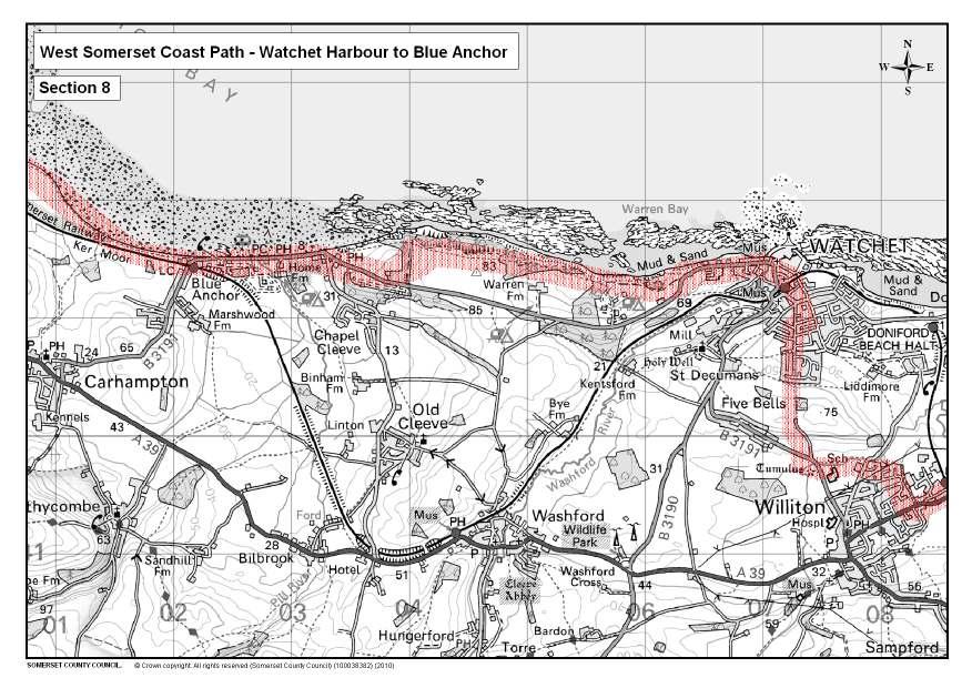
12 SECTION 8 - WATCHET HARBOUR TO BLUE ANCHOR 3.3 miles From the harbour, walk past the museum and the London Inn where the Mineral Line train once arrived. Continue up the steep hill of West Street taking care as it narrows. On reaching a way marker post at the top continue up some steps, through a blackthorn thicket. With a limekiln on your left cross over the stile. The site you have just entered is Dawes Castle, owned by English Heritage, which was used as a place of refuge against the threat of Viking attacks. At the highest point you can enjoy the 360-degree panoramic views. The steam rising from the valley comes from the Wansborough Paper Mill. This paper mill works with recycled paper and cargoes used to be unloaded in Watchet Harbour. Keeping the fence line on your right, proceed downhill to pass through a kissing gate. Walk on to follow a well worn, enclosed path, twisting and turning between trees and ground ivy. Soon the path surface is covered in stone chippings as it approaches an obvious concrete slipway. Cross the slipway to join the path moving away to the right. Exercise care, as it is narrow above the drop onto the slipway. Under the heavy disguise of an ivy covering are the remains of another lime kiln. Proceed on an enclosed path and you will eventually emerge from the trees into an open field on the left. Keep to the right-hand edge noting the public footpath sign to the beach at this point. It is a worthwhile detour. Follow round the field to a hedgerow gap about 100 yards ahead. There, turn right and pass through the kissing gate in the corner of the field. Walk up the slope through a wooded area. From the woods you have glimpses of fine views, but stay well away from the cliffs. Continue ahead up the slope on the wide field edge path between a fence and a hedge. Immediately inland the Washford radio masts can be seen. After walking up the slope, pass through a hedge gap with a way marker on a stout post. The views are now inland towards Exmoor. Continue along the field edge path rounding the end of this field to enter another field, ignore the fork to the right, and stay along the edge of the cultivated part of the field. On the seaward side is a classic example of a land slip. Stop at the next hedge gap to look straight ahead and you can appreciate why Dunster Castle was sited there: at the entrance to the valley into Exmoor.
13 Walk down the curving slope, through a wooded area, to arrive at a post and rail fence informing the public that a permissive path is used to walk on to Blue Anchor. The definitive public footpath has slipped away and is now probably at the bottom of the Bristol Channel! Please follow the waymarkers through the woods, climbing two short flights of steps until a junction is reached with a marker post. Turn sharp right and do not leave this path until a further enclosed path, entered by a gate, reaches the road. Take care when joining the road and walk downhill past the Blue Anchor Hotel to arrive on the sea front at Blue Anchor. The old name for Blue Anchor was Bradley Gate; the name Blue Anchor itself comes from the colour of the mud in the bay where vessels used to anchor. Veins of alabaster were found running through the blue lias and were quarried here from the 15th Century and used mainly for the construction of tombstones. The existing concrete sea wall was built to prevent the collapse of these lias cliffs and to stop the low lying fields inland from flooding. Blue Anchor offers a fine sandy beach at low water. Walk the whole length of the sea front where there are opportunities to take refreshment, the last place being the Driftwood Café at the end of the seafront. Again it is possible to access the Steam Railway for the final leg of the journey. Views across the arcing Blue Anchor Bay show you just how close it is to the final destination point in Minehead.
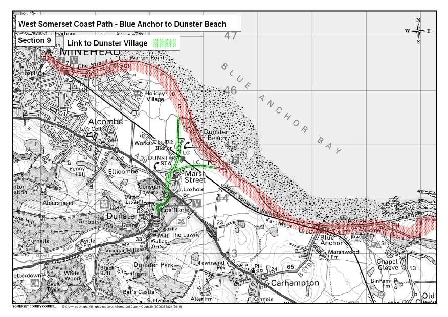
14 SECTION 9 - BLUE ANCHOR TO DUNSTER BEACH 1.6 miles Follow the public footpath on the beach side of the chalets. To your right is another piece of World War II defence infrastructure. Continue on the pebbles to follow the path running alongside the railway line. The tower on the tree-covered conical hill directly ahead is Conygar Tower, a folly built in1776. About halfway along the arc of the Bay stop there to look back towards Blue Anchor, inland to rolling fields, woodland and to the huge outline of Dunster Castle. The Castle is now owned by the National Trust but from 1376 to 1976 it was owned by the Luttrell Family. The Castle was extensively remodelled in the 1860`s and 1870`s. Stay on top of the pebble bank across the bridge on top of the rock filled baskets. Continue to walk along the top of the beach to arrive at a mixture of old and new timber posts, blocks of concrete and red sandstone boulders. Continue on this shoreline path and follow the hedge round and across the bridge over the flood relief channel to arrive at a car park. This is Dunster Beach, a privately owned beach with a public footpath clearly marked across the foreshore. At one time there was a weir harbour here, as there is at Porlock further along the coast.
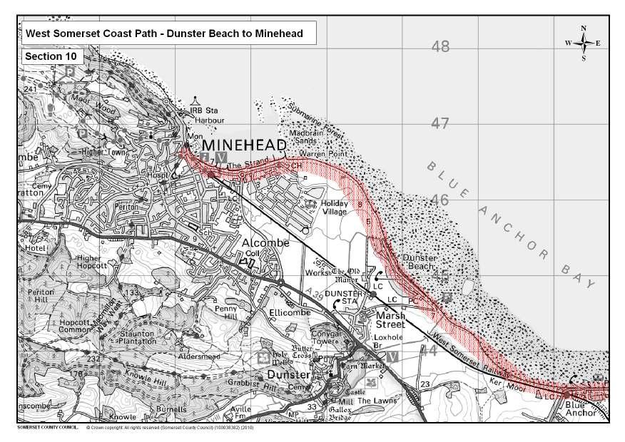
15 SECTION 10 - DUNSTER BEACH TO MINEHEAD 2.8 miles At the far end of the car park follow the waymarked signs on the seaward side of the beach huts. Some of these huts date back to the 1920 s but were requisitioned by the Army during World War II. Walk on to the very last chalet beyond which there are two further examples of pebble built World War II look-out posts, both in very good condition. A finger post points left to Dunster Station, which is about half a mile away. To the left is the outermost green of Minehead & West Somerset Golf Course. Please keep to the seaward side of the low white marker posts and proceed along an obvious path. There is a wide sandy beach on your right. Inland views open up once again with the Parish Church of St Peter at Minehead, prominent above the town, and the white pinnacles of Butlin s. Eventually a made-up path will be seen on a lower level to the left. This is a private path available only to the golfers. Stay on the path until the public path also drops to a lower level; Minehead harbour can be seen in the distance. Scrubby areas of sea buckthorn and blackthorn now screen the inland view and the path becomes enclosed. Continue along a sandy path to arrive adjacent to the golf course clubhouse, a small road roundabout and the start of the promenade along the seafront of the town. Walk the length of the promenade, passing Butlins and the railway terminus, towards the harbour. The dominant feature along the sea front is the view of a large wooded and inhabited hillside above Minehead known as North Hill. West of this hill lies Exmoor National Park. The official start point of the South West Coast Path National Trail is marked by a sculpture of hands holding a map. This also marks the end of the West Somerset Coast Path.
16 CIRCULAR WALK AROUND STERT POINT 1.5 miles From the car park, behind Dowell s Farm, follow the permissive path accessed beside the interpretation panel down to the beach. Turn right and follow the pebble bank and grass path. All along this stretch you will have wonderful views over Bridgwater Bay National Nature Reserve and across the Bristol Channel. The Bristol Channel has the second largest tidal range in the world and if you happen to be visiting during the rise or fall of the tide you can see the speed of the water and the large distance between high and low tide. The local habitat comprising salt marshes, sand dunes and mud flats provides an ideal location for wildlife, especially birds. Bridgwater Bay is particularly important as a feeding ground for migrating wildfowl and waders and is protected as a National Nature Reserve and European importance as a RAMSAR site. Wildfowl and waders use the area as a stop off during their migration, whilst other species such as curlew, shelduck and oystercatchers can be seen all year looking for worms in the sand and mud. At the end of the path pass through a wooden gate. From this point you have access to a variety of bird hides, including the impressive Tower hide. After enjoying the views over the reserve and river estuary return to the wooden gate. Turn right (south) and pass through a second wooden gate. As you start to follow the grass track you are now on the route of the River Parrett Trail, a fifty mile walk from the source of the river at Chedington in Dorset to the mouth of the river at Steart. Turn right and continue to follow the track. Notice the variety of stone walls made from pebbles and the local stone that mark the old and existing field boundaries. As you pass through the third wooden gate you now walk along the road passing a number of farms and ponds back to the car park.
17 CIRCULAR WALK AROUND KILVE AND EAST QUANTOXHEAD 2.7 miles This is a particularly pleasant walk combining both coastal views and church history, with a chance to enjoy refreshments on the way. From the oil retort at Kilve, follow the coast path using the instructions from Kilve earlier in the text. Pass the limekiln where the route is joined by a path leading down the steps to the beach. Along this part of the coastline a sport called glatting was once popular where conger eels were hunted with dogs at low tide. Continue on the coastal route up the hill with a fenced off path. Note the wonderful wind-shaped blackthorn clinging onto the cliff edge. In places it has lost the battle and the cliff has been eroded and washed into the sea. At the kissing gate turn left and follow the dense thicket hedge with bramble, gorse and blackthorn providing an ideal shelter for rabbits, badgers and foxes. Along this section there are glimpses of the stone faced banks that kept the livestock in the correct fields. If the field gates are shut use the stiles beside them. Directly in front of you inland are fine views of the bracken covered Smith s Combe on the edge of the Quantock Hills. At a point where the coast path continues up the hill, marked by a finger post, turn left down a public footpath. This charming sunken green lane (Underway Lane) lined with high hedges leads you back down towards the hamlet of East Quantoxhead. At the road bear left and after approximately 50 metres turn left into the field. Follow the footpath diagonally across the field heading for the impressive Court House and church. There is a chance to make a small detour to look in the fine church of St. Mary the Virgin. Inside the church beautifully carved bench ends depict designs of berries, grapes and leaves. Originally dating from mediaeval times, the church has fine examples of additions from various periods including the stones arches in the 13th Century and a 17th Century pulpit. Although the church was never a private chapel for the Luttrell family who have resided in the adjoining Court House for centuries, many family members have been the Rector of the parish. Returning to the path, pass through the kissing gate and over the grass car park. Go around the duck pond and down the stone track. There are tea gardens close by in the village if a drink and cake are needed. Walk along the track lined by thick beech hedges and a wonderful landscaped garden on the left. At the point where you can go left towards a stone bench and down to the beach, bear right and through a kissing gate. Follow the field headland. During the spring and summer another short detour is worthwhile to view the woodland flora such as bluebells, primroses and orchids in East Wood. Continue to follow the headland paths through two
18 boundaries and aim for the church at Kilve. Cross the stream on the wooden bridge and follow the signs into the churchyard. A short visit into the church of St. Mary s is worthwhile. Although less ornate than East Quantoxhead, the church displays fine examples of local craftsmanship and has close links with the nearby Chantry. Exit the churchyard via the wooden lytch gate. Again a refreshments stop is available at the tearooms, or you can return to the start point by turning left and following the tarmac road back to the car park. LINK TO WILLITON 0.9 miles Walk the whole length of Long Street, passing the old hospital on your right (now converted to residential apartments), to the road junction near the Co-op in the middle of Williton. Williton and its surrounding area had five water mills at one time. The remains of three can still be seen. One of these is at Bridge Farm and the other, a well-preserved example, now houses the interesting Bakelite Museum. The Church is also worth visiting, for although much rebuilt by the Victorians, it possesses an unusual font made of the local alabaster. Williton also has several pubs, takeaways and a bakery. From the junction turn right into North Street. Continue along the road past the school until you come to a metalled footpath with lampposts. Continue as main route.
19 CIRCULAR WALK AROUND ST AUDRIES WOOD 2.2 Miles Enter the Forestry Commission land and turn right. Follow the main track up the hill until you reach a bench. The view over the St. Audries estate shows the variety of land uses, including fields with grazing red and fallow deer, a small chapel and a range of grand buildings. The estate now hosts wedding ceremonies and receptions, but in the recent past it has been a Buddhist retreat and girls public school. Continue along the track ignoring paths off to the left. The woodland is predominantly a conifer plantation of spruce, fir and pine varying in age that has been planted at various times between 1961 and The dark green blocks are broken up by native species of tree and shrub such as silver birch, oak, beech, gorse and holly. Eventually the track turns right down a hill with a metal fence on the right to meet a gate. Go through the gate and then turn left. Proceed up the hill on a stone track passing a water reservoir. Pass through a gate within a gate and continue up the hill on a grass path. On both sides of the path rhododendron grows to a height that protects walkers from the wind and provides a splendid floral display in late spring. At the top of the path go through a kissing gate and turn left. Views straight ahead are of the Quantock heathland with a variety of floral species such as bracken, several species of heather and gorse. As you proceed along the well maintained path, you notice that the vegetation is kept away from the woodland to provide a fire break. When you reach the brow of the hill the views open up across the whole landscape you have walked already from the start point at Steart to Kilve. Keep the metal fence on your left as you start to descend the hill. About two thirds of the way down there is a metal gate in the fence with a Quantock Greenway marker. Turn left through the gate and then straight on to meet a stoned forest track. Turn right and follow the track downhill all the way back to the car park.
20 LINK TO DUNSTER VILLAGE 2.5 miles Dunster village is said to be the prettiest village in Exmoor National Park and it is really worth a visit. Turn left and out of the Dunster Beach car park entrance to follow Sea Lane. Cross the railway line and over a bridge. Turn left into Marsh Street and then left into Bremis Road. Follow the road around and then go up a small alley to access the pedestrian subway under the A39. Pass through and continue up the hill on the pavement to the village. On your way up the hill you will pass a large car park and then arrive at the Exmoor National Park Visitor Centre. As you continue round the corner the view down the High Street is of a picturesque medieval village with a wealth of heritage. From the 11th century Dunster Castle to the Old Yarn Market. Wandering through the village you will see many beautiful thatched cottages and other buildings which date from the 17th and 19th centuries, cobbled walkways and a restored working watermill. There are numerous pubs, shops, galleries and tearooms. Retrace your steps to the pedestrian subway under the A39 onto Marsh Street. Follow Marsh Street then bear left into Station Road. Continue along the road, cross the railway line and follow the road to the end. At the end of the road take the public footpath which starts near the Old Manor House. Continue past Lower Marsh Farm through a kissing gate then another kissing gate. Follow the path to the footbridge. Turn right at the footbridge and continue to the end of the footpath to rejoin the Coast Path.
21 GENERAL INFORMATION This guide has been produced by Somerset County Council Rights of Way Service which also maintains the walk. The route of the West Somerset Coast Path is subject to regular updating and improving. Please look out for signposts and waymarkers indicating sections of the path which may have changed since the publication of this booklet. We would welcome general comments on the walk using the prepaid postcard at the back of this guide. Whilst every effort has been made to ensure the accuracy of details given in this publication, Somerset County Council cannot accept responsibility for any errors or omissions, nor for any actions taken, or not taken, as a result of the information presented. USEFUL MAPS The most useful maps for walkers are the 1:25,000 Ordnance Survey Explorer Maps. The maps providing coverage of the Coast Path are OL9 (Exmoor) and 140 (Quantock Hills and Bridgwater). WAYMARKERS The walk is marked by discs with the ammonite symbol, which appears throughout this guide. You will also follow standard footpath waymarkers. Yellow arrows indicate footpaths, blue arrows indicate bridleways and white arrows indicate paths where access has been permitted by the landowner. PUBLIC RIGHTS OF WAY Most of the walk follows public rights of way but the land they cross is private. Please keep to the line of the path and do not stray from the waymarked route. If the path has to be diverted for any reason please follow the waymarkers rather then the map until you are guided back to the main route. If you find any of the route obstructed please follow the route as closely as possible and report the obstruction to the Rights of Way Service. PERMISSIVE PATHS Some of the route follows permissive paths. Please pay attention to any notices such as Keep to the path and please keep your dog on a lead. CAR PARKING Car parking is available at Steart, Stolford, Lilstock, Kilve, East Quantoxhead, Williton, Watchet, Blue Anchor, Dunster Beach, Dunster and Minehead. LOCAL ACCOMMODATION For accommodation providers please contact Somerset Visitor Centre on , or somersetvisitorcentre@somerset.gov.uk
22 PUBLIC TRANSPORT There are several bus services between Minehead, Dunster, Watchet, Williton, West Quantoxhead, Kilve, Cannington and Bridgwater. For details please call Traveline Public Transport Information on Information on West Somerset Railway can be obtained on PUBLIC TOILETS Toilets are available at Kilve, Williton, Watchet, Blue Anchor, Dunster Beach, Dunster and Minehead. SHOPS & TEAROOMS, ETC There are shops at Kilve, Williton, Watchet, Dunster and Minehead. Refreshments are available at Kilve, East Quantoxhead, Williton, Watchet, Blue Anchor, Dunster and Minehead. USEFUL ADDRESSES Rights of Way Service, Somerset County Council, County Hall, Taunton, TA1 4DY. Quantock Hills AONB Service DOGS Please remember that dogs should be kept under close control. It is an offence to allow a dog to attack or chase livestock and it is advisable to keep dogs on a lead when passing near to livestock and close to farmyards. COUNTRYSIDE CODE Be safe, plan ahead and follow any signs. Leave gates and property as you find them. Protect plants and animals and take your litter home. Keep dogs under close control. Consider other people. TOURIST INFORMATION CENTRES Bridgwater Sedgemoor District Council, Bridgwater House, King Square, Bridgwater TA6 3AR Tel: Fax: bridgwater.tic@sedgemoor.gov.uk Watchet The Esplanade, Watchet, TA23 0AJ Tel: Fax: townclerk@watchettowncouncil.org
23 Dunster Dunster Steep, Dunster, TA24 5SG Tel: Minehead 17 Friday Street, Minehead, TA24 5UB Tel: Fax: ACKNOWLEDGEMENTS Route development Sarah Littler Improvements to Route Andy Coleman, Andy Stevenson Text, drawings and photographs David Edwards, Sheila Burger, Andy Stevenson, Glenn Martin, Quantock Hills AONB, Countryside Agency, Mary Williams Thanks to Chris Adams, Grant Turner, Keith Denner, Mike Bellamy, Steve Kirby, SCC Rights of Way, Somerset Highways
24
25
26
27
28
29
30
31
32
33
34
Walk 2: doniford to east quantoxhead
 Walk 2: doniford to east quantoxhead Length: 9 ¼ miles / 15km Good For: Difficulty: Moderate Theme: Nature Notes: This walk is tidal - please check tide times before setting off. Dogs are welcome but need
Walk 7: Watchet to washford
 Walk 7: Watchet to washford Length: Moderate - 7.5 miles / 12 km Good For: Theme: History Duration: 2-3 hours depending on speed of walking Notes: This is a moderate to difficult walk in places, with steps,
Beautiful Walks from the Blue Ball Inn
 Walk No. 7 COAST AND VALLEY WALK Countisbury, Glenthorne, County Gate, Brendon, Rockford and Wilsham 10 MILES APPROX. Walking time 5 hours approx. (not including breaks)> OS Sheet 64/74 Lynton and Lynmouth.
Lincolnshire Limewoods Walks. Woodhall Spa. A circular walk of 13km (8 miles)
") Lincolnshire Limewoods Walks Woodhall Spa A circular walk of 13km (8 miles) Introduction The Lincolnshire Limewoods is an area between Wragby, Bardney and Woodhall Spa. It is a fantastic place to explore
Lincolnshire Limewoods Walks Woodhall Spa A circular walk of 13km (8 miles) Introduction The Lincolnshire Limewoods is an area between Wragby, Bardney and Woodhall Spa. It is a fantastic place to explore
The Mendip Way. Route Directions and Maps Wells to Frome
 The Mendip Way Route Directions and Maps Wells to Frome Website: www.mendiphillsaonb.org.uk Email: mendip@mendiphillsaonb.org.uk Facebook & Twitter: @MendipHillsAONB Phone: 01761462338 1 Wells to Shepton
THE WELLDIGGERS ARMS, HESWORTH AND FITTLEWORTH TRAIL
 THE WELLDIGGERS ARMS, HESWORTH AND FITTLEWORTH TRAIL 5.5 miles Circular 3 hours 041017 Challenging Terrain A 300-year-old pub turned country-inn on the edge of the South Downs National Park, The Welldiggers
The Hundred Parishes
 The Hundred Parishes Walks from railway stations number 9 6.4 miles (10kms) from Bishop s Stortford to Stansted Mountfitchet Start: Bishop s Stortford station (Grid Reference TL492209) (ample parking and
BALCOMBE AND ARDINGLY RESERVOIR, WEST SUSSEX
 BALCOMBE AND ARDINGLY RESERVOIR, WEST SUSSEX 7 miles Circular 4 hours 080816 Challenging Terrain Hi, I'm Luke and this is my West Sussex Weekends walk It's a 7 mile loop from Balcombe rail station, taking
8 Miles Circular 4 hours
 VISIT RYEDALE HELMSLEY AND RICCAL DALE 8 Miles Circular 4 hours 090616 Challenging Terrain An 8 mile (13km) circular walk from the market town of Helmsley in Ryedale. The route heads out across sheep pastures
Danbury Words and pictures by Laurie Page of the Public Rights of Way team at Essex County Council.
 Danbury Words and pictures by Laurie Page of the Public Rights of Way team at Essex County Council. An undulating walk from Danbury village to the bluebells at the National Trust property of Blakes Wood.
10 Miles Circular 5 hours
 VISIT RYEDALE PICKERING AND CAWTHORN CAMPS 10 Miles Circular 5 hours Moderate Terrain 120616 A 10 mile (16km) there and back walk from the market town of Pickering in Ryedale. The route heads north through
Lincolnshire Walks. Ancaster. Three cir cular walks of2 3/4,4or 6km (11/3, 21/2 or 33/4 miles)
") Lincolnshire Walks Ancaster Three cir cular walks of2 3/4,4or 6km (11/3, 21/2 or 33/4 miles) Introduction These walks are set in the attractive countryside around the historic town of Ancaster. The town
Lincolnshire Walks Ancaster Three cir cular walks of2 3/4,4or 6km (11/3, 21/2 or 33/4 miles) Introduction These walks are set in the attractive countryside around the historic town of Ancaster. The town
LDWA SOUTH DOWNS MARATHON
 AHD ahead SDW South Downs Way BL/BR bear left/bear right TL/TR turn left/turn right SP signpost/fingerpost X cross LEG 1 - EAST DEAN to WP1 NORTON GR 470019. Open 1030 to 1300. 9.6 miles. 1.1 From village
This walk description is from happyhiker.co.uk
 This walk description is from happyhiker.co.uk Pendle Hill Walk From Barley Starting point and OS Grid reference Ordnance Survey map Distance Traffic light rating Barley village honesty box car park OS
Sandilands to Huttoft Bank
 Coastal Country Park Walks Sandilands to Huttoft Bank A CIRCULAR WALK OF 11KM (7 MILES) INTRODUCTION The Lincolnshire Coastal Country Park lies between Sandilands, Chapel St Leonards and Huttoft on the
Hammer Vale and Linchmere Common
 point your feet on a new path Hammer Vale and Linchmere Common Distance: 9 km=5½ miles or 6 km=3¾ miles easy walking with one steep section Region: Hampshire, West Sussex Author: Botafuego Refreshments:
Chapel Point to Anderby Creek
 Coastal Country Park Walks Chapel Point to Anderby Creek A CIRCULAR WALK OF 8.5 OR 6 KM (5.3 OR 3.75 MILES) INTRODUCTION The Lincolnshire Coastal Country Park lies between Sandilands, Chapel St Leonards
Lincolnshire Walks. Grainthorpe. Three circular walks of 2 ¾, 9 and 9 ½ km (1 ¾, 5 ½ and 6 miles)
") Lincolnshire Walks Grainthorpe Three circular walks of ¾, 9 and 9 ½ km (1 ¾, ½ and 6 miles) Introduction Explore the coastal marshes, arable hinterland, Louth Navigation canal and the village of Grainthorpe
Lincolnshire Walks Grainthorpe Three circular walks of ¾, 9 and 9 ½ km (1 ¾, ½ and 6 miles) Introduction Explore the coastal marshes, arable hinterland, Louth Navigation canal and the village of Grainthorpe
9.5 km Circular 3 hours
 RANMORE CIRCULAR A 6 mile (9.5km) circular walk from Boxhill and Westhumble Station in the village of Westhumble, passing through part of the Polesden Lacey Estate, Ranmore Common and Denbies Vineyard.
Husthwaite to Byland Abbey
 Husthwaite to Byland Abbey This walk begins with a loop round the village of Husthwaite and continues towards Coxwold along a disused railway line, which is now a right of way. It passes through Coxwold
9.5 km Circular 3 hours
 MEDIEVAL WAVERLEY Challenging Terrain A 6 mile (9.5km) undulating circular walk from Tilford village passing close to The Sands village and the historic ruins of Waverley Abbey. From the top of Crooksbury
Approximate distance: 5.5 miles For this walk we ve included OS grid references should you wish to use them. Start. End
 Approximate distance: 5.5 miles For this walk we ve included OS grid references should you wish to use them. End 4 1 Start 3 2 N W E S Reproduced by permission of Ordnance Survey on behalf of HMSO. Crown
THE DOG AND DUCK HAREWOODS ESTATE TRAIL. 6 Miles Circular 3 hours. Getting there. Walk Sections
 THE DOG AND DUCK HAREWOODS ESTATE TRAIL Moderate Terrain A 6 mile circular pub walk from the Dog and Duck in Outwood, Surrey. The Dog and Duck is a delightful pub where everyone is made welcome. From walkers
Bonnie Prince Charlie Walk
 Bonnie Prince Charlie Walk A waymarked route from Ashbourne to Derby to celebrate the 60th anniversary (1995) of the formation of the Ramblers' Association. This route follows the general direction of
LDWA SOUTH DOWNS MARATHON 13 th MAY 2018
 AHD ahead SDW South Downs Way BL/BR bear left/bear right TL/TR turn left/turn right X cross LEG 1 - EAST DEAN to WP1 NORTON GR 470019. Open 1030 to 1300. 9.7 miles. 1.1 From village hall TL and walk to
EAST GRINSTEAD AND THE HIGH WEALD, WEST SUSSEX
 EAST GRINSTEAD AND THE HIGH WEALD, WEST SUSSEX 7 miles Circular 3.5 hours 301015 Challenging Terrain Hi, I'm Tom and this is my West Sussex Weekends walk. I live and work in London but often head out of
There are toilets at Manningtree Station, Flatford (close to the hump back bridge) and in Dedham.
 and in Dedham.") Arriving by Train Main Features of the Walk Outline Route Employs particularly attractive paths, many of which offer impressive views across Dedham Vale. Includes a section along the tidal section of the
Arriving by Train Main Features of the Walk Outline Route Employs particularly attractive paths, many of which offer impressive views across Dedham Vale. Includes a section along the tidal section of the
Welsh Newton and Woodland
 Welsh Newton and Woodland This is a 8.2km miles (approx) walk which will take about 2.5 hours at a relaxed and leisurely pace. There are a few hills but no steep inclines. Start at Llangrove bus stop and
Redesdale Arms. A Trio of Walks
 Redesdale Arms A Trio of Walks Welcome to The Redesdale Arms Hotel The award winning 34 bedroom Redesdale Arms Hotel sits at the gateway to the Cotswolds in the High Street of the historic town of Moreton-in-Marsh.
The North Pennines from near Langwathby
 3.6 Langwathby to Armathwaite Map panel?? Distance 12.7 miles (20.5 km) Terrain farm, woodland and riverside paths; some potentially muddy tracks; a few short sections of road Grade gently undulating Food
ST. AGNES. you cannot put a time limit on beauty.
 ST. AGNES CIRCULAR WALKS AROUND There are many enjoyable and picturesque walks around St. Agnes most are signposted and are featured on the St. Agnes Mini-guide map. Because most of our footpaths are in
Slindon Folly - South Downs, West Sussex
 Slindon Folly - South Downs, West Sussex Starts at Park road-side near entrance to Slindon College 2 hours 15 minutes 4.5miles 7.2km Easy ID: 0.1598 Developed by: Chris Mumford Checked by: Rockpit www.ramblersroutes.org
Masson Hill. Walk. Approximately 4 km. Moderate Walk Begins from Matlock Railway Station
 Masson Hill Walk Approximately 4 km Moderate Walk Begins from Matlock Railway Station TOWN WALKS Masson Hill walk is approx. 4 km. It can be walked in a couple of hours or so. Enjoy your walk and the beautiful
For more information and to buy this book click here ISBN: CICERONE. Guides for walkers, trekkers, mountaineers, climbers and cyclists
 For more information and to buy this book click here ISBN: 9781852845377 CICERONE Guides for walkers, trekkers, mountaineers, climbers and cyclists www.cicerone.co.uk WALK 5 Ouston and Urpeth Distance
A circular walk of or km (2 1 4 or miles)
") Grantham A circular walk of 3 3 4 or 5 3 4 km (2 1 4 or 3 1 2 miles) Introduction This relatively short circular walk, which starts in the middle of Grantham, offers plenty of variety. The route takes
Grantham A circular walk of 3 3 4 or 5 3 4 km (2 1 4 or 3 1 2 miles) Introduction This relatively short circular walk, which starts in the middle of Grantham, offers plenty of variety. The route takes
Walk Description. Directions
 Title: Saffron Trail: Battlesbridge to Chelmsford Distance: 14¾ miles Time taken: 6 hours Start Point: Outside the Barge Inn, Battlesbridge OS Explorer Map: 175 & 183 Grid Ref.: TQ 780 947 Transport: Rail:-
Although the majority of these walks are around country lanes you should still follow the Country Code:-
 With the update of the Parish Plan was a request for details of any Walks around Pillaton The following pages give several walks that I and my wife have done for many years. Please be aware that NONE OF
Approximate distance: 10 miles For this walk we ve included OS grid references should you wish to use them. Start. End
 Approximate distance: 10 miles For this walk we ve included OS grid references should you wish to use them. 2 3 Start End 1 N W E S Reproduced by permission of Ordnance Survey on behalf of HMSO. Crown
NETTLESTEAD & YALDING
 NETTLESTEAD & YALDING ULL CIRCUIT - Sheet 1 (first and last sections) Open fields (see 'Introductory Notes') 88 Direction label (as in the walk notes) ROADS: 81 10m Significant roads Redhill arm North
Hascombe and Winkworth Arboretum Downs Link Path, Smithbrook Kilns
 point your feet on a new path Hascombe and Winkworth Arboretum Downs Link Path, Smithbrook Kilns Distance: 18 km=11 miles Region: Surrey Author: RDC easy walking Date written: 7-may-2016 Last update: 30-aug-2018
No. 1 By River Ribble & Brungerley Park 3¼ Miles,
 RVRNEWS 102 No. 1 By River Ribble & Brungerley Park 3¼ Miles, Approx 2 Hours This walk starts at the gate on platform 2 of Clitheroe station. Leaving the station turn left making towards Kirkmoor Rd and
Saltash, Cornwall - Railways, Rivers & Castles
 Saltash, Cornwall - Railways, Rivers & Castles Starts at St Stephen's Church, Saltash, Cornwall 2 hours 45 minutes 5.5miles 8.9km Easy ID: 0.2532 Developed by: Peter Clements Checked by: Kevin Connor www.ramblersroutes.org
Shepherdswell - Dover
 Shepherdswell - Dover The North Downs Way > Shepherdswell to Dover Introduction This part of the path is slightly different in character from most other parts of the path since it spends much of the time
NEWLANDS CORNER AND ST MARTHAS
 NEWLANDS CORNER AND ST MARTHAS 10k CIRCULAR ROUTE 2½-3HRS GU4 8SE From Newlands Corner on the North Downs just outside Guildford, you can enjoy one of the most beautiful panoramas of quintessential English
Harlington - Sharpenhoe - Pulloxhill
 Harlington - Sharpenhoe - Pulloxhill ID: 3676, Distance: 8 miles, Height gain: 140 Metres, Map: Explorer 193 Luton & Stevenage, Contributor: Dennis Jeanes Duration: 3 Hours 27 Mins Features Church,Great
Waterhead Pier to Orrest Head, Windermere and Bowness
 Waterhead Pier to Orrest Head, Windermere and Bowness A 4 1 2 hour walk through Woodlands and the Troutbeck Valley with spectacular Lake and Mountain views and a lakeshore path. Walk 10 Walk 11 Walk 12
Follow the Lantern Way clockwise from Dursley Town Hall through Cam & Coaley to Uley and back to Dursley (about 14 miles)
") According to the Rev Kilvert's diary of 1873, couples on their way to evening services in winter followed a practical though unusual local tradition: "My Mother says that at Dursley, when ladies and gentlemen
According to the Rev Kilvert's diary of 1873, couples on their way to evening services in winter followed a practical though unusual local tradition: "My Mother says that at Dursley, when ladies and gentlemen
Countryside Walks. 1) Highclere Park Public Walk.
 Highclere Park Public Walk.") 1) Highclere Park Public Walk. Access: From Highclere Estate Main Entrance at Whitway, please note there is no parking on site or access for vehicles. Open: Throughout the year. Description: This footpath
1) Highclere Park Public Walk. Access: From Highclere Estate Main Entrance at Whitway, please note there is no parking on site or access for vehicles. Open: Throughout the year. Description: This footpath
Christchurch to Hengistbury Head
 Last checked 6 June 2018 Document last updated: 13 July 2018 This document and information herein are copyrighted to Saturday Walkers Club. If you are interested in printing or displaying any of this material,
Murlough. Dunes open access, some restricted areas Woodland open access, some restricted areas
 A2 Belfast Road Dundrum Murlough P3 N Dundrum Bay boathouse Ballykinler MOD Firing Range P4 P5 Downshire Bridge inlet floods at high tide Murlough Farm Private PNT Murlough House Private Seals agricultural
Bagshot Heath and Swinley Forest
 point your feet on a new path Bagshot Heath and Swinley Forest Distance: 13 km=8 miles Region: Berkshire, Surrey Author: Botafuego Refreshments: Forest Look Out, Bagshot easy walking Date written: 17-feb-2013
RILLINGTON TO MALTON by Tania Dickinson
 RILLINGTON TO MALTON by Tania Dickinson This walk takes you from the Vale of Pickering up on to the Wold scarp, before dropping down again through the pretty village of Settrington and joining the Centenary
LOCAL CIRCUIT EM1: EAST MALLING & BARMING HEATH. N 2m ROADS: Significant roads PATHS: Starting direction Barming Longsole Mission Church
 Ditton Church Scott Close LOCAL CIRCUIT EM1: EAST MALLING & BARMING HEATH 6 Community Centre F Open fields (see 'Introductory Notes') 1m 88 Direction label (as in the walk notes) East Malling Church -
GENERAL INFORMATION PLEASE FOLLOW THE COUNTRYSIDE CODE:
 KNIGHTON CIRCULAR WALKS The East Radnor Group of the Ramblers Association invites you to enjoy these walks around Knighton. Knighton is an excellent centre for walks in the lovely unspoilt mid-wales countryside
Dyrham and Hinton Parish Walks
 Dyrham and Hinton Parish Walks A series of five walks in the parish, exploring most of the public footpaths. By John Miller Each walk is described in detail, with a complete map, to provide a handy guide
Bakewell Club Site - Robin Hood's Stride
 Bakewell Club Site - Robin Hood's Stride Camping and Caravanning Route Summary A circular walk with fabulous views winding it's way through the beautiful White Peak scenery. Points of interest include
Distance: 14 km=8½ miles or 7 km=4½ miles easy-to-moderate walking
 point your feet on a new path Normandy Distance: 14 km=8½ miles or 7 km=4½ miles easy-to-moderate walking Region: Surrey Author: Botafuego Refreshments: Pirbright, Ash date written: 20-feb-2012 date revised:
For Your Own Safety. Please make a note below of the contact number that should be used in the event that you get lost or require other assistance
 Respect Protect Enjoy Respect other people Consider the local community and other people enjoying the outdoors Leave gates and property as you find them and follow paths unless wider access is available
CHINTHURST HILL AND THE GRANTLEY ARMS, SURREY
 CHINTHURST HILL AND THE GRANTLEY ARMS, SURREY 4 miles Circular 2 hours 110417 Challenging Terrain A 4 mile (can be shortened to 3 miles) circular pub walk near Wonersh in Surrey. The walk begins with an
Coast Survey Stretch 03 Seaview High Street to Sandown Zoo
 Coast Survey Stretch 03 Seaview High Street to Sandown Zoo Overview map of the stretch Introduction The route starts at the attractive village of Seaview, through the wooded Priory Bay, passing the remains
Thornton le Dale Walks
 Thornton le Dale Walks A collection of walks in and around the village Thornton le Dale Traders Forum www.visitthorntonledale.co.uk Thornton le Dale Walks Walk 1: Beck Isle Cottage and All Saints Church
The Foreshore Walk. 24m. 1m Lake Macquarie LGA. 1 hr 15 mins 2.9 km One way. Hard track 81m
 The Foreshore Walk 1 hr 15 mins 2.9 km One way Hard track 81m This walk traverses the coastline of the Green Point reserve. By following a variety of tracks and occasionally traveling inland through eucalyptus
Thornton le Dale Walks
 Thornton le Dale Walks A collection of circular walks in, and around, the village www.visitthorntonledale.co.uk Thornton-le-Dale Traders Forum and Thornton le Dale Parish Council 1 Thornton le Dale Circular
Uif!Sfe!Mjpn-!Mpnhepn! bne!dbnnpdl!dibtf-! Tubggpsetijsf
 Uif!Sfe!Mjpn-!Mpnhepn! bne!dbnnpdl!dibtf-! Tubggpsetijsf 7/6!njmft! Djsdvmbs!!!!!!! 4!up!4/6! ipvst Strenuous Terrain Uif!Sfe!Mjpn!jt!b!dmbttjd!wjmmbhf!qvc-!b! hsfbu!qmbdf!up!tbujtgz!zpvs!ivnhfs!bgufs!b!
Footpaths and walks in the Leckhampton Fields
 APPENDIX 5 Footpaths and walks in the Leckhampton Fields Because of its network of footpaths, the Leckhampton Fields have many different walks. The rich diversity of landscape, hedgerows, trees, streams,
Winterfold Wood. point your feet on a new path. In Brief
 point your feet on a new path Winterfold Wood Distance: 8½ km=5¼ miles Region: Surrey Author: Schwebefuss Refreshments: Windmill Inn, Peaslake after the walk moderate walking with many gradients Date written:
Walks in Lenham. Three delightful walks in and around Lenham from 30 minutes to 90 minutes with map and photographic guides. l l l ABOUT LENHAM
 Walks in Lenham Three delightful walks in and around Lenham from 0 minutes to 90 minutes with map and photographic guides l l l ABOUT LENHAM The medieval village of Lenham, in the Borough of Maidstone,
Walk 3 - Woodbridge and Melton A Walk Round Waldringfield by Sue and Jim Stacey. Woodbridge. shopping centre, cafes, toilets etc. tide mill.
 Walk 3 - Woodbridge and Melton A Walk Round Waldringfield by Sue and Jim Stacey. road with roundabout church railway with station walk route showing description direction track, wide path, bridlepath footpath
THE PONTON PLOD - 27 MILE ROUTE
 THE PONTON PLOD - 27 MILE ROUTE Emergency Phone Number 07771 813514 Abbreviations: BW Bridleway X Cross immd immediately FP Footpath TL Turn left L Left thro through KG Kissing Gate TR Turn right R Right
Maps The maps provided are a guide and are not to scale. Please use OS Explorer Map 120 (Chichester).
.") A Walker s Guide - Chichester Harbour Useful Information Directions All the walks were tested in 201. Please note, however, that some footpaths may be diverted and buildings such as pubs may have changed
A Walker s Guide - Chichester Harbour Useful Information Directions All the walks were tested in 201. Please note, however, that some footpaths may be diverted and buildings such as pubs may have changed
Tideswell to Castleton
 Tideswell to Castleton 1 Walk summary Length: 14 km, 8.5 miles Maps: OS Explorer OL1 The Peak District - Dark Peak Area, OS Explorer OL24 The Peak District - White Peak Area, OS Landranger 110 Sheffield
Weatherman Walking. Approximate distance: 5.5 miles For this walk we ve included OS grid references should you wish to use them. Start.
 Approximate distance: 5.5 miles For this walk we ve included OS grid references should you wish to use them. 4 1 Start End 3 2 N W E S Reproduced by permission of Ordnance Survey on behalf of HMSO. Crown
A Walk around Holmes Chapel starting & finishing at Holmes Chapel Railway Station. by Tony & Lindsay Wright (2016)
") A Walk around Holmes Chapel starting & finishing at Holmes Chapel Railway Station. by Tony & Lindsay Wright (2016) Introduction Holmes Chapel Railway Station is on the Crewe to Manchester line. The station
A Walk around Holmes Chapel starting & finishing at Holmes Chapel Railway Station. by Tony & Lindsay Wright (2016) Introduction Holmes Chapel Railway Station is on the Crewe to Manchester line. The station
Walks Around Bishopstone & Hinton Parva
 The Walks: From ½ mile ambles to 8 mile scenic loops Hinton Parva Walks H1 H2 H3 Bishopstone Walks B1 B2 B3 B4 B5 Walk B1: Bishopstone Village, The Dingle (stream) & Pond A short circular village amble
Uif!Cmbdl!Kvh!bne! Wbsnibn!Qbsl-!Ipstibn-! Wftu!Tvttfy
 Uif!Cmbdl!Kvh!bne! Wbsnibn!Qbsl-!Ipstibn-! Wftu!Tvttfy 7/6!njmft! Djsdvmbs!!!! 3/6!up!4! ipvst 200114 Moderate Terrain Uif!Cmbdl!Kvh!jt!b!hsfbu!upxn!qvc!dfnusfe! bspvne!b!mbshf!cbs!xjui!xppefn!qbnfmmjnh-!
10 km Circular 3 hours
 FRIMLEY AND FRIMLEY GREEN 10 km Circular 3 hours Easy Terrain 250716 A 10km (6 mile) circular walk exploring the canal towpath, riverside path, woodland, heath and small settlements around Frimley in Surrey.
Rhossili - Tears Point - Mewslade Bay - Talgarth's Well - Rhossili - ID: 148. Walk description:
 Walk description: A glorious walk combining thrilling cliffs with beautiful wild beaches and a bird's-eye view of the Gower peninsula from Rhossili Down. The adventurous can walk out to the Worm's Head
How to get there. Respect - Protect - Enjoy
 How to get there Driving: Postcode is RG9 5PF and there is a car park just across from the pub. Nearest station: Henley-on-Thames station is 5.6 miles away. We re delighted to present three circular walks
Hindleap and Vachery Ashdown Forest, Chelwood Gate, Forest Row
 point your feet on a new path Hindleap and Vachery Ashdown Forest, Chelwood Gate, Forest Row Distance: 5 km=9½ miles Region: East Sussex Author: Stivaletti Refreshments: Chelwood Gate, Forest Row Map:
Walk Description. Directions
 Title: East Hanningfield Distance: 8 miles / 9 miles Time taken: 3-3½ hours Location: 5 miles south east of Chelmsford Parking: Free car park off The Tye, East Hanningfield, next to the primary school
Ashdown Forest, Fairwarp Rock Wood and Purple Heather
 point your feet on a new path Ashdown Forest, Fairwarp Rock Wood and Purple Heather Distance: 14 km=9 miles or 2 walks of 10 km=6 miles and 8 km=5 miles moderate walking Region: East Sussex Author: Stivaletti
6 Miles Linear 3 hours
 SPIRES AND STEEPLES Part 2: BRANSTON TO METHERINGHAM 6 Miles Linear 3 hours 160818 Moderate Terrain A 6 mile (10km) linear walk from Branston to Metheringham, forming the second part of the Spires and
Oldbury & Littleton, South Gloucestershire
 Oldbury & Littleton, South Gloucestershire Starts at Church Lane, Oldbury. BS35 1QF 2 hours 0 minutes 5.2miles 8.4km Easy ID: 0.2468 Developed by: GEOFF MULLETT Checked by: Marion Stone www.ramblersroutes.org
Ambergate & Betty Kenny's Tree.
 Walk Information Walk Area: Ambergate OS Map: Explorer OL24 Distance: 4 Miles White Peak Area Start Point: Holly Lane, Ambergate 1:25000 Map Ref: SK 346 254 Post Code N/A General Information Altitude Data
Outdoor property Access Statement Northumberland Coast
 Outdoor property Access Statement Northumberland Coast 7a The Square, Low Newton-by-the-Sea, Alnwick, Northumberland NE66 3EL T: 01665 576874 E: northumberlandcoast@nationaltrust.org.uk Introduction The
Hunters Hill to Epping Road
 Hunters Hill to Epping Road 2 hrs 30 mins 5.5 km One way Moderate track 154m An enjoyable walk through lower sections of the Lane Cove National Park, this walk features plenty of mangroves next to the
Green Man Ultra Route Directions 2018
 Green Man Ultra Route Directions 2018 Start-CP1 (9 miles) Community Forest Path (CFP) Frome Valley Way (FVW) From the starting line cross the playing fields diagonally to the metal gates in the hedge lined
Poundgate and The Hurstwood
 point your feet on a new path Poundgate and The Hurstwood Distance: 11 km=7 miles Region: East Sussex Author: Stivaletti Refreshments: High Hurstwood easy walking Date written: 24-jul-2016 Last update:
Maps The maps provided are a guide and are not to scale. Please use OS Explorer Map 120 (Chichester).
.") A Walker s Guide - Chichester Harbour Useful Information Directions All the walks were tested in 2013. Please note, however, that some footpaths may be diverted and buildings such as pubs may have changed
A Walker s Guide - Chichester Harbour Useful Information Directions All the walks were tested in 2013. Please note, however, that some footpaths may be diverted and buildings such as pubs may have changed
Dorridge & District Residents Association A Walk Along The Green Belt From Dorridge to Catherine-de-Barnes
 Dorridge & District Residents Association A Walk Along The Green Belt From Dorridge to Carine-de-Barnes The starting section of this walk through open fields would be destroyed by building of motorway
holly tree Wellhill Farm Woodyard Bramham House red kites Round House ha-ha
 This 6.4 mile walk around the magnificent Bramham Park Estate has been made possible with the active support of the owner of the Estate, Nick Lane Fox, with funding from Natural England, as part of Defra
11 Miles Linear 5 to 6 hours
 11 Miles Linear 5 to 6 hours Sussex Hospices Trail Part 21: BALCOMBE TO HORSHAM Moderate Terrain 030918 An 11 mile linear walk from Balcombe rail station to Horsham rail station in West Sussex, forming
Hexham Abbey to the Racecourse Road
 Hexham Abbey to the Racecourse Road The Yarridge Road, or Racecourse Road as it is often known, runs along the ridge line to the south of Hexham and provides wonderful views of the river valley and fells
Cilgerran Wildlife Park Circular Walk
 Walking embrokeshire Cilgerran Wildlife ark Circular Walk It s good to walk, so why not step out and sample some of the walks your neighbourhood has to offer. This pleasant and interesting walk which starts
Stokenchurch. Bluebell Woods, Bomber Memorial, Red Kites, Getty s Cricket Ground, Nature Reserve
 Stokenchurch Bluebell Woods, Bomber Memorial, Red Kites, Getty s Cricket Ground, Nature Reserve Bomber Memorial The best time to visit Cowleaze Wood is in the spring when there is a memorable display of
Walking Pembrokeshire.
 Walking Pembrokeshire Canaston Woods Walk It s good to walk, so why not step out and sample some of the walks your neighbourhood has to offer. This pleasant and interesting walk which starts and finishes
5 Miles Circular 2.5 hours
 VISIT RYEDALE KIRKBYMOORSIDE AND ST GREGORY S MINSTER Challenging Terrain A 5 mile (8 km) circular walk from the market town of Kirkbymoorside in Ryedale. The route heads west through open fields and pastures,
East Lulworth Ride Route 5
 East Lulworth Ride Route 5 Out of ar Experience - ycling in Purbeck ircular route from Wareham to Lulworth - 18 miles + Lulworth ove oombe Keynes River Frome Time needed: 3-4 hours + Grading: Moderate
Walk 2: Beamsley Beacon and Bolton Abbey
 Walk 2: Beamsley Beacon and Bolton Abbey Start and Finish: The Memorial Hall, Main Street, Addingham, LS29 0LZ, SE 079 497 The shortest walk is about 5½ miles (8.8km) The medium Walk is about 8¼ miles
Clyde Walkway Community Links: Crossford Stonebyres Nemphlar- Kirkfieldbank
 Clyde Walkway Community Links: Crossford Stonebyres Nemphlar- Kirkfieldbank Crossford Stonebyres Nemphlar - Kirkfieldbank Digital Trail Difficulty (out of 3) 2 Distance 1. Crossford to Kirkfield Bank Bridge