Trial Restriping Project. October 21, 2010
|
|
|
- Chad Robinson
- 6 years ago
- Views:
Transcription
1 Arastradero Road Trial Restriping Project P t C t ti C it O t hm ti N 1 Post Construction Community Outreach Meeting No. 1 October 21, 2010
2 Agenda Staff Introductions Project Background Project Status Traffic Data Collection Summary Current CommunityInput Proposed Immediate and Long Term Improvements Question/Answers
3 Project Background Charleston Arastradero Traffic Calming Project Arastradero Rd Community Input Period One Year Trial Period (Aug ) Lane Reduction Traffic Calming Treatments
4 Project Status Major Construction Complete Aug/Sept 2010 Pavement Surface Treatment Trial Restriping Pending Arastradero Rd Improvements Final Bike Lane/Parking Lane Bike Lane Stencils Clemo Av Suzanne Dr Crosswalk Nov 2010 Coulombe Dr Traffic Signal Modification Nov 2010 On Going One Year Trial Period Monitoring
5 Pre Project Traffic Count and Speed dsummary Arastradero May 2010 w/o Georgia e/o Pomona e/o McKellar AM - EB AM - WB PM - EB PM - WB Average Daily 18,523 18,458 18,137 85% Speed
6 Pre Project Traffic Count and Speed dsummary Arastradero May 2010 w/o Georgia e/o Pomona e/o McKellar Donald Maybell AM - EB AM - WB PM - EB PM - WB Average Daily 18,523 18,458 18, ,638 85% Speed
7 Post Project Data #1 Oct 2010 Traffic Count and Speed dsummary Arastradero October 2010 AM - EB AM - WB w/o Georgia e/o Pomona e/o McKellar PM - EB 1, PM - WB Average Daily 18,022 18,467 18,064 85% Speed
8 Post Project Data #1 Oct 2010 Traffic Count and Speed dsummary Arastradero October 2010 w/o Georgia e/o Pomona e/o McKellar Donald Maybell AM - EB AM - WB PM - EB 1, PM - WB Average Daily 18,022 18,467 18, ,646 85% Speed
9 Travel Time Survey Summary October 2010 Westbound Alma St to Foothill (El Camino to Gunn HS) a Eastbound Gunn HS to Alma St (Gunn HS to El Camino) AM Peak Hour Average 8:40 (4:29) 6:43 (4:07) 7:25AM to 8:00 PM Minimum 6:09 ( 3:51) 4:53 (2:49) 4 days / 9 runs Maximum 12:38 (5:16) 9:29 (6:08) PM Peak Hour Average 5:51 (2:10) 641(416) 6:41 (4:16) 5:15 PM to 6:30 PM Minimum 5:06 (1:57) 5:15 (3:25) 1 days / 4 runs Maximum 6:36 (2:20) 8:07 (5:19) a time from after entering El Camino Real intersection
10 Community Input Positive Input Easier to Turn On/Off of Arastradero Speed Reduction More comfortable for bicyclists More comfortable for pedestrians Neighborhood street feel No difference in commute period Faster commute at Times
11 Community Input Areas of Concern General Comments Do Not Like Improvements Travel Time on Arastradero Rd Increased Lane Drops/Merges Confusing
12 Community Input Areas of Concern General Comments Do Not Like Improvements Travel Time on Arastradero Rd Increased Lane Drops/Merges Confusing Response One Year Trial Monitor/Solicit Input Corridor Signage Evaluation
13 Community Input Areas of Concern General Comments Do Not Like Improvements Travel Time on Arastradero Rd Increased Lane Drops/Merges Confusing El Camino Real Traffic Signal Operations Response One Year Trial Monitor/Solicit Input Corridor Signage Evaluation
14 El Camino Real Traffic Signal Operations City/Caltrans Traffic Signal Ops Coordination VTA Bus Stop Relocation Crossing Guard Operations
15 Community Input Areas of Concern General Comments Do Not Like Improvements Travel Time on Arastradero Rd Increased Lane Drops/Merges Confusing El Camino Real Traffic Signal Operations Alta Mesa McKellar Lane Left Turn Access Response One Year Trial Monitor/Solicit Input Corridor Signage Evaluation City/Caltrans/VTA Coord


16 Alta Mesa McKellar Ln Left Turn Access Immediate: Eastbound KEEP CLEAR stencils Do Not Block Intersection Signs Watch for Future 24 inch White Bars to Box Intersection
17 Community Input Areas of Concern General Comments Do Not Like Improvements Travel Time on Arastradero Rd Increased Lane Drops/Merges Confusing El Camino Real Traffic Signal Operations Alta Mesa McKellar Lane Left Turn Access Clemo Dr Crosswalk Nov 2010 Response One Year Trial Monitor/Solicit Input Corridor Signage Evaluation City/Caltrans/VTA Coord Signage & Striping


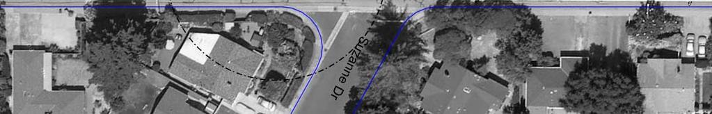
18 Clemo Dr Crosswalk Existing Today
19 Clemo Dr Crosswalk Proposed Crosswalk (Nov 2010) Immediate: Raised Median Ped Activated Flashing Beacon Enhanced Crosswalk markings/signage

")


20 Clemo Dr Crosswalk Proposed Crosswalk (Nov 2010) Immediate: Raised Median Ped Activated Flashing Beacon Enhanced Crosswalk markings/signage
21 Community Input Areas of Concern General Comments Do Not Like Improvements Travel Time on Arastradero Rd Increased Lane Drops/Merges Confusing El Camino Real Traffic Signal Operations Alta Mesa McKellar Lane Left Turn Access Clemo Dr Crosswalk Nov 2010 Coulombe Dr Traffic Signal Modification Response One Year Trial Monitor/Solicit Input Corridor Signage Evaluation City/Caltrans/VTA Coord Signage & Striping Enhanced Crosswalk
22 Coulombe Dr Traffic Signal Modification


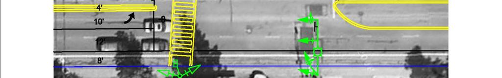

23 Coulombe Dr Traffic Signal Modification
24 Community Input Areas of Concern General Comments Do Not Like Improvements Travel Time on Arastradero Rd Increased Lane Drops/Merges Confusing El Camino Real Traffic Signal Operations Alta Mesa McKellar Lane Left Turn Access Clemo Dr Crosswalk Nov 2010 Coulombe Dr Traffic Signal Modification Donald Dr Terman Rd Traffic Signal Ops Response One Year Trial Monitor/Solicit Input Corridor Signage Evaluation City/Caltrans/VTA Coord Signage & Striping Enhanced Crosswalk Enhanced Signal Phasing
25 Donald Dr Terman Rd Traffic Signal Operations Existing Configuration Today
26 Donald Dr Terman Rd Traffic Signal Operations Option: Extended Left Turn Storage to Terman Dr Helps Eliminate Left Turn Queue Spill over to Westbound Arastradero Rd Traffic King Arthur Ct Shared Left Turn Lane
27 Community Input Areas of Concern General Comments Do Not Like Improvements Travel Time on Arastradero Rd Increased Lane Drops/Merges Confusing El Camino Real Traffic Signal Operations Alta Mesa McKellar Lane Left Turn Access Clemo Dr Crosswalk Nov 2010 Coulombe Dr Traffic Signal Modification Donald Dr Terman Rd Traffic Signal Ops Speeding West of Hubbart Dr Response One Year Trial Monitor/Solicit Input Corridor Signage Evaluation City/Caltrans/VTA Coord Signage & Striping Enhanced Crosswalk Enhanced Signal Phasing Striping & Signal Timing


28 Speeding Vehicle Speed Feedback Signs Option: New raised median island with VSFS facing westbound Arastradero Rd Relocate VSFS from Cemetary to Hubbart Dr facing eastbound Arastradero Rd
29 Community Input Areas of Concern General Comments Do Not Like Improvements Travel Time on Arastradero Rd Increased Lane Drops/Merges Confusing El Camino Real Traffic Signal Operations Alta Mesa McKellar Lane Left Turn Access Clemo Dr Crosswalk Nov 2010 Coulombe Dr Traffic Signal Modification Donald Dr Terman Rd Traffic Signal Ops Speeding West of Hubbart Dr Response One Year Trial Monitor/Solicit Input Corridor Signage Evaluation City/Caltrans/VTA Coord Signage & Striping Enhanced Crosswalk Enhanced Signal Phasing Striping & Signal Timing Vehicle Speed Feedback Signs
30 QUESTIONS/COMMENTS
Los Altos Hills Town Council - June 18, 2015 Palo Alto City Council June 22, AGENDA ITEM #2.B Presentation
 Los Altos Hills Town Council - June 18, 2015 Palo Alto City Council June 22, 2015 AGENDA ITEM #2.B Presentation Previous Presentations Los Altos Hills Town Council in May 2014 and February 2015 Palo Alto
CRESTON ROAD COMPLETE AND SUSTAINABLE STREETS CORRIDOR PLAN
 CRESTON ROAD COMPLETE AND SUSTAINABLE STREETS CORRIDOR PLAN Preferred Plan Community Presentation September 27, 2017 City of El Paso de Robles in partnership with: Local Government Commission, W-Trans,
Foothill Expressway Improvements Between El Monte and San Antonio
 Foothill Expressway Improvements Between El Monte and San Antonio June 29, 2017 - Los Altos Community Meeting Introduction Project Background Agenda Visit Stations: Provide Input and Ask Questions Reconvene:
BD RESOLUTION NO RESOLUTION ADOPTING THE VISION ZERO RAMP INTERSECTION STUDY PHASE 1
 BD00 RESOLUTION NO. - RESOLUTION ADOPTING THE VISION ZERO RAMP INTERSECTION STUDY PHASE [NTIP PLANNING] FINAL REPORT WHEREAS, The Vision Zero Ramp Intersection Study Phase was recommended by Commissioner
MINERAL AVENUE CORRIDOR ASSESSMENT STUDY IMPLEMENTATION STRATEGY
 MINERAL AVENUE CORRIDOR ASSESSMENT STUDY IMPLEMENTATION STRATEGY INTRODUCTION City Personnel Sign-in Sheet Comment Forms Please Write Down Any Feedback INTRODUCTION List of Topics for Presentation Study
El Camino Real Specific Plan. TAC/CAC Meeting #2 Aug 1, 2018
 El Camino Real Specific Plan TAC/CAC Meeting #2 Aug 1, 2018 Land Use Alternatives Goals and Tradeoffs Parks & open space Housing Retail & services Civic spaces Parking Community gathering spaces 3 Alternatives
VEHICLE EMISSIONS REDUCTIONS BASED AT SCHOOLS (VERBS) GRANT APPLICATION FY2012/13 FY2015/16
 GRANT APPLICATION FY2012/13 FY2015/16") VEHICLE EMISSIONS REDUCTIONS BASED AT SCHOOLS (VERBS) GRANT APPLICATION FY2012/13 FY2015/16 SECTION ONE: PROJECT SUMMARY Project Title Arastradero Road Schoolscape Multi use Trail Project Description (Specific
VEHICLE EMISSIONS REDUCTIONS BASED AT SCHOOLS (VERBS) GRANT APPLICATION FY2012/13 FY2015/16 SECTION ONE: PROJECT SUMMARY Project Title Arastradero Road Schoolscape Multi use Trail Project Description (Specific
VT15 / Allen Martin Drive Intersection Scoping Study
 VT15 / Allen Martin Drive Intersection Scoping Study ALTERNATIVES PRESENTATION MEETING DECEMBER 19, 2016 Agenda Study Area Project Background Existing Conditions Identified Issues Proposed Alternatives
122 Avenue: 107 Street to Fort Road
 : 107 Street to Fort Road November 24, 2015 4:30 8:00 p.m. Meeting Purpose Summarize project work completed to date Share results of public input from Phase 1 Share the draft concept plan and proposed
Orange County Rail-Highway Grade Crossing Safety Enhancement Program. City of San Juan Capistrano April 17, 2012
 Orange County Rail-Highway Grade Crossing Safety Enhancement Program City of San Juan Capistrano April 17, 2012 Orange County Rail-Highway Grade Crossing Safety Enhancement Program (OCX) 52 crossings 8
Watertown Complete Streets Prioritization Plan. Public Meeting #1 December 14, 2017
 Watertown Complete Streets Prioritization Plan Public Meeting #1 December 14, 2017 Goals for Public Meeting Overview of MassDOT Complete Streets Funding Program Educate the community on Complete Streets
CITY OF MINNEAPOLIS 26 th St E/W & 28 th St E/W Protected Bikeway. Open House - February 2017
 CITY OF MINNEAPOLIS 26 th St E/W & 28 th St E/W Protected Bikeway Open House - February 2017 2/27/2017 1 Purpose of Meeting Inform: Provide an overview of the project Opportunity to gather feedback/input/observations
Princeton Avenue and Spruce Street Transportation and Site Access Enhancements Project
 Princeton Avenue and Spruce Street Transportation and Site Access Enhancements Project Mercer County Planning Division AECOM Transportation (formerly DMJM Harris) January 29, 2009 Agenda Project Status
EL CAMINO REAL BUS RAPID TRANSIT PROJECT
 EL CAMINO REAL BUS RAPID TRANSIT PROJECT Would upgrade the current 522 Rapid Bus to BRT status by making changes to El Camino Real and The Alameda that make transit FAST, FREQUENT AND RELIABLE and make
Mineral Avenue Corridor Assessment. ITE 2017 Western District Annual Meeting San Diego, CA June 21 st
 Mineral Avenue Corridor Assessment ITE 2017 Western District Annual Meeting San Diego, CA June 21 st Biography - Aaron Heumann, PE, PTOE Currently City of Littleton Transportation Engineering Manager 24
MASSACHUSETTS AVENUE BRIDGE REPLACEMENT PROJECT APRIL 25, 2018
 MASSACHUSETTS AVENUE BRIDGE REPLACEMENT PROJECT APRIL 25, 2018 AGENDA Introductions Project Benefits Progress to Date Schedule for Remaining Work Phase 3 Activities, Impacts & Traffic Detours Phase 4 Activities
@ FRIENDLY ACRES COMMUNITY MEETING
 @ FRIENDLY ACRES COMMUNITY MEETING April 18, 2017 INTRODUCTIONS City of Redwood City TJKM, GATES + Associates Interns Translators AGENDA Presentation Livable Neighborhood Streets Project Background Highlight
Clybourn Ave. Protected Bike Lane Study Halsted St. to Division St.
 Clybourn Ave. Protected Bike Lane Study Halsted St. to Division St. Nathan Roseberry, Senior Engineer Pam Broviak, Project Manager July 24, 2014 Agenda Project Goals Existing Roadway Conditions Traffic
California Department of Transportation, District 4. Sloat Boulevard Project Skyline Blvd. to 19 th Ave. Community Update January 13, 2016
 California Department of Transportation, District 4 Sloat Boulevard Project Skyline Blvd. to 19 th Ave. Community Update January 13, 2016 Agenda Welcome and introductions Project overview, history and
Public Involvement Meeting Tuesday, June 13, Albany Shaker Road Corridor Study
 Public Involvement Meeting Tuesday, June 13, 2017 Albany Shaker Road Corridor Study Agenda / Meeting Outline 1. Introduce the project 2. Complete Streets 3. Share/confirm our findings 4. Your Opinion 5.
About the study. North Milwaukee Ave. Key goals of this study are to: Achieve Vision Zero* by. Harmonize the space and improve walkability
 About the study Key goals of this study are to: North Milwaukee Avenue is a local and regional street for multiple modes of transportation. It is officially zoned and functions as a pedestrian street southeast
Albany Shaker Road Corridor Study Public Meeting # 2
 Albany Shaker Road Corridor Study Public Meeting # 2 Scope / Meeting Purpose This project is a CDTC Linkage Study. The Linkage Program is designed to implement the adopted planning and investment principles
Draft Final Report: South Palo Alto School Commute Safety Study
 Draft Final Report: South Palo Alto School Commute Safety Study Prepared for: The City of Palo Alto 1021-1839 F EHR & P EERS T R A N S P O R TAT I O N 3685 Mt. Diablo Blvd. #301 Lafayette, CA 94549 925-284-3200
2014/2015 BIKE ROUTE PLAN 83 AVENUE PROTECTED BIKE LANE
 About the Project 2014/2015 BIKE ROUTE PLAN The City of Edmonton is planning a major bike route on the south side of Edmonton. This bike route is one part of a plan to provide citizens with transportation
City of Wilsonville 5 th Street to Kinsman Road Extension Project
 City of Wilsonville 5 th Street to Kinsman Road Walking Tour & Neighborhood Workshop Summary Report Public Outreach Overview On July 18 th, 2017, the City of Wilsonville hosted a neighborhood walking tour
Complete Streets Chicago: Data Driven Design. Luann Hamilton Deputy Commissioner
 Complete Streets Chicago: Data Driven Design Luann Hamilton Deputy Commissioner AGENDA Chicago s goals Complete Streets & Sustainable Infrastructure Guides Data-Driven Planning Setting goals Scoping/research
Project Goal and Description. Why Broadway? Broadway SFMTA.COM/BROADWAY. The goal of the Broadway Safety Improvement
 PROJECT OVERVIEW Project Goal and Description The goal of the Broadway Safety Improvement d St Van Ness Ave Project is to improve safety and comfort for all who Franklin St Hyde St Octavia St Gough St
2014/2015 BIKE ROUTE PLAN 83 AVENUE PROTECTED BIKE LANE
 About the Project The City of Edmonton is planning a major bike route on the southside of Edmonton. The Strathcona Bike Route will connect the communities of Strathcona, Garneau and the University area,
43 rd Avenue, Skillman Avenue Protected Bike Lanes
 43 rd Avenue, Skillman Avenue Protected Bike Lanes Presented to Queens Community Board 2 Transportation Committee - November 6, 2017 43 rd Avenue, Skillman Avenue: Presentation Overview Background Project
Freeway ramp intersection study
 Freeway ramp intersection study Supporting Vision Zero: Zero traffic deaths in San Francisco by 2024 Study Goals: Primary Improve Safety Improve Accessibility Secondary Provide Efficient Circulation Accommodate
Chicago Safe Routes to School Safe Routes to High School (SRTS/SRTHS)
") Chicago Safe Routes to School Safe Routes to High School (SRTS/SRTHS) Marshall Community High School and Faraday Elementary School Recommended Improvements Agenda Goals Related Programs Project Location/Area
Chicago Safe Routes to School Safe Routes to High School (SRTS/SRTHS) Marshall Community High School and Faraday Elementary School Recommended Improvements Agenda Goals Related Programs Project Location/Area
Summary: Mercer County Princeton Avenue & Spruce Street Study January 2009
 Summary: Several recent studies have assessed potential development and redevelopment opportunities in the Mercer Crossing area of Trenton, Ewing, and Lawrence. This Princeton Avenue and Spruce Street
J Street and Folsom Boulevard Lane Conversion Project (T ) Before and After Traffic Evaluation
 Before and After Traffic Evaluation") J Street and Folsom Boulevard Lane Conversion Project (T15125400) Before and After Traffic Evaluation Prepared by Transportation Division June 2014 Executive Summary On February 12, 2013, the City of Sacramento
J Street and Folsom Boulevard Lane Conversion Project (T15125400) Before and After Traffic Evaluation Prepared by Transportation Division June 2014 Executive Summary On February 12, 2013, the City of Sacramento
Pine Hills Road Pedestrian/Bicycle Safety Study Board of County Commissioners Work Session
 Pine Hills Road Pedestrian/Bicycle Safety Study Board of County Commissioners Work Session February 20, 2018 Meeting Agenda Study Overview Existing Conditions Access Management Potential Gateway Features
September 20, 2016 L Taraval Rapid Project SFMTA Board of Directors Meeting
 September 20, 2016 L Taraval Rapid Project SFMTA Board of Directors Meeting WHY TARAVAL STREET L TARAVAL PROJECT GOALS 1. Improve state of good repair of our transit system Track and overhead replacement
Governance and Priorities Committee Report For the July 2, 2015 Meeting
 CITY OF VICTORIA For the July 2, 2015 Meeting To: Governance and Priorities Committee Date: From: Subject: Brad Dellebuur, A/Assistant Director, Transportation and Parking Services Executive Summary The
CITY OF TAMARAC NOTICE OF WORKSHOP MEETING CITY COMMISSION OF TAMARAC, FL City Hall - Conference Room 105 June 20, 2016
 CITY OF TAMARAC NOTICE OF WORKSHOP MEETING CITY COMMISSION OF TAMARAC, FL City Hall - Conference Room 105 June 20, 2016 CALL TO ORDER: 9:30 a.m. ROLL CALL: PLEDGE OF ALLEGIANCE: Vice Mayor Diane Glasser
COMMUNITY MEETING AGENDA
 COMMUNITY MEETING AGENDA Welcome and Introductions SAFE Presentation Project Presentation Priorities Feedback Next Steps Q&A Santa Cruz Avenue Corridor Study 1 Santa Cruz Avenue Corridor Study Community
Riverside Drive Complete Streets Project 3 rd Community Meeting. March 26, 2015
 Riverside Drive Complete Streets Project 3 rd Community Meeting March 26, 2015 Providing Feedback Sign-In with contact information for future updates Complete questionnaire provided tonight Complete comment
CITY OF OAKLAND. 27th Street Bikeway Feasibility and Design. Final Report (v3) March 23, Kimley-Horn and Associates, Inc.
 March 23, Kimley-Horn and Associates, Inc.") CITY OF OAKLAND 27th Street Bikeway Feasibility and Design Final Report (v3) March 23, 2007 PREPARED BY: Kimley-Horn and Associates, Inc. Table of Contents 1. Introduction 3 2. 27 th Street/Bay Place Corridor
CITY OF OAKLAND 27th Street Bikeway Feasibility and Design Final Report (v3) March 23, 2007 PREPARED BY: Kimley-Horn and Associates, Inc. Table of Contents 1. Introduction 3 2. 27 th Street/Bay Place Corridor
Committed to Service
 Committed to Service Paul Woods, President Rebecca W. Arnold, Vice President Sara M. Baker, Commissioner Jim D. Hansen, Commissioner Kent Goldthorpe, Commissioner March 14, 2017 Planning and Programming
City of Scotts Valley CITY COUNCIL STAFF REPORT
 DATE: April 19, 2017 City of Scotts Valley CITY COUNCIL STAFF REPORT AGENDA ITEM 2 DATE: 4-19-2017 TO: FROM: APPROVED: SUBJECT: Honorable Mayor and City Council Scott Hamby, Public Works Director Jenny
Upper Market Street Bike Lane Project
 Upper Market Street Bike Lane Project 17th Street to Octavia Boulevard 6 30 2010 SAN FRANCISCO, CALIFORNIA Agenda San Francisco & Sustainable Transportation Project Goals Outreach & Coordination Project
Dr. M.L. King, Jr. Street North Complete Streets Resurfacing Opportunities HOUSING, LAND USE, AND TRANSPORTATION COMMITTEE MARCH 22, 2018
 Dr. M.L. King, Jr. Street North Complete Streets Resurfacing Opportunities HOUSING, LAND USE, AND TRANSPORTATION COMMITTEE MARCH 22, 2018 What s Happening The City plans to mill and resurface Dr. M.L.
Caltrans Sloat Boulevard Pedestrian Safety Project Response to Community Questions, Comments & Concerns
 Caltrans Sloat Boulevard Pedestrian Safety Project Response to Community Questions, Comments & Concerns Revised: May 10, 2016 The California Department of Transportation (Caltrans) is planning various
Lawrence Avenue Streetscape Concepts August 30, 2011
 Lawrence Avenue Streetscape Concepts August 30, 2011 Neighborhood Context Phase II: River to Western Ave. Phase I: Western Ave. to Clark St. Key Map Lawrence Ave. Existing Streetscape Conditions East of
Public Information Centre
 WELCOME Public Information Centre Father Tobin Road Lougheed Middle School - Library Wednesday November 7, 2012 7:00 p.m.to 9:00 p.m. Please sign in Neighbourhood Traffic Calming Guide Background The City
Saskatchewan Drive Roadway Rehabilitation and Shared-Use Path Widening
 Saskatchewan Drive Roadway Rehabilitation and Shared-Use Path Widening We are here today to present the draft plan for the Saskatchewan Drive Roadway Rehabilitation and Shared-Use Path Widening project
West Capitol Avenue Road Rehabilitation and Safety Enhancement Project
 West Capitol Avenue Road Rehabilitation and Safety Enhancement Project Stakeholder Focus Group Meeting #2 Tuesday, August 28, 2018 7:00 8:00 a.m. West Sacramento City Hall 1110 West Capitol Avenue, West
CITY OF OTTAWA ROADWAY MODIFICATION APPROVAL UNDER DELEGATED AUTHORITY
 RMA-2015-ATM-038 CITY OF OTTAWA ROADWAY MODIFICATION APPROVAL UNDER DELEGATED AUTHORITY DATE: April 22, 2015 SUBJECT Approval of Roadway Modifications Recommended through an Area Traffic Management Study
Toronto and East York Community Council. Director, Transportation Services, Toronto and East York District
 No Turn on Red Regulations STAFF REPORT ACTION REQUIRED Date: June 1, 2010 To: From: Toronto and East York Community Council Director, Transportation Services, Toronto and East York District Wards: Trinity
Safe Routes to School (SRTS) Improvements for Bishop s Peak & Pacheco Elementary Meeting #2 Summary
 Improvements for Bishop s Peak & Pacheco Elementary Meeting #2 Summary") Safe Routes to School (SRTS) Improvements for Bishop s Peak & Pacheco Elementary Meeting #2 Summary Overview. On March 8 th, 2017, community residents attended the second in a series of neighborhood meetings
Safe Routes to School (SRTS) Improvements for Bishop s Peak & Pacheco Elementary Meeting #2 Summary Overview. On March 8 th, 2017, community residents attended the second in a series of neighborhood meetings
Broad Street Bicycle Boulevard Design Guidelines
 Broad Street Bicycle Boulevard Design Guidelines Building from the strategies introduced in the 2013 Bicycle Transportation Plan and community input received thus far, City Transportation Staff have identified
Richmond-Adelaide Cycle Tracks
 Public Drop-In Event Richmond-Adelaide Cycle Tracks June 25, 2018 12:00 p.m. 3:00 p.m. 4:30 p.m. 7:30 p.m. Metro Hall, Rotunda 55 John Street 1 Purpose of Event In Scope Communicate an update about the
Meade Street Bridge Design Alternative Study
 Meade Street Bridge Design Alternative Study Preferred Alternative Presentation Stakeholder Meeting #3 June 23, 2011 Presented by: Dan Biggs, RLA Meeting Agenda Purpose: 1. Review Meeting #2 Feedback 2.
TRAFFIC ACTION PLAN. Laurie Meadows Neighborhood CITY OF SAN MATEO
 TRAFFIC ACTION PLAN Laurie Meadows Neighborhood CITY OF SAN MATEO Draft January 2017 Table of Contents Introduction... 2 The Traffic Forum Process... 5 Neighborhood Traffic Issues... 7 Neighborhood Recommendations
MCARTHUR AVENUE AS WE HEARD IT REPORT CYCLING LANES. City of Ottawa Transportation Services. Photo: istock
 MCARTHUR AVENUE CYCLING LANES Photo: istock AS WE HEARD IT REPORT City of Ottawa Transportation Services CONTENTS Background...1 Consultation Activities Summary...1 Public Commentary Questionnaire Results...2
Average Delay/Vehicle (sec/veh) Signalized. Unsignalized Intersection
 Signalized. Unsignalized Intersection") Attachment: Traffic Analysis Results Traffic simulation modeling analysis was completed for Santa Cruz Ave from Alameda De Las Pulgas to Junipero Serra Blvd. Analysis was performed for existing conditions
Attachment: Traffic Analysis Results Traffic simulation modeling analysis was completed for Santa Cruz Ave from Alameda De Las Pulgas to Junipero Serra Blvd. Analysis was performed for existing conditions
Supervisor Cook Announces Final Plans for Braddock Road Improvement Project
 Supervisor Cook Announces Final Plans for Braddock Road Improvement Project After more than two years of study and significant community input, I am pleased to announce the final plans for the Braddock
» Draft Recommendations» Discussion» Next Steps. Plan for Walking and Biking
 SAC Meeting Plan #3 for September Walking and 12, Biking 2018 » Draft Recommendations» Discussion» Next Steps Plan for Walking and Biking » Stakeholder and Public Outreach» Background data collection and
@ North Fair Oaks COMMUNITY MEETING
 @ North Fair Oaks COMMUNITY MEETING April 18, 2017 INTRODUCTIONS City of Redwood City TJKM, GATES + Associates Interns Translators AGENDA Presentation Livable Neighborhood Streets Project Background Highlight
5. RUNNINGWAY GUIDELINES
 5. RUNNINGWAY GUIDELINES These guidelines should be considered collectively when making runningway decisions. A runningway is the linear component of the transit system that forms the right-of-way reserved
Lincoln Way Multimodal Safety and Operations Study. City and University Summary Presentation
 Lincoln Way Multimodal Safety and Operations Study City and University Summary Presentation February 27, 2018 Agenda Introductions Study Overview: Phase 1 - Discovery Phase 2 Improvement Recommendations
Poplar Avenue, US101 to Humboldt, Traffic Improvements Small Group Reports Community Workshop May 20, 2010
 Poplar Avenue, US101 to Humboldt, Traffic Improvements Small Group Reports Community Workshop May 20, 2010 Group 1 Facilitated by Ken Chin, PUBLIC WORKS Latino population Schools SEMIs/Commercial Burlingame
THE NACTO MANUALS AND DESIGNING FOR VISION ZERO ZAKI MUSTAFA SHIRLEY ZAMORA
 THE NACTO MANUALS AND DESIGNING FOR VISION ZERO ZAKI MUSTAFA SHIRLEY ZAMORA NACTO Design Guides 2 City of Los Angeles Vision Zero 3 Vision Zero Roscoe Boulevard Corridor SHIRLEY ZAMORA TRANSPORTATION ENGINEERING
Complete Street Analysis of a Road Diet: Orange Grove Boulevard, Pasadena, CA
 Complete Street Analysis of a Road Diet: Orange Grove Boulevard, Pasadena, CA Aaron Elias, Bill Cisco Abstract As part of evaluating the feasibility of a road diet on Orange Grove Boulevard in Pasadena,
Broadway Complete Streets Project
 Broadway Complete Streets Project Megan Johnson, P.E. Associate Civil Engineer James Pangburn, P.E. Consultant Project Manager After the construction of the highway system, Broadway was cut off
AGENDA ITEM G-2 Public Works
 AGENDA ITEM G-2 Public Works STAFF REPORT City Council Meeting Date: 12/6/2016 Staff Report Number: 16-214-CC Regular Business: Approve the Oak Grove University Crane Bike Improvement Concept Plan, authorize
MEMORANDUM. Charlotte Fleetwood, Transportation Planner
 MEMORANDUM Date: Updated August 22, 2017 To: Organization: Charlotte Fleetwood, Transportation Planner Boston Transportation Department From: Jason DeGray, P.E., PTOE, Regional Director of Engineering
CITY OF PORTSMOUTH PLANNING DEPARTMENT
 CITY OF PORTSMOUTH PLANNING DEPARTMENT MEMORANDUM TO: JOHN P. BOHENKO, CITY MANAGER FROM: JULIET T.H. WALKER, PLANNING DIRECTOR SUBJECT: BICYCLE / PEDESTRIAN PLAN PROGRESS UPDATE DATE: 3/13/2018 Background
Mandan Commission Meeting August 2, 2016 Mandan City Hall
 Mandan-Bismarck Corridor Improvement Study Mandan Commission Meeting August 2, 2016 Mandan City Hall 2014 HDR, Inc., all rights reserved. Mandan Corridors Study Schedule 2015 2016 Study Kick Off August
Lincoln Avenue Road Diet Trial
 Lincoln Avenue Road Diet Trial Data Collection Report June 1, 2015 Department of Transportation Table of Contents I. Introduction...... 3 II. Data Collection Methodology & Results...... 5 A. Traffic Volume
North Avenue Corridor Study
 North Avenue Corridor Study City Council October 6, 2014 Presentation Outline Project Initiation & Process Corridor Conditions & Issues Vision & Goals Concept Development - Development/Evaluation Implementation
TOWN OF MORAGA MORAGA WAY AND CAMINO PABLO/CANYON ROAD IMPROVEMENTS Town Council Meeting March 13, 2019
 TOWN OF MORAGA MORAGA WAY AND CAMINO PABLO/CANYON ROAD IMPROVEMENTS Town Council Meeting March 13, 2019 1 Edric Kwan, Public Works Director Josh Peterman, Principal, Fehr and Peers Shawn Knapp, Senior
Designing for Pedestrian Safety
 Designing for Pedestrian Safety Road Diets Presented by: Peter Lagerwey Senior Planner, Toole Design Group November 3, 2010 Before After Learning Objectives At the end of this module, you will be able
Draft North Industrial Area-Wide Traffic Plan
 Summary of North Industrial and Hudson Bay Industrial Recommended Improvements Table 1. Summary of s Item Location 1 2 3 4 5 6 7 8 9 10 11 12 Millar Ave north of 51st St Super 8 Motel back lane 400 Block
Community Task Force March 14, 2018
 Community Task Force March 14, 2018 Welcome and Introductions Project Partners Regional Transportation District (RTD) City of Aurora Colorado Department of Transportation (CDOT) Denver Regional Council
PEDESTRIAN ACCOMMODATIONS DPS 201 AT INTERCHANGES
 PEDESTRIAN ACCOMMODATIONS DPS 201 AT INTERCHANGES UNDERSTANDING THE ISSUES Intersections of freeway ramp terminals at crossroads are the most critical components of an interchange Challenge: balance mobility
MOBILITY WORKSHOP. Joint City Council and Transportation Commission May 5, 2014
 MOBILITY WORKSHOP Joint City Council and Transportation Commission May 5, 2014 Review of General Plan M-1 Develop world-class transit system M-3 Maintain/enhance pedestrian-oriented City M-4 Create comprehensive
Bike Planning: A New Day
 Bike Planning: A New Day Josh Sikich, AICP, LEED AP Chicago Office Director Alta Planning + Design 312-265-0628 joshuasikich@altaplanning.com cities of all sizes are changing Illinois Bike Summit October
Balancing Operation & Safety for Motorized and Non-Motorized Traffic
 Balancing Operation & Safety for Motorized and Non-Motorized Traffic Brian Willham, PE, PTOE Iowa Director - MOVITE June 30, 2014 Learning Objectives: When & Why should we measure the performance of complete
US 278 Corridor Concept Presentation. Avondale Estates Intersection Improvement/Roundabout and Road Diet Feasibility Study March 19, 2015
 US 278 Corridor Concept Presentation Avondale Estates Intersection Improvement/Roundabout and Road Diet Feasibility Study March 19, 2015 Thanks to our Partners Atlanta Regional Commission Georgia Department
Tunnel Reconstruction South 5 th Street Association October 16, 2018
 Tunnel Reconstruction South 5 th Street Association October 16, 2018 Reconstructing the Tunnel 2 Service During Tunnel Reconstruction April 2019 through July 2020 3 Projected Cross River Travel Paths of
Columbia Pike Implementation Team (CPIT) Meeting
 Meeting") Columbia Pike Implementation Team (CPIT) Meeting November 30, 2010 Agenda Introductions / Purpose of Meeting Review of project goals Multimodal project: 10% street design between the curbs Discussion Multimodal
Columbia Pike Implementation Team (CPIT) Meeting November 30, 2010 Agenda Introductions / Purpose of Meeting Review of project goals Multimodal project: 10% street design between the curbs Discussion Multimodal
Feasibility Study of Pedestrian Crossings Along Route 7, East of Cascades Parkway and West of Dranesville Road. October 3, 2017
 Feasibility Study of Pedestrian Crossings Along Route 7, East of Cascades Parkway and West of Dranesville Road October 3, 2017 Study Area (area within a ¼-mile radius of the study intersections) Route
Central Avenue Bikeway Traffic and Safety Impact Assessment
 FEBRUARY 2018 Lead Agency: San Diego Association of Governments (SANDAG) 401 B Street, Suite 800 San Diego, CA 92101 Contact: Chris Carterette, AICP, Project Manager 619.699.7319 chris.carterette@sandag.org
Queensboro Bridge Bus Priority Study: Summary of Recommendations. Presentation to Manhattan Community Board 8 May 4, 2011
 : Summary of Recommendations Presentation to Manhattan Community Board 8 May 4, 2011 1 Overview Study Goal: Identify cost-effective ways to improve bus speed and reliability for local and express buses
Citizen Advisory Group Meeting #8 May 5, Welcome. Today s meeting will focus on: Land Use & Transportation CHARLOTTEPLANNING.
 Citizen Advisory Group Meeting #8 May 5, 2010 Welcome. Today s meeting will focus on: Land Use & Transportation CHARLOTTEPLANNING.ORG Meeting Agenda Handouts: o Meeting Agenda o Summary of East Seventh
EL CAMINO REAL BUS RAPID TRANSIT (BRT) PROJECT
 PROJECT") Agenda Item #4.2 EL CAMINO REAL BUS RAPID TRANSIT (BRT) PROJECT VTA BOARD WORKSHOP MAY 1, 2015 ABOUT THIS PRESENTATION CONTEXT Existing conditions and planning for growth WHAT IS THE PROJECT? Project alternatives
Agenda Item #4.2 EL CAMINO REAL BUS RAPID TRANSIT (BRT) PROJECT VTA BOARD WORKSHOP MAY 1, 2015 ABOUT THIS PRESENTATION CONTEXT Existing conditions and planning for growth WHAT IS THE PROJECT? Project alternatives
City of El Cerrito San Pablo Avenue Specific Plan. Capital Improvement Program
 City of El Cerrito San Pablo Avenue Specific Plan Capital Improvement Program May 2015 San Pablo Avenue Intersection Improvements San Pablo Avenue and Hill Street/Eastshore Boulevard Background Existing
Lake Whitney Elementary School
 Lake Whitney Elementary School SCHOOL ROUTE PLAN For LAKE WHITNEY ELEMENTARY SCHOOL LOCATION 18 ORANGE COUNTY Prepared for: ORANGE COUNTY SCHOOL ASSESSMENT PROGRAM ORANGE COUNTY PUBLIC WORKS Traffic Engineering
Forest Hills Improvement Initiative
 Forest Hills Improvement Initiative Transportation Action Plan Short Term Recommendations ONLY Final Draft as of April 30, 2008 For Community Review and Feedback Prepared for: The City of Boston Boston
CITY OF LOS ANGELES INTER-DEPARTMENTAL MEMORANDUM
 CITY OF LOS ANGELES INTER-DEPARTMENTAL MEMORANDUM Date: April 1, 219 To: Honorable City Council c/o City Clerk, Room 395, City Hall Attention: Honorable Mike Bonin, Chair, Transportation Committee From:
Bicycle + Pedestrian Connectivity Gap Analysis
 Accelerated Bridge Program Bicycle + Pedestrian Connectivity Gap Analysis Tuesday, October 11 Shriners Hospital, Boston 6:30-8:00 PM Thursday, October 13 Community Rowing, Brighton 6:30-8:00 PM Tuesday,
Military Road Safety Improvements
 Military Road Safety Improvements 26 th Road North to 31 st Street North SUMMARY OF DATA REVIEW AND PRELIMINARY RECOMMENDATIONS Prepared for: Department of Environmental Services Traffic Engineering and
City of Sammamish. Welcome. Issaquah-Fall City Road Improvements Project Phase I Design: 242nd Avenue SE to Klahanie Drive SE
 Welcome Welcome to the third community meeting for the Issaquah-Fall City Road Improvements Project. AGENDA 6:00 p.m. Welcome and sign-in 6:10 p.m. Presentation 6:50 p.m. Open house Learn about the roadway
I-105 Corridor Sustainability Study (CSS)
") I-105 Corridor Sustainability Study (CSS) Metro Streets and Freeways Subcommittee March 21, 2019 Gary Hamrick Cambridge Systematics, Inc. I-105 CSS Project History & Background Funded by Caltrans Sustainable
I-105 Corridor Sustainability Study (CSS) Metro Streets and Freeways Subcommittee March 21, 2019 Gary Hamrick Cambridge Systematics, Inc. I-105 CSS Project History & Background Funded by Caltrans Sustainable
REQUIREMENTS FOR TRAFFIC CONTROL PLAN SUBMISSION
 REQUIREMENTS FOR TRAFFIC CONTROL PLAN SUBMISSION A draft traffic control plan, consistent with the following applicable conditions, must be included in every permit application submitted to the City of
Lessons Learned from Cycle Tracks (Class IV Bikeways) Design Practice
 Design Practice") Lessons Learned from Cycle Tracks (Class IV Bikeways) Design Practice By: Min Zhou, P.E., Principal/Vice President KOA Corporation 1 What is a Cycle Track (Class IV) TYPICAL BIKEWAY CLASSIFICATION CLASS
Lessons Learned from Cycle Tracks (Class IV Bikeways) Design Practice By: Min Zhou, P.E., Principal/Vice President KOA Corporation 1 What is a Cycle Track (Class IV) TYPICAL BIKEWAY CLASSIFICATION CLASS
Reference number /VP. Lafayette Downtown Congestion Study - Additional Traffic Analysis
 To James Hinkamp and Tony Coe, City of Lafayette Date January 19, 2017 Copies Reference number 243381/VP From Michael Iswalt and Vanessa Peers File reference 4-05 Subject Lafayette Downtown Congestion