A Vision for Athens: Transportation Plan. By Mac Martin, AICP City Planner
|
|
|
- Octavia Dean
- 6 years ago
- Views:
Transcription


1 A Vision for Athens: Transportation Plan By Mac Martin, AICP City Planner
2 Transportation Plan Introduction Background Existing Conditions The Plan / Implementation Strategy Conclusion
3 Introduction This plan shall serve as the transportation component of the overall master planning effort of the City of Athens, Alabama entitled A Vision for Athens Initial step was the Future Land Use and Development Plan, adopted in December 2013
4 Introduction The transportation component is meant to serve as an additional step in fulfilling the duty conveyed upon the City and its Planning Commission to make and adopt a master plan for the physical development of the municipality and, more specifically, to make the plan with the general purpose of guiding and accomplishing a coordinated, adjusted, and harmonious development of the municipality in accordance with present and future needs, best promote health, safety, morals, order, convenience, prosperity, and general welfare including, among other things, adequate provision for traffic, according to Sections through of the Code of Alabama 1975, as amended.
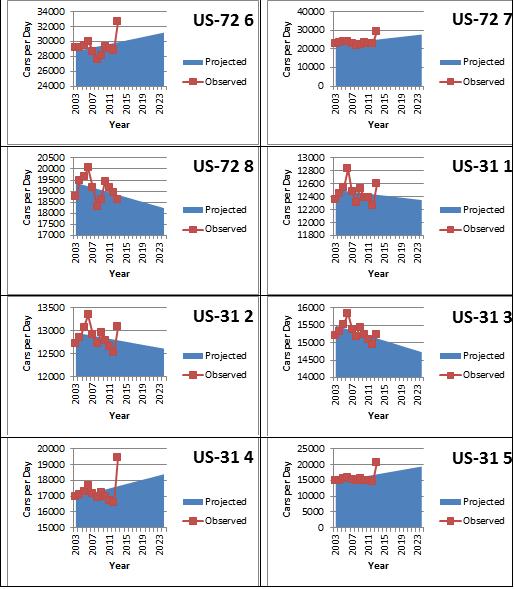
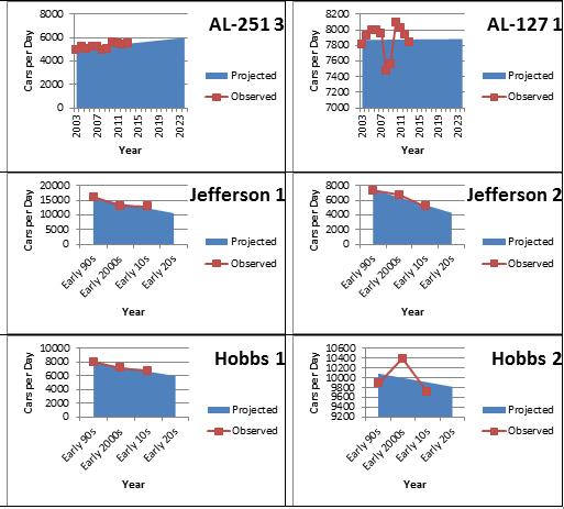
5 Introduction The purposes of the transportation component are to assess the effectiveness of the existing transportation system, considering the present land uses and transportation network, and to develop a transportation plan that will mitigate current and future deficiencies, increase mobility, support the FLUP, and create a safe and efficient means of travel for the future. The plan has a 10 to 20 year outlook. The plan takes a more conservative approach than the 2003 plan.
6 Background Athens is fortunate to have good access to a variety of modes of transportation (land, air, water). With such connectivity and access to the greater transportation network, Athens is poised to be a relevant option for continued residential, commercial, and industrial growth for the foreseeable future. As we continue to grow, our network will need to keep pace.
7 Current Conditions

8
9 Functionality of Road Classifications. Source: ALDOT Access Management Manual, 2014.
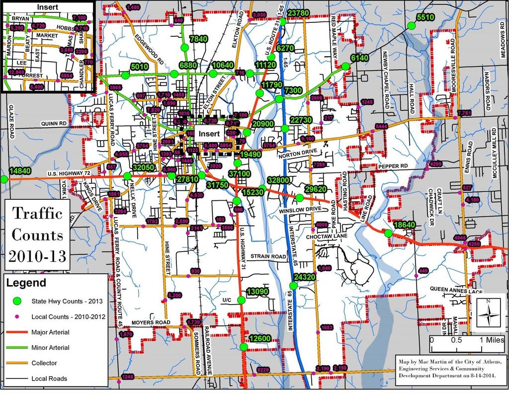
10

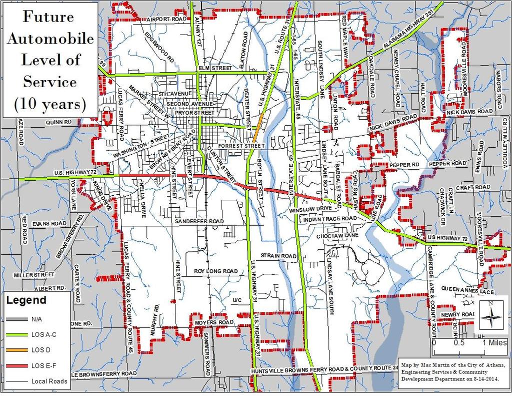
11 Level of Service (LOS) Automobile Level of Service Scale (LOS). Source: Highway Capacity Manual, Transportation Research Board
12 Level of Service (LOS)

13 Level of Service (LOS)

14 Level of Service (LOS)

15 Level of Service (LOS)

16 Level of Service (LOS)
17
18 Level of Service (LOS) The only thoroughfare currently registering a failing LOS grade is US 72, from Lindsay Lane to Lucas Ferry Road. During the time spent in the field, the author observed that traffic on US 72 generally increases throughout the day, becoming heaviest from the time schools adjourn through the evening commute. Traffic flow was largely uninterrupted during the morning. Traffic became heavier from lunchtime on, the flow of traffic became increasingly interrupted. This was particularly the case along portions of US 72 where the number of signalized intersections increases and distances between them decrease. The traffic signals, excessive numbers of access points, inadequate or no turn lanes seemed to be primary factors in stymieing traffic flow.
19 US 72 Signals Each intersection operates on an independent loop system. Timing of the signals remains under the explicit control of ALDOT The last time an exercise was conducted to synchronize the timing of the signals on US 72 was in The current programming of the signals does not take into account the comprehensive nature of present traffic conditions along the thoroughfare.
20 Signals on Other Streets
21 Affordability and Automobile Dependency For the average American family, the largest expense beyond housing is transportation. Transportation costs consume 25% of an average household s income in the United States living in automobile dependent communities. Additionally, those same families are spending, on average, 32% of their income on housing, leaving a mere 43% of disposable income for all other family expenses (FHWA 2014). The H+T (Housing plus Transportation) Affordability Index states that a community is considered affordable when housing and transportation costs do not exceed 45% of a household s income

22 Affordability and Automobile Dependency
")
23 Percent Alternative Transportation Modes Percent of Person Trips by Mode of Transportation 100% 90% Other Walking 80% 70% 60% 50% Public Transport Private Car 40% 30% 20% 10% 0% Source: 2009 National Household Travel Survey (NHTS) Year

24 Alternative Transportation Modes Percent Share of Trip Purposes by Private Car 2% 25% 17% 3% To/ From Work Work-Related Business 8% Family/ Personal Errands School or Church 45% Social and Recreational Other * Family/Personal Errands includes personal business, shopping, and medical/dental.
25 Bike and Pedestrian LOS
26 Bike and Pedestrian LOS

27 Bike and Pedestrian LOS
28 Safety and Efficiency Safety and efficiency are the City s primary concerns. Safety and efficiency can be addressed in large part by efforts to improve the LOS. According to ALDOT, allowing roadways to operate according to their functional classification increases efficiency and enhances safety for all roadway users
29 Safety The University of Alabama s Center for Advanced Public Safety reports a total of 2,324 automobile accidents within the city of Athens from January 2009 to December 2013

30 Severity of Crashes

31 Locale of Crashes

32 Time of Crashes

33 Crashes by Road Classification
34 Crashes by Road Classification
35 Conflict Points by Intersection Type

36 Concerns at Specific Locations Intersection of US 72, Athens-Limestone Blvd., and Audubon Ln.

37 Concerns at Specific Locations US 72 underpass at CSX railroad, turn lane onto Jefferson St. South.

38 Concerns at Specific Locations Turn lane length at Exit 351

39 Concerns at Specific Locations Intersection of US 72 and Cambridge Ln.

40 Concerns at Specific Locations Intersection of Nick Davis Rd. and Oakdale Rd.

41 Concerns at Specific Locations Intersection of US 72 and Mooresville Rd.

42 Concerns at Specific Locations Access management along retail corridor of US 72 excessive driveways.

43 Concerns at Specific Locations Unwarranted median crossings

44 Concerns at Specific Locations Pedestrians crossing Swan Creek bridge on Elm St./AL 99.

45 Concerns at Specific Locations 4-lane undivided roadways.
46 Current Projects Old Decatur Road/French Farms Blvd Bridge ATRIP Especially Forrest Street Bridge Replacement*** Will push additional traffic onto Lindsay Ln, AL 251, US 72 Local Street Paving Forrest Street and Lindsay Lane Sidewalk General Sidewalk Maintenance These projects are expected to cover the majority of transportation funds available to the City for the next couple of years
47 THE PLAN AND IMPLEMENTATION STRATEGY
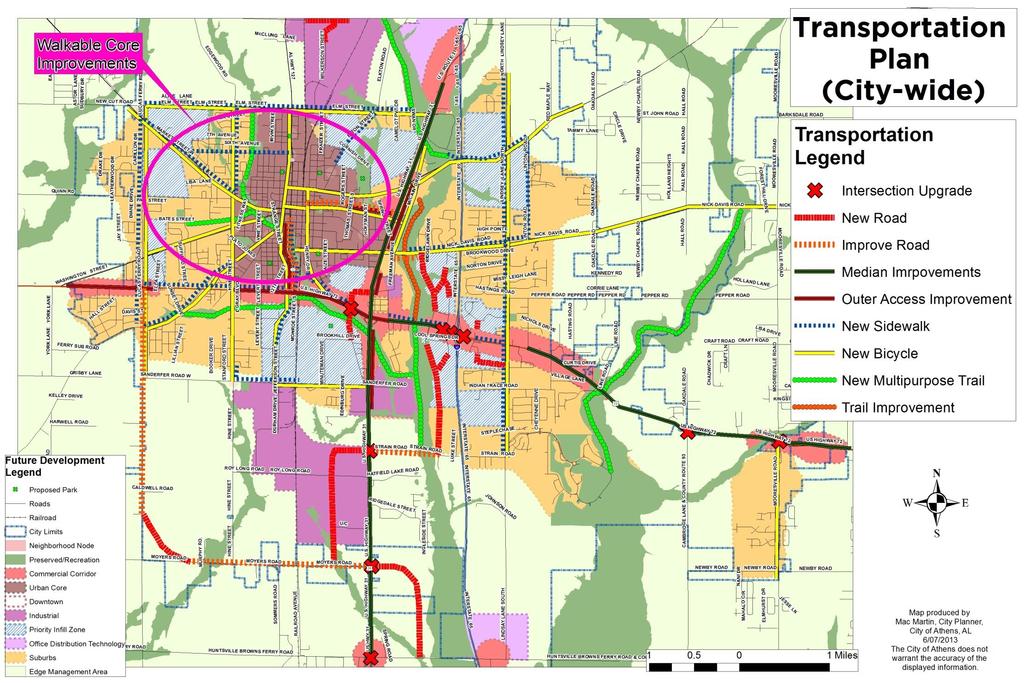
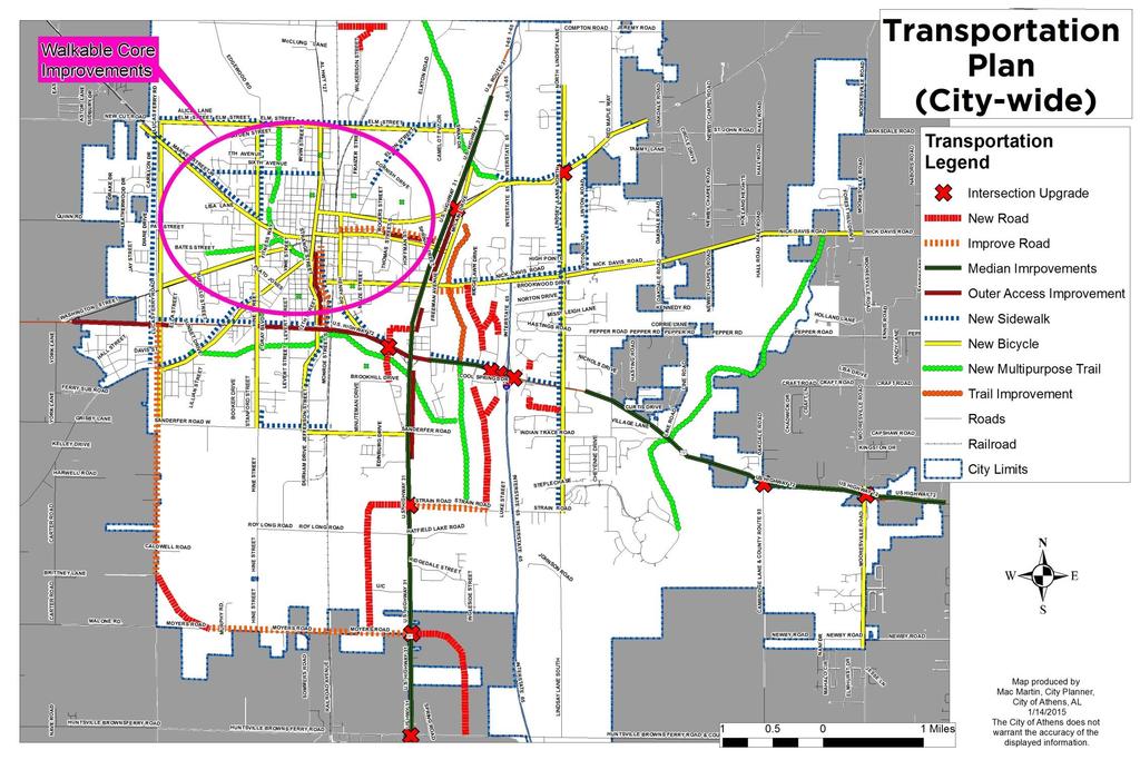
48 Vision Statement We, the City of Athens, desire to develop a transportation network comprised of a variety of modes that allow people and goods to safely and efficiently travel around and through the community.
49
50
51 Goals and Objectives Goal #1: Improve the safety and efficiency of the existing network.
52 Objective: Address pressing safety concerns identified in the field. Objective: Install larger street signs for cross streets at intersections along arterials. Objective: Redesign and reconfigure intersections identified as needing improvements in alignment and traffic movement. Note: More extensive studies need to be conducted for each intersection prior to designing and constructing improvements. US 72 and Mooresville Rd. US 72 and Cambridge Ln. US 72 and I-65, Exit 351 Consider: Converting the interchange into a Single Point Urban Interchange (SPUI).
53 FHWA Diagram of a SPUI

54 SPUI constructed outside of Boise, Idaho

55 Landscaping and brickwork at a SPUI in Madison, Mississippi

56 Monument in ramp median at a SPUI in Franklin, TN
57 Objective: Re-design and reconfigure intersections identified as needing improvements in alignment and traffic movement. Note: More extensive studies need to be conducted for each intersection prior to designing and constructing improvements. Continued US 72 and Audubon Ln/Athens-Limestone Blvd. US 72 and Athens-Limestone Blvd./Braly Blvd. US 72 and French Farms Blvd. US 31 and AL 251*** Lindsay Ln and AL 251 *** US 31 and Strain Rd. US 31 and Moyers Rd. US 31 and Huntsville-Brownsferry Rd. (Currently in queue). Nick Davis Rd. and Oakdale Rd.
58 Objective: Improve traffic signal coordination along US 72. Time signals along US 72 to permit traffic groupings to pass through the city with minimal interruption. Program signals at intersections with lower traffic counts to caution setting (flashing yellow on US 72, flashing red on secondary road) after primary travel hours in the evening. Program them to return to normal phasing before morning primary travel times. Implement newer signalization techniques, such as giving dedicated left turn traffic a flashing caution (yellow arrow) signal

59 Typical Position and Arrangements of Separate Signal Faces with Flashing Yellow for Protected/Permissive Mode and Protected Only Mode Left Turns
60 Objective: Improve and preserve traffic flow along US 72 and US 31 through access and traffic conflict management Reduce unwarranted median crossovers and driveways. Full access should be limited to signalized intersections wherever possible. Alternative intersection designs should be implemented at intersections not warranting signals. Left turn movements should be channelized with deceleration lanes. U-turn facilities should be provided to allow access to properties fronting the roadway where medians are closed and to improve safety and traffic flow at non-signalized intersections, particularly when visibility is poor.

61 Alternative intersection design with restricted and channelized left turn movements. This design is usually accompanied by a designed U-Turn opportunity
62 Conventional median opening with left-turn lanes and loons at three-leg intersection
")
63 Example of a Michigan Right-Turn, U-Turn (RTUT) intersection
64 Goals and Objectives Goal #2: Expand the transportation network to meet growing travel demands and open territories to more direct access to the network.
65
66 Roads Objective: Construct new roads in the four quadrants around Exit 351 to open land for development along interstate frontage and create greater network connectivity in the vicinity. Reasoning: Doing so will give access to developable land close to our main interstate interchange and provide alternative routes to this regional commercial center, providing relief to US 72. Objective: Construct new roads within the Elm Industrial Park to open land for further industrial development and create greater network connectivity in the vicinity. Reasoning: Doing so will provide access to remaining land available in the park.
67 Objective: Construct new roads to the west and north of Wal-Mart to open land for development and create more network connectivity in the vicinity. New roads would tie into existing signalized intersections at US 72/French Farms Blvd and US 32/Freeman Ave. Reasoning: Doing so will open farmland to commercial and residential development and provide access at two existing lights one on US 72 and the other on US 31. This project would also create secondary routes within three of the quadrants of the US 72 and US 31 interchange, leading to greater network connectivity and relieving some traffic on the major arterials.
68 Objective: Construct new roads on both sides of US 31 in the southern periphery of the city to open land for industrial development. Reasoning: With Elm Industrial Park close to being developed out, the City will have to look elsewhere for industrial development. The most appealing area from a geographic standpoint is to the south of town proper along US 31. This area is largely flat and has good access to US 31, the railroad, and the interstate (via Exit 346). New access roads on both sides of US 31 would increase the area s capacity for industrial development. Additionally, said improvements will help additional traffic expected due to the Greenbrier Parkway in Huntsville to access Athens proper, industrial developments on the south side of town, and areas to the west of Athens.
69 Objective: When able, acquire additional right-of-way and make improvements along collector streets anticipating future travel lane(s) or complete street improvements. Reasoning: Although current traffic projections may not warrant additional lanes on certain collector streets not specifically addressed in the Plan at this time, it would be wise to acquire additional right-of-way along collector streets in anticipation that at least one additional lane (turn lane) will be needed in the long-term future (beyond 20 years). Additionally, improvements such as sidewalks, widened shoulders, and wider culverts may be placed within additional right-of-way. Acquiring additional right-of-way along collector streets now will relieve the pressure to do so should we experience increased growth beyond what current projections suggest.
70 Alternative Modes Objective: Expand greenway network, particularly along Swan Creek, Town Creek, and other tributaries and wooded areas. Objective: Expand sidewalk network, primarily along arterials and collectors with lower levels of service, where residents can have greater access to destinations and recreation. Objective: Provide more opportunities for bicycle travel, particularly along arterials and collectors with lower levels of service. The City can do so in a variety of ways including adding dedicated lanes, constructing multipurpose side paths, widening shoulders, and installing adequate signage and markings. A reasonable objective would be to try to elevate the level of service by a letter grade.

71 Dedicated bicycle lanes

72 Dedicated bicycle lanes

73 Bicycle signage

74 Dedicated bicycle share lanes
75 Goals and Objectives Goal #3: Create a transportation environment in the urban core that is accessible and usable by travelers of all ages and abilities and accommodates all modes of transport available in the community. The term walkable is sometimes utilized to summarize this preferred urban transportation environment.
76
77 Objective: Improve arterials, collectors, and local streets according to complete street design appropriate for said classifications and adjoining land uses. This can include a road diet for the portions of Hobbs Street and Jefferson Street with the 4-lane undivided configuration.

78 Example of two-lane complete street

79 Example of two-lane complete street with median, left turn lane

80 Example of 4-lane complete street design for boulevard
81 Goals and Objectives Goal #4: Ensure a high degree of connectivity and efficiency in the transportation network. Providing a strong connected network of roads and pedestrian facilities can help distribute traffic, reduce travel distances and times, improve routing for transit and reduce walking distances. Good connectivity also provides better routing opportunities for emergency and delivery (solid waste, recycling, mail) vehicles. All of these effects can play a positive role in reducing congestion on the street network.

82 Typical suburban vs. traditional connected street network
83 Objective: Update Subdivision Regulations to ensure that new developments have a high degree of connectivity. Said update should cross-reference the City s other development policies. Objective: Update Traffic Circulation Standards for development/redevelopment to reflect the following: (1) Desires of the community as presented in this plan; (2) current best practices in access management, (3) latest criteria commonly used to determine if Traffic Studies are warranted. Said update should crossreference the City s other development policies. Objective: Update Zoning Ordinance parking lot design standards to ensure the implementation of the latest design techniques for on-site/off-street parking and drive areas. Said update should cross-reference the City s other development policies.
84 CONCLUSION The plan can be summarized in four goals: 1. Expand the network where it is advantageous to do so; 2. Improve safety and efficiency of existing network; 3. Make the network in the urban core accessible and usable by all travelers through all modes available; and 4. Ensure going forward that the highest level of connectivity in the network is achieved.
85 Adoption of the Plan Next Steps Prioritization of the various projects Will require close examination of each project by the City s administration based on criteria such as safety, functionality, and possible funding. In some cases, the City will have to work with other agencies, such as ALDOT and Limestone County, to prioritize projects and commence work..
86 QUESTIONS OR COMMENTS?
Highway 49, Highway 351 and Highway 91 Improvements Feasibility Study Craighead County
 Highway 49, Highway 351 and Highway 91 Improvements Feasibility Study Craighead County Executive Summary March 2015 Highway 49, Highway 351 and Highway 91 Improvements Feasibility Study Craighead County
MOUNTAIN HOUSE SPECIFIC PLAN I 9.1 INTRODUCTION ASSUMPTIONS TRANSPORTATION FACILITIES TRANSPORTATION IMPROVEMENTS PHASING 9.
 CHAPTER NINE: TRANSPORTATION AND CIRCULATION 9.1 INTRODUCTION 9.1 9.2 ASSUMPTIONS 9.1 9.3 TRANSPORTATION FACILITIES 9.1 9.4 TRANSPORTATION IMPROVEMENTS PHASING 9.3 LIST OF FIGURES LIST OF TABLES Figure
Chapter 2: Standards for Access, Non-Motorized, and Transit
 Standards for Access, Non-Motorized, and Transit Chapter 2: Standards for Access, Non-Motorized, and Transit The Washtenaw County Access Management Plan was developed based on the analysis of existing
APPENDIX G: INTERSECTION NEEDS AT OKEECHOBEE BOULEVARD
 APPENDIX G: INTERSECTION NEEDS AT OKEECHOBEE BOULEVARD INTERSECTION NEEDS AT SR 7 and OKEECHOBEE BOULEVARD SR 7 Extension Project Development and Environment (PD&E) Study From Okeechobee Boulevard (SR
Route 7 Corridor Study
 Route 7 Corridor Study Executive Summary Study Area The following report analyzes a segment of the Virginia State Route 7 corridor. The corridor study area, spanning over 5 miles in length, is a multi
ACTIVE TRANSPORTATION
 ACTIVE TRANSPORTATION Mobility 2040 Supported Goals Improve the availability of transportation options for people and goods. Support travel efficiency measures and system enhancements targeted at congestion
Recommended Roadway Plan Section 2 - Land Development and Roadway Access
 Recommended Roadway Plan Section 2 - Land Development and Roadway Access SECTION 2 Land Development and Roadway Access 2.1 Land Use and Access Management The Federal Highway Administration (FHWA) defines
Classification Criteria
 SCHEDULE D TO RECOMMENDED OFFICIAL PLAN AMENDMENT NO. 40 SCHEDULE C-4 Road Criteria Criteria Traffic Service Objective Land Service/Access Typical Daily Traffic Volume Flow characteristics Travel Speed
CONNECTING PEOPLE TO PLACES
 CONNECTING PEOPLE TO PLACES 82 EAST BENCH MASTER PLAN 07 Introduction The East Bench transportation system is a collection of slow moving, treelined residential streets and major arteries that are the
Appendix 3 Roadway and Bike/Ped Design Standards
 Appendix 3 Roadway and Bike/Ped Design Standards OTO Transportation Plan 2040 4/20/2017 Page A3-1 Adopted Standards The adopted OTO Design Standards and Major Thoroughfare Plan are contained herein.
Circulation in Elk Grove includes: Motor vehicles, including cars and trucks
 Circulation, as it is used in this General Plan, refers to the many ways people and goods move from place to place in Elk Grove and the region. Circulation in Elk Grove includes: Motor vehicles, including
Clackamas County Comprehensive Plan
 ROADWAYS The County s road system permits the movement of goods and people between communities and regions, using any of a variety of modes of travel. Roads provide access to virtually all property. They
JONESBORO HIGHWAY 63 HIGHWAY 18 CONNECTOR STUDY
 JONESBORO HIGHWAY 63 HIGHWAY 18 CONNECTOR STUDY Craighead County May 2007 JONESBORO HIGHWAY 63 HIGHWAY 18 CONNECTOR STUDY Craighead County May 2007 Prepared by Planning and Research Division Arkansas State
Active Transportation Infrastructure Investment A Business Case
 Active Transportation Infrastructure Investment A Business Case In 2016, the Real Estate Foundation awarded the Capital Regional District a $50,000 grant for Shifting Gears: Land Use Change through Active
Glenn Avenue Corridor Traffic Operational Evaluation
 Glenn Avenue Corridor Traffic Operational Evaluation PREPARED FOR: THE CITY OF AUBURN PREPARED BY: DECEMBER 2007 Glenn Avenue Corridor Study--Auburn, Alabama TABLE OF CONTENTS Introduction... 1 Background
INTRODUCTION THOROUGHFARE SYSTEM CLASSIFICATIONS
 INTRODUCTION The thoroughfare plan will assist public officials in the development of a specialized system for efficient and safe movement of vehicular traffic while minimizing potential conflicts with
Access Management Regulations and Standards
 Access Management Regulations and Standards January 2014 Efficient highway operation Reasonable property access Concept of Access Management The way to manage access to land development while preserving
TABLE OF CONTENTS 7.0 THOROUGHFARE PLAN. Analysis of Future Conditions Thoroughfare Plan Proposed Cross-Sections.. 7.
 TABLE OF CONTENTS 7.0 THOROUGHFARE PLAN Analysis of Future Conditions.. 7.2 Thoroughfare Plan.. 7.3 Proposed Cross-Sections.. 7.4 Arterials Minor Arterials Collectors Local Streets Thoroughfare Plan Map
MCTC 2018 RTP SCS and Madera County RIFP Multi-Modal Project Eval Criteria GV13.xlsx
 MCTC 8 RTP SCS and Madera County RIFP Multi-Modal Project Eval Criteria GV.xlsx Madera County Transportation Commission Regional Transportation Plan / Sustainable Communities Strategy Multi-Modal Project
GOAL 2A: ESTABLISH AND MAINTAIN A SAFE, CONVENIENT, AND EFFICIENT MULTI-MODAL TRANSPORTATION SYSTEM TO MOVE PEOPLE AND GOODS THROUGHOUT THE CITY.
 2. TRANSPORTATION ELEMENT The purpose of this element is to assist in establishing an adequate transportation system within the City and to plan for future motorized and non-motorized traffic circulation
2. TRANSPORTATION ELEMENT.
 2. TRANSPORTATION ELEMENT. The purpose of this element is to assist in establishing an adequate transportation system within the City and to plan for future motorized and non-motorized traffic circulation
Creating Complete Streets to Accommodate All Users
 Creating Complete Streets to Accommodate All Users Peter Lagerwey, Toole Design Group plagerwey@tooledesign.com Brian Dougherty, Seattle DOT brian.dougherty@seattle.gov International Conference on Urban
SELECTED ROADWAY CAPACITY ANALYSIS
 CHAPTERFOUR SELECTED ROADWAY CAPACITY ANALYSIS 4.1 SELECTED ROADWAY CAPACITY ANALYSIS Introduction Capacity analysis was performed on six selected roadways within the Dearborn County study area using the
Chapter 5 Future Transportation
 Chapter 5 Future Transportation The Future Land Use Plan identifies the desired land use designations. The land uses desired for Crozet depend, in large part, on the success of the transportation system,
INTERMODAL TRANSPORTATION PLAN
 INTRODUCTION INTERMODAL TRANSPORTATION PLAN Effective intermodal transportation implies a public policy for actively decreasing the demand for automobile trips and consequently reducing automobile related
Planning Study SR 976. Project Advisory Team Meeting May 24, 2017
 ` SR 976 BIRD ROAD/SW 40TH STREET FROM SR 821/HEFT TO SR 5/US-1 Miami-Dade County, Florida FPID No.: 434845-4-22-01 Planning Study Project Advisory Team Meeting May 24, 2017 1 Agenda Introductions Project
CITY OF BLOOMINGTON COMPLETE STREETS POLICY
 CITY OF BLOOMINGTON COMPLETE STREETS POLICY POLICY OBJECTIVE: The City of Bloomington will enhance safety, mobility, accessibility and convenience for transportation network users of all ages and abilities,
PennDOT Access Management Model Ordinances Training
 PennDOT Access s Training Trainers: Chad Dixson, AICP, TPD Angela Watson, PB Objective of Today Assist Pennsylvania s municipalities and transportation professionals in better understanding the benefits
Roadway Classification Design Standards and Policies. Pueblo, Colorado November, 2004
 Roadway Classification Design Standards and Policies Pueblo, Colorado November, 2004 Table of Contents Page Chapter 1. General Provisions 1.1 Jurisdiction 3 1.2 Purpose and Intent 3 1.3 Modification 3
STREET AND HIGHWAY PLAN
 STREET AND HIGHWAY PLAN Introduction The street and highway system in the Winston-Salem Urban Area consists of thousands of miles of traffic carrying facilities, ranging from short local residential streets
3.9 Recreational Trails and Natural Areas
 3.9 Recreational Trails and Natural Areas 3.9.1 Introduction Parks and other recreational facilities such as trails, bicycle routes, and open space are important community resources. This section discusses
This page intentionally left blank.
 This page intentionally left blank. COMMUNITY Coweta Community Overview Coweta Coweta, a residential community located in Wagoner County, is a suburb of Tulsa situated southeast of the metropolitan area
Bicycle Facilities Planning
 Bicycle Facilities Planning Overview Types of Cyclists Purpose for Riding Types of Facilities Bike Lanes Bicycle Boulevards Cycle Tracks Intersections Signals Signing and Marking Discussion Types of Bicyclists
5. RUNNINGWAY GUIDELINES
 5. RUNNINGWAY GUIDELINES These guidelines should be considered collectively when making runningway decisions. A runningway is the linear component of the transit system that forms the right-of-way reserved
Complete Streets Policies in Charlotte
 Complete Streets Policies in Charlotte Complete Streets Peer Exchange Baton Rouge, LA January 19, 2016 Norm Steinman, AICP Charlotte DOT Changing what we do to change what will happen 1. Inventory of Conditions
Prince George s County plans, policies, and projects
 Prince George s County plans, policies, and projects Over 250 projects for trails, bikeways, designated bike lanes and sidewalk construction Trail projects that improve access to Metro Sidewalk and trail
Committed to Service
 Committed to Service Paul Woods, President Rebecca W. Arnold, Vice President Sara M. Baker, Commissioner Jim D. Hansen, Commissioner Kent Goldthorpe, Commissioner March 14, 2017 Planning and Programming
Solana Beach Comprehensive Active Transportation Strategy (CATS)
") Solana Beach Comprehensive Active Transportation Strategy (CATS) 3.0 Goals & Policies The Solana Beach CATS goals and objectives outlined below were largely drawn from the Solana Beach Circulation Element
Solana Beach Comprehensive Active Transportation Strategy (CATS) 3.0 Goals & Policies The Solana Beach CATS goals and objectives outlined below were largely drawn from the Solana Beach Circulation Element
West Dimond Blvd Upgrade Jodhpur Street to Sand Lake Road
 West Dimond Blvd Jodhpur St to Sand Lake CSS Transportation Project Summary Municipality of Anchorage Project # 05 005 Project Manager: John Smith, P.E. (MOA PM&E) Project Administrator: Julie Makela,
Overview. Existing Conditions. Corridor Description. Assessment
 Overview A study of the 23 rd Street corridor was undertaken to document the existing conditions, analyze traffic operations, and recommend remedies for deficient situations Although 23 rd Street is frequently
Transportation Policy Manual
 March 4, 2013 EXHIBIT 2 Metropolitan Transportation Planning Organization for the Gainesville Urbanized Area A Comprehensive Guide to Adopted Metropolitan Transportation Planning Organization for the
CITY OF COCOA BEACH 2025 COMPREHENSIVE PLAN. Section VIII Mobility Element Goals, Objectives, and Policies
 CITY OF COCOA BEACH 2025 COMPREHENSIVE PLAN Section VIII Mobility Element Goals, Objectives, and Policies Adopted August 6, 2015 by Ordinance No. 1591 VIII MOBILITY ELEMENT Table of Contents Page Number
Regional Transportation Needs Within Southeastern Wisconsin
 Regional Transportation Needs Within Southeastern Wisconsin #118274 May 24, 2006 1 Introduction The Southeastern Wisconsin Regional Planning Commission (SEWRPC) is the official areawide planning agency
Corpus Christi Metropolitan Transportation Plan Fiscal Year Introduction:
 Introduction: The Safe, Accountable, Flexible, Efficient Transportation Equity Act: A Legacy for Users (SAFETEA-LU) has continued the efforts started through the Intermodal Surface Transportation Efficiency
Proposed. City of Grand Junction Complete Streets Policy. Exhibit 10
 Proposed City of Grand Junction Complete Streets Policy Exhibit 10 1 City of Grand Junction Complete Streets Policy Vision: The Complete Streets Vision is to develop a safe, efficient, and reliable travel
IBI Group November 5, 2012
 IBI Group Agenda Session 1 3:00 PM Welcome / Sign in 3:10 PM Presentation 3:30 PM Questions? 3:35 PM World Café Discussion 4:45 PM Report on top 3 ideas 4:50 PM Next Steps 5:00 PM Adjourn 2 Agenda Session
Off-road Trails. Guidance
 Off-road Trails Off-road trails are shared use paths located on an independent alignment that provide two-way travel for people walking, bicycling, and other non-motorized users. Trails specifically along
and Rural Multimodal Networks 2017 ALTA PLANNING + DESIGN
 Small Town and Rural Multimodal Networks 2017 ALTA PLANNING + DESIGN SMALL TOWN AND RURAL MULTIMODAL NETWORKS GUIDE Why a Rural and Small Town Focused Guide? ONE SIZE DOES NOT FIT ALL. The new FHWA-endorsed
Basalt Creek Transportation Refinement Plan Recommendations
 Basalt Creek Transportation Refinement Plan Recommendations Introduction The Basalt Creek transportation planning effort analyzed future transportation conditions and evaluated alternative strategies for
4. ENVIRONMENTAL IMPACT ANALYSIS 9. TRANSPORTATION AND TRAFFIC
 4. ENVIRONMENTAL IMPACT ANALYSIS 9. TRANSPORTATION AND TRAFFIC 4.9.1 INTRODUCTION The following section addresses the Proposed Project s impact on transportation and traffic based on the Traffic Study
PEDESTRIAN ACTION PLAN
 ATTACHMENT 2 CITY OF SANTA MONICA PEDESTRIAN ACTION PLAN CITY OF SANTA MONICA PEDESTRIAN ACTION PLAN This page intentionally left blank EXECUTIVE SUMMARY CHAPTER 1 EXECUTIVE SUMMARY Setting the Stage
Project Description Form 6V
 Project Description Form 6V Basic Project Information Submitting Jurisdiction/Agency: Prince William County Project Title: Route 15 Widening: Route 55 to south of RR tracks & Construct RR Overpass Project
Town of Bethlehem. Planning Assessment. Bethlehem Town Board
 Town of Bethlehem US 9W Corridor Transportation Planning Assessment Presented e to: Bethlehem Town Board June 2009 Overview Study Background Route 9W Corridor Conditions and Improvements Selkirk Bypass
Access Management Regulations and Standards
 Access Management Regulations and Standards Efficient highway operation Reasonable property access Concept of Access Management The way to manage access to land development while simultaneously preserving
TRAFFIC IMPACT ANALYSIS
 TRAFFIC IMPACT ANALYSIS FOR THE CHAMPAIGN UNIT#4 SCHOOL DISTRICT PROPOSED HIGH SCHOOL (SPALDING PARK SITE) IN THE CITY OF CHAMPAIGN Final Report Champaign Urbana Urbanized Area Transportation Study 6/24/2014
Planning Guidance in the 2012 AASHTO Bike Guide
 Planning Guidance in the 2012 AASHTO Bike Guide Presentation by: RJ Eldridge Peter Lagerwey August 22, 2012 WEBINAR 2: PLANNING GUIDANCE IN THE 2012 AASHTO BIKE GUIDE Today s Webinar Significant Updates
Bay to Bay Boulevard Complete Streets Project
 Bay to Bay Boulevard Complete Streets Project Dale Mabry Highway to Bayshore Boulevard February 08, 2018 Photo Source: Tampa Bay Times Alessandra Da Pra Meeting Format Introduction Resurfacing Information
City of Homewood Transportation Plan
 City of Homewood Transportation Plan Prepared for: City of Homewood, Alabama Prepared by: Skipper Consulting, Inc. May 2007 TABLE OF CONTENTS INTRODUCTION... 1 BACKGROUND INFORMATION... 1 EXISTING TRANSPORTATION
5.0 Roadway System Plan
 Southwest Boise Transportation Study Page 16 5.0 Roadway System Plan The Roadway System Plan outlines roadway improvements in the Initial Study Area. It forecasts future deficiencies on the arterial system,
Goal 3: Foster an environment of partnerships and collaboration to connect our communities and regions to one another.
 Non-Motorized Transportation Plan (NMTP) Draft Vision, Goal and,, Tri-County Regional Planning Commission (TCRPC) Purpose The purpose of the Tri-County Regional Planning Commission (TCRPC) Non-Motorized
Modal Interrelationships: A bicycle lane is proposed between Harrington Ave and Swanns Station Rd.
 DRAFT PROJECT PAGE July 12, 2007 Main St / Broadway Rd (SR 1579) Project Statement Project Recommendation: From Avent Ferry Rd (NC 42) to the Harnett County line, Broadway Rd/Main St is recommended to
Chapter 6 Transportation Plan
 Chapter 6 Transportation Plan Transportation Plan Introduction Chapter 6 Transportation Plan Transportation Plan Introduction This chapter describes the components of Arvada s transportation system, comprised
Magnolia Place. Traffic Impact Analysis. Prepared for: City of San Mateo. Prepared by: Hexagon Transportation Consultants, Inc.
 Magnolia Place Traffic Impact Analysis Prepared for: City of San Mateo Prepared by: Hexagon Transportation Consultants, Inc. Updated January 4, 2010 Table of Contents 1. Introduction...1 2. Existing Conditions...6
I-20 ODESSA-MIDLAND CORRIDOR STUDY. Public Meeting for Schematic Design
 I-20 ODESSA-MIDLAND CORRIDOR STUDY Public Meeting for Schematic Design The environmental review, consultation, and other actions required by applicable Federal environmental laws for this project are being,
Multimodal Through Corridors and Placemaking Corridors
 68 Multimodal Through Corridors and Placemaking Corridors Corridors have different functions in a region. Some corridors are used to get smoothly and rapidly through a region or to get quickly to major
Draft North Industrial Area-Wide Traffic Plan
 Summary of North Industrial and Hudson Bay Industrial Recommended Improvements Table 1. Summary of s Item Location 1 2 3 4 5 6 7 8 9 10 11 12 Millar Ave north of 51st St Super 8 Motel back lane 400 Block
SECTION 1 - TRAFFIC PLANNING
 SECTION 1 - TRAFFIC PLANNING 1.1 TRAFFIC OPERATIONS 1.1.1 Roadway Functional Classification The Multnomah County Comprehensive Framework Plan s Policy 34: Trafficways and the Functional Classification
Appendix C. NORTH METRO STATION AREA TRAFFIC IMPACT STATEMENT 88th Avenue Station
 Appendix C NORTH METRO STATION AREA TRAFFIC IMPACT STATEMENT 88th Avenue Station Prepared for: Regional Transportation Department and URS Corporation as part of the North Metro EIS David Evans and Associates,
WELCOME TO OPEN HOUSE # 1 June 14, 2017
 Langstaff Road Weston Road to Highway 7 Class Environmental Assessment Study WELCOME TO OPEN HOUSE # 1 June 14, 2017 Please sign in and join our mailing list Purpose of Open House #1 & Study Area York
M-58 HIGHWAY ACCESS MANAGEMENT STUDY Mullen Road to Bel-Ray Boulevard. Prepared for CITY OF BELTON. May 2016
 M-58 HIGHWAY ACCESS MANAGEMENT STUDY Prepared for CITY OF BELTON By May 2016 Introduction Missouri State Highway 58 (M-58 Highway) is a major commercial corridor in the City of Belton. As development has
Chapter 4 Traffic Analysis
 Chapter 4 Traffic Analysis PURPOSE The traffic analysis component of the K-68 Corridor Management Plan incorporates information on the existing transportation network, such as traffic volumes and intersection
3.0 Future Conditions
 3.0 Future Conditions In order to be able to recommend appropriate improvements to the transportation system of the Town, it is important to first understand the nature and volume of traffic that is expected
City of Wilsonville 5 th Street to Kinsman Road Extension Project
 City of Wilsonville 5 th Street to Kinsman Road Walking Tour & Neighborhood Workshop Summary Report Public Outreach Overview On July 18 th, 2017, the City of Wilsonville hosted a neighborhood walking tour
City of Wayzata Comprehensive Plan 2030 Transportation Chapter: Appendix A
 A1. Functional Classification Table A-1 illustrates the Metropolitan Council s detailed criteria established for the functional classification of roadways within the Twin Cities Metropolitan Area. Table
REGIONAL BICYCLE AND PEDESTRIAN DESIGN GUIDELINES
 REGIONAL BICYCLE AND PEDESTRIAN DESIGN GUIDELINES November 16, 2011 Deb Humphreys North Central Texas Council of Governments Bicycle and Pedestrian Advisory Committee Snapshot of the Guide 1. Introduction
How to Develop a Pedestrian Safety Action Plan
 How to Develop a Pedestrian Safety Action Plan Course Introduction Presented by: Peter Eun FHWA RC Safety Engineer Ryan Snyder President, Ryan Snyder Associates, LLC Paul Zykofsky Director, Land Use and
CITY OF LUCAS 2014 MASTER THOROUGHFARE PLAN
 INTRODUCTION CITY OF LUCAS 2014 MASTER THOROUGHFARE PLAN A thoroughfare system is intended to provide an effective means of moving vehicles within and through a city. The thoroughfare plan will assist
This page intentionally left blank.
 This page intentionally left blank. COMMUNITY Glenpool Community Overview Glenpool Glenpool is a city of nearly 12,000 residents located in Tulsa County southwest of Tulsa and Jenks. The city is growing
Bicycle and Pedestrian Advisory Committee (BPAC) November 21, 2013
 November 21, 2013") Bicycle and Pedestrian Advisory Committee (BPAC) November 21, 2013 OVERALL LAND USE CONCEPT Overall Broadway Valdez District: 95.5 acres (35.1 acres right-of ways + 60.4 acres developable land) Plan Subareas:
Bicycle and Pedestrian Advisory Committee (BPAC) November 21, 2013 OVERALL LAND USE CONCEPT Overall Broadway Valdez District: 95.5 acres (35.1 acres right-of ways + 60.4 acres developable land) Plan Subareas:
Environmental Assessment Findings & Recommendations. Public Hearing November 13, 2014
 Environmental Assessment Findings & Recommendations Public Hearing November 13, 2014 Welcome! Welcome and Introductions Project and Environmental Assessment Overview Public Comments Adjourn Purpose of
General Design Factors
 Chapter 3: 3-1.0 Introduction General Design Factors Mn/DOT s goals include encouraging and accommodating safe bicycling. From a design perspective, these goals are achieved by first having an understanding
NASHUA REGIONAL PLANNING COMMISSION REGIONAL BICYCLE AND PEDESTRIAN PLAN
 NASHUA REGIONAL PLANNING COMMISSION REGIONAL BICYCLE AND PEDESTRIAN PLAN June, 2005 Prepared by the Nashua Regional Planning Commission 2005 NRPC Regional Bicycle and Pedestrian Plan- JUNE 2005 ACKNOWLEDGEMENTS
12/4/2016 VIA . RE: Grocery Outlet Del Paso (DR16-328)
") 12/4/2016 VIA EMAIL Ethan Meltzer, Assistant Planner City of Sacramento Community Development Department 300 Richards Blvd, 3 rd Floor Sacramento, CA 95811 RE: Grocery Outlet Del Paso (DR16-328) Dear Mr.
12/4/2016 VIA EMAIL Ethan Meltzer, Assistant Planner City of Sacramento Community Development Department 300 Richards Blvd, 3 rd Floor Sacramento, CA 95811 RE: Grocery Outlet Del Paso (DR16-328) Dear Mr.
ARTINSVILLE ENRY OUNTY REA RANSPORTATION TUDY
 ARTINSVILLE ENRY OUNTY REA RANSPORTATION TUDY DEVELOPED BY THE TRANSPORTATION AND MOBILITY PLANNING DIVISION OF THE VIRGINIA DEPARTMENT OF TRANSPORTATION IN COOPERATION WITH THE U.S. DEPARTMENT OF TRANSPORTATION,
RESOLUTION NO ?? A RESOLUTION OF THE CITY OF NEPTUNE BEACH ADOPTING A COMPLETE STREETS POLICY
 RESOLUTION NO. 2018-?? A RESOLUTION OF THE CITY OF NEPTUNE BEACH ADOPTING A COMPLETE STREETS POLICY WHEREAS, safe, convenient, and accessible transportation for all users is a priority of the City of Neptune
Transportation Planning Division
 Transportation Planning Division Presentation Outline Study Tasks Recap of Previous Meetings Data Collected Focus Areas within Study Limits Design Principles Tool Box Recommended Concepts Schedule Moving
Exhibit 1 PLANNING COMMISSION AGENDA ITEM
 Exhibit 1 PLANNING COMMISSION AGENDA ITEM Project Name: Grand Junction Circulation Plan Grand Junction Complete Streets Policy Applicant: City of Grand Junction Representative: David Thornton Address:
3.0 PROJECT DESCRIPTION
 The following section of the Draft EIR contains a description of the proposed Elk Grove Boulevard/SR 99 Interchange Modification project, consistent with the requirements of CEQA Guidelines Section 15124.
TOWN OF PORTLAND, CONNECTICUT COMPLETE STREETS POLICY
 TOWN OF PORTLAND, CONNECTICUT COMPLETE STREETS POLICY I. VISION, GOALS & PRINCIPLES VISION To improve the streets of Portland making them safer and more accessible for all users including pedestrians,
5 CIRCULATION AND STREET DESIGN
 5 CIRCULATION AND STREET DESIGN This chapter describes circulation and streetscape improvements proposed for the Northwest Chico Specific Plan Area. It includes detailed design specifications for existing
Click to edit Master title style
 Route N Study Community Advisory Group (CAG) Meeting #2 December 12, 2018 Click Agenda to edit Master title style Introductions Recap of the CAG Meeting #1 and Public Meeting #1 Purpose & Need Review Review
Figure 1: East West Connector Alignment Alternatives Concept Drawing
 Page 2 of 9 Figure 1: East West Connector Alignment Alternatives Concept Drawing The Montebello Drive extension will run north south and connect Wilsonville Road to the Boones Ferry Road to Brown Road
INDEX. Geometric Design Guide for Canadian Roads INDEX
 Acceleration lane, see Lanes, Acceleration Access, 8.1 Access Management and Functional Classification 8.2 Access Management by Design Classification 8.3 Access Configuration 8.4 Building Set-Back Guidelines
Parks Highway: MP Lucus Road to Big Lake Road
 2 Purpose and Need 2.1 Corridor History The Parks Highway is a 324-mile long Rural Interstate Highway that extends from its intersection with the Glenn Highway north to Fairbanks, Alaska. The Parks Highway
Vision: Traditional hamlet with an attractive business/pedestrian friendly main street connected to adjacent walkable neighborhoods
 N D. Focus Area II Vision: Traditional hamlet with an attractive business/pedestrian friendly main street connected to adjacent walkable neighborhoods Transit Road Focus Area II is located in the Hamlet
Highway 217 Corridor Study. Phase I Overview Report
 Highway 217 Corridor Study Phase I Overview Report November 3, 24 BACKGROUND AND OVERVIEW Study purpose The Highway 217 Corridor Study is developing multi-modal transportation solutions for traffic problems
Pedestrian Safety at Interchanges
 Countermeasure Strategies for Pedestrian Safety Pedestrian Safety at Interchanges Meghan Mitman Fehr and Peers December 10, 2015 Today s Presentation Introduction and housekeeping Audio issues? Dial into
Hennepin County Bicycle and Pedestrian Planning
 Hennepin County Bicycle and Pedestrian Planning 1 Value of bicycle and sidewalk systems Safety Livability Mobility Health Personal Finances Economic Sustainability Clean Air Recreation Parking and congestion
Typical Rush Hour Commute. PennyforTransportation.com
 Typical Rush Hour Commute In the News Overview of the Plan Collaborative plan with projects in every community Prioritizing connectivity and congestion relief Dedicated transportation-specific funding;
#!! "$% ##! &! # '#! % $ #!
 Executive Summary US Highway 16 (US 16) is the primary corridor connecting Rapid City to the Black Hills region. It serves a growing population of commercial and residential traffic, as well as seasonal