TRAFFIC SIMULATION WITH PTV VISSIM FOR EFFICIENT JUNCTION DESIGNS IN HUBLI-DHARWAD
|
|
|
- Laurel Foster
- 6 years ago
- Views:
Transcription

1 TRAFFIC SIMULATION WITH PTV VISSIM FOR EFFICIENT JUNCTION DESIGNS IN HUBLI-DHARWAD Dr. Harshavardhan V. Ranade, Spectrum Techno-Consultants Mr. Rajesh Gajjar, GMD Consultants SPECTRUM TECHNO-CONSULTANTS PVT LTD 401, Raikar Bhavan, Plot no.9, Sector 17, Vashi, Navi Mumbai Phone Fax Web-
2 SPECTRUM TECHNO-CONSULTANTS Established in 2004 by highly experienced professionals in order to bridge the gaps existing in specialised infrastructure consultancy sector Extensive work in the transportation and power sector Completed more than 200 projects in last 12 years Robust organization structure with highly qualified professionals leading functional teams Spectrum Techno Consultants Pvt. Ltd 2
3 Areas of Expertise Transportation Power Ports And Maritime Structures Water Resources Nuclear safety Related Structures Other Buildings Roads, Highways and Bridges Flyovers, RoBs, Metro, Monorails systems Aviation Infrastructure Railways, Railway bridges Cooling Towers and Chimneys Water Management Systems Ash and Coal Handling Systems Mini Hydro-Electric Plants Quay walls Jetties, Wharfs and Break Waters Berthing Platforms Dry Docks Water Intake Structure Large Pump Houses including Concrete Volute Water Treatment, Conveyance and Distribution Storage Systems Nuclear Reactor Buildings, Containment Structures Spent Fuel Storage Bays & other facilities Seismic qualification & retrofitting Industrial Facilities Commercial Facilities Townships Spectrum Techno Consultants Pvt. Ltd 3
4 Services Matrix Pre-Engineering Services Feasibility Studies and Engineering Surveys Detailed Project Report Concept Planning Cost Estimations & financial modelling Procurement Assistance Design Engineering Services Architectural Design Structural Design Utility Design Design Review & Proof Checking Project Management Services Contract Management Construction Supervision Technical Audit Dispute Resolution Quality and Safety Management Spectrum Techno Consultants Pvt. Ltd 4
5 HUBLI DHARWAD: URBAN INTERSECTIONS IMPROVEMENTS AND REJUVENATION


6 LOCATIONS OF THE 7 NOMINATED INTERSECTIONS DHARWAD HUBBALLI 1. RANI CHENNAMMA CIRCLE 1. DIMHANS CIRCLE (MENTAL HOSPITAL) 2. KAMARIPETH JUNCTION 2. OLD DSP CIRCLE 3. NEW ENGLISH SCHOOL JUNCTION 3. JUBILEE CIRCLE 4. BANKAPUR JUNCTION
7 NOMINATED JUNCTIONS DHARWAD: AS PER ORIGINAL TOR: HUBBALLI: AS PER ORIGINAL TOR: 1. Jubilee Circle; 2. Old DSP office Circle; 3. DIMHANS Circle (Mental Hospital). ADDITIONAL SCOPE: 1. Court Circle; 2. NTTF Circle; 3. Bagalkote Petrol Pump (BP) Circle; 4. Kalghatagi Toll Plaza Circle; 5. Gandhi Nagar Circle; 6. Yalakki Shettar Colony Road. 1. Rani Chennamma Junction; 2. Kamaripet Junction; 3. New English Medium School Junction; 4. Bankapur Junction. ADDITIONAL SCOPE: 1. Rayyanna Circle 2. Market Road Circle 3. Court Circle 4. Glass House Circle 5. Hosur Circle 6. Vikas Nagar Circle


8 PROJECT JUNCTIONS DHARWAD DHARWAD - Three nominated junctions in yellow as per TOR. DHARWAD Additional Scope - Six Additional junctions in yellow HUBBALLI - Four nominated junctions in yellow as per TOR. HUBBALLI HUBBALLI Additional Scope Hosur Junction + Six Additional junctions

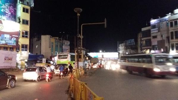
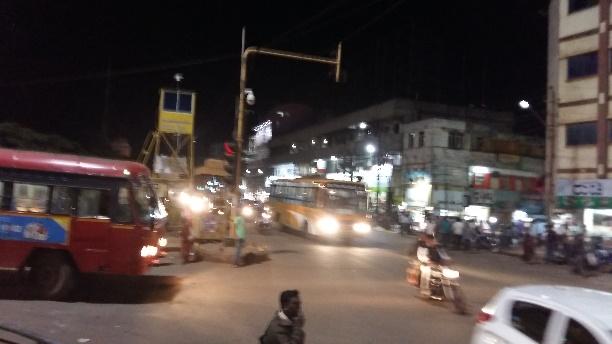
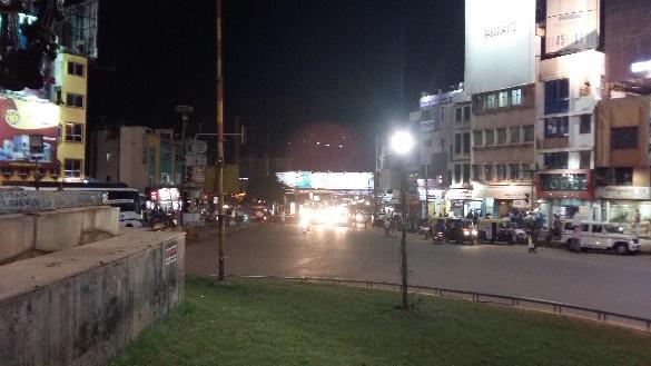
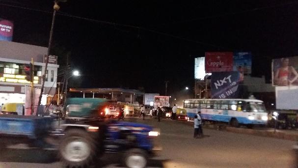
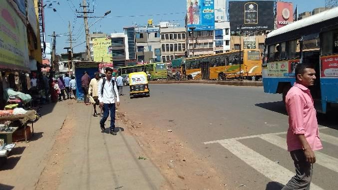
9 CURRENT ISSUES SEVERE TRAFFIC CONGESTION: 1. THROUGH TRAFFIC, LOCAL ACCESS TRAFFIC, PEDESTRIANS, CYCLISTS ALL VYING FOR SPACE 2. MORE THAN 200 CONFLICT POINTS. 3. LACK OF MODERN TRAFFIC TREATMENTS AND CONTROLS. 4. LACK OF BASIC PEDESTRIAN FACILITIES. 5. ON-STREET PARKING. LACK OF STORM WATER MANAGEMENT APPROACH FOR THE INTERSECTIONS. TRAFFIC DURING BAKRI EID AT RANI CHENNAMMA JUNCTION, HUBLI The City Development Plan for Hubli-Dharwad 2041 has identified Rani Chennamma Junction & Jubilee Circle as major accident-prone junctions. India loses Rs 60,000 crore due to traffic congestion: Study by Transport Corporation of India and IIM, Calcutta

10 EXISTING STATUS As per the CTTP Report, the Volume by Capacity Ratio (V/C Ratio) calculated on major stretches (even after public transport improvement and construction of ring road) indicates that certain stretches would still have unacceptable values of V/C ratios. Alternatives recommended to control private vehicular movement include measures such as construction of grade-separated structures in these stretches.

11 POPULATION DENSITY The effect of the authorities through CDP and CTTS is to contain the city growth within the municipal area. The future growth is likely to be mainly along the corridor between Hubli-Dharwad. The gross densities are expected to go up from the current 47 persons per hectare to 76 persons per hectare.
12 EVOLUTION OF THE SCHEMES A RIGOROUS PROCESS 1. FIELD WORK & FIELD DATA 2. STAKEHOLDER IDENTIFICATION 1. REVIEW OF REPORTS/MASTER-PLANNING STUDIES/LAND-USE PLANS/REPORTS INCLUDING CTTP 3. TRAFFIC STUDIES & STATE-OF-THE-ART VISSIM SIMULATION 4. STAKEHOLDER LIASION CLIENT AND BRTS 5. SITE VISITS 6. EXISTING AND PROPOSED LAND-USE PLANS 7. HUBLI DHARWAD COMPREHENSIVE TRAFFIC & TRANSPORTATION PLAN PREPARED BY DULT 8. HUBLI DHARWAD CITY DEVELOPMENT PLAN FOR 2041 PREPARED BY HDMC 9. BYPASSES 10.CONCEPT DRAWINGS 11.SOCIO-ECONOMIC ASPECTS 12.ENVIRONMENTAL SCREENING 13.R&R SCREENING 14.PRELIMINARY COST ESTIMATES
13 EVOLUTION OF THE SCHEMES OUR KEY STAKEHOLDER: NH PWD KARNATAKA 1. Proposed Smart City Developments Approved Smart City Plan for Hubli- Dharwad 2. DULT (Directorate of Urban Land Transport) 3. Hubli Dharwad Urban Development Authority (HDUDA) 4. Hubli Dharwad Unified Transport Authority (HDUTA) Comprehensive Traffic and Transport Plan (CTTP) for Hubli - Dharwad Consolidated Proposed Landuse Plan Zonal Regulations 5. Hubli Dharwad Municipal Corporation Revised City Development Plan for Hubli Dharwad, Infrastructure Development Department, KSIIDC-IL&FS Project Development Company (KIPDC) Final pre-feasibility report for development of multi-level car parking facilities on PPP format in cities of Karnataka 7. HDBRTS Implementation and Project Mgt of BRTS 8. REVENUE DEPT RoW 9. UTILITIES Utility related information

14 KEY STAKEHOLDERS AND REPORTS
15 SPECTRUM S DESIGN APPROACH SAFE INTERSECTIONS THAT ARE FUNCTIONALLY EFFICIENT, PEDESTRIAN-FRIENDLY & FLEXIBLE
16 FLYOVERS OR UNDERPASSES? At all the nominated intersections stipulated in the original TOR, Vehicular subways were investigated for the principal major traffic directions identified from the traffic analyses. Following were some of the adverse impacts and reasons that rendered these unfeasible: Constraints on efficient geometrical arrangement for safe and efficient traffic operations now and into the future; Urban space constraints for required carriageway widths, merging and demerging lanes; Existing urban buildings in close vicinity and the impact on their foundations; Subways investigated for Jubilee Circle (5-legged) and Rani Chennamma Junction (7-legged) do not address the traffic problems and safety/functionality requirements warranted for such dangerous intersections. Intersection drainage issues; Sight distance and safety issues; BRTS proposals At-grade intersections always have a potential for accidents due to conflicting crossing and turning vehicular movements, regardless of layout, signing and signalization. By separating the levels of intersecting roadways, both accidents and delays are reduced. Considering the above, flyovers as an option was investigated.


17 SAFETY ASPECTS - CONFLICT POINTS A conflict point is the point at which a road user crossing, merging with, or diverging from a road or driveway conflicts with another road user using the same road or driveway. It is any point where the paths of two through or turning vehicles diverge, merge, or cross.

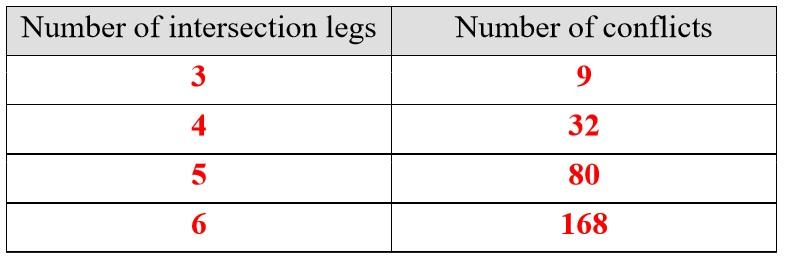
18 CONFLICT POINTS

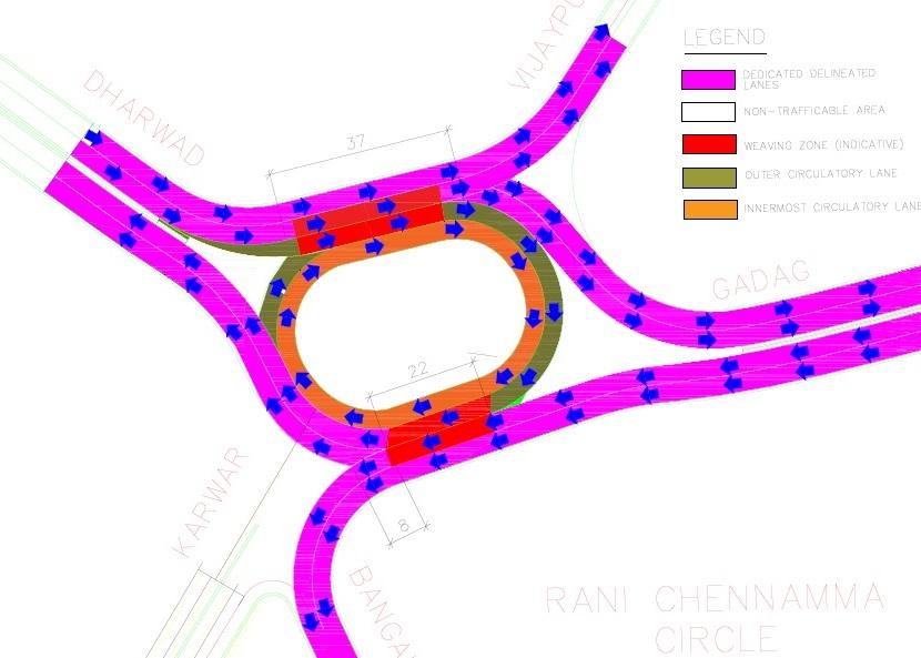
19 RANI CHENNAMMA CIRCLE
20 RANI CHENNAMMA CIRCLE TRAFFIC DISTRIBUTION E Towards Dharwad F Neeligin Road G Towards Bijapur Towards Gadag B Market D Karwar C Towards Bangalore/ Bankapur
21 TRAFFIC FORECAST - HUBBALLI S. No Intersection Name Intersection Type Volume in 2027 Volume in 2037 Traffic Manage Measures 1 Rani Chennamma Circle 7 Legged 17460* 24630* Elevated Rotary Interchange Proposed and Major directions are lifted up 2 Kamaripeth 4 Legged Elevated 4 lane 2 way flyover is proposed 3 New English School 5 Legged Elevated 4 lane 2 way flyover is proposed 4 Bankapur Chowk 4 Legged Elevated 4 lane 2 way flyover is proposed


22 RANI CHENNAMMA CIRCLE - OPTIONS INVESTIGATED OPTION 1 OPTION 2 OPTION 3


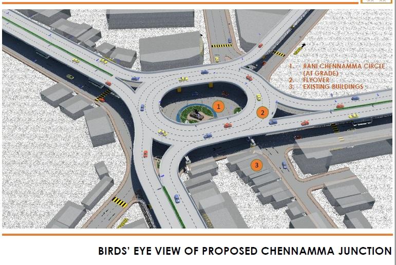
23 3D VIEW PROPOSED TREATMENTS GRADE SEPARATION OF THROUGH TRAFFIC & LOCAL ACCESS TRAFFIC ELEVATED ROTARY INTERCHANGE FOR THROUGH AND TURNING TRAFFIC & AT-GRADE TREATMENTS FOR LOCAL ACCESS TRAFFIC PLAN VIEW OF ELEVATED ROTARY


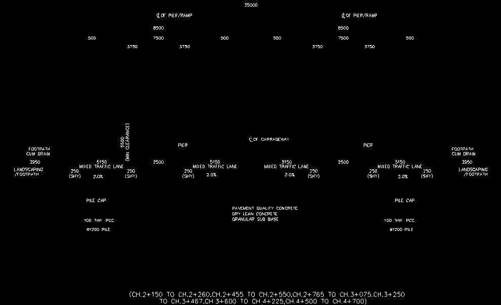
24 CROSS SECTION AT BRTS BUS STOP OPP OLD HUBLI BUS STAND

25 ARCHITECTURAL & URBAN INTERVENTIONS

26 ARCHITECTURAL & URBAN INTERVENTIONS

27 URBAN ELEMENTS

28 ARCHITECTURAL & URBAN INTERVENTIONS

29 ARCHITECTURAL & URBAN INTERVENTIONS

30 MODERN URBAN ELEMENTS

31 MODERN URBAN ELEMENTS

32 URBAN RANI CHENNAMMA JUNCTION
33
34 MODELLING & SIMULATION IN PTV VISSIM Spectrum supplied the CAD files of the existing terrain, aerial images, CAD files of the proposed concept along with traffic data to GMD. VISSIM 5.4/ VISSIM 9 was used for the modelling. Modelling requirements were quite complex given the geometry of the interchange. The existing situation was modelled by collecting data on aspects such as turn movements and queue lengths, as well as by taking aerial photographs. A base model was then created using this information. Base model was then validated for present conditions. On the Base model, the proposed option was modelled using the CAD files as background. Proposed model was then refined at junctions/crossings/turns to remove conflicts as well as for smooth movements. Fixed time signals were used to model the signals at junctions. Once the model stabilised, multiple iterations were done to extract the results. The model studies confirmed the need for signal optimisation at-grade due to the long queue lengths at the junction legs.

35 QUEUE LENGTHS

36 RANI CHANNAMMA CIRCLE - SIGNAL TIME 40 Sec 15 Sec 20 Sec 15 Sec 55 Sec 65 Sec E1 A1
 TO AND FROM OLD DSP JUNCTION PAST BRTS")
37 JUBILEE CIRCLE TRAFFIC DISTRIBUTION ELEVATED FLYOVER (2 WAY) TO AND FROM OLD DSP JUNCTION PAST BRTS BUS-STOP
38 TRAFFIC FORECAST JUBILEE CIRCLE, DHARWAD Intersection Name Elevated Traffic PCU** Balance Traffic PCU* Elevated Traffic PCU Balance Traffic PCU Elevated Traffic PCU Balance Traffic PCU Jubilee Circle * above balance traffic is from all arms, **considered elevated through traffic b/w Panjim Hubli

39 JUBILEE CIRCLE FLYOVER FOR THROUGH TRAFFIC & AT-GRADE TREATMENTS - FOR LOCAL ACCESS TRAFFIC BRTS BUS STOP AT-GRADE TRAFFIC TREATMENTS TO CHANNELISE TRAFFIC AND REDUCE CONFLICT POINTS PROVISION FOR PEDESTRIAN CROSSINGS, REFUGE ISLANDS AND MEDIANS


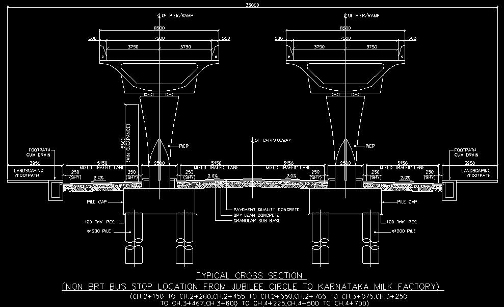
40 CROSS SECTIONS - JUBILEE CIRCLE
41 BENEFITS OF PTV VISSIM VISSIM allowed us to simulate and visualize exact traffic patterns and different scenarios. Simulation in VISSM helped us with observing vehicular interactions and actual conflict points and design remedial measures to reduce conflicts. The 3D visualizations made complex traffic situations appealing and understandable to all. 3D visualizations of the concepts helped present convincing and comprehensible measures to the decision-makers/stakeholders. Present conditions are validated using the VISSIM model and signal optimization was carried out. It enabled us to analyze trip lengths and the likelihood of traffic using the proposed flyovers/interchange and vice-versa. Cost savings are achieved through the reduction in queue lengths, delays as predicted by the VISSIM simulation. This had a positive impact on travel times, emissions and traffic flow.
42 Rani Chennamma Junction - Safe, Inclusive and Welcoming intersection for All A rotary is an intersection where traffic flows in a circular pattern. Outer dedicated, delineated arms are provided for through traffic that need not enter the circulatory motion. Rotaries allow for the movement of more traffic in less time than a normal intersection because they do not have stop signs or traffic lights. Rotaries can also improve the safety of an intersection as there are no left turns in front of oncoming vehicles & also act as a traffic calming measure since traffic moves slower through the intersection. Studies have shown modern rotaries to eliminate head on and high speed collisions resulting in a 90% reduction in fatalities, 80% reduction in injuries and a 40% reduction in overall collisions. Requires minimal to no land acquisition at Rani Chennamma Junction. Flexibility is built into the interchange design to accommodate possible future changes, particularly when changes to land use are likely to substantially alter traffic patterns. The proposed solutions separate the major crossing movements and enable maximum traffic volumes to operate uninterrupted. By minimising conflicts, the proposed solutions offer safer and welcoming intersections that are functionally efficient & aesthetically pleasing. For Rani Chennamma Junction flexibility for future expansion without reconstruction is provided. Gives a visually pleasing view of the historically significant and heritage listed Rani Chennamma statue when travelling over the rotary thereby enhancing the community character and pride of the locals.
43 BENEFITS OF THE PROPOSED TREATMENTS/SOLUTIONS EFFICIENT OPERATION: Accommodates the warranted turning & through movements identified through the traffic analysis; SAFE: Substantially reduces the number of conflict points between heavy through traffic and local access traffic. Improves the safety of the at-grade intersection and interchange by grade separating heavy vehicles from pedestrians and local access traffic. Makes the at-grade intersections more welcoming and pedestrian-friendly. Traffic calming measures are incorporated in the design concept. STAKEHOLDER REQUIREMENTS: Considers Smart City & relevant authority requirements for pedestrian safety/movements at the at-grade level by separating heavy through traffic and a proportion of local access traffic thereby making the at-grade intersection safer. AT-GRADE: Helps better planning and design of the at-grade traffic treatments which would cater mainly to local access traffic, pedestrians, cyclists, buses travelling to and from the nearby bus stands and BRTS. INCLUSIVE: At the at-grade level, safely accommodates and makes allowances for multiple modes (i.e. pedestrians, cyclists, BRTS and low to medium density local access vehicular traffic) thereby making it safer and more functional and in line with Smart City requirements. FUNCTIONAL: Improves overall traffic operations by appropriate restriction of access & enforcing consistent traffic behavior to allow the local road system and the heavy through traffic to operate effectively and efficiently. Treatments proposed are aesthetically pleasing in form & function. CAPACITY: Reduces/eliminates capacity and congestion issues associated with vehicular parking at and in the vicinity of the at-grade intersections. For Rani Chennamma Junciton, flexibility is provided for future expansion without reconstruction.

44 HUBBALLI - SIMULATION IN PTV VISSIM

45 DHARWAD - SIMULATION IN PTV VISSIM
46 THANK YOU
Grade Separated Intersection
 Grade Separated Intersection Lecture Notes in Transportation Systems Engineering Prof. Tom V. Mathew Contents 1 Overview 1 2 Classification of Intersection 2 2.1 Grade Separated Intersection...........................
A127/A130 Fairglen Interchange Improvement Schemes. Information Leaflet February 2017
 A127/A130 Fairglen Interchange Improvement Schemes Information Leaflet February 2017 1 2 Foreword By Councillor Kevin Bentley Essex is continuing to grow as a vibrant economic hub and as a fantastic place
Urban Street Design and Development
 Urban Street Design and Development Ashok Bhattacharjee, Advisor, Clean Air and Sustainable Mobility, Centre for Science and Environment CSE Workshop on Safe Access and Parking - Lytton Hotel, Kolkata
AMATS Complete Streets Policy
 AMATS Complete Streets Policy Table of Contents: Section 1. Definition of Complete Streets Section 2. Principles of Complete Streets Section 3. Complete Streets Policy Section 4. Consistency Section 5.
Decongestion Strategies for Delhi Roads
 PWD, Delhi 1 Presented By: Sh.Manoj Kumar(CPM); Sh.Ravi Kant (S.E); Sh.A.K.Agrawal (S.E) Public Works Department - GNCTD Agendas Main Challenges in Delhi Population, Land, Multiplicity of Authorities,
Traffic Signal Design
 Traffic Signal Design Instructor: S. M. Mahdi Amiripour m.amiripour@gmail.com 2 Introduction Intersection is an area shared by two or more roads Designated for the vehicles to turn to different directions
Freeway System Considerations
 Session 11 Jack Broz, PE, HR Green May 5-7, 2010 Freeway System Considerations Mainline Transit: Shoulder Operations, BRT, Stations HOV, HOT, UPA Interchanges Exit Ramps Entrance Ramps Bridges Local Crossings
Intersection Improvement: Sturgeon Road, Silver Avenue and Murray Park Road Roundabout. Welcome. Public Information Session
 Intersection Improvement: 1 Welcome WHY IS AN INTERSECTION IMPROVEMENT NEEDED? 2 Traffic volumes for Sturgeon Road, Silver Avenue and Murray Park Road exceed the capacity of the existing 4-way stop controlled
Highway 111 Corridor Study
 Highway 111 Corridor Study June, 2009 LINCOLN CO. HWY 111 CORRIDOR STUDY Draft Study Tea, South Dakota Prepared for City of Tea Sioux Falls Metropolitan Planning Organization Prepared by HDR Engineering,
METHODOLOGY. Signalized Intersection Average Control Delay (sec/veh)
") Chapter 5 Traffic Analysis 5.1 SUMMARY US /West 6 th Street assumes a unique role in the Lawrence Douglas County transportation system. This principal arterial street currently conveys commuter traffic
Chapter 5 Traffic Analysis 5.1 SUMMARY US /West 6 th Street assumes a unique role in the Lawrence Douglas County transportation system. This principal arterial street currently conveys commuter traffic
HIGHBURY AVENUE/HAMILTON ROAD INTERSECTION IMPROVEMENTS PUBLIC INFORMATION CENTRE 1 MAY 14, 2015
 HIGHBURY AVENUE/HAMILTON ROAD INTERSECTION IMPROVEMENTS Municipal Class Environmental Assessment PUBLIC INFORMATION CENTRE 1 MAY 14, 2015 ACCESSIBILITY Under the Accessibility Standards 2015 for Customer
Chapter 33. Grade Separated Intersection Overview Classification of Intersection Grade Separated Intersection
 Chapter 33 Grade Separated Intersection 33.1 Overview An intersection is the area shared by the joining or crossing of two or more roads. Since the main function of an intersection is to enable the road
INNOVATIVE INTERSECTION SOLUTIONS. Jay Bockisch, PE, PTOE Senior Associate
 INNOVATIVE INTERSECTION SOLUTIONS Jay Bockisch, PE, PTOE Senior Associate INNOVATIVE INTERSECTION SOLUTIONS Innovative intersection overview Case studies Continuous flow intersection Modern roundabouts
Tonight is for you. Learn everything you can. Share all your ideas.
 Strathcona Neighbourhood Renewal Draft Concept Design Tonight is for you. Learn everything you can. Share all your ideas. What is Neighbourhood Renewal? Creating a design with you for your neighbourhood.
INNOVATIVE INTERSECTION DESIGN
 INNOVATIVE INTERSECTION DESIGN J. Eddie Valtier, P.E. ELP TP&D Director Introduction Why Do We Need To Start Looking For Innovative Intersection Designs? Congestion is worsening and traffic volumes and
Tonight is an opportunity to learn about the Study and ask questions of the Study Team members.
 Exhibit 1 Welcome Second Open House Tonight is an opportunity to learn about the Study and ask questions of the Study Team members. A first Public Open House was held on September 18th, 2013 which presented
TRANSPORTATION NEEDS ASSESSMENT
 TRANSPORTATION NEEDS ASSESSMENT A travel demand analysis was carried out to determine the operational issues and the potential benefit that adding traffic capacity would have on the road network. All the
City of Homewood Transportation Plan
 City of Homewood Transportation Plan Prepared for: City of Homewood, Alabama Prepared by: Skipper Consulting, Inc. May 2007 TABLE OF CONTENTS INTRODUCTION... 1 BACKGROUND INFORMATION... 1 EXISTING TRANSPORTATION
Comments EXECUTIVE SUMMARY
 Comments 1. Under any Alternatives, MCDOT should provide better at-grade pedestrian crossing of Georgia Avenue and Forest Glen Road, including improved crosswalks with wider medians and adequate signal
Highway 49, Highway 351 and Highway 91 Improvements Feasibility Study Craighead County
 Highway 49, Highway 351 and Highway 91 Improvements Feasibility Study Craighead County Executive Summary March 2015 Highway 49, Highway 351 and Highway 91 Improvements Feasibility Study Craighead County
ROUTES 55 / 42 / 676 BUS RAPID TRANSIT LOCALLY PREFERRED ALTERNATIVE
 ROUTES 55 / 42 / 676 BUS RAPID TRANSIT LOCALLY PREFERRED ALTERNATIVE April, 2012 1 INTRODUCTION The need for transit service improvements in the Routes 42/55/676 corridor was identified during the Southern
Intersection Safety 6/7/2015 INTERSECTIONS. Five basic elements should be considered in intersection design. Intersection Safety (continued)
") Intersection Safety S. M. SOHEL MAHMUD Assistant Professor Accident Research Institute (ARI), Bangladesh University of Engineering and Technology (BUET) Dhaka-1000, Bangladesh 1 Outline of the Presentation
Intersection Safety S. M. SOHEL MAHMUD Assistant Professor Accident Research Institute (ARI), Bangladesh University of Engineering and Technology (BUET) Dhaka-1000, Bangladesh 1 Outline of the Presentation
Recommended Roadway Plan Section 2 - Land Development and Roadway Access
 Recommended Roadway Plan Section 2 - Land Development and Roadway Access SECTION 2 Land Development and Roadway Access 2.1 Land Use and Access Management The Federal Highway Administration (FHWA) defines
APPENDIX 2 LAKESHORE ROAD TRANSPORTATION REVIEW STUDY EXECUTIVE SUMMARY
 APPENDIX 2 LAKESHORE ROAD TRANSPORTATION REVIEW STUDY EXECUTIVE SUMMARY Appendix 2 City of Mississauga Lakeshore Road FINAL REPORT Transportation Review Study December 2010 EXECUTIVE SUMMARY Study Purpose
MILTON ROAD LLF PROJECT UPDATE
 Greater Cambridge City Deal MILTON ROAD LLF PROJECT UPDATE 9 th May 2017 Project objectives Comprehensive priority for buses in both directions wherever practicable; Additional capacity for sustainable
Frequently Asked Questions
 Frequently Asked Questions Business US 190 in Copperas Cove From Avenue D to Constitution Drive What is access management? A. Access Management is a growing effort by government agencies to improve how
Access Location, Spacing, Turn Lanes, and Medians
 Design Manual Chapter 5 - Roadway Design 5L - Access Management 5L-3 Access Location, Spacing, Turn Lanes, and Medians This section addresses access location, spacing, turn lane and median needs, including
Transportation Master Plan Advisory Task Force
 Transportation Master Plan Advisory Task Force Network Alternatives & Phasing Strategy February 2016 BACKGROUND Table of Contents BACKGROUND Purpose & Introduction 2 Linking the TMP to Key Council Approved
South King County High-Capacity Transit Corridor Study
 HIGH-CAPACITY TRANSIT CORRIDOR STUDY South King County Corridor South King County High-Capacity Transit Corridor Study Corridor Report August 2014 South King County High Capacity Transit Corridor Report
8 PROPOSED ROUNDABOUT DUFFERIN STREET AND KING VAUGHAN ROAD INTERSECTION CITY OF VAUGHAN
 8 PROPOSED ROUNDABOUT DUFFERIN STREET AND KING VAUGHAN ROAD INTERSECTION CITY OF VAUGHAN The Transportation Services Committee recommends the adoption of the recommendation contained in the following report
Roundabouts The Virginia Experience
 Roundabouts The Virginia Experience Purpose of Briefing Misconceptions Background on Roundabouts How they pertain to Virginia Definition & Operational Characteristics Roundabouts Vs. Traffic signals Considerations
Introduction Methodology Study area and data collection Results and recommendation Conclusion References
 Introduction Methodology Study area and data collection Results and recommendation Conclusion References It is formal procedure for assessing accident potential and safety performance in the provision
WELCOME TO OPEN HOUSE # 1 June 14, 2017
 Langstaff Road Weston Road to Highway 7 Class Environmental Assessment Study WELCOME TO OPEN HOUSE # 1 June 14, 2017 Please sign in and join our mailing list Purpose of Open House #1 & Study Area York
Route 29 Corridor Assessment Update. Development of Possible Solutions
 Route 29 Corridor Assessment Update Development of Possible Solutions Public Workshop #3 October 27, 2016 Purpose of Developing Possible Solutions Recap of where we ve been and timeline for moving forward
4. Guided Bus Explained
 4. Guided Bus Explained Contents 1 INTRODUCTION... 2 Structure of this report... 2 2 KERB GUIDED BUS... 3 Overview... 3 Kerb guidance... 3 Figures Figure 2.1 Figure 2.2 Figure 2.3 Figure 2.4 Figure 2.5
Complete Streets Successes, Opportunities, and Challenges
 Complete Streets Successes, Opportunities, and Challenges Juliet Walker, Transportation Planner, City of Portsmouth Rob Houseman, Director of Planning and Development, Town of Wolfeboro Chris Parker, Director
Southwest Bus Rapid Transit (SW BRT) Functional Planning Study - Executive Summary January 19 LPT ATTACHMENT 2.
 Functional Planning Study - Executive Summary January 19 LPT ATTACHMENT 2.") Southwest Bus Rapid Transit (SW BRT) Functional Planning Study - Executive Summary 2011 January 19 1 of 19 Introduction This executive summary presents the results of the Southwest Bus Rapid Transit (SW
Southwest Bus Rapid Transit (SW BRT) Functional Planning Study - Executive Summary 2011 January 19 1 of 19 Introduction This executive summary presents the results of the Southwest Bus Rapid Transit (SW
M-58 HIGHWAY ACCESS MANAGEMENT STUDY Mullen Road to Bel-Ray Boulevard. Prepared for CITY OF BELTON. May 2016
 M-58 HIGHWAY ACCESS MANAGEMENT STUDY Prepared for CITY OF BELTON By May 2016 Introduction Missouri State Highway 58 (M-58 Highway) is a major commercial corridor in the City of Belton. As development has
Pattullo Bridge Replacement Project Community Connections Phase 2 Consultation. Appendix 3: Open House Display Boards
 Replacement Project Community Connections Phase 2 Consultation Appendix 3: Open House Display Boards November 2016 Welcome! Welcome to the Replacement Project Public Open House We Want to Hear from You
Design of Stanley Park S-Curve
 ADMINISTRATIVE REPORT Date: May 4, 2001 TO: FROM: Author/Local: F. Klotzbach/7118 RTS NO. 01644 CC File No. Standing Committee on Transportation and Traffic General Manager of Engineering Services, in
TRAFFIC STUDY REPORT
 Of THE PROPOSED SURAT DIAMOND BOURSE SURAT, GUJARAT Prepared for M/s SDB Diamond Bourse February 2018 Traffic Study of the Proposed Surat Diamond Bourse, Surat, Gujarat February 2018 Client : M/s SDB Diamond
Chapter 7 Intersection Design
 hapter 7 Dr. Yahya Sarraj Faculty of Engineering The Islamic University of Gaza An intersection is an area, shared by two or more roads, whose main function is to provide for the change of route directions.
PennDOT ICE Policy An Introduction
 PennDOT ICE Policy An Introduction January 2018 What is Intersection Control Evaluation (ICE)? Purpose: To consistently consider and screen among many proven combinations of geometry and traffic control
Preliminary Transportation Analysis
 Preliminary Transportation Analysis Goals of a Robust, Multimodal Transportation Network Safe Accessible/Connected Efficient Comfortable Context-Sensitive Motor Vehicle: Continue to analyze the data to
Appendix A: Crosswalk Policy
 Appendix A: Crosswalk Policy Appendix A: Crosswalk Policy Introduction This citywide Crosswalk Policy is aimed at improving pedestrian safety and enhancing pedestrian mobility by providing a framework
Experience from India Future Perspectives
 Experience from India Future Perspectives The 2 nd Asia BRTS Conference September 29 and 30, 2014 Amdavad Prof. Shivanand Swamy Executive Director Centre of Excellence in Urban Transport, CEPT University
BURGAS INTEGRATED PUBLIC TRANSPORT PROJECT. Information day, 5 th July 2011, Burgas
 BURGAS INTEGRATED PUBLIC TRANSPORT PROJECT Information day, 5 th July 2011, Burgas BRT TECHNICAL DESIGN TENDER Preliminary tender specifications and requirements Overview 1 Burgas BRT concept 2 Main outputs
City of Wayzata Comprehensive Plan 2030 Transportation Chapter: Appendix A
 A1. Functional Classification Table A-1 illustrates the Metropolitan Council s detailed criteria established for the functional classification of roadways within the Twin Cities Metropolitan Area. Table
Richmond-Adelaide Cycle Tracks
 Public Drop-In Event Richmond-Adelaide Cycle Tracks June 25, 2018 12:00 p.m. 3:00 p.m. 4:30 p.m. 7:30 p.m. Metro Hall, Rotunda 55 John Street 1 Purpose of Event In Scope Communicate an update about the
Regional Transportation Needs Within Southeastern Wisconsin
 Regional Transportation Needs Within Southeastern Wisconsin #118274 May 24, 2006 1 Introduction The Southeastern Wisconsin Regional Planning Commission (SEWRPC) is the official areawide planning agency
Modern Roundabouts: a guide for application
 Modern Roundabouts: a guide for application Kentucky Community Transportation Innovation Academy 2005 The contents of this booklet reflect the views of the authors who are responsible for the facts and
ENGINEERING DESIGN STANDARDS TO ENSURE ROAD SAFETY: EXPERIENCES FROM INDIA
 ENGINEERING DESIGN STANDARDS TO ENSURE ROAD SAFETY: EXPERIENCES FROM INDIA Atul Kumar 1 ABSTRACT The primary goal of designing roads with adequate standards is to achieve a safer transport facility for
The Cabinet Member for Highways & Streetscene. Aurang Zeb - Head of Highways & Transport
 LONDON BOROUGH OF RICHMOND UPON THAMES Cabinet Member Decision DATE: January 2012 REPORT OF: LEAD OFFICER: SUBJECT: WARDS: The Cabinet Member for Highways & Streetscene Aurang Zeb - Head of Highways &
INDEX. Geometric Design Guide for Canadian Roads INDEX
 Acceleration lane, see Lanes, Acceleration Access, 8.1 Access Management and Functional Classification 8.2 Access Management by Design Classification 8.3 Access Configuration 8.4 Building Set-Back Guidelines
Broad Street Bicycle Boulevard Design Guidelines
 Broad Street Bicycle Boulevard Design Guidelines Building from the strategies introduced in the 2013 Bicycle Transportation Plan and community input received thus far, City Transportation Staff have identified
FEASIBLE SOLUTIONS FOR REDUCING TRAFFIC FROM MEERAMAKKAM MOSQUE JUNCTION TO THOPAWANA TEMPLE AREA IN KANDY
 FEASIBLE SOLUTIONS FOR REDUCING TRAFFIC FROM MEERAMAKKAM MOSQUE JUNCTION TO THOPAWANA TEMPLE AREA IN KANDY A.M.Z. Zimar 1*, P. Sanjeevan 2 1 South Eastern University of Srilanka, Srilanka 2 Central Engineering
NRA New Divided Road Types: Type 2 and Type 3 Dual - Carriageways
 NRA New Divided Road Types: Type 2 and Type 3 Dual - Carriageways DN-GEO-03059 December 2007 DN Design Technical TRANSPORT INFRASTRUCTURE IRELAND (TII) PUBLICATIONS About TII Transport Infrastructure Ireland
Justification and Feasibility of Roundabout
 Justification and Feasibility of Roundabout Shruti B. Khara M. E. Sem IV Transportation Engineering L. D. College of Engineering Ahmedabad e-mail shruti21063@gmail.com Prof. Ashutosh K. Patel Lecturer
Improvement of pedestrian safety and traffic flow regulation at the railway junction, Kandy
 J.Natn.Sci.Foundation Sri Lanka 2013 41 (3): 259-270 DOI: http://dx.doi.org/10.4038/jnsfsr.v41i3.6060 RESEARCH ARTICLE Improvement of pedestrian safety and traffic flow regulation at the railway junction,
Omaha s Complete Streets Policy
 Omaha s Complete Streets Policy (Adopted August 2015) VISION To create great places and enhance our quality of life, the City of Omaha will provide safe, accessible streets for all users. Complete Streets
Albany Shaker Road Corridor Study Public Meeting # 2
 Albany Shaker Road Corridor Study Public Meeting # 2 Scope / Meeting Purpose This project is a CDTC Linkage Study. The Linkage Program is designed to implement the adopted planning and investment principles
Route 29 Solutions Projects
 Route 29 Solutions Route 29 Solutions Projects www.route29solutions.org October 10, 2014 Route 29 Widening to Six Lanes Albemarle County This project will widen a 1.8-mile segment of Route 29 from four
TECHNICAL MEMORANDUM VDOT Central Region On Call Task Order
 Kittelson & Associates, Inc. T R A N S P O R T A T I O N E N G I N E E R I N G / P L A N N I N G 1850 Centennial Park Drive, Suite 130, 20191 P 703-885-8970 F 703-885-8971 TECHNICAL MEMORANDUM VDOT Central
CITY OF COCOA BEACH 2025 COMPREHENSIVE PLAN. Section VIII Mobility Element Goals, Objectives, and Policies
 CITY OF COCOA BEACH 2025 COMPREHENSIVE PLAN Section VIII Mobility Element Goals, Objectives, and Policies Adopted August 6, 2015 by Ordinance No. 1591 VIII MOBILITY ELEMENT Table of Contents Page Number
Public Information Centre
 WELCOME Public Information Centre Father Tobin Road Lougheed Middle School - Library Wednesday November 7, 2012 7:00 p.m.to 9:00 p.m. Please sign in Neighbourhood Traffic Calming Guide Background The City
List of Display Boards
 List of Display Boards Welcome Introduction Municipal Class Environmental Assessment (EA) Process Need and Justification for an Interchange Alternatives for Evaluation Vertical and Horizontal Alignments
Dr. Naveed Anwar Executive Director, AIT Consulting Affiliated Faculty, Structural Engineering Director, ACECOMS
 Dr. Naveed Anwar Executive Director, AIT Consulting Affiliated Faculty, Structural Engineering Director, ACECOMS Overview Highway Functions and Classifications Highway Design Components Design Control
Clackamas County Comprehensive Plan
 ROADWAYS The County s road system permits the movement of goods and people between communities and regions, using any of a variety of modes of travel. Roads provide access to virtually all property. They
TRANSPORTATION ANALYSIS REPORT US Route 6 Huron, Erie County, Ohio
 TRANSPORTATION ANALYSIS REPORT US Route 6 Huron, Erie County, Ohio December 12, 2012 Prepared for: The City of Huron 417 Main Huron, OH 44839 Providing Practical Experience Technical Excellence and Client
Bay to Bay Boulevard Complete Streets Project
 Bay to Bay Boulevard Complete Streets Project Dale Mabry Highway to Bayshore Boulevard February 08, 2018 Photo Source: Tampa Bay Times Alessandra Da Pra Meeting Format Introduction Resurfacing Information
MOBILITY CHALLENGES IN HILL CITIES
 MOBILITY CHALLENGES IN HILL CITIES Lalmuansanga Ralte, MCS Pvt Secretary to Minister & Under Secretary Urban Development & Poverty Alleviation Department Govt. of Mizoram DEMOGRAPHIC OVERVIEW INDIA MIZORAM
Appendix A-2: Screen 1 Alternatives Report
 Appendix A-2: Screen 1 Alternatives Report SCREEN 1 ALTERNATIVES REPORT Western & Ashland Corridors Bus Rapid Transit (BRT) Project Prepared for Chicago Transit Authority 567 West Lake Street Chicago,
Access Management Regulations and Standards
 Access Management Regulations and Standards January 2014 Efficient highway operation Reasonable property access Concept of Access Management The way to manage access to land development while preserving
Roadways. Roadways III.
 Introduction 97 Roadway Design Principles 98 Safe Speeds 99 Optimizing of Street Space 00 Minimum Lane Widths in the City of Boston 02 Design Features that Reduce Operating Speeds 05 Travel Lanes Transit
FONTAINE AVENUE STUDY Final Report
 FONTAINE AVENUE STUDY Final Report March 28, 2005 FONTAINE AVENUE STUDY City of Charlottesville March 28, 2005 Renaissance Planning Group Kenneth Schwartz, FAIA, AICP Director of Design Leigh Wilkerson,
2015 Florida Main Street Annual Conference. Complete Streets Equal Stronger Main Streets
 WHAT ARE COMPLETE STREETS? CASE STUDIES COMPLETING YOUR MAIN STREET 2015 Florida Main Street Annual Conference St. Petersburg, Florida August 19, 2015 WHAT ARE COMPLETE STREETS? CASE STUDIES COMPLETING
WELCOME. Stakeholder Involvement Group Meeting #2 Round Lake Public Works October 24, 2018
 WELCOME Stakeholder Involvement Group Meeting #2 Round Lake Public Works October 24, 2018 MEETING AGENDA 1. Welcome and Introductions 2. Study Progress Update 3. Problem Statement 4. Technical Analysis
Downtown BRT Corridor Alternatives Review: 1 st, 2 nd, 3 rd and 4 th Avenue. Bus Rapid and Conventional Transit Planning and Design Services
 Downtown BRT Corridor Alternatives Review: 1 st, 2 nd, 3 rd and 4 th Avenue Bus Rapid and Conventional Transit Planning and Design Services City of Saskatoon February 2018 Project Team HDR Corporation
5. RUNNINGWAY GUIDELINES
 5. RUNNINGWAY GUIDELINES These guidelines should be considered collectively when making runningway decisions. A runningway is the linear component of the transit system that forms the right-of-way reserved
Simulating Street-Running LRT Terminus Station Options in Dense Urban Environments Shaumik Pal, Rajat Parashar and Michael Meyer
 Simulating Street-Running LRT Terminus Station Options in Dense Urban Environments Shaumik Pal, Rajat Parashar and Michael Meyer Abstract The Exposition Corridor transit project is a light rail project
Analysis of Causal Factors of Accidents near Mahipalpur Junction on NH-8 in Delhi
 Analysis of Causal Factors of Accidents near Mahipalpur Junction on NH-8 in Delhi Nirpinder Jain 1, Bharat Bhushan Jindal 2 1, 2 (Research Scholar, IK Gujral Punjab Technical University, Kapurthala, Punjab,
AGENDA REPORT. Issue: Discussion of potential improvements on Barnwell Road at Niblick Drive
 AGENDA REPORT To: From: By: Honorable Mayor and City Council Members Warren Hutmacher, City Manager Tom Black, Public Works Director Date: March 23, 2016 Agenda: March 28, 2016 WORK SESSION AGENDA: Barnwell
Vision: Traditional hamlet with an attractive business/pedestrian friendly main street connected to adjacent walkable neighborhoods
 N D. Focus Area II Vision: Traditional hamlet with an attractive business/pedestrian friendly main street connected to adjacent walkable neighborhoods Transit Road Focus Area II is located in the Hamlet
TRAFFIC IMPACT STUDY CRITERIA
 Chapter 6 - TRAFFIC IMPACT STUDY CRITERIA 6.1 GENERAL PROVISIONS 6.1.1. Purpose: The purpose of this document is to outline a standard format for preparing a traffic impact study in the City of Steamboat
C.A.R.S. Project Design Report.
 C.A.R.S. Project Design Report. PRODUCED BY: Browne, A. Kennedy, M. Dolan, N. Selman, C. STUDENT NO: DATE DUE: COURSE: LECTURER: C09365788-C09686908-D11125480-C08868352 20-April-2012 Dt004/3 Civil Engineering
Caltrans Sloat Boulevard Pedestrian Safety Project Response to Community Questions, Comments & Concerns
 Caltrans Sloat Boulevard Pedestrian Safety Project Response to Community Questions, Comments & Concerns Revised: May 10, 2016 The California Department of Transportation (Caltrans) is planning various
TOWN OF PORTLAND, CONNECTICUT COMPLETE STREETS POLICY
 TOWN OF PORTLAND, CONNECTICUT COMPLETE STREETS POLICY I. VISION, GOALS & PRINCIPLES VISION To improve the streets of Portland making them safer and more accessible for all users including pedestrians,
TOWN OF CHAPEL HILL POLICY AND PROCEDURES FOR TRAFFIC CALMING MEASURES
 TOWN OF CHAPEL HILL POLICY AND PROCEDURES FOR TRAFFIC CALMING MEASURES (Adopted by the Town Council on June 30, 2004) (Revised December 6, 2010) (Revised February 8, 2016) POLICY AND PROCEDURES FOR TRAFFIC
Welcome to the Open House
 Leslie Street Between 19 th Avenue and Stouffville Road Addendum to Class Environmental Assessment Study Welcome to the Open House Please sign in at the front desk. March 28, 2017 Richmond Green Sports
THE FUTURE OF THE TxDOT ROADWAY DESIGN MANUAL
 THE FUTURE OF THE TXDOT ROADWAY DESIGN MANUAL Kenneth Mora, P.E. (Design Division) 10/10/2017 Table of contents 1 2 Reduction in FHWA design controlling criteria Innovative Intersection Guidance 3-7 8-42
Chapter V Transportation Concept Alternatives
 Chapter V Transportation Concept Alternatives Three (3) fundamentally different approaches to meeting vehicular travel needs in the corridor were considered. One approach is to leave the road as it is
Solana Beach Comprehensive Active Transportation Strategy (CATS)
") Solana Beach Comprehensive Active Transportation Strategy (CATS) 3.0 Goals & Policies The Solana Beach CATS goals and objectives outlined below were largely drawn from the Solana Beach Circulation Element
Solana Beach Comprehensive Active Transportation Strategy (CATS) 3.0 Goals & Policies The Solana Beach CATS goals and objectives outlined below were largely drawn from the Solana Beach Circulation Element
C C C
 C-012-001 Thank you for your support for the creation of new public space and nonmotorized access between downtown and the waterfront through the Overlook Walk, the East-West Connections, and the Promenade.
STATION #3 INITIAL ALTERNATIVES
 www.dot.il.gov www.eisenhowerexpressway.com STATIO #3 IHB RR Heavy Rail Transit (HRT) High capacity transit mode serving urban areas:» Steel wheeled, high performance electric powered rail vehicles» Right-of-way
Intersection Traffic Control Feasibility Study
 Intersection Traffic Control Feasibility Study CSAH 9 at CSAH 60 (185th Avenue) Prepared For: Dakota County Transportation Department Western Service Center 14955 Galaxie Avenue, 3rd Floor Apple Valley,
BELFAST RAPID TRANSIT. Ciarán de Búrca Director, Transport Projects Division Department for Regional Development
 BELFAST RAPID TRANSIT Ciarán de Búrca Director, Transport Projects Division Department for Regional Development Objectives of Belfast Rapid Transit To provide a modern, safe, efficient and high quality
1 st and 2 nd Street Couplet FAQ s
 1 st and 2 nd Street Couplet FAQ s Q. Will the proposed roundabout at Flume/2nd/1 st Streets affect access to businesses nearby?... 2 Q. What if the project isn t received well by the community after construction?...
Road Safety Assessments. Lt. Bob McCurdy Williamson County Sheriff s s Office Marion, IL.
 Road Safety Assessments Lt. Bob McCurdy Williamson County Sheriff s s Office Marion, IL. Why Are We Here? 2005 US Traffic Fatalities = 43,443 1429 4329 1361 1616 1534 3504 1729 3543 Illinois Annual Fatallities
Operational Comparison of Transit Signal Priority Strategies
 Operational Comparison of Transit Signal Priority Strategies Revision Submitted on: November, 0 Author: Adriana Rodriguez, E.I Assistant Engineer Parsons Brinckerhoff 0 South Orange Avenue, Suite 00 Orlando,
ROUNDABOUTS/TRAFFIC CIRCLES
 GENERAL 1. Description This standard identifies minimum requirements that shall be met for Roundabouts and Neighborhood Traffic Circles in the design and construction of elements for Arlington County Horizontal