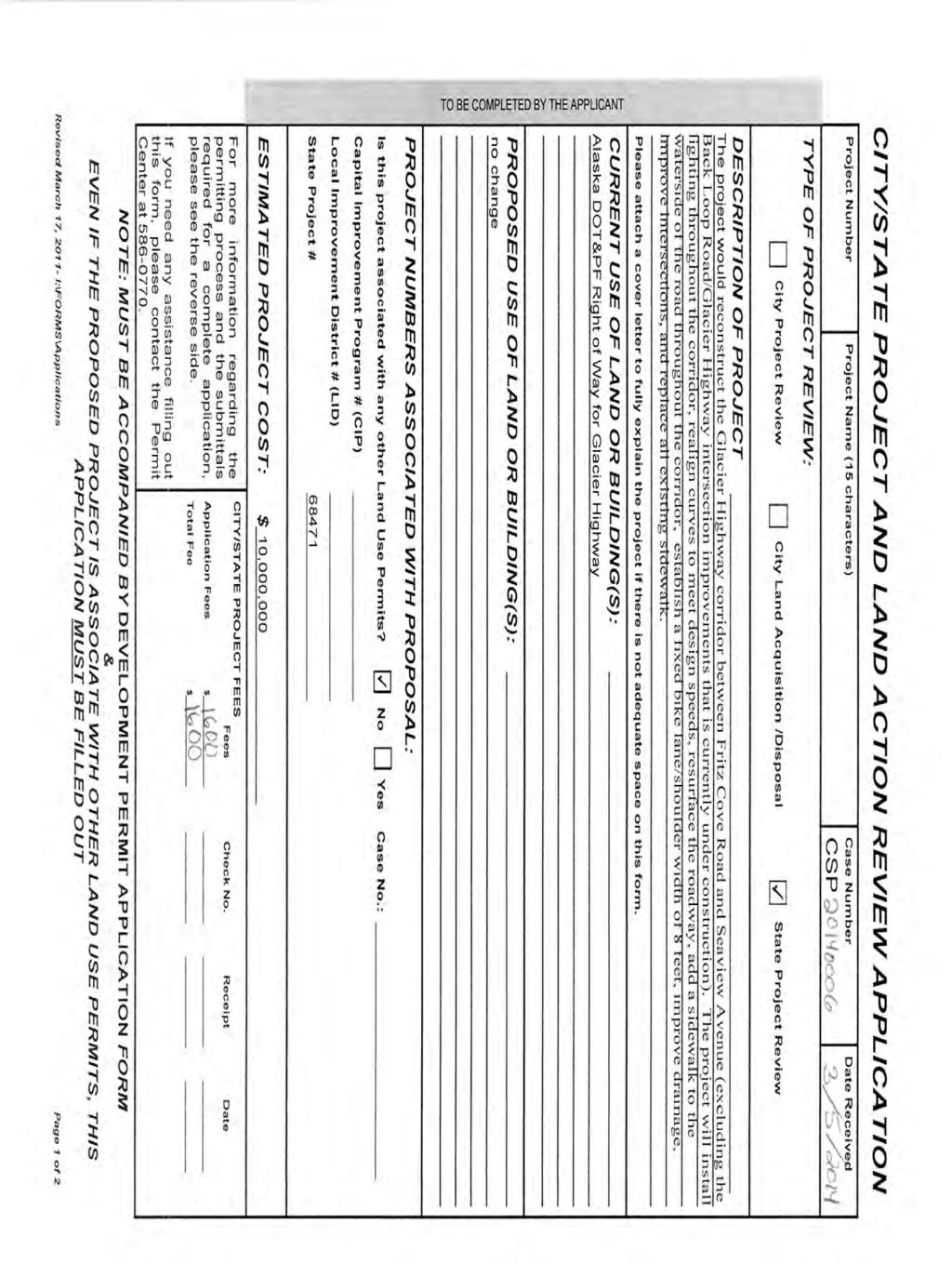
Alaska Department of Transportation and Public Facilities. Glacier Highway from Fritz Cove Road to Seaview Avenue. 1 mile long, feet wide
|
|
|
- Willis Hardy
- 6 years ago
- Views:
Transcription

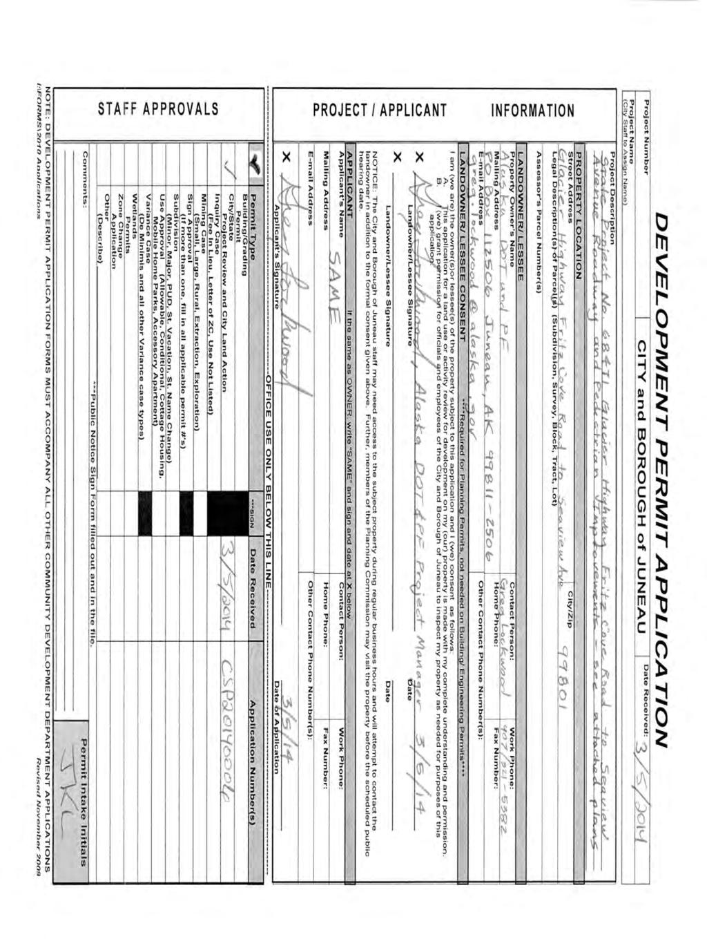
1 DATE: May 5, 2014 TO: FROM: Planning Commission Travis Goddard, Planning Manager Community Development Department FILE NO.: CSP PROPOSAL: Review of Alaska DOT&PF project 68471, Glacier Highway reconstruction and pedestrian improvements from Fritz Cove Rd to Seaview Ave, for consistency with locally adopted plans and ordinances. CBJ State project review. The commission shall review proposed Alaska State Capital Improvement Projects for consistency with this title pursuant to AS , and may impose conditions and modifications to such projects. GENERAL INFORMATION Applicant: Property Owner: Site: Site Size: Street Classification: Surrounding Land Use: Alaska Department of Transportation and Public Facilities Alaska Department of Transportation and Public Facilities Glacier Highway from Fritz Cove Road to Seaview Avenue 1 mile long, feet wide Arterial North/East - D5, General Commercial, Light Commercial, D10 South/West - D1, Waterfront Commercial, General Commercial

2 Planning Commission File No.: CSP May 5, 2014 Page 2 of 16 VICINITY MAP ATTACHMENTS Attachment A CSP Development Permit Application Attachment B Abutter s Notice Attachment C Estimated ROW Impacts, Glacier Highway Plan View Attachment D Auke Bay Speed Limits Attachment E Auke Bay Speed Order, 1992 Attachment F Auke Bay Speed Order, 1993 Attachment G Summary of Public Comments by DOT&PF, May 2012 Attachment H DOT&PF response to comments, May 2012 Attachment I Recommendation from Auke Bay Steering Committee, 4/21/2014 Attachment J Letter from Karl and Vivien Hegg, 4/21/2014 Attachment K Letter from Bonnie Bennetsen, 4/21/2014 Attachment L Letter from Lesley Lyman, 4/24/2014 Attachment M Scoping response letter from Eric Feldt to Linda Smith, 2/9/2011
3 Planning Commission File No.: CSP May 5, 2014 Page 3 of 16 PROJECT DESCRIPTION The Alaska Department of Transportation and Public Facilities (DOT&PF) has submitted State Project No for review by the City and Borough of Juneau for consistency with Title 49. The project, Glacier Highway Fritz Cove Road to Seaview Avenue Roadway and Pedestrian Improvements, is listed in the Statewide Transportation Improvement Program (STIP) under Need ID 23475, as follows: Reconstruct Glacier Highway between Fritz Cove Road and Seaview Avenue at Auke Bay to reconstruct segments of road sub-base, widen roadway, flatten curve alignments, improve intersections, drainage systems, resurface roadway, lighting, guardrail, improve bicycle and pedestrian facilities, and add a center turn lane through the Auke Bay business area. Total length of project is approximately one mile. The project is budgeted for design and right of way acquisition in 2014, and construction in This project area does not include the intersection of Glacier Highway and Mendenhall Loop Road (Back Loop Road), which is currently under construction to install a roundabout. Currently, Glacier Highway has two travel lanes, a five foot wide sidewalk on the north side, and paved shoulders of up to eight feet wide along the full length of the project area. A dedicated left turn lane serves traffic turning off of Glacier highway onto Fritz Cove Road and Auke Lake Way. A pedestrian crosswalk is currently provided at the eastern end of the Auke Bay Post Office. The speed limit through the Auke Bay business area, from Seaview Avenue to Harbor Road, is 35 mph. The speed limit through the remainder of the project area, from Harbor Road to Fritz Cove Road, is 40 mph. However, the speed limit was mistakenly posted at 35 mph, and the curve in front of UAS s Anderson Building is marked at a suggested speed of 35 mph. The proposed project will widen Glacier Highway to include two twelve foot travel lanes, eight foot wide shoulders, and six foot wide sidewalks on both sides of the road along the full length of the corridor. In addition, a 12 foot center turn lane would be included at the curve west of Fritz Cove Road to access the Anderson Building and former Auke Bay Lab area, as well as through the commercial district of Auke Bay from the intersection of Mendenhall Loop Road to just east of Bayview Avenue. (See Figure 1 and Attachment A) There are several design features that are not shown in these basic cross sections. As part of this project, the speed signs from Fritz Cove Road to Mendenhall Loop Road (Back Loop Road) would be corrected to reflect the current Speed Limit of 40 mph. To safely allow for drivers to travel at the current speed limit of 40 mph, the curve west of Fritz Cove Road would be straightened and elevated to allow for safe speeds up to 40 mph. This curve realignment would require the fee simple acquisition of part or all of nine pieces of property (See Attachment C).
4 Planning Commission File No.: CSP May 5, 2014 Page 4 of 16 Figure 1: Cross section of Glacier highway as proposed by DOT&PF, with and without a center turn lane. Additional design elements will be included in the project to provide safety for all roadway users. Bus pullouts and shelters on both sides of the road will be provided south of Harbor Road. An indirect left turn, or jug handle, will be provided for motorists turning left out of Auke Lake Way. This will allow drivers to turn west onto Glacier Highway, then pull into a turn lane and wait for a gap in traffic, and make a U- turn in a provided pull-out area before proceeding east. The project proposal also includes moving the existing crosswalk from the Auke Bay Post Office to the eastern leg of the Auke Bay Elementary School entrance. The crosswalk would have a raised median in the center. An additional raised median will be installed at the western end of the project, just Figure 2: Crosswalk and raised median proposed in front of Auke Bay Elementary School.
5 Planning Commission File No.: CSP May 5, 2014 Page 5 of 16 east of Bayview Avenue, although no crosswalk will be provided at that location. No additional crosswalks are provided as part of this project. However, the installation of the roundabout at Glacier Highway and Mendenhall Loop Road will include three marked crosswalks across the three legs of the roundabout. The proposal includes the installation of lighting along the entire project area. Although no lighting plan or fixture specs have been submitted, the applicant has indicated their intent to use gooseneck style lighting fixtures similar to what is used along other sections of Glacier Highway, including at the roundabout intersection. BACKGROUND In 2004 DOT&PF conducted the Auke Bay Corridor Reconnaissance study (hereafter referred to as the ABCOR study). The ABCOR Study was intended to analyze current traffic data in the Auke Bay area, and identify safety concerns. It included an alternative analysis, and identified a preferred alternative for future project development. The preferred design alternative described short term and long term improvements. The short term improvements included a roundabout at Glacier Highway and Mendenhall Loop Road (Back Loop Road), a roundabout at Fritz Cove Road and Glacier Highway, sidewalks on both sides of the highway from Fritz Cove Road to the Spaulding Meadows Trailhead, and a two lane cross section throughout the corridor with a turn lane at the Anderson Building curve. The long term projects focused on the construction of a bypass from Industrial Boulevard to Glacier Highway to the north of Auke Lake. As part of the ABCOR study, DOT&PF assembled a Project Steering Committee made of agency representatives, and a Community Advisory Committee composed of local residents, business owners and other stakeholders. During the study these groups met five times. Public comments were submitted through public meetings and on a project website in Additionally, an open-ended survey conducted in February 2003 received 97 responses. Many comments and survey responses had overlapping concerns and ideas. The most frequently mentioned issues (in order of frequency) were Install Bicycle/Pedestrian facilities through Auke Bay Improve access to the UAS Fish Lab [Anderson Building] Slow traffic/lower speed limits Improve Fritz Cove/Glacier Hwy intersection Although the ABCOR study was completed in 2004, the project did not truly begin to move forward until 2011, when DOT&PF began scoping review for the reconstruction of Glacier Highway through the Auke Bay Corridor. In response to requests for scoping comments, the Community Development Department issued a statement in February, 2011 (Attachment M), calling to DOT s attention the requirements in the Area Wide Transportation Plan for main street treatments and traffic calming throughout Auke Bay. This scoping letter noted the need for
6 Planning Commission File No.: CSP May 5, 2014 Page 6 of 16 pedestrian level lighting, sidewalks, bike lanes, and other traffic calming and main street features. (Attachment M) These scoping comments were consistent with plan elements identified in the local plan review portion of the ABCOR study. DOT&PF took additional public comment in 2012, when project engineers began to move forward with a specific project design for a roundabout at Glacier Highway and Mendenhall Loop Road, and the reconstruction of Glacier Highway from Fritz Cove Road to Seaview Avenue. At that time, DOT&PF received over 140 written comments. A DOT&PF summary of public comments (Attachment G) notes that a petition initiated by the Friends of Auke Bay and signed by approximately 450 people was also submitted. The petition stated that We the undersigned Friends of Auke Bay join together to petition the City and Borough of Juneau and the State of Alaska to protect and enhance the neighborhood of Auke Bay as a safe walkable place to live, dine, shop, study, recreate, work and traverse. The petition made two demands: We wish to keep Dehart s as a vibrant icon of and service to the community, the University, and visitors. We would like to see an inclusive planning process that considers the greater neighborhood as a whole before any changes are made to Glacier Highway between Fritz Cove Road and the Auke Bay Ferry Terminal, including the intersection of Back Loop Road. In May, 2012, DOT&PF issued a public response to the public comments received. The initial roundabout alignment was changed to preserve DeHarts, and the intersection of Fritz Cove Road/Auke Lake Way and Glacier Highway was modified to include the indirect left turn option. The statement also noted the frequency of comments regarding a public desire for lower speeds. The response stated: Glacier Highway is designated as an Urban Principal Arterial. Therefore, its main function is to move traffic from one area to another. Decreasing speeds is not an objective of this project improving safety and providing for future traffic growth are the objectives. The proposed road improvements are designed to be safe at the design speed and will include several improvements that will increase safety including; sidewalks on both sides of the street, 8-foot shoulders, left turn lane at Auke Bay Lab, center lane from Back Loop to Bay View, continuous street lighting, eliminating parking on the shoulders, and improved bus stops at better locations. (Attachment H) On June 4, 2012, the same petition by the Friends of Auke Bay was also given to the CBJ Assembly. This time, the petition had approximately 850 signatures. In response to the presentation of this petition to the Assembly, the City Manager directed the Community Development Department to initiate a public planning process for the Auke Bay community.
7 Planning Commission File No.: CSP May 5, 2014 Page 7 of 16 PUBLIC COMMENT The Community Development Department has received three s from members of the public (Attachments J-L). All comments received were from residents of Fritz Cove Road, with concerns about the increase in the posted speed at the intersection of Fritz Cove Road and Glacier Highway. The Auke Bay Plan Steering Committee has also submitted a recommendation to the Planning Commission regarding this project, at the request of staff (Attachment I). Although the Steering Committee does not routinely make recommendations on development projects in the area, staff felt that this project was unique in its scale and impact on the neighborhood. In addition, the Auke Bay Plan was catalyzed in part by the Friends of Auke Bay petition and community concerns over the potential impacts of proposed local highway projects. The Steering Committee identified several important elements that they wished to see in Auke Bay in the near future. Eight of these elements, they determined, were either adequately addressed in the Glacier Highway - Fritz Cove Road to Seaview Avenue project, or were not within the scope of the project. However, as stated in a memo from staff liaison Ben Lyman on behalf of the Steering Committee, the design speeds for the project are higher than the Steering Committee found was appropriate for the corridor. The Steering Committee made the following recommendation to the Commission: The Auke Bay Area Plan Steering Committee therefore recommends that the project be found consistent with CBJ 49 pursuant to AS , with the condition that the project design be modified to a 30 mph design speed throughout the project area. ANALYSIS Major Subdivision As part of the realignment of the curve west of Fritz Cove Road, DOT&PF will need to acquire part or all of nine adjacent parcels (see Attachment C). According to CBJ s subdivision requirements, CBJ , The major subdivision procedures shall be used for the subdivision of a parcel into five or more lots, including the resubdivision of existing parcels into five or more lots or the adjustment of the boundary of five or more parcels. There is currently no exception made in CBJ s subdivision ordinance for a public agency or for right of way acquisition. The Community Development Department is currently working on an amendment to the subdivision ordinance that would provide such an exemption. The Commission could choose to pursue passage of this portion of the ordinance at a quicker rate than the rest of the amendment to facilitate the completion of this project. However, at the time

8 Planning Commission File No.: CSP May 5, 2014 Page 8 of 16 of this staff report, current CBJ code requires a major subdivision application with an as-built survey and plat for the adjustment of the lot lines of the properties in question. Staff has included Condition of Approval #1 to address this issue. Variances According to the Estimated Right of Way Impacts document provided by DOT&PF staff (Attachment C) the proposed right of way acquisition and lot line adjustments may result in non-conforming front yard setbacks. All properties to be acquired are zoned as D5. The D5 zone requires a 20 foot front yard setback, with a minimum lot depth of 85 and a minimum lot width of 70. Lot size minimums in this zone are 7,000 square feet, a standard which is not eligible for a Variance. Because the document provided is not an as-built completed by a licensed surveyor, it is not possible for staff to judge if the lot line Figure 3: Highway realignment and right of way acquisition at the Anderson Building curve may compromise front yard setbacks for lots such as this one. adjustments conform to these requirements. Using the scale provided, it appears that Glacier Avenue and Glacier Avenue may have structures within the front setback following the lot line adjustment. There is also insufficient information provided to determine if the newly created lots will be of substandard depth or size. Before proceeding with a subdivision and land acquisition process, variances must be approved by the Planning Commission for any proposed discrepancy with dimensional standards. Because DOT&PF is causing the nonconformance, it will be that agency s responsibility to apply for any needed Variances, and not the responsibility of impacted property owners. Staff has included Advisory Condition #2 to address this issue. Speed Given the degree of public comment and interest in speed limits through the corridor, it is critical to establish a shared understanding regarding state policy for setting speeds on state highways. In the Auke Bay area, the speed has been set using speed orders. Speed orders are issued by DOT&PF and establish speed limits based on the existing speeds measured in a speed study. A speed order for 40 mph from Harbor Road to Fritz Cove Road was established in 1992 (Attachment E). A speed order of 35 mph was established from Seaview Avenue to Harbor Road in 1993 (Attachment F), which superseded a previous speed order in that road segment of 40 mph. Speed orders can be lowered, but no lower than the median of what is known as the pace. Alaska State Policy and Procedure defines the pace as the 10 mph speed range that includes the largest number of vehicles, as determined by a speed study.
9 Planning Commission File No.: CSP May 5, 2014 Page 9 of 16 According to Alaska Statute (b), In determining safe speed limits and safe speed zones within a municipality, the department shall consult with that municipality. In determining safe speed limits and safe speed zones on highways and other roadways under its jurisdiction, the department shall also consult with community councils or other community organizations in the affected area if the community councils or other community organizations request in writing to participate in the determination. The department shall provide notice and hold a public hearing before establishing a speed limit or speed zone other than as recommended by a municipality, community council or other community organization. Staff does not know what level of consultation was conducted when the speed orders were established in Auke Bay in the early 1990 s. As discussed in the background section of this report, many members of the public have expressed an interest in lowering the speed limits or installing traffic calming treatments through Auke Bay to make the area a safe place to walk and bike, and to improve safe access in and out of driveways. Traffic calming and lowering speeds have been recurring topics in public comments during the 2003 ABCOR public process, in the scoping review and through the Steering Committee for the Auke Bay Plan. CBJ plans do not dictate a specific speed for Glacier Highway through Auke Bay. The Non- Motorized Transportation plan does make recommendations for traffic calming treatments on arterials, including 11 foot wide travel lanes for traffic speeds of 45mph or less (pg. 25). Additionally, the Area Wide Transportation Plan calls for the installation of traffic calming and main street treatments from Fritz Cove Road to Seaview Avenue. These policy directives and design recommendations indicate support for lower speeds through the Auke Bay area. DOT&PF can lower the speed order, but according to Policy and Procedure , it cannot be lowered below the median of the pace. Currently, the median of the pace as recorded in 2012 was 32.3 mph in front of the UAS book store. Therefore, the speed through the Auke Bay commercial district cannot be lowered below 35 mph at this time simply by posting a new speed limit. However, the project engineers have continued to emphasize that the roundabout treatment at Glacier Highway and Mendenhall Loop Road, soon to be completed as a separate project, will have a tempering effect on speeds through the neighborhood. DOT&PF has indicated a willingness to conduct a new speed study for the area after the roundabout is completed, and to reevaluate the speed orders at that time. In the business district, a lower median of the pace could be an indicator that traffic calming is working, and a median below 30 mph would allow for DOT&PF to lower speed limits in that roadway segment to 30 mph.
10 Planning Commission File No.: CSP May 5, 2014 Page 10 of 16 CONFORMITY WITH ADOPTED PLANS Comprehensive Plan 2013 Update Within the Transportation chapter of the Comprehensive Plan 2013 Update, there are three implementing actions in the Auke Bay Subarea section which relate directly to this project: 8.8 IA17: Require sidewalks and bicycle paths or lanes along newly constructed arterial and collector streets where appropriate, and provide or work with ADOT&PF to provide such amenities along existing roads. 8.8 IA18: Implement the subarea improvements for Auke Bay and Out the Road called for in the Area Wide Transportation Plan as funding becomes available. Where there is a public need for those improvements in the immediate future, actively pursue the funding needed to complete those improvements. 8.8 IA19: Crosswalks across Glacier Highway in mid-block or unsignalized locations should utilize medians for mid-crossing pedestrian refuges; where present, the existing center turn lane should be eliminated except where it is needed for vehicles to queue for left turns off of Glacier Highway at major intersections. Medians should be used to reduce the number of locations where left turns onto Glacier Highway are possible. Snow removal and storage need to be considered in redesigning the roadway. The requirements laid out in Implementing Action 17 have been adequately addressed in the project proposal. Six foot sidewalks and eight foot shoulder bike lanes on both sides of the street are included as part of this project. See the Area Wide Transportation Plan subsection of this report (below) for a discussion of Implementing Action 18. Implementing Action 19 has also been adequately addressed. The crosswalk in front of Auke Bay Elementary School includes a median pedestrian refuge, as the plan calls for. Although this project does not include medians to control left turns onto Glacier Highway, the provision of a center turn lane has been limited to areas where it is needed by those turning left off of Glacier Highway. Snow removal, which is mentioned in Implementing Action 19, is an important consideration for the project area. The maintenance staff at UAS has expressed some interest in arranging a maintenance agreement with DOT&PF for snow removal along the portions of new sidewalk serving UAS students.
 In the Area Wide Transportation Plan, only one recommendation within the Auke Bay/Glacier Hwy Sub-area pertains directly")
11 Planning Commission File No.: CSP May 5, 2014 Page 11 of 16 Area Wide Transportation Plan (2001) In the Area Wide Transportation Plan, only one recommendation within the Auke Bay/Glacier Hwy Sub-area pertains directly to this project. The subarea introduction makes the following remarks about the transportation network at Auke Bay: This area must be designed to adequately serve pedestrians, bicyclists, local vehicle trips and through vehicle trips. Policy 61 provides the following guidance: ID Solution Auke Bay/Glacier Highway Subarea Priority 61 Glacier Hwy Fritz Cove Road to Ferry Terminal Reconstruction, Back Loop Road Intersection Improvement and Auke Bay Main Street Treatment Construct a roundabout or traffic signal at the Back Loop Road intersection. Integrate the intersection with main street/traffic calming treatments through Auke Bay. Treatments to be used include landscaping, sidewalks on both sides of the street, access management, pedestrian level lighting, bus pullout/shelter, curb extensions and bicycle lanes. Near Term It is important to note that this policy was considered by the Plan authors to be a near term solution 13 years ago. Large highway projects such as this one are usually considered 20 year projects. Therefore, any improvements not included in this project may not be addressed for another 20 years. By that time, some of the near term solutions called for in 2001 might not be implemented for nearly 35 years, almost two entire generations after plan adoption. Figure 4: Bus pullouts are included as part of DOT&PF's proposed design. Many of the treatments called for in this policy are being installed as part of this project, including sidewalks on both sides of the street, bus pullouts, and bicycle lanes. Vegetation will be provided as part of the roundabout project. However, two items required in the above policy solution have not been provided for in the project: pedestrian level lighting and curb extensions. Curb extensions are not a feasible design at this time because such traffic calming devices work best when combined with on street parking (which is not provided in the proposed design). Lighting, however, is currently included as a project element. Rather than pedestrian scale lighting, DOT&PF has proposed highway scaled, high pressure sodium fixtures on cobra head style poles on one side of the highway, consistent with what is used in other arterials throughout the Borough.
12 Planning Commission File No.: CSP May 5, 2014 Page 12 of 16 CDD staff infers that in the context of the plan s recommendation for main street treatments and traffic calming throughout Auke Bay, pedestrian level means lighting fixtures of a pedestrian scale. This recommendation is echoed in the Non-Motorized Transportation Plan, which mentions pedestrian scale lighting as a feature of pedestrian-friendly streets (pg. 42). The proposed 40ft-tall fixtures are not consistent with what is called for in the Area Wide Transportation Plan. Although this requirement was included both in the ABCOR study in 2004 and in CDD scoping comments to DOT&PF in 2011, DOT&PF staff has stated that federal funding would not be available for infrastructure deemed to be purely aesthetic. Due to this funding limitation, CDD staff does not recommend that pedestrian level lighting fixtures be included as a condition of approval. However, if the Commission wishes to address this inconsistency, a condition could be imposed requiring that conduit be installed for fixtures as funding is available. Alternatively, the Commission could make a recommendation that the difference in cost be provided through local Capital Improvement Program (CIP) funds. Non-Motorized Transportation Plan (2009) The Non-Motorized Transportation Plan (NMTP) has four project descriptions that are relevant to staff s review of CSP : Imprvmt # Project Description Priority 2 Glacier Highway (Back Loop Road to Ferry Terminal) Add sidewalk on both sides on Glacier Highway between Back Loop Road and the Auke Bay ferry terminal Vegetated buffer between street and sidewalk and continental style crosswalks should be added Initiate safe routes to schools program High 3 Glacier Highway (Back Loop Road to Brotherhood Bridge) Shoulder is already paved Additional pavement markings and signs to show that it is a bike lane Intersection striping according to AASHTO standards Regular maintenance required Signed as part of cross Juneau bikeway Street lights are required 4 Fritz Cove Road and Glacier Highway DOT may install a roundabout at this location Second option would be full traffic light with signal for pedestrians or pedestrian activated light with signs and continental crosswalk markings High High
 Sidewalk needed on both sides of the street Consider added vegetated buffer along Glacier Highway where")
13 Planning Commission File No.: CSP May 5, 2014 Page 13 of Glacier Highway and Back Loop Road (UAS area) Sidewalk needed on both sides of the street Consider added vegetated buffer along Glacier Highway where traffic volume and speeds are high Should be integrated with sidewalk in the Auke Bay area Low- Medium Currently the project design does not include pavement markers to indicate that the shoulder is also a bike lane. Because this corridor is part of the Cross- Juneau Bikeway, bicycle lane markings, as prescribed by the Manual of Uniform Traffic Control Devices (MUTCD) will be required for consistency with the Non-Motorized Transportation Plan. DOT&PF has not completed a signage plan showing bicycle wayfinding. However, CDD staff and the project engineers have discussed both the signing and the pavement markings, and will continue to work together to ensure that the signage and striping plan is consistent with requirements in the Non-Motorized Transportation Plan. Staff has included Condition #3 to reflect this agreement. Figure 5: Glacier highway through Auke bay is part of the Cross-Juneau Bikeway. Improvement #4 of the NMTP recommends a roundabout or traffic light at the intersection of Fritz Cove Road/Auke Lake Way and Glacier Highway. In public comments during this project review and in past planning processes for the project area, many community members have suggested that turning left out of Fritz Cove Road onto Glacier Highway is challenging. Many perceive the movement to be unsafe. Furthermore, some are worried that increasing the design speed at the curve past the Anderson Building to the west will make this movement even more difficult. DOT&PF staff has responded to this concern by stating that when the sidewalk is installed up to Fritz Cove Road, the guard rail will be pulled back, improving visibility. Straightening the curve and super-elevating it will also improve visibility for drivers at the intersection of Fritz Cove Road and Glacier Highway. The ABCOR study originally included a roundabout at this location in the recommended alternative. However, since vehicle access to the University campus was eliminated, the amount of traffic using Auke Lake Way has been significantly reduced. According to traffic studies completed in 2012, an average of 27 vehicles may experience significant delay turning off of Auke Lake Way onto Glacier Highway between 4:30 and 5:30 pm. That same study indicated that motorists turning left out of Fritz Cove Road do not experience undue delay. DOT&PF staff

14 Planning Commission File No.: CSP May 5, 2014 Page 14 of 16 considered the costs of a roundabout to highway traffic too great for the small number of turning vehicles that would benefit from it. The indirect left turn is a less impactful option to serve drivers who do not want to wait for a gap in traffic to make a left hand turn out of Auke Lake Way. Figure 6: The indirect turn proposed by DOT&PF to improve left hand turns from Auke Lake Way onto Glacier Highway. HABITAT An active bald eagle nest is identified in U.S. Fish and Wildlife surveys on the north side of Glacier Highway across the road from the Anderson Building. The projected road realignment will result in roadway construction within 330 feet of the nest. According to local and federal law, DOT&PF will need to acquire either a Variance from the Planning Commission to develop within 330 feet of the nest in compliance with CBJ (2), or acquire an eagle take permit from U.S. Fish and Wildlife Service to remove the nest. The project crosses over two anadromous fish bearing streams. Auke Creek runs under Glacier Highway through a culvert at the intersection of Fritz Cove Road. Bay Creek runs under Glacier Highway at the entrance to Auke Bay Elementary, and drains into the harbor next to the city wastewater treatment plant. According to the provided plans, DOT&PF will acquire easements to construct retaining walls at both creeks. Construction of such structures is allowed within stream setbacks as per CBJ (f).
15 Planning Commission File No.: CSP May 5, 2014 Page 15 of 16 FINDINGS The project as proposed is largely in conformance with Title 49 and adopted plans, but with the following exceptions: 1) Staff recommends advisory conditions be placed on the project to alert DOT&PF of requirements in Title 49 for subdivisions, setbacks and habitat protection. Conditions #1-3 address this finding. 2) The lack of markings in the bike lanes is inconsistent with the Non-Motorized Transportation Plan, which calls for shoulders in the area to be marked as bike lanes with wayfinding signage for bicyclists. Staff recommends that bicycle lane marking and bicycle wayfinding be required as a condition of approval. This finding is addressed through Condition #4. 3) Given that the community has consistently raised concerns with the existing speeds in the corridor, and given the traffic calming treatments called for in the Area Wide Transportation Plan (Policy 61), staff feels that explicit conditions addressing the design speed through traffic calming facilities are warranted. Once the roundabout is in place, CDD staff feels that a speed study is warranted to determine if the speed orders may be lowered consistent with P&P Staff recommends Condition #5 to address these community concerns. 4) While some provisions have been made for traffic calming through the commercial section of the corridor, no traffic calming is provided from Harbor Road to Fritz Cove Road, and the straightening of the Anderson Building curve will lead to an increase in operational speeds along this stretch of roadway. Staff recommends that some traffic calming element be added near this end of the project area, consistent with the requirement for traffic calming in the Area Wide Transportation Plan and the design recommendations of the Non-Motorized Transportation Plan. This could be a raised median near the indirect left turn lane, a narrowing of the painted travel lanes to 11 feet from Fritz Cover Road to Harbor Road, or some other traffic calming measure deemed appropriate by DOT&PF staff. Staff recommends Condition #6 in order for the project to be compliant with the Area Wide Transportation Plan, and to address public concerns about the safety of turning left out of Fritz Cove Road.
16 Planning Commission File No.: CSP May 5, 2014 Page 16 of 16 RECOMMENDATION Staff recommends that the Planning Commission adopts the Director s findings, and approve CSP as consistent with Title 49, under the following conditions: Major Subdivision 1) Applicant must submit a major subdivision application to the Community Development Department for the re-alignment of right of way and re-subdivision of five or more adjacent parcels. (Advisory) Variance to Setbacks 2) Any lot line adjustments and right of way realignment that result in the creation of a nonconforming setback must have a Variance approved by the Board of Adjustment. (Advisory) Variance to Eagle Nest Setbacks 3) A Variance approved by the Board of Adjustment is required prior to the commencement of any construction work within 330 feet of an active eagle nest on public land. (Advisory) Striping and Signage 4) Shoulders shall be marked as bike lanes consistent with the Manual of Uniform Traffic Control Devices throughout the project area. The length of the project shall be signed with wayfinding signs where appropriate as part of the Cross Juneau Bikeway. The applicant must submit a signage and striping plan for review and approval by the Community Development Department for consistency with the Non-Motorized Transportation Plan. (Mandatory) Future Speed Study 5) Applicant must conduct a new speed study once the roundabout is completed at the intersection of Glacier Highway and Mendenhall Loop Road, and re-measure the pace along Glacier Highway in the project area. If the median of the pace is lower than 30 mph in the business district, the DOT&PF shall re-evaluate the speed order accordingly. (Mandatory) Traffic Calming Design 6) In compliance with Priority 61 of the Area Wide Transportation Plan, the applicant shall include traffic calming treatments throughout the corridor, including between Fritz Cove Road and Harbor Road. (Mandatory)
17
18
19
20
21
22
23
24
25
26
27
28
29
30
31
32
33
34
35
36
37
38
PROPOSAL: Review of Alaska DOT&PF project 68471, Glacier Highway reconstruction and pedestrian improvements from
 PROPOSAL: Review of Alaska DOT&PF project 68471, Glacier Highway reconstruction and pedestrian improvements from Fritz Cove Rd to Seaview Ave, for consistency with locally adopted plans and ordinances.
DATE: October 20, Planning Commission. Beth McKibben, Planner Community Development Department FILE NO.: CSP
 DATE: October 20, 2014 TO: FROM: Planning Commission Beth McKibben, Planner Community Development Department FILE NO.: CSP2014 0017 PROPOSAL: Local consistency review of DOT&PF project to remove and replace
Auke Bay Area Plan. DRAFT Transportation Chapter
 Auke Bay Area Plan DRAFT Transportation Chapter Existing Conditions This plan comes at a time of change in the transportation infrastructure within Auke Bay. Both marine and upland transportation facilities
MAG Town of Cave Creek Bike Study Task 6 Executive Summary and Regional Significance Report
 Page 1 MAG Town of Cave Creek Bike Study Task 6 Executive Summary and Regional Significance Report August 1, 2012 MAG Project #481 Page 2 Task 6 Executive Summary and Regional Significance Report Introduction
Prince George s County plans, policies, and projects
 Prince George s County plans, policies, and projects Over 250 projects for trails, bikeways, designated bike lanes and sidewalk construction Trail projects that improve access to Metro Sidewalk and trail
AGENDA REPORT. Issue: Discussion of potential improvements on Barnwell Road at Niblick Drive
 AGENDA REPORT To: From: By: Honorable Mayor and City Council Members Warren Hutmacher, City Manager Tom Black, Public Works Director Date: March 23, 2016 Agenda: March 28, 2016 WORK SESSION AGENDA: Barnwell
Omaha s Complete Streets Policy
 Omaha s Complete Streets Policy (Adopted August 2015) VISION To create great places and enhance our quality of life, the City of Omaha will provide safe, accessible streets for all users. Complete Streets
REGIONAL BICYCLE AND PEDESTRIAN DESIGN GUIDELINES
 REGIONAL BICYCLE AND PEDESTRIAN DESIGN GUIDELINES November 16, 2011 Deb Humphreys North Central Texas Council of Governments Bicycle and Pedestrian Advisory Committee Snapshot of the Guide 1. Introduction
APPENDIX A: Complete Streets Checklist DRAFT NOVEMBER 2016
 APPENDIX A: Complete Streets Checklist DRAFT NOVEMBER 2016 Complete Streets Checklist MetroPlan Orlando s Complete Streets Checklist is an internal planning tool for staff to further implementation of
West Dimond Blvd Upgrade Jodhpur Street to Sand Lake Road
 West Dimond Blvd Jodhpur St to Sand Lake CSS Transportation Project Summary Municipality of Anchorage Project # 05 005 Project Manager: John Smith, P.E. (MOA PM&E) Project Administrator: Julie Makela,
Item No. 14 Town of Atherton
 Item No. 14 Town of Atherton CITY COUNCIL STAFF REPORT CONSENT AGENDA TO: THROUGH: FROM: HONORABLE MAYOR AND CITY COUNCIL GEORGE RODERICKS, CITY MANAGER MICHAEL KASHIWAGI, COMMUNITY SERVICES DIRECTOR MARTY
PRINCE GEORGE S PLAZA METRO AREA PEDESTRIAN PLAN
 PRINCE GEORGE S PLAZA METRO AREA PEDESTRIAN PLAN May 28, 2008 Agenda Welcome and introductions Project overview and issue identification Planning context and strengths Design challenges and initial recommendations
Roadway Classification Design Standards and Policies. Pueblo, Colorado November, 2004
 Roadway Classification Design Standards and Policies Pueblo, Colorado November, 2004 Table of Contents Page Chapter 1. General Provisions 1.1 Jurisdiction 3 1.2 Purpose and Intent 3 1.3 Modification 3
Coquitlam Cross-town Bike Route Improving Bicycle Facilities in a Mature Suburban Environment
 Coquitlam Cross-town Bike Route Improving Bicycle Facilities in a Mature Suburban Environment Sarah Rocchi, Vice-President, Projects, Opus International Consultants (Main Presenter) Catherine Mohoruk,
County of Greenville South Carolina. Traffic Calming Program Neighborhood Traffic Education Program and Speed Hump Program
 County of Greenville South Carolina Traffic Calming Program Neighborhood Traffic Education Program and Speed Hump Program (rev) August 2008 I. PURPOSE The potential negative impacts from vehicular traffic
Street Paving and Sidewalk Policy
 City Commission Policy 600 Street Paving and Sidewalk Policy DEPARTMENT: Public Works DATE ADOPTED: June 7, 1995 DATE OF LAST REVISION: December 10, 2014 Policy No. 600.01 AUTHORITY: PASS City of Tallahassee-Leon
Agenda. Overview PRINCE GEORGE S PLAZA METRO AREA PEDESTRIAN PLAN
 PRINCE GEORGE S PLAZA METRO AREA PEDESTRIAN PLAN May 28, 2008 Agenda Welcome and introductions Project overview and issue identification Planning context and strengths Design challenges and initial recommendations
2.0 LANE WIDTHS GUIDELINE
 2.0 LANE WIDTHS GUIDELINE Road Engineering Design Guidelines Version 2.0.1 May 2018 City of Toronto, Transportation Services City of Toronto Page 0 Background In early 2014, Transportation Services initiated
Chapter 2: Standards for Access, Non-Motorized, and Transit
 Standards for Access, Non-Motorized, and Transit Chapter 2: Standards for Access, Non-Motorized, and Transit The Washtenaw County Access Management Plan was developed based on the analysis of existing
C C C
 C-012-001 Thank you for your support for the creation of new public space and nonmotorized access between downtown and the waterfront through the Overlook Walk, the East-West Connections, and the Promenade.
Executive Summary Route 30 Corridor Master Plan
 Route Corridor Master Plan Project Overview The Route Corridor Master Plan is a coordinated multimodal transportation and land use plan for the entire stretch of Route through East Whiteland Township,
NJDOT Complete Streets Checklist
 Background The New Jersey Department of Transportation s Complete Streets Policy promotes a comprehensive, integrated, connected multi-modal network by providing connections to bicycling and walking trip
Environment and Public Works Committee Presentation
 Mixed Use Centers Complete Streets Guidelines Project Environment and Public Works Committee Presentation December 10, 2008 Project Objectives: Conduct an inter-departmental and agency process to study
Roosevelt Estates Neighborhood Improvements
 Roosevelt Estates Neighborhood Improvements Transportation Alternatives Application May 5 th, 2016 Qualifying Activities Construction of on-road and off-road trail facilities for pedestrians, bicyclists,
Traffic Calming Policy
 Article I. Purpose and Goal. The purpose of this policy is to establish criteria and procedures the City will use to evaluate requests for, and if appropriate, implement traffic calming measures. Neighborhood
ACTIVE TRANSPORTATION
 ACTIVE TRANSPORTATION Mobility 2040 Supported Goals Improve the availability of transportation options for people and goods. Support travel efficiency measures and system enhancements targeted at congestion
Corpus Christi Metropolitan Transportation Plan Fiscal Year Introduction:
 Introduction: The Safe, Accountable, Flexible, Efficient Transportation Equity Act: A Legacy for Users (SAFETEA-LU) has continued the efforts started through the Intermodal Surface Transportation Efficiency
Proposed. City of Grand Junction Complete Streets Policy. Exhibit 10
 Proposed City of Grand Junction Complete Streets Policy Exhibit 10 1 City of Grand Junction Complete Streets Policy Vision: The Complete Streets Vision is to develop a safe, efficient, and reliable travel
INDOT Complete Streets Guideline & Policy
 INDOT Complete Streets Guideline & Policy INTRODUCTION The Complete Streets guidelines build upon multiple efforts and promote a multimodal transportation system that is integrated and sustains land use
Exhibit 1 PLANNING COMMISSION AGENDA ITEM
 Exhibit 1 PLANNING COMMISSION AGENDA ITEM Project Name: Grand Junction Circulation Plan Grand Junction Complete Streets Policy Applicant: City of Grand Junction Representative: David Thornton Address:
TRAFFIC CALMING GUIDE FOR TORONTO CITY OF TORONTO TRANSPORTATION SERVICES DIVISION
 TRAFFIC CALMING GUIDE FOR TORONTO CITY OF TORONTO TRANSPORTATION SERVICES DIVISION CITY OF TORONTO TRANSPORTATION SERVICES DIVISION 2016 TRAFFIC CALMING GUIDE FOR TORONTO TABLE OF CONTENTS Introduction
TOWN OF CHAPEL HILL POLICY AND PROCEDURES FOR TRAFFIC CALMING MEASURES
 TOWN OF CHAPEL HILL POLICY AND PROCEDURES FOR TRAFFIC CALMING MEASURES (Adopted by the Town Council on June 30, 2004) (Revised December 6, 2010) (Revised February 8, 2016) POLICY AND PROCEDURES FOR TRAFFIC
Complete Streets Policy DAVID CRONIN, P.E., CITY ENGINEER
 Complete Streets Policy DAVID CRONIN, P.E., CITY ENGINEER Complete Streets City Commission adopted a Complete Streets policy in 2012 Complete Streets are road networks that are designed for all users:
AGENDA ITEM NO. 5b HCAOG TAC meeting of May 8, 2014
 Humboldt County Association of Governments Eureka, CA, 95501 AGENDA ITEM NO. 5b HCAOG TAC meeting of May 8, 2014 DATE: May 1, 2014 TO: HCAOG Technical Advisory Committee (TAC) FROM:, SUBJECT: Letters of
Houma-Thibodaux Metropolitan Planning Organization STP<200K Funding Application APPLICATION
 APPLICATION HOUMA-THIBODAUX METROPOLITAN PLANNING ORGANIZATION (HTMPO) FOR SURFACE TRANSPORTATION PROGRAM (STP
5. RUNNINGWAY GUIDELINES
 5. RUNNINGWAY GUIDELINES These guidelines should be considered collectively when making runningway decisions. A runningway is the linear component of the transit system that forms the right-of-way reserved
Third Street Bridge & Corridor Project
 Third Street Bridge & Corridor Project Preparation for the FY2018 budget to commence October 1, 2017, includes funding to address a project that has been considered since 1994. The Third Street bridge
DOT Policy and Procedure Integrity Excellence Respect
 DOT Policy and Procedure 05.05.020 Integrity Excellence Respect Alaska s Speed Limit Policy Contained in DOT Policy and Procedure (P&P) 05.05.020, Establishment of Speed Limits and Zones Incorporates pertinent
CITY OF BLOOMINGTON COMPLETE STREETS POLICY
 CITY OF BLOOMINGTON COMPLETE STREETS POLICY POLICY OBJECTIVE: The City of Bloomington will enhance safety, mobility, accessibility and convenience for transportation network users of all ages and abilities,
Improvements Infrastructure Gap Assessment and Improvements Street Striping
 Infrastructure Project Proposal The federal-aid Safe Routes to School program funds infrastructure/engineering projects that fall into two categories: Design (available only to School Development Authority
Access Management Regulations and Standards for Minor Arterials, Collectors, Local Streets
 Access Management Regulations and Standards for Minor Arterials, Collectors, Local Streets September 2009 Paul Grasewicz Access Management Administrator Concept of Access Management The way to manage access
City of Charlottesville Bicycle and Pedestrian Master Plan Update
 City of Charlottesville Bicycle and Pedestrian Master Plan Update September 17, 2014 I. Welcome and meeting overview II. Project status update III. Network overview IV. Break-out groups Pedestrian Network
Safe Routes to School Action Plan Aberdeen, Idaho
 Background Aberdeen, Idaho is a largely agricultural community of nearly 2,000 people and is located in the southeast portion of the state on the western edge of American Falls Reservoir. The community
Cyclists and Bikeways: What s your match? A guide to bikeway options for a variety of cyclists
 Cyclists and Bikeways: What s your match? guide to bikeway options for a variety of cyclists The workshop and this resource were made possible by funding from the Province of Ontario via the Ministry of
Broad Street Bicycle Boulevard Design Guidelines
 Broad Street Bicycle Boulevard Design Guidelines Building from the strategies introduced in the 2013 Bicycle Transportation Plan and community input received thus far, City Transportation Staff have identified
Safe Streets. City of Lake Forest Park. March 21, 2017
 Safe Streets City of Lake Forest Park March 21, 2017 1 01 WELCOME 2 Agenda WELCOME WHAT IS THIS PROJECT? CONTEXT DRAFT CITYWIDE PROJECTS EXERCISE INTRODUCTION 3 02 WHAT IS THIS PROJECT? 4 WHAT IS THIS
ADA Transition Plan. City of Gainesville FY19-FY28. Date: November 5, Prepared by: City Of Gainesville Department of Mobility
 ADA Transition Plan FY19-FY28 Date: November 5, 2018 Prepared by: City Of Gainesville Department of Mobility 1.0 INTRODUCTION 1.1 BACKGROUND The federal statute known as the Americans with Disabilities
City of Memphis On-Street Parking Modification Guidelines
 City of Memphis Effective Date: December 1, 2013 Bicycle/Pedestrian Program 125 N. Main Street Memphis, TN 38103 (901) 576-6710 www.bikepedmemphis.com City of Memphis Executive Summary It is current practice
o n - m o t o r i z e d transportation is an overlooked element that can greatly enhance the overall quality of life for the community s residents.
 N o n - m o t o r i z e d transportation is an overlooked element that can greatly enhance the overall quality of life for the community s residents. 84 Transportation CHAPTER 11 INTRODUCTION Transportation
Town of Mooresville, North Carolina Neighborhood Traffic Calming and Control Device Policy
 Town of Mooresville, North Carolina Neighborhood Traffic Calming and Control Device Policy Adopted January 6, 2014 Town of Mooresville Development Services Department TOWN OF MOORESVILLE NEIGHBORHOOD TRAFFIC
CONNECTING PEOPLE TO PLACES
 CONNECTING PEOPLE TO PLACES 82 EAST BENCH MASTER PLAN 07 Introduction The East Bench transportation system is a collection of slow moving, treelined residential streets and major arteries that are the
Watertown Complete Streets Prioritization Plan. Public Meeting #1 December 14, 2017
 Watertown Complete Streets Prioritization Plan Public Meeting #1 December 14, 2017 Goals for Public Meeting Overview of MassDOT Complete Streets Funding Program Educate the community on Complete Streets
TOWN OF PORTLAND, CONNECTICUT COMPLETE STREETS POLICY
 TOWN OF PORTLAND, CONNECTICUT COMPLETE STREETS POLICY I. VISION, GOALS & PRINCIPLES VISION To improve the streets of Portland making them safer and more accessible for all users including pedestrians,
City of Albert Lea Policy and Procedure Manual 4.10 ALBERT LEA CROSSWALK POLICY
 4.10 ALBERT LEA CROSSWALK POLICY PURPOSE: Pedestrian crosswalks are an integral part of our transportation infrastructure. To be effective and promote safety, marked crosswalks must be installed after
Item to be Addressed Checklist Consideration YES NO N/A Required Description Complete Streets Guidelines
 Passaic County Complete Streets Checklist - Concept Development Project Name Item to be Addressed Checklist Consideration YES NO N/A Required Description Complete Streets Guidelines Existing Plans Have
2011 Capital Projects University Area - Community Council Priority List Municipality of Anchorage
 2011 Capital Projects University Area - Community Council Priority List Municipality of Anchorage 2 Project Management and Engineering Projects on 40th Ave Extension - Lake Otis Pkwy to Dale St $18,103,000
Access Management Regulations and Standards
 Access Management Regulations and Standards Efficient highway operation Reasonable property access Concept of Access Management The way to manage access to land development while simultaneously preserving
ACTIVE TRANSPORTATION/NONMOTORIZED TRANSPORTATION
 ACTIVE TRANSPORTATION/NONMOTORIZED TRANSPORTATION BACKGROUND Active transportation, also known as nonmotorized transportation, is increasingly recognized as an important consideration when planning and
APPROVE A RESOLUTION ADOPTING A COMPLETE STREETS POLICY
 STAFF REPORT MEETING DATE: September 13, 2016 TO: FROM: City Council Bob Brown, Community Development Director Russ Thompson, Public Works Director Patrick Filipelli, Management Analyst 922 Machin Avenue
Living Streets Policy
 Living Streets Policy Introduction Living streets balance the needs of motorists, bicyclists, pedestrians and transit riders in ways that promote safety and convenience, enhance community identity, create
10.0 CURB EXTENSIONS GUIDELINE
 10.0 CURB EXTENSIONS GUIDELINE Road Engineering Design Guidelines Version 1.0 March 2017 City of Toronto, Transportation Services City of Toronto Page 0 Background In early 2014, Transportation Services
Off-road Trails. Guidance
 Off-road Trails Off-road trails are shared use paths located on an independent alignment that provide two-way travel for people walking, bicycling, and other non-motorized users. Trails specifically along
Corporate. Report COUNCIL DATE: May 25, 1998 NO: R1500 REGULAR COUNCIL. TO: Mayor & Council DATE: April 27, 1998
 R1500 : Traffic Safety at 25 Avenue and 128 Street Intersection Corporate NO: R1500 Report COUNCIL DATE: May 25, 1998 REGULAR COUNCIL TO: Mayor & Council DATE: April 27, 1998 FROM: General Manager, Engineering
This page intentionally left blank.
 This page intentionally left blank. COMMUNITY Glenpool Community Overview Glenpool Glenpool is a city of nearly 12,000 residents located in Tulsa County southwest of Tulsa and Jenks. The city is growing
New Measure A Expenditure Categories DEFINITIONS OF ELIGIBLE EXPENDITURES Adopted March 8, 2007
 New Measure A Expenditure Categories DEFINITIONS OF ELIGIBLE EXPENDITURES Adopted March 8, 2007 City Street and County Road Maintenance Program The preservation and keeping of public street and road rights-of-way
Land Use Bicycle Spaces Required Type Residential
 SAMPLE ORDINANCES AND RESOLUTIONS APPENDIX B SAMPLE BICYCLE PARKING ORDINANCE Land Use Bicycle Spaces Required Type Residential Single Family/Two Family N/A N/A Apartment/Townhome 1 per unit plus 6 space
BUDGET FOR RESEDA BOULEVARD, STREET RECONSTRUCTION / VISION ZERO PROGRAM, REPORT BACK, COUNCIL FILE
 FORM GEN. 160 (Rev. 11-02) CITY OF LOS ANGELES INTERDEPARTMENTAL CORRESPONDENCE Date: To: Honorable City Council From: Gary Lee Moore, City Engineer Bureau of Engineering 7%mt /Electronically signed by
TRAFFIC ACTION PLAN. North Central Neighborhood CITY OF SAN MATEO
 TRAFFIC ACTION PLAN North Central Neighborhood CITY OF SAN MATEO Draft February 2017 Table of Contents Introduction... 1 The Traffic Forum Process... 4 Neighborhood Traffic Issues... 6 Neighborhood Recommendations
INDEX. Geometric Design Guide for Canadian Roads INDEX
 Acceleration lane, see Lanes, Acceleration Access, 8.1 Access Management and Functional Classification 8.2 Access Management by Design Classification 8.3 Access Configuration 8.4 Building Set-Back Guidelines
5 CIRCULATION AND STREET DESIGN
 5 CIRCULATION AND STREET DESIGN This chapter describes circulation and streetscape improvements proposed for the Northwest Chico Specific Plan Area. It includes detailed design specifications for existing
County of Spartanburg South Carolina
 County of Spartanburg South Carolina Traffic Calming Program June 2012 (Revised/Program on Hold) PURPOSE The potential negative impacts from vehicular traffic on residential roads have been a longstanding
CONNECTIVITY PLAN. Adopted December 5, 2017 City of Virginia Beach
 CONNECTIVITY PLAN Adopted December 5, 2017 City of Virginia Beach CONTENTS 1.0 Background & Purpose... 2 2.0 Existing Inventory & Analysis... 3 ViBe District Existing Walking Conditions... 4 3.0 ViBe District
Glebe Neighbourhood Cycling Plan
 Glebe Neighbourhood Cycling Plan Summary of Public Comments received after June 5 th Public Information Session Comment STUDY NETWORK CS9, CS8, E, E0 CS4, E CS4 CS8 E Suggestions for alternate cycling
Small Area Study U.S. Route 220 and VA Route 615 Intersection. Bath County, Virginia
 Small Area Study U.S. Route 220 and VA Route 615 Intersection Bath County, Virginia Prepared by the Central Shenandoah Planning District Commission Final Report February 2018 Table of Contents 1. INTRODUCTION...
CHAPTER 5 TRANSPORTATION GOAL
 CHAPTER 5 TRANSPORTATION GOAL Create and sustain a transportation system that meets the demands for existing and future traffic; skillfully integrates existing and planned development; and provides a safe
BETHEL ROAD AND SEDGWICK ROAD CORRIDOR STUDY
 DRAFT PLAN City Council Meeting August 14, 2017 STUDY AREA Sedgwick Corridor State Route 160, principal arterial with Class 3 access management designation, commuter and freight route, connection to SR
C/CAG. Sunnybrae Elementary School Walking and Bicycling Audit. San Mateo-Foster City School District JUNE 2013
 Sunnybrae Elementary School Walking and Bicycling Audit JUNE 2013 San Mateo-Foster City School District C/CAG City/County Association of Governments of San Mateo County SUNNYBRAE ELEMENTARY SCHOOL WALKING
Houma-Thibodaux Metropolitan Planning Organization STP<200K Funding Application APPLICATION
 APPLICATION HOUMA-THIBODAUX METROPOLITAN PLANNING ORGANIZATION (HTMPO) FOR SURFACE TRANSPORTATION PROGRAM (STP
Appendix 3 Roadway and Bike/Ped Design Standards
 Appendix 3 Roadway and Bike/Ped Design Standards OTO Transportation Plan 2040 4/20/2017 Page A3-1 Adopted Standards The adopted OTO Design Standards and Major Thoroughfare Plan are contained herein.
Double the amount of bicycle ridership while at the same time reducing the number of bicycle crashes by one-third.
 CHAPTER 6 Recommended Policies and Action Items To achieve the goals stated in Chapter 1 and guide implementation of the Bicycle Plan, policies and action items have been identified. They are presented
Proposed Bridge Street East Bicycle Lanes Public Open House Thursday, April 27, 2017
 WELCOME Proposed Bridge Street East Bicycle Lanes Public Open House Thursday, April 27, 2017 Purpose of the Open House The purpose of this Open House is to gain public input on the bicycle lanes proposed
Town of Clarkstown Traffic Calming Program. Table of Contents
 Town of Clarkstown Traffic Calming Program Table of Contents I. INTRODUCTION a. Purpose & Intent b. Key to Successful Projects c. What is Traffic Calming? II. Definitions III. Street Classification IV.
2018 Pedestrian and Bicycle and Safe Routes to School Application for Funding Page 1 of 31
 2018 Pedestrian and Bicycle and Safe Routes to School Application for Funding Page 1 of 31 2018 Pedestrian and Bicycle and Safe Routes to School Application for Funding Part 1: General Information Funding
5.0 Roadway System Plan
 Southwest Boise Transportation Study Page 16 5.0 Roadway System Plan The Roadway System Plan outlines roadway improvements in the Initial Study Area. It forecasts future deficiencies on the arterial system,
Solana Beach Comprehensive Active Transportation Strategy (CATS)
") Solana Beach Comprehensive Active Transportation Strategy (CATS) 3.0 Goals & Policies The Solana Beach CATS goals and objectives outlined below were largely drawn from the Solana Beach Circulation Element
Solana Beach Comprehensive Active Transportation Strategy (CATS) 3.0 Goals & Policies The Solana Beach CATS goals and objectives outlined below were largely drawn from the Solana Beach Circulation Element
DRAFT - CITY OF MEDFORD TRANSPORTATION SYSTEM PLAN Roadway Cross-Sections
 Roadway Cross-Sections Medford s roadway cross-section standards apply to new and reconstructed roads. The crosssections take into consideration roadway function and operational characteristics, including
ROUTE 81 CORRIDOR STUDY DESIGN CONCEPTS
 RT 81 Corridor Study CLINTON ROUTE 81 CORRIDOR STUDY DESIGN CONCEPTS View north on High Street, with potential improvements to the streetscape Draft Recommendations November 8 th, 2018 TOWN OF CLINTON
Basalt Creek Transportation Refinement Plan Recommendations
 Basalt Creek Transportation Refinement Plan Recommendations Introduction The Basalt Creek transportation planning effort analyzed future transportation conditions and evaluated alternative strategies for
RESOLUTION NO ?? A RESOLUTION OF THE CITY OF NEPTUNE BEACH ADOPTING A COMPLETE STREETS POLICY
 RESOLUTION NO. 2018-?? A RESOLUTION OF THE CITY OF NEPTUNE BEACH ADOPTING A COMPLETE STREETS POLICY WHEREAS, safe, convenient, and accessible transportation for all users is a priority of the City of Neptune
4 Goals, Objectives & Actions
 Chapter4 4 This chapter presents goals, objectives, and recommended actions to support the vision of making Overland Park a safer and easier place to ride a bicycle. 35 4.1 Recommendations Structure The
Multimodal Through Corridors and Placemaking Corridors
 68 Multimodal Through Corridors and Placemaking Corridors Corridors have different functions in a region. Some corridors are used to get smoothly and rapidly through a region or to get quickly to major
6.4 RECOMMENDED IMPROVEMENTS
 6.4 RECOMMENDED IMPROVEMENTS 6.4.1 Williston Road Recommendations While all alternatives would be an improvement over existing conditions, Alternative 3B is recommended over the others because it provides
CITY MANUALS AND STANDARDS REVIEW
 GEORGETOWN SIDEWALK MASTER PLAN CITY MANUALS AND STANDARDS REVIEW RESOURCES AND STANDARDS As part of the Master Plan process, a review and evaluation of current City documents and policies relevant to
Long Island Rail Road Expansion Project Floral Park to Hicksville
 Long Island Rail Road Expansion Project Floral Park to Hicksville Final Environmental Impact Statement Appendix 1-D Complete Streets Policy Checklist April 2017 0902ML PIN: Project Location: 18A-4 Floral
TRAFFIC CALMING POLICY & PROCEDURES
 TRAFFIC CALMING POLICY & PROCEDURES AS ADOPTED BY MONTCLAIR TOWNSHIP COUNCIL AUGUST 4, 2009 TABLE OF CONTENTS 1. INTRODUCTION... 2 Purpose... 2 Traffic Calming Definition... 2 Statement Of Township Council
CITY OF KASSON TRANSPORTATION ALTERNATIVES KASSON SAFE ROUTES TO SCHOOL
 ve ha 8t G B A Mantorville Ave N 240th Ave 16th St NE 11th Ave NE K-M HIGH SCHOOL SUNRISE TRAIL TO MANTORVILLE MNTH 57 SUNSET TRAIL TO MANTORVILLE NE PARK 16TH ST NE TRAIL K-M ELEMENTARY SCHOOL K-M MIDDLE
Final Sidewalk Feasibility Study
 Garfield Drive From Anastasia Drive to Elizabeth Place City of South Daytona July 23, 2009 Final Sidewalk Feasibility Study Prepared for: Prepared by: Final Sidewalk Feasibility Study Garfield Drive 2
Lynchburg District Update
 Lynchburg District Update Virginia Statewide Bicycle and Pedestrian Advisory Committee Spring Meeting May 16 th, 2017 David Cook Transportation Planner, VDOT Lynchburg District Table of Contents Active
Comments EXECUTIVE SUMMARY
 Comments 1. Under any Alternatives, MCDOT should provide better at-grade pedestrian crossing of Georgia Avenue and Forest Glen Road, including improved crosswalks with wider medians and adequate signal
CITY OF PORTSMOUTH PLANNING DEPARTMENT
 CITY OF PORTSMOUTH PLANNING DEPARTMENT MEMORANDUM TO: JOHN P. BOHENKO, CITY MANAGER FROM: JULIET T.H. WALKER, PLANNING DIRECTOR SUBJECT: BICYCLE / PEDESTRIAN PLAN PROGRESS UPDATE DATE: 3/13/2018 Background