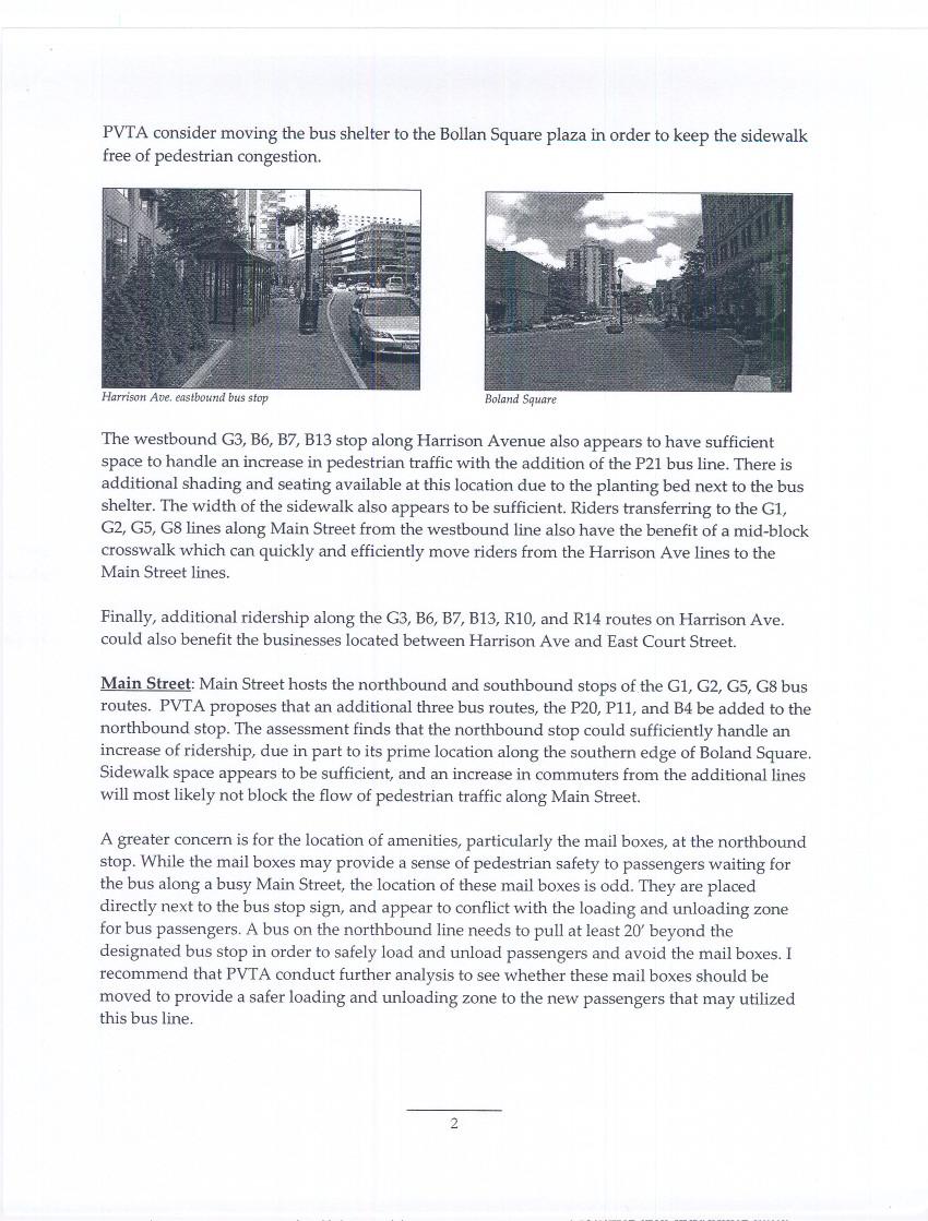
Main Street Bus Stops and Parking Study. Downtown Springfield, Massachusetts
|
|
|
- Horace Wilkinson
- 6 years ago
- Views:
Transcription


1 PVTA service on Main Street in downtown Springfield, Massachusetts Main Street Bus Stops and Parking Study Downtown Springfield, Massachusetts February 6, 2009 Prepared under the direction of the Pioneer Valley Metropolitan Planning Organization for the Pioneer Valley Transit Authority by the Pioneer Valley Planning Commission Funding assistance from the Pioneer Valley Transit Authority, the Massachusetts Executive Office of Transportation and Public Works, and the Federal Transit Administration
2 This page is intentionally blank Springfield Main Street Bus Stop and Parking Study 2 2/6/2009
3 TABLE OF CONTENTS Executive Summary... iii I. Study Purpose and Area... 1 II. Study Methods... 2 III. Findings... 3 A. Transit User Surveys Bus Stop Boardings and Alightings Bus Patron Survey Bus Stop Site Assessments Previous Studies... 6 B. Parking Inventory Method Parking Space Utilization Parking Turnover Illegal Parking in Bus Stops...10 C. Transit Operations Evaluation Optimization of Main Street Bus Stop Locations Relocation of Main Street Bus Stops to Other Streets D. Roadway and Pedestrian Capacity Assessment Main Street East Columbus Avenue Dwight Street IV. Analysis A. Transit B. Parking C. Transit Operations D. Roadway and Pedestrian Capacity V. Recommendations A. Recommendation 1: Maintain Bus Service on Main Street and Dwight/Chestnut Streets B. Recommendation 2: Optimize the Locations of Existing Main Street Bus Stops C. Recommendation 3: Encourage Improved Parking Conditions D. Recommendation 4: Study Strategies to Improve Left Turn Maneuvers at Signalized Intersections Appendices List of Preparers 2. Main Street Bus Stop Site Assessments Springfield Downtown Loop Study Springfield Downtown Bus Operations Evaluation 5. Parking Inventory Maps (7 maps) 6. Cost Estimate: Relocate PVTA Main Street Service to Alternate Streets 7. Bus Stop Signage 8. Bus Stop Zone Design Types 9. Manual of Uniform Traffic Control Devices Section 3B.21: Curb Markings 10. Guidelines for the Location and Design of Bus Stops Springfield Main Street Bus Stop and Parking Study i 2/6/2009
4 This page is intentionally blank Springfield Main Street Bus Stop and Parking Study ii 2/6/2009
5 Executive Summary The purposes of this study are to assess the effectiveness of the current locations of Pioneer Valley Transit Authority (PVTA) bus stops on Main Street in downtown Springfield between Lyman and Union Streets; evaluate the impact that parking patterns may have on traffic congestion; and offer recommendations to improve the transit service to downtown businesses, workers and residents. PVTA directed the Pioneer Valley Planning Commission (PVPC) to perform this study in response to concerns expressed in October 2008 by officials of the Greater Springfield Chamber of Commerce and City of Springfield that: 1) PVTA customers appear to be waiting for buses in front of Main Street businesses and obstructing building entrances, and 2) PVTA buses are slowing down vehicular traffic on Main Street. PVTA also agreed to address the issue of relocating bus stops from Main Street to East Columbus Avenue and other streets as part of the effort to address these concerns. Study findings are summarized below. Bus Stop Locations This study found that twice as many passengers use the bus stops between Bridge and State Streets than use the stops in the two other sections (Hampden to Worthington Streets, and Bliss to Union Streets) of the study area. This area also has the longest gaps between bus stops ranging from 265 to almost 400 yards even though industry standards recommend that stops be located every yards for optimum service in a central business district. The result is an imbalance between bus rider demand and the bus stops to serve that demand. PVTA customers were observed in general to be distinct from other pedestrians on Main Street. The majority of people congregating near building entrances did not arrive or depart by bus. Instead, bus passengers tended to wait near posted stops (or in shelters, where available). Bus riders were observed seeking shelter under awnings and in doorways during inclement weather. An evaluation of bus operations identified several opportunities to optimize bus stop locations and better balance rider demand with stop locations: Relocate the Fort Street southbound stop to 1550 Main Street (former Federal Building) with a new shelter. Eliminate the Taylor Street northbound stop. Relocate the 1350 Main Street southbound stop to Court Square and refurbish the existing shelter. Relocate the Falcons Way northbound stop to 1277 Main Street (MassMutual Center) with a new shelter that is aesthetically complementary to the location. These improvements could be accomplished at little cost, as there would actually be a net reduction of one stop (from 12 to 11), with expected gains in operational efficiency to improve traffic flow. New and refurbished shelters would encourage passengers to congregate at bus stops, rather than in doorways or under the awnings, especially during inclement weather. Springfield Main Street Bus Stop and Parking Study iii 2/6/2009
6 Notably, PVTA has already reduced by approximately half the number of buses traveling on Main Street south of Harrison Avenue/Boland Way by permanently adopting the alternate routes away from State Street followed by several PVTA lines during the construction of the MassMutual Center. PVTA acknowledges that regular cleaning and maintenance of all downtown shelters is essential and is committed to improving the appearance of these shelters. Parking This study found that a lack of parking enforcement on Main Street is creating conditions that contribute to traffic congestion. At least 78% of cars parked in legal spaces on Main Street were observed violating posted time restrictions. This greatly increases the utilization rate of legal spaces, which in turn leads to more illegal parking much of it in bus stops. In fact, an average of 8 cars per hour were observed blocking bus stops between Union and Lyman Streets. This means that on average, every bus traveling on Main Street in either direction encounters at least one blocked bus stop. Observers noted that the bus stops at 1350 Main Street and Falcon s Way were constantly blocked by illegally parked cars. Blocked bus stops are forcing buses to discharge and pick up passengers in the middle of Main Street, which delays all traffic. In-street boarding also puts the safety of passengers at risk, especially disabled people, who take the bus more often than the general population. This study recommends the following measures to resolve the parking problems that appear to be causing blocked bus stops: Increase turnover at legal parking spaces by creating more 15-minute and/or better time limiting of parking spaces. Increase parking enforcement along Main Street. Install pavement markings and improved signage to clearly mark bus stop pull-in areas. Relocation of Main Street Bus Stops Main Street is the most pedestrian-friendly of the north-south arteries in downtown and therefore the most well-suited to transit service. More than 75% of downtown bus riders surveyed oppose relocating Main Street bus stops to other streets. It would cost at least $279,000 more per year to operate current PVTA bus routes using alternate streets, an increase that would be assessed to the City of Springfield on the basis of additional miles traveled (79,000 miles per year), consistent with the funding formula for regional transit administration financing. Relocation of bus service to East Columbus Avenue would involve significant new capital costs to design and construct ADA-compliant pedestrian amenities, such as sidewalks, crosswalks and building entrances, as well as roadway reconfigurations for bus stops. Relocation of bus routes to other streets would require approximately 5,000 additional bus operating hours annually, resulting in increased air pollution emissions of volatile organic compounds (VOCs), nitrogen oxide (NOx), and carbon monoxide (CO). Relocating bus stops would disproportionately diminish access to downtown destinations for transit riders, who would be forced to walk further to reach Main and Dwight Streets, where the majority of employment and commercial buildings are located. A large Springfield Main Street Bus Stop and Parking Study iv 2/6/2009
7 percentage of transit users are low-income and/or minority residents; therefore, any reduction in transit access could jeopardize PVTA compliance with federal Title VI civil rights requirements for transit funds, as well as state and federal environmental justice standards. Public hearings would be required prior to such a change in service. The downtown Main Street corridor remains the transit spine of Springfield s urban core. This study offers findings and recommendations to further improve the functionality and efficiency of this vital transportation service. Next Steps A draft version of this report was presented to representatives of the Greater Springfield Chamber of Commerce, Springfield Business Improvement District, Springfield Parking Authority and Springfield Mayor Office on December 22, At follow-up meetings with these organizations on January 9 and January 21, 2009, representatives of these organizations stated support for the bus stop relocation recommendations and advised PVTA that property owners at the proposed locations also supported the recommendations. At the January 21 meeting, the Springfield Parking Authority announced several new initiatives, including the installation of parking meters on Main Street, to effectively address many of the parking concerns and recommendations in this report. The Springfield Parking Authority and PVTA are now cooperating to obtain the approval of the Springfield Traffic Commission and Springfield City Council to implement the bus stop recommendations. PVTA will present plans for the bus stop relocation recommendations at the April 6, 2009 meeting of the Traffic Commission, and City Council approval will be sought shortly thereafter. It is anticipated that work to locate the stops can begin in May Further, PVTA will conduct public outreach to raise awareness of the new $100 fine for parking in bus stops that was enacted by the legislature earlier this year. Also, PVTA has committed to a cleaning and maintenance program for all the new and existing bus stops and shelter structures in downtown. Springfield Main Street Bus Stop and Parking Study v 2/6/2009
8 I. Study Purpose and Area The purposes of this study are to assess the effectiveness of the current locations of Pioneer Valley Transit Authority (PVTA) bus stops in downtown Springfield on Main Street between Lyman and Union Streets; evaluate the impact that current parking patterns may have on traffic congestion; and offer recommendations to improve transit service to downtown businesses, workers and residents. PVTA directed the Pioneer Valley Planning Commission (PVPC) to conduct this study in response to concerns expressed in October 2008 by representatives of the Greater Springfield Chamber of Commerce and City of Springfield that: 1) PVTA customers appear to be waiting for buses in front of Main Street businesses and blocking building entrances, and 2) PVTA buses are slowing down vehicular traffic on Main Street. PVTA agreed to address the issue of relocating bus stops from Main Street to East Columbus Avenue and other streets as part of the effort to address these concerns. The study area is the Main Street corridor in downtown Springfield, Massachusetts, from the intersection with Lyman and Gridiron Streets south to Union Street, a distance of approximately three-quarters of a mile (see map: Study Area). This section of Main Street is the heart of downtown, home to many of the city s largest employers, civic buildings, transportation facilities and entertainment venues. Main Street has been the spine of the local street transportation network since the development of the street rail system more than a century ago. There are 12 bus stops in the study area that are served by multiple PVTA bus routes. These stops and routes serving them are shown below (from north to south): Bus Stop Location Southbound Routes Hampden St G1, G2, G3, G5, G8, B6, B7, B13, B17/15 Fort St G1, G2, G3, G5, G8, B6, B7, B13, B17/ Main (Monarch Place) G1, G2, G5, G8 Bliss St Howard St Taylor St Northbound Worthington St G1, G2, G5, G8 G1, G2, G5, G8 G1, G2, G3, G5, B6, B7, B13, B15/17, P11, R10, R14, G8 G1, G2, G3, G5, B6, B7, G8, R10, P11, B13, R14, B17/15, R27 Bridge St G1, G2, G3, G5, G8, B6, B7, R10, P11, R14, B13, B17/15 Harrison Ave Falcon Way (East Court St) Stockbridge St Union St G1, G2, G5, G8 G1, G2, G5, G8 G1, G2, G5, G8 G1, G2, G5, G8 Currently, there is an imbalance in the southbound number of stops (5 southbound stops versus 7 northbound), as well as their spacing (see page 10). Springfield Main Street Bus Stop and Parking Study 1 2/6/2009
9 II. Study Methods The following methods were employed for this study. Transit Bus rider boardings and alightings. Surveyors recorded the number of persons boarding and exiting buses during the peak ridership times at each of the 12 bus stops in the study area, as well as the direction (north, south, east or west) that persons walked after exiting buses. Bus patron intercept surveys. Surveyors recorded the responses of bus patrons at Main Street bus stops to gauge their reaction to the concept of relocating those stops to other streets. Bus stop site assessment. Surveyors documented conditions at each of the 12 bus stops in the study area and noted major trip generators near each. Visual and site assessments are shown in Appendix 2. Bus operations analysis. Bus operations personnel reviewed existing bus stop locations, ridership, and operational requirements to evaluate cost impacts for alternatives to Main Street transit service. Calculations are shown in Appendix 6. Review of previous studies. Parking Main Street parking utilization and turnover. An inventory of all legal and illegal parking spaces in the study area was produced. Survey staff then recorded all legal and illegal parking utilization at 30-minute intervals for an 11-hour period on Wednesday, November 19, Maps of parking spaces on Main Street are provided in Appendix 5. Review of previous studies. Springfield Main Street Bus Stop and Parking Study 2 2/6/2009
10 III. Findings This section presents the findings of the research conducted for this study: transit user surveys, a parking inventory, transit operations evaluation, and a roadway/pedestrian capacity assessment. A. Transit User Surveys This section presents the findings of the following four research efforts conducted to determine the preferences and travel patterns of transit users: Bus stop boardings and alightings, bus patron intercept surveys, bus stop site assessments, and previous studies. 1. Bus Stop Boardings and Alightings The figure below presents total boardings and alightings observed at each of the 12 bus stops during the two-hour morning peak (7:00 to 9:00 a.m.) and afternoon peak (3:00 to 5:00 p.m.) on typical weekdays, a total of four hours. Counts were recorded on weekdays from November 3 through November 24, 2008 (holidays and Election Day were excluded) for a total of 48 hours of observation. The figure presents all boardings and alightings recorded at each stop during the four hours of observation, as well as the percentage of all bus riders observed who used the stop (N=641). Main Street Peak Hour Bus Stop Use Hampden St SB % Boardings Taylor St NB % Alightings Fort St SB % Worthington St NB % Stop Location Bridge St NB Harrison Ave NB 1350 Main St SB Falcon Way NB % % 15.9% 18.4% Bliss St SB % Stockbridge St NB % Howard St SB % Union St NB % Riders Springfield Main Street Bus Stop and Parking Study 3 2/6/2009

11 In addition to the 48 hours of bus stop observation, supplemental daytime off-peak site observations were made at all 12 bus stop locations. These observations found that, similar to the peak period observations, bus customers appear to be a small proportion of all pedestrians during off-peak hours. Detailed assessments of each bus stop, including observations of passenger and non-passenger activity, are provided in Appendix Bus Patron Survey Transit users in the Main Street corridor were surveyed to assess potential customer interest and/or support for relocating bus stops. A patron intercept survey was conducted at Main Street bus stops and the Springfield Bus Terminal on December 15, 2008 from 7:45 A.M to 4:30 P.M. People waiting for the bus or exiting the bus were asked the following question: "Would you support or oppose relocating the bus stops off of Main Street in downtown?" 80% 75.7% 70% 60% 50% 40% 30% 20% 13.2% 11.1% 10% 0% Oppose Support N/A N= Bus Stop Site Assessments Site assessments of the 12 bus stops in the study area show a variety of conditions. Photographs and complete assessments are provided in Appendix 2. Bus stops are typically marked by a single sign. There are no pavement marks to delineate the actual area of the street where the bus is to pull over. In other cases, newspaper boxes, mailboxes, utility equipment or street furniture may obstruct curbside boarding areas. This can lead to the bus having to overshoot standing passengers to find a safe place to stop. At right is an example of this Springfield Main Street Bus Stop and Parking Study 4 2/6/2009

, which increases conflict between bus customers waiting to board and pedestrians passing by.")
12 is at Harrison Avenue northbound. In such case, bus passengers must walk and re-queue at the bus door, which lengthens dwell times. The lack of clear bus stop markings may also contribute to the frequently observed instances of illegal parking in bus stops. Few stops have benches and other amenities. Only one stop in downtown has a shelter (Bridge Street). Several stops have narrow sidewalk widths (15-20 feet), which increases conflict between bus customers waiting to board and pedestrians passing by. In some cases, newspaper boxes, mail boxes, traffic signal control units and traffic signal poles block the convenient access to buses. An example of this problem is seen in the photo of 1350 Main Street at right. This is a mid-block stop, which requires extra space for buses to pull in (as opposed to the preferred nearside or far-side of block stops at other locations). Illegal blocking of bus stops compounds this problem. Significantly, bus riders were observed to be in general distinct from other groups of congregating pedestrians and passersby on downtown streets. Bus patrons tended to wait for their buses near the posted stop or in shelters where available. Other pedestrians pass by and do not interact with bus patrons. In addition, some pedestrians, many of whom arrived by private auto, congregated around the entrances of convenience stores and service-oriented establishments. These groups were noted during late morning and early afternoon hours, generally outside the morning and afternoon peak travel times. At right, an example of nonpassenger congregation is seen at Hampden Street. Springfield Main Street Bus Stop and Parking Study 5 2/6/2009
13 4. Previous Studies Two previous studies of transit use in the Main Street corridor offer findings that are relevant Downtown Springfield Transit Study. This report was produced following the implementation of a one-way restriction on Main Street to northbound traffic only between State and Liberty Streets. This restriction involved numerous operational changes to PVTA bus services, key among them was the relocation of the central downtown pulse point for transfers from the Springfield Bus Terminal to Harrison Avenue. Most buses were then required to follow a Downtown Loop along Dwight Street to East Court Street and back onto Main Street, increasing travel times. Bus patrons also had to walk to Dwight Street to access outbound buses. An onboard survey of bus patrons on downtown routes, as well as people waiting at downtown bus stops, found overwhelming dissatisfaction with the Downtown Loop service. A total 65% of all persons surveyed opposed the new configuration and removal of service from Main Street. Significantly, 3 of every 4 riders on north-south routes opposed the change; opposition among riders traveling on east-west routes was 51%. (Full report included as Appendix 3.) 2006 Report to PVTA and Springfield Department of Public Works. This study examined opportunities to optimize bus stop locations and routes in the Main Street corridor by increasing the use of Harrison Avenue as a pulse point for transfers among PVTA downtown lines (thus reducing PVTA s use of the Springfield Bus Terminal). This 2006 study provides several relevant findings: Illegal parking of private autos and delivery vehicles was degrading bus operations by requiring buses to stop in the travel lane to allow passengers to board and alight. An additional southbound stop in the vicinity of Harrison Avenue was desirable to spread out passenger loadings in this high-volume area. Bus operations would be less efficient, as bus layovers between scheduled runs could not take place near the proposed pulse point, resulting in additional operational costs. Existing capacity of on-street bus shelters and waiting areas at and near Harrison Avenue is sufficient to accommodate additional riders. (Full report is included as Appendix 4.) Springfield Main Street Bus Stop and Parking Study 6 2/6/2009
14 B. Parking Inventory An inventory of parking on Main Street performed for this study found that an average of 8 bus stops on Main Street are blocked by illegally parked cars every hour. This means that every bus traveling Main Street can expect to encounter at least one blocked bus stop between Gridiron and Union Streets. Blocked bus stops result in delays to all traffic, as buses must block the travel lane to allow passengers to board and alight in the middle of the street. Such in-street boarding also poses significant safety concerns, especially for disabled passengers who use mobility assistance devices that require curb cuts. The encroachment of illegal parking in bus stops is likely the result of the high utilization of legal parking, as well as the apparent lack of enforcement of time restrictions at free legal and metered parking street spots. A day-long parking inventory conducted for this study found that 78% of cars parked in legal spots on Main Street are violating the posted time limits, resulting in a lack of turnover at legal spots. As a consequence, a spillover effect is driving up the number of illegally parked vehicles in bus stops and causing traffic congestion. 1. Method An inventory of all legal and illegal parking spaces on Main Street between Gridiron and Union Streets was performed to: 1) gather information on the existing parking supply; 2) gather observations of the number of parking spaces; and 3) ascertain compliance with posted time restrictions. To conduct the inventory, the study area was divided into two routes each containing an average of 10 blocks. The two areas were: the north side of Main Street in the City of Springfield from Union Street to Lyman Street (Observer Route 1) and the south side of Main Street from Gridiron Street to Union Street (Observer Route 2). Data was collected on November 19, 2008 from 7:30 AM to 6:30 PM. Accumulation checks (occupancy) and license plate checks (turnover rates) were collected for the 11-hour study period. Parking accumulation is the total number of vehicles parked at a given time. The purpose of accumulation checks is to establish hourly variations and peak parking demand. The information for the occupancy study was gathered by two surveyors who walked Observation Routes 1 and 2 respectively. Surveyors referenced maps and field sheet tables, which contained the location and number of legal and potentially illegal parking spaces of each parking block within the route. The number of parked cars was recorded on field sheet tables at 30-minute intervals. License plate checks were used to observe turnover rates. In this study, turnover rate was defined as the amount of time that one vehicle occupied a unique parking space. Turnover rates were determined by recording the last three digits of the vehicle license plate at each unique parking space. This data was collected every 30 minutes throughout the 11-hour observation period to gauge the length of time that vehicles occupied legal and illegal parking spaces. 2. Parking Space Utilization Parking usage varies throughout the day. Therefore, utilization percentages were calculated using the information collected for three periods: 7:30 AM through 11:00 AM; 11:00 AM through 3:00 PM; and 3:00 PM through 6:30 PM. There are a total of 117 legal spaces available on Main Street from Gridiron Street and Union Street. The figures below present the average utilization of Springfield Main Street Bus Stop and Parking Study 7 2/6/2009
15 legal spaces during the day on the east and west sides of Main Street; blocks are delineated by the name of the cross street first encountered in the direction of travel. These figures show that the highest utilization of legal parking spaces occurs from 11:00 AM to 3:00 PM. For example, the east side of the block between Falcons Way and Harrison Avenue provides a total of 14 parking spaces reaching an average of 77% utilization during this time period. Similarly, the block between Harrison Avenue and Court Street provides 14 legal parking spaces and reaches a utilization average of 88% within the same time period. Ave. Legal Parking Space Utilization West (SB) Side of Main St Average Legal Parking Space Utilization East (NB) Side of Main St 7:30 AM to 11:00 AM 11:00 AM to 3:00 PM 3:00 PM to 6:30 PM Howard St Bliss St State St Court St Harrison Ave Bridge St Hampden St Gridiron St 30% 40% 50% 54% 52% 69% 66% 60% 69% 65% 78% 69% 79% 62% 64% 61% 81% 88% 83% 92% 92% 79% 88% 68% 0% 20% 40% 60% 80% 100% Lyman St Taylor St Worthington St Bridge St Harrison Ave Falcons Way Cross St 7:30 AM to 11:00 AM 11:00 to 3:00 PM 3:00 PM to 6:30 PM Park St 50% 69% 66% 68% 54% 68% 57% 54% 55% 63% 50% 57% 63% 71% 77% 81% 71% 75% 86% 70% 68% 77% 66% 94% 0% 20% 40% 60% 80% 100% Springfield Main Street Bus Stop and Parking Study 8 2/6/2009

16 Below is a display of this data as averaged for the full day and plotted on a map of the study area. The average utilization rates are shown at right. 70% BOLAND WAY HARRISON AVE 71% 62% 3. Parking Turnover Turnover rates were recorded for all legal and illegal parking spaces on Main Street. The table below reports the proportion of vehicles parked in legal spaces that violated the two-hour parking restriction. As seen below, a total of 91 vehicles were recorded violating the posted parking time restrictions. In fact, more than a dozen vehicles parked in legal 2-hour spaces did not move for Springfield Main Street Bus Stop and Parking Study 9 2/6/2009
17 8 hours or longer. In all, 78% of the vehicles parked in legal spaces on Main Street violated the posted time restrictions. 4. Ille gal Pa rki ng in Bu s Sto ps Cit y of Spr ing fiel d Main Street Vehicle Parking Turnover: Legal Spaces Vehicles Parked in Legal Spaces Exceeding Posted Time Restrictions 8 12 TOTAL: 91 cars (78%) parked in legal spaces violated posted time restrictions Hours Parked in One Legal Space parking laws designate bus stops as no parking zones. A total of 91 vehicles (more than 8 per hour) were observed parking illegally in bus stops during the 11-hour data collection period. However, unlike the 78% of cars in legal spaces that overstayed the 2-hour time limit, none of the illegally parked vehicles stayed more than 30 minutes in a bus stop or other illegal spot. This suggests illegal spaces are being used mainly for short errands. The impact of illegal parking on traffic congestion is significant. If one assumes that each car illegally parked in a bus stop is there no longer than 15 minutes, this means there would be at least one northbound stop blocked every 10 minutes and one southbound stop blocked every 12 minutes. Therefore, every bus traveling on Main Street (in either direction) can expect to encounter an average of at least one blocked bus stop that they cannot pull into. This forces the bus to pick up and discharge passengers from the travel lane, which stops all traffic behind the bus. Surveyors observed illegally parked cars most frequently in the following bus stops: 1350 Main Street, Falcons Way, and Fort Street. C. Transit Operations Evaluation Management and operations personnel of PVTA s bus operating unit for Springfield, the Springfield Area Transit Company (SATCo), analyzed current Main Street bus stop locations, as well as an alternative to relocate Main Street bus stops to other streets. Results are presented below. 1. Optimization of Main Street Bus Stop Locations Springfield Main Street Bus Stop and Parking Study 10 2/6/2009
18 Ridership, operations, transfers, parking concerns and driver knowledge of the corridor were weighed to assess the feasibility and desirability of existing Main Street bus stops. The results of this analysis are shown below. Operational Priority (last column on right) reflects a balance of operational considerations. Main Street Bus Stop Operational Evaluation Stop Location Distance to next stop* Queuing Area Transfer Proximity Considerations Operational Priority Southbound Hampden St. SB 65 yds Good No First SB stop after SBT. Frequent illegal parking. Fort St. SB 395 yds Limited No Turn lane conflicts with SB vehicles turning right Main St. SB 365 yds Limited No Mid-block stop is safety concern (no crosswalk). Curbside obstructions; frequently blocked. Bliss St. SB 101 yds Good No Good queuing area and pairing with Stockbridge NB. Howard St. SB Northbound Taylor St. NB Worthington St. NB 300 yds (Williams St) 200 yds (SBT) Medium Low High Medium Limited No Minor right turn conflict. Medium Good No Last NB stop before SBT. Awkward left turn required onto Hampden for some routes. 95 yds Limited No Numerous ADA customers at Worthy Apartments. Medium Bridge St. NB 105 yds Excellent No Bus shelter, landscaped park. High Harrison Ave. NB 170 yds Excellent Yes Short walk (100 ft) to outbound stop for east-west routes. Key transfer point. Street furniture blocks boarding. Falcon Way NB 155 yds Limited Yes ADA access to PVTA Info Center. Frequently blocked by illegal parking. Short bus pull-in area. Stockbridge St NB 263 yds Good No Low ridership. Paired with Bliss St SB. Union St NB 238 yds Limited No Narrow sidewalk. Private awning provides shelter. High High High Medium High * in travel direction This analysis shows an apparent imbalance in the number of southbound stops in the mid-section of the Main Street corridor the location where customers are boarding and alighting to make Springfield Main Street Bus Stop and Parking Study 11 2/6/2009

19 transfers to and from east-west routes. Significantly, the distances between the Fort Street and 1350 Main Street southbound stops are close to 400 yards (approximately one-quarter mile). This information is presented below along with the bus stop use results presented in Section A. 1. It is important to note that in prevailing transit industry practice, the preferred bus stop gap distance in a central business district is 200 yards. DWIGHT STREET 21.1% of riders 400 yard gap E. COLUMBUS AVE 14% BOLAND WAY 18% HARRISON AVE 56.3% of riders 16% 365 yard gap 263 yard gap 9% 8% 22.5% of riders = 5% of all riders observed 2. Relocation of Main Street Bus Stops to Other Streets A bus operations evaluation was also performed to assess the feasibility and potential operational advantages of relocating bus stops from Main Street to other downtown arterials. This analysis Springfield Main Street Bus Stop and Parking Study 12 2/6/2009
20 found that the existing Main Street and Dwight Street/Chestnut Street routes offer the most direct routes for PVTA service in downtown. Use of other nearby streets would result in approximately 79,000 miles per year of additional travel to downtown bus routes. The additional mileage would add about 16 hours per day to bus operations, or 4,896 of additional vehicle operating hours per year. This would also have a negative impact on air quality as the increase in operating hours for PVTA buses would result in increases in volatile organic compounds (VOCs), nitrogen oxide (NOx) and carbon monoxide (CO) emissions. The additional mileage and operating hours mean that the cost to relocate the existing bus stops on Main Street to East Columbus Avenue and/or Dwight/Chestnut Streets would be approximately $279,000 per year. The basis for this estimate is SATCo s FY2009 operating costs in the Springfield area service ($40 per bus operating hour and $1.05 per mile) and the assumption that existing levels of service will be maintained year round. This estimate includes the cost of the additional buses that would be necessary to maintain the existing G2 schedule, as well as extra helper buses necessary to maintain existing schedules (see Appendix 6). However, the actual cost of relocating bus stops from Main Street could very well be higher, as the exact routes and additional operating hours needed to serve any new or relocated bus stops from Main Street (or the level of delay that would be caused by some of the additional turning movements) cannot be known without a more detailed operations analysis. Further, relocation of bus service to East Columbus Avenue would require significant capital costs to design and construct ADA-compliant pedestrian amenities, such as sidewalks, crosswalks and building entrances that do not currently exist on this street. Springfield Main Street Bus Stop and Parking Study 13 2/6/2009


21 D. Roadways and Pedestrian Capacity Assessment Transit usage depends on the ability of pedestrians to access routes and services. A walkable, pedestrian-friendly environment is essential for successful transit operations and reducing demand for private autos. This section offers a brief analysis of the general pedestrian environment surveyed on the three principal north-south arteries in the Main Street area: Main Street, East Columbus Avenue, and Dwight Street. 1. Main Street Main Street has historically been the transit spine of downtown since the development of street rail in the 1900s. Setbacks range from approximately 20 to 50 feet, offering sufficient sidewalk widths for comfortable pedestrian passage. On wider sidewalks, there is typically some pedestrian congregation, depending on time of day and weather. Main Street is two lanes in each direction. There are seven signalized intersections in the study area. Traffic volumes on Main Street (at Emery Street) are approximately 12,000 vehicles per day (MHD 2006). Near the middle of the study area, Town Square, Monarch Place and other large buildings are major trip generators. Street furniture and landscaping provide a welcoming pedestrian environment in several areas of the Main Street corridor. In the northern part of the study area, short setbacks and traditional storefronts create pedestrian interest (and provide shelter, especially during inclement weather). Near Union Street, storefronts are also close to the street, with awnings and architectural details. Springfield Main Street Bus Stop and Parking Study 14 2/6/2009
 Pedestrian amenities are limited or absent between Bridge and State Streets; in fact, there are no sidewalks along some portions of the road.")


22 2. East Columbus Avenue East Columbus Avenue is the principal north-south artery to the west of Main Street. It is a north-bound, two- to three-lane one-way arterial next to the viaducts of I-91. (West Columbus Avenue is on the west side of the highway.) Pedestrian amenities are limited or absent between Bridge and State Streets; in fact, there are no sidewalks along some portions of the road. There is little scaling or orientation of structures to the street. One of the principal features is the entrance to the Tower Square parking ramp. Traffic volumes range from 9,000 to 12,000 vehicles per day. As it exists currently, East Columbus Avenue is wholly unsuited for effective transit service. In fact, relocation of bus stops from the more pedestrian accessible locations on Main and Dwight Streets could jeopardize Title VI civil rights eligibility and compliance necessary for federal transit funds, as this reduction in access would disproportionately affect transit riders, a majority of whom are low-income and/or minority residents. Seen above is the entrance to the Town Square parking ramp, which is the rear of the building. This structure blocks pedestrian egress and passage along the street. There are no parking lanes along this section of East Columbus Avenue. Bus operations to pick up passengers on this street configuration would cause vehicle backups and degrade traffic safety without significant roadway reconfiguration. Some sections along East Columbus Avenue have no sidewalk; pedestrians must use this dirt path instead. One measure to improve pedestrian access along East Columbus Avenue is seen above: a bridge to take the pedestrians off the street. Springfield Main Street Bus Stop and Parking Study 15 2/6/2009


23 3. Dwight Street In the study area, Dwight Street is one-way southbound with two travel lanes and a lane of parking on either side. Curb space is provided for bus stops and there are wide sidewalks on both sides of the street. Traffic volumes are 11,000 to 12,000 vehicles per day. There are sidewalks the entire length of the street; however, there is a grade separation between Dwight and Main Streets that could pose difficulties to transit customers with mobility impairments. Building scale and orientation to the street and pedestrian environment is varied: there are several large structures, such as parking lots, as well as storefront businesses. There are four signalized intersections between Lyman and State Streets. PVTA east-west routes R10, R14, B6, B7, B15/17, as well as north-south route G3 travel along portions of Dwight to collect downtown passengers for their runs. Bus stop at Dwight Street and Falcons Way is seen above. The parking garage reduces pedestrian appeal along this block. Dwight Street at Harrison Avenue, where parking lots and larger buildings reduce the attractiveness of the area to pedestrians. Dwight Street at Worthington. There is ample street width for on-street parking on both sides, as well as bus stops (currently used by up to five PVTA routes). Dwight Street at Taylor Street (State Office Building seen at left). Crosswalks with signals offer pedestrians safety along this portion of the corridor, but there is relatively little street furniture. Springfield Main Street Bus Stop and Parking Study 16 2/6/2009
24 IV. Analysis Following is a summary of the key findings of the transit user surveys, parking inventory, transit operations evaluation, and roadways and pedestrian capacity assessment performed for this study: Main Street has the most well-developed pedestrian environment of downtown northsouth arterial streets, which is essential for effective and efficient transit operations. It would cost at least $279,000 more per year to provide current levels of service using streets other than Main Street, plus undetermined capital costs for design and construction of comparable pedestrian facilities on East Columbus Avenue. Relocating service to East Columbus Avenue would require an additional 5,000 hours of bus operations, increasing air pollution emissions. More than 75% of riders surveyed support keeping bus stops on Main Street. The existing spacing of southbound bus stops on Main Street is not well matched to rider demand, especially between Bridge and State Streets where transit user demand is heaviest but the stops are furthest apart. The blocking of bus stops by illegally parked cars is contributing to traffic congestion by forcing buses to stop in the travel lane to load and unload passengers in the street. Discussion follows. A. Transit An imbalance exists between passenger demand and the spacing of southbound bus stops in the central section of the study area. Bus stop use is heaviest between Bridge and State Streets, yet the distance between southbound stops is three to four times greater (300 to 400 yards) than the northbound stops. This increases the distance that riders who need to transfer to PVTA east-west routes at Harrison Avenue and Boland Way must walk, which diminishes transfer convenience. This also disrupts the intuitive pairing of northbound and southbound stops, which is desirable to help simplify the overall route system. The overwhelming preference of riders surveyed at Main Street bus stops (75.7%) was to retain bus stops on Main Street. Significantly, any relocation of bus service from Main Street to Columbus Avenue could disproportionately affect Environmental Justice (minority and lowincome) populations. PVTA s December 10, 2008 report on the survey of riders in this service region found that more than half (55%) of bus riders report an annual income of $10,000 per year or less, which indicates they likely belong to a household living at or below the poverty level. The operational evaluation of the 12 bus stops in the study area found opportunities to relocate and consolidate operations to improve travel times, efficiency and safety. The site assessment also found that bus passengers are usually distinct from other pedestrians who congregate on downtown streets. Bus passengers tend to wait for their bus near the posted stop location. Pedestrians with other business tend to arrive by private auto or bike and congregate near the entrances to convenience stores and service-oriented businesses. Springfield Main Street Bus Stop and Parking Study 17 2/6/2009
25 B. Parking The high long-term utilization of legal parking spaces resulting from the lack of enforcement of posted time restrictions is driving up demand for short-term parking spaces on Main Street. The result is increased demand and utilization of illegal parking spaces (many of which are in bus stops) for short-term parking. Bus stops are not always well-marked by signage; there are no street markings to clearly show bus stops, whereas some metered parking areas are delineated by street markings. In addition, many illegally parked cars were observed in pedestrian crosswalks, which are very well-marked. Crosswalks are important for the safety of all pedestrians, including bus customers. Both circumstances degrade pedestrian safety, which is important to traffic flow and bus operations. C. Transit Operations One significant cause of traffic congestion on Main Street is illegal parking in bus stops. The combination of high demand for legal spots and unmarked bus pull-over areas appears to be causing the blockage of bus stops (an average of 8 per hour), which forces buses to block all traffic to pick up and unload passengers in the travel lane. The operational evaluation found that the lack of pedestrian facilities, including sidewalks, on alternate routes to Main Street would create concerns related to safety and compliance with the Americans with Disabilities Act (ADA) and Title VI Civil Rights. In addition, moving service to other streets would cost at least $279,000 more per year, which would be assessed to the municipality receiving the service (City of Springfield) under the Commonwealth s formula for regional transit authority funding. Public hearings as part of a federally required local public involvement process to solicit and consider public comment prior to any fare increase or major service reduction described in 49 CFR Section 5307(d)(1)(I) would be necessary before this change of service could be implemented. PVTA recently optimized bus operations on Main Street by retaining the use of Harrison Avenue by several bus routes that were diverted from their original State Street/Main Street routes during the 2006 construction of the Mass Mutual Center. The retaining of this construction phase detour has actually reduced by approximately half the number of buses traveling on Main Street south of Harrison Avenue/Boland Way today. Also, many bus patrons find this routing convenient. D. Roadway and Pedestrian Capacity Main Street is currently handling traffic volumes that are comparable to those of similarly classified parallel arterial roads (East Columbus Avenue and Dwight Street). However, Main Street offers a significantly more pedestrian friendly environment, which is critical for successful transit service. Relocation of transit service to East Columbus Avenue and other streets would require substantial new investment in sidewalks, crosswalks, improved building access and travel lane configurations to achieve the same level of service that is already available on Main Street. The capital costs for design and construction of these facilities would require additional study, but would likely be significant (on the order of $500,000 to $1 million or more). Additional study of these potential costs is necessary. One additional factor observed contributing to traffic congestion on Main Street are delays caused by vehicles making left turns at some cross streets (i.e., Hampden Street). Springfield Main Street Bus Stop and Parking Study 18 2/6/2009
26 V. Recommendations A. Recommendation 1: Maintain Bus Service on Main and Dwight/Chestnut Streets Maintain existing bus service on Main Street and Dwight/Chestnut Streets. This recommendation involves no additional cost; does not jeopardize compliance with Title VI Civil Rights requirements of federal agencies for transit funding; and does not increase air pollution emissions. B. Recommendation 2: Optimize the Locations of Existing Main Street Bus Stops This recommendation involves three stop relocations and one stop deletion to achieve a spacing of bus stops that better balances passenger demand and stop availability in the central section of the study area. Under this recommendation, the number of stops on Main Street is reduced from 12 to 11, with no changes to routes or operations. Implementation costs would therefore be minimal. Relocated stops would be located positioned consistent with bus stop street-side factor guidelines (see Appendix 8). Recommendation Basis Actions 2A: Relocate Fort St. SB stop to 1550 Main St. (former Federal Bldg) Fort St SB is one of the most infrequently used stops in the study area. There are frequent illegal parking conflicts, as well as a right turn lane conflict. Fort St is just 65 yards south of the Hampden St SB stop, which has a considerably better passenger queuing area. The 375-yard distance between the Fort St and 1350 Main St SB stops is not balanced to passenger demand. It also reduces transfer convenience to eastwest routes at Harrison Ave. This location would also help create a pairing with the Bridge St NB shelter, which is one of the most attractive stops in downtown. Relocate the Fort St SB stop to a nearside location on the 1550 Main St. block. Install a shelter at the new stop location to help create visual pairing with the Bridge St. shelter. 2B: Remove Taylor St. NB stop This stop is among the most infrequently used northbound. Several routes that currently stop here must then make an immediate left turn onto Hampden Street. Eliminate Taylor St. NB stop. Post signage to direct patrons to Worthington St. NB stop or SBT. 2C: Relocate 1350 Main St. SB stop to Court Square 1350 Main St. SB is a mid-block stop with several street furniture obstructions. It is also frequently blocked by illegal parking. There is no mid-block crosswalk for passengers. The queuing area is between two large buildings that create a wind-tunnel. The relocation of Fort St. SB to 1550 Main St. (Recommendation 2A above) would reduce the gap Remove 1350 Main St. stop. Refurbish Court Square shelter and relocate stop to this location. Contingent on Recommendation 2A. Consider Court St. nearside location as an alternative (see Appendix 8 for Springfield Main Street Bus Stop and Parking Study 19 2/6/2009
27 2D: Relocate Falcons Way northbound stop to 1277 Main Street (MassMutual Center) between these stops, allowing the 1350 Main St. stop be moved 140 yards south to Court Square without sacrificing customer convenience. Parking demand on Main St. is typically less than at Court Square, thereby improving bus operations. Significantly, there are at least half as many buses traveling this section of Main St. since 2006, when revised routings for several east-west routes during construction of MassMutual Center were permanently adopted. Bus customers appreciate the convenience of this stop to the PVTA Information Center. However, the combination of a short bus pull-in area and aggressive illegal parking in this stop mean that boardings and alightings in the travel lane are frequent at this stop. Not only does the discharge of passengers in the middle of the street delay cars and other buses, but it also creates accessibility problems (especially in winter months) for the many disabled PVTA customers who travel to this stop to pick up their monthly passes. Furthermore, the sidewalk at the existing stop is relatively narrow (15-20 ft.) and offers little space for passenger queuing. In contrast, there is an ample queuing area just 50 yards to the south on the 1277 Main St. block. In this case, the safety of Info Center customers would outweigh the minor inconvenience of walking an additional 50 yards to the service counter. recommended pull-in dimensions). Relocate Falcons Way NB stop to a nearside location on the 1277 Main St. block (MassMutual Center). Coordinate with City and property owner for appropriate shelter and signage and amenities. Ensure that signage directing PVTA customers to the Info Center is included at the relocated stop. As an alternative, consider lengthening the existing farside stop to at least 90 ft. (see Appendix 8). (See overleaf: Map of Main Street bus stop optimization recommendations.) Springfield Main Street Bus Stop and Parking Study 20 2/6/2009
28 C. Recommendation 3: Encourage Improved Parking Conditions The following recommendations are offered to reduce traffic congestion by increasing the turnover at legal parking spaces and reducing illegal parking in bus stops. Recommendation Basis Actions 3A: Increase turnover rate at legal parking spaces High demand for legal parking spaces is heightened by lack of enforcement of time restrictions to encourage turnover. A total 78% of cars parked at legal spaces were observed violating the posted time restrictions. This increases demand for illegal parking spaces, including bus stops. The August 2005 Infrastructure Management Report to the Springfield Parking Authority identified increased on-street enforcement as a key strategy for increasing revenue from parking operations. Improve enforcement of time restrictions at legal parking spaces. Consider creating more 15-min and/or metered parking spaces on Main St. Publicize currently available savings for long-term parking at Springfield Parking Authority facilities. Conduct public and media outreach to publicize preferred parking areas, including awareness of the safety hazards and ADA compliance issues associated with illegally blocked bus stops. 3B: Increase enforcement at illegal parking spaces A total of 91 cars, (more than 8 cars per hour) were observed parking illegally in bus stops. This means that, on average, every bus traveling Main Street encounters at least one blocked bus stop. Blocked stops contribute to traffic congestion and diminish the safety of bus passengers, especially those with ADA needs. Prioritize bus stops for parking enforcement. Inventory and improve parking signage (see Appendix 7). Consider options for giving authority to PVTA supervisors to issue tickets to cars that are illegally blocking bus stops (this is a practice of Connecticut Transit in some locations). 3C: Mark bus stop pullin areas clearly on pavement; improve signage One likely contributor to the high rate of illegal parking in bus stops is the lack of pavement markings and signage to clearly delineate bus stops. Clear pavement markings would aid in parking enforcement, especially photo documentation of violations. Also, pavement markings would also aid passengers in queuing for boarding, as well as alighting. Use pavement markings consistent with existing pedestrian crosswalk markings to outline rectangles marking bus pull-in areas. Review and improve bus stop and parking signage (see Appendix 7). Paint curbs to designate No Parking areas consistent with Manual of Uniform Traffic Control Devices Section 3B.21 (see Appendix 9). Springfield Main Street Bus Stop and Parking Study 21 2/6/2009
29 D. Recommendation 4: Study Possible Strategies to Improve Left Turn Maneuvers at Signalized Intersections Another observed cause of traffic congestion on Main Street are the delays experienced by all vehicles (including buses) making left turns at Hampden Street when forced to wait for oncoming traffic to clear the intersection. This delays all vehicles behind the waiting vehicle. It is recommended that the City of Springfield consider further study of potential signalized traffic improvements on Main Street, such as a brief protected green phase (similar to that implemented on Page Boulevard) for this location, as well as other intersections in the study area that are experiencing similar operational delays. Springfield Main Street Bus Stop and Parking Study 22 2/6/2009
30 Appendices 1. List of Preparers This report was prepared by: PVPC David Elvin Dave Johnson Amir Kouzehkanani Kelvin Molina Gary Roux Dana Roscoe Jim Scace Additional PVPC Survey Personnel Andrew McCaul Jeff McCollough Khyati Parmar James Intern SATCo Tom Narrigan Ellen Grant Peter Jones Jean Wheeler Downtown Springfield Main Street Bus Stops Site Assessment. Pioneer Valley Planning Commission Downtown Springfield Transit Study. Pioneer Valley Planning Commission Report to PVTA and Springfield Department of Public Works. Pioneer Valley Planning Commission. 5. Parking Inventory Maps Cost Estimate: Relocate Main St PVTA Service to Alternate Streets. Springfield Area Transit Company. 7. Bus Stop Signage Examples 8. Bus Stop Zone Design Types 9. Manual of Uniform Traffic Control Devices Section 3B.21: Curb Markings (2004) 10. Transportation Cooperative Research Program Report No. 19: Guidelines for the Location and Design of Bus Stops National Academies, Washington DC. Springfield Main Street Bus Stop and Parking Study 23 2/6/2009
 Sign condition: Good Pavement condition: Good Lighting: 1 street light Shelter: None Parking: Illegal parking frequently observed (see photo) Trip generators: Heating assistance office, Graham s")

31 Appendix 2: Bus Stop Site and Visual Assessment Location: Main and Hampden Streets Direction: SB Routes: G1, G2, G3, G5, G8, B6, B7, B13, B17/15 Sidewalk width: 35 (approx.) Sign condition: Good Pavement condition: Good Lighting: 1 street light Shelter: None Parking: Illegal parking frequently observed (see photo) Trip generators: Heating assistance office, Graham s convenience and package store, professional offices Notes: A wide sidewalk provides sufficient area for bus rider queuing and pedestrian passage. Frequent non-passengers arrive by private auto, bike or foot and tend to congregate near storefronts and building entrances. Nonpassengers, many of who are students (depending on time of day), often call to others across the street. Bus passengers tend to wait quietly near the bus stop sign at the curb. Location: Main and Taylor Streets Direction: NB Routes: G1, G2, G3, G5, B6, B7, B13, B15/17, P11, R10, R14, G8 Sidewalk width: 15 (approx.) at bldg; 35+ at nearside curb area Sign condition: Good Pavement condition: Good Lighting: 2 street lights Shelter: None (small park provides queuing area). Parking: Some illegal parking observed. Trip generators: Neighborhood Assistance Corp., other multi-story apartment buildings Notes: Frequent conflicts with non-pvta ADA vans, delivery vehicles and private autos in bus stop. Few users or non-passengers congregating. Appendix 2-1
 Sign condition: Good Pavement condition: Good Lighting: no nearby streetlight Shelter: None Parking: Illegal parking in bus stop observed.")

32 Appendix 2: Bus Stop Site and Visual Assessment Location: Main and Fort Streets Direction: SB Routes: G1, G2, G3, G5, G8, B6, B7, B13, B17/15 Sidewalk width: 15 (approx.) Sign condition: Good Pavement condition: Good Lighting: no nearby streetlight Shelter: None Parking: Illegal parking in bus stop observed. Trip generators: Student Prince, Command Security, various service businesses (beauty salon), offices on upper floors. Notes: Nearside stop is very close to intersection, creating conflicts with other vehicles turning right; safety concern for riders exiting buses and crossing street. Buses frequently pick up and discharge in travel lane. No immediate crosswalk to east side of Main. Passengers tend to congregate under Student Prince awning for shelter, creating conflicts with passersby. Relatively few non-passenger pedestrians congregating at stop, but groups of 6-12 students congregate further up the block, depending on time of day. Location: Main and Worthington Streets Direction: SB Routes: G1, G2, G3, G5, B6, B7, G8, R10, P11, B13, R14, B17/15, R27 Sidewalk width: 15 (approx.) Sign condition: Good Pavement condition: Good Lighting: 1 street light Shelter: None Parking: ADA vans at Worthy Apartments Trip generators: Jake s City Café, 7-story Worthy Apartments, offices Notes: Groups of non-passengers tend to congregate near Worthy Apartments entrance and turnaround loop. Narrow sidewalk width and street furniture creates conflicts between waiting passengers and passersby. Frequent ADA pick ups at Worthy Apartments block bus stop. Appendix 2-2


 Parking: frequent illegal parking observed Trip generators: Main downtown transfer point to eastwest bus routes; major")
33 Appendix 2: Bus Stop Site and Visual Assessment Location: Main and Bridge Streets Direction: SB Routes: G1, G2, G3, G5, G8, B6, B7, R10, P11, R14, B13, B17/15 Sidewalk width: 35+ (approx.) Sign condition: Good Pavement condition: Good Lighting: 2 street lights Shelter: Yes (only shelter on Main St) Parking: No illegal parking observed Trip generators: Tower Square, 1550 Main St, CVS, service-oriented storefront businesses Notes: One of Main Street s most attractive stops. No opposite side pairing. Little rider/passerby conflict. Pedactivated walk signal. System map/schedule holder. Location: Main Street and Harrison Avenue Direction: SB Routes: G1, G2, G5, G8 Sidewalk width: 25+ (approx.) Sign condition: Good Pavement condition: Good Lighting: 2 street lights Shelter: None (shelter at Harrison Ave outbound; see photo at lower right) Parking: frequent illegal parking observed Trip generators: Main downtown transfer point to eastwest bus routes; major financial employers. Notes: Mail/courier and newspaper boxes blocks bus boarding/alighting. Often windy. Appendix 2-3
 Sign condition: Good Pavement condition: Good Lighting: Street light Shelter: None (very windy) Parking: constant illegal parking observed (private autos and delivery vehicles Trip generators: City")

 frequent rider/passerby conflicts Sign condition: Fair (blocked by foliage) Pavement condition: Fair (uneven surface near plantings) Lighting: Foliage blocks street light Shelter: None Parking:")
34 Appendix 2: Bus Stop Site and Visual Assessment Location: 1350 Main Street (Monarch Place) Direction: SB Routes: G1, G2, G5, G8 Sidewalk width: 35 (approx.) Sign condition: Good Pavement condition: Good Lighting: Street light Shelter: None (very windy) Parking: constant illegal parking observed (private autos and delivery vehicles Trip generators: City Hall, restaurants, major financial employers, MassMutual Center closest SB stop Notes: Mid-block stop with prominent street furniture obstructions. No nearby crosswalk. Illegal parking in bus stop and on sidewalk forces frequent boarding/alighting in travel lane. Traffic backups observed, especially during afternoon peak. Riders seek shelter near buildings. Location: Main Street and Falcon Way (1331 Main) Direction: SB Routes: G1, G2, G5, G8 Sidewalk width: (approx.) frequent rider/passerby conflicts Sign condition: Fair (blocked by foliage) Pavement condition: Fair (uneven surface near plantings) Lighting: Foliage blocks street light Shelter: None Parking: Frequent illegal parking Trip generators: PVTA Info Center, street-level retail businesses, MassMutual Center, upper level professional offices, City Hall. Notes: Stop provides convenient access to Info Center; however, continual illegal parking in bus stop during peak hours forces buses to discharge passengers in travel lane. This creates a safety concern for many Info Center customers (typically purchasing monthly passes) who are disabled and/or elderly. Those with mobility assistance devices (i.e., walkers) must go to curb cut at end of block. Short bus pull-in length; stop is farside, but very close to Falcon Way intersection, which creates occasional backups into cross traffic. Appendix 2-4
 few rider/passerby conflicts Sign condition: Good Pavement condition: Good Lighting: 1 street light Shelter: None Parking: No conflicts observed Trip generators: Sheriff s Department storefront,")

35 Appendix 2: Bus Stop Site and Visual Assessment Location: Main and Bliss Streets Direction: SB Routes: G1, G2, G5, G8 Sidewalk width: 30 (approx.) few rider/passerby conflicts Sign condition: Good Pavement condition: Good Lighting: 1 street light Shelter: None Parking: No conflicts observed Trip generators: Sheriff s Department storefront, professional offices, retail Notes: Riders congregate near building for shelter. Few non-passengers congregating. Some street furniture blockage causes buses to overshoot posted sign. Location: Main and Stockbridge Streets Direction: SB Routes: G1, G2, G5, G8 Sidewalk width: 25 (approx.) Sign condition: Good Pavement condition: Good Lighting: No street light Shelter: None riders congregate in storefront doorways, depending on weather Parking: Occasional illegal parking observed Trip generators: Storefront retail, professional offices on upper floors Notes: Directly opposite Bliss Street stop, creating intuitive pairing. Appendix 2-5
 Sign condition: Good Pavement condition: Good Lighting: 1 street light Shelter: None; nearby private awning Parking: No problems observed Trip generators: County jail, Senior Center and other")
 Direction: SB Routes: G1, G2, G5, G8 Sidewalk width: 25 (approx.")
36 Appendix 2: Bus Stop Site and Visual Assessment Location: Main and Howard Streets Direction: SB Routes: G1, G2, G5, G8 Sidewalk width: 35 (approx.) Sign condition: Good Pavement condition: Good Lighting: 1 street light Shelter: None; nearby private awning Parking: No problems observed Trip generators: County jail, Senior Center and other facilities with transit-dependent users on Howard Street Notes: Stop is infrequently used during peak hours, but provides important access to elderly/disabled and transit-dependent riders. Location: Main and Union Streets (Park St) Direction: SB Routes: G1, G2, G5, G8 Sidewalk width: 25 (approx.) Sign condition: Good Pavement condition: Fair Lighting: Street light Shelter: None (private awning used) Parking: Trip generators: Street-level retail, restaurant. Notes: Stop is mid-block between Union and Park Streets. Nearly all riders observed wait under private awning (away from bus stop sign). Appendix 2-6
37 DOWNTOWN SPRINGFIELD TRANSIT SERVICE STUDY PREPARED FOR: THE PIONEER VALLEY TRANSIT AUTHORITY PREPARED BY: THE PIONEER VALLEY PLANNING COMMISSION AUGUST 1995 Staff Credits: Prepared under the direction of Timothy W. Brennan, Executive Director. Writing and Research: Brian Piascik, Transit Manager Matthew E. Whitman, Transportation Planner Matthew Hagopian, Transportation Planner Brian McLaughlin, Planning Intern Richard Maggi, Planning Intern This report was prepared with assistance from the Executive Office of Transportation and Construction and the Federal Transit Administration.
38 INTRODUCTION At the request of the Pioneer Valley transit Authority (PVTA), the Pioneer Valley Planning Commission (PVPC) has conducted a formal transit evaluation of the Downtown Loop in the city of Springfield, Massachusetts. This Downtown Loop is a result of Main Street changing to one way street (northbound) between State Street and Liberty Street. Previous to this change PVTA had their bus transfer point on Harrison Avenue in downtown. Due to the Main Street change, the need for more space and the numerous requests from businesses in that area to have the wall of buses moved off Main Street, PVTA has moved the transfer point to the Springfield Bus Terminal at the corner of Main Street and Liberty Street. With the change of Main Street, bus service had to be changed to deal with the one way section of Main Street. The Downtown Loop was put in to service the commuters and residents that work and live along Main Street and would find it difficult to get to the Dwight Street bus stops to catch their bus. With that in mind PVTA began service; south on Dwight Street taking a right onto East Court Street, a right onto Main Street, a right onto Harrison Avenue to serve the Harrison South bus stop, and finally a right back onto Dwight Street; called the Downtown Loop. METHODOLOGY On August 10 and 15, 1995, PVPC staff conducted a survey in downtown Springfield, Massachusetts. The survey consisted of three parts, 1) An on-board survey of the buses doing the Downtown Loop. The survey consisted of one question and was asked to the passengers that were on the bus when the surveyor boarded the bus at the Dwight Street stop just before Harrison Avenue, and any passengers that got on at the Dwight Street stop just before East Court Street. The question asked how the passengers felt about the buses doing this loop between the hours of three and six in the afternoon. There were three possible responses pro-loop, anti-loop, or neutral. The surveyor then asked for comments pertaining to the loop. 2) A surveyor was stationed at the Harrison South bus stop to ask people waiting for a bus between 3:00-6:00PM how they felt about the Downtown Loop. Then they were asked if they would like to fill out a quick two question survey card. The first question pertained to how many times a week they ride PVTA. The second question asked them if they would be willing to walk to the Dwight Street stop if the buses did not serve this stop as they presently do. Then there was a place for any comments and if they wanted they could write down their name and address in a space provided. These cards were then collected by the surveyor. 3) Also at the Harrison South stop another surveyor was conducting on/off counts of the buses as they served the stop. The selection of which buses to survey was done so that each route that goes through the Downtown Loop was surveyed at least once. Of the XX buses that go through the Harrison South stop between 3:00-6:00PM, twenty-three were used for this survey.
39 The on board component of the survey resulted in 23 usable passenger checks. The trips surveyed, are shown in Table 1. The time indicated is the scheduled departure time from the Springfield Bus Terminal. Table 1 LIST OF BUSES SURVEYED DA TIME BLOC DESTINATION Y K Th 3: Sumner-Allen Th 3: Ludlow via Bay-Pasco Road Th 3: Orange-Plumtree Th 3: King-Westford Circle Th 4: State-Boston Road-Eastfield Mall Th 4: North Wilbraham Th 4: Dickinson Street Th 4: North Wilbraham Th 5: Maple Street Th 5: Wilbraham Road-Parker- Eastfield Th 5: Belmont Avenue Th 5: Walnut-College Th 6: Belmont-Dwight Road Th 6: Wilbraham Road-Parker- Eastfield Tu 3: Belmont-Dwight Road Tu 3: State-Boston Road-Eastfield Mall Tu 3: Walnut-College Tu 4: Sumner-Allen Tu 4: Ludlow via Bay-Pasco- Williams Tu 5: Orange-Plumtree Tu 5: St. James Avenue Tu 5: King-Westford Circle Tu 6: Sumner-Allen A total of 340 passengers were surveyed (222 on Thursday, August 10; 118 on Tuesday, August 15). Each passenger was asked how they felt about the Loop. A passenger could vote either pro-loop, anti-loop, or neutral. The results are shown in Table 2, and are shown graphically in Figure 1.
40 Table 2 PASSENGER OPINION: ON-BUS Prolooloop Anti- Neutral Thursday Tuesday TOTAL This data indicates that the majority of the people on the buses oppose the Loop. A number of comments were received from the passengers surveyed, including the following: The Loop is a waste of time, it makes my ride longer. The Loop is an inconvenience for the majority of people. The Loop is confusing, it makes no sense. The old system was better, it was simpler. Main Street should be a two-way street. There is not enough service this summer, need more trips. Buses are overcrowded. The walk to Dwight Street isn t all that bad. The Loop is good for the elderly. Transferring is difficult - both downtown and at the bus terminal. Need security at the Springfield Bus Terminal - especially at night. The Loop is a waste of fuel, time, and taxpayer money. Downtown business has been hurt by the changes. It is difficult to get to work on time. Passengers on Harrison Avenue were also solicited for their input. During the survey, a total of XXX passengers used the Harrison South bus stop (YYY on Thursday; ZZZ on Tuesday). These passengers were also asked how they felt about the loop, and given the same three choices. These results are presented in Table 3 and are shown graphically in Figure 2. Table 3 PASSENGER OPINION: AT-STOP Pro-loop Antiloop Neutral Thursda y Tuesday TOTAL On Harrison Avenue, passengers were invited to fill out a Passenger Comment Card while they waited for their bus to arrive. This comment card asked how many trips per week the passenger makes by bus, and whether or not the passenger would be willing to walk to Dwight Street to catch his/her bus. Ample space was provided for comments. A total of 105 comment cards were completed during the two day survey.
41 The data indicates that the average passenger makes approximately WW.W trips per week on PVTA buses. When asked if they would be willing to catch the bus on Dwight Street, instead of Harrison Avenue, passengers said no by a two-to-one margin, as shown in Figure 3. This conflicts with the data derived from the opinion survey conducted simultaneously at the Harrison South bus stop. According to the data, the average passenger boarding a bus on Harrison Avenue, between the hours of 3:00 and 6:00 on a given weekday, rides the bus WW.W times per week, does not approve of the Downtown Loop, but would refuse to catch their bus on Dwight Street if the Loop were to be eliminated. Passenger comments elude to the reason for this discrepancy. A number of passengers vehemently oppose the new transit center at the Springfield Bus Terminal, and the one-way Main Street trial. These passengers apparently feel that if the Loop were to be eliminated, service would return to normal, and they would continue to board their bus on Harrison Avenue. The full text of all comments received from passengers at the Harrison South bus stop, are shown in Table 4. The third component of the survey, was a count of boardings and alightings at the Harrison Avenue bus stop. Figure 1 Passenger Opinion: On Bus Neutral 21% Pro-loop 5% Anti-loop 74% Figure 2 Passenger Opinion: Harrison South Neutral 23% Pro-loop 26% Anti-loop 51%
42 Figure 3 Passenger Opinion: All Replies Neutral 22% Pro-loop 13% Anti-loop 65%
43
44
45
46
47
48
49
50 Bus Station CSX Railroad GRIDIRON STREET Train Station Hippodrome HAMPDEN STREET State Office Building City Stage WORTHINGTON STREET Tower Square Marriott Federal Building BRIDGE STREET Hydrants Main St Parking Legal Illegal Handicapped Free 15 Minute Parking 2 Hour Meter VERNON STREET MAIN STREET Monarch Place Sheraton City Hall Court Sq ELM STREET Mass Mutual Center Hall of Justice STATE STREET BLISS STREET CROSSETT LANE CROSS STREET HOWARD STREET PARK STREET Feet UNION STREET
51 Hydrants Main St Parking Legal Illegal Handicapped Free 15 Minute Parking 2 Hour Meter GRIDIRON STREET MAIN STREET LYMAN STREET HAMPDEN STREET TAYLOR STREET Feet MainStreet 1
52 HAMPDEN STREET TAYLOR STREET FORT STREET Hydrants Main St Parking Legal Illegal Handicapped Free 15 Minute Parking 2 Hour Meter MAIN STREET WORTHINGTON STREET Federal Building BRIDGE STREET Feet MainStreet 2
53 Federal Building BRIDGE STREET Hydrants Main St Parking Legal Illegal Handicapped Free 15 Minute Parking 2 Hour Meter MAIN STREET t VERNON STREET HARRISON AVENUE Feet MainStreet 3
54 HARRISON AVENUE Hydrants Main St Parking Legal Illegal Handicapped Free 15 Minute Parking 2 Hour Meter MAIN STREET COURT STREET EAST COURT STREET 50 Court Feet Sq MainStreet 4
55 Court Sq ELM STREET Hydrants Main St Parking Legal Illegal Handicapped Free 15 Minute Parking 2 Hour Meter MAIN STREET STATE STREET STOCKBRIDGE STREET Feet BLISS STREET MainStreet 5
56 STOCKBRIDGE STREET BLISS STREET Hydrants Main St Parking Legal CROSSETT LANE Illegal Handicapped Free 15 Minute Parking 2 Hour Meter MAIN STREET CROSS STREET HOWARD STREET PARK STREET Feet MainStreet 6
57 MAIN STREET CROSS STREET HOWARD STREET Hydrants Main St Parking Legal Illegal Handicapped Free 15 Minute Parking 2 Hour Meter PARK STREET UNION STREET WILCOX STREET Feet MainStreet 7
58 Cost Estimate: Relocate Main St PVTA Service to Alternate Streets DOWNTOWN SPRINGFIELD REROUTING (1300 MAIN ST.) 10/14/2008 Route Description of Change Total Miles Cost per Mile Hours per Route per day Cost per Hour Total Days* Mileage Cost Hourly Cost Total Cost 1 Additional mileage 8,139 $1.05 $40.00 $8,546 $8,546 2 Additional mileage 7,624 $1.05 $40.00 $8,005 $8,005 2 Additional scheduled bus 44,064 $ $ $46,267 $146,880 $193,147 5 Additional mileage 2,231 $1.05 $40.00 $2,342 $2,342 8 Additional mileage 2,324 $1.05 $40.00 $2,441 $2,441 Extra Daily fill for late buses 14,688 $ $ $15,422 $48,960 $64,382 Total 79,070 $83,024 $195,840 $278,864 * Excludes Sundays Trips Per Day Add'tl Number of Days Route Weekday Saturday Sunday Miles per Trip Weekday Saturday Sunday Total Miles , , , , ,324 Extra ,688 Holiday DAY COUNT Sunday Weekday Saturday Sunday Holiday Total Service? Jul No Aug Sep No Oct Yes Nov Yes/No Dec No Jan No/Yes Feb Mar Apr May No Jun = No service 3 = Sunday service

59 Appendix 7: Bus Stop Signage Curb Source:
60 Appendix 8 Source: Transportation Cooperative Research Program Report No. 19: Guidelines for the Location and Design of Bus Stops. 1996
61 Appendix 9: Manual of Uniform Traffic Control Devices (excerpt) 2004 Section 3B.21 Curb Markings Support: Curb markings are most often used to indicate parking regulations or to delineate the curb. Standard: Signs shall be used with curb markings in those areas where curb markings are frequently obliterated by snow and ice accumulation unless the no parking zone is controlled by statute or local ordinance. Where curbs are marked, the colors shall conform to the general principles of markings (see Section 3A.04). Guidance: Except as noted in the Option, when curb markings are used without signs to convey parking regulations, a legible word marking regarding the regulation (such as "No Parking" or "No Standing") should be placed on the curb. Option: Curb markings without word markings or signs may be used to convey a general prohibition by statute of parking within a specific distance of a STOP sign, driveway, fire hydrant, or crosswalk. Guidance: Retroreflective solid yellow markings should be placed on the noses of raised medians and curbs of islands that are located in the line of traffic flow where the curb serves to channel traffic to the right of the obstruction. Retroreflective solid white markings should be used when traffic may pass on either side of the island. Option: Local highway agencies may prescribe special colors for curb markings to supplement standard signs for parking regulation. Support: Since yellow and white curb markings are frequently used for curb delineation and visibility, it is advisable to establish parking regulations through the installation of standard signs (see Sections 2B.39 through 2B.41). Where the curbs of the islands become parallel to the direction of traffic flow, it is not necessary to mark the curbs unless an engineering study indicates the need for this type of delineation. Curbs at openings in a continuous median island need not be marked unless an engineering study indicates the need for this type of marking.
62 Appendix 10: Guidelines for the Location and Design of Bus Stops Transportation Cooperative Research Program Report No. 19: Guidelines for the Location and Design of Bus Stops 2002 National Academies, Washington DC Appendix 10-1

63 Transportation Cooperative Research Program Report No. 19: Guidelines for the Location and Design of Bus Stops 2002 National Academies, Washington DC Appendix 10-2
Contents. Champaign-Urbana Mass Transit District Stop Placement Guidelines
 Contents Champaign-Urbana Mass Transit District Introduction... 1 Stop Spacing... 2 Rural... 2 Low Density Suburban... 2 General Urban... 2 Urban Core... 2 Operational Safety... 3 Stop Placement... 4 Nearside
CURBSIDE ACTIVITY DESIGN
 5 CURBSIDE ACTIVITY DESIGN This chapter provides design guidance for separated bike lanes adjacent to curbside activities including parking, loading and bus stops. Typical configurations are presented
City of Seattle Edward B. Murray, Mayor
 City of Seattle Edward B. Murray, Mayor Department of Transportation Scott Kubly, Director Eastlake Community Council 117 E Louisa St. #1 Seattle, WA 98102-3278 January 28, 2016 RE: Roosevelt to Downtown
HENDERSON DEVELOPMENT 213, 217, 221, 221 ½, 223 HENDERSON AVENUE and 65 TEMPLETON STREET OTTAWA, ONTARIO TRANSPORTATION OVERVIEW.
 HENDERSON DEVELOPMENT 213, 217, 221, 221 ½, 223 HENDERSON AVENUE and 65 TEMPLETON STREET OTTAWA, ONTARIO TRANSPORTATION OVERVIEW Prepared for: 2294170 Ontario Inc. February 2, 2017 117-652 Report_1.doc
Proposed. City of Grand Junction Complete Streets Policy. Exhibit 10
 Proposed City of Grand Junction Complete Streets Policy Exhibit 10 1 City of Grand Junction Complete Streets Policy Vision: The Complete Streets Vision is to develop a safe, efficient, and reliable travel
Southside Road. Prepared for: City of St. John s Police & Traffic Committee. Prepared by: City of St. John s Traffic Division
 Southside Road Prepared for: City of St. John s Police & Traffic Committee Prepared by: City of St. John s Traffic Division January 2007 Southside Road - Traffic Report Page 1 of 9 BACKGROUND: th At the
Memorandum. Sunday, July 13, Saturday, July 19, 2014
 Memorandum To: David Lowin, Brooklyn Bridge Park Corporation From: Daniel Schack, AICP, PTP Date: Re: Brooklyn Bridge Park Pier 5/6 Loop Road Traffic Study Project No: 14-01-2407 At the request of Brooklyn
EUCLID AVENUE PARKING STUDY CITY OF SYRACUSE, ONONDAGA COUNTY, NEW YORK
 EUCLID AVENUE PARKING STUDY CITY OF SYRACUSE, ONONDAGA COUNTY, NEW YORK CITY OF SYRACUSE DEPARTMENT OF PUBLIC WORKS 1200 CANAL STREET EXTENSION SYRACUSE, NEW YORK 13210 DRAFT REPORT DATE: November 13,
STONY PLAIN ROAD STREETSCAPE
 Jasper Place Revitalization Strategy: Vision The people involved in the Jasper Place Revitalization Strategy envision: Goal 1: Feeling safe in our community Create a community where feeling safe is common--where
SETTINGS AND OPPORTUNITIES MOBILITY & ACCESS
 7 mobility & access how do people use el camino what is it like to drive on el camino/to park along el camino what is the pedestrian experience like what is the role of transit along the corridor what
ALLEY 24 TRAFFIC STUDY
 ALLEY 24 TRAFFIC STUDY in City of Frostburg, Maryland January 2013 3566 Teays Valley Road Hurricane, WV Office: (304) 397-5508 www.denniscorporation.com Alley 24 Traffic Study January 2013 Frostburg, Maryland
 COMPLETE STREETS CHECKLIST City of Philadelphia The City of Philadelphia's Complete Streets policies are designed ensure that city streets are safe, comfortable and convenient for people of all ages and
Comments EXECUTIVE SUMMARY
 Comments 1. Under any Alternatives, MCDOT should provide better at-grade pedestrian crossing of Georgia Avenue and Forest Glen Road, including improved crosswalks with wider medians and adequate signal
Active Transportation Facility Glossary
 Active Transportation Facility Glossary This document defines different active transportation facilities and suggests appropriate corridor types. Click on a facility type to jump to its definition. Bike
Access Location, Spacing, Turn Lanes, and Medians
 Design Manual Chapter 5 - Roadway Design 5L - Access Management 5L-3 Access Location, Spacing, Turn Lanes, and Medians This section addresses access location, spacing, turn lane and median needs, including
M-58 HIGHWAY ACCESS MANAGEMENT STUDY Mullen Road to Bel-Ray Boulevard. Prepared for CITY OF BELTON. May 2016
 M-58 HIGHWAY ACCESS MANAGEMENT STUDY Prepared for CITY OF BELTON By May 2016 Introduction Missouri State Highway 58 (M-58 Highway) is a major commercial corridor in the City of Belton. As development has
Providence Downtown Transit Connector STAKEHOLDER MEETING #2. Stakeholder Meeting #1 October 24, 2016
 Providence Downtown Transit Connector STAKEHOLDER MEETING #2 Stakeholder Meeting #1 October 24, 2016 February 2017 1 AGENDA 1 DTC Goals and Expectations 2 Street Design Concepts 3 Potential Benefits and
Roadways. Roadways III.
 Introduction 97 Roadway Design Principles 98 Safe Speeds 99 Optimizing of Street Space 00 Minimum Lane Widths in the City of Boston 02 Design Features that Reduce Operating Speeds 05 Travel Lanes Transit
Fitting Light Rail through Well-established Communities
 Fitting Light Rail through Well-established Communities San Francisco 2008 Michael D. Madden Chief, Project Development, Maryland Transit Administration Project Setting Located inside the Capital Beltway
PEDESTRIAN ACTION PLAN
 ATTACHMENT 2 CITY OF SANTA MONICA PEDESTRIAN ACTION PLAN CITY OF SANTA MONICA PEDESTRIAN ACTION PLAN This page intentionally left blank EXECUTIVE SUMMARY CHAPTER 1 EXECUTIVE SUMMARY Setting the Stage
MoPac South: Impact on Cesar Chavez Street and the Downtown Network
 MoPac South: Impact on Cesar Chavez Street and the Downtown Network Prepared by: The University of Texas at Austin Center for Transportation Research Prepared for: Central Texas Regional Mobility Authority
TRAFFIC IMPACT ANALYSIS
 TRAFFIC IMPACT ANALYSIS FOR THE CHAMPAIGN UNIT#4 SCHOOL DISTRICT PROPOSED HIGH SCHOOL (SPALDING PARK SITE) IN THE CITY OF CHAMPAIGN Final Report Champaign Urbana Urbanized Area Transportation Study 6/24/2014
3.0 PROJECT DESCRIPTION
 The following section of the Draft EIR contains a description of the proposed Elk Grove Boulevard/SR 99 Interchange Modification project, consistent with the requirements of CEQA Guidelines Section 15124.
Transportation 6. A. Transit Center Circulation and Access. 1. Transit Center Circulation
 Transportation 6 This chapter describes the transportation system in and around the Hillsdale Station Area, with a focus on the Transit Center at the relocated Hillsdale Caltrain Station. The transportation
Bikeway action plan. Bicycle Friendly Community Workshop March 5, 2007 Rochester, MN
 Bikeway action plan Summary The was held on March 5, 2007 at the Rochester Mayo Civic Center. The workshop was hosted by Rochester-Olmsted County Planning Department in collaboration with the League of
CITY OF COCOA BEACH 2025 COMPREHENSIVE PLAN. Section VIII Mobility Element Goals, Objectives, and Policies
 CITY OF COCOA BEACH 2025 COMPREHENSIVE PLAN Section VIII Mobility Element Goals, Objectives, and Policies Adopted August 6, 2015 by Ordinance No. 1591 VIII MOBILITY ELEMENT Table of Contents Page Number
APPENDIX A: Complete Streets Checklist DRAFT NOVEMBER 2016
 APPENDIX A: Complete Streets Checklist DRAFT NOVEMBER 2016 Complete Streets Checklist MetroPlan Orlando s Complete Streets Checklist is an internal planning tool for staff to further implementation of
Chapter 5. Complete Streets and Walkable Communities.
 Chapter 5. Complete Streets and Walkable Communities. 5.1 Description of Complete Streets. Cities throughout the world, and specifically the United States, are coming to embrace a new transportation and
Grove Hall Business District Parking Analysis
 Grove Hall Business District Parking Analysis February 2014 Prepared for The Roxbury Great Neighborhoods Partnership Nuestra Comunidad Development Corporation Dudley Square Main Streets Greater Grove Hall
Bellevue Downtown Association Downtown Bike Series
 Bellevue Downtown Association Downtown Bike Series Meeting 2 Franz Loewenherz Andreas Piller Kyle Potuzak Chris Long October 26, 2017 Today s Agenda: 1) Meeting Purpose 2) 9/28 Meeting Recap 3) Candidate
BETHEL ROAD AND SEDGWICK ROAD CORRIDOR STUDY
 DRAFT PLAN City Council Meeting August 14, 2017 STUDY AREA Sedgwick Corridor State Route 160, principal arterial with Class 3 access management designation, commuter and freight route, connection to SR
Overview. Existing Conditions. Corridor Description. Assessment
 Overview A study of the 23 rd Street corridor was undertaken to document the existing conditions, analyze traffic operations, and recommend remedies for deficient situations Although 23 rd Street is frequently
Executive Summary Route 30 Corridor Master Plan
 Route Corridor Master Plan Project Overview The Route Corridor Master Plan is a coordinated multimodal transportation and land use plan for the entire stretch of Route through East Whiteland Township,
APPENDIX 2 LAKESHORE ROAD TRANSPORTATION REVIEW STUDY EXECUTIVE SUMMARY
 APPENDIX 2 LAKESHORE ROAD TRANSPORTATION REVIEW STUDY EXECUTIVE SUMMARY Appendix 2 City of Mississauga Lakeshore Road FINAL REPORT Transportation Review Study December 2010 EXECUTIVE SUMMARY Study Purpose
5. RUNNINGWAY GUIDELINES
 5. RUNNINGWAY GUIDELINES These guidelines should be considered collectively when making runningway decisions. A runningway is the linear component of the transit system that forms the right-of-way reserved
MEDICAL/OFFICE BUILDING 1637 BANK STREET OTTAWA, ONTARIO TRANSPORTATION OVERVIEW. Prepared for:
 MEDICAL/OFFICE BUILDING 1637 BANK STREET OTTAWA, ONTARIO TRANSPORTATION OVERVIEW Prepared for: 2434984 Ontario Inc. 13-5510 Canotek Road Ottawa, Ontario K1J 9J5 June 4, 2015 115-613 Report_2.doc D. J.
Transportation Impact Study for Abington Terrace
 Transportation Impact Study for Abington Terrace Abington Township, Montgomery County, PA Sandy A. Koza, P.E., PTOE PA PE License Number PE059911 Prepared by McMahon Associates, Inc. 425 Commerce Drive,
TRAVEL PLAN: CENTRAL EUROPEAN UNIVERSITY CAMPUS REDEVELOPMENT PROJECT TRAVEL PLAN. Central European University Campus Redevelopment Project.
 TRAVEL PLAN Central European University Campus Redevelopment Project Page 1 Table of Contents Introduction... 3 Background... 7 Building Users... 7 Transportation in Community Consultation... 7 Summary
A plan for improved motor vehicle access on Railroad Avenue in Provincetown
 A plan for improved motor vehicle access on Railroad Avenue in Provincetown February 2011 A plan for improved motor vehicle access on Railroad Avenue in Provincetown INTRODUCTION AND PROBLEM IDENTIFICATION
MUTCD Part 6G: Type of Temporary Traffic Control Zone Activities
 MUTCD Part 6G: Type of Temporary Traffic Control Zone Activities 6G.01 Typical Applications Each temporary traffic control (TTC) zone is different. Many variables, such as location of work, highway type,
JONESBORO HIGHWAY 63 HIGHWAY 18 CONNECTOR STUDY
 JONESBORO HIGHWAY 63 HIGHWAY 18 CONNECTOR STUDY Craighead County May 2007 JONESBORO HIGHWAY 63 HIGHWAY 18 CONNECTOR STUDY Craighead County May 2007 Prepared by Planning and Research Division Arkansas State
MEMORANDUM. Charlotte Fleetwood, Transportation Planner
 MEMORANDUM Date: Updated August 22, 2017 To: Organization: Charlotte Fleetwood, Transportation Planner Boston Transportation Department From: Jason DeGray, P.E., PTOE, Regional Director of Engineering
ALTERNATIVES TO BE CONSIDERED
 ALTERNATIVES TO BE CONSIDERED EXISTING CONDITIONS (BASE CASE) In order to evaluate and understand the potential benefits and impacts of introducing downtown transit improvements in Providence, a Base Case
Executive Summary BEYOND THE B-LINE: RAPID TRANSIT LINE PHASE II - COMMERCIAL DRIVE WEST. Final Draft December 13, Appendix B BROADWAY/LOUGHEED
 BEYOND THE B-LINE: BROADWAY/LOUGHEED RAPID TRANSIT LINE PHASE II - COMMERCIAL DRIVE WEST Appendix B Executive Summary Final Draft December 13, 1999 UMA Lloyd Lindley Davidson Yuen Simpson Architects BROADWAY/LOUGHEED
CITY OF OTTAWA ROADWAY MODIFICATION APPROVAL UNDER DELEGATED AUTHORITY
 RMA-2015-ATM-038 CITY OF OTTAWA ROADWAY MODIFICATION APPROVAL UNDER DELEGATED AUTHORITY DATE: April 22, 2015 SUBJECT Approval of Roadway Modifications Recommended through an Area Traffic Management Study
Route 7 Corridor Study
 Route 7 Corridor Study Executive Summary Study Area The following report analyzes a segment of the Virginia State Route 7 corridor. The corridor study area, spanning over 5 miles in length, is a multi
Traffic Study of Fuller Street, Cady Street, West Street and West Avenue. Final Report
 Traffic Study of Fuller Street, Cady Street, West Street and West Avenue Final Report July 2005 Prepared for: Town of Ludlow Prepared by: Pioneer Valley Planning Commission 26 Central Street West Springfield,
A CHANGING CITY. of Edmonton, it is essential that it reflects the long-term vision of the City.
 A CHANGING CITY By the year 2040, Edmonton will be home to more than 1 million people. To accommodate growth and support a healthy and compact city, we need a new approach to development/redevelopment
RESOLUTION NO ?? A RESOLUTION OF THE CITY OF NEPTUNE BEACH ADOPTING A COMPLETE STREETS POLICY
 RESOLUTION NO. 2018-?? A RESOLUTION OF THE CITY OF NEPTUNE BEACH ADOPTING A COMPLETE STREETS POLICY WHEREAS, safe, convenient, and accessible transportation for all users is a priority of the City of Neptune
Eliminate on-street parking where it will allow for a dedicated bus only lane %
 Traffic Dashboard Priorities Survey Responses Introduction 1) Are you familiar with bus rapid transit (BRT)? a. No, BRT is new to me. 597 23.5% b. I ve heard of BRT, but I don t know much about it. 1,136
C C C
 C-012-001 Thank you for your support for the creation of new public space and nonmotorized access between downtown and the waterfront through the Overlook Walk, the East-West Connections, and the Promenade.
Focused Traffic Analysis for the 200 Nellen Avenue Project
 March 13, 2017 Mr. Phil Boyle Town of Corte Madera 300 Tamalpais Drive Corte Madera, CA 94976-0159 Focused Traffic Analysis for the 200 Nellen Avenue Project Dear Mr. Boyle; W-Trans has completed a focused
CITY OF WEST LAKE HILLS. Forest View Neighborhood Traffic Calming Study
 CITY OF WEST LAKE HILLS 901 South Mopac Expressway Building V, Suite 220 Austin, Texas 78746 Texas P.E. Firm Registration No. F-929 Klotz Associates Final Report Submittal: March 20, 2015 Revised Final
MBTA Key Bus Route Improvement Program. Community Meeting Route 1 - Boston
 MBTA Key Bus Route Improvement Program Community Meeting Route 1 - Boston January 24, 2011 USES, 566 Columbus Ave., Boston Agenda Welcome and introductions Safety briefing/accommodations Key Bus Route
APPENDIX E: Transportation Technical Report
 New Jersey Pennsylvania Lackawanna Cut-Off Passenger Rail Service Reston Project Environmental Assessment APPENDIX E: Transportation Technical Report E.1 Introduction As part of the overall environmental
Evaluation and Changes to Pedestrian Priority Phase Signal (Scramble Crossing) at Bay Street and Bloor Street
 at Bay Street and Bloor Street") PW2.2 STAFF REPORT ACTION REQUIRED Evaluation and Changes to Pedestrian Priority Phase Signal (Scramble Crossing) at Bay Street and Bloor Street Date: February 12, 2015 To: From: Public Works and Infrastructure
PW2.2 STAFF REPORT ACTION REQUIRED Evaluation and Changes to Pedestrian Priority Phase Signal (Scramble Crossing) at Bay Street and Bloor Street Date: February 12, 2015 To: From: Public Works and Infrastructure
TRANSPORTATION & MOBILITY
 TRANSPORTATION & MOBILITY ROADWAY SYSTEM There are approximately 40 miles of roadways in Manitou Springs. For planning purposes, roadways are typically assigned a functional classification which defines
Southview Blvd & 3 rd Avenue Improvement Project. Public Open House December 4, to 7pm
 Southview Blvd & 3 rd Avenue Improvement Project Public Open House December 4, 2014 5 to 7pm Southview Blvd & 3 rd Avenue Public Information Meeting Agenda Presentation 5:30 to 6:15 pm Purpose of Project
APPROVE A RESOLUTION ADOPTING A COMPLETE STREETS POLICY
 STAFF REPORT MEETING DATE: September 13, 2016 TO: FROM: City Council Bob Brown, Community Development Director Russ Thompson, Public Works Director Patrick Filipelli, Management Analyst 922 Machin Avenue
INDOT Complete Streets Guideline & Policy
 INDOT Complete Streets Guideline & Policy INTRODUCTION The Complete Streets guidelines build upon multiple efforts and promote a multimodal transportation system that is integrated and sustains land use
THIS PAGE LEFT BLANK INTENTIONALLY
 GA SR 25 Spur at Canal Road Transportation Impact Analysis PREPARED FOR GLYNN COUNTY, GEORGIA 1725 Reynolds Street, Suite 300 Brunswick, Georgia 31520 PREPARED BY 217 Arrowhead Boulevard Suite 26 Jonesboro,
4. ENVIRONMENTAL IMPACT ANALYSIS 9. TRANSPORTATION AND TRAFFIC
 4. ENVIRONMENTAL IMPACT ANALYSIS 9. TRANSPORTATION AND TRAFFIC 4.9.1 INTRODUCTION The following section addresses the Proposed Project s impact on transportation and traffic based on the Traffic Study
Traffic Circulation & Pedestrian Safety Study
 Lyons Township High School North Campus La Grange, Illinois Parking Lot Vaughan Building N Main Building Prepared for: Prepared by: July 23, 2015 Contents List of Figures, iii 1. Introduction...1 2. Existing
Southwest Bus Rapid Transit (SW BRT) Functional Planning Study - Executive Summary January 19 LPT ATTACHMENT 2.
 Functional Planning Study - Executive Summary January 19 LPT ATTACHMENT 2.") Southwest Bus Rapid Transit (SW BRT) Functional Planning Study - Executive Summary 2011 January 19 1 of 19 Introduction This executive summary presents the results of the Southwest Bus Rapid Transit (SW
Southwest Bus Rapid Transit (SW BRT) Functional Planning Study - Executive Summary 2011 January 19 1 of 19 Introduction This executive summary presents the results of the Southwest Bus Rapid Transit (SW
Harrah s Station Square Casino
 Transportation Analysis Harrah s Station Square Casino Pittsburgh, Pennsylvania Submitted To: City of Pittsburgh and Pennsylvania Gaming Control Board Prepared By: DKS Associates GAI Consultants December
Chapter 2: Standards for Access, Non-Motorized, and Transit
 Standards for Access, Non-Motorized, and Transit Chapter 2: Standards for Access, Non-Motorized, and Transit The Washtenaw County Access Management Plan was developed based on the analysis of existing
DEPARTMENT OF ENVIRONMENTAL SERVICES. North Harrison Street (Lee Highway to Little Falls Road) Comparative Analysis. Prepared for:
 Comparative Analysis. Prepared for:") DEPARTMENT OF ENVIRONMENTAL SERVICES North Harrison Street (Lee Highway to Little Falls Road) Comparative Analysis Prepared for: Arlington County Department of Environmental Services 2100 Clarendon Boulevard,
DEPARTMENT OF ENVIRONMENTAL SERVICES North Harrison Street (Lee Highway to Little Falls Road) Comparative Analysis Prepared for: Arlington County Department of Environmental Services 2100 Clarendon Boulevard,
Bridgewater Complete Streets Prioritization Plan and Pedestrian Safety Assessment
 Bridgewater Complete Streets Prioritization Plan and Pedestrian Safety Assessment Presented by Luciano Rabito Manager of Complete Streets Presented to Bridgewater, MA Wednesday, April 26, 2017 6:30 P.M.
1999 On-Board Sacramento Regional Transit District Survey
 SACOG-00-009 1999 On-Board Sacramento Regional Transit District Survey June 2000 Sacramento Area Council of Governments 1999 On-Board Sacramento Regional Transit District Survey June 2000 Table of Contents
95 th Street Corridor Transportation Plan. Steering Committee Meeting #2
 95 th Street Corridor Transportation Plan Steering Committee Meeting #2 February 18, 2015 PURPOSE OF THE MEETING Update Steering Committee Present Community/Stakeholder Survey Results Present Transportation
Tonight is for you. Learn everything you can. Share all your ideas.
 Strathcona Neighbourhood Renewal Draft Concept Design Tonight is for you. Learn everything you can. Share all your ideas. What is Neighbourhood Renewal? Creating a design with you for your neighbourhood.
ADA Transition Plan. City of Gainesville FY19-FY28. Date: November 5, Prepared by: City Of Gainesville Department of Mobility
 ADA Transition Plan FY19-FY28 Date: November 5, 2018 Prepared by: City Of Gainesville Department of Mobility 1.0 INTRODUCTION 1.1 BACKGROUND The federal statute known as the Americans with Disabilities
Operational Comparison of Transit Signal Priority Strategies
 Operational Comparison of Transit Signal Priority Strategies Revision Submitted on: November, 0 Author: Adriana Rodriguez, E.I Assistant Engineer Parsons Brinckerhoff 0 South Orange Avenue, Suite 00 Orlando,
Pocatello Regional Transit Master Transit Plan Draft Recommendations
 Pocatello Regional Transit Master Transit Plan Draft Recommendations Presentation Outline 1. 2. 3. 4. What is the Master Transit Plan? An overview of the study Where Are We Today? Key take-aways from existing
Sixth Line Development - Transit Facilities Plan
 Memorandum Date: November 13, 2012 To: From: c.c. Subject: Rob Freeman (Freeman Planning) Kevin Phillips Sixth Line Development - Transit Facilities Plan 33016631 This memo was prepared to review the transit
Arterial Transitway Corridors Study. Ave
 Arterial Transitway Corridors Study Ave January 2012 Arterial Transitway Corridors Study Overview Corridor Features and Demographics 11 study corridors, 95 route miles 86,000 daily rides and half of existing
South End Transportation Study. Public Meeting. January 31, 2019 Welcome. Public Meeting. January 10, 2018 WELCOME
 Public Meeting January 31, 2019 Welcome Public Meeting January 10, 2018 WELCOME What You Will Hear Tonight All ideas presented are options currently under consideration Study Team found no single solution
North Shore Transportation Improvement Strategy
 North Shore Transportation Improvement Strategy Preliminary, Near-term Recommendation 2016 April Transportation Improvement Strategy (TIS) Comprehensive and Analytical A multi-modal transportation strategy
Highway 49, Highway 351 and Highway 91 Improvements Feasibility Study Craighead County
 Highway 49, Highway 351 and Highway 91 Improvements Feasibility Study Craighead County Executive Summary March 2015 Highway 49, Highway 351 and Highway 91 Improvements Feasibility Study Craighead County
Agenda. Overview PRINCE GEORGE S PLAZA METRO AREA PEDESTRIAN PLAN
 PRINCE GEORGE S PLAZA METRO AREA PEDESTRIAN PLAN May 28, 2008 Agenda Welcome and introductions Project overview and issue identification Planning context and strengths Design challenges and initial recommendations
INTRODUCTION THOROUGHFARE SYSTEM CLASSIFICATIONS
 INTRODUCTION The thoroughfare plan will assist public officials in the development of a specialized system for efficient and safe movement of vehicular traffic while minimizing potential conflicts with
Classification Criteria
 SCHEDULE D TO RECOMMENDED OFFICIAL PLAN AMENDMENT NO. 40 SCHEDULE C-4 Road Criteria Criteria Traffic Service Objective Land Service/Access Typical Daily Traffic Volume Flow characteristics Travel Speed
Caltrans Sloat Boulevard Pedestrian Safety Project Response to Community Questions, Comments & Concerns
 Caltrans Sloat Boulevard Pedestrian Safety Project Response to Community Questions, Comments & Concerns Revised: May 10, 2016 The California Department of Transportation (Caltrans) is planning various
Traffic Impact Study. Westlake Elementary School Westlake, Ohio. TMS Engineers, Inc. June 5, 2017
 TMS Engineers, Inc. Traffic Impact Study Westlake Elementary School Westlake, Ohio June 5, 2017 Prepared for: Westlake City Schools - Board of Education 27200 Hilliard Boulevard Westlake, OH 44145 TRAFFIC
Corporate. Report COUNCIL DATE: May 25, 1998 NO: R1500 REGULAR COUNCIL. TO: Mayor & Council DATE: April 27, 1998
 R1500 : Traffic Safety at 25 Avenue and 128 Street Intersection Corporate NO: R1500 Report COUNCIL DATE: May 25, 1998 REGULAR COUNCIL TO: Mayor & Council DATE: April 27, 1998 FROM: General Manager, Engineering
Purpose and Need. Chapter Introduction. 2.2 Project Purpose and Need Project Purpose Project Need
 Chapter 2 Purpose and Need 2.1 Introduction The El Camino Real Bus Rapid Transit (BRT) Project (Project) would make transit and other transportation improvements along a 17.6-mile segment of the El Camino
Why invest in the 1 Street S.W. Corridor?
 Why invest in the 1 Street S.W. Corridor? This project is an investment in the Beltline Community and Calgary s economy. It is anticipated that The City s investment along this corridor will help with
City of Elizabeth City Neighborhood Traffic Calming Policy and Guidelines
 City of Elizabeth City Neighborhood Traffic Calming Policy and Guidelines I. Purpose: The City of Elizabeth City is committed to ensure the overall safety and livability of residential neighborhoods. One
Chapter 3 BUS IMPROVEMENT CONCEPTS
 Chapter 3 BUS IMPROVEMENT CONCEPTS The purpose of this chapter is to describe potential bus improvement strategies and potential impacts or implications associated with BRT implementation within the existing
Washington St. Corridor Study
 FIGURE 7.17 Bridge Alternatives - Cross Sections 86 Discarded Alternative: Short-Term Bridge Repair Short-term repairs and west bridge span replacement were considered during analysis. Short-term repairs
Item to be Addressed Checklist Consideration YES NO N/A Required Description Complete Streets Guidelines
 Passaic County Complete Streets Checklist - Concept Development Project Name Item to be Addressed Checklist Consideration YES NO N/A Required Description Complete Streets Guidelines Existing Plans Have
INDUSTRIAL BUILDING 1660 COMSTOCK ROAD CITY OF OTTAWA TRANSPORTATION OVERVIEW. Prepared for:
 INDUSTRIAL BUILDING 1660 COMSTOCK ROAD CITY OF OTTAWA TRANSPORTATION OVERVIEW Prepared for: Simluc Contractors Limited 2550 Blackwell Street, Ottawa K1B 5R1 October 18, 2013 113-584 Overview_1.doc D. J.
Americans with Disabilities Act Transition Plan for Public Right-of-Way Improvements
 Americans with Disabilities Act Transition Plan for Public Right-of-Way Improvements Prepared by: Public Works Department Engineering Division October 2015 Table of Contents Section I Introduction.. 3
Accommodating Pedestrians in the Work Zone
 Accommodating Pedestrians in the Work Zone Guidance for Section C Plan Preparers Some impacts cannot be avoided and those impacts apply to residents, businesses, motorists, and pedestrians alike. However,
Appendix A-2: Screen 1 Alternatives Report
 Appendix A-2: Screen 1 Alternatives Report SCREEN 1 ALTERNATIVES REPORT Western & Ashland Corridors Bus Rapid Transit (BRT) Project Prepared for Chicago Transit Authority 567 West Lake Street Chicago,
4 DISRUPTION MANAGEMENT PLAN HIGHWAY 7 RAPIDWAY CONSTRUCTION BETWEEN BAYVIEW AVENUE AND WARDEN AVENUE TOWNS OF MARKHAM AND RICHMOND HILL
 4 DISRUPTION MANAGEMENT PLAN HIGHWAY 7 RAPIDWAY CONSTRUCTION BETWEEN BAYVIEW AVENUE AND WARDEN AVENUE TOWNS OF MARKHAM AND RICHMOND HILL The Transportation Services Committee recommends the adoption of
Henderson Avenue Mixed-Use Development
 Zoning Case: Z145-3 Traffic Impact Analysis Henderson Avenue Mixed-Use Development Dallas, TX October 26 th, 216 Kimley-Horn and Associates, Inc. Dallas, Texas Project #644827 Registered Firm F-928 Traffic
CITY OF LOS ANGELES INTER-DEPARTMENTAL MEMORANDUM
 CITY OF LOS ANGELES INTER-DEPARTMENTAL MEMORANDUM Date: April 1, 219 To: Honorable City Council c/o City Clerk, Room 395, City Hall Attention: Honorable Mike Bonin, Chair, Transportation Committee From:
Access Management Regulations and Standards
 Access Management Regulations and Standards January 2014 Efficient highway operation Reasonable property access Concept of Access Management The way to manage access to land development while preserving
Report. Typical Sections. City of Middleton, WI
 Report Typical Sections City of Middleton, WI December 2006 Report for City of Middleton, Wisconsin Typical Sections repared by: Traffic Associates LLC and STRAND ASSOCIATES, INC. 910 West Wingra Drive