Business Case for Walking. Investigating the Economic Value of Walking in the Auckland City Centre
|
|
|
- Brent Smith
- 6 years ago
- Views:
Transcription


1 Business Case for Walking Investigating the Economic Value of Walking in the Auckland City Centre
 has doubled over the last ten years.")
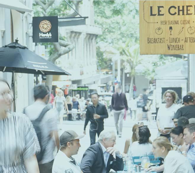
2 The Rise and Rise of the Auckland City Centre For the first time since the 1950 s there are more people commuting to the City Centre by public transport, walking, and cycling than driving WE ARE HERE The resident population (50,000) has doubled over the last ten years. Residents now outnumber the people commuting in by cars Number of jobs in the City Centre is now to 110,000 The estimated total daytime population is 149,000 people There are an estimated 500,000 internal walking trips Business Case for Walking City Centre Transport Trends


3 Public Life The number of pedestrians on Queen Street has doubled since % increase in pedestrians across the City Centre +49% of retail spending since 2010 (now $1.8 billion/year) +41% increase in cafe seats across the City Centre since % increase in public seating places across the City Centre since 2010 PUBLIC LIFE SURVEYS (GHEL, AITKEN TAYLOR)


4 Valuing Urban Realm Toolkit Case study research into applying the TfL VURT methodology in Auckland Measuring Pedestrian Delay Final Report The Relationship between Pedestrian Connectivity and Economic Productivity in Auckland s City Centre March 2017 Technical Report 2017/007 Prepared for: Auckland Design Office, Auckland Council Date: 22 March 2017 Version: Draft Business Case for Walking Research projects
5 Transport Economics OTHER HEALTH BENEFITS ENVIRONMENTAL BENEFITS TRANSPORT RELIABILITY BENEFITS HEALTH BENEFITS (WALKING) WIDER ECONOMIC BENEFITS -Productivity TRANSPORT USER BENEFITS -Travel Time Benefits -Quality Improvements
 Estimating the")


6 Valuing the Urban Realm (VURT) Estimating the user benefits from public realm investment Methodology created and used by Transport for London Objective, evidence-based justifications for investment in public realm Quantifies user benefits Valuing Urban Realm Toolkit Case study research into applying the TfL VURT methodology in Auckland Comparative before & after evaluation Measures & compares changes in public realm quality Link and space values: moving through, lingering, and sitting Business Case for Walking VURT
7 Valuing the Urban Realm (VURT) Uses Pedestrian Environment Review System (PERS) Some factors are more important than others» Future user numbers» Effective footpath width» Personal security» Sense of place» Feeling comfortable Valuing Urban Realm Toolkit User Benefits - Step One Scheme Name Section Number Base Input Data Pedestrians Moving Baseline Scenario Change (S-B) Number (per hour) 0 Average Walk Distance (m) Average Walk Speed (m/s) Static Users Baseline Scenario Change (S-B) Number 0 Average Dwell Time (mins) Time Period of Analysis Weekday Scaling Factor Annualisation Scaling Factor 0 PERS Changes PERS Link Attributes Baseline Scenario Change (S-B) Baseline Value Scenario Value Change (ppm) Effective width Dropped kerbs Obstructions Permeability Business Case for Walking VURT


8 Valuing the Urban Realm (VURT) Karangahape Road Scenario 1A Karangahape Road Scenario 2A A Valuing of the Urban Realm Toolkit for Auckland A Valuing of the Urban Realm Toolkit for Auckland Business Case for Walking VURT

9 Valuing the Urban Realm (VURT) Queen Street Future Transit Mall Business Case for Walking VURT
 NZTA s (2016) Economic Evaluation Manual provides guidance")
10 Measuring Pedestrian Congestion Counting pedestrians in travel time assessment Transport assessment is largely based on the user benefits (or disbenefits) of changes in travel time Delay measurement typically estimates vehicle delay, with monetary values assigned using standard value of users travel time (including for non-work purposes) NZTA s (2016) Economic Evaluation Manual provides guidance on valuing travel time delays incurred by transport users, regardless of mode of travel * MARKETVIEW However, pedestrian delay is rarely measured during cost benefit analysis of a project Business Case for Walking Measuring Pedestrian Congestion


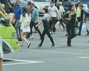
11 Measuring Pedestrian Congestion 13x pedestrians as vehicles on High Street all day 4x pedestrians as vehicles on Queen Street all day Business Case for Walking Measuring Pedestrian Congestion

12 Business Case for Walking Measuring Pedestrian Congestion
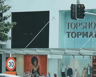
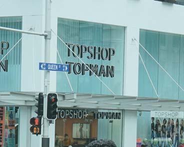
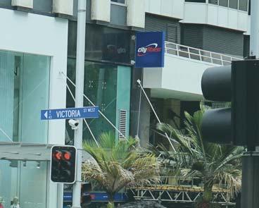
13 Measuring Pedestrian Congestion Over 7,700 pedestrians moved through the intersection in 1 hour 1,200 cars passed through the intersection in same hour Victoria St / Queen St NW Topshop 510 9% Farmers NE Average delay per pedestrian 27 seconds 161,115 hours of annual delay to pedestrians 1,785 31% % % 1,629 29% Annual wasted time due to delay costs $2.2 million NPV is $36 million for free flow conditions* SW ANZ % Starbucks SE *based on a 40 year period with 6% discount rate Business Case for Walking Measuring Pedestrian Congestion
14 Street Name Intersection Type Estimated Cost of Delay/Year 1. Quay Street ~$2M 2. Customs Street 3. Fort Street 3. Shortland Street 4. Wyndham Street 5. Victoria Street 6. Wellesley Street 7. Wakefield Street 8. Mayoral Drive 9. Karangahape Road Barnes Dance, Midblock Crossing, Very High Ped Volumes. Barnes Dance, T-Intersection, Very High Ped Volumes. Barnes Dance, Midblock Crossing, High Ped Volumes. Barnes Dance, T-Intersection Crossing, High Ped Volumes. Barnes Dance, T-Intersection Crossing, High Ped Volumes. Barnes Dance, X-Intersection, High Ped Volumes. Barnes Dance, X-Intersection, High Ped Volumes. Barnes Dance, T-Intersection, Med Ped Volumes. Phased, X-Intersection, Med Ped Volumes. Phased, X-Intersection, Med Ped Volumes. NPV = ~$2M ~$.5M ~$.9M ~$.9M $2.2M ~$2.2M ~$.5M ~$.7M $.7M ~$11.7M ~$186M Wyndham Street Victoria Street Wellesley Street Mayoral Drive K Road Quay Street Customs Street Fort Street Shortland Street Wakefield Street Business Case for Walking Measuring Pedestrian Congestion

15 SOURCES: ECONOMIC GEOGRAPHY, GLOBALISATION AND NEW ZEALAND S PRODUCTIVITY PARADOX (MCCANN, 2009) The evidence suggests that there are major advantages associated with industrial clustering and agglomeration for high knowledgeintensive and high value-added activities, and that the geographical concentration of these types of activities is becoming ever more important. (McCann)


16 Proximity Locating in the centre of things also means it is easier to meet people more often; whether it be a quick catch up coffee, a meeting with a number of people from different organisations, or simply bumping into people on the street it is easier and less time consuming. For most businesses, proximity to amenities for staff - including banks, supermarket, cafes, and services is an important location decision criterion. Cost may not be a critical consideration for those committed to an A-Grade location SOURCES: DRIVERS OF BUSINESS LOCATION IN THE AUCKLAND CBD (GRAVITAS, 2011)


17 Pedestrian Connectivity and Economic Productivity Walking facilitates personal and business networking within business centres. Attractive public spaces and walkable streets create a platform for business and social exchange and support the spread of knowledge. The Relationship between Pedestrian Connectivity and Economic Productivity in Auckland s City Centre March 2017 Technical Report 2017/007 The research suggests that walkability within the Auckland city centre is likely to make a positive contribution to economic productivity. Business Case for Walking Pedestrian Connectivity and Economic Productivity

18 Pedestrian Connectivity and Economic Productivity A pedestrian network was developed based on the existing road network in the study area. Walking network within the study area Pedestrian links were assigned values based on their speed Network analyst software was run to estimate the travel time between each origin and destination point. Business Case for Walking Pedestrian Connectivity and Economic Productivity

19 Pedestrian Connectivity and Economic Productivity Pedestrian travel time matrices were combined with detailed estimates of employment to create a measure of the Effective Job Density (EJD) by walking in all buildings within the study area. Agglomeration economics literature suggests that there is a positive and causal relationship between EJD and productivity. Source: Authors estimates Business Case for Walking Pedestrian Connectivity and Economic Productivity
20 Pedestrian Connectivity and Economic Productivity A proxy measure for labour productivity was estimated based on detailed data on average annual wages from Statistics NZ s Data (2015). Figure 19: The association between walking EJD and labour productivity The point estimate suggests that a 10 per cent increase in walking EJD is associated with a 5.3 per cent increase in productivity. This means that a 1% increase in walking EJD will increase the value of economy of the study area by 0.53% or approximately $42 million based on the authors estimate of $8.01 billion GDP for the study area. Source: Authors estimates Business Case for Walking Pedestrian Connectivity and Economic Productivity\


21 Business Case for Walking Investigating the Economic Value of Walking in the Auckland City Centre
22 Pedestrian Connectivity and Economic Productivity Scenario Testing placeholder
23 Auckland GDP 20% GDP 80% GDP Kilometers SOURCE: RIMU (2017), THE RELATIONSHIP BETWEEN PEDESTRIAN CONNECTIVITY AND ECONOMIC PRODUCTIVITY IN AUCKLAND S CITY CENTRE (BASED ON 2015 DATA)
24 Share of Auckland Region s Employment in City Centre By Industry, 2015 Total Industries Agriculture, Forestry and Fishing Construction Manufacturing Electricity, Gas, Water and Waste... Health Care and Social Assistance Retail Trade Wholesale Trade Other Services Transport, Postal and Warehouse Mining Education and Training Administrative and Support Services Rental, Hiring and Real Estate... Accommodation and Food Services Arts and Recreation Services Public Administration and Safety Professional, Scientific and... Information, Media and... Financial and Insurance Services... 0% 10% 20% 30% 40% 50% 60% 70% Source: Authors estimates based on Infometrics customised (2015) data
25 Growing the City Centre City Centre Masterplan moves to resolve spatial challenges HARBOUR EDGE STITCH THE EAST-WEST STITCH THE ENGINE ROOM CITY RAIL LINK THE GREEN LINK CITY TO THE VILLAGES


26 Staff Attraction: why firms locate in the City Centre For professional services firms that rely heavily on being able to recruit high quality graduates, a CBD location is considered essential to attract staff For most businesses, proximity to amenities for staff - including banks, supermarket, cafes, and services is an important location decision criterion. There is prestige attached to working in the CBD. One of our competitors in the 1980s was located in low rise in [CBD fringe] and it probably set them back for a decade because it just wasn t the place where young professionals wanted to be working... SOURCE: DRIVERS OF BUSINESS LOCATION IN THE AUCKLAND CBD (2011)
The Business Case for Walking. Counting Walking to Make Walking Count in Auckland, New Zealand
 The Business Case for Walking Counting Walking to Make Walking Count in Auckland, New Zealand For the first time since the 1950 s there are more people commuting to the City Centre by public transport,
Measuring Pedestrian Delay
 Measuring Pedestrian Delay Final Report Prepared for: Auckland Design Office, Auckland Council Date: 20 September 2017 Version: Final Document Information Client Auckland Council Job Number NZ2165 Title
Living Streets response to the Draft London Plan
 Living Streets response to the Draft London Plan Contents Living Streets response to the Draft London Plan... 1 About Living Streets... 2 Summary... 2 Consultation response... 3 Chapter 1: Planning London
Extracting Maximum Benefit from Parking Policy - 10 Years Experience in Perth, Australia. By Emmerson Richardson Sinclair Knight Merz
 Extracting Maximum Benefit from Parking Policy - 10 Years Experience in Perth, Australia By Emmerson Richardson Sinclair Knight Merz Snapshot of Perth > Metropolitan Area Population 1.7 million > 3.5 million
DRAFT for a State Policy for Healthy Spaces and Places
 DRAFT for a State Policy for Healthy Spaces and Places 1 DRAFT State Policy for Healthy spaces and Places 1. Purpose To encourage the use and development of land that builds healthy communities through
Wayfinding and Walking in London. Lilli Matson Transport for London May 2013
 Wayfinding and Walking in London Lilli Matson Transport for London May 2013 I want to make walking in London as attractive and enjoyable as possible by making walking count Mayor of London Boris Johnson
Fixed Guideway Transit Outcomes on Rents, Jobs, and People and Housing
 Fixed Guideway Transit Outcomes on Rents, Jobs, and People and Housing Arthur C. Nelson, Ph.D., ASCE, FAICP Professor of Planning and Real Estate Development University of Arizona 1 Changing Transportation
Webinar: The Association Between Light Rail Transit, Streetcars and Bus Rapid Transit on Jobs, People and Rents
 Portland State University PDXScholar TREC Webinar Series Transportation Research and Education Center (TREC) 11-15-2016 Webinar: The Association Between Light Rail Transit, Streetcars and Bus Rapid Transit
Speed Limits in the Hoddle Grid
 Speed Limits in the Hoddle Grid Recent History of speed limits March 2013 Docs # 7738485 1 Introduction Muncipalities have power to Erect speed limit signs BUT Municipalities DO NOT have the power to approve
TRANSPORTATION TOMORROW SURVEY
 Clause No. 15 in Report No. 7 of was adopted, without amendment, by the Council of The Regional Municipality of York at its meeting held on April 17, 2014. 15 2011 TRANSPORTATION TOMORROW SURVEY recommends
complete streets design and construction standards public primer City of Edmonton
 complete streets design and construction standards public primer City of Edmonton introduction Complete Streets are streets for everyone: people who walk, wheel, bike, take transit, or drive. They are
IAN WHITE ASSOCIATES. Crawley Station Gateway Public Realm
 IAN WHITE ASSOCIATES Crawley Station Gateway Public Realm contents 1. objectives & client brief 2. site appraisal 3. best practice guidance 4. design concept 1. objectives & client brief Crawley Train
Community engagement guide May 2018
 Community engagement guide May 2018 Greater Wellington Regional Council (GWRC), Hutt City Council (HCC) and the New Zealand Transport Agency (NZTA) are working together to achieve some big improvements
Bikeway action plan. Bicycle Friendly Community Workshop March 5, 2007 Rochester, MN
 Bikeway action plan Summary The was held on March 5, 2007 at the Rochester Mayo Civic Center. The workshop was hosted by Rochester-Olmsted County Planning Department in collaboration with the League of
EXECUTIVE SUMMARY: TRANSIT-ORIENTED DEVELOPMENT IN SMITHS FALLS, ONTARIO; A COMPARISON BETWEEN TWO SITES
 EECUTIVE SUMMARY: TRANSIT-ORIENTED DEVELOPMENT IN SMITHS FALLS, ONTARIO; A COMPARISON BETWEEN TWO SITES Topic and Purpose In 2007, the Mayor of Ottawa s Task Force on Transportation suggested adding a
Launceston's Transport Futures. Greater travel options for the people of Launceston
 Launceston's Transport Futures Greater travel options for the people of Launceston Final Draft 13 Jan 2014 1 Page Number Executive summary 3 What is Transport Futures? 4 Vision 6 Economy, access and liveability
A future cycle route network for North Staffordshire mb/08/16 Need for a strategy. Existing cycle route network
 Need for a strategy 1. The government s aim is to double cycling levels nationally by 2025 [note 1]. This would bring significant health, environmental, economic and traffic benefits [note 2]. It is widely
Vision - Britain's Ocean City One of Europe's most vibrant waterfront cities where an outstanding quality of life is enjoyed by everyone
 PLYMOUTH Economy Nina Sarlaka, Enterprise & Inward Investment Manager Vision - Britain's Ocean City One of Europe's most vibrant waterfront cities where an outstanding quality of life is enjoyed by everyone
Kevin Manaugh Department of Geography McGill School of Environment
 Kevin Manaugh Department of Geography McGill School of Environment Outline Why do people use active modes? Physical (Built environment) Factors Psychological Factors Empirical Work Neighbourhood Walkability
Labour Market Segmentation in Poland. Artur Gajdos Department of Spatial Econometrics University of Lodz
 Labour Market Segmentation in Poland Artur Gajdos Department of Spatial Econometrics University of Lodz gajdos@uni.lodz.pl Lisbon, 24 November 2016 Agenda Introduction Labour market facts Policy reforms
Regional Cycle Programme Update
 Agenda Item 10 (ii) Regional Cycle Programme Update Glossary Auckland Council Auckland Transport Cycle Action Auckland New Zealand Transport Agency Regional Cycle Network (AC) (AT) (CAA) (NZTA) (RCN) Executive
TRANSPORTATION NEEDS ASSESSMENT
 TRANSPORTATION NEEDS ASSESSMENT A travel demand analysis was carried out to determine the operational issues and the potential benefit that adding traffic capacity would have on the road network. All the
City of Perth Cycle Plan 2029
 Bicycling Western Australia s response City of Perth Cycle Plan 2029 2012-2021 More People Cycling More Often ABOUT BICYCLING WESTERN AUSTRALIA Bicycling Western Australia is a community based, not-for-profit
Investment in Active Transport Survey
 Investment in Active Transport Survey KEY FINDINGS 3 METHODOLOGY 7 CYCLING INFRASTRUCTURE 8 Riding a bike 9 Reasons for riding a bike 9 Mainly ride on 10 Comfortable riding on 10 Rating of cycling infrastructure
Public Consultation Centre For. Transportation Master Plan Update. Information Package
 Public Consultation Centre For Transportation Master Plan Update Information Package Date Location Hours Tuesday, September 12, 2017 Wednesday, September 13, 2017 Tuesday, September 19, 2017 Cambridge
The Amsterdam Story. The socio-economic value of cycling and innovative planning practices in context in transition. Kees van Ommeren.
 The Amsterdam Story The socio-economic value of cycling and innovative planning practices in context in transition Kees van Ommeren Paolo Ruffino Questions answered in this presentation What are the economic
Update June 2018 OUR 2017 PUBLIC ENGAGEMENT
 Update June 2018 Hi, Let s Get Wellington Moving (LGWM) is developing a Recommended Programme of Investment (RPI) that meets our programme objectives and supports the city s and region s growth. As part
Economic Impact of the Recreational Marine Industry Broward, Miami-Dade, and Palm Beach Counties, Florida
 Economic Impact of the Recreational Marine Industry Broward, Miami-Dade, and Palm Beach Counties, Florida - 2018 Completed by THOMAS J. MURRAY & ASSOCIATES, INC. For MARINE INDUSTRIES ASSOCIATION OF SOUTH
AUCKLAND INNOVATION THE CITY EAST WEST TRANSPORT STUDY ABSTRACT
 CEWT Study D Newcombe Page 0 AUCKLAND INNOVATION THE CITY EAST WEST TRANSPORT STUDY Author/Presenter: Daniel Newcombe, MEngSt (Transportation), BPlan, MNZPI Corridor & Centre Plans leader, Auckland Transport
Rochester Downtown Bicycle Study 2009
 Rochester Downtown Bicycle Study 2009 Relationship of ROCOG Long Range Transportation Plan to Rochester Comprehensive Plan Regional Long Range Transportation Plan (LRTP) is prepared under the auspices
Active Travel Strategy Dumfries and Galloway
 Active Travel Strategy Dumfries and Galloway Our Active Travel Strategy The agreed Interventions for Dumfries and Galloway Council s Local Transport Strategy includes an action to Develop an Active Travel
Frequently asked questions about how the Transport Walkability Index was calculated are answered below.
 Transport Walkability Index The Transport Walkability Index is a relative indicator of how well the built environment in different areas supports walking for transport. The index is frequently used in
Mumford Terminal Replacement Opportunities Neighbourhood Open House. we are here. PHASE 2 Identifying and Evaluating Candidate Sites
 Welcome Replacement Opportunities Neighbourhood Open House. AGENDA PURPOSE 1. REVIEW the information boards 2. DISCUSS aspects of the project with the project team 3. SHARE your thoughts on replacement
GLEN EIRA CITY COUNCIL. MURRUMBEENA Transforming our neighbourhood together our concepts based on your ideas
 GLEN EIRA CITY COUNCIL MURRUMBEENA Transforming our neighbourhood together our concepts based on your ideas 1 WHAT HAVE WE HEARD? WHAT NOW? Stage one Tell us what you love about your shopping strip November
The best indicator of an individual s and expanding access to parks and open space.
 Health & Wellness Create a Safe and Healthy Built Environment Artist s rendering, 2014 Health is important to Loveland residents, and stakeholders see the many strong connections between quality of life,
Transit boulevard: A new road type for Sydney s Growth Centres
 Transit boulevard: A new road type for Sydney s Growth Centres Cleaver, M. A., de Roos, M. P., NSW Centre for Road Safety, Roads and Traffic Authority, NSW Collins, G., Network Services, Roads and Traffic
1. UK policy context
 1. UK policy context 2. Political leadership The Mayor s Vision My vision to create Healthy Streets aims to reduce traffic, pollution and noise, create more attractive, accessible and people-friendly streets
Appendix A-K Public Information Centre 2 Materials
 Appendix A-K Public Information Centre 2 Materials Our Rapid Transit Initiative Make an impact on the future of transit Join the discussion on Rapid Transit in London You re invited to a Public Information
ATTACHMENT 4 - TDM Checklist. TDM Checklist Overview
 ATTACHMENT 4 - TDM Checklist TDM Checklist Overview The proposed checklist rates developments on the degree to which they are TDM and transit supportive. Points are assigned based on the level of transit
Measuring Transportation: Traffic, Mobility and Accessibility
 Measuring Transportation: Traffic, Mobility and Accessibility THIS FEATURE COMPARES THREE APPROACHES TO MEASURING TRANSPORTATION SYSTEM PERFORMANCE. TRAFFIC-BASED MEASUREMENTS EVALUATE MOTOR VEHICLE MOVEMENT;
2011 Census Snapshot: Method of Travel to work in London
 CIS 2014-06 2011 Census Snapshot: Method of Travel to work in London March 2014 Introduction On 26 th of March 2014, the Office for National Statistics (ONS) published a series of tables looking at the
AMETI PANMURE: A SUSTAINABLE TRANSPORT SOLUTION - OR NOT? Phil Harrison, Opus International Consultants
 IPWEA Conference: 7 June 11 June 2015 Abstract AMETI PANMURE: A SUSTAINABLE TRANSPORT SOLUTION - OR NOT? Phil Harrison, Opus International Consultants The AMETI project is a package of multi-modal transport
Birmingham Connected. Edmund Salt. Transportation Policy Birmingham City Council
 Birmingham Connected Edmund Salt Transportation Policy Birmingham City Council www.birmingham.gov.uk/connected Birmingham Connected the story so far Broadly following EU Guidance We ve done all of this
Contents Location Map Welcome and Introduction Travel Plan Management Science Park Accessibility Walking Cycling Bus Rail Car Sharing Contact Details
 Contents Contents Location Map Welcome and Introduction Travel Plan Management Science Park Accessibility Walking Cycling Bus Rail Car Sharing Contact Details 1 2 3 5 7 9 11 13 15 17 19 Thames Valley Science
A CHANGING CITY. of Edmonton, it is essential that it reflects the long-term vision of the City.
 A CHANGING CITY By the year 2040, Edmonton will be home to more than 1 million people. To accommodate growth and support a healthy and compact city, we need a new approach to development/redevelopment
City of Davenport CitiBus Public Transportation Study. April 2015
 City of Davenport CitiBus Public Transportation Study April 2015 Overview Project Background Key Findings CitiBus Service Allocation Policy Discussion 2 Project Background 3 About CitiBus Operates 17 routes
WELCOME TO OPEN HOUSE # 1 June 14, 2017
 Langstaff Road Weston Road to Highway 7 Class Environmental Assessment Study WELCOME TO OPEN HOUSE # 1 June 14, 2017 Please sign in and join our mailing list Purpose of Open House #1 & Study Area York
2. Context. Existing framework. The context. The challenge. Transport Strategy
 Transport Strategy Providing quality connections Contents 1. Introduction 2. Context 3. Long-term direction 4. Three-year priorities 5. Strategy tree Wellington City Council July 2006 1. Introduction Wellington
Creating walkable, bikeable and transit-supportive communities in Halton
 Creating walkable, bikeable and transit-supportive communities in Halton By presenting current research and best practices, the information in this paper is meant to support and broaden discussion on how
NOTES FROM JUNIOR COUNCIL ORIENTATION SESSION HELD ON MONDAY, JANUARY 22, 2018, AT 3:30 PM IN COUNCIL CHAMBERS, CITY HALL
 CITY OF KAMLOOPS Junior Council Meeting Agenda March 12, 2018, at 3:30 pm in Council Chambers, 7 Victoria Street West, Kamloops, BC Page 1. APPROVAL OF THE AGENDA 2. MINUTES Attachment Recommendation:
Nevada County Population Projections 2015 to 2034
 Nevada County Population Projections 2015 to 2034 Prepared By: Jeff Hardcastle, AICP Nevada State Demographer Nevada Department of Taxation Reno Office: 4600 Kietzke Lane, Building L Suite 235 Reno, NV
June 2015 REGIONAL TRANSPORTATION SNAPSHOT
 June 2015 REGIONAL TRANSPORTATION SNAPSHOT THE REGION Who are we? The Greater Toronto and Hamilton Area (GTHA), consisting of Durham Region, Halton Region, the City of Hamilton, Peel Region, the City of
DESIGN CODE. Enterprise West Harlow London Road North Design Code 21
 DESIGN CODE Enterprise West Essex @ Harlow London Road North Design Code 21 4 MAXIMUM BUILDING HEIGHTS 4.1 Table 4A sets out maximum building height standards for each character area within the LDO boundary.
Big Changes, Unknown Impacts
 Big Changes, Unknown Impacts Boulder Economic Forecast Place cover image here Richard Wobbekind Senior Economist and Associate Dean for Business and Government Relations January 17, 2018 Real GDP Growth
High frequency bus services operating to Little Island; Creation of a new Park and Ride site and train station at North Esk;
 Cork County Council 7 th December 2018 Dear Adrian O Neill (aoneill@jbbarry.ie) The Transport and Mobility Forum, Cork (TMF) is a representative group of organisations who have a common interest in sustainable
By making use of SAFRIM (South African Inter-Industry Macro-Economic Model) By Jeaunes Viljoen, Conningarth Economists, 1
 By Jeaunes Viljoen, Conningarth Economists, 1") By making use of SAFRIM (South African Inter-Industry Macro-Economic Model) By Jeaunes Viljoen, Conningarth Economists, South Africa 10/13/2011 1 1960: The economy experienced high growth rates mining
By making use of SAFRIM (South African Inter-Industry Macro-Economic Model) By Jeaunes Viljoen, Conningarth Economists, South Africa 10/13/2011 1 1960: The economy experienced high growth rates mining
The 2010 Economic Contribution of Tourism to the Meadowlands Liberty Region
 The 2010 Economic Contribution of Tourism to the Meadowlands Liberty Region Key Metrics & Evaluation 93 MAIN STREET :: ANNAPOLIS, MD 21401 WWW.VANTAGESTRATEGY.COM :: 202-449- 9708 1 Vantage Strategy ::.
MEETING Agenda. Introductions. Project Overview. Key Study Components. Alternative Station Concepts. Preferred Station Concept. Next Steps.
 City GARLAND Council ROADVISION Briefing STUDY VISION STUDY Dallas, TX April 8, 2010 1 1 MEETING Agenda Introductions Project Overview Key Study Components Alternative Station Concepts Preferred Station
162 RESIDENTS ATTENDED 2 DAYS OF WORKSHOPS 15 TABLE DISCUSSIONS WHAT WE HEARD. Oakridge Municipal Town Centre Workshops PLANNING PROGRAM
 OAKRIDGE MTC WORKSHOP 2017 CAMBIE CORRIDOR Phase 3 STEP 3: 3: October June 2017 CAMBIE CORRIDOR PLANNING PROGRAM 2 DAYS OF WORKSHOPS 15 TABLE DISCUSSIONS 162 RESIDENTS ATTENDED WHAT WE HEARD Oakridge Municipal
Connecting Sacramento: A Trip-Making and Accessibility Study
 Connecting Sacramento: A Trip-Making and Accessibility Study Study Overview and Highlights July 2017 Purpose of this study Local governments and transportation agencies often make challenging decisions
2010 Pedestrian and Bicyclist Special Districts Study Update
 2010 Pedestrian and Bicyclist Special Districts Study Update Pedestrian and Bicyclist Special Districts Program Overview H-GAC s Special Districts Program aims to provide strategic investments in pedestrian
Seal Extension Guidelines. Asset Management and Systems
 Seal Extension Guidelines 1. Guideline Definitions AADT - Annual Average Daily Traffic is measured at regular annual (or greater) intervals and adjusted for seasonal effects, using an approved traffic
21.07 TRANSPORT CONNECTIVITY AND INFRASTRUCTURE
 21.07 TRANSPORT CONNECTIVITY AND INFRASTRUCTURE 21.07-1 Connectivity and Choice Transport connectivity and mode choice are critical to achieving productive, sustainable and socially just cities. Travel
Complete Streets 101: The Basics
 Complete Streets 101: The Basics Michigan Municipal League - Capital Conference March 21, 2017 Chip Smith, AICP - Senior Planner - Wade Trim Inc. and City Council member City of Ann Arbor 2017 MML Capital
2018 Transportation Survey October 17, Prepared by:
 Transportation Survey October 17, Prepared by: Overview Methodology Systemwide results Strengths/Weaknesses by mode Importance of possible improvements Conclusions Methodology 500 Chittenden County residents
Arlington County 10-Year Transit Development Plan & Premium Transit Network Briefing. May 2016
 Arlington County 10-Year Transit Development Plan & Premium Transit Network Briefing May 2016 Overview 10-Year Transit Development Plan Premium Transit Network Columbia Pike service concept Premium amenities
EMBARGOED UNTIL 00:01 THURSDAY 9 AUGUST 2007 RESEARCH NOTE 17 HIDDEN COSTS OF 2012: CONSTRUCTION INFLATION TO COST 4 BILLION
 EMBARGOED UNTIL 00:01 THURSDAY 9 AUGUST 2007 www.taxpayersalliance.com/2012 RESEARCH NOTE 17 HIDDEN COSTS OF 2012: CONSTRUCTION INFLATION TO COST 4 BILLION This research note shows how the 2012 Olympics
NEWMARKET UPHAM S CORNER
 SOUTH STATION Planning Initiative NEWMARKET UPHAM S CORNER COLUMBIA ROAD (P) FOUR CORNERS/GENEVA Working Advisory Group (WAG) Meeting #5 TALBOT AVENUE MORTON STREET BLUE HILL AVE/CUMMINS HWY (P) RIVER
New Directions in Street Auditing: Lessons from the PERS Audits. David Allen, Transport Research Laboratory. Spencer Clark, Transport for London
 New Directions in Street Auditing: Lessons from the PERS Audits David Allen, Transport Research Laboratory Spencer Clark, Transport for London TRL (Transport Research Laboratory) and TfL, Transport for
City Centres. Chris Vallyon, Shane Turner, Shane Binder
 Improving Pedestrian Amenity in City Centres Chris Vallyon, Shane Turner, Shane Binder chris.vallyon@beca.com CBD Environments CBD Planning "As things stood now a downtown shopper needed a four-leaf clover
Bicycle and Pedestrian Connectivity Study. Old Colony Planning Council
 Bicycle and Pedestrian Connectivity Study Old Colony Planning Council Outline Why consider bike/peds in road designs? Why are measures needed? Connecting Land Use with Transportation Evaluation Tools:
Cities Connect. Cities Connect! How Urbanity Supports Social Inclusion
 Cities Connect! How Urbanity Supports Social Inclusion Todd Litman Victoria Transport Policy Institute Metropolis Toronto, Canada - 14 June 2006 Cities Connect People with people. People with jobs. People
 Time of Change We Are Growing We Are An Attractive Place To Live We Are Age Diverse + Living Longer 50000 40000 30000 20000 10000 0 2010 Census Job Density Housing Sheds Transit Sheds The Project FUNDING
Planning Daily Work Trip under Congested Abuja Keffi Road Corridor
 ISBN 978-93-84468-19-4 Proceedings of International Conference on Transportation and Civil Engineering (ICTCE'15) London, March 21-22, 2015, pp. 43-47 Planning Daily Work Trip under Congested Abuja Keffi
AUTOMATED AND ZERO EMISSION VEHICLES HOW THEY MIGHT RESHAPE OUR STREETS
 AUTOMATED AND ZERO EMISSION VEHICLES HOW THEY MIGHT RESHAPE OUR STREETS STURT ST BALLARAT WATERGARDENS TAYLORS LAKES SIMPSON ST YARRAVILLE CHAPEL ST SOUTH YARRA RINGWOOD STATION MONASH FREEWAY SA NSW VIC
Project Launch Community Meeting 1 Summary
 ConsumersNext: Planning for People and Business at Sheppard and Victoria Park Project Launch Community Meeting 1 Summary Participants Listening to the Overview Presentation Prepared for the City of Toronto
Douglas Land Use and Transportation Strategy (DLUTS) Summary. August 2013
 Summary. August 2013") Douglas Land Use and Transportation Strategy (DLUTS) Summary August 2013 Background Douglas is a large and popular residential suburb of approximately 30,000 persons on the periphery of Cork City along
Douglas Land Use and Transportation Strategy (DLUTS) Summary August 2013 Background Douglas is a large and popular residential suburb of approximately 30,000 persons on the periphery of Cork City along
Exhibit 1 PLANNING COMMISSION AGENDA ITEM
 Exhibit 1 PLANNING COMMISSION AGENDA ITEM Project Name: Grand Junction Circulation Plan Grand Junction Complete Streets Policy Applicant: City of Grand Junction Representative: David Thornton Address:
Multimodal Transportation Plan
 Multimodal Transportation Plan The Multimodal Transportation Plan will accommodate MILLENIALS ARE DRIVING LESS. WE CANNOT BUILD OUR WAY all modes of transportation by keeping pedestrians, OUT OF CONGESTION.
METHODOLOGY. Signalized Intersection Average Control Delay (sec/veh)
") Chapter 5 Traffic Analysis 5.1 SUMMARY US /West 6 th Street assumes a unique role in the Lawrence Douglas County transportation system. This principal arterial street currently conveys commuter traffic
Chapter 5 Traffic Analysis 5.1 SUMMARY US /West 6 th Street assumes a unique role in the Lawrence Douglas County transportation system. This principal arterial street currently conveys commuter traffic
SCARBOROUGH CENTRE TRANSPORTATION MASTER PLAN (SCTMP)
") SCARBOROUGH CENTRE TRANSPORTATION MASTER PLAN (SCTMP) Public Consultation Meeting #2 May 10 th, 2017 Presentation Outline 1 Project Schedule and Background 2 Draft Evaluation of Alternatives 3 Preliminary
SCARBOROUGH CENTRE TRANSPORTATION MASTER PLAN (SCTMP) Public Consultation Meeting #2 May 10 th, 2017 Presentation Outline 1 Project Schedule and Background 2 Draft Evaluation of Alternatives 3 Preliminary
4.1 Introduction. 4.2 Aspects of walkable communities
 4 Community walkability Community walkability Making communities walkable Urban form Feeling secure 4.1 Introduction Walkability describes the extent to which the built environment is walking-friendly.
PEDESTRIAN ACTION PLAN
 ATTACHMENT 2 CITY OF SANTA MONICA PEDESTRIAN ACTION PLAN CITY OF SANTA MONICA PEDESTRIAN ACTION PLAN This page intentionally left blank EXECUTIVE SUMMARY CHAPTER 1 EXECUTIVE SUMMARY Setting the Stage
San Mateo County Comprehensive Bicycle and Pedestrian Plan Open House
 San Mateo County Comprehensive Bicycle and Pedestrian Plan Open House October 28, 2010 Presented to San Mateo County residents and interested parties by Lauren Ledbetter, Alta Planning + Design Matt Haynes,
CITY OF ABBOTSFORD TRANSPORTATION AND TRANSIT MASTER PLAN
 CITY OF ABBOTSFORD TRANSPORTATION AND TRANSIT MASTER PLAN EXECUTIVE COMMITTEE MONDAY, OCTOBER 2, 2017 TRANSPORTATION & TRANSIT AGENDA 1. Plan Overview 2. Shaping Influences 3. Existing Conditions and What
Making Dublin More Accessible: The dublinbikes Scheme. Martin Rogers Colm Keenan 13th November 2012
 : The dublinbikes Scheme Martin Rogers Colm Keenan 13th November 2012 Modal Splits for Dublin 2001-2011 Dublin Mode Share Summary - Persons Crossing Canal Cordon 07.00-10.00 Year Total All PT % Car % Walk
Developing a Birmingham Transport Space Allocation policy. David Harris Transport Policy Manager Economy Directorate Birmingham City Council
 Developing a Birmingham Transport Space Allocation policy David Harris Transport Policy Manager Economy Directorate Birmingham City Council Birmingham s Sustainable Urban Mobility Plan Birmingham Connected
Bridgewater Complete Streets Prioritization Plan and Pedestrian Safety Assessment
 Bridgewater Complete Streets Prioritization Plan and Pedestrian Safety Assessment Presented by Luciano Rabito Manager of Complete Streets Presented to Bridgewater, MA Wednesday, April 26, 2017 6:30 P.M.
Dear City Council Members,
 From: Bob Kenyon [mailto: ] Sent: Monday, February 08, 2016 10:20 AM To: City Clerk Subject: Please prioritize Caltrain and a complete transit network Thank you for prioritizing bringing BART to San Jose
Urban Transport Policy-making changing perspectives and consequences
 Urban Transport Policy-making changing perspectives and consequences Peter Jones, UCL ITLS, University of Sydney, 28 th March 2018 Overview Changing urban transport policy perspectives From car-based to
HAMILTON BIKING PLAN OUR VISION: A BIKE FRIENDLY CITY
 HAMILTON BIKING PLAN 2015-2045 OUR VISION: A BIKE FRIENDLY CITY INTRODUCTION Biking as a travel option is experiencing a resurgence internationally and in New Zealand, growing as a familyfriendly and healthy
NACTO Designing Cities Conference Project Evaluation: Tools for Measuring Success and Building Support. October 29, 2015
 NACTO Designing Cities Conference Project Evaluation: Tools for Measuring Success and Building Support October 29, 2015 The case for evaluation: Have a social contract with City Council, staff and community
Note this page is intentionally left blank for page layout purposes
 Note this page is intentionally left blank for page layout purposes Contents 1 Purpose of the Master Plan... 1 2 Development of the Master Plan... 1 3 How the Master Plan fits with other strategic plans
Regional Cycling Plan
 Adopted December 2008 Quality for Life Adopted December 2008 For more information, contact: Greater Wellington 142 Wakefield Street PO Box 11646 Manners Street Wellington 6142 T 04 384 5708 F 04 385 6960
The proposed development is located within 800m of an existing Transit Station where infill developments and intensification are encouraged.
 Stantec Consulting Ltd. 1331 Clyde Avenue, Suite 4 Ottawa ON K2C 3G4 Tel: (613) 722-442 Fax: (613) 722-2799 May 14, 213 File: 1638823 Robinson Park Development Corp. 5699 Power Road Ottawa, ON, K1G 3N4
Response to further information request Ministry of Education Notice of Requirement (200 & 252 Park Estate Road)
") 21 Pitt Street PO Box 6345, Auckland 1141, New Zealand T: +64 9 300 9000 // F: +64 9 300 9300 E: info@beca.com // www.beca.com Auckland Council Private Bag 92300 Victoria Street West Auckland 1142 15 August
21 Pitt Street PO Box 6345, Auckland 1141, New Zealand T: +64 9 300 9000 // F: +64 9 300 9300 E: info@beca.com // www.beca.com Auckland Council Private Bag 92300 Victoria Street West Auckland 1142 15 August
HENDERSON DEVELOPMENT 213, 217, 221, 221 ½, 223 HENDERSON AVENUE and 65 TEMPLETON STREET OTTAWA, ONTARIO TRANSPORTATION OVERVIEW.
 HENDERSON DEVELOPMENT 213, 217, 221, 221 ½, 223 HENDERSON AVENUE and 65 TEMPLETON STREET OTTAWA, ONTARIO TRANSPORTATION OVERVIEW Prepared for: 2294170 Ontario Inc. February 2, 2017 117-652 Report_1.doc
STUDY ADVISORY COMMITTEE. October 8, 2015
 STUDY ADVISORY COMMITTEE October 8, 2015 Study Purpose evaluate the long-term transportation strategies and investments needed to sustain the county s economic health and quality of life in the coming
Pattullo Bridge Replacement Project Community Connections Phase 2 Consultation. Appendix 3: Open House Display Boards
 Replacement Project Community Connections Phase 2 Consultation Appendix 3: Open House Display Boards November 2016 Welcome! Welcome to the Replacement Project Public Open House We Want to Hear from You
Cycling Economies. Economic Impacts of Bike Lanes. Daniel Arancibia
 Cycling Economies Economic Impacts of Bike Lanes Daniel Arancibia Introduction Research is showing that cyclists are good customers, that their numbers and economic impact increase with bike lanes, and