Uptown West Neighbourhood Transportation Study
|
|
|
- Alexander Chapman
- 6 years ago
- Views:
Transcription

1 Uptown West Neighbourhood Transportation Study Public Open House #2 Information for Review As we move towards the second public open house on May 6, 2014, information on the alternative solutions that will be presented is provided for the community to review in advance of the open house. Alternative Network Scenarios Four network scenarios are being presented at the public meeting on May 6. The scenarios have been developed using technical data and includes feedback from the public task force, the October 30 Public Engagement Session, various technical agencies and City staff. The scenarios attempt to address the issues and concerns raised through the study while recognizing the needs of emergency response providers, city services such as snow plow operations, garbage and recycling collection, and maintenance works. The three alternative scenarios, in addition to the business as usual scenario, have been developed to address the main transportation issues identified by neighbourhood residents. Graphical representations of these alternative scenarios and the various measures at strategic locations within the neighbourhood are attached. In each of the alternative scenarios, routes through the neighbourhood are still possible (but less direct in most cases) in order to accommodate residents, businesses, school bus routes on Roslin Avenue, and patrons to community destinations within the neighbourhood. The introduction of less direct routes and measures to slow the movement of vehicles through the neighbourhood are anticipated to discourage future traffic infiltration onto neighbourhood streets. During the development of the alternative scenarios, we have heard feedback from multiple perspectives. We have heard that the scenarios developed will address the issues and objectives of the study. We have heard that the scenarios do not go far enough in protecting the neighbourhood. We have heard that the scenarios go too far and disrupt the ability of residents to travel easily in and out of their own neighbourhood. We have heard that there will be costs associated with constructing and maintaining the traffic calming measures, as well as ongoing cost impacts to City and Regional operations (snow plowing, garbage and recycling collection, emergency response). The study seeks to reach a balanced solution that recognizes all of the above. Waterloo Service Centre 265 Lexington Court, Waterloo, Ont. N2J 4A8 P F TTY The City of Waterloo is committed to providing accessible formats and communication supports for persons with disabilities. If another format would work better for you, please contact: , communications@waterloo.ca or TTY at
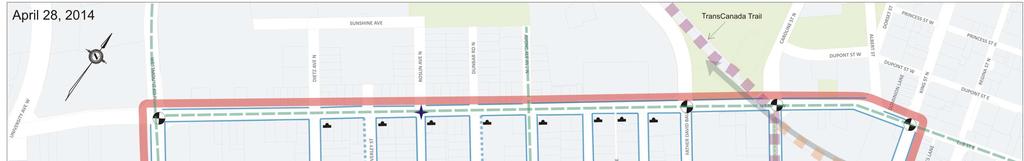
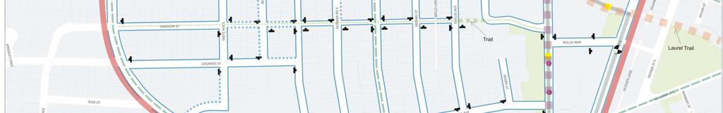
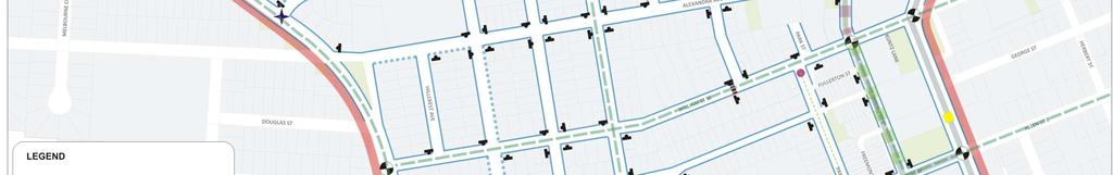
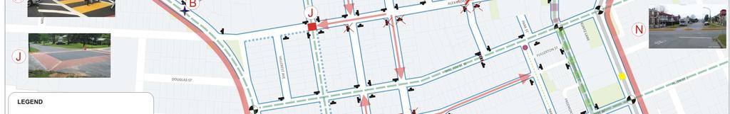
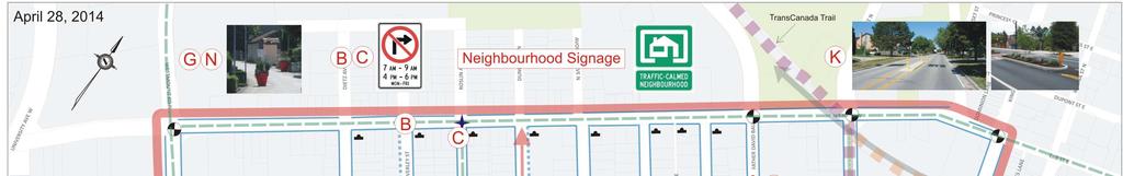
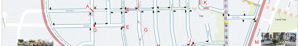
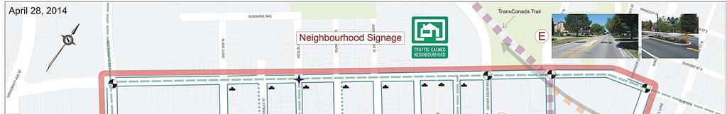
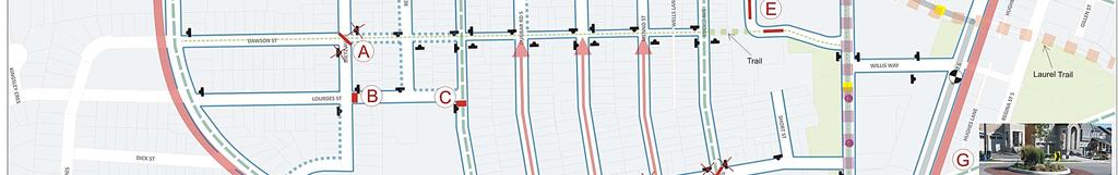
2 Uptown West Neighbourhood Transportation Study For your consideration, the traffic calming measures for each of the alternative scenarios are described below and are illustrated on the accompanying maps. Each scenario has advantages and disadvantages. After your review of the information presented, we invite you to complete a brief online survey ( regarding your preferences on the alternative scenarios. Scenario 1 In this business as usual scenario, no new traffic calming features will be implemented within Uptown West. However, through other programs and initiatives, several changes to the transportation network are anticipated. The Region s LRT project will introduce LRT on Caroline Street between Erb Street and Allen Street. The City s Transportation Master Plan identified future bike routes on Avondale Avenue, William Street and Allen Street, as well as Westmount Road, Erb Street, Park Street (south of Allen Street) and Caroline Street (between William Street and Allen Street). The City also has a sidewalk program that looks to provide sidewalks where there are missing connections based on city wide priorities. Scenario 2 This scenario endeavours to calm traffic and discourage infiltration in the following manner: From Westmount Road to Erb Street: Right turn restrictions on Westmount Road during the peak period at the intersections of Dawson Street, Dietz Avenue and Norman Street From Erb Street: Right turn restrictions on Erb Street during the peak period at Dietz Avenue, Beverly Street, Dunbar Road, and Avondale Avenue Raised crosswalk and raised intersection on Roslin Avenue Diverter at Euclid Avenue/Alexandra Avenue Raised median islands or speed cushions on Father David Bauer Drive North south through traffic: Raised crosswalk and raised intersection on Roslin Avenue; road closure at Roslin Avenue/Allen Street/John Street One way segments on Dunbar Road and Avondale Road East west through traffic Diverter, one way segment and raised intersection on Alexandra Avenue One way segments on Norman Street; right turn restriction on Westmount Road at Norman Street Intersection median on Park Street at Allen Street; road closure at Roslin Avenue/Allen Street/John Street Diverter on John Street at Belmont Avenue Scenario 3 This scenario endeavours to calm traffic and discourage infiltration in the following manner: From Westmount Road to Erb Street: Diverter at Dawson Street at Dietz Avenue Right turn restrictions during the peak period from Beverly Street on to Erb Street and from Roslin Avenue on to Erb Street Raised crosswalk on Lourdes Street at Dietz Avenue April 28, 2014
3 Uptown West Neighbourhood Transportation Study From Erb Street: Raised crosswalk and raised intersection on Roslin Avenue One way segment on Dunbar Road Diverters at Euclid Avenue/Alexandra Avenue and at Avondale Avenue/Alexandra Avenue Raised median islands or speed cushions on Father David Bauer Drive North south through traffic: Raised crosswalk and raised intersection on Roslin Avenue; road closure at Roslin Avenue/Allen Street/John Street One way segments and traffic calming pinch points on Dunbar Road Diverter at Avondale Avenue/Alexandra Avenue; traffic circle at Avondale Avenue / William Street East west through traffic Diverter on Dawson Street at Dietz Avenue Raised crosswalk on Lourdes Street at Dietz Avenue Diverters and raised intersection on Alexandra Avenue Traffic circle on William Street at Avondale Avenue One way segments and traffic calming pinch points on Norman Street Intersection median on Park Street at Allen Street; road closure at Roslin Avenue/Allen Street/John Street Diverter on John Street at Belmont Avenue Scenario 4 This scenario endeavours to calm traffic and discourage infiltration in the following manner: From Westmount Road to Erb Street: Diverter on Dawson Street at Dietz Avenue Raised crosswalk on Lourdes Street at Dietz Avenue From Erb Street: Raised crosswalk on Roslin Avenue One way segments on Dunbar Road, Avondale Avenue and Menno Street Diverter on Euclid Avenue at Alexandra Avenue Raised median islands or speed cushions on Father David Bauer Drive North south through traffic: Raised crosswalk and one way segment on Roslin Avenue; half closure on Roslin Avenue at John Street One way segments on Dunbar Road One way segment, traffic circle and diverter on Avondale Avenue East west through traffic Diverter on Dawson Street at Dietz Avenue Raised crosswalk on Lourdes Street at Dietz Avenue Diverter on Alexandra Avenue at Euclid Avenue Traffic circle on William Street at Avondale Avenue Diverter on Norman Street at Avondale Avenue Intersection median on Park Street at Allen Street; half road closure on Allen Street at John Street Diverter on John Street at Belmont Avenue April 28, 2014
4 Uptown West Neighbourhood Transportation Study Next Steps At the public meeting, a short presentation for each of the alternative networks will be available (presentations will be shown continuously over the course of the evening) as well as display boards that will provide the project background, study process and next steps. Members of the study team will also be available to answer any questions you may have. Details of the Public Open House are as follows: Date: Tuesday, May 6, 2014 Time: 6:00 PM to 8:00 PM (drop in format) Location: Knox Presbyterian Church, 50 Erb Street W, Waterloo If you require any additional information, please visit our study website at or contact either of the study team members listed below: Chris Hodgson, P.Eng. Senior Project Engineer Engineering Services Integrated Planning & Public Works, City of Waterloo 265 Lexington Court, PO Box 337 Station Waterloo Waterloo, ON N2J 4A Ext Christopher.Hodgson@waterloo.ca Suzette Shiu, P.Eng. Consultant Project Manager Cole Engineering Group Ltd. 70 Valleywood Drive Markham, ON L3R 4T Ext. 436 UptownWest@ColeEngineering.ca April 28, 2014
5
6 Scenario 1 Description of Measures ID Description Example Measure: Sidewalk Location: Various locations in the neighbourhood where sidewalks are currently missing Rationale: Enhance safety of pedestrians and encourage active transportation by providing designated space for pedestrians separate from vehicular travel Sidewalks to be implemented in accordance with a City wide sidewalk program that looks to address missing connections throughout the City. The program once developed will seek to prioritize locations on a City wide basis. Measure: Signed on road bike routes Location: Avondale Avenue; William Street; Allen Street; Westmount Road; Erb Street; Park Street (south of Allen Street); Caroline Street (between William Street and Allen Street) Rationale: Encourage active transportation; Signage to raise driver awareness The location of these on road bike routes were presented in the City s Transportation Master Plan (approved in 2011). Note: Example photos are shown for illustration purposes only. Details of each measure are site specific and will be determined during the detailed design phase. Scenario 1 Advantages and Disadvantages Criteria Advantages Disadvantages Community No new impediments to local access. Residents have greatest choice in how to access/egress from neighbourhood. Existing character of streets are maintained. No new opportunities to enhance community space. Traffic Operations Infiltration Safety Cost No detrimental impacts to any other streets or locations within the neighbourhood resulting from calming measures. No impact to emergency response times. Grid street network disperses traffic. No detrimental impacts to any street from traffic calming measures on another street. Provides signed bike routes (as per City s Transportation Master Plan) which raises driver awareness of cyclists on road. Provides sidewalks where currently missing (as per City s sidewalk program). No additional costs. (On road bike routes and sidewalks are part of other City programs.) No impacts to operational costs of snow clearing, garbage and recycling collection. No new measures that may impact traffic speeds. No new measures in place to discourage potential for infiltration. Does not address identified speeding issues at select locations in the neighbourhood (i.e. Roslin Avenue near school). Does not address identified collision issues at Park Street / Allen Street. Scenario 1 Page 1 April 28, 2014
7

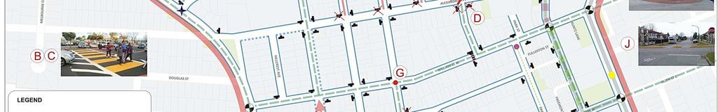
8 Scenario 2 Description of Measures ID Description Example Measure: Traffic calmed Neighbourhood signage Location: Various locations Rationale: Alert drivers that they are entering a traffic calmed neighbourhood Measure: Sidewalk Location: Various locations in the neighbourhood where sidewalks are currently missing Rationale: Enhance safety of pedestrians and encourage active transportation by providing designated space for pedestrians separate from vehicular travel Sidewalks to be implemented in accordance with a City wide sidewalk program that looks to address missing connections throughout the City. The program once developed will seek to prioritize locations on a City wide basis. Measure: Signed on road bike route Location: Roslin Avenue; William Street; Allen Street; Westmount Road; Erb Street; Park Street (south of Allen Street); Caroline Street (between William Street and Allen Street) Rationale: Encourage active transportation; Signage to raise driver awareness Measure: One way street Location: Segments of Dunbar Road, Avondale Avenue, Alexandra Avenue, and Norman Street Rationale: Discourage infiltration by creating indirect routes through the neighbourhood The width of the resulting roadway will need to be treated to discourage speeding and passing movements on the one way streets. Measures to be considered include curb extensions, pavement markings and/or on street parking (mobile planters may be used to help delineate on street parking sections). These details will be determined at the implementation stage. A Measure: Right turning restrictions from Westmount Road to Dawson Street, Dietz Avenue, B and Norman Street during peak periods (7:00 AM 9:00 AM and 4:00 PM 6:00 PM) C Location: Westmount Road at Dawson Street, Dietz Avenue, and Norman Street Rationale: Discourage northbound vehicles from by passing the Westmount Road / Erb Street intersection by using the neighbourhood streets D Measure: Right turning restrictions from Erb Street to Dietz Avenue, Beverly Street, Dunbar E Road, and Avondale Avenue during peak periods (7:00 AM 9:00 AM and 4:00 PM 6:00 F PM) G Location: Erb Street at Dietz Avenue, Beverly Street, Dunbar Road, and Avondale Avenue Rationale: Discourage eastbound vehicles on Erb Street and southbound vehicles from development on the north side of Erb Street from cutting through the neighbourhood H Measure: Raised crosswalk Location: Roslin Avenue at Lourdes Street Rationale: Reduce vehicular speeds along school frontage; Improve pedestrian crossing opportunities J Measure: Raised intersection Location: Alexandra Avenue / Roslin Avenue Rationale: Reduce vehicular speeds through the intersection in proximity to the school Scenario 2 Page 1 April 28, 2014
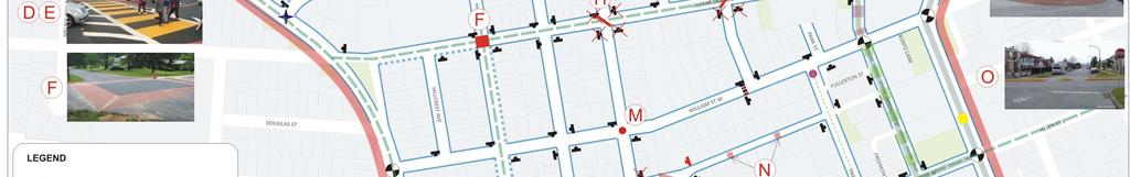
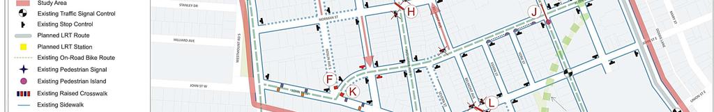
9 Scenario 2 Description of Measures ID Description Example K O L Measure: Diverter (stop controls are removed) Location: Alexandra Avenue / Euclid Avenue and John Street / Belmont Avenue Rationale: Discourage the use of Alexandra Avenue, Euclid Avenue, John Street, and Belmont Avenue as through routes Measure: Raised median islands (or speed cushions) Location: Mid block on Father David Bauer Drive Rationale: Reduce vehicular speeds on the approaches to / or cutting the 90 corner M Measure: Road closure (pedestrian and cyclist access to be maintained) Location: Roslin Avenue and Allen Street at John Street Rationale: Discourage Roslin Avenue and Allen Street as through routes; reduce conflicting vehicular movements at atypical intersection N Measure: Raised median island through intersection (emergency response vehicle access to be maintained) Location: Park Street / Allen Street Rationale: Discourage Allen Street as an east west through route; Address existing collision issue by removing left turning movements; Provide pedestrian refuge island on Park Street Note: Example photos are shown for illustration purposes only. Details of each measure are site specific and will be determined during the detailed design phase. Scenario 2 Page 2 April 28, 2014
10 Scenario 2 Advantages and Disadvantages Criteria Advantages Disadvantages Provides access during non peak times for Changes existing character of neighbourhood residents and other visitors travelling on streets. Westmount Road and Erb Street. Reduces route options for residents returning to Reduces opportunities for traffic on Westmount neighbourhood during peak times (i.e. less Road and Erb Street to enter neighbourhood opportunities for turning into neighbourhood streets. from Westmount Road and from Erb Street). Potential to enhance community space through Some residents will be faced with circuitous the design of some measures (i.e. diverters and routes for access / egress because of one way road closure). street segments, diverters, closures and turning restrictions (during peak times). Traffic Encourages slower traffic speeds with raised Introduces barriers that create challenging / Community Operations Infiltration Safety Cost crosswalk and raised intersection on Roslin Avenue near the school. Measures to discourage infiltration include: turning restrictions on Westmount Road turning restrictions on Erb Street diverters raised crosswalk raised intersection median islands (or speed cushions) one way segments road closure intersection median island Reduces traffic speeds near school with raised crosswalk and raised intersection. Addresses collision issues at Park Street / Allen Street with intersection median island that eliminates some conflicting turn movements. Improves safety at Roslin Avenue / Allen Street / John Street with closure that eliminates conflicting turn movements. Reduces conflicting movements on one way streets (i.e. no opposing traffic). Raises driver awareness and encourages active transportation with on road bike routes and appropriate signage. Improves conditions for pedestrians by providing additional sidewalks (as per City s sidewalk program) where currently missing. circuitous routes for emergency response vehicles. An increase in traffic volumes may result on some street segments due to circuitous routes made by other neighbourhood residents. An increase in traffic speeds may result on oneway street segments or those without implemented measures. Turn restrictions along Westmount Road and Erb Street will also impact neighbourhood residents returning home and patrons of Erb Street Mennonite Church. Residents on one way streets and near diverters will have limited route choice for access / egress. Turn restrictions to or from Regional roads (i.e. Westmount Road and Erb Street) will need approval from Region of Waterloo. An increase in traffic volumes may result on Roslin Avenue across school frontage as access to school must be maintained. An increase in traffic speeds may result on oneway streets due to reduced friction. Stop control and clear signage (one way and do not enter) needed to alert drivers approaching one way streets. Non compliance on one way street segments may occur. Non compliance for turning restrictions may occur. Significant cost to implement. Increases snow clearing, garbage and recycling collection costs due to additional time required for one way street segments (requiring looping around to access both sides of the street). If used to help control speeds on longer one way streets, then portable pinch points will require maintenance and winter storage. Permanent pinch points will have a higher installation cost. Scenario 2 Page 3 April 28, 2014
11
12 Scenario 3 Description of Measures ID Description Example Measure: Traffic calmed Neighbourhood signage Location: Various locations Rationale: Alert drivers that they are entering a traffic calmed neighbourhood Measure: Sidewalk Location: Various locations in the neighbourhood where sidewalks are currently missing Rationale: Enhance safety of pedestrians and encourage active transportation by providing designated space for pedestrians separate from vehicular travel Sidewalks to be implemented in accordance with a City wide sidewalk program that looks to address missing connections throughout the City. The program once developed will seek to prioritize locations on a City wide basis. Measure: Signed on road bike route Location: Roslin Avenue; Alexandra Avenue; Allen Street; Westmount Road; Erb Street; Park Street (south of Allen Street); Caroline Street (between William Street and Allen Street) Rationale: Encourage active transportation; Signage to raise driver awareness Measure: One way street Location: Segments of Dawson Street, Norman Street, and Dunbar Road Rationale: Discourage infiltration by creating indirect routes through the neighbourhood A H J P B C D E F The width of the resulting roadway will need to be treated to discourage speeding and passing movements on the one way streets. Measures to be considered include curb extensions, pavement markings and/or on street parking (mobile planters may be used to help delineate on street parking sections). These details will be determined at the implementation stage. Measure: Diverter (stop controls are removed) Location: Dawson Street / Dietz Avenue; Alexandra Avenue / Avondale Avenue; Alexandra Avenue / Euclid Avenue; John Street / Belmont Avenue Rationale: Discourage the use of Dawson Street, Dietz Avenue, Alexandra Avenue, Avondale Avenue, Euclid Avenue, John Street, and Belmont Avenue as through routes Measure: Right turning restriction from Beverly Street to Erb Street and from Roslin Avenue to Erb Street during peak periods (7:00 AM 9:00 AM and 4:00 PM 6:00 PM) Location: Beverly Street; Roslin Avenue at Erb Street Rationale: Discourage northbound vehicles on Westmount Road from by passing the Westmount Road / Erb Street intersection by using the neighbourhood streets and exiting to Erb Street at Beverly Street or Roslin Avenue Measure: Raised crosswalk Location: Lourdes Street at Dietz Avenue; Roslin Avenue at Lourdes Street Rationale: Reduce vehicular speeds in the vicinity of the school and along the school frontage; Improve pedestrian crossing opportunities Measure: Raised intersection Location: Alexandra Avenue / Roslin Avenue Rationale: Reduce vehicular speeds through the intersection in proximity to the school Scenario 3 Page 1 April 28, 2014
 Location: Mid block on Father David Bauer Drive")
13 Scenario 3 Description of Measures ID Description Example G N Measure: Pinch point using mobile planter or similar Location: Dunbar Road; Norman Street Rationale: Reduce vehicular speeds in the vicinity of the measure; Discourage the use of Dunbar Road and Norman Street as through routes K Measure: Raised median islands (or speed cushions) Location: Mid block on Father David Bauer Drive Rationale: Reduce vehicular speeds on the approaches to / or cutting the 90 corner L Measure: Road closure (pedestrian and cyclist access to be maintained) Location: Roslin Avenue and Allen Street at John Street Rationale: Discourage Roslin Avenue and Allen Street as through routes; reduce conflicting vehicular movements at atypical intersection M Measure: Traffic circle Location: William Street / Avondale Avenue Rationale: Reduce vehicular speeds on the approaches to the intersection with no significant impact to emergency response vehicles O Measure: Raised median island through intersection (emergency response vehicle access to be maintained) Location: Park Street / Allen Street Rationale: Discourage Allen Street as an east west through route; Address existing collision issue by removing left turning movements; Provide pedestrian refuge island on Park Street Note: Example photos are shown for illustration purposes only. Details of each measure are site specific and will be determined during the detailed design phase. Scenario 3 Advantages and Disadvantages Criteria Advantages Disadvantages Community Residents and other visitors travelling on Westmount Road and Erb Street can access the neighbourhood at various locations. Discourages traffic on Westmount Road and Erb Street to cut through neighbourhood streets through measures within the neighbourhood. Potential to enhance community space through the design of some measures (i.e. diverters and road closure). Changes existing character of neighbourhood streets. Some residents will be faced with circuitous routes because of one way street segments, diverters, closures, and turning restrictions (during peak times). Scenario 3 Page 2 April 28, 2014
14 Scenario 3 Advantages and Disadvantages Criteria Advantages Disadvantages Traffic Encourages slower traffic speeds with raised Introduces barriers that create challenging / Operations crosswalks and raised intersection on Lourdes Street and Roslin Avenue near the school. Encourages slower traffic speeds with traffic circle at William Street / Avondale Avenue. Encourages lower speeds on Dunbar Road and Norman Street by strategically creating pinch points (mobile planters or similar or mid block curb extensions). circuitous routes for emergency response vehicles. An increase in traffic volumes may result on some street segments due to circuitous routes made by other neighbourhood residents. An increase in traffic speeds may result on oneway street segments or those without implemented measures. Higher traffic volumes may result on Roslin Avenue as parallel streets (Dunbar Road, Avondale Avenue, Menno Street, and Euclid Avenue) have measures that discourage access. Infiltration Measures to discourage infiltration include: turning restrictions on to Erb diverters raised crosswalks raised intersection pinch points median islands (or speed cushions) one way segments traffic circle road closure intersection median island Turn restrictions from Beverly Street on to Erb Street and from Roslin Avenue on to Erb Street will also impact residents exiting the neighbourhood. Residents on one way streets and near diverters will have limited route choice for access / egress. Traffic travelling on Westmount Road and Erb Street can still access the neighbourhood from various locations. Turn restrictions to or from Regional roads (i.e. Erb Street) will need approval from Region of Waterloo. Safety Cost Reduces traffic speeds near school with raised crosswalks and raised intersection. Addresses collision issues at Park Street / Allen Street with intersection median island that eliminates some conflicting turn movements. Improves safety at Roslin Avenue / Allen Street / John Street with closure that eliminates conflicting turn movements. Reduces conflicting movements on one way streets (i.e. no opposing traffic). Raises driver awareness and encourages active transportation with on road bike routes and appropriate signage. Improves conditions for pedestrians by providing additional sidewalks (as per City s sidewalk program) where currently missing. An increase in traffic volumes may result along Roslin Avenue across school frontage as access to school must be maintained. An increase in traffic speeds may result on oneway streets due to reduced friction. Stop control and clear signage (one way and do not enter) needed to alert drivers approaching one way streets. Non compliance on one way street segments may occur. Non compliance for turning restrictions may occur. Significant cost to implement. Increases snow clearing, garbage and recycling collection costs due to additional time required for one way street segments (requiring looping around to access both sides of the street). Portable pinch points will require maintenance and winter storage. Permanent pinch points will have a higher installation cost. Scenario 3 Page 3 April 28, 2014
15
16 Scenario 4 Description of Measures ID Description Example Measure: Traffic calmed Neighbourhood signage Location: Various locations Rationale: Alert drivers that they are entering a traffic calmed neighbourhood Measure: Sidewalk Location: Various locations in the neighbourhood where sidewalks are currently missing Rationale: Enhance safety of pedestrians and encourage active transportation by providing designated space for pedestrians separate from vehicular travel Sidewalks to be implemented in accordance with a City wide sidewalk program that looks to address missing connections throughout the City. The program once developed will seek to prioritize locations on a City wide basis. Measure: Signed on road bike route Location: Roslin Avenue (Erb Street to William Street); Avondale Avenue (William Street to John Street); Euclid Avenue (Erb Street to William Street); William Street; Allen Street; Westmount Road; Erb Street; Park Street (south of Allen Street); Caroline Street (between William Street and Allen Street) Rationale: Encourage active transportation; Signage to raise driver awareness Measure: One way street Location: Segments of Roslin Avenue; Dunbar Road; Avondale Avenue; Menno Street; Belmont Avenue Rationale: Discourage infiltration by creating indirect routes through the neighbourhood The width of the resulting roadway will need to be treated to discourage speeding and passing movements on the one way streets. Measures to be considered include curb extensions, pavement markings and/or on street parking (mobile planters may be used to help delineate on street parking sections). These details will be determined at the implementation stage. A Measure: Diverter (stop controls are removed) D Location: Dawson Street / Dietz Avenue; Alexandra Avenue / Euclid Avenue; Norman Street / H Avondale Avenue; John Street / Belmont Avenue L Rationale: Discourage the use of Dawson Street, Dietz Avenue, Alexandra Avenue, Euclid Avenue, Norman Street, Avondale Avenue, John Street, and Belmont Avenue as through routes B Measure: Raised crosswalk C Location: Lourdes Street at Dietz Avenue; Roslin Avenue at Lourdes Street Rationale: Reduce vehicular speeds in the vicinity of the school and along the school frontage; Improve pedestrian crossing opportunities E Measure: Raised median islands (or speed cushions) Location: Mid block on Father David Bauer Drive Rationale: Reduce vehicular speeds on the approaches to / or cutting the 90 corner Scenario 4 Page 1 April 28, 2014

17 Scenario 4 Description of Measures ID Description Example F K Measure: Half road closure (with appropriate do not enter and turn restriction signage) Location: Allen Street at John Street; Roslin Avenue at John Street Rationale: Discourage Roslin Avenue and Allen Street as through routes G Measure: Traffic circle Location: William Street / Avondale Avenue Rationale: Reduce vehicular speeds on the approaches to the intersection with no significant impact to emergency response vehicles J Measure: Raised median island through intersection (emergency response vehicle access to be maintained) Location: Park Street / Allen Street Rationale: Discourage Allen Street as an east west through route; Address existing collision issue by removing left turning movements; Provide pedestrian refuge island on Park Street Note: Example photos are shown for illustration purposes only. Details of each measure are site specific and will be determined during the detailed design phase. Scenario 4 Advantages and Disadvantages Criteria Advantages Disadvantages Community Residents and other visitors travelling on Westmount Road and Erb Street can still access the neighbourhood at various locations. Discourages traffic on Westmount Road and Erb Street to cut through neighbourhood streets through measures within the neighbourhood. Potential to enhance community space through the design of some measures (i.e. diverters and road closure). Changes existing character of neighbourhood streets. Some residents will be faced with circuitous routes because of one way street segments, diverters, and half closures. Traffic Encourages slower traffic speeds with raised Introduces barriers that create challenging / Operations crosswalks on Lourdes Street and Roslin Avenue near the school. Encourages slower traffic speeds with traffic circle at William Street / Avondale Avenue. circuitous routes for emergency response vehicles. An increase in traffic volumes may result on some street segments due to circuitous routes made by other neighbourhood residents. An increase in traffic speeds may result on oneway street segments or those without implemented measures. Higher traffic volumes may be observed on Roslin Avenue as parallel streets (Dunbar Road, Avondale Avenue, Menno Street, and Euclid Avenue) have measures that discourage access. Infiltration Measures to discourage infiltration include: diverters raised crosswalks median islands (or speed cushions) one way segments traffic circle half closure intersection median island Residents on one way streets and near diverters will have limited route choice for access / egress. Traffic travelling on Westmount Road and Erb Street can still access the neighbourhood from various locations. Scenario 4 Page 2 April 28, 2014
18 Scenario 4 Advantages and Disadvantages Criteria Advantages Disadvantages Safety Slows vehicles on Roslin Avenue near the school by introducing raised crosswalks. Raised median through the intersection addresses collision issues at Park Street / Allen Street by reducing conflicting movements. Half closures at Roslin Avenue / John Street and Allen Street / John Street reduces some conflicting turning movements. Reduces conflicting movements on one way streets (i.e. no opposing traffic). An increase in traffic volumes may result along Roslin Avenue across school frontage as access to school must be maintained. An increase in traffic speeds may result on oneway streets due to reduced friction. Stop control and clear signage (one way and do not enter) needed to alert drivers approaching one way streets. Non compliance on one way street segments may occur. Signage identifying on road bicycle routes raises driver awareness and encourages active transportation at these locations. Improves conditions for pedestrians by providing additional sidewalks (as per City s sidewalk program). Encourages lower speeds near William Street / Avondale Avenue by introducing a traffic circle. Cost Significant cost to implement. Increases snow clearing, garbage and recycling collection costs due to additional time required for one way street segments (requiring looping around to access both sides of the street). If used to help control speeds on longer one way streets, then portable pinch points will require maintenance and winter storage. Permanent pinch points will have a higher installation cost. Scenario 4 Page 3 April 28, 2014
2014/2015 BIKE ROUTE PLAN 83 AVENUE PROTECTED BIKE LANE
 About the Project The City of Edmonton is planning a major bike route on the southside of Edmonton. The Strathcona Bike Route will connect the communities of Strathcona, Garneau and the University area,
2014/2015 BIKE ROUTE PLAN 83 AVENUE PROTECTED BIKE LANE
 About the Project 2014/2015 BIKE ROUTE PLAN The City of Edmonton is planning a major bike route on the south side of Edmonton. This bike route is one part of a plan to provide citizens with transportation
WELCOME Public Information Centre
 WELCOME Public Information Centre Fernforest Drive Brampton Soccer Centre Community Room #2 Tuesday January 19, 2016 6:30 p.m.to 9:00 p.m. Please sign in Neighbourhood Traffic Calming Guide Background
Public Information Centre
 WELCOME Public Information Centre Father Tobin Road Lougheed Middle School - Library Wednesday November 7, 2012 7:00 p.m.to 9:00 p.m. Please sign in Neighbourhood Traffic Calming Guide Background The City
Appendix C. TRAFFIC CALMING PROGRAM TOOLBOX
 Appendix C. TRAFFIC CALMING PROGRAM TOOLBOX PHASE I...2 Do Not Enter Sign...3 One-Way Sign...4 Turn Prohibition...5 Pavement Markings...6 Speed Monitoring Trailer...7 Neighborhood Speed Watch...8 Police
Tonight is for you. Learn everything you can. Share all your ideas.
 Strathcona Neighbourhood Renewal Draft Concept Design Tonight is for you. Learn everything you can. Share all your ideas. What is Neighbourhood Renewal? Creating a design with you for your neighbourhood.
CITY OF OTTAWA ROADWAY MODIFICATION APPROVAL UNDER DELEGATED AUTHORITY
 RMA-2015-ATM-038 CITY OF OTTAWA ROADWAY MODIFICATION APPROVAL UNDER DELEGATED AUTHORITY DATE: April 22, 2015 SUBJECT Approval of Roadway Modifications Recommended through an Area Traffic Management Study
Edenbrook Hill Drive Traffic Calming Study
 WELCOME Public Information Centre Edenbrook Hill Drive Traffic Calming Study Fletchers Meadow Secondary School Wednesday January 20, 2016 6:30 p.m.to 9:00 p.m. Please sign in Neighbourhood Traffic Calming
122 Avenue: 107 Street to Fort Road
 : 107 Street to Fort Road November 24, 2015 4:30 8:00 p.m. Meeting Purpose Summarize project work completed to date Share results of public input from Phase 1 Share the draft concept plan and proposed
Massey Place Neighbourhood Traffic Review
 Massey Place Neighbourhood Traffic Review Thursday, April 12, 2018 7:00pm - 9:00pm transportation division 1 Outline Neighbourhood Traffic Review (NTR) Process Massey Place Schedule Sources of Information
Saskatchewan Drive Roadway Rehabilitation and Shared-Use Path Widening
 Saskatchewan Drive Roadway Rehabilitation and Shared-Use Path Widening We are here today to present the draft plan for the Saskatchewan Drive Roadway Rehabilitation and Shared-Use Path Widening project
Cycle Track Design Best Practices Cycle Track Sections
 Design Best Practices Sections It is along street segments where the separation and protection methods of cycle tracks offer more comfort than conventional bicycle lanes, and are more attractive to a wide
Broad Street Bicycle Boulevard Design Guidelines
 Broad Street Bicycle Boulevard Design Guidelines Building from the strategies introduced in the 2013 Bicycle Transportation Plan and community input received thus far, City Transportation Staff have identified
Southside Road. Prepared for: City of St. John s Police & Traffic Committee. Prepared by: City of St. John s Traffic Division
 Southside Road Prepared for: City of St. John s Police & Traffic Committee Prepared by: City of St. John s Traffic Division January 2007 Southside Road - Traffic Report Page 1 of 9 BACKGROUND: th At the
TRAFFIC CALMING GUIDE FOR TORONTO CITY OF TORONTO TRANSPORTATION SERVICES DIVISION
 TRAFFIC CALMING GUIDE FOR TORONTO CITY OF TORONTO TRANSPORTATION SERVICES DIVISION CITY OF TORONTO TRANSPORTATION SERVICES DIVISION 2016 TRAFFIC CALMING GUIDE FOR TORONTO TABLE OF CONTENTS Introduction
Major Bike Routes 102 Avenue Workshop April 21, 2015
 Major Bike Routes 102 Avenue Workshop April 21, 2015 Our Purpose Today Provide context on how Major Bike Routes fit into Edmonton s future Share information on what we heard in our last phase, and how
South Park Street Bicycle Lane Improvements. Public Engagement. November 2017
 South Park Street Bicycle Lane Improvements Public Engagement November 2017 South Park Street Bicycle Lane Improvements WHAT WE HEARD REPORT Introduction To improve safety and bicycle route continuity
CITY OF HAMILTON PLANNING AND ECONOMIC DEVELOPMENT DEPARTMENT Transportation Planning and Parking Division
 CITY OF HAMILTON PLANNING AND ECONOMIC DEVELOPMENT DEPARTMENT Transportation Planning and Parking Division TO: Chair and Members Public Works Committee COMMITTEE DATE: June 18, 2018 SUBJECT/REPORT NO:
MCARTHUR AVENUE AS WE HEARD IT REPORT CYCLING LANES. City of Ottawa Transportation Services. Photo: istock
 MCARTHUR AVENUE CYCLING LANES Photo: istock AS WE HEARD IT REPORT City of Ottawa Transportation Services CONTENTS Background...1 Consultation Activities Summary...1 Public Commentary Questionnaire Results...2
CLOSED. The draft concept design has been broken down into 5 categories for the purpose of this survey:
 Old Strathcona s neighbourhood renewal process is now at the draft concept design phase. Over the last several months, the city has been gathering local knowledge and resident input that has been used
TRAFFIC CALMING REVIEW MAX BECKER DRIVE INFORMATION PACKAGE AND PUBLIC COMMENT FORM
 TRAFFIC CALMING REVIEW MAX BECKER DRIVE INFORMATION PACKAGE AND PUBLIC COMMENT FORM Wednesday, May 31, 2017 Presentation: 7:00pm 9:00pm WT Townshend Public School 245 Activa Avenue BACKGROUND: Transportation
Downey Road. Transportation Improvement Study
 Downey Road Transportation Improvement Study Workshop 2 Participant Handbook Workshop 1 May 18 and 19, 2016 Workshop 2 June 23 and 28, 2016 Prepared By: City of Guelph Paradigm Transportation Solutions
DEPARTMENT OF ENVIRONMENTAL SERVICES. North Harrison Street (Lee Highway to Little Falls Road) Comparative Analysis. Prepared for:
 Comparative Analysis. Prepared for:") DEPARTMENT OF ENVIRONMENTAL SERVICES North Harrison Street (Lee Highway to Little Falls Road) Comparative Analysis Prepared for: Arlington County Department of Environmental Services 2100 Clarendon Boulevard,
DEPARTMENT OF ENVIRONMENTAL SERVICES North Harrison Street (Lee Highway to Little Falls Road) Comparative Analysis Prepared for: Arlington County Department of Environmental Services 2100 Clarendon Boulevard,
Memorandum. Sunday, July 13, Saturday, July 19, 2014
 Memorandum To: David Lowin, Brooklyn Bridge Park Corporation From: Daniel Schack, AICP, PTP Date: Re: Brooklyn Bridge Park Pier 5/6 Loop Road Traffic Study Project No: 14-01-2407 At the request of Brooklyn
POLICY: TRAFFIC CALMING
 2006 MAY REFERENCE: COUNCIL APPROVED BY COUNCIL MAY 23, 2006 CITY OPERATIONS - NO. 608 POLICY: TRAFFIC CALMING A. All requests for traffic calming within the City shall be considered in accordance with
Alternative Traffic Calming Methods
 Alternative Traffic Calming Methods In-street Pedestrian Crossing Sign Cost: approximately $300 per sign not including the installation cost Advantages of in-street pedestrian crossing signs 1. Typically
CITY OF WEST KELOWNA COUNCIL POLICY MANUAL
 CITY OF WEST KELOWNA COUNCIL POLICY MANUAL Page 1 of 7 DEPARTMENT: Engineering Services SUBJECT: Traffic Calming Policy (Revised June 6, 2017) Policy Statement: The provision of traffic calming measures
HIGHBURY AVENUE/HAMILTON ROAD INTERSECTION IMPROVEMENTS PUBLIC INFORMATION CENTRE 1 MAY 14, 2015
 HIGHBURY AVENUE/HAMILTON ROAD INTERSECTION IMPROVEMENTS Municipal Class Environmental Assessment PUBLIC INFORMATION CENTRE 1 MAY 14, 2015 ACCESSIBILITY Under the Accessibility Standards 2015 for Customer
Traffic Management and Mitigation Study in the Leslieville Community Transportation Services Division & IBI Group IBI GROUP
 Traffic Management and Mitigation Study in the Leslieville Community Transportation Services Division & IBI Group IBI GROUP July 18, 2018 Study Background and Objectives Background - Many development projects
SAN FRANCISCO MUNICIPAL TRANSPORTATION AGENCY
 THIS PRINT COVERS CALENDAR ITEM NO. : 11 DIVISION: Sustainable Streets BRIEF DESCRIPTION: SAN FRANCISCO MUNICIPAL TRANSPORTATION AGENCY Approving traffic modifications on Twin Peaks Boulevard between Christmas
Weston Downs Traffic Study City of Vaughan. Appendix B. Public Consultation Materials. Page 1
 Weston Downs Traffic Study City of Vaughan Appendix B Public Consultation Materials Page 1 Weston Downs Traffic Study City of Vaughan Community Action Committee Meeting 1 May 05, 2016 Page 30 Weston Downs
CLOSED. Highlights of the Final Concept Design:
 The final Concept Design is the result of many months of listening, learning, creating, balancing, and understanding different needs and viewpoints, as well as incorporating technical requirements and
CITY OF SAINT JOHN TRAFFIC CALMING POLICY
 CITY OF SAINT JOHN TRAFFIC CALMING POLICY VERSION: 1.0 April 10, 2012 Pedestrians, Cyclists and Motorists Sharing Street Spaces CONTENTS INTRODUCTION... 3 POLICY GOAL... 3 POLICY OBJECTIVES... 3 GUIDING
City of Seattle Edward B. Murray, Mayor
 City of Seattle Edward B. Murray, Mayor Department of Transportation Scott Kubly, Director Eastlake Community Council 117 E Louisa St. #1 Seattle, WA 98102-3278 January 28, 2016 RE: Roosevelt to Downtown
Richmond-Adelaide Cycle Tracks
 Public Drop-In Event Richmond-Adelaide Cycle Tracks June 25, 2018 12:00 p.m. 3:00 p.m. 4:30 p.m. 7:30 p.m. Metro Hall, Rotunda 55 John Street 1 Purpose of Event In Scope Communicate an update about the
complete streets design and construction standards public primer City of Edmonton
 complete streets design and construction standards public primer City of Edmonton introduction Complete Streets are streets for everyone: people who walk, wheel, bike, take transit, or drive. They are
Leaside Traffic Calming Plan Update. Community Meeting 2 November 22, :00 PM
 Leaside Traffic Calming Plan Update Community Meeting 2 November 22, 2016 7:00 PM Welcome and Study Background Welcome and Thank You! Study background from LPOA s perspective: Why are we doing this study?
TRAFFIC CALMING REVIEW DAIMLER DRIVE INFORMATION PACKAGE AND PUBLIC COMMENT FORM
 TRAFFIC CALMING REVIEW DAIMLER DRIVE INFORMATION PACKAGE AND PUBLIC COMMENT FORM Tuesday May 16, 2017 Presentation at 7:00 p.m. Lackner Woods Public School 151 Zeller Drive BACKGROUND: Transportation Services
Intersection Improvement: Sturgeon Road, Silver Avenue and Murray Park Road Roundabout. Welcome. Public Information Session
 Intersection Improvement: 1 Welcome WHY IS AN INTERSECTION IMPROVEMENT NEEDED? 2 Traffic volumes for Sturgeon Road, Silver Avenue and Murray Park Road exceed the capacity of the existing 4-way stop controlled
Byron Avenue. Public Meeting. Thursday June 16, Traffic Calming Design Sherbourne Road to Island Park Drive
 Byron Avenue Traffic Calming Design Sherbourne Road to Island Park Drive Public Meeting Thursday June 16, 2016 Our Lady of Fatima Parish 153 Woodroffe Avenue 6 9pm 1 Project Summary Area Projects Background
TRAFFIC ACTION PLAN. Laurie Meadows Neighborhood CITY OF SAN MATEO
 TRAFFIC ACTION PLAN Laurie Meadows Neighborhood CITY OF SAN MATEO Draft January 2017 Table of Contents Introduction... 2 The Traffic Forum Process... 5 Neighborhood Traffic Issues... 7 Neighborhood Recommendations
City of Sammamish. Welcome. Issaquah-Fall City Road Improvements Project Phase I Design: 242nd Avenue SE to Klahanie Drive SE
 Welcome Welcome to the third community meeting for the Issaquah-Fall City Road Improvements Project. AGENDA 6:00 p.m. Welcome and sign-in 6:10 p.m. Presentation 6:50 p.m. Open house Learn about the roadway
Draft North Industrial Area-Wide Traffic Plan
 Summary of North Industrial and Hudson Bay Industrial Recommended Improvements Table 1. Summary of s Item Location 1 2 3 4 5 6 7 8 9 10 11 12 Millar Ave north of 51st St Super 8 Motel back lane 400 Block
Complete Streets for Niagara A working method to visualize the creation of a complete street June 20th, 2013
 Complete Streets for Niagara A working method to visualize the creation of a complete street June 20th, 2013 C O N T E N T S Introduction and background of the report What is a complete street? What can
Dewey Area Traffic Calming Project
 SFMTA Municipal Transportation Agency Image: Crosswalk of California Street and Grant Avenue Dewey Area Traffic Calming Project 10 08 2013 SAN FRANCISCO, CALIFORNIA Tonight s Agenda Introductions Project
PEDESTRIAN ACTION PLAN
 ATTACHMENT 2 CITY OF SANTA MONICA PEDESTRIAN ACTION PLAN CITY OF SANTA MONICA PEDESTRIAN ACTION PLAN This page intentionally left blank EXECUTIVE SUMMARY CHAPTER 1 EXECUTIVE SUMMARY Setting the Stage
EUCLID AVENUE PARKING STUDY CITY OF SYRACUSE, ONONDAGA COUNTY, NEW YORK
 EUCLID AVENUE PARKING STUDY CITY OF SYRACUSE, ONONDAGA COUNTY, NEW YORK CITY OF SYRACUSE DEPARTMENT OF PUBLIC WORKS 1200 CANAL STREET EXTENSION SYRACUSE, NEW YORK 13210 DRAFT REPORT DATE: November 13,
Multi-Modal Traffic Analysis. Parisi and Associates
 Mill Valley to Corte Madera Bicycle and Pedestrian Corridor Study Appendix D: Multi-Modal Traffic Analysis Prepared by Parisi and Associates August 2009 Appendix D - Multi-Modal Traffic Analysis Table
Corporate. Report COUNCIL DATE: May 25, 1998 NO: R1500 REGULAR COUNCIL. TO: Mayor & Council DATE: April 27, 1998
 R1500 : Traffic Safety at 25 Avenue and 128 Street Intersection Corporate NO: R1500 Report COUNCIL DATE: May 25, 1998 REGULAR COUNCIL TO: Mayor & Council DATE: April 27, 1998 FROM: General Manager, Engineering
Gateway Signs. Description: Sign reminding drivers of the need to drive slowly Issues addressed: speeding Cautions/Limitations: Application:
 Level 1 Limited Application Gateway Signs Description: Sign reminding drivers of the need to drive slowly Issues addressed: speeding Increased motorist awareness of the neighborhood character Provides
TOWN OF HALTON HILLS TRAFFIC CALMING PROTOCOL. Page 1 of 25
 TOWN OF HALTON HILLS TRAFFIC CALMING PROTOCOL Page 1 of 25 PROCESS FOR INSTALLATION OF TRAFFIC CALMING DEVICES The Process for Installation of Traffic Calming Devices has been prepared to provide an objective
BETHEL ROAD AND SEDGWICK ROAD CORRIDOR STUDY
 DRAFT PLAN City Council Meeting August 14, 2017 STUDY AREA Sedgwick Corridor State Route 160, principal arterial with Class 3 access management designation, commuter and freight route, connection to SR
CITY OF COCOA BEACH 2025 COMPREHENSIVE PLAN. Section VIII Mobility Element Goals, Objectives, and Policies
 CITY OF COCOA BEACH 2025 COMPREHENSIVE PLAN Section VIII Mobility Element Goals, Objectives, and Policies Adopted August 6, 2015 by Ordinance No. 1591 VIII MOBILITY ELEMENT Table of Contents Page Number
Seattle Department of Transportation (SDOT) Preliminary Responses to Madison-Miller Community List of Site-Specific Concerns
 Preliminary Responses to Madison-Miller Community List of Site-Specific Concerns") Seattle Department of Transportation (SDOT) Preliminary Responses to Madison-Miller Community List of Site-Specific Concerns Background In July 2002 SDOT staff met with a small group of community residents
Seattle Department of Transportation (SDOT) Preliminary Responses to Madison-Miller Community List of Site-Specific Concerns Background In July 2002 SDOT staff met with a small group of community residents
Pattullo Bridge Replacement Project Community Connections Phase 2 Consultation. Appendix 3: Open House Display Boards
 Replacement Project Community Connections Phase 2 Consultation Appendix 3: Open House Display Boards November 2016 Welcome! Welcome to the Replacement Project Public Open House We Want to Hear from You
REPORT. Engineering and Construction Department
 REPORT COMMUNITY SERVICES COMMITTEE MEETING DATE: JUNE 11, 2013 FROM: Engineering and Construction Department DATE: May 24, 2013 SUBJECT: Great Lakes Boulevard Mini Roundabout LOCATION: Great Lakes Boulevard
SFMTA PROJECT TIMELINE
 SFMTA PROJECT TIMELIE Internal SFMTA Processes Opportunities for Public Input Data Collection and Analysis Car and bike volumes, safety (collision) data Roadway and intersection geometry June 2016 Pop
5. RUNNINGWAY GUIDELINES
 5. RUNNINGWAY GUIDELINES These guidelines should be considered collectively when making runningway decisions. A runningway is the linear component of the transit system that forms the right-of-way reserved
Governance and Priorities Committee Report For the July 2, 2015 Meeting
 CITY OF VICTORIA For the July 2, 2015 Meeting To: Governance and Priorities Committee Date: From: Subject: Brad Dellebuur, A/Assistant Director, Transportation and Parking Services Executive Summary The
Welcome to the Quebec Alternatives Analysis Public Meeting
 Welcome to the Public Meeting Please sign in. Public Comment Please fill out a comment card and tell us what you think. Check back or comment any time at: www.quebecalternatives.com Project Area Technical
PROJECT OVERVIEW. 20th Avenue Project Limits (Lincoln Way to Wawona St)
") PROJECT OVERVIEW In 2014, San Francisco adopted Vision Zero as City policy, with a commitment to eliminate all traffic deaths in the City by 2024. nue Project Limits (Lincoln Way to St) Collision data
PROJECT OVERVIEW In 2014, San Francisco adopted Vision Zero as City policy, with a commitment to eliminate all traffic deaths in the City by 2024. nue Project Limits (Lincoln Way to St) Collision data
REPORT District of Maple Ridge
 REPORT District of Maple Ridge Traffic Calming Policy This report is prepared for the sole use of the District of Maple Ridge. No representations of any kind are made by Urban Systems Ltd. or its employees
West Broad Street Traffic Study
 West Broad Street Traffic Study Prepared for the Town of Plainville by Central Connecticut Regional Planning Agency (CCRPA) October 2011 Central Connecticut Regional Planning Agency 225 N. Main St. Suite
TRAFFIC CALMING TOOLBOX. For the residents of the City of Decatur, Georgia
 TRAFFIC CALMING TOOLBOX For the residents of the City of Decatur, Georgia 2 City of Decatur Traffic Calming Toolbox Public Works Department 2635 Talley Street Decatur, GA 30030 404.377.5571 3 Welcome to
Improving Cyclist Safety at the Dundas Street West and Sterling Road Intersection
 STAFF REPORT ACTION REQUIRED Improving Cyclist Safety at the Dundas Street West and Sterling Road Intersection Date: August 17, 2012 To: From: Wards: Reference Number: Public Works and Infrastructure Committee
NM-POLICY 1: Improve service levels, participation, and options for non-motorized transportation modes throughout the County.
 Transportation PRINCE WILLIAM COUNTY 2008 COMPREHENSIVE PLAN NON-MOTORIZED PLAN CONTENTS Goals, Policies, and Action Strategies Table 4 (Bike Facility Classifications and Descriptions) Table 5 (Bike Facility
2.0 LANE WIDTHS GUIDELINE
 2.0 LANE WIDTHS GUIDELINE Road Engineering Design Guidelines Version 2.0.1 May 2018 City of Toronto, Transportation Services City of Toronto Page 0 Background In early 2014, Transportation Services initiated
Dowling/Beaty Cycling Route
 Public Meeting #2 Dowling/Beaty Cycling Route May 17, 2017 6:00 p.m. 8:00 p.m. Parkdale Public Library - Auditorium 1303 Queen Street West How to Participate Share your questions, ideas and concerns We
TRAFFIC ACTION PLAN. North Shoreview Neighborhood CITY OF SAN MATEO
 TRAFFIC ACTION PLAN North Shoreview Neighborhood CITY OF SAN MATEO Draft February 2017 Table of Contents Introduction... 1 The Traffic Forum Process... 4 Neighborhood Traffic Issues... 6 Neighborhood Recommendations
Community Bicycle Planning
 Community Bicycle Planning City of Mentor s Bicycle Facility Plan Allen E. Pennington, P.E. Civil Engineer - Traffic Office of the Mentor City Engineer Why has Mentor participated in bicycle planning?
Chicago Safe Routes to School Safe Routes to High School (SRTS/SRTHS)
") Chicago Safe Routes to School Safe Routes to High School (SRTS/SRTHS) Marshall Community High School and Faraday Elementary School Recommended Improvements Agenda Goals Related Programs Project Location/Area
Chicago Safe Routes to School Safe Routes to High School (SRTS/SRTHS) Marshall Community High School and Faraday Elementary School Recommended Improvements Agenda Goals Related Programs Project Location/Area
Bicycle Boulevards and Neighborhood Greenways
 Bicycle Boulevards and Neighborhood Greenways Traffic Safety is Improving for Everyone 90 80 70 60 50 40 30 20 10 0 PORTLAND: TOTAL TRAFFIC FATALITIES 1986-2008 1986 1987 1988 1989 1990 1991 1992 1993
Transportation Planning Division
 Transportation Planning Division Presentation Outline Study Tasks Recap of Previous Meetings Data Collected Focus Areas within Study Limits Design Principles Tool Box Recommended Concepts Schedule Moving
TOWN OF PAYSON TRAFFIC CALMING MANUAL
 TOWN OF PAYSON TRAFFIC CALMING MANUAL APPROVED BY THE PAYSON TOWN COUNCIL SEPTEMBER 6, 2007 TOWN OF PAYSON TRAFFIC CALMING POLICY 1.0 Introduction Traffic Calming involves retrofitting physical devices
ALBERTA AVENUE WHAT WE HEARD REPORT BUILDING GREAT NEIGHBOURHOODS
 ALBERTA AVENUE WHAT WE HEARD REPORT BUILDING GREAT NEIGHBOURHOODS FEBRUARY 2019 EXECUTIVE SUMMARY Starting in 2019, Alberta Avenue will see the replacement and enhancement of its aging collector and local
CITY OF ORILLIA POLICY MANUAL
 Page 1 of 34 1 INTRODUCTION 1.1 Background The Public Works Department receives numerous concerns, both real and perceived, from residents regarding high traffic volumes, short-cutting, speeding and overall
City of Albert Lea Policy and Procedure Manual 4.10 ALBERT LEA CROSSWALK POLICY
 4.10 ALBERT LEA CROSSWALK POLICY PURPOSE: Pedestrian crosswalks are an integral part of our transportation infrastructure. To be effective and promote safety, marked crosswalks must be installed after
CITY OF WEST LAKE HILLS. Forest View Neighborhood Traffic Calming Study
 CITY OF WEST LAKE HILLS 901 South Mopac Expressway Building V, Suite 220 Austin, Texas 78746 Texas P.E. Firm Registration No. F-929 Klotz Associates Final Report Submittal: March 20, 2015 Revised Final
South Albion-Bolton Community Plan North Hill Supermarket Transportation Study Part B: Evaluation of Alternatives
 Community Plan North Hill Supermarket Transportation Study Part B: Evaluation of Alternatives Prepared for: The Town of Caledon August 9 Transportation Solutions Ltd. 43 Forest Road Cambridge, ON N1S 3B4
WALKNBIKE DRAFT PLAN NASHVILLE, TENNESSEE EXECUTIVE SUMMARY NASHVILLE, TENNESSEE
 NASHVILLE, TENNESSEE EXECUTIVE SUMMARY Executive Summary A world-class multi-modal transportation system is essential to a vibrant city and better quality of life. -Mayor Barry The WalknBike plan aims
Bellevue Downtown Association Downtown Bike Series
 Bellevue Downtown Association Downtown Bike Series Meeting 2 Franz Loewenherz Andreas Piller Kyle Potuzak Chris Long October 26, 2017 Today s Agenda: 1) Meeting Purpose 2) 9/28 Meeting Recap 3) Candidate
Traffic Calming Review. Max Becker Drive. Thursday, November 30, 2017 Presentation at 7:00 p.m. WT Townshend Public School
 Traffic Calming Review Max Becker Drive Thursday, November 30, 2017 Presentation at 7:00 p.m. WT Townshend Public School Agenda 1. Introductions 2. Traffic Calming Review Process 3. Study Area & Existing
City of Mountlake Terrace Traffic Calming Guide
 City of Mountlake Terrace Traffic Calming Guide A Guide For Managing Traffic in Mountlake Terrace Neighborhoods July 2017 City of Mountlake Terrace Department of Community and Economic Development Table
Coquitlam Cross-town Bike Route Improving Bicycle Facilities in a Mature Suburban Environment
 Coquitlam Cross-town Bike Route Improving Bicycle Facilities in a Mature Suburban Environment Sarah Rocchi, Vice-President, Projects, Opus International Consultants (Main Presenter) Catherine Mohoruk,
Brief Outline of the Neighborhood Traffic Management Program (NTMP)
") Brief Outline of the Neighborhood Traffic Management Program (NTMP) Typically, this is the process after Department of Public Works (DPW) receives a request for speed humps, complaints about speeding,
Brief Outline of the Neighborhood Traffic Management Program (NTMP) Typically, this is the process after Department of Public Works (DPW) receives a request for speed humps, complaints about speeding,
 COMPLETE STREETS CHECKLIST City of Philadelphia The City of Philadelphia's Complete Streets policies are designed ensure that city streets are safe, comfortable and convenient for people of all ages and
Thank you for attending the first Public Open House for the Thunder Bay Transportation Master Plan!
 Welcome Thank you for attending the first Public Open House for the Thunder Bay Transportation Master Plan! Please take this opportunity to learn about the study and to tell us your ideas and vision for
THE ALAMEDA CONCEPT DESIGN COMMUNITY MEETING 3. A Plan for The Beautiful Way JANUARY 28, 2010
 CONCEPT DESIGN COMMUNITY MEETING 3 JANUARY 28, 2010 AGENDA INTRODUCTION COMMUNITY INPUT ROADWAY STUDIES STREETSCAPE DESIGN STATIONS DISCUSSION SUMMARY AND DISCUSSION NEXT STEPS CLOSE INTRODUCTION SCHEDULE
6.4 RECOMMENDED IMPROVEMENTS
 6.4 RECOMMENDED IMPROVEMENTS 6.4.1 Williston Road Recommendations While all alternatives would be an improvement over existing conditions, Alternative 3B is recommended over the others because it provides
SAN FRANCISCO MUNICIPAL TRANSPORTATION AGENCY
 THIS PRINT COVERS CALENDAR ITEM NO. : 10.2 DIVISION: Sustainable Streets BRIEF DESCRIPTION: SAN FRANCISCO MUNICIPAL TRANSPORTATION AGENCY Adopting Conceptual Proposal for Streetscape Improvements to Broadway,
Welcome! San Jose Avenue Open House August 25, 2015
 Welcome! San Jose Avenue Open House August 25, 2015 Vision Zero The City and County of San Francisco adopted Vision Zero San Francisco Vision Zero High Injury Network as a policy in 2014, committing an
STONY PLAIN ROAD STREETSCAPE
 Jasper Place Revitalization Strategy: Vision The people involved in the Jasper Place Revitalization Strategy envision: Goal 1: Feeling safe in our community Create a community where feeling safe is common--where
Traffic Circulation & Pedestrian Safety Study
 Lyons Township High School North Campus La Grange, Illinois Parking Lot Vaughan Building N Main Building Prepared for: Prepared by: July 23, 2015 Contents List of Figures, iii 1. Introduction...1 2. Existing
DRAFT Montgomery County Bicycle Master Plan Design Toolkit
 DRAFT Montgomery County Bicycle Master Plan Design Toolkit Fall 2016 Sidepaths Sidepaths are shared use paths located parallel to and within the road right-of-way providing twoway travel for walking, bicycling,
Malvern Borough Local Traffic Calming
 Malvern Borough Local Traffic Calming Purpose: To address speeding and high volume cut-through traffic on Malvern Borough owned residential streets. Traffic Calming Measures: Traffic Calming Measures (TCM)
Make Lincoln Highway an economically vibrant corridor that is safe, efficient, and beautiful for local residents and visitors.
 Lincoln Highway Streetscape Plan Stakeholder Workshop #2 Handout Contents Introduction and Project Vision Planning Principles Specific Recommendations including a Proposed Typical Roadway Section Renderings
City of Lee s Summit, Missouri
 City of Lee s Summit, Missouri 1 of 10 ADOPTED MARCH 2008 TABLE OF CONTENTS I. INTRODUCTION II. NEIGHBORHOOD TRAFFIC STUDY III. EDUCATION IV. ENFORCEMENT V. ENGINEERING TRAFFIC CALMING TREATMENTS a. Background
Central Avenue Bikeway Traffic and Safety Impact Assessment
 FEBRUARY 2018 Lead Agency: San Diego Association of Governments (SANDAG) 401 B Street, Suite 800 San Diego, CA 92101 Contact: Chris Carterette, AICP, Project Manager 619.699.7319 chris.carterette@sandag.org
Watertown Complete Streets Prioritization Plan. Public Meeting #1 December 14, 2017
 Watertown Complete Streets Prioritization Plan Public Meeting #1 December 14, 2017 Goals for Public Meeting Overview of MassDOT Complete Streets Funding Program Educate the community on Complete Streets
25th Avenue Road Diet Project A One Year Evaluation. Transportation Fund for Clean Air Project #05R07
 25th Avenue Road Diet Project A One Year Evaluation Transportation Fund for Clean Air Project #05R07 Submitted by: The San Francisco Municipal Transportation Agency Dan Provence May 22, 2009 EXECUTIVE