connectivity through walking and cycling
|
|
|
- Amy Anderson
- 6 years ago
- Views:
Transcription

1 active design case study the national forest: connectivity through walking and cycling active design principles in action: 1. ACTIVITY FOR ALL 2. WALKABLE COMMUNITIES 3. CONNECTED WALKING & CYCLING ROUTES 7. APPROPRIATE INFRASTRUCTURE 10. ACTIVITY PROMOTION & LOCAL CHAMPIONS sportengland.org/activedesign


2 ACTIVE DESIGN CASE STUDY THE NATIONAL FOREST: CONNECTIVITY THROUGH WALKING & CYCLING THE NATIONAL FOREST USES THE PLANNING SYSTEM TO DEVELOP ITS GREEN INFRASTRUCTURE NETWORK. TO DATE 22% OF FOREST CREATION HAS BEEN ACHIEVED THROUGH THE PLANNING SYSTEM. Spanning parts of Staffordshire, Derbyshire and Leicestershire, The National Forest extends over 200 square miles. Over 25 years it has planted in excess of 8.5 million trees, creating an integrated green infrastructure network of cycling and walking routes through the creation of new woodland spaces. This network provides local communities with easy access to recreational opportunities on their doorstep and illustrates a number of Active Design principles. The National Forest is an excellent example of how working with new development within the Forest area can help to create a joined-up network of walking and cycling routes for both local residents and visitors. The Forest provides a green lung for the surrounding cities of Birmingham, Derby, Leicester and Nottingham with 10 million people living within 90 minutes drive. The National Forest uses the planning system to secure continued tree planting as well as developing its green infrastructure (GI) network. To date 22% of forest creation has been achieved through the planning system. This has been delivered by National Forest officers advising on existing and emerging development schemes and planning applications, contributing to the design and layout of the schemes, and embedding positive policies into the local authorities Local Plans. These policies all refer to the National Forest Guide for Developers and Planners. It [the guide] helps to tailor the benefits of including green infrastructure to the stage of the planning process. Initially we highlight that the inclusion of GI will help with obtaining outline permission, later on we ll speak to housebuilders about the specific benefits of GI and new access links to prospective occupiers. Philip Metcalfe (GI Planner for the National Forest Company) on lessons learnt through the planning process. Burtonupon-Trent Burtonupon-Trent Swadlincote Swadlincote Coalville Coalville National Forest tree cover from 1995 (above) to 2016 (right) THE NATIONAL FOREST: CONNECTIVITY THROUGH WALKING AND CYCLING

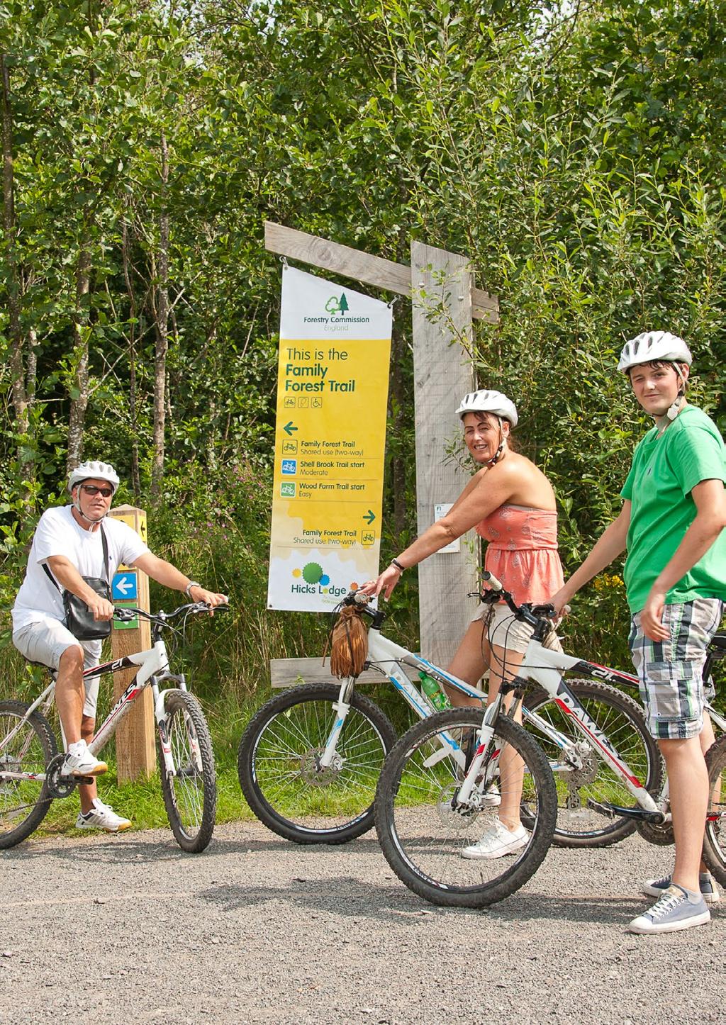
3 DELIVERING OPPORTUNITIES FOR RESIDENTS HICKS LODGE CYCLE CENTRE AND MEASHAM ROAD DEVELOPMENT The Hicks Lodge Cycle Centre opened in The National Forest in June It has 16km of purpose-built trails, paths, a café, bike shop and play area. Its design was a response to the demand for offroad cycling routes, particularly suited to the family audience. The cycle centre is based at a former opencast coal mine, which operated until the late 1990s. Its restoration offered the opportunity to create a substantial recreational asset to compliment the regeneration of the area. The site now acts as a hub within a network of trails and paths. Connected walking and cycling routes and walkable communities A housing development nearby, off Measham Road in Moira, created an opportunity to incorporate a cycle link that joined the cycle centre into the wider cycleway network of the Forest. This link, which runs the length of the site south west to north east, will give the new residents of the Measham Road development safe direct access to the off-road network. It also provides the missing link in the wider National Forest network providing a traffic-free route up to Hicks Lodge. Networks of multifunctional open space Hicks Lodge has created an opportunity for a wide range of groups to use the space around the centre, from parents and children to walking and running groups. The Adventure Play area, car park and open space close to the café create an environment to hold various events throughout the year. Clear signage and information helps to encourage users to try out a range of activities. It also helps users to know what the gradient and quality of the tracks are like and what they can be used for, such as horseriding, dog walking, cycling, outdoor education and orienteering. Access for all The design of the trails and paths caters for all levels; in particular for those who do not normally cycle or mountain bike. The centre provides a safe and accessible environment to allow users to develop their confidence on a bike. The main routes are suitable for wheelchairs and pushchairs and feature a range of gradients for all levels of ability, while also providing separate, more challenging areas for those who want to develop their skills further. HICKS LODGE HAS CREATED AN OPPORTUNITY FOR A WIDE RANGE OF GROUPS TO USE THE SPACE AROUND THE CENTRE, FROM PARENTS AND CHILDREN TO WALKING AND RUNNING GROUPS. SPORTENGLAND.COM/ACTIVEDESIGN

4 ACTIVE DESIGN CASE STUDY

5 BELLWAY HOMES, EFFLINCH LANE, BARTON UNDER NEEDWOOD, STAFFORDSHIRE This housing scheme sought to provide open space and woodland planting to connect the development to existing recreational routes and other housing areas. As part of the scheme over 50% of the site area was allocated for the creation of a multifunctional and accessible woodland, other habitat areas and open space. IT IS HOPED THAT BY CREATING NEW LINKS, RESIDENTS OF THE NEW DEVELOPMENT, AND THE EXISTING COMMUNITY, WILL NOT ONLY USE THE OPEN SPACE BUT ALSO EXPLORE THE EXTENSIVE NETWORK OF RECREATIONAL ROUTES ON THEIR DOORSTEP. Efflinch Lane development, Barton under Needwood, Staffordshire Connected walking and cycling routes & walkable communities Through the new open space and woodland the development connects to existing residential neighbourhoods to the west, Barton Marina to the north and a pedestrian crossing to employment land to the south. Barton Marina is situated on the Trent and Mersey canal and forms a 90 acre site, largely covered by woodland and open water, intersected by a network of paths and bridges. It is hoped that by creating new links to the Marina from the existing residential and employment areas, this open space will encourage new residents and the existing community to not only use the open space, but explore the extensive network of recreational routes on their doorstep. This is a great example that illustrates the advantages of connecting paths and routes into the wider paths system, extending the opportunities for new and existing residents to benefit from a larger network. Network of multifunctional open space & activity for all The woodland planting and habitat creation facilitates multiple uses including amenity grassland for sport and recreation, a natural play area, wet meadows and ponds for drainage and allotments for residents. These mixed uses are well spread out and accommodate activities for the different groups that have access to this area throughout the week. Creating a range of paths of different lengths and types helps users to become more active by increasing the choice and variety of routes. SPORTENGLAND.COM/ACTIVEDESIGN

6 MOUNTPARK, BEVERIDGE LANE, ELLISTOWN, LEICESTERSHIRE With the promotion of the development of a greenfield site for a distribution centre, National Forest officers began to work with the developers to extend the green infrastructure network and woodland around the site. Walkable communities & connected walking and cycling routes Having secured 30% of the development site for woodland planting, as expected by local planning policies, a footpath network has been extended around the building and into the adjoining residential areas, connecting the woodland at four points. By connecting to existing footpaths, the woodland will be easily accessible to both employees of the new distribution centre and local residents, providing a resource to encourage them to be more active. It is hoped that the paths from this site can also be joined up to the path network to the north, as part of an adjoining development, further integrating the paths created into the wider green infrastructure network. Beyond the boundaries of development This connectivity promotes access for all and goes further in its detail by creating pathways that are tiered, with the main path around the woodland being appropriately surfaced for people of all abilities and unsurfaced pathways leading off the main route. The woodland features open ground, an orchard with an edible hedgerow and a picnic area that completes the public space and provides areas that can be used by a range of people during the day. The development is a good example of how residential and employment land can benefit from the provision of public spaces that separates development whilst improving its surrounding connections, in this case by looking outside the boundary of the development and creating a wider path network for people to use and enjoy. Below: Beveridge Lane, Ellistown, Leicestershire, plan showing the proposed development, woodland and pathways around the site THE NATIONAL FOREST: CONNECTIVITY THROUGH WALKING AND CYCLING
7 SPORTENGLAND.COM/ACTIVEDESIGN


8 THE HEART OF THE FOREST One of the key elements to the success The National Forest has had in creating an integrated network of footpath and cycle routes is having an overall plan and vision for the Heart of the Forest. Activity Promotion and Local Champions The Heart of the Forest Forum has brought together local champions from across a range of recreational interests. This knowledge has helped to create an overall road map to develop an integrated recreational network, setting priorities and identifying gaps. Collaboration has helped drive projects in the area. The Access and Connectivity Group has been able to prioritise a network of paths for promotion and investment. Members of the group have used their local knowledge to highlight any gaps in this network following hundreds of hours of volunteer time surveying the path network in the area. A new link from the Measham Road development in Moira to Hicks Lodge was identified as a priority by the group as a result of this, in collaboration with the landowner (the Forestry Commission), the National Forest Company was able to secure external funding to build the link and the County Council prioritised this for adoption as a bridleway. The Forum was established in 2011 by a collaboration of partners. The Access and Connectivity Group is a working group which includes volunteers representing the various recreational interests and organisations that they are associated with, such as Sustrans, ramblers and the British Horse Society. The group also includes Local Authority representatives from Leicestershire County Council, Parish and District Councils, and local landowners such as the Forestry Commission, National Forest Company, National Forest Charitable Trust and the Woodland Trust. The Access and Connectivity Group has made a significant contribution to the development of the network of paths through the Heart of the Forest. The volunteers on the group have been absolutely key to achieving this success. Alan Leather, Development Manager for the National Forest Company THE NATIONAL FOREST: CONNECTIVITY THROUGH WALKING AND CYCLING Sport England 2017 sportengland.org/activedesign Images National Forest Company / Jacqui Rock
Heartwood Forest, in Sandridge, Hertfordshire, is a place where everyone can find space, peace, wildlife and miles of beautiful woodland to explore.
 Heartwood Forest Accessibility Statement September 2016 Purpose: This accessibility statement outlines the available facilities and access information for Heartwood Forest. Welcome We, the Woodland Trust,
Corpus Christi Metropolitan Transportation Plan Fiscal Year Introduction:
 Introduction: The Safe, Accountable, Flexible, Efficient Transportation Equity Act: A Legacy for Users (SAFETEA-LU) has continued the efforts started through the Intermodal Surface Transportation Efficiency
DEFRA RIGHTS OF WAY IMPROVEMENT PLANS OF THE FUTURE
 DEFRA RIGHTS OF WAY IMPROVEMENT PLANS OF THE FUTURE Defra team update. The Review of ROWIPs. Areas of work for the LAF review of ROWIPS to consider. Commons and Access Implementation Team Head of Team
Walking and Cycling Action Plan Summary. A Catalyst for Change The Regional Transport Strategy for the west of Scotland
 Walking and Cycling Action Plan Summary A Catalyst for Change The Regional Transport Strategy for the west of Scotland 2007-2021 Strathclyde Partnership for Transport Contents Purpose...2 Issues, Constraints
Matt Mallinder, Cycling UK Dick Vincent, National Towpath Ranger. Living waterways transform places and enrich lives
 Matt Mallinder, Cycling UK Dick Vincent, National Towpath Ranger Living waterways transform places and enrich lives Cycling on Towpaths opportunities for Canal & River Trust Matt Mallinder Cycling UK Membership
1.5 On this basis it is fundamental that the Transport Strategy for the site focuses on the following key criteria,
 1.0 Introduction 1.1 The Transport Assessment has been prepared on behalf of Eon and Roger Bullivant Ltd in respect of the proposed mixed use sustainable urban extension of Drakelow Park. 1.2 The methodology
2. THAT the Mayor and Corporate Officer be authorized to execute all documents related to this matter.
 COUNCIL REPORT Report No. PRC 016-2016 EXECUTIVE COMMITTEE Date: March 2, 2016 File No: 6240-01 To: From: Subject: Mayor and Council Heidi Enns, General Manager, Parks, Recreation and Culture BikeBC Program
September HAWKHURST PARISH COUNCIL Page 1 of 13 SPORTS STRATEGY FINAL
 September 2017 HAWKHURST PARISH COUNCIL Page 1 of 13 SPORTS STRATEGY FINAL Table of Contents EXECUTIVE SUMMARY 3 1. INTRODUCTION 4 2. LOCAL CONTEXT 5 3. OBJECTIVES 7 4. PRIORITIES 8 5. FUNDING OPTIONS
Launceston's Transport Futures. Greater travel options for the people of Launceston
 Launceston's Transport Futures Greater travel options for the people of Launceston Final Draft 13 Jan 2014 1 Page Number Executive summary 3 What is Transport Futures? 4 Vision 6 Economy, access and liveability
PAGHAM NEIGHBOURHOOD PLAN INFRASTRUCTURE GROUP
 PAGHAM NEIGHBOURHOOD PLAN INFRASTRUCTURE GROUP SUMMARY OF FINDINGS AND PRIORITIES PARKING There was a high level of response to this topic which included many aspirations to provide car parking near to
High frequency bus services operating to Little Island; Creation of a new Park and Ride site and train station at North Esk;
 Cork County Council 7 th December 2018 Dear Adrian O Neill (aoneill@jbbarry.ie) The Transport and Mobility Forum, Cork (TMF) is a representative group of organisations who have a common interest in sustainable
Your views are important. Please fill in a form before you leave. Or alternatively
 Drum Property Group is delighted to welcome you to this exhibition which sets out our initial proposals for a mixed-use development at Stead s Place, Edinburgh. We are keen to hear the views of local people
LEA BRIDGE ROAD - A STREET FOR EVERYONE Public consultation document
 LEA BRIDGE ROAD - A STREET FOR EVERYONE Public consultation document TELL US Bakers Arms to Leyton Green Road (Section D, E, F) Leyton Green Road to Whipps Cross Roundabout (Section G) YOUR VIEWS www.enjoywalthamforest.co.uk
FAQ s Walsh Road / Ferguson Road Pilot Scheme
 FAQ s Walsh Road / Ferguson Road Pilot Scheme What is happening? Traffic calming measures are being installed as a pilot. Temporary Bollards will be installed to the east of 1 Ferguson Road and a Temporary
Roads and public rights of way
 Roads and public rights of way This factsheet outlines how the effects of the Proposed Scheme on roads and public rights of way (PRoW) along the line of route would be managed. Version 1.0 Last updated:
DRAFT for a State Policy for Healthy Spaces and Places
 DRAFT for a State Policy for Healthy Spaces and Places 1 DRAFT State Policy for Healthy spaces and Places 1. Purpose To encourage the use and development of land that builds healthy communities through
Improving Thetford Cycling Provision. In and Around Thetford
 Improving Cycling Provision In and Around Thetford Presentation to Thetford Town Council July 2015 About Me Lecturer in Mathematics at the University of East Anglia Keen recreational cyclist Volunteer
Ormond & McKinnon Walks Response to Draft Glen Eira Community Plan
 Response to Draft Glen Eira Community Plan We would like to take this opportunity to thank Glen Eira City Council for the opportunity to comment on the Glen Eira Draft Community Plan. Below is an outline
London Cycle Network Annual Report 2000
 London Cycle Network Annual Report 2000 A cycle network for London by 2005 A cycle network for London by 2005 The London Cycle Network will: provide local links between residential neighbourhoods, railway
Living Streets response to the Draft London Plan
 Living Streets response to the Draft London Plan Contents Living Streets response to the Draft London Plan... 1 About Living Streets... 2 Summary... 2 Consultation response... 3 Chapter 1: Planning London
MILTON ROAD LLF PROJECT UPDATE
 Greater Cambridge City Deal MILTON ROAD LLF PROJECT UPDATE 9 th May 2017 Project objectives Comprehensive priority for buses in both directions wherever practicable; Additional capacity for sustainable
CUERDEN TRANSPORT PROPOSALS
 1 CUERDEN TRANSPORT PROPOSALS The transport assessment, submitted with the Cuerden development planning application, looks at access to the site and the impact on the local road network in detail. This
Callander Mountain Bike Trails Feasibility Study Executive Summary January 2015
 Callander Mountain Bike Trails Feasibility Study Executive Summary January 2015 Client : Callander Community Development Trust & Callander Mountain Bike Trails Date : 26 January 2015 Status : FINAL Executive
Rights of Way Improvement Plan Funding Programme (RFP) 2015/16
 2015/16") Rights of Way Improvement Plan Funding Programme (RFP) 2015/16 Summary Report This report about the Rights of Way Improvement Plan Funding Programme (RFP) 2015/16, has two main purposes. It summarises
Rights of Way Improvement Plan Funding Programme (RFP) 2015/16 Summary Report This report about the Rights of Way Improvement Plan Funding Programme (RFP) 2015/16, has two main purposes. It summarises
Tonight is for you. Learn everything you can. Share all your ideas.
 Strathcona Neighbourhood Renewal Draft Concept Design Tonight is for you. Learn everything you can. Share all your ideas. What is Neighbourhood Renewal? Creating a design with you for your neighbourhood.
Nottingham Cycle City Frequently Asked Questions
 Nottingham Cycle City Frequently Asked Questions About the scheme How much money is to be spent on cycling? And where is the money from? We have 6.1 million in Growth Fund which we will be investing directly
COUNT ME IN PEDESTRIAN COUNTERS CASE STUDY ABOUT THIS CASE STUDY:
 COUNT ME IN PEDESTRIAN COUNTERS CASE STUDY ABOUT THIS CASE STUDY: Getting hold of good data on the number of pedestrians is invaluable to plan and prioritise walking-friendly streets. This case study explains
Local Highway Panels Members Guide. 9 Public Rights of Way
 Local Highway Panels Members Guide 9 2 Local Highway Panels (LHP) Members Guide 2016/17 1. Introduction There are 3927km of (PROW) in Essex, and it is one of the most extensive networks in the country.
CAIRNGORMS NATIONAL PARK AUTHORITY FOR DECISION
 CAIRNGORMS NATIONAL PARK AUTHORITY FOR DECISION Title: Prepared by: A9 Dualling Project: Dalraddy to Slochd Murray Ferguson, Director of Planning and Rural Development and Gavin Miles, Head of Planning
City of Perth Cycle Plan 2029
 Bicycling Western Australia s response City of Perth Cycle Plan 2029 2012-2021 More People Cycling More Often ABOUT BICYCLING WESTERN AUSTRALIA Bicycling Western Australia is a community based, not-for-profit
AUTOMATED AND ZERO EMISSION VEHICLES HOW THEY MIGHT RESHAPE OUR STREETS
 AUTOMATED AND ZERO EMISSION VEHICLES HOW THEY MIGHT RESHAPE OUR STREETS STURT ST BALLARAT WATERGARDENS TAYLORS LAKES SIMPSON ST YARRAVILLE CHAPEL ST SOUTH YARRA RINGWOOD STATION MONASH FREEWAY SA NSW VIC
APPENDIX 2 PROPOSAL FOR REPLACEMENT FOR POOLE (DOLPHIN) LEISURE CENTRE FINAL SPECIFICATION
 LEISURE CENTRE FINAL SPECIFICATION") APPENDIX 2 PROPOSAL FOR REPLACEMENT FOR POOLE (DOLPHIN) LEISURE CENTRE FINAL SPECIFICATION 1 PURPOSE 1.1 To provide the following information and supporting evidence for the Member decision (reference
APPENDIX 2 PROPOSAL FOR REPLACEMENT FOR POOLE (DOLPHIN) LEISURE CENTRE FINAL SPECIFICATION 1 PURPOSE 1.1 To provide the following information and supporting evidence for the Member decision (reference
Application for seed funding for the North Roscommon Greenway
 Comhairle Contae Ros Comáin Roscommon County Council Roads & Water Infrastructure Application for seed funding for the North Roscommon Greenway April 2013 Introduction Roscommon County Council has used
Our Cycle Promise. northernrailway.co.uk. Produced in partnership with Sustrans. July 2017
 Our Cycle Promise Produced in partnership with Sustrans July 2017 northernrailway.co.uk Contents Welcome 3 Working with others 4 Making your journey easier 5 to and from your local station 5 at the station
DESIGN CODE. Enterprise West Harlow London Road North Design Code 21
 DESIGN CODE Enterprise West Essex @ Harlow London Road North Design Code 21 4 MAXIMUM BUILDING HEIGHTS 4.1 Table 4A sets out maximum building height standards for each character area within the LDO boundary.
Newcastle Racecourse Masterplan. 1 Introduction. Completing the vision of a redeveloped Newcastle Racecourse Welcome to our exhibition.
 1 Introduction Completing the vision of a redeveloped Newcastle Racecourse Welcome to our exhibition. Please take a look at our information boards and feel free to ask members of the project team any questions
Cycle traffic and the Strategic Road Network. Sandra Brown, Team Leader, Safer Roads- Design
 Cycle traffic and the Strategic Road Network Sandra Brown, Team Leader, Safer Roads- Design Highways England A Government owned Strategic Highways Company Department for Transport Road Investment Strategy
National Cycle Network Funding Scheme 2012/2012 Application Form. Waterford City Council. Paul Cleary, Executive Engineer. 3.2km 289, ,000
 National Cycle Network Funding Scheme 2012/2012 Application Form Section 1:Project Outline Name and Address of Local Authority Contact person/proposed project manager Waterford City Council Paul Cleary,
Strategy for Walking & Cycling Action Plan
 Strategy for Walking & Cycling Action Plan To achieve higher levels of walking and cycling activity, the destinations which people access have to be available within suitable distances and designed to
Bristol City Council has produced a draft Bristol Transport Strategy document.
 Bristol Transport Strategy Summary Document Introduction Bristol City Council has produced a draft Bristol Transport Strategy document. The Strategy fills a gap in transport policy for Bristol. We have
21.07 TRANSPORT CONNECTIVITY AND INFRASTRUCTURE
 21.07 TRANSPORT CONNECTIVITY AND INFRASTRUCTURE 21.07-1 Connectivity and Choice Transport connectivity and mode choice are critical to achieving productive, sustainable and socially just cities. Travel
CLOSED. Highlights of the Final Concept Design:
 The final Concept Design is the result of many months of listening, learning, creating, balancing, and understanding different needs and viewpoints, as well as incorporating technical requirements and
Making Dublin More Accessible: The dublinbikes Scheme. Martin Rogers Colm Keenan 13th November 2012
 : The dublinbikes Scheme Martin Rogers Colm Keenan 13th November 2012 Modal Splits for Dublin 2001-2011 Dublin Mode Share Summary - Persons Crossing Canal Cordon 07.00-10.00 Year Total All PT % Car % Walk
Warfield Neighbourhood Plan: 4.4 Infrastructure
 Warfield Neighbourhood Plan: 4.4 Infrastructure Previously decided Policy headings: Policy WNP16 Transport Impact of Development Policy WNP17 Transport Proposals Policy WNP18 New School Buildings Policy
University of Victoria Campus Cycling Plan Terms of Reference. 1.0 Project Description
 University of Victoria Campus Cycling Plan Terms of Reference 1.0 Project Description The Campus Cycling Plan, a first for the University, will provide a comprehensive and coordinated approach to support
Lea Bridge Road A street for everyone Tell us
 Lea Bridge Road A street for everyone Tell us Public consultation document Section H your views 1 Lea Bridge Road: a street for everyone Introduction Mni-Holland is an exciting programme to improve walking
Progress Table GreenStep HIA Best Practices
 Executive Summary The HIA will guide the City of Marshall and the GreenStep Committee in prioritizing its involvement in the Minnesota GreenStep Cities Program to advance best practices that leverage improving
CONNECTING PEOPLE TO PLACES
 CONNECTING PEOPLE TO PLACES 82 EAST BENCH MASTER PLAN 07 Introduction The East Bench transportation system is a collection of slow moving, treelined residential streets and major arteries that are the
Exhibit 1 PLANNING COMMISSION AGENDA ITEM
 Exhibit 1 PLANNING COMMISSION AGENDA ITEM Project Name: Grand Junction Circulation Plan Grand Junction Complete Streets Policy Applicant: City of Grand Junction Representative: David Thornton Address:
Shifting Gears for a Healthier City.
 Shifting Gears for a Healthier City. Mississauga s Cycling Master Plan is an ambitious strategy that sets out to transform Mississauga into a city that is conducive to cycling for daily transportation
Kelowna On the Move. Pedestrian and Bicycle Master Plan
 Kelowna On the Move Pedestrian and Bicycle Master Plan Executive Summary April 2016 Purpose of the Plan The Pedestrian and Bicycle Master Plan identifies infrastructure, planning, and policy requirements
Perryville TOD and Greenway Plan
 Perryville TOD and Greenway Plan Greenway Glossary Pathway: A bicycle and pedestrian path separated from motorized vehicular traffic by an open space, barrier or curb. Multi-use paths may be within the
Blue Ribbon Commission Report Recommendations on Pedestrian and Bicycle Infrastructure Improvements
 Recommendations on Pedestrian and Bicycle Infrastructure Improvements July 2017 Plan Development: Our committee consisted of seven individuals appointed by the Mayor and Village Board. Those members included:
Community Open House December 13, A project of the Green Infrastructure Center, supported by Skeo Solutions
 Community Open House December 13, 2011 A project of the Green Infrastructure Center, supported by Skeo Solutions Project Background The Green Infrastructure Center, Inc. (GIC) was formed in 2006 to help
STONY PLAIN ROAD STREETSCAPE
 Jasper Place Revitalization Strategy: Vision The people involved in the Jasper Place Revitalization Strategy envision: Goal 1: Feeling safe in our community Create a community where feeling safe is common--where
Draft Greater Sydney Region Plan
 Powered by TCPDF (www.tcpdf.org) Draft Greater Sydney Region Plan Submission_id: 31452 Date of Lodgment: 15 Dec 2017 Origin of Submission: Online Organisation name: UNSW Sydney Organisation type: Other
CHRISTCHURCH AND EAST DORSET Local Plan Review Options Consultation Response Form
 CHRISTCHURCH AND EAST DORSET Local Plan Review Options Consultation Response Form Name Steve Gerry Organisation (if any) North Dorset Trailway Network (reg charity 1145442) Address Line 1 Address Line
WELLINGTON CITY COUNCIL CYCLING NETWORK DRAFT FRAMEWORK
 PO BOX 7316, Newtown, Wellington, 6242 newtownwellington@gmail.com WELLINGTON CITY COUNCIL CYCLING NETWORK DRAFT FRAMEWORK Introduction The Newtown Residents' Association is the Incorporated Society representing
Active Transportation Infrastructure Investment A Business Case
 Active Transportation Infrastructure Investment A Business Case In 2016, the Real Estate Foundation awarded the Capital Regional District a $50,000 grant for Shifting Gears: Land Use Change through Active
Nottingham, the great cycle city
 Nottingham, the great cycle city Our vision for the city s cycling future Foreword Councillor Jon Collins Leader of the Council Nottingham has a world class public transport system which is essential to
10 SHERFORD Town Code
 Key Fixes (Ref: Masterplan Book, section 4a. Land Use Budget and Key Fixes ) The Town Plan designs and allocates buildings, streets and spaces as accurately as possible in the understandable absence of
GLEN EIRA CITY COUNCIL. MURRUMBEENA Transforming our neighbourhood together our concepts based on your ideas
 GLEN EIRA CITY COUNCIL MURRUMBEENA Transforming our neighbourhood together our concepts based on your ideas 1 WHAT HAVE WE HEARD? WHAT NOW? Stage one Tell us what you love about your shopping strip November
Birches Valley Forest Centre is located in the heart of Cannock Chase Forest between Stafford, Cannock and Rugeley in Staffordshire, England.
 Birches Valley Forest Centre Introduction The Forestry Commission is the biggest provider of outdoor recreation in the UK and aims to offer quality woodland access to the widest range of visitors as possible.
FOCUS AREA 1 - Alberta Avenue Pocket Park 3 (121 Ave and 92 St)
") FOCUS AREA 1 - Alberta Avenue Pocket Park 3 (121 Ave and 92 St) New benches Plant evergreen trees Widen existing sidewalk from 1.5m to 1.8m Marked crosswalk 1.8m wide sidewalk Add pedestrian oriented lights
FOCUS AREA 1 - Alberta Avenue Pocket Park 3 (121 Ave and 92 St) New benches Plant evergreen trees Widen existing sidewalk from 1.5m to 1.8m Marked crosswalk 1.8m wide sidewalk Add pedestrian oriented lights
NM-POLICY 1: Improve service levels, participation, and options for non-motorized transportation modes throughout the County.
 Transportation PRINCE WILLIAM COUNTY 2008 COMPREHENSIVE PLAN NON-MOTORIZED PLAN CONTENTS Goals, Policies, and Action Strategies Table 4 (Bike Facility Classifications and Descriptions) Table 5 (Bike Facility
CYCLING CHARTER ACTION PLAN EXECUTIVE SUMMARY
 CYCLING CHARTER ACTION PLAN EXECUTIVE SUMMARY THE VISION OF THE CYCLING CHARTER To realise the full potential of cycling s contribution to the health and wealth of the West Midlands creating more sustainable
Delivering the. Strategy 7.0
 7.0 Delivering the Strategy 7.1 Introduction This chapter presents a framework for the delivery of the strategy. Key challenges and opportunities are identified that will have an impact on the successful
Transit boulevard: A new road type for Sydney s Growth Centres
 Transit boulevard: A new road type for Sydney s Growth Centres Cleaver, M. A., de Roos, M. P., NSW Centre for Road Safety, Roads and Traffic Authority, NSW Collins, G., Network Services, Roads and Traffic
Infrastructure Policies
 Infrastructure Policies 1. Primary Healthcare Health facilities in Ashtead comprise, Ashtead Private Hospital, two GP surgeries at Gilbert House and St Stephens, two Dental practices, the Arch and Tudor
The boards contain our dra Vision & Objec ves for Danbury.
 Welcome Thank you for visi ng today The boards contain our dra Vision & Objec ves for Danbury. We are also displaying a map of Danbury showing the sites that have been put forward to build the 100 new
Welcome 78 Ave S.E. Underpass and Road Widening Project Update
 Welcome 78 Ave S.E. Underpass and Road Widening Project Update About the 78 Avenue S.E. Project 69 Avenue S.E. crossing of CP proposed to close to accommodate future CP operations. 78 Avenue S.E. would
CLOSED. The draft concept design has been broken down into 5 categories for the purpose of this survey:
 Old Strathcona s neighbourhood renewal process is now at the draft concept design phase. Over the last several months, the city has been gathering local knowledge and resident input that has been used
The One Path Initiative
 About Sustrans 2017, Livia Lazar/Sustrans, all rights reserved Sustrans is the charity making it easier for people to walk and cycle. We are engineers and educators, experts and advocates. We connect people
Yorkhill & Kelvingrove Community Council Cycling Village Proposal. Yorkhill Kelvingrove Cycling Village (1.3)
") Yorkhill Kelvingrove Cycling Village (1.3) 1) Introduction In recent years our community has been transformed. We have seen additional student and residential accommodation constructed. The redevelopment
Yorkhill Kelvingrove Cycling Village (1.3) 1) Introduction In recent years our community has been transformed. We have seen additional student and residential accommodation constructed. The redevelopment
NOTES FROM JUNIOR COUNCIL ORIENTATION SESSION HELD ON MONDAY, JANUARY 22, 2018, AT 3:30 PM IN COUNCIL CHAMBERS, CITY HALL
 CITY OF KAMLOOPS Junior Council Meeting Agenda March 12, 2018, at 3:30 pm in Council Chambers, 7 Victoria Street West, Kamloops, BC Page 1. APPROVAL OF THE AGENDA 2. MINUTES Attachment Recommendation:
PEDESTRIAN ACTION PLAN
 ATTACHMENT 2 CITY OF SANTA MONICA PEDESTRIAN ACTION PLAN CITY OF SANTA MONICA PEDESTRIAN ACTION PLAN This page intentionally left blank EXECUTIVE SUMMARY CHAPTER 1 EXECUTIVE SUMMARY Setting the Stage
HAMILTON BIKING PLAN OUR VISION: A BIKE FRIENDLY CITY
 HAMILTON BIKING PLAN 2015-2045 OUR VISION: A BIKE FRIENDLY CITY INTRODUCTION Biking as a travel option is experiencing a resurgence internationally and in New Zealand, growing as a familyfriendly and healthy
Contents Location Map Welcome and Introduction Travel Plan Management Science Park Accessibility Walking Cycling Bus Rail Car Sharing Contact Details
 Contents Contents Location Map Welcome and Introduction Travel Plan Management Science Park Accessibility Walking Cycling Bus Rail Car Sharing Contact Details 1 2 3 5 7 9 11 13 15 17 19 Thames Valley Science
Rights of Way Improvement Plan Funding Programme (RFP) 2016/17
 2016/17") Rights of Way Improvement Plan Funding Programme (RFP) 2016/17 Summary Report This report about the Rights of Way Improvement Plan Funding Programme (RFP) 2016/17, has two main purposes. It summarises
Rights of Way Improvement Plan Funding Programme (RFP) 2016/17 Summary Report This report about the Rights of Way Improvement Plan Funding Programme (RFP) 2016/17, has two main purposes. It summarises
What s the issue for transport in Cardiff?
 Demand for travel The number of commuters travelling to work in Cardiff has increased from 190,000 in 2001 to 198,000 in 2010, with some 124,000 Cardiff residents travelling across the city daily to their
Summary and Analysis of feedback from the August Bank Holiday Fete 25 August 2014
 Summary and Analysis of feedback from the August Bank Holiday Fete 25 August 2014 Housing and Design Record of Comments from fete School Age Group : No Comments 18 30 Age Group : No Comments 30 60 Age
Vision: Traditional hamlet with an attractive business/pedestrian friendly main street connected to adjacent walkable neighborhoods
 N D. Focus Area II Vision: Traditional hamlet with an attractive business/pedestrian friendly main street connected to adjacent walkable neighborhoods Transit Road Focus Area II is located in the Hamlet
Active Travel Strategy Dumfries and Galloway
 Active Travel Strategy Dumfries and Galloway Our Active Travel Strategy The agreed Interventions for Dumfries and Galloway Council s Local Transport Strategy includes an action to Develop an Active Travel
Vision. Goals and Objectives. Walking
 Vision Walking and biking is an accepted and valued part of everyday life in Portsmouth. People of all ages and abilities include walking and biking as part of their daily activities which helps to make
Devonport City Cycling Network Strategy
 Devonport City Cycling Network Strategy 2010-2013 Devonport City Cycling Network Strategy Introduction In February 2010 a draft master plan for cycleways was presented to the community. The feedback received
Promoting Cycle Tourism
 Contents of Workshop Who are you & where do you come from? Promoting Cycle Tourism Katharine Taylor, Sustrans Colin Simpson, The Highland Council What is Cycle Tourism? What has your area got to offer
Neighbourhood Walkability Checklist How walkable is your community?
 Template letter This template is a guide to writing to your local council. You can change it in any way you feel necessary. Don t forget to attach the checklist and any photographs, maps or sketches you
Regional Cycle Programme Update
 Agenda Item 10 (ii) Regional Cycle Programme Update Glossary Auckland Council Auckland Transport Cycle Action Auckland New Zealand Transport Agency Regional Cycle Network (AC) (AT) (CAA) (NZTA) (RCN) Executive
A journey of inspiration and opportunity
 Our vision for women s cycling 2013-2020 1 A journey of inspiration and opportunity Our vision for women s cycling 2013-2020 Supported by 2 A Journey of Inspiration and Opportunity Our vision for women
CURRENT ORIGINAL REFERENCE SECTIONS. (Typical Section) (Typical Section) The Parade Island Bay : Concept Option Summary Sheets.
 (Typical Section) The Parade Island Bay : Concept Option Summary Sheets.") ORIGINAL (Typical Section) CURRENT (Typical Section) 3,900 3,000 2,000 1,500 3,100 1,600 3,100 1,500 2,000 2,500 3,900 3,000 1,800 600 2,000 3,000 3,000 2,000 600 1,800 2,500 Existing Planting Traffic
ORIGINAL (Typical Section) CURRENT (Typical Section) 3,900 3,000 2,000 1,500 3,100 1,600 3,100 1,500 2,000 2,500 3,900 3,000 1,800 600 2,000 3,000 3,000 2,000 600 1,800 2,500 Existing Planting Traffic
Blyth Estuary Green Travel Project
 Blyth Estuary Green Travel Project Green Infrastructure Case Study Creating the UK s first Active Travel Town The Connect 2 Blyth Estuary Green Travel Project shows how green infrastructure can enable
Additional Policies & Objectives for Local Area Plans Ashbourne LAP. Ashbourne
 Ashbourne Strategic Policies SP 1 To operate an Order of Priority for the release of residential lands in compliance with the requirements of CS OBJ 6 of the County Development Plan as follows: i) The
Update June 2018 OUR 2017 PUBLIC ENGAGEMENT
 Update June 2018 Hi, Let s Get Wellington Moving (LGWM) is developing a Recommended Programme of Investment (RPI) that meets our programme objectives and supports the city s and region s growth. As part
The Rower Traffic Management Scheme
 KILKENNY COUNTY COUNCIL Comhairle Chontae Chill Chainnigh Section 38 of the Road Traffic Act, 1994 as amended by the Public Transport Regulation Act, 2009 (Section 46) The Rower Traffic Management Scheme
City of Novi Non-Motorized Master Plan 2011 Executive Summary
 City of Novi Non-Motorized Master Plan 2011 Executive Summary Prepared by: February 28, 2011 Why Plan? Encouraging healthy, active lifestyles through pathway and sidewalk connectivity has been a focus
East Burke Transportation, Safety and Capacity Improvements
 East Burke Transportation, Safety and Capacity Improvements The purpose of this project is to increase mobility and improve safety for pedestrians, cyclists, and motor vehicles along VT Route 114 in the
Commerce Street Complete Street Project from Good Latimer Expressway to Exposition Avenue
 Commerce Street Complete Street Project from Good Latimer Expressway to Exposition Avenue T A N Y A B R O O K S A S S I S T A N T D I R E C T O R M O B I L I T Y P L A N N I N G M O B I L I T Y A N D S
Public Rights of Way HINCKLEY NATIONAL
 Public Rights of Way One of a series of background topic papers prepared by db symmetry in support of a public consultation on proposals for a strategic rail freight interchange in Blaby district, to the
PEDESTRIAN ACTION PLAN
 CITY OF SANTA MONICA PEDESTRIAN ACTION PLAN DRAFT OCTOBER 2015 Safe Streets Santa Monica, December 3, 2015 Beth Rolandson, AICP Principal Transportation Planner Strategic + Transportation Planning, Planning
Chapter 7. Transportation. Transportation Road Network Plan Transit Cyclists Pedestrians Multi-Use and Equestrian Trails
 Chapter 7 Transportation Transportation Road Network Plan Transit Cyclists Pedestrians Multi-Use and Equestrian Trails 7.1 TRANSPORTATION BACKGROUND The District of Maple Ridge faces a number of unique