Albuquerque Rapid Transit
|
|
|
- William Copeland
- 6 years ago
- Views:
Transcription


1 Albuquerque Rapid Transit Congressional Staff Briefing City of Albuquerque, New Mexico
2 Agenda Introductions Project Status Schedule Alignment and Station Renderings Public Outreach Financial Plan Transit Oriented Development TOD Planning Grant TOD Projects Projections Frequently Asked Questions Fact Sheets 1

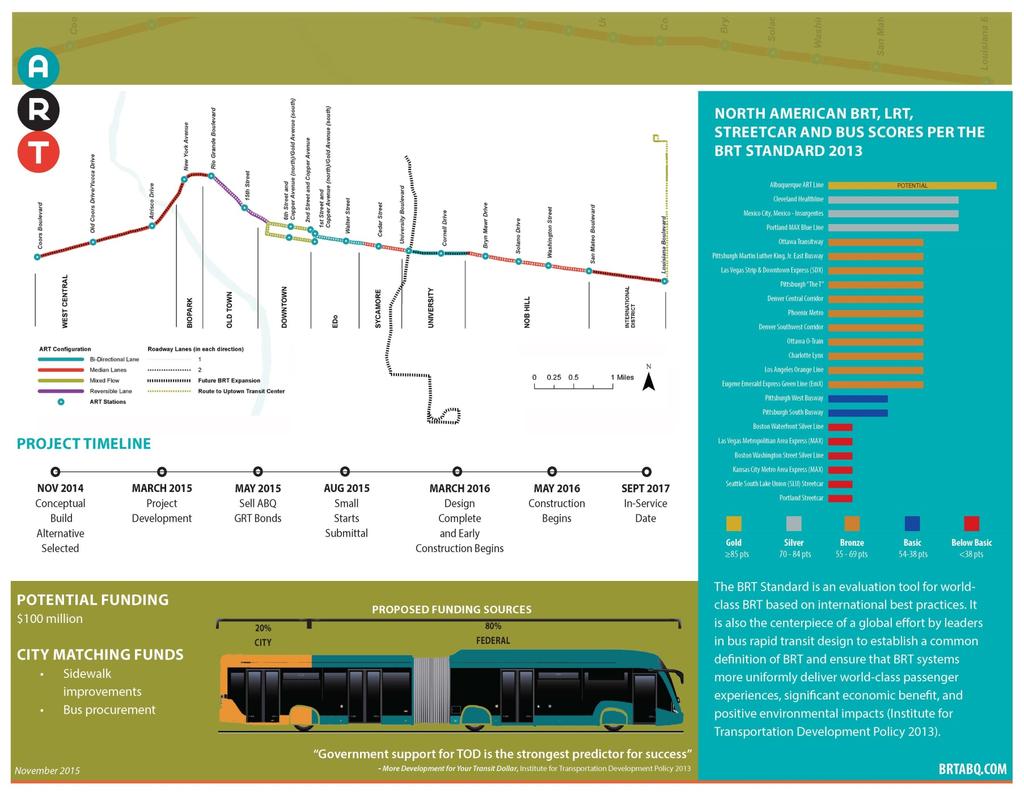
3 Project Status Schedule Service begins September
4 Major Accomplishments since March % ($24.5M of $25.5 M) in Local Funding is Committed NEPA Approval Small Starts Package Submitted Project Risk Assessment Conducted Task Start End Public Outreach On-going Project Development NEPA Preliminary Engineering Complete Complete Final Design May 2015 March 2016 FTA Small Starts Rating and Funding Small Starts Submittal Complete LONP Bus Procurement (Needed) January 2016 LONP Phase 1 Construction (Needed) February 2016 Small Starts Grant Agreement March 2016 Oct 2016 Local Funding Process Adapt of City bond Ordinance January 2015 May 2015 Finalize Other Non-Small Starts Funding January 2015 February 2016 Construction/Vehicles Bus Procurement Process October 2015 July 2017 CMAR Procurement August 2015 November 2016 Construction Phase 1 March 2016 July 2017 Construction Phase 2 May 2016 July 2017 Testing and Start Up July 2017 September 2017 Revenue Operations September

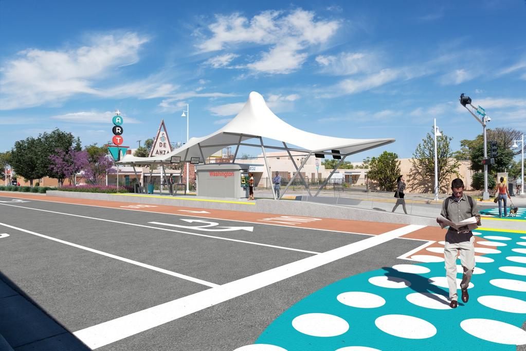
5 Three transit lines on Central serve increased ridership. 4
6 5
7 6
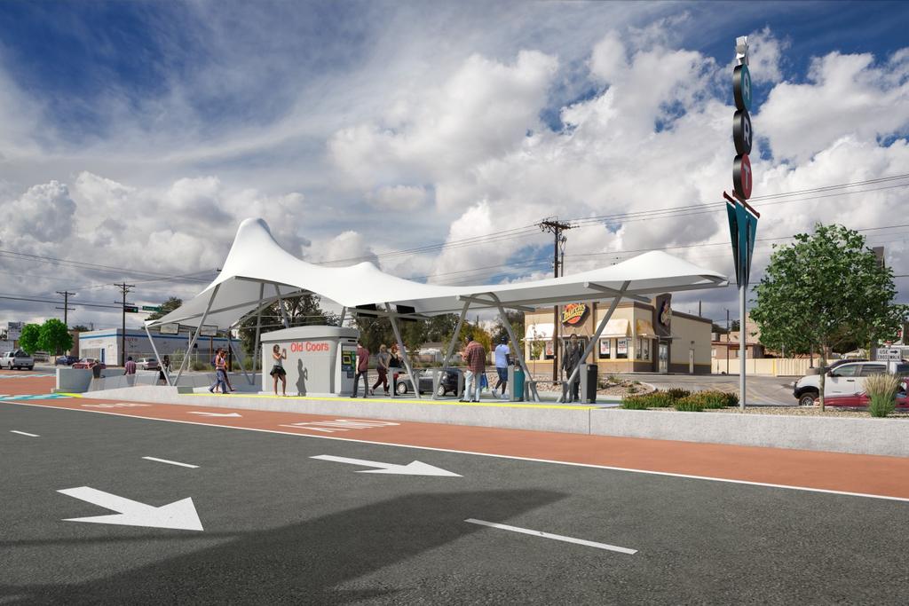
8 7
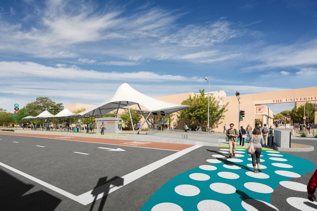
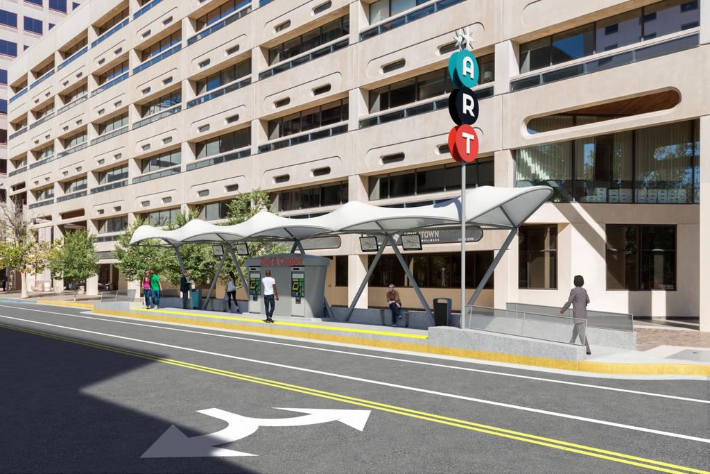
9 8
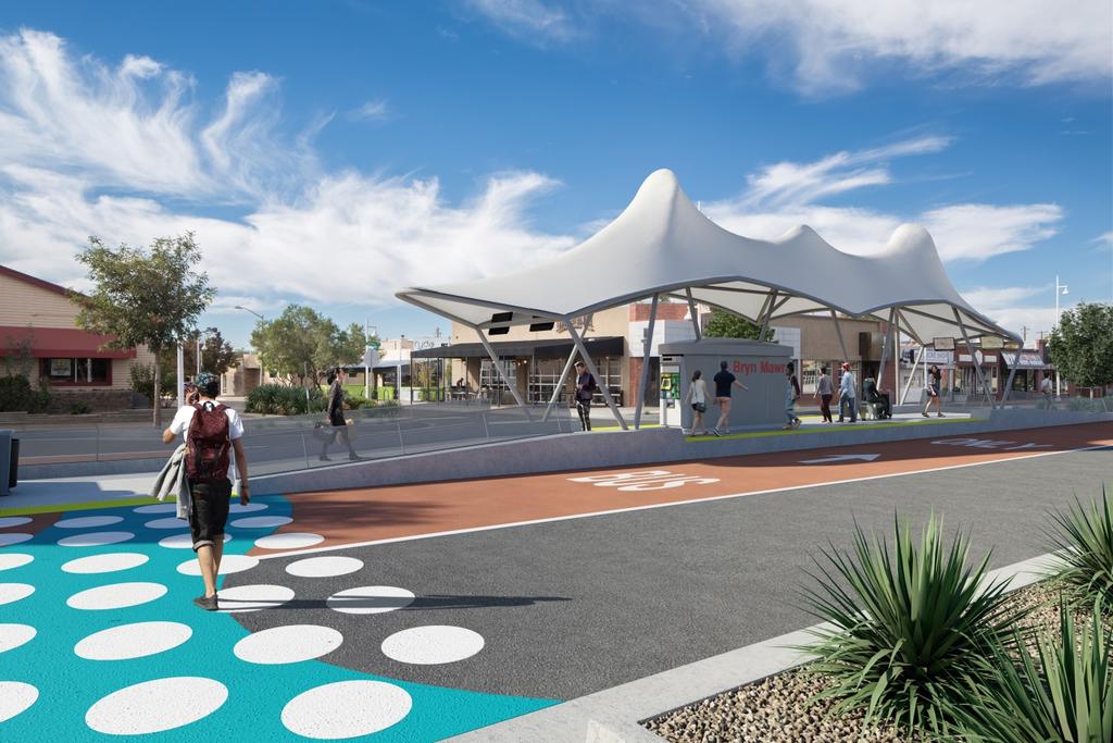
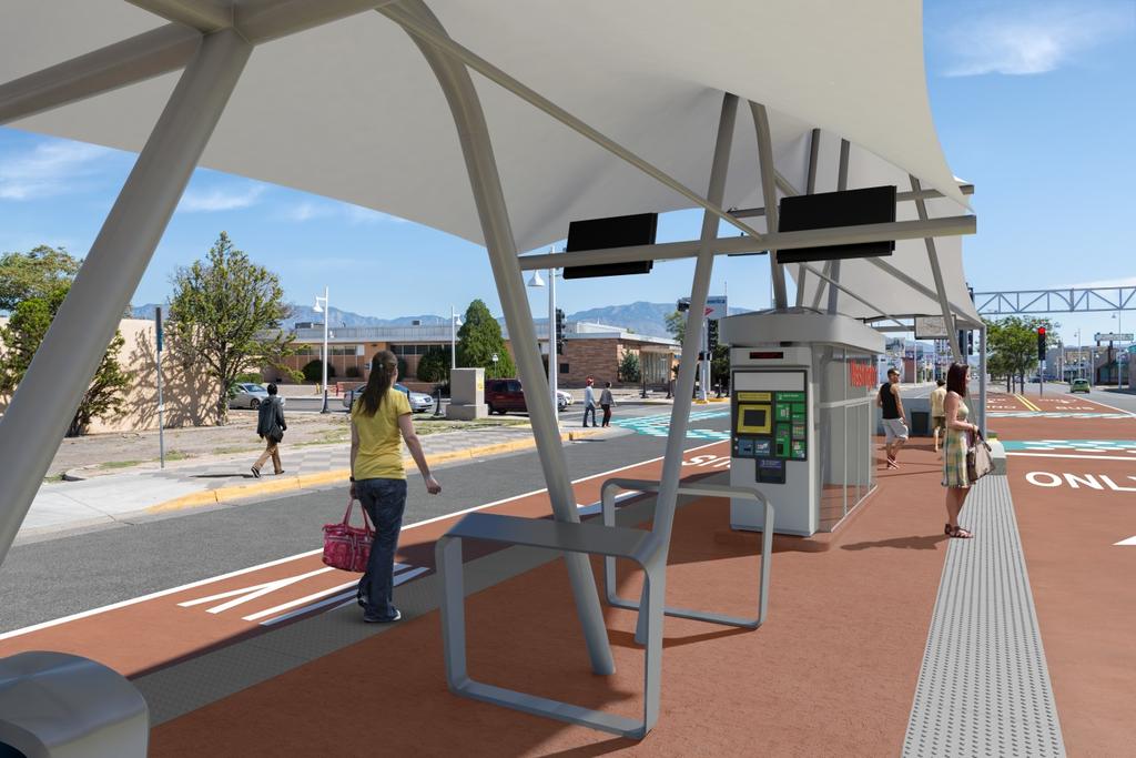
10 9
11 Public Outreach Response to Community Concerns One on One Meetings with Concerned Business Owners Friends of Transit Developing Business Outreach Program Center for neighborhood Technology Bloomberg Foundation Public Meetings Visioning session August 2015 o Six sessions to focus on station areas and opportunities Open houses Early 2016 o Review of construction process Business Outreach Program Assembling team for business outreach and support Letters to 956 businesses mailed October 9, 2015 In-person outreach to individual businesses begin October 22, 2015 o Surveys o Answering questions and discussing concerns 10

12 Letters of Support 11
13 12
14 13
15 14
16 Financial Plan Total Capital Cost (2015) $119,303,378 Total Capital Cost (YOE) $126,156,088 Section 5309 Small Starts Funding $69,023,577 Section 5309 Small Starts Share 54.7% Other Federal Funding Sources Type of Funds Dollar Amount (YOE) % of Total Capital Cost New or Existing Source Committed, Budgeted or Planned FTA Section 5309 Formula Funds $1,500, % Existing Committed FTA Section 5307 Formula Funds $8,139, % Existing Committed FTA Section 5307 Formula Funds $6,000, % Existing Budgeted FTA Section 5339 Formula Funds $3,204, % Existing Budgeted CMAQ Formula Funds $5,118, % Existing Committed CMAQ Formula Funds $7,650, % Existing Budgeted Sub-Total $31,612,111 Local Funding Sources Type of Funds Dollar Amount (YOE) % of Total Capital Cost New or Existing Source Committed, Budgeted or Planned Match to FTA 5309 funds General Funds $420, % Existing Committed Bernalillo County General Funds $1,000, % Existing Planned GO Bond Proceeds Bond Proceeds $13,000, % Existing Committed GO Bond Proceeds Bond Proceeds $4,100, % Existing Committed GO Bond Proceeds (Broadband) Bond Proceeds $1,000, % Existing Committed Transportation Infrastructure Tax Gross Receipts Tax Funds $6,000, % Existing Committed Sub-Total $25,520,400 Total Non-Section 5309 Funding $57,132, % 15


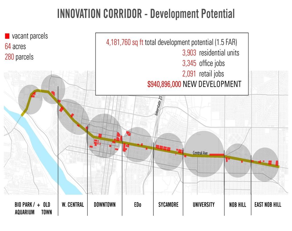
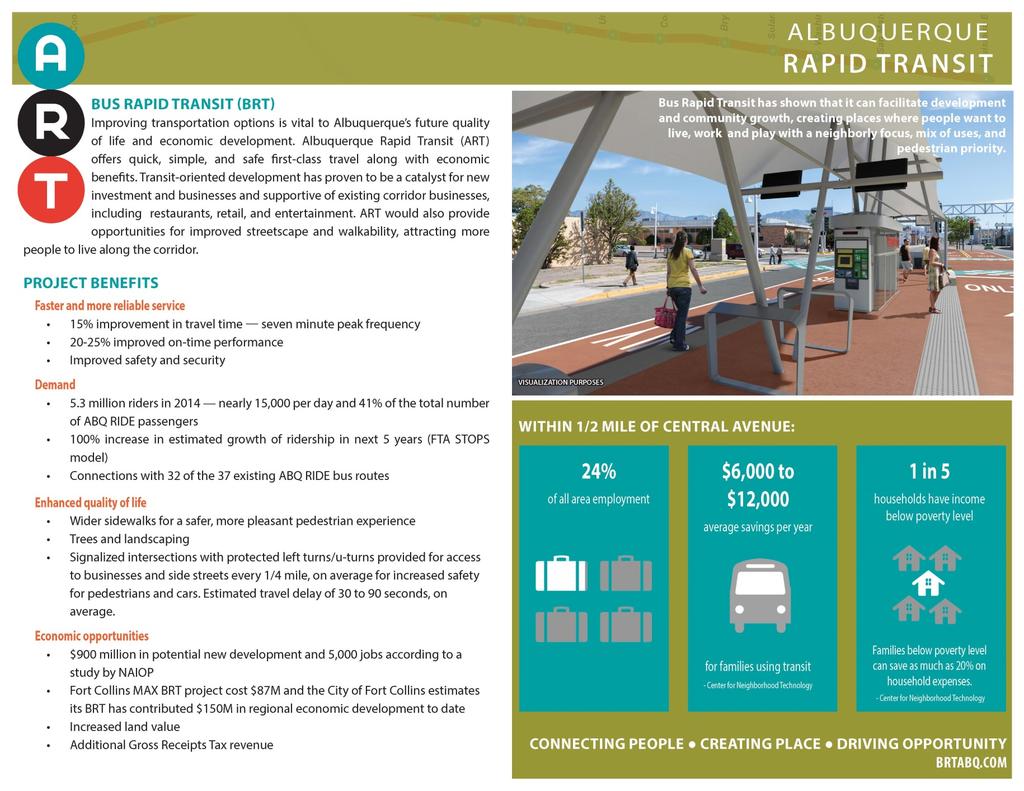
17 Transit Oriented Development Cleveland invested $250 million Investment return $5.8 billion in associated development Open 6 years Ft. Collins invested $ 87 million Investment return $150 million in associated development Open 1 year TOD Planning Grant 16
18 TOD Projections 17

19 Commercial Real Estate Estate Development Association, New Mexico 18
20 Center for Neighborhood Technology 19
21 Center for Neighborhood Technology 20


22 TOD Projects Station Area: UNM Presbyterian Hospital Mixed-Use Titan Development has conceptual plans for nearly five full blocks (approximately 10 acres) along Central Avenue, directly adjacent from the Presbyterian Hospital campus. Note the ART Station in the center of the interface. Titan is proposing a vertical mixture of multifamily, retail, and a hotel. The company is currently concluding discussions with neighborhood groups and expects to submit a master plan to the City s Environmental Planning Commission by the end of the year. Station Area: CBD Entertainment Hub Through a competitive bid process, a developer was chosen by the Metropolitan Redevelopment Agency to construct an Entertainment Hub on a 1.75-acre site in downtown, adjacent to the Alvarado Transportation Center and across the railroad tracks from Innovate ABQ. The site will incorporate the west-bound ART station directly at the corner of First and Central. The winning bid proposes a $38.5 million mixed-use project to include 39,000 square feet of entertainment (bowling alley, retail, brewery), 5,500 square feet of outdoor dining, and 76 apartments. 21


23 Station Area: CBD Innovate ABQ Located within the CBD, this 7-acre project is a publicprivate partnership intended to establish the headquarters of a STEMbased research district intended to leverage the region's scientific acumen in an effort to incubate job opportunities. Anticipated uses include laboratories, offices, retail, residential, hotels, and public open space. The project site was chosen to leverage the regional transit hub and network (including both east- and west-bound ART stations) available immediately west of the site at the Alvarado Transportation Center. The development team is in the due diligence phase and is proposing approximately 300 residential units, along with renovated office space as part of the first phase. The Master Plan shows the potential for over 500,000 square feet of development at full build-out. Station Area: Nob Hill The Carlisle Located in the heart of Albuquerque's Nob Hill, a private developer is constructing a vertical mixed-use development which will include 36 luxury residences, 2,000 square feet of retail on the ground level, and a 43-space underground parking structure, all on ½ acre of ground. The ART Station is two blocks east at Solano Street. Ground was broken in August The development will cost an estimated $8.2 million and is primarily targeted to Baby-Boomers. 22


24 Station Area: Old Town El Vado Motel Redevelopment The Metropolitan Development Agency has secured proposals for a $15.9 million repurposing of a former Route 66 motel, combined with some new construction, to include 30 workforce-housing units, 16,000 square feet of commercial and common space, an amphitheater, motel, and events center. Construction on the 2.7 acre site is anticipated to begin in Station Area: Nob Hill De Anza Motor Lodge Redevelopment This $8.2 million project proposes to redevelop a historically listed Route 66 motor lodge into mixed use, condominium project with a restaurant. The existing structure was built in 1919 and was a tourist stop for years. In 2003 the city purchased the 2-acre site after it had been vacant for some time. In mid-2015 the development team won approval by the Albuquerque Development Commission to re-develop the site and proposes to complete the redevelopment by the end of All of these projects are in active stages of development and evidence the characteristics of transit orientation by their placement on the Corridor, by their orientation to the Corridor, and by their proximity to an ART station. Save for the El Vado and De Anza redevelopment projects, both of which involve historically listed structures they are vertical mixed-use transit-oriented developments. 23
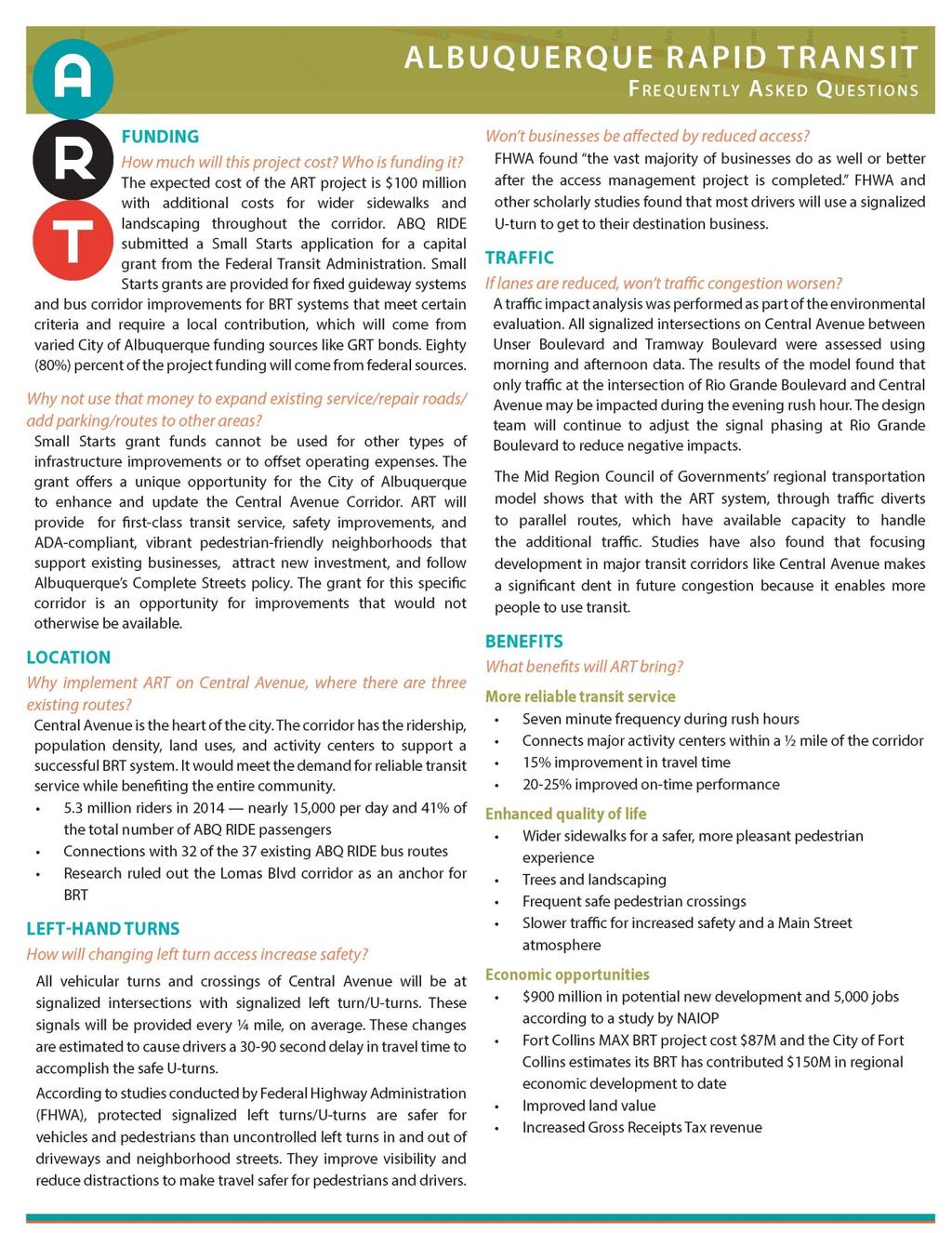
25 Frequently Asked Questions Q: What s this all about anyway? Answer: Albuquerque Rapid Transit (ART) is planning to implement a new form of transit that combines many features of rail transit with the flexibility of buses. ART, at 1/3rd the cost of rail, is the most cost-effective technology for the City of Albuquerque s current population and future ridership estimates. Some key elements of ART include: Dedicated road, lane or mixed traffic route Frequent service (every 7.5 minutes) Prioritized signaling at intersections Pre-boarding ticketing Level boarding raised-platform stations The goal of Albuquerque Rapid Transit is to provide quick and efficient bus service with increased dependability and timeliness. The level boarding platforms mean that wheelchairs, walkers, and bicycles can just roll on board; no time-consuming racks or ramps. Combined with off-board fare purchases, ART can reduce the time the bus stands still to pick up passengers, which will greatly improve service speed. This, combined with advanced signal timing and a dedicated lane allows the ART to move more easily through city traffic, with much greater dependability than Rapid Ride. Q: Where will it go? A: ART will run a 9 mile route in dedicated lanes serving 20 stations from Louisiana on the east to Coors on the west. Just as the Rapid Ride does, ART service will extend in undedicated lanes from Louisiana to Tramway and Uptown, and from Coors to the Central and Unser Transit Center. Q: What s the difference between this and bus service we already have? A: There are two, current Rapid Rides run along Central in the existing traffic flow. They utilize stations spread from one to two miles apart. When traffic stacks up at key points during certain times of the day, the Rapid Rides tend to stack up with it, too. ART would be a timelier service, utilizing a mix of dedicated lanes, bi-directional lanes, and reversible lanes. It will run by each station every 7 ½ minutes as intended, without being stuck in regular traffic. Q: Who s paying for it and where is the money coming from? A: The vast majority of the money for this project (80%) is coming from the Federal Transit Administration s (FTA) Small Starts Capital Grant Program. Earlier this year, 24
26 City Council also agreed to issue $13 million dollars of gross receipts tax revenue bonds for this project. The remaining money will come from different sources. Q: Why are we doing this? A: Two main things. The city wants to improve the timely nature of service down Central Avenue, ABQ RIDE s most-used corridor (roughly 42% of all ridership on ABQ RIDE is concentrated on Central). Secondly, the city wants to take advantage of the opportunities for development that occur when a transportation system goes into a main corridor. As has happened with so many other cities, business development occurs along areas where many people are concentrated. Q: How do we know it will do what s claimed? While no one can foretell the future, other cities such as Ft. Collins, Cleveland and Phoenix have done it. They have all experienced a positive return on their investment in a transit system; anywhere from four to $150 dollars on every dollar spent, and in all cases property values along the line have gone up. There is much supporting documentation on our project website at brtabq.com. Q: Has anyone done any research for this project? A: Consideration of a replacement for the Rapid Ride began when City Council adopted R , instructing us to consider Central as the priority corridor for a high-capacity transit project. The Rapid Transit Project Alternatives Analysis was received by the City Council in The Rapid Rides themselves were instituted in 2004 and 2009 on the basis of that report, both to meet growing demand and as a means of testing the market on Central. They have been very successful. So, the first feasibility study specific to BRT was conducted in fall of Since then, we have examined just about every system in the United States; researched FTA documents, investigated information from the National Bus Rapid Transit Research Institute, and the Institute for Transportation Development Policy among many others, to determine what works and why. Many research documents can be found on the website. Q: Won t this add to congestion? A: A traffic-impact analysis was performed as part of the environmental evaluation. The impact to each signalized intersection on Central Avenue between Unser Boulevard and Louisiana Boulevard was assessed using actual traffic counts from morning and afternoon rush hours. The results of the analysis found that all of the intersections would continue to operate in accordance with City of Albuquerque standards. In addition to the intersection-level analysis prepared for the project, the Mid Region Council of Governments (MRCOG) analyzed potential impacts to parallel routes and found that while some through-traffic shifts to parallel routes, those routes have available capacity to handle the additional traffic and meet the City s standards. Nationally, studies have also found that focusing development in major transit corridors like Central Avenue makes a significant dent in future congestion because 25
27 it enables more people to use transit or other modes of transportation, including walking. Q: Won t existing businesses lose ease of access to their properties? A: Some left turn access will go away, in favor of legalized, signalized U-turns. The Federal Highway Administration (FHWA) and others have studied the impacts of similar projects on businesses and safety. FHWA found the vast majority of businesses do as well or better after the access management project is completed. FHWA and other scholarly studies found that most drivers will use a signalized U- turn to get to their destination business. Q: Is there an opportunity to discuss all this in greater detail? A: Our public input is ongoing. The next round of public input sessions are likely scheduled for next year. Dates and places will be posted on the project website as well as in this newsletter Q. Why not use the money from the grant ABQ RIDE is applying to the Federal Government for ART to expand existing service/repair roads/ add parking/add routes to other areas? A. Small Starts grant funds cannot be used for other types of infrastructure improvements nor to offset operating expenses. The grant offers a unique opportunity for the City of Albuquerque to enhance and update the Central Avenue Corridor, providing first class transit service, safety improvements, ADA-compliant, vibrant pedestrian-friendly neighborhoods that support existing businesses and attract new investment while following Albuquerque s Complete Streets policy. The grant for this specific corridor is an opportunity for improvements that would not otherwise be available. Q. Why implement ART on Central Avenue, where there are already three routes? Central Avenue is the heart of the city. The corridor has the ridership, population density, land uses, and activity centers to support a successful BRT system. It would meet the demand for reliable transit service while benefiting the entire community. The Rapid Ride introduced in 2004 is at capacity. ART is the next logical step in modern transportation service. 5.3 million riders in 2014 nearly 15,000 per day and 41% of the total number of ABQ RIDE passengers Connections with 32 of the 37 existing ABQ RIDE bus routes Feasibility study ruled out the Lomas Blvd corridor as an anchor for BRT transportation must be where people want to go. 26
28 Q. How will changing left turn access increase safety? All vehicular turns and crossings of Central Avenue will be at signalized intersections with signalized left turn/u-turns. These signals will be provided every ¼ mile, on average. These changes are estimated to cause drivers a second delay in travel time to accomplish the safe U-turns. According to studies conducted by Federal Highway Administration (FHWA), signalized left turns/u-turns are safer for vehicles and pedestrians than uncontrolled left turns in and out of driveways and neighborhood streets. They improve visibility and reduce distractions to make travel safer for pedestrians and drivers. Q. What does it cost to run ABQ RIDE? A. Cost of operating fixed route buses and their associated maintenance is $29.3. ABQ RIDE general fund subsidy is $21.6 Q. What will it cost to run ART? A. An increase of about 4% with the current operating plan. Q: What will hours of service be for Albuquerque Rapid Transit? A: For now, the hours of service for ART will match the current hours of service for the Rapid Rides down Central; from approximately 5:30 a.m. to 9:45 p.m. The hours for ART could also be expanded later during summer, much as Route #66 operates 66 Late Night during the summer. Q: Why can t it run until 1 am year round? A: Currently, it is a matter of money. But one of ART s goals for the future is to expand service. Q: Will there be access to Central Ave. businesses during construction? A: Yes. One lane will be open in each direction at all times in front of businesses. We will also be working with business to make sure people know they are open and accepting customers. Q: Why do we think this will help Central? A: ART will not only improve the timely nature of transit service on Central Avenue, it will also upgrade the appearance and condition of Central. The project will add lighting, improve sidewalk conditions, add sidewalk landscaping, and improve pedestrian safety, all of which supports the furtherance of economic opportunity along this corridor. Q: Why do I care, if I live in an area such as the Northeast Heights? A: A project like ART, by motivating development along Central, would help grow the overall economy in the city. And when the economy improves, all areas of the city benefit. Also, the majority of ABQ RIDE s bus routes connect to the Central Ave routes. ART could help improve the timeliness of those routes as well. 27
29 Q: Why is this project being promoted as a key element of bolstering the underperforming economy of Albuquerque? A: Rapid transit projects like ART have a proven record of stimulating development and redevelopment of neighborhoods in other cities. For instance, an article in Albuquerque Business First said during the first year that Fort Collins, CO operated its rapid transit system, it attracted $150 million in associated development along its transit corridor. A Forbes magazine article said Cleveland s $250 million investment in putting its HealthLine down a main corridor has generated $5.8 billion in development since opening in That s $114 for each transit dollar invested. Q: Why Central Ave? It goes through historic districts, fledgling business districts and some of the only pedestrian friendly areas outside planned malls in all of Albuquerque? A: It is for exactly those reasons that Albuquerque Rapid Transit will be operating on Central Ave. from Coors to Louisiana. Transit systems have been described as moving sidewalks. They transport people to locations where they can get off and shop, do business or have a meal. People can get right back on and do more of the same or go home. ART will also upgrade the look and feel of Central Ave by adding to the walkability and livability of neighborhoods. Plans include widening sidewalks and adding trees to encourage pedestrian and bike-friendly development. Signalized crosswalks will also improve the safety of those walking or biking in the neighborhoods, as well as improved street lighting. Central also connects some of Albuquerque s main institutions; University of New Mexico, Presbyterian Hospital. With the help of Innovate ABQ, ART could stimulate a tremendous economic revitalization and development of the corridor. Q: I have read the ABQ NAIOP study, reports from the FTA and other sources, but still cannot find evidence of how ART will promote economic growth. Yes, there is real evidence of real estate development along corridors where these buses travel, but real estate development is being confused with economic growth. Why is this? A: The NAIOP study, for instance, says that development along the ART route could create several thousand new residences and importantly several thousand new jobs. The creation of jobs is the very definition of economic development. Organizations like LAVU, Molina, Fat Pipe, and Innovate ABQ could go anywhere in the City they wanted. They chose the Central Corridor. 28
30 Q: Route 66 is sparsely populated, from east to west. A number of Albuquerque s largest employers are situated on this corridor; the City/County, UNM, two hospitals and Sandia Labs/Kirtland Base. My question is how many of their employees actually live along Central? It seems to me that ART would be worth the investment only if we had an enormous population that needed to move along this corridor from end to end. Isn t this true? A: One-mile wide and ten miles long, the Corridor contains about 5% of the area of the City of Albuquerque but is home to 15% of all households and 23% of all jobs in the City. The three routes on Central carry 42% of all transit ridership on the system and connect to 32 routes that crisscross the City. The Central Corridor is a busy place. Q: Lomas Boulevard, runs parallel to Central/Route 66 and also services all of the same employers. The difference is Lomas has always been a service street, from west of Downtown to Tramway. Lomas is low on character, has very little charm, almost no residential. If we must build the ART, why wouldn t Lomas be the best street to use? A: Lomas doesn t serve important locations like the International District, Nob Hill, and Presbyterian Hospital, and does not perform the vital chore of crossing the Rio Grande. Compared to Central (using the same one-mile corridor approach) it has 20% fewer jobs and only half the number of households. Transit is supposed to connect people to places. Central is the much stronger Corridor. Q: The proposed plans for Central Avenue tell me this project will not enhance the charm of the street but rather degrade its historic and charming value. At the least, in areas where the streets are narrow and charming, it will clog up the streets and slow traffic. Why would the city authorize and promote this? A: The ART project will contribute and in some areas enhance the character of Central Avenue. Widening sidewalks, removing sidewalk ADA deficiencies, adding sidewalk landscaping, and improving pedestrian lighting create a walkable environment. This type of environment attracts people and businesses. Many areas along Central Avenue want slower traffic. This increases the safety of pedestrian and bicycle users and makes businesses more visible. 29
31 30
32 31
33 32
Project Narrative. Albuquerque, NM. July 31, 2015
 Project Narrative Albuquerque, NM July 31, 2015 1 Project Identification As the first bus rapid transit (BRT) project in New Mexico, the Albuquerque Rapid Transit (ART) line will run through the heart
Bus Rapid Transit Plans
 Twin Cities Region Bus Rapid Transit Plans ULI Minnesota Workshop Connecting Bus Rapid Transit to the Community December 15, 2009 John Levin Director of Service Development Metro Transit Metropolitan Area
MEETING Agenda. Introductions. Project Overview. Key Study Components. Alternative Station Concepts. Preferred Station Concept. Next Steps.
 City GARLAND Council ROADVISION Briefing STUDY VISION STUDY Dallas, TX April 8, 2010 1 1 MEETING Agenda Introductions Project Overview Key Study Components Alternative Station Concepts Preferred Station
Old Town Meeting
 Old Town Meeting 3.1.16 Question: Project Schedule When will the actual construction take place in the Old Town area? Parking and Driving Routes How will you manage rush hour traffic to and from downtown?
Afeasibility study to evaluate bus rapid transit service in the East-West Corridor connecting major employment and activity centers between downtown
 East-West Bus Rapid Transit Feasibility Study Update and Recommended Locally Preferred Alternative (LPA) Summary City of Wauwatosa, Transportation Affairs Committee June 2016 Afeasibility study to evaluate
Executive Summary Route 30 Corridor Master Plan
 Route Corridor Master Plan Project Overview The Route Corridor Master Plan is a coordinated multimodal transportation and land use plan for the entire stretch of Route through East Whiteland Township,
David Jickling, Public Transportation Director Regional Transportation Commission, Washoe County
 David Jickling, Public Transportation Director Regional Transportation Commission, Washoe County Virginia Street Resort corridor connecting University of Nevada, Reno Downtown Truckee River Strip Casinos
In station areas, new pedestrian links can increase network connectivity and provide direct access to stations.
 The Last Mile Planning for Pedestrians Planning around stations will put pedestrians first. Making walking to stations safe and easy is important; walking will be a part of every rapid transit Accessible
DALLAS MIDTOWN REDEVELOPMENT PLAN FOCUS NORTH TEXAS Peer Chacko, AICP, Assistant Director, City of Dallas
 DALLAS MIDTOWN REDEVELOPMENT PLAN FOCUS NORTH TEXAS 2014 Peer Chacko, AICP, Assistant Director, City of Dallas Dallas Midtown: Strategic growth area Future transit node 2 Peterson Road Study Area Galleria
Capital and Strategic Planning Committee. Item III - B. April 12, WMATA s Transit-Oriented Development Objectives
 Capital and Strategic Planning Committee Item III - B April 12, 2018 WMATA s Transit-Oriented Development Objectives Page 24 of 76 Washington Metropolitan Area Transit Authority Board Action/Information
Bus Rapid Transit ALTERNATIVES ANALYSIS. Open House
 Bus Rapid Transit ALTERNATIVES ANALYSIS Open House June 23, 2015 Open House Meeting Agenda Agenda Introductions What is BRT? Project Goals Study Tasks Next steps Discussion PVTA Bus Rapid Transit Study
A Selection Approach for BRT Parking Lots Nicolls Road Corridor Parking Study
 A Selection Approach for BRT Parking Lots Nicolls Road Corridor Parking Study Chirantan Kansara, P.E. Engineering Construction Design Planning 2018 ITE Northeastern District Annual Meeting Lake George,
Arterial Transitway Corridors Study. Ave
 Arterial Transitway Corridors Study Ave January 2012 Arterial Transitway Corridors Study Overview Corridor Features and Demographics 11 study corridors, 95 route miles 86,000 daily rides and half of existing
Technical Working Group November 15, 2017
 Technical Working Group November 15, 2017 Welcome and Introductions Project Partners Regional Transportation District (RTD) Colorado Department of Transportation (CDOT) Denver Regional Council of Governments
PEDESTRIAN ACTION PLAN
 ATTACHMENT 2 CITY OF SANTA MONICA PEDESTRIAN ACTION PLAN CITY OF SANTA MONICA PEDESTRIAN ACTION PLAN This page intentionally left blank EXECUTIVE SUMMARY CHAPTER 1 EXECUTIVE SUMMARY Setting the Stage
7/23/2017 VIA . Michael Hanebutt City of Sacramento Community Development Department 300 Richards Boulevard, 3 rd Floor Sacramento, CA 95811
 7/23/2017 VIA EMAIL Michael Hanebutt City of Sacramento Community Development Department 300 Richards Boulevard, 3 rd Floor Sacramento, CA 95811 RE: 65 th Street Apartments (DR17-220) Dear Mr. Hanebutt:
Corpus Christi Metropolitan Transportation Plan Fiscal Year Introduction:
 Introduction: The Safe, Accountable, Flexible, Efficient Transportation Equity Act: A Legacy for Users (SAFETEA-LU) has continued the efforts started through the Intermodal Surface Transportation Efficiency
Broward Boulevard Gateway Implementation Project, Downtown Walkability Analysis, & Joint Development Initiative (JDI)
") Broward Boulevard Gateway Implementation Project, Downtown Walkability Analysis, & Joint Development Initiative (JDI) City of Fort Lauderdale ~ Commission Conference July 10, 2012 Page 1 of 15 A Multi-Agency
Broward Boulevard Gateway Implementation Project, Downtown Walkability Analysis, & Joint Development Initiative (JDI) City of Fort Lauderdale ~ Commission Conference July 10, 2012 Page 1 of 15 A Multi-Agency
Proposed. City of Grand Junction Complete Streets Policy. Exhibit 10
 Proposed City of Grand Junction Complete Streets Policy Exhibit 10 1 City of Grand Junction Complete Streets Policy Vision: The Complete Streets Vision is to develop a safe, efficient, and reliable travel
Transportation Master Plan Advisory Task Force
 Transportation Master Plan Advisory Task Force Network Alternatives & Phasing Strategy February 2016 BACKGROUND Table of Contents BACKGROUND Purpose & Introduction 2 Linking the TMP to Key Council Approved
Corridor Vision Workshop Summary James Madison Elementary February 22,2018
 Corridor Vision Workshop Summary James Madison Elementary February 22,2018 WHY DEVELOP THIS STUDY? Ogden City is planning for better connectivity and access to jobs and housing. Working with area partners,
Cherry Creek Transportation and Land Use Forum September 25, 2013 Meeting Summary
 Cherry Creek Transportation and Land Use Forum September 25, 2013 Meeting Summary I. LEAD-IN TO SMALL GROUP DISCUSSION, POLLING AND STEERING COMMITTEE/TECHNICAL TASK FORCE DISCUSSION The meeting began
Community Task Force November 15, 2017
 Community Task Force November 15, 2017 Welcome and Introductions Project Partners Regional Transportation District (RTD) Colorado Department of Transportation (CDOT) Denver Regional Council of Governments
Community Task Force March 14, 2018
 Community Task Force March 14, 2018 Welcome and Introductions Project Partners Regional Transportation District (RTD) City of Aurora Colorado Department of Transportation (CDOT) Denver Regional Council
Environment and Public Works Committee Presentation
 Mixed Use Centers Complete Streets Guidelines Project Environment and Public Works Committee Presentation December 10, 2008 Project Objectives: Conduct an inter-departmental and agency process to study
Perryville TOD and Greenway Plan
 Perryville TOD and Greenway Plan Greenway Glossary Pathway: A bicycle and pedestrian path separated from motorized vehicular traffic by an open space, barrier or curb. Multi-use paths may be within the
City of Atlanta-MARTA Sales Tax Referendum Draft Project List. Atlanta City Council Work Session May 19, 2016
 1 City of Atlanta-MARTA Sales Tax Referendum Draft Project List Atlanta City Council Work Session May 19, 2016 2 SB 369 - MARTA Sales tax for up to 0.50% is allowed in the City of Atlanta for MARTA Purpose
New Seward and 36 th Avenue Intersection Conceptual Design
 University of Alaska Anchorage New Seward and 36 th Avenue Intersection Conceptual Design Prepared By: Zaid S. Hussein Dana Menendez Galen Jones Civil Engineering Department Prof. Osama Abaza CE A404 Highway
Planning Regionally With Transit
 Planning Regionally With Transit Nathan Coats Director of Operations CTAA Expo 2015 Tampa Began 1992. Serves eastern Cache County to Preston, ID. Population- 115,000 34 bus fleet, 26 fixed route buses;
Speed Limits Study and Proposal. Public Input Session: 8/14/13
 Speed Limits Study and Proposal Public Input Session: 8/14/13 Why is Decatur a unique place for this project? First Community Transportation Plan in the nation with a Health Impact Assessment. Strong sense
City of Davenport CitiBus Public Transportation Study. April 2015
 City of Davenport CitiBus Public Transportation Study April 2015 Overview Project Background Key Findings CitiBus Service Allocation Policy Discussion 2 Project Background 3 About CitiBus Operates 17 routes
Metropolitan Council Transportation Committee
 Nicollet-Central Transit Alternatives Metropolitan Council Transportation Committee August 2013 Project Purpose (approved by Policy Advisory Committee 10/25/2012) The purpose is to improve transit connectivity,
5/7/2013 VIA . RE: University Village Safeway Expansion (P13-019)
") 5/7/2013 VIA EMAIL David Hung, Associate Planner Community Development Department, Current Planning Division City of Sacramento 300 Richards Boulevard, 3 rd Floor Sacramento, CA 95811 RE: University Village
5/7/2013 VIA EMAIL David Hung, Associate Planner Community Development Department, Current Planning Division City of Sacramento 300 Richards Boulevard, 3 rd Floor Sacramento, CA 95811 RE: University Village
Transportation in Washoe County. Lee Gibson, Executive Director February 15, 2011
 Transportation in Washoe County Lee Gibson, Executive Director February 15, 2011 RTC OF WASHOE COUNTY Metropolitan Planning Organization Meet long term needs Deliver federal funding Program projects in
Non-Motorized Transportation 7-1
 Non-Motorized Transportation 7-1 Transportation facilities no longer mean just accommodating a vehicle powered by a combustion engine. Pedestrian and non-motorized facilities are important modes of travel
Purpose and Need. Chapter Introduction. 2.2 Project Purpose and Need Project Purpose Project Need
 Chapter 2 Purpose and Need 2.1 Introduction The El Camino Real Bus Rapid Transit (BRT) Project (Project) would make transit and other transportation improvements along a 17.6-mile segment of the El Camino
San Jose Transportation Policy
 San Jose Transportation Policy Protected Intersections in LOS Policies to Support Smart Growth Presented by: Manuel Pineda City of San Jose Department of Transportation Bay Area Map San Francisco Oakland
Frequently Asked Questions (FAQ)
") Frequently Asked s (FAQ) Study Process... 2 Rapid Transit Service and Operations... 5 Public Consultation... 8 Business Impacts... 8 Design and Property Impacts... 9 Construction Impacts...12 Traffic,
Frequently Asked s (FAQ) Study Process... 2 Rapid Transit Service and Operations... 5 Public Consultation... 8 Business Impacts... 8 Design and Property Impacts... 9 Construction Impacts...12 Traffic,
CHAPTER 7.0 IMPLEMENTATION
 CHAPTER 7.0 IMPLEMENTATION Achieving the vision of the Better Streets Plan will rely on the ability to effectively fund, build and maintain improvements, and to sustain improvements over time. CHAPTER
Community Task Force July 25, 2017
 Community Task Force July 25, 2017 Welcome and Introductions Project Partners Regional Transportation District (RTD) Colorado Department of Transportation (CDOT) Denver Regional Council of Governments
Southwest Bus Rapid Transit (SW BRT) Functional Planning Study - Executive Summary January 19 LPT ATTACHMENT 2.
 Functional Planning Study - Executive Summary January 19 LPT ATTACHMENT 2.") Southwest Bus Rapid Transit (SW BRT) Functional Planning Study - Executive Summary 2011 January 19 1 of 19 Introduction This executive summary presents the results of the Southwest Bus Rapid Transit (SW
Southwest Bus Rapid Transit (SW BRT) Functional Planning Study - Executive Summary 2011 January 19 1 of 19 Introduction This executive summary presents the results of the Southwest Bus Rapid Transit (SW
North Shore Transportation Improvement Strategy
 North Shore Transportation Improvement Strategy Preliminary, Near-term Recommendation 2016 April Transportation Improvement Strategy (TIS) Comprehensive and Analytical A multi-modal transportation strategy
May 12, 2016 Metro Potential Ballot Measure Issue Brief: Local Return
 Summary: Local return is an important revenue source for cities to maintain their local transportation infrastructure. Most cities use their local return to operate small bus systems and repave streets,
Capital Improvement Project Application: Bike Racks, Bus Stop Shelters, Sidewalks in Kings Canyon/Ventura Corridor Page 1 of 10
 Bike Racks, Bus Stop Shelters, Sidewalks in Kings Canyon/Ventura Corridor Page 1 of 10 Project Summary 1. Project Title: Bike Racks, Bus Stop Shelters, Sidewalks in Kings Canyon/Ventura Corridor 2. Project
Appendix A-1: Purpose and Need Statement
 Appendix A-1: Purpose and Need Statement PURPOSE AND NEED STATEMENT Western & Ashland Corridors Bus Rapid Transit (BRT) Project Prepared for Chicago Transit Authority 567 West Lake Street Chicago, IL 60661
CITY OF BLOOMINGTON COMPLETE STREETS POLICY
 CITY OF BLOOMINGTON COMPLETE STREETS POLICY POLICY OBJECTIVE: The City of Bloomington will enhance safety, mobility, accessibility and convenience for transportation network users of all ages and abilities,
5/31/2016 VIA . Arwen Wacht City of Sacramento Community Development Department 300 Richards Blvd., 3 rd Floor Sacramento, CA 95811
 5/31/2016 VIA EMAIL Arwen Wacht City of Sacramento Community Development Department 300 Richards Blvd., 3 rd Floor Sacramento, CA 95811 RE: El Pollo Loco (P16-028) Dear Ms. Wacht: WALKSacramento has reviewed
CITY OF COCOA BEACH 2025 COMPREHENSIVE PLAN. Section VIII Mobility Element Goals, Objectives, and Policies
 CITY OF COCOA BEACH 2025 COMPREHENSIVE PLAN Section VIII Mobility Element Goals, Objectives, and Policies Adopted August 6, 2015 by Ordinance No. 1591 VIII MOBILITY ELEMENT Table of Contents Page Number
ACTIVE TRANSPORTATION
 ACTIVE TRANSPORTATION Mobility 2040 Supported Goals Improve the availability of transportation options for people and goods. Support travel efficiency measures and system enhancements targeted at congestion
Better Market Street. Engineering, Maintenance & Safety Committee (EMSC) February 28, 2018
 February 28, 2018") Better Market Street Engineering, Maintenance & Safety Committee (EMSC) February 28, 2018 1 Market Street Market Street - San Francisco by rulenumberone2 2 Market Street is the... City s busiest pedestrian
Better Market Street Engineering, Maintenance & Safety Committee (EMSC) February 28, 2018 1 Market Street Market Street - San Francisco by rulenumberone2 2 Market Street is the... City s busiest pedestrian
BUILDING THE CASE FOR TRAVEL OPTIONS IN WASHING TON COUNTY. Image: Steve Morgan. Image: Steve Morgan
 BUILDING THE CASE FOR TRAVEL OPTIONS IN WASHING TON COUNTY Image: Steve Morgan Image: Steve Morgan Image: TriMet Image: TriMet WHAT ARE TRAVEL OPTIONS PROGRAMS? Travel options programs encourage residents,
TRANSIT & NON-MOTORIZED PLAN DRAFT FINAL REPORT Butte County Association of Governments
 1 INTRODUCTION Maintaining a high quality of life is the essence of this plan for transit and non-motorized transportation in Butte County. Curbing greenhouse gas emissions (GHG) by reducing congestion,
Appendix A-K Public Information Centre 2 Materials
 Appendix A-K Public Information Centre 2 Materials Our Rapid Transit Initiative Make an impact on the future of transit Join the discussion on Rapid Transit in London You re invited to a Public Information
Spring Lake Park Mounds View North Oaks. Arden Hills. Shoreview. Roseville. Little Canada. Falcon Heights SNELLING. Lilydale. West Saint Paul 35E
 Coon Rapids Blaine Spring Lake Park Mounds View rth Oaks In 2011, Metro Transit embarked on the Arterial 494 Minnetonka Maple Grove Plymouth Hopkins Brooklyn Park New Hope Golden Valley Louis Park Edina
6/22/2018 VIA . Darcy Goulart, Planning Manager City of Rancho Cordova Planning Department 2729 Prospect Park Drive Rancho Cordova, CA 95670
 6/22/2018 VIA EMAIL Darcy Goulart, Planning Manager City of Rancho Cordova Planning Department 2729 Prospect Park Drive Rancho Cordova, CA 95670 RE: Quick Quack Car Wash (DD9801) Dear Ms. Goulart: WALKSacramento
INNER LOOP EAST. AIA Rochester Annual Meeting November 13, 2013 TRANSFORMATION PROJECT. Bret Garwood, NBD Erik Frisch, DES
 INNER LOOP EAST TRANSFORMATION PROJECT AIA Rochester Annual Meeting November 13, 2013 Bret Garwood, NBD Erik Frisch, DES Why? We are building a city that encourages walking, biking and enjoying the outdoor
NEWMARKET UPHAM S CORNER
 SOUTH STATION Planning Initiative NEWMARKET UPHAM S CORNER COLUMBIA ROAD (P) FOUR CORNERS/GENEVA Working Advisory Group (WAG) Meeting #5 TALBOT AVENUE MORTON STREET BLUE HILL AVE/CUMMINS HWY (P) RIVER
Tonight is for you. Learn everything you can. Share all your ideas.
 Strathcona Neighbourhood Renewal Draft Concept Design Tonight is for you. Learn everything you can. Share all your ideas. What is Neighbourhood Renewal? Creating a design with you for your neighbourhood.
12/4/2016 VIA . RE: Grocery Outlet Del Paso (DR16-328)
") 12/4/2016 VIA EMAIL Ethan Meltzer, Assistant Planner City of Sacramento Community Development Department 300 Richards Blvd, 3 rd Floor Sacramento, CA 95811 RE: Grocery Outlet Del Paso (DR16-328) Dear Mr.
12/4/2016 VIA EMAIL Ethan Meltzer, Assistant Planner City of Sacramento Community Development Department 300 Richards Blvd, 3 rd Floor Sacramento, CA 95811 RE: Grocery Outlet Del Paso (DR16-328) Dear Mr.
Bikeway action plan. Bicycle Friendly Community Workshop March 5, 2007 Rochester, MN
 Bikeway action plan Summary The was held on March 5, 2007 at the Rochester Mayo Civic Center. The workshop was hosted by Rochester-Olmsted County Planning Department in collaboration with the League of
STONY PLAIN ROAD STREETSCAPE
 Jasper Place Revitalization Strategy: Vision The people involved in the Jasper Place Revitalization Strategy envision: Goal 1: Feeling safe in our community Create a community where feeling safe is common--where
4 Ridership Growth Study
 Clause 4 in Report No. 15 of Committee of the Whole was adopted, without amendment, by the Council of The Regional Municipality of York at its meeting held on November 16, 2017. 4 Ridership Growth Study
6/14/2013 VIA . Evan Compton, Associate Planner Community Development Department City of Sacramento 300 Richards Blvd Sacramento, CA 95814
 6/14/2013 VIA EMAIL Evan Compton, Associate Planner Community Development Department City of Sacramento 300 Richards Blvd RE: Sacramento Natural Foods Co-Op (P13-025) Dear Mr. Compton: WALKSacramento appreciates
CONNECTIVITY PLAN. Adopted December 5, 2017 City of Virginia Beach
 CONNECTIVITY PLAN Adopted December 5, 2017 City of Virginia Beach CONTENTS 1.0 Background & Purpose... 2 2.0 Existing Inventory & Analysis... 3 ViBe District Existing Walking Conditions... 4 3.0 ViBe District
WELCOME BUS RAPID TRANSIT PUBLIC MEETING. MEETING TIME: 5 p.m. - 8 p.m.
 WELCOME BUS RAPID TRANSIT PUBLIC MEETING MEETING TIME: 5 p.m. - 8 p.m. Milwaukee County in conjunction with the Federal Transit Administration is hosting today s meeting to give the public an opportunity
CONNECTING PEOPLE TO PLACES
 CONNECTING PEOPLE TO PLACES 82 EAST BENCH MASTER PLAN 07 Introduction The East Bench transportation system is a collection of slow moving, treelined residential streets and major arteries that are the
Kennedy Plaza and Providence Downtown Transit Connector PUBLIC MEETING. Stakeholder Meeting #1 October 24, 2016
 Kennedy Plaza and Providence Downtown Transit Connector PUBLIC MEETING Stakeholder Meeting #1 October 24, 2016 May 2017 1 WHAT IS THE DTC? 1.5 mile corridor between Providence Station and the Hospital
Providence Downtown Transit Connector STAKEHOLDER MEETING #2. Stakeholder Meeting #1 October 24, 2016
 Providence Downtown Transit Connector STAKEHOLDER MEETING #2 Stakeholder Meeting #1 October 24, 2016 February 2017 1 AGENDA 1 DTC Goals and Expectations 2 Street Design Concepts 3 Potential Benefits and
MOBILITY WORKSHOP. Joint City Council and Transportation Commission May 5, 2014
 MOBILITY WORKSHOP Joint City Council and Transportation Commission May 5, 2014 Review of General Plan M-1 Develop world-class transit system M-3 Maintain/enhance pedestrian-oriented City M-4 Create comprehensive
Illustrated Principles of Good Planning
 Illustrated Principles of Good Planning The Miami 21 Zoning Code incorporates time-tested planning principles into the zoning regulations of our City. These are principles that make for better neighborhoods,
Feasibility Study for Intermodal Facility in Anchorage, Alaska
 Feasibility Study for Intermodal Facility in Anchorage, Alaska Jeanne Bowie, Randy Kinney Abstract The Dimond Transit Center, operated by People Mover, is located in south Anchorage at the Dimond Center,
ROUTES 55 / 42 / 676 BUS RAPID TRANSIT LOCALLY PREFERRED ALTERNATIVE
 ROUTES 55 / 42 / 676 BUS RAPID TRANSIT LOCALLY PREFERRED ALTERNATIVE April, 2012 1 INTRODUCTION The need for transit service improvements in the Routes 42/55/676 corridor was identified during the Southern
EVAN GLASS. Montgomery County Council District 5
 EVAN GLASS 1. Do you support funding and advancing the Purple Line to groundbreaking as described in the Locally Yes. As a member of the recently convened Purple Line Implementation Advisory Group, I will
Greater Cleveland Regional Transit Authority
 Greater Cleveland Regional Transit Authority Transit Priority Corridor Initiatives West 25 th Street /East 105 th /East 93 rd Streets June 20, 2017 Presented to: Planning & Development Committee Greater
SMART 1 Public Meeting #1. February 24, 2016
 SMART 1 Public Meeting #1 February 24, 2016 Agenda Who is the SMTC? SMART 1 project overview Syracuse Metropolitan Transportation Council An Introduction: Who we are & what we do What is an MPO? A Metropolitan
City of Birmingham Draft Multi-modal Transportation Plan
 City of Birmingham Draft Multi-modal Transportation Plan City Commission Public Hearing Monday, November 25, 2013 7:30 pm Norman Cox, PLA, ASLA The Greenway Collaborative, Inc. Ann Arbor, Michigan The
Solana Beach Comprehensive Active Transportation Strategy (CATS)
") Solana Beach Comprehensive Active Transportation Strategy (CATS) 3.0 Goals & Policies The Solana Beach CATS goals and objectives outlined below were largely drawn from the Solana Beach Circulation Element
Solana Beach Comprehensive Active Transportation Strategy (CATS) 3.0 Goals & Policies The Solana Beach CATS goals and objectives outlined below were largely drawn from the Solana Beach Circulation Element
Downtown Naples Mobility and Connectivity Study. Naples City Council Presentation January 2017
 Downtown Naples Mobility and Connectivity Study Naples City Council Presentation January 2017 Agenda 1. Introduction 2. Scope Review 3. Project Schedule 4. Existing Conditions 5. Public Charrette 6. Mobility
City of Novi Non-Motorized Master Plan 2011 Executive Summary
 City of Novi Non-Motorized Master Plan 2011 Executive Summary Prepared by: February 28, 2011 Why Plan? Encouraging healthy, active lifestyles through pathway and sidewalk connectivity has been a focus
Topics To Be Covered. Summarize Tier 2 Council Direction Discuss Mill and Ash Alternatives Next Steps
 Topics To Be Covered Summarize Tier 2 Council Direction Discuss Mill and Ash Alternatives Next Steps Tier 2 Council Direction Dismiss Bus Rapid Transit along the Union Pacific Railroad Dismiss Bus Rapid
Table #6 VISION CHARACTERISTICS
 Table #6 VISION White Flint is a place to live, work, play, shop, and walk with sufficient density to encourage quality redevelopment. Vibrant streets and consistent streetscapes are important. CHARACTERISTICS
Ann Arbor Downtown Street Plan
 1 Ann Arbor Downtown Street Plan Public Workshop #1 We know that. 2 Public right-of-way (streets, sidewalks, and alleys) make up 30% of the total District area of downtown. Streets need to provide mobility
Board-Approved Funding Awards for Cycle 4 Active Transportation Grant Program Projects (in Order of Project Rankings) Approved on
 Approved on") CAPITAL Large Category Projects Board-Approved Funding Awards for Cycle 4 Active Transportation Grant Program Projects (in Order of Project Rankings) Approved on 07-27-18 1 La Mesa University Ave Pedestrian
CAPITAL Large Category Projects Board-Approved Funding Awards for Cycle 4 Active Transportation Grant Program Projects (in Order of Project Rankings) Approved on 07-27-18 1 La Mesa University Ave Pedestrian
11/28/2016 VIA
 11/28/2016 VIA EMAIL Ethan Meltzer, Assistant Planner City of Sacramento Community Development Department 300 Richards Blvd., 3 rd Floor Sacramento, Ca 95811 RE: Natomas Corporate Center Commercial Building
East Burke Transportation, Safety and Capacity Improvements
 East Burke Transportation, Safety and Capacity Improvements The purpose of this project is to increase mobility and improve safety for pedestrians, cyclists, and motor vehicles along VT Route 114 in the
Chapter 5. Complete Streets and Walkable Communities.
 Chapter 5. Complete Streets and Walkable Communities. 5.1 Description of Complete Streets. Cities throughout the world, and specifically the United States, are coming to embrace a new transportation and
Item B1 November 19, 2009
 November 19, 2009 Planning and Development Department Land Use Planning Division DATE: November 19, 2009 STAFF REPORT TO: FROM: SUBJECT: Members of the Transportation Commission Elizabeth Greene Senior
Decision on North Waterloo Routing
 Next Steps Decision on North Waterloo Routing Two route variations remain in north Waterloo. The final preferred route will include only one of the two variations. Please consider these two variations
Chapter 5 Future Transportation
 Chapter 5 Future Transportation The Future Land Use Plan identifies the desired land use designations. The land uses desired for Crozet depend, in large part, on the success of the transportation system,
CASE STUDY City of Monrovia: Leveraging emerging ridesharing services to expand mobility options
 Advancing Mobility Management CASE STUDY City of Monrovia: Leveraging emerging ridesharing services to expand mobility options Agency: Location: Service Area: Modes: Community Context: Key Contacts: City
3/10/2016 VIA th Street, Suite 203 Sacramento, CA
 3/10/2016 VIA EMAIL Arwen Wacht, Associate Planner City of Sacramento Community Development Department 300 Richards Boulevard, 3 rd Floor Sacramento, CA 95811 RE: Natomas Fountains (P16-012) Dear Ms. Wacht:
Chapter 7. Transportation. Transportation Road Network Plan Transit Cyclists Pedestrians Multi-Use and Equestrian Trails
 Chapter 7 Transportation Transportation Road Network Plan Transit Cyclists Pedestrians Multi-Use and Equestrian Trails 7.1 TRANSPORTATION BACKGROUND The District of Maple Ridge faces a number of unique
Stakeholder Meeting Handouts. January 2013
 January 2013 Stakeholder Meeting Handouts The Case FOR Parking Minimum Requirements Reduce street congestion around the development site Avoid parking spillover Create orderly development patterns Anticipate
Perryville Transit Oriented Development & Greenway Plan
 A Partnership of the Town of Perryville and WILMAPCO Perryville Transit Oriented Development & Greenway Plan Why plan for TOD and Greenways? Identify strategies to enhance community character in Perryville
REDWOOD CITY STREETCAR - ALTERNATIVES ANALYSIS
 REDWOOD CITY STREETCAR - ALTERNATIVES ANALYSIS The purpose of this document is to ennumerate the analysis of alternatives for a streetcar along the Broadway Corriodor of Redwood City. The six alternatives
Bay to Bay Boulevard Complete Streets Project
 Bay to Bay Boulevard Complete Streets Project Dale Mabry Highway to Bayshore Boulevard February 08, 2018 Photo Source: Tampa Bay Times Alessandra Da Pra Meeting Format Introduction Resurfacing Information
Highway 217 Corridor Study. Phase I Overview Report
 Highway 217 Corridor Study Phase I Overview Report November 3, 24 BACKGROUND AND OVERVIEW Study purpose The Highway 217 Corridor Study is developing multi-modal transportation solutions for traffic problems
Lee s Summit Road Improvement Study Public Open House June 7, 2007 Summary of Comment Card Responses
 Lee s Summit Road Improvement Study Public Open House June 7, 2007 Summary of Comment Card Responses Introduction At the Lee s Summit Road Improvement Study Public Open House held Thursday, June 7, 2007
A CHANGING CITY. of Edmonton, it is essential that it reflects the long-term vision of the City.
 A CHANGING CITY By the year 2040, Edmonton will be home to more than 1 million people. To accommodate growth and support a healthy and compact city, we need a new approach to development/redevelopment
COWETA HIGH SCHOOL AND EAST HIGHWAY 51
 COWETA HIGH SCHOOL AND EAST HIGHWAY 51 Lack of sidewalks along Ben Lumpkin Rd. Lack of crosswalks and ramps at intersection. Hwy 51 is wide to cross as a pedestrian. No ADA compliance or connection to