Multifamily Development on Preston Road at Northwest Highway in Dallas, Texas
|
|
|
- Julius Strickland
- 6 years ago
- Views:
Transcription
1 Traffic Impact Analysis Multifamily Development on Preston Road at Northwest Highway in Dallas, Texas Prepared by: Kimley-Hom and Associates, Inc. Dallas, Texas April 25, 2014 KHA #
2 Traffic Impact Analysis Multifamily Development on Preston Road at Northwest Highway in Dallas, Texas Prepared by: Kimley- Horn and Associates, Inc Merit Drive, Suite 1000 Dallas, Texas Texas PE Registered Firm F-928 Contact: Mark G. Goode, III, P.E. Nathan New, P.E April 25, 2014
3 ~_... Kimley-Hom III...J _ r.~ and Associates, Inc. TABLE OF CONTENTS EXECUTIVE SUMMARY.ii 1. INTRODUCTION 1 A. PURPOSE 1 B. METHODOLOGY 1 II. EXISTING AND FUTURE AREA CONDITIONS.4 A. ROADWAY CHARACTERISTlCS 4 B. EXISTING STUDY AREA 5 C. PROPOSED DEVELOPMENT 7 D. EXISTING TRAFFIC VOLUMES 7 III. PROJECT TRAFFIC CHARACTERISTICS 9 A. SITE-GENERATED TRAFFIC 9 B. TRIP DISTRIBUTION AND TRAFFIC ASSIGNMENT 10 C. DEVELOPMENT OF 20]6 BACKGROUND TRAFFIC 10 D. DEVELOPMENT OF 2016 BACKGROUND PLUS SITE TRAFFIC 10 E. DEVELOPMENT OF 2016 BACKGROUND PLUS SITE TRAFFIC (SCENARIO 2) ] 0 F. DEVELOPMENT OF 2021 BACKGROUND TRAFFIC 10 G. DEVELOPMENT OF 2021 BACKGROUND PLUS SITE TRAFFIC (SCENARIO 1) 10 IV. TRAFFIC OPERATIONS ANALYSIS 17 A. ANALYSIS METHODOLOGY 17 B EXISTING TRAFFIC CONDITIONS 20 C BACKGROUND TRAFFIC CONDITIONS 20 D BACKGROUND PLUS SITE TRAFFIC CONDITIONS 20 E BACKGROUND PLUS SITE TRAFFIC CONDITIONS (SCENARIO 2) 20 F BACKGROUND TRAFFIC CONDITIONS 20 G BACKGROUND PLUS SITE TRAFFIC CONDITIONS 21 H. LINK ANALYSIS 21 V. CONCLUSIONS AND RECOMMENDATIONS 23 APPENDIX 24 LIST OF EXHIBITS EXHIBIT 1: VICINITY MAP AND SITE LOCATION 2 EXHIBIT 2: SITE PLAN 3 EXHIBIT 3: LANE ASSIGNMENTS AND INTERSECTION CONTROL 6 EXHIBIT 4: EXISTING TRAFFIC VOLUMES - AM PEAK HOUR 8 EXHIBIT 5: DIRECTIONAL DISTRIBUTION AND TRAFFIC ASSIGNMENT II EXHIBIT 6: SITE-GENERATED TRAFFIC VOLUMES 12 EXHIBIT 7: 2016 BACKGROUND TRAFFIC VOLUMES 13 EXHIBIT 8: 2016 BACKGROUND PLUS SITE-GENERATED TRAFFIC VOLUMES 14 EXHIBIT 9: 2036 BACKGROUND TRAFFIC VOLUMES 15 EXHIBIT 10: 2036 BACKGROUND PLUS SITE-GENERATED TRAFFIC VOLUMES 16 LIST OF TABLES TABLE 1-ANALYSISSCENARIOSUMMARY 1 TABLE 2 - TRIP GENERATION FOR PROPOSED LAND USES (SCENARIO 1) 9 TABLE 3 - TRIP GENERATION FOR PROPOSED LAND USES (SCENARIO 2) 9 TABLE 4 - LEVEL OF SERVICE DEFINITIONS 17 TABLE 5 - INTERSECTION CAPACITY ANALYSIS - AM PEAK HOUR 18 TABLE 6 - INTERSECTION CAPACITY ANALYSIS- PM PEAK HOUR 19 TABLE 7 - LINK CAPACITY ANALYSIS 22
4 ~ -1InI Kimley-Hom...J _ t ~ and Associates, Inc. EXECUTIVE SUMMARY This proposed multifamily development will be located on the northeast corner of Preston Road and Northwest Highway in Dallas, Texas. This report has been prepared in accordance with the City of Dallas Traffic Impact Analysis guidelines to document the results of tins study. This study is intended to identify traffic generation characteristics, identify potential traffic related impacts on the local street system, and to develop mitigation measures required for identified impacts. The following signalized intersections were evaluated as part of this study: Northwest Highway at Preston Road Northwest Highway at Pickwick Lane In addition, the following unsignalized and site driveway intersections were also evaluated: Northwest Highway at Edgemere Road Preston Road at Averill Way Preston Road at Del Norte Lane Averill Way at Bandera Avenue Averill Way at Driveways A and B The project site is currently occupied by 12 single family homes and 24 apartment units. Based on information provided by the Client, the existing zoning will support 120 multifamily units. The proposed project will replace the existing land use with a 220 multifamily development. Access to the development will be provided on Averill Way via two driveways; one accessing the north underground parking garage (Driveway A) and one accessing the south underground parking garage (Driveway B). Traffic operations were analyzed at the study intersections for the 2013 existing traffic volumes, year 2016 background traffic volumes (build out), year 2016 (build out) background plus site traffic volumes and the same scenarios for The proposed development is expected to generate 1,463 daily one-way vehicular trips using a unit count of 220 (Scenario 1). This represents a 798 vehicular trip increase over the 120 units that are supported by the existing zoning (Scenario 2). Based on the analysis presented in this report, the proposed multifamily development at Preston Road and Averill Way can be successfully incorporated into the surrounding roadway network. The most congested of the study intersections is the signalized intersection of Preston Road at Northwest Highway which is already operating at oversaturated conditions with current traffic volumes. Adding the proposed traffic expected to be generated by this site will slightly increase the delay during both year 2016 conditions and year 2021 conditions. Although the delay will increase by a small margin, the proposed development will only contribute an additional 880 vehicles per day to the existing ~ 74,000 vehicles entering the intersection of Preston Road at Northwest Highway during a typical weekday. The planned improvements by TxDOT to provide eastbound and westbound dual left turn lanes will improve the intersection by adding capacity, particularly in the PM peak hour when left turns are heaviest. The other signalized intersection of Northwest Highway at Pickwick Lane is expected to operate at LOS A during all scenarios evaluated. The unsignalized intersections within the study area including the proposed site driveways are expected to operate at LOS C or above except for Northwest Highway at Edgemere Road and the westbound Multifamily Development, Dallas, Texas Page
5 ~ _..,. Kimley-Hom...,_r.~ and Associates, Inc. approach of Averill Way at Preston Road. The southbound approach of Edgemere Road at Northwest Highway is currently operating at LOS F and this oversaturated condition will continue due to the significant volumes on Northwest Highway. The westbound left tum from Averill Way onto Preston Road is currently operating at LOS DIE conditions and will drop to LOS ElF conditions with the proposed traffic. Although the delay associated with the westbound approach is relatively high, the 95% queue length is not excessive at 4-5 vehicles. Although not necessarily based on this analysis, one mitigation measure that would improve southbound through traffic on Preston Road would be to construct as southbound left turn lane on Preston Road at Averill Way. With the additional site traffic the southbound left turn volumes will be close to 80 vehicles during the PM peak hour. Providing a storage and deceleration lane for vehicles to not obstruct through capacity on Preston Road would provide capacity benefits. Multifamily Development, Dallas, Texas
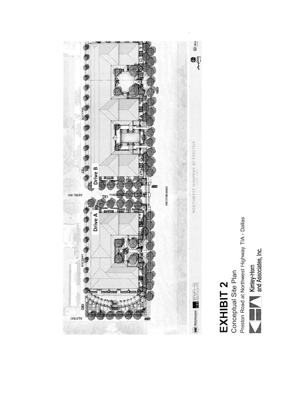
6 Kimley-Hom and Associates, Inc. I. INTRODUCTION A. Purpose Kimley-Horn and Associates, Inc. (Kimley-Horn), was requested to conduct a Traffic Impact Analysis (TIA) of future traffic conditions associated with the proposed multifamily development located on the northeast corner of Preston Road and Northwest Highway in Dallas, Texas. Exhihit 1 is a vicinity map illustrating the project location, and Exhibit 2 shows the proposed site plan with roadway modifications. This report has been prepared in accordance with the City of Dallas Traffic Impact Analysis guidelines to document the results of this study. This study is intended to identify traffic generation characteristics, identify potential traffic related impacts on the local street system, and to develop mitigation measures required for identified impacts. B. Methodology The traffic evaluation was comprised of six scenarios for which weekday AM and PM peak hour intersection level of service analyses were performed. For both unsignalized and signalized intersections, the capacity analyses were conducted using the Synchro'l" software package and its associated Highway Capacity Manual reports. Table 1 provides a summary of the assumptions used in each of the analysis scenarios. Section III describes each analysis scenario in further detail. Table 1 - Analysis Scenario Summary Scenario Existing Cond itions (2013) Table 1 - Analysis Scenario Summary Roadway Development Assumptions Traffic Volumes Conditions Existing Existing Existing Existing + No-Build Conditions Existing + 3 years of TxDOT Existing (2016) background growth Improvements Existing + Existing 3 years of Existing + Proposed Build-Out Conditions TxDOT background growth Multifamily Development Scenario 1 (2016) Improvements + Proposed Multifamily (1,463 Daily Trips) New Driveways Development Build-Out Conditions Existing + Existing + 3 years of Existing + Proposed Scenario 2 (2016) TxDOT background growth + Multifamily Development (Considering Existing Improvements + Proposed Multifamily (798 Daily Trips) Zoning) New Driveways Development Existing + No-Build Conditions Existing + 8 years of TxDOT Existing (2021) background growth Improvements Existing + Existing 8 years of Build-Out Conditions TxDOT Existing Proposed background growth + Scenario I (2021) Improvements + Multifamily Development Proposed Multifamily New Driveways Development Multifamily Development, Dallas, Texas Page 1

7 EXHIBIT 1 Vicinity Map Preston Road at Northwest Highway TIA Dallas Kimley Hom and Associates, Inc, North i
8
9 II. EXISTING AND FUTURE AREA CONDITIONS A. Roadway Characteristics Based on City of Dallas staff requests, the following signalized intersections were evaluated as part of this study: Northwest Highway at Preston Road Northwest Highway at Pickwick Lane In addition, the following unsignalized and site driveway intersections were also evaluated: Northwest Highway at Edgemere Road Preston Road at Averill Way Preston Road at Del Norte Lane Averill Way at Bandera Avenue Averill Way at Driveways A and B Northwest Highwav Northwest Highway is a six-lane boulevard that forms a regional loop at an approximate 5-mi\e radius from downtown Dallas (also referred to as Loop 12). In the vicinity of the site, Northwest Highway has a posted speed limit of 35 MPH and provides east-west connectivity to US 75 and the Dallas North Tollway. Northwest Highway forms signalized intersections with Preston Road and Pickwick Lane near the proposed development. Northwest Highway is designated as a Principal Arterial on the City of Dallas Thoroughfare Plan. DART provides bus stops on Northwest Highway between Preston Road and Pickwick Lane with the westbound stop immediately in front of the proposed development. Based on information obtained from the City of Dallas and TxDOT, Northwest Highway is planned to be widened at Preston Road to provide for dual eastbound and westbound left turn lanes. The project will be constructed by TxDOT and is expected to let for construction in August of This improvement has been included in the analysis for all background and buildout conditions. Preston Road Preston Road is a six-lane boulevard that aligns east of the Dallas North Tollway and extends north outside of the city limits and turns into Oak Lawn Avenue and Turtle Creek Boulevard as it enters Uptown. In the vicinity of the site, Preston Road has a posted speed limit of 30 MPH and is designated as a Principal Arterial on the City of Dallas Thoroughfare Plan. DART provides a northbound bus stop on Preston Road just south of Averill Way. Averill Way Averiil Way is a two-lane undivided roadway that intersects Preston Road just north of Northwest Highway. Averill Way 'is stop-controlled on the eastbound and westbound approaches at Preston Road and has no posted speed limit. West of Preston Road, Averill Way is a privately owned driveway that serves a small residential community. East of Preston Road, Averill Way intersects Multifamily Development, Dallas, Texas
10 Kimley-Hom and Associates, Inc. Bandera Avenue at a "T" intersection. Averill Way is not classified on the City of Dallas Major Thoroughfare Plan and is a local roadway. Del Norte Lane Del Norte Lane is a two-lane undivided residential roadway that intersects Preston Road just north of Averill Way and connects Preston Road to Edgemere Road. Del Norte Lane is stop-controlled on the westbound approach and has no posted speed limit. Del Norte Lane is not classified on the City of Dallas Major Thoroughfare Plan and is a local roadway. Pickwick Lane Pickwick Lane is a two-lane undivided residential collector that intersects Northwest Highway at a signal just east of Preston Road. Pickwick Lane connects Northwest Highway to Bandera Avenue just east of the proposed development and has no posted speed limit. On-street parking is permitted on both sides of Pickwick Lane away from intersections. Pickwick Lane is not classified on the City of Dallas Major Thoroughfare Plan and is a local roadway. Edgemere Road Edgemere Road is a two-lane divided residential roadway within the study area, and transitions to a two-lane undivided roadway just north of Del Norte Lane. Edgemere Road is unsignalized at Northwest Highway, Bandera Avenue, and Del Norte Lane. Edgemere Road forms a "T" intersection at Northwest Highway and connects to Walnut Hill Lane north of the site. On-street parking is allowed on both sides of the roadway and the posted speed limit is 30 MPH. Edgemere Road is not classified on the City of Dallas Major Thoroughfare Plan and is a local roadway. Exhibit 3 shows the existing lane configuration and intersection control for the study area. B. Existing Study Area The project site is currently occupied by 12 single family homes and 24 apartment units. The existing development that will be displaced as part of this project currently produces 210 vehicle trips per day according to ITE, Trip Generation Manual. The existing development is served by Townhouse Rowand another parallel roadway, both of which are private roads that will be removed with the new development. The existing property is currently zoned residential MF-l (A) for a maximum of 120 units, which has the potential to produce 798 vehicles trips per day. Development, Page 5
11 Kimlay-Hom and Associates, Inc. -0 cr: c ~QJ t5: North I Not To Scale 'D cr: ~QJ E QJ QO 'D w ~ Del Norte Rd. Alleyway Averill Way <{ Q) > ~~I~ +~ Alleyway 0$> o l- OJ V) STOP Bandera Ave. Northwest Highway QJ > c o ""I' S ~~ ~l>,f* ~..IL~ d) ~.. \~. I~ d) ~~ "(/ ~ :if 0.. o I- =i> 'D cr: c ~QJ t5: LEGEND: Signalized Intersection STOP Stop-Controlled Approach <1=== Travel Lane Tum Bav -* rovements TWLTl T\vo-Way Left-Turn Lane EXHIBIT 3 Lane Assignment and Intersection Control Preston Road at Northwest Highway TIA - Dallas
12 Kimley-Hom and Associates, Inc. C. Proposed Development Based on information provided by the Client, the proposed project will replace the existing single family and multifamily property with a 220 unit multifamily development. Access to the development will be provided on Averill Way via two driveways; one accessing the north underground parking garage (Driveway A) and one accessing the south underground parking garage (Driveway B). Driveway locations are depicted in Exhibit 2 and as described below: Driveway A - This driveway will serve as the entrance to the northern side of the property and north garage. Driveway A will form an unsignalized intersection with Averill Way and will be stop controlled on the southbound approach. Driveway A will have one lane in and one lane out. Driveway B This driveway will serve as the entrance to the southern side of the property and south garage. Driveway B will form an unsignalized intersection with Averill Way and will be stop controlled on the northbound approach. Driveway B will have one lane in and one lane out. D. Existing Traffic Volumes AM and PM peak hour turning movement counts for the study intersections were conducted on November 14, 2013 at the following intersections: Northwest Highway at Preston Road Northwest Highway at Pickwick Lane Northwest Highway at Edgemere Road Preston Road at Averill Way Preston Road at Del Norte Lane Averill Way at Bandera Avenue New bi-directional tube counts were also conducted at the following locations on October 24th, 2013: Bandera Avenue east of Pickwick Lane (1,551 daily vehicles) Bandera Avenue west of Pickwick Lane (950 daily vehicles) Averill Way west of Pickwick Lane (809 daily vehicles) Averill Way east of Preston Road (1,846 daily vehicles) Alley between Del Norte and Averill Way (26 daily vehicles) Preston Road north of Averill Way (20,337 daily vehicles) The existing AM and PM peak hour traffic volumes can be seen in Exhibit 4 and the raw count sheets are provided in the Appendix. Page 7
13 Kimley Hom and Asscdates, Inc. North I Not To Scale "0 a: c.8 '" i:' 0.. "0 a: i:' ill E ill an "0 UJ 1100 Del Norte Rd. (6) 5 (3) Alleyway 1 (2) => Bandera Ave. Averill Way 59 (35) ~ Alleyway (37) 17 (46) 1 (8) 10 (27) (66) 22 Northwest Highway (187) ~ 2450 (1657) 143 (172) 5 15 (55) 2633 (1963) 89 (244) 1370 (2450) 78 (133) (116) (574) (105) (84) 1473 (2717) "0 a: c.8 '" i:' 0.. LEGEND: )«7). x Weekday AM Peak Hour Turning Movements Y Weekday PM Peak Hour Turninq Movements Volumes may not sum from point to point due to rounding and presence of smaller driveways not included in analysis. EXHIBIT Existing Traffic Volumes Preston Road at Northwest Highway TIA - Dallas

14 Kimley-Hom and Associates, Inc. III. PROJECT TRAFFIC CHARACTERISTICS A. Site-Generated Traffic Site-generated traffic estimates are determined through a process known as trip generation. Rates and equations are applied to the proposed land use to estimate traffic generated by the development during a specific time interval. The acknowledged source for trip generation rates is the current edition of Trip Generation 1 published by the Institute of Transportation Engineers (ITE). ITE has established trip rates in nationwide studies of similar land uses. Applying these trip generation rates to the proposed building program results in the daily, AM peak hour, and PM peak hour trips for the development. Trip generation is calculated using one-way trips, where each entry or exit from the site is recorded as one trip. Therefore, each vehicle visiting the site is counted as one inbound trip and one outbound trip. In evaluating the site generated trips associated with the proposed development, there were two scenarios considered. Scenario 1 is shown in Table 2 which depicts the number of trips associated with the full build out of the 220 units irrespective of the existing land use or existing potential trips that are associated with the current zoning. Scenario 2 is shown in Table 3 and it represents the net amount of trips that can be expected from this proposed development based on the current zoning (if the property was built out) which according to the Client can support 120 units. When taking into account the trips associated with the existing zoning for the subject property, the net new daily trips equal 798 as compared to Scenario 1 at 1,463. Although Scenario 2 is shown below and included as a comparison scenario for the year 2016 build analysis, the trips associated with the fidl-build out of the development irrespective of the current zoning were used as thefocused analysis for this study and its recommendations. Table 2 - Trip Generation for Proposed Land Uses (Scenario 1) Table 3 - Trip Generation for Proposed Land Uses (Scenario 2) Trip Generation and pass-by trips based on ITE's Trip Generation. 9th Edition. 1 Institute of Transportation Engineers, Trip Generation: An Information Report, Seventh Edition, Washington DC, Multifamily Development, Texas Page
15 Kimley-Hom and Associates, Inc. B. Trip Distribution and Traffic Assignment Distribution of site traffic onto the street system was based on the area street system characteristics, existing traffic patterns, existing and anticipated development in the surrounding areas, and the locations of the proposed driveway access to/from the site. Exhibit 5 presents the inbound and outbound traffic assignment for the site. Multiplying the trip generation by the traffic assignment percentages results in the turning movements at each intersection. The site generated AM and PM peak hour turning movements are shown in Exhibit 6. C. Development of 2016 Background Traffic In order to obtain 2016 background traffic an annual growth rate of 1% was applied for three years to the 2013 existing peak hour volumes to account for ambient growth in traffic. A growth rate of I% per year was determined by comparing traffic volumes on Preston Road just north of Northwest Highway. Counts in year 2011 resulted in 19,649 vehicles per day while counts collected as part of this study were 20,337 vehicles per day which amounts to approximately 1% per year. The resulting 2016 background AM and PM peak hour traffic volumes are shown in Exhibit 7. D. Development of 2016 Background Plus Site Traffic (Scenario 1) Site traffic volumes associated with Scenario 1 were added to the background volumes to represent the estimated total traffic conditions for the 2016 study year after completion of the site. These 2016 AM and PM peak hour total traffic volumes are illustrated in Exhibit 8. E. Development of 2016 Background Plus Site Traffic (Scenario 2) Site traffic volumes associated with Scenario 2 were added to the background volumes to represent the estimated total traffic conditions for the 2016 study year after completion of the site. The results of this analysis can be found in Tables 5 and 6. F, Development of 2021 Background Traffic In order to obtain 2021 background traffic, the same annual growth rate of 1.0% per year was applied for five years to the 2016 background peak hour volumes to account for ambient growth in background traffic. The resulting 2021 background AM and PM peak hour traffic volumes are shown in Exhibit 9. G. Development of 2021 Background Plus Site Traffic (Scenario 1) Site traffic volumes from Scenario I were added to the background volumes to represent the estimated total traffic conditions for the 2021 study year after completion of the site. These 2021 AM and PM peak hour total traffic volumes are illustrated in Exhibit 10. Multifamily Development, Dallas, Texas
16 Klmley Hom and AssQl'viates, -0 a: c o ~ f1:' 0.. Inc, Not North I To Scale "0 a: f1:' (J) E (J) co "0 UJ Del Norte Rd. «(J) > Elo :;;e.~ I Bandera Ave. 8% I =" I =i> Averill Way <? <:;J! ~-(> I -!~ =i>..)l /() U (48%),,f../U 48% (20%) <,Y ~71~::J I~ Alleyway cd OJ > Northwest Highway 30% (10%) (30%) -0 a: c.8 Vl f1:' 0.. LEGEND: )("'{,7y6/,) X% = Percentaqe of Inbound New Site-Generated Traffic (Y%) Percentaqe of Outbound New Site-Generated Traffic Volumes may not sum from point to point due to roundino. EXHIBIT 5 Trip Distribution and Traffic Assignment - New Site Traffic Preston Road at Northwest Highway TIA Dallas
17 Kimley Horn and As$lY'Jates, "0 a:: c 2Vl 2: 0.. Inc, Not North I To Scale "0 a:: 2: OJ E OJ tlo "0 UJ 4 0(0) 0(0) Del Norte Rd. <= 0(0) Alleyway 0(0) =t> «Averill Way o (0)» Alleyway Bandera Ave, Northwest Highway (14) (10)» ~ ro OJ > ~ 4 (18) 2 (9) 0(0) 7 (26) 7 (26) 0(0) 0(0) 0(0) 27 (14) "0 a:: c 2Vl 2: 0.. LEGEND: xiv) x = Weekday AM Peak Hour Turnino Movements Y = Weekday PM Peak Hour Turning Movements Volumes may not sum from point to point due to r and presence of smaller driveways not included in anal EXHIBIT 6 Site-Generated Traffic Volumes New Site Traffic Preston Road at Northwest Highway TIA - Dallas
18 Kimley Horn and AssocIates, -0 0:: c:.8v) 1': e, Ire. r Not To North Scale -0 0:: 1': Q) E Q) QO "0 LU Del Norte Rd. 5 (3) Alleyway 1 (2) c::::i> Bandera Ave. Averill Way Alleyway Northwest Highway 15 (57) 2713 (2022) 92 (251) 1412 (2524) 80 (137) (120) (591) (108) "0 0:: c:.8v) 1': c, LEGEND: XCf) x Weekday AM Peak Hour Turning Movements Y Weekday PM Peak Hour Turrunq Movements Volumes may not sum from point to due to n and~~~,,~~"~~~~~~~~~~.~~~~.~~"~~ ~ EXHIBIT Background Traffic Volumes Preston Road at Northwest Highway TIA - Dallas
19 Kimley Hom and Asso~iates, Inc, -0 a:: c o 1;; ~ 0.. Not North I To Scale -0 c; Q) Q:; E Q) an -0 w Del Norte Rd. 1 (2) 5 (3) Alleyway <t Q) > E Bandera Ave. Averill Way <i= 114 (76 Alleyway (4) (917) (91) en Northwest Highway (1707) 147 (177) Q) > ~ (57) 2720 (2048) 30 (66) 1526 (2809) cc c.8 V> Q) 0: LNEND: X (Y).. ~~~ X Weekday AM Peak Hour Turning Movements Y Weekday PM Peak Hour Turning Movements Volumes may not sum from point to point due to rounding and.jlli'&ence of smaller driveways not included in analysis. EXHIBIT Background Plus Site Traffic Volumes Preston Road at Northwest Highway TIA - Dallas
20 Klmley Hom and Associates, Inc. North I -0 a:: c 0 +-' en OJ 0: Not To Scale -0 a:: OJ (u E OJ on -0 w (13) 6 (8) 14 (2) ~ If īf 528 (977) (6) Del Norte Rd. 5 (3) Alleyway 1 (2) =i> Bandera Ave. Averill Way (4) (888) ~ ~ Alleyway 2 (4) Northwest Highway 436 (203) ~ 541 (497) ~ (144) (126) (621) (114) 32 (69) 1594 (2947) 24 (91) 1595 (2942) -0 a:: c ~ ~ 0.. LEGEND: xt'rt X = Weekday AM Peak Hour Turning Movements Y = Weekday PM Peak Hour Turning Movements Volumes may not sum from point to due to EXHIBIT Background Traffic Volumes Preston Road at Northwest Highway TIA - Dallas
21 Kimley Hom and Associates, "0 cc c: o t> (lj Q:: Inc, Not North I To Scale "0 cc <l.j ill E (lj OJ) "0 UJ 1195 Del Norte Rd. 5 (3) Alleyway 1 (2) =i> «OJ > ~ Bandera Ave. Averill Way Alleyway co (103) (lj > ~ (1794) Northwest Highway 154 (186) (91) 1622 (2956) "0 c:c c:.8vl OJ Q:: LEGEND: X (y-)- x Weekday AM Peak Hour Turning Movements Y = Weekday PM Peak Hour Turning Movements Volumes may not sum from point to due to EXHIBIT Background Plus Site Traffic Volumes Preston Road at Northwest Highway TIA - Dallas
22 IV. TRAFFIC OPERATIONS ANALYSIS Kimley-Horn conducted a traffic operations analysis to determine potential capacity deficiencies in the study years at the identified key intersections. The acknowledged source for determining overall capacity is the current edition of the Highway Capacity Manuaf A. Analysis Methodology Capacity analysis results are listed in terms of Level of Service (LOS). LOS is a qualitative term describing operating conditions a driver will experience while traveling on a particular street or highway during a specific time interval. It ranges from A (very little delay) to F (long delays and congestion). By Dallas standards, LOS D is considered an acceptable LOS during peak periods. Table 4 shows the definition of level of service for signalized and unsignalized intersections Table 4 - Level of Service Definitions A B > 10 and::;20 >10and::;l5 C >20 and ::;35 > 15 and ::;25 D >35 and ::;55 >25 and ::;35 E >55 and ::;80 >35 and ::;50 F >80 >50 Definitions provided from the Highway Capacity Manual, Special Report 209. Transportation Research Board, Existing traffic control conditions (i.e., cycle length, left-turn treatments and phasing at the signalized intersections) were observed during an initial site visit. Additionally, existing signal timing plans were obtained from the City of Dallas for both signalized intersections and used for all analysis scenarios. For the unsignalized analysis, the level of service (LOS) for a two-way stop controlled intersection is determined by the computed or measured control delay and is defined for each minor movement. Level of service for a two-way stop-controlled intersection as a whole is not defined. Level of service for a signalized intersection is defined for the intersection as a whole when determining acceptable conditions. Calculations for the level of service at the key intersections identified for study are provided in the Appendix. The analyses assumed the lane geometry and intersection control shown in Exhibit 3. Tables 5 and 6 show the AM and PM peak hour intersection analysis results for each scenario. 2 Transportation Research Board, Highway Capacity Manual, Special Report 209, Washington DC, Multifamily Development, Dallas, Texas Page 17
23 /\1'1';12014 Kimley-Hom and Associates, Inc.

24 Kimley-Horn and Associates, Inc. Preston Rd. at Averil! Way Preston Rd. at Del f f----t---t----f----f-----t j Norte Ln Averiu Way at Bandera Ave Northwest H\'Vy. at f----''''---t t j t---t---'---"1-'--j-='--+---j Edgemere Rd
25 Kimley-Hom and Associates, Inc. B Existing TrafficConditions Under 2013 existing traffic conditions, as shown in Tables 5 and 6, the signalized intersection of Preston Road at Northwest Highway is currently operating at LOS D during the AM peak hour and LOS E during the PM peak hour. Northwest Highway at Pickwick Lane is currently operating at LOS A during both peak periods. The delays for intersection approaches are shown so that approaches can be examined for specific impacts of traffic flows. The existing unsignalized intersections all have approaches with a LOS C or better during both peak hours except for Averill Way at Preston Road and Edgemere Road at Northwest Highway. The southbound approach of Edgemere Road at Northwest Highway is currently operating at LOS F during both peak periods and the westbound approach of Averill Way at Preston Road is operating at LOS D and LOS E during the Ai\1 and PM peak hours. C Background Traffic Conditions Operating conditions show slightly increased delay under 2016 background traffic conditions after including the growth in background traffic, as shown in Tables 5 and 6. All intersections continued to operate at the same LOS when compared to the 2013 existing conditions. D Background Plus Site Traffic Conditions (Scenario 1) Under 2016 background plus site traffic conditions, average delays at study intersections tend to increase slightly, as shown in Tables 5 and 6. The signalized intersections operate at the same overall LOS when compared to the 2016 background conditions. All unsignalized intersections continued to operate at the same approach LOS except for the westbound approach of Averill Way at Preston Road which dropped from LOS D to LOS F during the AM peak. Driveway AlB operates at LOS B or better during both peak periods. E Background Plus Site Traffic Conditions (Scenario 2) Under 2016 background plus site traffic conditions for Scenario 2, average delays at study intersections increased slightly. The intersections operate at the same overall LOS when compared to the 2016 background conditions. F Background Traffic Conditions Operating conditions show slightly increased delay under 2021 background traffic conditions when compared to year 2016 after including the growth of additional background traffic. The intersections operate at the same overall LOS when compared to the 2016 background conditions, except for the PM peak at Northwest Hwy. and Preston Rd. which changed from LOS D to E. G Background Plus Site Traffic Conditions Under 2021 background plus site traffic conditions, average delays at study intersections tend to increase slightly over the 2021 background traffic scenario. The signalized intersection of Northwest Highway at Preston Road maintained LOS D in the AiM peak and LOS E during the PM peak when compared to the 2021 background conditions. During the AM peak, the westbound approach of Averill Way at Preston Road dropped from LOS E to LOS F. The site driveways do not experience any significant delays in either the AM or PM peak hours, with all movements at LOS B or better. Multifamily Development, Dallas, Texas
26 H. Link Analysis The link capacity analysis examines the operating conditions of roadway links rather than intersections, and uses the daily traffic rather than the peak hours. The operating condition is defined by the ratio of link volume to link capacity, or VIC. The VIC of the different roadway links that would be impacted by the proposed development's traffic was calculated for the 2016 background and total traffic scenarios. The maximum daily capacity is calculated to be ten times the maximum hourly capacity, so the threshold for possible daily capacity is significantly lower than if the roadway was at maximum flow for an entire day. These theoretical capacity volumes were obtained from the North Central Texas Council of Governments (NCTCOG) tables of service volumes by lane, which are duplicated in the Appendix. For finding the capacity of each roadway, functional class is set to Principal Arterial for Preston Road and Collector/Local for Averill Way with the area type set to Urban Residential. The daily background volume on each link is found by applying the growth factor to known daily link volumes, then adding the percentage of the daily site traffic that uses each link. Table 7 summarizes daily volumes and volume-to-capacity ratios of the links considered for the 2016 and 2021 scenarios. Page
27 Kimley-Hom and Associates, Inc. Table 7 - Link Capacity Analysis Roadway Volumes Capacity VIC Ratios From To Daily Number Median LOS 'E' vic Preston Road-20l3 Existing Year Volumes Of Lanes Type Capacity Ratio LOS North of Averill Way n,337 6 Divided SI,OOO 0.40 AlB Preston Road Projections - Without Site North of Averill Way ,953 6 Divided SI,OOO 0.41 AlB Preston Road Projections - With Site North of Averill Way Background 20,953 Proposed Site 20.0% 293 Preston Road Projections - Without Site Total: Divided SI,OOO 0.42 AlB North of Averill Way Divided Sl.OOO 0.43 AlB Preston Road Projections - With Site North of Averill Way Background Proposed Site 20.0% 293 Total: Divided 51, AlB Averill Way Existing : East of Preston Road 2013 ],846 2 Divided 9, AlB Averill Way Projections - Without Site East of Prest on Road ] 2 Divided 9,SOO 020 AlB Averill Way Projections - With Site East of Preston Road Background Averill Way Projections - Without Site Proposed Site 80.0% l.l Total: 3ml 2 Divided 9, AlB East of Preston Road Divided 9, AlB Averill Way Projections - With Site Notes: East of Preston Road Background Proposed Site 80.0"10 1.I70 Total: Divided 9.S AlB I Count data from KHA 2013 counts Yo lumcs grown at 1% per year VIC LOS VIC LOS -D--.,. Link Capacity from North Central Texas Council of Governmcnts, < 0.45 AlB <0.80 using Urban Residential District <0.65 C < 1.00 E > 1.00 F As seen in Table 7, the link analysis shows that Preston Road and Averill Way are currently operating under capacity. Multifamily Development, Dallas, Texas
28 V. CONCLUSIONS AND RECOMMENDATIONS Based on the analysis presented in this report, the proposed multifamily development at Preston Road and Averill Way can be successfully incorporated into the surrounding roadway network. The most congested of the study intersections is the signalized intersection of Preston Road at Northwest Highway which is already operating at oversaturated conditions with current traffic volumes. Adding the proposed traffic expected to be generated by this site will slightly increase the delay during both year 2016 conditions and year 2021 conditions. Although the delay will increase by a small margin, the proposed development will only contribute an additional 880 vehicles per day to the existing ~ 74,000 vehicles entering the intersection of Preston Road at Northwest Highway during a typical weekday. The planned improvements by TxDOT to provide eastbound and westbound dual left tum lanes will improve the intersection by adding capacity, particularly in the PM peak hour when left turns are heaviest. The other signalized intersection of Northwest Highway at Pickwick Lane is expected to operate at LOS A during all scenarios evaluated. The unsignalized intersections within the study area including the proposed site driveways are expected to operate at LOS C or above except for Northwest Highway at Edgemere Road and the westbound approach of Averill Way at Preston Road. The southbound approach of Edgemere Road at Northwest Highway is currently operating at LOS F and this oversaturated condition will continue due to the significant volumes on Northwest Highway. The westbound left tum from Averill Way onto Preston Road is currently operating at LOS DIE conditions and will drop to LOS ElF conditions with the proposed traffic. Although the delay associated with the westbound approach is relatively high, the 95% queue length is not excessive at 4-5 vehicles. Although not necessarily based on this analysis, one mitigation measure that would improve southbound through traffic on Preston Road would be to construct as southbound left turn lane on Preston Road at Averill Way. With the additional site traffic the southbound left tum volumes will be close to 80 vehicles during the PM peak hour. Providing a storage and deceleration lane for vehicles to not obstruct through capacity on Preston Road would provide capacity benefits. Texas Page
Henderson Avenue Mixed-Use Development
 Zoning Case: Z145-3 Traffic Impact Analysis Henderson Avenue Mixed-Use Development Dallas, TX October 26 th, 216 Kimley-Horn and Associates, Inc. Dallas, Texas Project #644827 Registered Firm F-928 Traffic
6060 North Central Expressway Mixed-Use Site Dallas, Texas
 Volume 1 Traffic Impact Analysis 6060 North Central Expressway Mixed-Use Site Dallas, Texas April 30, 2018 Kimley-Horn and Associates, Inc. Dallas, Texas Project #063238300 Registered Firm F-928 Traffic
Volume 1 Traffic Impact Analysis. Texas Odyssey TIA Dallas, Texas. Kimley-Horn and Associates, Inc. Dallas, Texas. May 23, 2018
 Volume 1 Traffic Impact Analysis Texas Odyssey TIA Dallas, Texas May 23, 2018 Kimley-Horn and Associates, Inc. Dallas, Texas Project #064529800 Registered Firm F-928 Traffic Impact Analysis Texas Odyssey
Transportation Impact Study for Abington Terrace
 Transportation Impact Study for Abington Terrace Abington Township, Montgomery County, PA Sandy A. Koza, P.E., PTOE PA PE License Number PE059911 Prepared by McMahon Associates, Inc. 425 Commerce Drive,
Traffic Impact Analysis Chatham County Grocery Chatham County, NC
 Chatham County Grocery Chatham County, NC TABLE OF CONTENTS 1. INTRODUCTION... 1 1.1. Location and Study Area... 1 1.2. Proposed Land Use and Access... 2 1.3. Adjacent Land Uses... 2 1.4. Existing ways...
Traffic Impact Analysis Walton Acres at Riverwood Athletic Club Clayton, NC
 Traffic Impact Analysis Walton Acres at Riverwood Athletic Club Clayton, NC 1. TABLE OF CONTENTS INTRODUCTION...1 1.1. Site Location and Study Area...1 1.2. Proposed Land Use and Site Access...2 1.3.
5858 N COLLEGE, LLC N College Avenue Traffic Impact Study
 5858 N COLLEGE, LLC nue Traffic Impact Study August 22, 2016 Contents Traffic Impact Study Page Preparer Qualifications... 1 Introduction... 2 Existing Roadway Conditions... 5 Existing Traffic Conditions...
Traffic Impact Study. Westlake Elementary School Westlake, Ohio. TMS Engineers, Inc. June 5, 2017
 TMS Engineers, Inc. Traffic Impact Study Westlake Elementary School Westlake, Ohio June 5, 2017 Prepared for: Westlake City Schools - Board of Education 27200 Hilliard Boulevard Westlake, OH 44145 TRAFFIC
Traffic Impact Study WestBranch Residential Development Davidson, NC March 2016
 Traffic Impact Study WestBranch Residential Development Davidson, NC March 216 TRAFFIC IMPACT STUDY FOR THE WestBranch Residential Development LOCATED IN DAVIDSON, NC Prepared For: Lennar Carolinas, LLC
Walmart (Store # ) 60 th Street North and Marion Road Sioux Falls, South Dakota
 60 th Street North and Marion Road Sioux Falls, South Dakota") Walmart (Store #4865-00) 60 th Street North and Marion Road Sioux Falls, South Dakota Prepared for: Wal-Mart Stores, Inc. Bentonville, Arkansas Prepared by: Kimley-Horn and Associates, Inc. ã2013 Kimley-Horn
Walmart (Store #4865-00) 60 th Street North and Marion Road Sioux Falls, South Dakota Prepared for: Wal-Mart Stores, Inc. Bentonville, Arkansas Prepared by: Kimley-Horn and Associates, Inc. ã2013 Kimley-Horn
King Soopers #116 Thornton, Colorado
 Traffic Impact Study King Soopers #116 Thornton, Colorado Prepared for: Galloway & Company, Inc. 1.0 EXECUTIVE SUMMARY King Soopers #116, a grocery marketplace anchored commercial development, is proposed
Traffic Impact Study for Rolling Ridge Redevelopment
 Traffic Impact Study for Rolling Ridge Redevelopment Webster Groves, Missouri October 19, 2018 Prepared For: Gershman Commercial Real Estate 150 North Meramec Avenue Suite 500 St. Louis, Missouri 63105
Appendix C. NORTH METRO STATION AREA TRAFFIC IMPACT STATEMENT 88th Avenue Station
 Appendix C NORTH METRO STATION AREA TRAFFIC IMPACT STATEMENT 88th Avenue Station Prepared for: Regional Transportation Department and URS Corporation as part of the North Metro EIS David Evans and Associates,
EAST AND SOUTH STREET CITY OF ANAHEIM, CALIFORNIA
 T R A F F I C I M P A C T A N A LY S I S EAST AND SOUTH STREET CITY OF ANAHEIM, CALIFORNIA April 217 T R A F F I C I M P A C T A N A LY S I S EAST AND SOUTH STREET CITY OF ANAHEIM, CALIFORNIA Submitted
TRANSPORTATION ANALYSIS REPORT US Route 6 Huron, Erie County, Ohio
 TRANSPORTATION ANALYSIS REPORT US Route 6 Huron, Erie County, Ohio December 12, 2012 Prepared for: The City of Huron 417 Main Huron, OH 44839 Providing Practical Experience Technical Excellence and Client
TRAFFIC IMPACT ANALYSIS
 TRAFFIC IMPACT ANALYSIS FOR THE CHAMPAIGN UNIT#4 SCHOOL DISTRICT PROPOSED HIGH SCHOOL (SPALDING PARK SITE) IN THE CITY OF CHAMPAIGN Final Report Champaign Urbana Urbanized Area Transportation Study 6/24/2014
Walton Acres at Riverwood Athletic Club Clayton, North Carolina
 9. CONCLUSIONS This Traffic Impact Analysis Update was conducted to determine the potential traffic impacts of the proposed Walton Acres at Riverwood Athletic Club residential development, located east
Traffic Circulation Study for Neighborhood Southwest of Mockingbird Lane and Airline Road, Highland Park, Texas
 ARIZONA TEXAS NEW MEXICO OKLAHOMA February 13, 2015 Mr. Meran Dadgostar P.E., R.S. Town of Highland Park 4700 Drexel Dr. Highland Park, Texas 75205 Re: Traffic Circulation Study for Neighborhood Southwest
Chapter 4 Traffic Analysis
 Chapter 4 Traffic Analysis PURPOSE The traffic analysis component of the K-68 Corridor Management Plan incorporates information on the existing transportation network, such as traffic volumes and intersection
TRAFFIC IMPACT STUDY And A TRAFFIC SIGNAL WARRANT ANALYSIS FOR A SENIOR LIVING AND APARTMENT DEVELOPMENT
 TRAFFIC IMPACT STUDY And A TRAFFIC SIGNAL WARRANT ANALYSIS FOR A SENIOR LIVING AND APARTMENT DEVELOPMENT DEERFIELD TOWNSHIP, WARREN COUNTY, OHIO Nantucket Circle and Montgomery Road () Prepared for: ODLE
Project Report. South Kirkwood Road Traffic Study. Meadows Place, TX October 9, 2015
 Meadows Place, TX October 9, 2015 Contents 1 Introduction... 1 2 Data Collection... 1 3 Existing Roadway Network... 2 4 Traffic Volume Development... 2 5 Warrant Analysis... 3 6 Traffic Control Alternative
FRONT RANGE CROSSINGS TRAFFIC IMPACT STUDY
 FRONT RANGE CROSSINGS TRAFFIC IMPACT STUDY Prepared for: City of Thornton And Colorado Department of Transportation Prepared by: 11 Blake Street, Suite 2 Denver, Colorado 822 Contact: Brian Bern, PE, PTOE
OTTAWA TRAIN YARDS PHASE 3 DEVELOPMENT CITY OF OTTAWA TRANSPORTATION IMPACT STUDY. Prepared for:
 OTTAWA TRAIN YARDS PHASE 3 DEVELOPMENT CITY OF OTTAWA TRANSPORTATION IMPACT STUDY Prepared for: The Ottawa Train Yards Inc. 223 Colonnade Road South, Suite 212 Nepean, Ontario K2E 7K3 January 17, 2012
FINAL DESIGN TRAFFIC TECHNICAL MEMORANDUM
 FINAL DESIGN TRAFFIC TECHNICAL MEMORANDUM July 2014 FINAL (SR 43) Project Development and Environment Study From State Road 60 (Adamo Drive) to I-4 (SR 400) Hillsborough County, Florida Work Program Item
MEDICAL/OFFICE BUILDING 1637 BANK STREET OTTAWA, ONTARIO TRANSPORTATION OVERVIEW. Prepared for:
 MEDICAL/OFFICE BUILDING 1637 BANK STREET OTTAWA, ONTARIO TRANSPORTATION OVERVIEW Prepared for: 2434984 Ontario Inc. 13-5510 Canotek Road Ottawa, Ontario K1J 9J5 June 4, 2015 115-613 Report_2.doc D. J.
MEETING FACILITY 2901 GIBFORD DRIVE CITY OF OTTAWA TRANSPORTATION BRIEF. Prepared for: Holiday Inn Express 2881 Gibford Drive Ottawa, ON K1V 2L9
 MEETING FACILITY 2901 GIBFORD DRIVE CITY OF OTTAWA TRANSPORTATION BRIEF Prepared for: Holiday Inn Express 2881 Gibford Drive Ottawa, ON K1V 2L9 December 18, 2012 112-566 Brief_1.doc D. J. Halpenny & Associates
Traffic Impact Study Little Egypt Road Development Denver, North Carolina June 2017
 Traffic Impact Study Little Egypt Road Development Denver, North arolina June 2017 N. Little Egypt Road DQ\ QDQFLQJ VDOHV RU RWKHU SHUIRUPDQFH EDVHG FULWHULD Proposed Site Driveways Site Driveway 1 TRAFFI
TRAFFIC ASSESSMENT River Edge Colorado
 TRAFFIC ASSESSMENT River Edge Colorado Submitted by: Fehr & Peers 621 17th Street, Ste. 231 Denver, CO 8293 (33) 296-43 December, 21 App. M-2 Traffic Assessment River Edge Colorado December 21 TABLE OF
Marina Loft (DRC 51-R-12)
") Marina Loft (DRC 51-R-12) traffic study prepared for: Cymbal Development OCtober 2012 Traf Tech October 1, 2012 Mr. Asi Cymbal - President Cymbal Development 3470 North Miami Avenue Upper Suite Miami,
Marina Loft (DRC 51-R-12) traffic study prepared for: Cymbal Development OCtober 2012 Traf Tech October 1, 2012 Mr. Asi Cymbal - President Cymbal Development 3470 North Miami Avenue Upper Suite Miami,
Shockoe Bottom Preliminary Traffic and Parking Analysis
 Shockoe Bottom Preliminary Traffic and Parking Analysis Richmond, Virginia August 14, 2013 Prepared For City of Richmond Department of Public Works Prepared By 1001 Boulders Pkwy Suite 300, Richmond, VA
Magnolia Place. Traffic Impact Analysis. Prepared for: City of San Mateo. Prepared by: Hexagon Transportation Consultants, Inc.
 Magnolia Place Traffic Impact Analysis Prepared for: City of San Mateo Prepared by: Hexagon Transportation Consultants, Inc. Updated January 4, 2010 Table of Contents 1. Introduction...1 2. Existing Conditions...6
Chapter 16: Traffic and Parking A. INTRODUCTION
 Chapter 6: Traffic and Parking A. ITRODUCTIO This chapter examines the potential traffic and parking impacts of the proposed Fresh Kills Park roads. The analysis of transit and pedestrians is presented
INDUSTRIAL BUILDING 3009 HAWTHORNE ROAD CITY OF OTTAWA TRANSPORTATION OVERVIEW REVISED. Prepared for: Canada Inc.
 INDUSTRIAL BUILDING 3009 HAWTHORNE ROAD CITY OF OTTAWA TRANSPORTATION OVERVIEW REVISED Prepared for: 7849648 Canada Inc. Octiober 1, 2015 114-598 Overview_2.doc D. J. Halpenny & Associates Ltd. Consulting
1609 E. FRANKLIN STREET HOTEL TRAFFIC IMPACT STUDY EXECUTIVE SUMMARY
 1609 E. FRANKLIN STREET HOTEL TRAFFIC IMPACT STUDY EXECUTIVE SUMMARY Prepared for: The Town of Chapel Hill Public Works Department Traffic Engineering Division Prepared by: HNTB North Carolina, PC 343
DIMARCO CANANDAIGUA PROPERTIES HOUSING PROJECT CANANDAIGUA, ONTARIO COUNTY, NEW YORK
 TRAFFIC IMPACT STUDY FOR THE DIMARCO CANANDAIGUA PROPERTIES HOUSING PROJECT CANANDAIGUA, ONTARIO COUNTY, NEW YORK MARCH 14, 2017 PREPARED FOR: 1950 Brighton Henrietta Town Line Rd Rochester, NY 14623 PREPARED
Glenn Avenue Corridor Traffic Operational Evaluation
 Glenn Avenue Corridor Traffic Operational Evaluation PREPARED FOR: THE CITY OF AUBURN PREPARED BY: DECEMBER 2007 Glenn Avenue Corridor Study--Auburn, Alabama TABLE OF CONTENTS Introduction... 1 Background
HENDERSON DEVELOPMENT 213, 217, 221, 221 ½, 223 HENDERSON AVENUE and 65 TEMPLETON STREET OTTAWA, ONTARIO TRANSPORTATION OVERVIEW.
 HENDERSON DEVELOPMENT 213, 217, 221, 221 ½, 223 HENDERSON AVENUE and 65 TEMPLETON STREET OTTAWA, ONTARIO TRANSPORTATION OVERVIEW Prepared for: 2294170 Ontario Inc. February 2, 2017 117-652 Report_1.doc
OFFICE/RETAIL DEVELOPMENT 1625 BANK STREET OTTAWA, ONTARIO TRANSPORTATION BRIEF. Prepared for: Canada Inc.
 OFFICE/RETAIL DEVELOPMENT 1625 BANK STREET OTTAWA, ONTARIO TRANSPORTATION BRIEF Prepared for: 9402209 Canada Inc. December 15, 2015 115-625 Report_2.doc D. J. Halpenny & Associates Ltd. Consulting Transportation
NEW YORK CENTRAL PARK SUBDIVISION BLAIS STREET/ST-PIERRE STREET EMBRUN, ONTARIO TRAFFIC IMPACT STUDY. Prepared for:
 NEW YORK CENTRAL PARK SUBDIVISION BLAIS STREET/ST-PIERRE STREET EMBRUN, ONTARIO TRAFFIC IMPACT STUDY Prepared for: Solidex Holdings Limited & Investissement Maurice Lemieux Investments Attn: Mr. Anthony
Table of Contents FIGURES TABLES APPENDICES. Traffic Impact Study Hudson Street Parking Garage MC Project No.: A Table of Contents
 Traffic Impact Study Hudson Street Parking Garage MC Project No.: 151714A Table of Contents Table of Contents I. INTRODUCTION... 2 II. EXISTING CONDITIONS... 5 III. 215 EXISTING TRAFFIC CONDITIONS... 6
HOLIDAY INN HOTEL 235 KING EDWARD AVENUE CITY OF OTTAWA TRANSPORTATION BRIEF. Prepared for:
 HOLIDAY INN HOTEL 235 KING EDWARD AVENUE CITY OF OTTAWA TRANSPORTATION BRIEF Prepared for: Momentum Planning & Communications 1165 Greenlawn Crescent Ottawa, ON K1L 6C2 June 29, 2015 115-618 Brief_1.doc
METHODOLOGY. Signalized Intersection Average Control Delay (sec/veh)
") Chapter 5 Traffic Analysis 5.1 SUMMARY US /West 6 th Street assumes a unique role in the Lawrence Douglas County transportation system. This principal arterial street currently conveys commuter traffic
Chapter 5 Traffic Analysis 5.1 SUMMARY US /West 6 th Street assumes a unique role in the Lawrence Douglas County transportation system. This principal arterial street currently conveys commuter traffic
Existing Conditions. Date: April 16 th, Dan Holderness; Coralville City Engineer Scott Larson; Coralville Assistant City Engineer
 Date: April 16 th, 2015 To: From: Re: Dan Holderness; Coralville City Engineer Scott Larson; Coralville Assistant City Engineer Darian Nagle-Gamm, Traffic Engineering Planner Highway 6 (2 nd Street) /
Appendix B. Environmental Resource Technical Memorandum. Assessment on Travel Pattern and Access Impacts
 Appendix B Environmental Resource Technical Memorandum Assessment on Travel Pattern and Access Impacts TECHNICAL MEMORANDUM ENVIRONMENTAL RE-EVALUATION FOR UNION STATION TO OAK CLIFF DALLAS STREETCAR To:
TRAFFIC IMPACT STUDY. Creekside Thornton, Colorado. For. August 2015 November 2015 Revised: August Prepared for:
 TRAFFIC IMPACT STUDY For Creekside Thornton, Colorado August 215 November 215 Revised: August 216 Prepared for: Jansen Strawn Consulting Engineers 45 West 2 nd Avenue Denver, Colorado 8223 Prepared by:
2136 And 2148 Trafalgar Road Townhouse Development Traffic Brief. Paradigm Transportation Solutions Limited
 2136 And 2148 Trafalgar Road Townhouse Development Traffic Brief Paradigm Transportation Solutions Limited March 217 March 217 Project: 1627 Diana Vlasic, M.C.I.P., R.P.P Metropolitan Consulting 445 Paletta
TRAFFIC IMPACT STUDY COMPREHENSIVE UPDATE TOWN OF THOMPSON S STATION, TENNESSEE PREPARED FOR: THE TOWN OF THOMPSON S STATION
 TRAFFIC IMPACT STUDY COMPREHENSIVE UPDATE TOWN OF THOMPSON S STATION, TENNESSEE PREPARED FOR: THE TOWN OF THOMPSON S STATION Transportation Consultants, LLC 1101 17 TH AVENUE SOUTH NASHVILLE, TN 37212
List of Exhibits...ii
 One Brickell Traffic Study TABLE OF CONTENTS List of Exhibits...ii EXECUTIVE SUMMARY...1 1. INTRODUCTION...2 1.1 Study Area...2 1.2 Study Objective...5 2. EXISTING TRAFFIC CONDITIONS...6 2.1 Data Collection...6
Harrah s Station Square Casino
 Transportation Analysis Harrah s Station Square Casino Pittsburgh, Pennsylvania Submitted To: City of Pittsburgh and Pennsylvania Gaming Control Board Prepared By: DKS Associates GAI Consultants December
THIS PAGE LEFT BLANK INTENTIONALLY
 GA SR 25 Spur at Canal Road Transportation Impact Analysis PREPARED FOR GLYNN COUNTY, GEORGIA 1725 Reynolds Street, Suite 300 Brunswick, Georgia 31520 PREPARED BY 217 Arrowhead Boulevard Suite 26 Jonesboro,
TRAFFIC IMPACT ANALYSIS OF PROPOSED CHESTNUT HILL COLLEGE MASTER PLAN DEVELOPMENT
 TRAFFIC IMPACT ANALYSIS OF PROPOSED CHESTNUT HILL COLLEGE MASTER PLAN DEVELOPMENT Prepared by Orth-Rodgers & Associates, Inc. December 14, 2009 Updated November 9, 2010 230 South Broad Street Philadelphia
Troutbeck Farm Development
 Troutbeck Farm Development Willistown Township, Chester County PA For Submission To: Willistown Township Last Revised: October, 4 TPD# INLM.A. 5 E. High Street Suite 65 Pottstown, PA 9464 6.36.3 TPD@TrafficPD.com
APPENDIX F SUPPLEMENTAL TRAFFIC DATA
 APPENDIX F SUPPLEMENTAL TRAFFIC DATA Environmental and Planning Consultants 440 Park Avenue South 7th Floor New York, NY 10016 tel: 212 696-0670 fax: 212 213-3191 www.akrf.com Draft Memorandum To: Michael
Figure 1: Vicinity Map of the Study Area
 ARIZONA TEXAS NEW MEXICO OKLAHOMA May 5, 2016 Mr. Anthony Beach, P.E. BSP Engineers 4800 Lakewood Drive, Suite 4 Waco, Texas 76710 Re: Intersection and Access Analysis along Business 190 in Copperas Cove
TABLE TRAFFIC ANALYSIS SCENARIOS
 4.11 TRANSPORTATION The potential traffic impacts of the proposed project are evaluated in the Buena Park Beach/Orangethorpe Mixed Use Project Traffic Analysis (Traffic Analysis) by Austin-Foust Associates
Design Traffic Technical Memorandum
 State Road 7 Extension PD&E Study Design Traffic Technical Memorandum Palm Beach County, FL October 2010 State Road 7 Extension PD&E Study Design Traffic Technical Memorandum Palm Beach County, FL Prepared
URBAN QUARRY HEADQUARTERS 2717 STEVENAGE DRIVE CITY OF OTTAWA TRANSPORTATION OVERVIEW. Prepared for: Urban Quarry 4123 Belgreen Drive, Ottawa K1G 3N2
 URBAN QUARRY HEADQUARTERS 2717 STEVENAGE DRIVE CITY OF OTTAWA TRANSPORTATION OVERVIEW Prepared for: Urban Quarry 4123 Belgreen Drive, Ottawa K1G 3N2 February 27, 2014 113-584 Overview_1.doc D. J. Halpenny
3.9 - Transportation and Traffic
 Transportation and Traffic 3.9 - Transportation and Traffic This section describes the potential transportation and traffic effects of project implementation on the project site and its surrounding area.
Traffic Study North Shore School District 112
 Traffic Study North Shore School District 112 Proposed Expansion of Northwood Junior High School Prepared By: May 1, 2015 1. Introduction Kenig, Lindgren, O Hara, Aboona, Inc. (KLOA, Inc.) has been retained
Gateway Transportation Study
 Gateway Transportation Study Amherst, Massachusetts SUBMITTED TO University of Massachusetts Amherst Town of Amherst SUBMITTED BY Vanasse Hangen Brustlin, Inc. Watertown, Massachusetts March 213 Back of
FAIRFIELD INN & SUITES HOTEL 135 THAD JOHNSON PRIVATE OTTAWA TRANSPORTATION BRIEF. Prepared for:
 FAIRFIELD INN & SUITES HOTEL 135 THAD JOHNSON PRIVATE OTTAWA TRANSPORTATION BRIEF Prepared for: Bona Building & Management Co. Ltd. Place Vanier, 333 North River Road Vanier, Ontario K1L 8B9 August 12,
Road Conversion Study Plumas Street
 Plumas Street Phase I Submitted to The Regional Transportation Commission of Washoe County Submitted by Zong Tian, Ph.D., P.E. Saeedeh Farivar Haiyuan Li, Ph.D. Center for Advanced Transportation Education
EXECUTIVE SUMMARY. Page 1 of 6
 EXECUTIVE SUMMARY The purpose of this report is to identify conformance with the original traffic impact study for the proposed retail development on Lot 5 of Riverdale Retail Filing No. 1 located on the
PINESTONE TRAFFIC IMPACT STUDY Travelers Rest, South Carolina
 PINESTONE TRAFFIC IMPACT STUDY Travelers Rest, South Carolina Prepared for Longbranch Development Prepared by January 13, 219 ii Table of Contents Subject Page Signature Page... i Table of Contents...
List of Attachments. Location Map... Site Plan... City of Lake Elsinore Circulation Element... City of Lake Elsinore Roadway Cross-Sections...
 List of Attachments Exhibits Location Map... Site Plan... City of Lake Elsinore Circulation Element... City of Lake Elsinore Roadway Cross-Sections... Existing Lane Geometry and Traffic Controls... Existing
APARTMENT BUILDING DEVELOPMENT 1161 HERON ROAD OTTAWA, ONTARIO TRANSPORTATION IMPACT STUDY. Prepared for:
 APARTMENT BUILDING DEVELOPMENT 1161 HERON ROAD OTTAWA, ONTARIO TRANSPORTATION IMPACT STUDY Prepared for: 1649362 Ontario Inc. c/o Manor Park Management 231 Brittany Drive, Suite D Ottawa ON K1K 0R8 July
Donahue Drive Corridor Traffic Operational Evaluation
 Donahue Drive Corridor Traffic Operational Evaluation PREPARED FOR: THE CITY OF AUBURN PREPARED BY: JANUARY 2007 Donahue Drive Corridor Study--Auburn, Alabama TABLE OF CONTENTS Introduction... 1 Background
INDUSTRIAL BUILDING 1660 COMSTOCK ROAD CITY OF OTTAWA TRANSPORTATION OVERVIEW. Prepared for:
 INDUSTRIAL BUILDING 1660 COMSTOCK ROAD CITY OF OTTAWA TRANSPORTATION OVERVIEW Prepared for: Simluc Contractors Limited 2550 Blackwell Street, Ottawa K1B 5R1 October 18, 2013 113-584 Overview_1.doc D. J.
Evaluation of M-99 (Broad Street) Road Diet and Intersection Operational Investigation
 Road Diet and Intersection Operational Investigation") Evaluation of M-99 (Broad Street) Road Diet and Intersection Operational Investigation City of Hillsdale, Hillsdale County, Michigan June 16, 2016 Final Report Prepared for City of Hillsdale 97 North Broad
Evaluation of M-99 (Broad Street) Road Diet and Intersection Operational Investigation City of Hillsdale, Hillsdale County, Michigan June 16, 2016 Final Report Prepared for City of Hillsdale 97 North Broad
Traffic Impact Statement
 Traffic Impact Statement Mixed Use Development, US 41 and Old Trail Drive aka Tide-Starbucks 4900 9 th Street North General Development Site Plan (GDSP) Collier County, FL 10/6/2015 Prepared for: Prepared
TABLE OF CONTENTS TABLE OF CONTENTS... I APPENDICES... III LIST OF EXHIBITS... V LIST OF TABLES... VII LIST OF ABBREVIATED TERMS...
 TABLE OF CONTENTS TABLE OF CONTENTS... I APPENDICES... III LIST OF EXHIBITS... V LIST OF TABLES... VII LIST OF ABBREVIATED TERMS... IX 1 INTRODUCTION... 1 1.1 Project Overview... 1 1.2 Analysis Scenarios...
TRAFFIC IMPACT STUDY
 TRAFFIC IMPACT STUDY for the GLEN ELLEN COUNTRY CLUB SENIOR RESIDENTIAL REDEVELOPMENT 84 Millis, Massachusetts Prepared by: McMahon Associates, Inc. Prepared for: Toll Brothers, Inc. August 216 DRAFT
THE LANDMARK AT TALBOT PARK
 TRAFFIC IMPACT STUDY FOR THE LANDMARK AT TALBOT PARK IN NORFOLK, VA INTERMODAL ENGINEERING, P.C. OCTOBER, 200 The Landmark at Talbot Park is a proposed redevelopment of the existing apartments along the
DRAFT Davidson Elementary School Expansion Transportation Impact Analysis
 DRAFT Davidson Elementary School Expansion Transportation Impact Analysis Prepared for: Town of Davidson 216 S. Main Street Davidson, NC 28036 Prepared by: Stantec Consulting Services Inc. 2127 Ayrsley
Corporation of the Town of Oakville. December 16, 2013
 Corporation of the Town of Oakville Transportation Impact Analysis and Parking Study for Proposed Secondary School, Oakville Draft Final Report Submitted by: HDR Corporation 100 York Boulevard, Suite 300
FORM A PASCO COUNTY ACCESS CONNECTION PERMIT APPLICATION
 FORM 901.3.A PASCO COUNTY ACCESS CONNECTION PERMIT APPLICATION The following information is required from all applicants directly or indirectly accessing any collector or arterial road or as otherwise
QUICKIE C STORE AND GAS BAR 1780 HERON ROAD OTTAWA, ONTARIO TRANSPORTATION BRIEF. Prepared for:
 QUICKIE C STORE AND GAS BAR 1780 HERON ROAD OTTAWA, ONTARIO TRANSPORTATION BRIEF Prepared for: Quickie Convenience Stores Larny Holdings Ltd. c/o PBC Group April 15, 2015 115-615 Report_1.doc D. J. Halpenny
HILTON GARDEN INN HOTEL HOTEL EXPANSION 2400 ALERT ROAD, OTTAWA TRANSPORTATION BRIEF. Prepared for:
 HILTON GARDEN INN HOTEL HOTEL EXPANSION 2400 ALERT ROAD, OTTAWA TRANSPORTATION BRIEF Prepared for: Bona Building & Management Co. Ltd. Place Vanier, 333 North River Road Vanier, Ontario K1L 8B9 October
Traffic Impact Study. Roderick Place Columbia Pike Thompson s Station, TN. Transportation Group, LLC Traffic Engineering and Planning
 F i s c h b a c h Transportation Group, LLC Traffic Engineering and Planning Traffic Impact Study Roderick Place Columbia Pike Thompson s Station, TN Prepared March 2016 Ms. Gillian L. Fischbach, P.E.,
South Albion-Bolton Community Plan North Hill Supermarket Transportation Study Part B: Evaluation of Alternatives
 Community Plan North Hill Supermarket Transportation Study Part B: Evaluation of Alternatives Prepared for: The Town of Caledon August 9 Transportation Solutions Ltd. 43 Forest Road Cambridge, ON N1S 3B4
Los Coyotes Country Club Development Plan Traffic Impact Analysis
 Los Coyotes Country Club Development Plan Traffic Impact Analysis Prepared For: Phil Martin Associates 2073007450 Los Coyotes Country Club Development Plan Traffic Impact Analysis June 19, 2014 Prepared
TRAFFIC STUDY GUIDELINES Clarksville Street Department
 TRAFFIC STUDY GUIDELINES Clarksville Street Department 9/1/2009 Introduction Traffic studies are used to help the city determine potential impacts to the operation of the surrounding roadway network. Two
Bridge Street Corridor Study Report
 Bridge Street Corridor Study Report Prepared for: Prepared by: BRIDGE STREET CORRIDOR STUDY REPORT PREPARED FOR: CITY OF ARROYO GRANDE COMMUNITY DEVELOPMENT DEPARTMENT 300 EAST BRANCH STREET ARROYO GRANDE,
P HA Transportation Consultants
 Attachment F P HA Transportation Consultants 2711 Stuart Street Berkeley CA 94705 Phone {510) 848-92.33 Web www.pangho.com September 8, 2017 Newell Arnerich AD Architects Via email:newell@adarch.com Dear
Hidden Oaks Elementary School
 Hidden Oaks Elementary School SCHOOL ROUTE PLAN For HIDDEN OAKS ELEMENTARY SCHOOL LOCATION 13 ORANGE COUNTY Prepared for: ORANGE COUNTY SCHOOL ASSESSMENT PROGRAM ORANGE COUNTY PUBLIC WORKS Traffic Engineering
Subject: Solberg Avenue / I-229 Grade Separation: Traffic Analysis
 MEMORANDUM Transportation Bill Troe, AICP Jason Carbee, AICP 12120 Shamrock Plaza Suite 300 Omaha, NE 68154 (402) 334-8181 (402) 334-1984 (Fax) To: Project File Date: Subject: Solberg Avenue / I-229 Grade
RAPID CITY, SOUTH DAKOTA
 TRAFFIC IMPACT STUDY FOR THE PROPOSED BLACK HILLS CENTER RAPID CITY, SOUTH DAKOTA Prepared For: In Cooperation With: & CBB April 2010 Prepared By: Crawford, Bunte, Brammeier Traffic and Transportation
Traffic Analysis and Design Report. NW Bethany Boulevard. NW Bronson Road to NW West Union Road. Washington County, Oregon
 Traffic Analysis and Design Report NW Bethany Boulevard NW Bronson Road to NW West Union Road Washington County, Oregon May 2011 Table of Contents Table of Contents Section 1 Executive Summary... 2 Section
MoPac South: Impact on Cesar Chavez Street and the Downtown Network
 MoPac South: Impact on Cesar Chavez Street and the Downtown Network Prepared by: The University of Texas at Austin Center for Transportation Research Prepared for: Central Texas Regional Mobility Authority
Lake Whitney Elementary School
 Lake Whitney Elementary School SCHOOL ROUTE PLAN For LAKE WHITNEY ELEMENTARY SCHOOL LOCATION 18 ORANGE COUNTY Prepared for: ORANGE COUNTY SCHOOL ASSESSMENT PROGRAM ORANGE COUNTY PUBLIC WORKS Traffic Engineering
Transportation Advisory Board
 C I T Y O F WEATHERFORD Transportation Advisory Board AGENDA REPORT Meeting Date: October 15,2015 Staff Contact: Manny Palacios Jr. Phone: E-mail: 817-598-4296 mpalacios@weatherfordtx.gov SUBJECT: Discuss
1609 E. FRANKLIN STREET HOTEL
 1609 E. FRANKLIN STREET HOTEL TRAFFIC IMPACT STUDY Prepared for: The Town of Chapel Hill Public Works Department Traffic Engineering Division Prepared by: HNTB North Carolina, PC 343 East Six Forks Road
TECHNICAL MEMORANDUM. Kevin Even, P.E. Village Engineer and Public Works Director Village of Waunakee. From: Kevin Wehner, P.E. KL Engineering, Inc.
 TEHIL MEMORUM To: Kevin Even, P.E. Village Engineer and Public Works irector Village of Waunakee 400 King James Way, uite 200 Madison, Wisconsin 3719 608-663-1218 www.klengineering.com From: Kevin Wehner,
FINAL Albertville Business Park AUAR Update Traffic Study
 FINAL Albertville Business Park AUAR Update Traffic Study Prepared for City of Albertville, MN July 20, 2017 SRF No. 10060.00 Table of Contents Introduction... 1 Existing Conditions... 1 Data Collection...
ENHANCED PARKWAY STUDY: PHASE 2 CONTINUOUS FLOW INTERSECTIONS. Final Report
 Preparedby: ENHANCED PARKWAY STUDY: PHASE 2 CONTINUOUS FLOW INTERSECTIONS Final Report Prepared for Maricopa County Department of Transportation Prepared by TABLE OF CONTENTS Page EXECUTIVE SUMMARY ES-1
Highway 111 Corridor Study
 Highway 111 Corridor Study June, 2009 LINCOLN CO. HWY 111 CORRIDOR STUDY Draft Study Tea, South Dakota Prepared for City of Tea Sioux Falls Metropolitan Planning Organization Prepared by HDR Engineering,
ALLEY 24 TRAFFIC STUDY
 ALLEY 24 TRAFFIC STUDY in City of Frostburg, Maryland January 2013 3566 Teays Valley Road Hurricane, WV Office: (304) 397-5508 www.denniscorporation.com Alley 24 Traffic Study January 2013 Frostburg, Maryland
CarMax Auto Superstore/ Reconditioning Center #6002 Murrieta, California
 CarMax Auto Superstore/ Reconditioning Center #6002 Murrieta, California TUSTIN 17782 17th Street Suite 200 Tustin, CA 92780-1947 714.665.4500 Fax: 714.665.4501 LOS ANGELES 145 S. Spring Street Suite 120
84-88 Columbia Street West Waterloo, Ontario Transportation Impact Study. Paradigm Transportation Solutions Limited
 84-88 Columbia Street West Waterloo, Ontario Transportation Impact Study Paradigm Transportation Solutions Limited June 217 Project Summary Project Number 15255 June 217 Client Masri O Inc. Architects
TRANSPORTATION IMPACT STUDY PROPOSED RIVERFRONT 47 MIXED USE DEVELOPMENT
 November 2016 TRANSPORTATION IMPACT STUDY PROPOSED RIVERFRONT 47 MIXED USE DEVELOPMENT & Aspinwall Borough, Sharpsburg Borough & O Hara Township, Allegheny County, Pennsylvania Prepared for: Riverfront