Version 1.0 September View Disclaimer. Modified from FHWA's Capacity Analysis for Junctions (CAP-X)
|
|
|
- Hollie Joseph
- 6 years ago
- Views:
Transcription


1 Version 1.0 September 2017 View Disclaimer Modified from FHWA's Capacity Analysis for Junctions (CAP-X)
2 DISCLAIMER & ACKNOWLEDGMENTS DISCLAIMER ACKNOWLEDGMENT By indicating below, I acknowledge that I have obtained the most up-to-date version of this tool and that I have reviewed the Disclaimer. Yes DISCLAIMER FOR USERS OF THE VDOT JUNCTION SCREENING TOOL The VDOT Junction Screening Tool ( VJuST ) is offered to Users strictly for informational and educational purposes. VJuST is provided as-is, without warranty of any kind, express or implied. VDOT and the Commonwealth assume no liability or responsibility for VJuST s content or any Users use of VJuST s content. VDOT and the Commonwealth do not endorse any course of action or recommendations adopted by Users as a result of using VJuST. By using VJuST, Users covenant not to sue VDOT or the Commonwealth for any effects arising out of or related to Users use of VJuST. Users agree to hold VDOT and the Commonwealth harmless from any resulting liability from Users use of VJuST. Users are strictly prohibited from altering, distributing, selling, or marketing VJuST. The VDOT Junction Screening Tool is a modified or altered version of the CAP-X Software developed by the Federal Highway Administration (FHWA). VDOT s alterations to the CAP-X Software include: Seven new intersection and four new interchange configurations Two additional metrics (other than congestion): 1. safety - based on weighted vehicle conflict points and 2. pedestrians - based on the potential to accommodate pedestrians in terms of safety, wayfinding, and delay Enhanced congestion metric that includes consideration of shared lanes and/or channelized right-turn lanes The following Disclaimer, Limited Warranty and Limitations of Remedies, and Notice apply to CAP-X Software elements within the VDOT Junction Screening Tool: Disclaimer The Capacity Analysis for Planning of Junctions (CAP-X) software product is disseminated under the sponsorship of the US Department of Transportation in the interest of information exchange. The United States Government assumes no liability for its content or use thereof. This software product does not constitute a standard, specification, or regulation. The United States Government does not endorse products or manufacturers. Trade and manufacturers' names may appear in this software product only because they are considered essential to the objective of the software product. Limited Warranty and Limitations of Remedies This software product is provided as-is, without warranty of any kind, either expressed or implied (but not limited to the implied warranties of merchantability and fitness for a particular purpose). The Federal Highway Administration (FHWA) and distributor do not warrant that the functions contained in the software will meet the end-user's requirements or that the operation of the software will be uninterrupted and error-free. Under no circumstances will the FHWA or the distributor be liable to the end user for any damages or claimed lost profits, lost savings, or other incidental or consequential damages rising out of the use or inability to use the software (even if these organizations have been advised of the possibility of such damages), or for any claim by any other party. Notice The use and testing of the CAP-X software is being done strictly on a voluntary basis. In exchange for the provision of CAP-X software, the user agrees that the Federal Highway Administration, U.S. Department of Transportation, any other agency of the Federal Government or distributor shall not be responsible for any errors, damage or other liability that may result from any and all use of the software, including installation and testing of the software. The user further agrees to hold the FHWA, the Federal Government, and distributor harmless from any resulting liability. The user agrees that this hold harmless provision shall flow to any person to whom or any entity to which the user provides the CAP-X software. It is the user's full responsibility to inform any person to whom or any entity to which it provides the CAP-X software of this hold harmless provision. V e r s i o n
3 DISCLAIMER & ACKNOWLEDGMENTS The origin of this CAP-X software must not be misrepresented; there shall be no claim that this software is the product of or written by any individual, company or organization other than the Federal Government. An acknowledgement would be appreciated in any product in which this CAP-X software is included or referenced. Altered versions of this CAP-X software shall be plainly marked as 'altered' and must not be misrepresented as being the original CAP-X software. This notice may not be removed or altered from any distribution, recording, copy, or use of this CAP-X software. INNOVATIVE INTERSECTION COMMITTEE Sanhita Lahiri (VDOT Central Office Traffic Engineering) - VDOT Project Manager Virginia Transportation Research Council Justice Appiah VDOT Anne Booker (Salem District) Mark Cole (Central Office Traffic Engineering [Safety]) Mike Corwin (Hampton Roads) Russell Dudley (Central Office Local Assistance) Terrell Hughes (Central Office Transportation and Mobility Planning) Susan Keen (Central Office Location and Design) Theron Knouse (Central Office Location and Design) Mena Lockwood (Central Office Traffic Engineering) Ben Mannell (Central Office Transportation and Mobility Planning) Bruce McAuliffe (Central Office Project Management Office) Ritchie Robbins (Central Office Traffic Engineering [Signal]) George Rogerson (Central Office Location and Design) Robert Vilak (Richmond District) Allan Yue (Central Office Traffic Engineering) CONSULTANT TEAM (KIMLEY-HORN) Tim White - Consultant Project Manager Amanda Harmon Mark Herman Tim Klockzeim Andy Nagle V e r s i o n
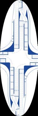
4 OVERVIEW OF THE TOOL BACKGROUND The Federal Highway Administration (FHWA) Office of Operations Research and Development developed the Capacity Analysis for Planning of Junctions (CAP-X) software to screen innovative intersection and interchange configurations. CAP-X is a sketch-level tool that was created to help users focus on more effective intersection and interchange configurations prior to conducting more demanding traffic simulations. The figure below illustrates the level of detail associated with sketch-level tools in relation to more robust methods. Level of Detail for Transportation Analysis Methods Level of Detail Screening/ Sketch Level Travel Demand Modeling HCM/ Analytical Models Simulation Models Traffic Optimization CAP-X uses the Critical Lane Volume (CLV) method to provide sketch-level capacity assessments for innovative intersection and interchange configurations using peak hour volumes. The CLV method estimates an overall intersection volume-to-capacity ratio assuming the maximum capacity of the intersection is fixed (i.e., no variance in traffic signal timings). In 2016, the Virginia Department of Transportation (VDOT) altered the CAP-X software for use in determining the congestion component in the SMART SCALE application scoring process. More information about the SMART SCALE process may be found at The VDOT innovative Intersection Committee requested that the CAP-X software tool be modified further for use in screening innovative intersection and interchange configurations in terms of congestion, pedestrians, and safety. Ultimately, the VDOT Innovative Intersection Committee envisions the tool to be useable by local jurisdictions as well as VDOT engineers and planners during the SMART SCALE application process. The tool was renamed to the VDOT Junction Screening Tool and now includes 26 unique intersection and interchange configurations, 15 of which were originally in CAP-X. PURPOSE The VDOT Junction Screening Tool is intended to aid transportation engineers and planners in Virginia with considering and screening innovative intersection and interchange configurations that address mobility and safety issues. This sketch-level tool can help identify and screen innovative intersection and interchange configurations to be evaluated for further study, analysis and design. Results are based on user inputs for turning movement volumes and lane configurations. This tool is only applicable to isolated intersections or interchanges; however, the results may be indicative of how an intersection or interchange within a corridor will operate. The results provided in the VDOT Junction Screening Tool are not meant to replicate the results that would be obtained from more detailed traffic operations, safety, and design analyses. As such, the VDOT Junction Screening Tool is intended to provide information to users that will aid them in the planning, screening, and decision-making processes used to determine which innovative intersection and interchange configurations should move forward to a more detailed analysis. SCORING SYSTEM The VDOT Junction Screening Tool provides information to users in three categories: congestion, pedestrians, and safety. Further information on the development of each category is outlined below. This tool does not prioritize any category over another and congestion is the only category dependent on user inputs. It is the user's responsibility to decide how to apply and prioritize the results from this tool. 1
5 OVERVIEW OF THE TOOL Congestion Volume-to-capacity (V/C) ratio is the primary metric used to reflect congestion when comparing configurations. V/C ratio is calculated using the CLV method with the assumption that the maximum capacity of the intersection is fixed. This calculation is dynamic and is dependent on the volume and lane configuration inputs entered into the VDOT Junction Screening Tool. This calculation does not consider signal timing, geometric, or driver behavior parameters and is not intended to replicate the calculations produced by traffic analysis tools. The user must verify the number of left-turn, through, and right-turn lanes entered for each innovative intersection or interchange configuration that is considered. Misleading results are possible if lane configurations are inconsistent across similar intersection or interchange configurations. This tool generally does not limit the number of lanes that are assigned to a particular movement. The user should also consider right-of-way (ROW) impacts and/or design requirements for an individual project when assigning lane configurations. Some of the innovative intersection or interchange configurations are divided into multiple zones, with each zone representing a location with conflicting volumes, such as a signalized intersection or crossover. The CLV method is applied individually for each zone to calculate a V/C ratio. This method determines the maximum volume per lane that must be accommodated during each signal phase and sums the critical phase volumes to determine the overall critical volume that must be accommodated by the zone. A value of 1,600 passenger cars per lane is assumed for the maximum intersection CLV. The calculated CLV for a zone is then divided by the maximum intersection CLV to determine the V/C ratio for that zone. The maximum V/C ratio of all zones that make up an innovative intersection or interchange configuration is summarized in the Results Worksheet. This V/C ratio represents the worst bottleneck in the configuration. The following table from the Highway Capacity Manual (HCM) 2010 may be used to relate the maximum V/C ratio to a description of capacity. Capacity Description Based on V/C Ratio V/C Ratio Description of Capacity < 0.85 Under capacity Near capacity At capacity > 1.0 Over capacity Source: Highway Capacity Manual 2010 Pedestrian Innovative intersection and interchange configurations were evaluated based on its potential to accommodate pedestrians considering relative impact on pedestrian safety, wayfinding, and delay. The metric developed is a static metric that is not dependent on vehicular volumes, pedestrian volumes, or the number of lanes. The potential to accommodate pedestrians is qualitatively defined as better (+), similar (blank cell), or worse (-) when compared to a conventional intersection or a traditional diamond interchange. The following components were considered in determining this rating: Safety Direction of traffic flow Number of vehicle/pedestrian conflicts Relative crosswalk lengths Wayfinding Crosswalk alignment Delay Number of crossings for a single movement Traffic signal cycle length 2
6 OVERVIEW OF THE TOOL Safety The relative safety of each innovative intersection or interchange configuration was estimated using a risk analysis based on vehicle conflict points. The three types of conflict points (crossing, merging, and diverging) were weighted based on the calculated average crash cost associated with each conflict point type. The methodology for determining the weighting system is outlined in the Safety Information worksheet. The conflict point diagram, number of conflict points, and the weighted total conflict point metric can be found in the Safety - Conflict Point Diagram section of each lane configuration worksheet. ASSUMPTIONS The following assumptions apply to the entire tool. Assumptions for a specific innovative intersection or interchange configuration are listed on the lane configuration worksheet. This tool defines an intersection configuration as a junction of two interrupted roadways, regardless of grade separation. This tool defines an interchange configuration as a junction of two roadways where one roadway remains uninterrupted. This tool is to be used to screen configurations for isolated intersections only. This tool does not consider adjacent intersections or a series of intersections in a corridor. This tool does not assume a base or existing condition. It assumes innovative configurations to be proposed conditions and compares them against each other. With the exception of the unsignalized configurations (50 Mini Roundabout, 75 Mini Roundabout, Roundabout, TWSC, Single Roundabout, Double Roundabout), each zone in a configuration is assumed to be signalized. Signal timing is not considered as part of CLV methodology. The TWSC and roundabout lane configuration worksheets do not use the CLV methodology. These worksheets use the Highway Capacity Manual (HCM ) 2010 methodology to compute the congestion metrics. Vehicule volumes, pedestrian volumes, and number of lanes were not considered as part of the pedestrian metric. Pedestrian and bicycle conflicts were not considered in the development of the conflict point diagrams. The number of lanes was not considered in the development of the conflict point diagrams. A default value of 1,600 passenger cars per lane is assumed for the maximum intersection CLV. U-turn volumes from the TMCs are treated as left-turns. This tool only analyzes U-turns that are built into an innovative intersection or interchange configuration to remove left-turning traffic from an intersection (e.g., Restricted Crossing U- Turn). If a turning movement shares a lane with the through movement, the turning volume is factored by an adjustment factor to convert it to an equivalent through movement. For right turns or left turns with no opposing right-turn and through movements, the turning volume is divided by the left- or right-turn adjustment factor. For left turns with opposing right-turn and through movements, the left-turn volume is instead multiplied by a custom left-turn factor based on the opposing volume. Custom Left-Turn Factors Opposing Volume Custom Factor < ,000 5 Sources: Guidelines for the Analysis of the Traffic Impact of Development Proposals; City of Frederick - Traffic Impact Study Guidelines 3
7 OVERVIEW OF THE TOOL If an approach has both a shared through-left lane and an exclusive left-turn lane, this approach and its opposing approach are assumed to operate with split phasing. If a movement has both a shared and an exclusive lane, the volume is distributed between the two lanes based on the number of lanes indicated. The proportion of the turning volume that is assigned to the shared lane is divided by the leftor right-turn adjustment factor to convert it to an equivalent through movement. For example, if the northbound movement has a left-turn lane and a shared left-through lane, 50% of the left-turn volume is assigned to each lane. If a right-turn movement is channelized with a receiving lane, the right-turn volume is not considered in the CLV calculations for that zone. Unless specified with the lane configuration worksheet, right-turn movements are not assumed to be channelized. For interchange configurations, it is assumed that no vehicles on the off-ramp make through movements. 4
8 LIST OF ABBREVIATIONS CAP-X CLV CGT DDI DLT EB E-W FHWA HCM Hr ICD LTAF MUT MUD NB N-E N-S N-W Parclo PC/Hr PCE PCPH PCL PMUT QR RCUT ROW RTAF SB S-E S-W SPUI TD TMC UTAF V/C VDOT Veh/Hr WB Capacity Analysis of Junctions Critical Lane Volume Continuous Green-T Diverging Diamond Interchange Displaced Left Turn Eastbound East-West Federal Highway Administration Highway Capacity Manual Hour Inscribed Circle Diameter Left-Turn Adjustment Factor Median U-Turn Michigan Urban Diamond Northbound North-East North-South North-West Partial Cloverleaf Passenger Cars Per Hour Passenger Car Equivalent Passenger Cars Per Hour Partial Cloverleaf Partial Median U-Turn Quadrant Roadway Restricted Crossing U-Turn Right-of-way Right-Turn Adjustment Factor Southbound South-East South-West Single Point Urban Interchange Traditional Diamond Turning Movement Count U-Turn Adjustment Factor Volume/Capacity Virginia Department of Transportation Vehicles per hour Westbound 1

9 INSTRUCTIONS Upon opening the tool, click the Enable Content button as shown in the security warning window. Security Warning Window This tool contains the following worksheets to screen innovative intersection and interchange configurations and report results: Input Worksheet - the user inputs general project information, traffic volumes, and adjustment factors and to select which innovative intersection and interchange configurations should be considered Lane Configuration Worksheets (29) - the user inputs lane configurations and calculates the congestion metrics using the Critical Lane Volume (CLV) methodology Results Worksheet - summarizes the congestion, pedestrian, and safety metrics for the innovative intersection and interchange configurations selected for comparison The following worksheets are also included for reference and guidance in screening innovative intersection and interchange configurations: Overview - describes the methodologies used to calculate the congestion, pedestrian, and safety metrics Safety Information - summarized the process used to develop the conflict point weighting factors used to develop the safety metric Design Considerations - provides a description of the innovative intersection and interchange configurations and provides guidance on when a configuration should be considered This tool can be used to screen innovative intersection and interchange configurations following the four steps provided below. Step 1: Enter Volume Inputs Step 2: Review and Select Intersection and Interchange Configurations for Comparison Step 3: Enter Lane Configurations (for each selected worksheet) Step 4: View and Interpret Results STEP 1: ENTER VOLUME INPUTS Input the project title and the names of the east-west roadway facility and the north-south roadway facility. This information will be automatically populated on each subsequent worksheet. This tool requires the user to input turning movement counts (TMCs) into the yellow cells on the Input Worksheet to compare innovative intersection and interchange configurations. The traffic counts may be for the current year or may be projected to a future year. If the TMC includes U-turn volumes separately, then add the U-turn volume to the left-turn volume. This tool does not analyze U-turns unless U-turns are built into an innovative intersection configuration to remove left-turning traffic from an intersection (e.g., Restricted Crossing U-Turn). Traffic Volume Demand Inputs 1

10 INSTRUCTIONS This tool uses adjustment factors to convert turning vehicles to equivalent through vehicles before calculating the CLV. Suggested values for these factors are provided in the tool; however, these values may be changed based on the typical traffic mix, driver behavior, and project location. Input the following factors into the yellow cells: Left-turn adjustment factor (LTAF): conversion of protected left- and U-turning vehicles to equivalent through vehicles Right-turn adjustment factor (RTAF): conversion of right-turning vehicles to equivalent through vehicles U-turn adjustment factor (UTAF): conversion of U-turning vehicles (rerouted through or left-turn movements) to equivalent through vehicles (this factor is only used if U-turns are built into an alternative configuration to remove left-turning traffic from an intersection) Truck to passenger car equivalent (PCE) factor: conversion of truck volume to an equivalent passenger car volume. This may be based on the HCM STEP 2. REVIEW AND SELECT INTERSECTION AND INTERCHANGE CONFIGURATIONS FOR COMPARISON Review the list of alternative intersection and interchange configurations included in this tool. Each configuration contains a link to an informational worksheet that provides guidance on when each configuration type should be considered. Indicate with a "Y" any configurations that should be considered. Indicate with an "N" any configurations that should be excluded. Use the Show/Hide Configurations button to hide the worksheets for all "N" configurations. The configurations selected for exclusion will also be hidden from the Results Worksheet. The Unhide All Configurations button may be used to unhide all worksheets. Additionally, three toggle buttons allow the user to select or unselect all intersections or interchanges. However, these toggle buttons will not hide the respective lane configuration worksheets; the user must still use the Show/Hide Configurations button. Show/Hide Lane Configuration Worksheets Provide justification by selecting an option in the drop down in the Input Worksheet for all alternative intersection and interchange configurations excluded for the screening comparison. Justification Options 2
 [Input Worksheet] Step 3.2: Enter the lane configurations [Input Worksheet and Lane Configuration Worksheets] Step 3.")
11 INSTRUCTIONS STEP 3: ENTER LANE CONFIGURATIONS Complete the following steps for the intersection and interchange configurations selected for screening in the Input Worksheet. Step 3.1: Answer the directional question (if applicable) [Input Worksheet] Step 3.2: Enter the lane configurations [Input Worksheet and Lane Configuration Worksheets] Step 3.1: Answer the Directional Questions All asymmetrical configurations contain a question that will associate a direction with a geometric feature in the configuration to correctly reference the TMCs from the Input Worksheet to the lane configuration worksheets. These questions are located on the Input Worksheet as pictured below. Example Directional Questions Directional Questions and Options: [All interchanges] Select the freeway direction from the drop-down list. EB-WB, NB-SB [Continuous Green-T] Select the direction associated with the "stem" of the T-intersection from the drop-down list. NB, SB, EB, WB [Partial Displaced Left Turn] Select the roadway with the displaced left turns. EB-WB, NB-SB [Multiple] Select the roadway with the U-turns from the drop-down list. EB-WB, NB-SB [Bowtie] Select the roadway with the roundabouts from the drop-down list. EB-WB, NB-SB [Split Intersection] Select the direction of the "split" roadway from the drop-down list. EB-WB, NB-SB [Echelon] Select the approach that shares a zone with the NB approach from the drop-down list. EB, WB [Single Loop] Select the quadrant that contains the loop from the drop-down list. N-E, N-W, S-E, S-W 3


12 INSTRUCTIONS Based on the answer provided in the directional question, the directional labels and volumes will update similar to the example figures shown below for a Traditional Diamond Interchange. The example figure and the layout of cells in the Data Input and Configuration section will not change. Example Figure Example Data Input and Configuration Layout 4


, or design requirements for an individual project.")
13 INSTRUCTIONS Step 3.2: Enter the Lane Configurations After answering the directional question for all applicable intersection and interchange configurations, enter a base number of through lanes for each travel direction on the Input Worksheet as pictured below. The number of through lanes entered here will be applied to each lane configuration worksheet. This base number may be overwritten on individual lane configuration worksheets. Turn lanes, shared lanes, and channelized lanes must still be entered in each lane configuration worksheet. Base Number of Through Lanes Then, navigate to each lane configuration worksheet to verify the overall lane configuration for each approach direction. The lane configuration refers to the number of lanes for each left-turn, through, or right-turn movement. Inputs for lane configurations should be made into all yellow cells as shown in the figure below. This step should be followed on each worksheet selected for screening. Lane Configurations Note: This tool does not consider the geometric footprint, available right-of-way (ROW), or design requirements for an individual project. The tool generally does not limit the number of lanes that may be assigned to a particular movement. However, a pop-up box will appear asking the user to confirm the number of lanes if five or more through lanes or three or more turn lanes were entered. Additionally, indicate if any shared lanes or channelized right-turn lanes are present. A right-turn lane should be identified as channelized only if a receiving lane is present and is at least 500 feet long. If a shared lane is present, count the lane only as a through lane and select "Yes" in the "Shared?" cell next to the appropriate turning movement. If an approach has one lane with a left-throughright movement, select one lane for the through movement and indicate that both the left- and right-turn movements are shared. If an exclusive turn lane is present in addition to the shared lane, enter one lane for the appropriate turning movement. Example shared-lane configurations and their respective inputs are shown below. 5


14 INSTRUCTIONS Example Shared-Lane Configurations STEP 4: VIEW AND INTERPRET RESULTS After completing Step 2, navigate to the Results Worksheet. This sheet compares the effectiveness of each alternative intersection and interchange configuration's potential to mitigate congestion, pedestrian, and safety concerns. Only the congestion metric is dependent on the inputs in Steps 1 and 2. The results shall not be interpreted until the user has performed Steps 1 and 2 on each lane configuration worksheet. The other metrics represent static values. Further descriptions of the congestion, pedestrian, and safety metrics are provided in the Overview and Safety Information tabs. These metrics do not consider signal timing parameters, geometric parameters, driver behavior parameters, available ROW, or design requirements for an individual project. It is the user's responsibility to determine how these factors may affect the results provided and decide how to apply and prioritize the results from this tool. Descriptions of each alternative intersection and interchange configuration and guidance on when each configuration type should be considered are provided in the Design Considerations worksheet. Based on the results provided in the Results Worksheet and the information provided in the Design Considerations worksheet, the user may select which configurations should be selected for further study and evaluation. 6

15 SAFETY INFORMATION The relative safety of an innovative intersection or interchange configuration was estimated by correlating crash data to assign a relative risk level associated with vehicle conflict points. The conflict points were weighted based on the calculated average crash cost associated with each conflict point type in Virginia. The methodology for determining the weighting system is outlined below. The conflict point diagram, number of conflict points, and the weighted total conflict point metric are included in the Safety - Conflict Point Diagram section of each lane configuration worksheet. PART 1: CONFLICT POINT DIAGRAM METHODOLOGY Conflict diagrams were developed for the innovative intersection and interchange configurations. Lines represent possible movements within the configuration. U-turns were only considered for innovative configurations that use U-turns to remove or relocate left-turning traffic from an intersection. Conflict points were defined as crossing, merging, or diverging conflicts at points of intersecting movements. A conflict point diagram is included in each lane configuration worksheet. An example diagram is shown below for a conventional intersection. The conflict point diagrams and total number of conflict points are independent of the number of lanes, shared lanes, or channelization of movements. Additionally, the conflict point diagrams do not consider traffic signal phasing. Merge and diverge conflicts on the freeway are included for interchange configurations. Example Conflict Diagram (Conventional Intersection) 1
16 SAFETY INFORMATION PART 2: CONFLICT POINT WEIGHTING METHODOLOGY The type, severities, and quantity of crashes that are likely to occur at each type of conflict point vary. Assumptions related to type and severity for the conflict point types were determined to allow for the comparison of configurations. A weighting system was then developed to produce a single safety metric. Four crash types were assigned to one or more conflict point types based on the likelihood of that crash type occurring. The crash types assigned to each conflict point type were as follows: Crossing Conflict Head on Angle Sideswipe - opposite direction Merging Conflict Sideswipe - same direction Diverging Conflict Sideswipe - same direction An average crash cost for an angle, head on, sideswipe - same direction, and sideswipe - opposite direction crash that occurred in Virginia between 2011 and 2015 was computed using the average crash cost by severity values from the Highway Safety Manual, 1st Edition. Average Crash Cost By Severity Crash Cost Severity Fatal (K) Disabling Injury (A) Evident Injury (B) Possible Injury (C) Property Damage (O) $4,008,885 $216,059 $79,777 $44,868 $7,428 Source: Highway Safety Manual, 1st Edition 2
17 SAFETY INFORMATION Crash Type Angle Head On Sideswipe - Same Direction Sideswipe - Opposite Direction Average Crash Cost in Virginia By Crash Type Severity Full Access Control Partial Access No Access Control All Crashes # Avg Cost # Avg Cost # Avg Cost # Avg Cost K A B $72,195 $61,648 $55,276 C $53,406 O Total K A B $242,784 $131,358 $162,816 C $146,785 O Total K A B $34,673 $28,098 $24,967 C $26,667 O Total K A B $108,807 $28,527 $55,669 C $49,679 O Total The average crash cost per conflict point type was calculated based on the average crash cost per crash type and the frequency of each crash type. These average crash costs per conflict point type were used to derive the weighting system used to assign relative risk to the conflict point types. It was determined that crashes occurring at crossing conflicts were roughly two times more costly, and therefore carry two times the risk, than crashes occurring at merging or diverging conflict points. Conflict Point Type Crossing Merging/Diverging Average Crash Cost Per Conflict Point Type Per Facility Type Full Access Control Partial Access No Access Control All Crashes Avg Cost Weight Avg Cost Weight Avg Cost Weight Avg Cost Weight $84, $64, $64, $61, $34, $28, $24, $26, Weighting System Based on Risk Factor Conflict Point Type Assigned Weight Crossing 2 Merging 1 Diverging 1 3
18 DESIGN CONSIDERATIONS Intersection Designs Bowtie Center Turn Overpass Continuous Green-T (CGT) Back to Inputs Back to Inputs Back to Inputs Description Description Description The bowtie intersection is an alternative to the MUT intersection. Left-turn movements from both roadways are removed from the main intersection and are executed via a U-turn at a roundabout on the minor roadway downstream of the main intersection. Removing the left-turn movements allows for twophase signal control. All four left-turn movements are relocated to a gradeseparated intersection using narrow ramps within the median. The left-turn traffic then descends back to ground level and merges into through traffic. Both intersections operate under two-phase signal control. Through traffic on the top side of a T-intersection is allowed to pass through the intersection without stopping. Left-turn volumes from the minor roadway must merge into the continuous lane of through traffic after completing the left turn. This design allows for three-phase signal control. The tool assumes the intersection is signalized. The intersection may be designed as unsignalized. When Should This Design Be Considered? When Should This Design Be Considered? When Should This Design Be Considered? The bowtie intersection should be considered on roadways with high through volumes on the major roadway and low through and left-turn volumes on the minor roadway. Arterials with narrow medians and limited ROW should be considered. The center turn overpass intersection should be considered at high-volume urban or suburban intersections where the major and minor roadways have similar left-turn volumes. The continuous green-t intersection should be considered at three-leg intersections with moderate to low left-turn volumes on the minor roadway, high through volumes on the major roadway, and few pedestrian crossings.

 or three-phase (partial) signal control.")
 or both roadways (full) are removed from the main intersection.")
19 DESIGN CONSIDERATIONS Intersection Designs Echelon Full/Partial Displaced Left Turn (DLT) Full/Partial Median U-Turn (MUT) Back to Inputs Back to Inputs Back to Inputs Description Description Description One approach on both the major and minor roadways is elevated to create two gradeseparated intersections of two one-way roads. Each intersection operates under two-phase signal control. Left-turning vehicles cross over to the other side of the roadway at a signalized intersection several hundred feet in advance of the main intersection. The protected left turns occur simultaneously with the opposing through movements at the main intersection, allowing for two- (full) or three-phase (partial) signal control. This design is also referred to as a Continuous Flow Intersection or Crossover Displaced Left Intersection. Left-turn movements from the major roadway (partial) or both roadways (full) are removed from the main intersection. These vehicles instead execute a U-turn at a median opening on the major roadway downstream of the main intersection. Removing the left-turn movements allows for two- (full) or three-phase (partial) signal control. This tool assumes all intersections are signalized. However, this intersection can be designed as partially unsignalized. When Should This Design Be Considered? When Should This Design Be Considered? When Should This Design Be Considered? The echelon intersection should be considered at high-volume urban or suburban intersections where the major and minor roadways have similar volumes. The displaced left turn intersection should be considered if opposing approaches have high and balanced through and left-turn volumes. The median U-turn intersection should be considered on high-speed, median-divided highways with moderate left-turn volumes on the major roadway and minor left-turn volumes on the minor roadway.


20 DESIGN CONSIDERATIONS Intersection Designs Quadrant Roadway (QR) Restricted Crossing U-Turn (RCUT) Single Loop Back to Inputs Back to Inputs Back to Inputs Description Description Description All four left-turn movements are rerouted onto a connector road in one quadrant, allowing for twophase signal control at the main intersection and threephase signal control at the intersections with the connector road. This tool assumes all intersections are signalized. However, this intersection can be designed as partially unsignalized. Minor roadway left-turn and through movements are removed from the main intersection. These vehicles turn right onto the major roadway before making a U- turn at a downstream median opening. Removing these movements allows for two-phase signal control at the main intersection. This design is also referred to as a super street intersection. This tool assumes all intersections are signalized. However, this intersection can be designed as partially or fully unsignalized. All four left-turn movements and some right-turn movements are rerouted onto a connector road in one quadrant, while the major and minor roadways are grade-separated. This design allows for three-phase signal control at the intersections with the connector road.this tool assumes all intersections are signalized. However, this intersection can be designed as fully unsignalized. When Should This Design Be Considered? When Should This Design Be Considered? When Should This Design Be Considered? The quadrant roadway intersection should be considered if an existing roadway can be used as a connection roadway or there are heavy left-turn and through volumes on the major and minor roadways. The ratio of minor road volume to total intersection volume is typically less than or equal to The restricted crossing U-turn intersection should be considered on high-speed, median-divided highways with high through and left-turn volumes on the major roadway and low through volumes on the minor roadway. The single loop intersection should be considered for roadways with low to medium left-turn volumes.


21 DESIGN CONSIDERATIONS Intersection Designs Split Intersection Mini Roundabout Roundabout Back to Inputs Back to Inputs Back to Inputs Description Description Description The split intersection separates traffic flow on the major roadway into two one-way roads with separate intersections with the minor roadway. Each intersection may operate using three-phase signal control. This configuration is similar to a traditional diamond interchange without grade separation. A roundabout is a circular unsignalized intersection in which traffic flows in one direction around a central island. Traffic entering the roundabout must yield to traffic already inside the roundabout. This tool includes mini roundabouts with a 50 foot or 75 foot inscribed diameter. A roundabout is a circular unsignalized intersection in which traffic flows in one direction around a central island. Traffic entering the roundabout must yield to traffic already inside the roundabout. This tool can accommodate roundabouts with up to two lanes in each quadrant. When Should This Design Be Considered? When Should This Design Be Considered? When Should This Design Be Considered? The split intersection should be considered for isolated, suburban intersections with high leftturn volumes or in urban areas where two-way streets can be converted to one-way streets. The split intersection may also be considered if grade separation may be needed in the future. The mini roundabout should be considered if the posted speed limit on all four approaches is 30 mph or slower and the 85th percentile speed is 35 mph or slower. The roundabout should be considered on roadways with a high percentage of turning traffic. Additional information about when roundabouts should be considered may be found on VDOT's website.
22 DESIGN CONSIDERATIONS Interchange Designs Traditional Diamond (TD) Contraflow Left Displaced Left Turn (DLT) Back to Inputs Back to Inputs Back to Inputs Description Description Description The traditional diamond interchange is a gradeseparated interchange with two intersections on the arterial. The intersections may be signalized or unsignalized. Each direction of travel on the freeway has one on-ramp and one off-ramp. The contraflow left interchange is an alternative to the traditional diamond interchange in which arterial left-turn movements cross over opposing left-turn movements into storage bays prior to the first ramp intersection. These storage bays run in the opposite direction from the adjacent through lanes. This design allows for three-phase signal control. The arterial left-turning vehicles cross over to the other side of the roadway at a signalized intersection several hundred feet in advance of the first ramp intersection. At both of the ramp intersections, the protected left turns occur simultaneously with the opposing through movements, allowing for two-phase signal control. This design is also referred to as a Continuous Flow Interchange. When Should This Design Be Considered? When Should This Design Be Considered? When Should This Design Be Considered? The traditional diamond interchange should be considered in rural and suburban areas with moderate to low ramp volumes. The contraflow left interchange should be considered on arterials with high left-turn volumes onto the freeway ramps, especially if the left-turn demand exceeds the storage capacity between the ramps. The displaced left turn intersection should be considered if there are high and balanced through volumes on the arterial, moderate to high left-turn volumes to the on-ramps, and low to moderate left-turn volumes from the offramps.


 Interchange. This tool assumes all intersections are signalized. However, this intersection can be designed as partially unsignalized.")
23 DESIGN CONSIDERATIONS Interchange Designs Diverging Diamond (DDI) Double Roundabout Michigan Urban Diamond (MUD) Back to Inputs Back to Inputs Back to Inputs Description Description Description The diverging diamond interchange is an alternative to the traditional diamond interchange where arterial traffic crosses over to the other side of the roadway in between the two ramps. This allows vehicles to turn left onto the on-ramps without crossing over opposing lanes of traffic. This design is also referred to as the double crossover diamond interchange. The double roundabout interchange is a gradeseparated interchange in which all ramps begin or end at one of two roundabouts on the arterial. This design typically allows for a narrower bridge width than the single roundabout interchange. The Michigan urban diamond interchange is a variation of the traditional diamond interchange that removes left-turn movements from the arterial intersections. These vehicles instead make U-turns at directional crossovers on frontage roads. The intersections on the arterial operate under twophase signal control. This design is also referred to as a Median U-Turn (MUT) Interchange. This tool assumes all intersections are signalized. However, this intersection can be designed as partially unsignalized. When Should This Design Be Considered? When Should This Design Be Considered? When Should This Design Be Considered? The diverging diamond interchange should be considered if there are high left-turn volumes onto and off of the freeway ramps and moderate but unbalanced arterial volumes. The double roundabout interchange should be considered if there is a high proportion of left-turns onto the freeway ramps or where there is limited queue storage between the ramp intersections. The Michigan urban diamond interchange should be considered for arterials with high through volumes and moderate to low left-turn volumes.


24 DESIGN CONSIDERATIONS Interchange Designs Partial Cloverleaf (PCL or Parclo) Single Point Urban (SPUI) Single Roundabout Back to Inputs Back to Inputs Back to Inputs Description Description Description The partial cloverleaf interchange is a gradeseparated interchange with a combination of directional ramps and loop ramps. This configuration may include up to two intersections on the arterial. The intersections may be signalized or unsignalized. The single point urban interchange is an alternative to the traditional diamond interchange in which all ramps begin or end at a single intersection on the arterial. This configuration allows for three-phase signal control. The single roundabout interchange is a gradeseparated interchange in which all ramps begin or end at a single roundabout on the arterial. When Should This Design Be Considered? When Should This Design Be Considered? When Should This Design Be Considered? The partial cloverleaf interchange should be considered if a traditional diamond interchange would result in moderate to high left-turn volumes onto or off the ramps. The single point urban interchange should be considered in urban areas with high left-turn volumes onto and off the freeway ramps or when right-of-way limitations are present. The roundabout interchange should be considered in urban areas with moderate capacity requirements or with right-of-way restrictions.
FHWA Safety Performance for Intersection Control Evaluation (SPICE) Tool
 Tool") FHWA Safety Performance for Intersection Control Evaluation (SPICE) Tool Virginia Section ITE Annual Meeting Virginia Beach June 217 Pete Jenior Kittelson & Associates, Inc. 1 Intersection Control Evaluation
FHWA Safety Performance for Intersection Control Evaluation (SPICE) Tool Virginia Section ITE Annual Meeting Virginia Beach June 217 Pete Jenior Kittelson & Associates, Inc. 1 Intersection Control Evaluation
THE FUTURE OF THE TxDOT ROADWAY DESIGN MANUAL
 THE FUTURE OF THE TXDOT ROADWAY DESIGN MANUAL Kenneth Mora, P.E. (Design Division) 10/10/2017 Table of contents 1 2 Reduction in FHWA design controlling criteria Innovative Intersection Guidance 3-7 8-42
Appendix D: Concept Screening
 Concept Description Concept #1 Route 288 Roadway Widening This concept consists of constructing a third lane on northbound and southbound Route 288 between Powhite Parkway and US 360. This improvement
ENHANCED PARKWAY STUDY: PHASE 2 CONTINUOUS FLOW INTERSECTIONS. Final Report
 Preparedby: ENHANCED PARKWAY STUDY: PHASE 2 CONTINUOUS FLOW INTERSECTIONS Final Report Prepared for Maricopa County Department of Transportation Prepared by TABLE OF CONTENTS Page EXECUTIVE SUMMARY ES-1
Chapter 4 Traffic Analysis
 Chapter 4 Traffic Analysis PURPOSE The traffic analysis component of the K-68 Corridor Management Plan incorporates information on the existing transportation network, such as traffic volumes and intersection
Innovative Intersections
 Innovative Intersections Things You Need to Know About FDOT D-7 Safety Academy October 19, 2016 Mark Doctor FHWA Resource Center Atlanta, GA HOW DO YOU FEEL??? about innovative intersections??? Why is
Evaluation of M-99 (Broad Street) Road Diet and Intersection Operational Investigation
 Road Diet and Intersection Operational Investigation") Evaluation of M-99 (Broad Street) Road Diet and Intersection Operational Investigation City of Hillsdale, Hillsdale County, Michigan June 16, 2016 Final Report Prepared for City of Hillsdale 97 North Broad
Evaluation of M-99 (Broad Street) Road Diet and Intersection Operational Investigation City of Hillsdale, Hillsdale County, Michigan June 16, 2016 Final Report Prepared for City of Hillsdale 97 North Broad
Alternative Intersection Analysis Using SIDRA INTERSECTION
 Alternative Intersection Analysis Using SIDRA INTERSECTION ITEANZ Innovative Intersections Seminar Melbourne, 5 Nov 2015 Rahmi Akçelik and Mark Besley SIDRA SOLUTIONS Presenter: David Nash TRAFFINITY sidrasolutions.com
Alternative Intersection Analysis Using SIDRA INTERSECTION
 Alternative Intersection Analysis Using SIDRA INTERSECTION ITEANZ Innovative Intersections Seminar Melbourne, 5 Nov 2015 Rahmi Akçelik and Mark Besley sidrasolutions.com youtube.com/sidrasolutions Alternative
Safety Evaluation at Innovative Geometric Designs Gilbert Chlewicki, PE Advanced Transportation Solutions
 2016 ITE Mid-Colonial District Annual Conference Wilmington, Delaware Safety Evaluation at Innovative Geometric Designs Gilbert Chlewicki, PE Advanced Transportation Solutions April 18, 2016 WHY INNOVATIVE
TRANSPORTATION ANALYSIS REPORT US Route 6 Huron, Erie County, Ohio
 TRANSPORTATION ANALYSIS REPORT US Route 6 Huron, Erie County, Ohio December 12, 2012 Prepared for: The City of Huron 417 Main Huron, OH 44839 Providing Practical Experience Technical Excellence and Client
Subject: Solberg Avenue / I-229 Grade Separation: Traffic Analysis
 MEMORANDUM Transportation Bill Troe, AICP Jason Carbee, AICP 12120 Shamrock Plaza Suite 300 Omaha, NE 68154 (402) 334-8181 (402) 334-1984 (Fax) To: Project File Date: Subject: Solberg Avenue / I-229 Grade
Truck Climbing Lane Traffic Justification Report
 ROUTE 7 (HARRY BYRD HIGHWAY) WESTBOUND FROM WEST MARKET STREET TO ROUTE 9 (CHARLES TOWN PIKE) Truck Climbing Lane Traffic Justification Report Project No. 6007-053-133, P 101 Ι UPC No. 58599 Prepared by:
I-95 Northbound at US 1 (Exit 126) Design and Study Final Report
 Design and Study Final Report") I-95 Northbound at US 1 (Exit 126) Design and Study Final Report July 2018 Prepared by: Prepared for: TABLE OF CONTENTS 1 Introduction... 1 Study Area Limits... 1 Purpose and Need of the Study... 1 Safety
I-95 Northbound at US 1 (Exit 126) Design and Study Final Report July 2018 Prepared by: Prepared for: TABLE OF CONTENTS 1 Introduction... 1 Study Area Limits... 1 Purpose and Need of the Study... 1 Safety
Traffic Impact Analysis Walton Acres at Riverwood Athletic Club Clayton, NC
 Traffic Impact Analysis Walton Acres at Riverwood Athletic Club Clayton, NC 1. TABLE OF CONTENTS INTRODUCTION...1 1.1. Site Location and Study Area...1 1.2. Proposed Land Use and Site Access...2 1.3.
Diverging Diamond Interchange and Double Crossover Intersection Vehicle and Pedestrian Performance
 Diverging Diamond Interchange and Double Crossover Intersection Vehicle and Pedestrian Performance Praveen K. Edara, Department of Civil and Environmental Engineering, Virginia Polytechnic Institute and
HCM Sixth Edition. Plus More. Rahim (Ray) Benekohal University of Illinois at Urban Champaign,
 Benekohal University of Illinois at Urban Champaign,") HCM Sixth Edition What s New in the HCM Sixth Edition Plus More Rahim (Ray) Benekohal University of Illinois at Urban Champaign, 65 th Traffic Engineering and Safety Conference October 19 20, 2016 Institute
HCM Sixth Edition What s New in the HCM Sixth Edition Plus More Rahim (Ray) Benekohal University of Illinois at Urban Champaign, 65 th Traffic Engineering and Safety Conference October 19 20, 2016 Institute
Shockoe Bottom Preliminary Traffic and Parking Analysis
 Shockoe Bottom Preliminary Traffic and Parking Analysis Richmond, Virginia August 14, 2013 Prepared For City of Richmond Department of Public Works Prepared By 1001 Boulders Pkwy Suite 300, Richmond, VA
Introduction Roundabouts are an increasingly popular alternative to traffic signals for intersection control in the United States. Roundabouts have a
 HIGH-CAPACITY ROUNDABOUT INTERSECTION ANALYSIS: GOING AROUND IN CIRCLES David Stanek, PE and Ronald T. Milam, AICP Abstract. Roundabouts have become increasingly popular in recent years as an innovative
Traffic Impact Study WestBranch Residential Development Davidson, NC March 2016
 Traffic Impact Study WestBranch Residential Development Davidson, NC March 216 TRAFFIC IMPACT STUDY FOR THE WestBranch Residential Development LOCATED IN DAVIDSON, NC Prepared For: Lennar Carolinas, LLC
PRELIMINARY DRAFT WADDLE ROAD / I-99 INTERCHANGE PROJECT ALTERNATIVE ANALYSIS FINAL TRAFFIC SUMMARY REPORT
 PRELIMINARY DRAFT WADDLE ROAD / I-99 INTERCHANGE PROJECT ALTERNATIVE ANALYSIS FINAL TRAFFIC SUMMARY REPORT Prepared by: In Association with: November 2013 EXECUTIVE SUMMARY Patton Township, in partnership
Traffic Impact Analysis Chatham County Grocery Chatham County, NC
 Chatham County Grocery Chatham County, NC TABLE OF CONTENTS 1. INTRODUCTION... 1 1.1. Location and Study Area... 1 1.2. Proposed Land Use and Access... 2 1.3. Adjacent Land Uses... 2 1.4. Existing ways...
Traffic Impact Study Little Egypt Road Development Denver, North Carolina June 2017
 Traffic Impact Study Little Egypt Road Development Denver, North arolina June 2017 N. Little Egypt Road DQ\ QDQFLQJ VDOHV RU RWKHU SHUIRUPDQFH EDVHG FULWHULD Proposed Site Driveways Site Driveway 1 TRAFFI
INNOVATIVE INTERSECTION DESIGN
 INNOVATIVE INTERSECTION DESIGN J. Eddie Valtier, P.E. ELP TP&D Director Introduction Why Do We Need To Start Looking For Innovative Intersection Designs? Congestion is worsening and traffic volumes and
METHODOLOGY. Signalized Intersection Average Control Delay (sec/veh)
") Chapter 5 Traffic Analysis 5.1 SUMMARY US /West 6 th Street assumes a unique role in the Lawrence Douglas County transportation system. This principal arterial street currently conveys commuter traffic
Chapter 5 Traffic Analysis 5.1 SUMMARY US /West 6 th Street assumes a unique role in the Lawrence Douglas County transportation system. This principal arterial street currently conveys commuter traffic
Figure 1: Vicinity Map of the Study Area
 ARIZONA TEXAS NEW MEXICO OKLAHOMA May 5, 2016 Mr. Anthony Beach, P.E. BSP Engineers 4800 Lakewood Drive, Suite 4 Waco, Texas 76710 Re: Intersection and Access Analysis along Business 190 in Copperas Cove
Existing Conditions. Date: April 16 th, Dan Holderness; Coralville City Engineer Scott Larson; Coralville Assistant City Engineer
 Date: April 16 th, 2015 To: From: Re: Dan Holderness; Coralville City Engineer Scott Larson; Coralville Assistant City Engineer Darian Nagle-Gamm, Traffic Engineering Planner Highway 6 (2 nd Street) /
Traffic Circulation Study for Neighborhood Southwest of Mockingbird Lane and Airline Road, Highland Park, Texas
 ARIZONA TEXAS NEW MEXICO OKLAHOMA February 13, 2015 Mr. Meran Dadgostar P.E., R.S. Town of Highland Park 4700 Drexel Dr. Highland Park, Texas 75205 Re: Traffic Circulation Study for Neighborhood Southwest
133 rd Street and 132 nd /Hemlock Street 132 nd Street and Foster Street MINI ROUNDABOUTS. Overland Park, Kansas
 133 rd Street and 132 nd /Hemlock Street 132 nd Street and Foster Street MINI ROUNDABOUTS Overland Park, Kansas September 1, 2017 TABLE OF CONTENTS 1. INTRODUCTION... 1 2. LITERATURE REVIEW... 1 3. CONCEPT
INDUSTRIAL BUILDING 3009 HAWTHORNE ROAD CITY OF OTTAWA TRANSPORTATION OVERVIEW REVISED. Prepared for: Canada Inc.
 INDUSTRIAL BUILDING 3009 HAWTHORNE ROAD CITY OF OTTAWA TRANSPORTATION OVERVIEW REVISED Prepared for: 7849648 Canada Inc. Octiober 1, 2015 114-598 Overview_2.doc D. J. Halpenny & Associates Ltd. Consulting
BLOSSOM AT PICKENS SIGNALIZED INTERSECTION IMPROVEMENT STUDY
 BLOSSOM AT PICKENS SIGNALIZED INTERSECTION IMPROVEMENT STUDY Class Project Report for ECIV 542 Traffic Engineering Submitted by Omor Sharif Muchun Song Narges Kaveshgar Quyen Pham Chih-Yao Lin Submission
TRAFFIC IMPACT ANALYSIS
 TRAFFIC IMPACT ANALYSIS FOR THE CHAMPAIGN UNIT#4 SCHOOL DISTRICT PROPOSED HIGH SCHOOL (SPALDING PARK SITE) IN THE CITY OF CHAMPAIGN Final Report Champaign Urbana Urbanized Area Transportation Study 6/24/2014
INTERSECTION CONTROL NOVEMBER 2018
 INTERSECTION CONTROL NOVEMBER 2018 ICE OVERVIEW AGENDA Why ICE? When ICE is Required? Applicability and Process 2 AVAILABLE RESOURCES http://www.fdot.gov/traffic/trafficservices/intersection_operations.shtm
Module 3 Developing Timing Plans for Efficient Intersection Operations During Moderate Traffic Volume Conditions
 Module 3 Developing Timing Plans for Efficient Intersection Operations During Moderate Traffic Volume Conditions CONTENTS (MODULE 3) Introduction...1 Purpose...1 Goals and Learning Outcomes...1 Organization
7.0 FREEWAYS CONGESTION HOT SPOT PROBLEM & IMPROVEMENT PROJECT ANALYSIS & DEFINITION
 7.0 FREEWAYS CONGESTION HOT SPOT PROBLEM & IMPROVEMENT PROJECT ANALYSIS & DEFINITION 7.1 INTRODUCTION & METHODOLOGY FEASIBILITY REPORT Congestion hot spot problem locations have been assessed using the
Project Report. South Kirkwood Road Traffic Study. Meadows Place, TX October 9, 2015
 Meadows Place, TX October 9, 2015 Contents 1 Introduction... 1 2 Data Collection... 1 3 Existing Roadway Network... 2 4 Traffic Volume Development... 2 5 Warrant Analysis... 3 6 Traffic Control Alternative
Northwest Corridor Project Interchange Modification, Interchange Justification and System Analysis Report Reassessment (Phase I)
") Northwest Corridor Project Interchange Modification, Interchange Justification and System Analysis Report Reassessment (Phase I) Introduction The Georgia Department of Transportation (GDOT) prepared a
Northwest Corridor Project Interchange Modification, Interchange Justification and System Analysis Report Reassessment (Phase I) Introduction The Georgia Department of Transportation (GDOT) prepared a
ORANGE COUNTY PUBLIC WORKS TRAFFIC INVESTIGATIONS
 ORANGE COUNTY PUBLIC WORKS TRAFFIC INVESTIGATIONS STAFF REPORT OF: January 6, 2019 SUPERVISORIAL DISTRICT: 5 SUBJECT: LOCATION: INVESTIGATOR: O Neill Drive at Roanoke Drive; Ladera Ranch; TB 922-E6 Clever
HIGHWAY CAPACITY MANUAL
 HISTORY OF THE HIGHWAY CAPACITY MANUAL TexITE - Houston Chapter November 10, 2010 Michael Y. Ereti City of Houston Department of Public Works & Engineering THE NEW GUY (Michael Ereti) Consultant (10 years)
DUNBOW ROAD FUNCTIONAL PLANNING
 DUNBOW ROAD FUNCTIONAL PLANNING Final Report August 3, 216 #31, 316 5th Avenue NE Calgary, AB T2A 6K4 Phone: 43.273.91 Fax: 43.273.344 wattconsultinggroup.com Dunbow Road Functional Planning Final Report
Appendix B: Forecasting and Traffic Operations Analysis Framework Document
 Existing Conditions Report - Appendix Appendix B: Forecasting and Traffic Operations Analysis Framework Document This document defines the methodology and assumptions that will be used in the traffic forecasting
Proposed Action, Purpose and Need Technical Memorandum
 Proposed Action, Purpose and Need Technical Memorandum MoPac (State Loop 1) Intersections, Austin District From North of Slaughter Lane to South of La Crosse Avenue CSJ: 3136-01-015 Travis County, Texas
Route 28 (South Orleans Road)/Route 39 (Harwich Road)/Quanset Road Intersection
/Route 39 (Harwich Road)/Quanset Road Intersection") TRAFFIC FEASIBILITY STUDY Route 28 (South Orleans Road)/Route 39 (Harwich Road)/Quanset Road Intersection Orleans, Massachusetts Prepared for: Town of Orleans Prepared by: Fay, Spofford & Thorndike, LLC
TRAFFIC FEASIBILITY STUDY Route 28 (South Orleans Road)/Route 39 (Harwich Road)/Quanset Road Intersection Orleans, Massachusetts Prepared for: Town of Orleans Prepared by: Fay, Spofford & Thorndike, LLC
PEDESTRIAN ACCOMMODATIONS DPS 201 AT INTERCHANGES
 PEDESTRIAN ACCOMMODATIONS DPS 201 AT INTERCHANGES UNDERSTANDING THE ISSUES Intersections of freeway ramp terminals at crossroads are the most critical components of an interchange Challenge: balance mobility
INNOVATIVE INTERSECTION SOLUTIONS. Jay Bockisch, PE, PTOE Senior Associate
 INNOVATIVE INTERSECTION SOLUTIONS Jay Bockisch, PE, PTOE Senior Associate INNOVATIVE INTERSECTION SOLUTIONS Innovative intersection overview Case studies Continuous flow intersection Modern roundabouts
THIS PAGE LEFT BLANK INTENTIONALLY
 GA SR 25 Spur at Canal Road Transportation Impact Analysis PREPARED FOR GLYNN COUNTY, GEORGIA 1725 Reynolds Street, Suite 300 Brunswick, Georgia 31520 PREPARED BY 217 Arrowhead Boulevard Suite 26 Jonesboro,
Innovative Intersections Presented by: Matt Crim P.E., PTOE Stantec Consulting Services Inc. October 29, 2015
 Innovative Intersections Presented by: Matt Crim P.E., PTOE Stantec Consulting Services Inc. October 29, 2015 1 Traditional Intersections Traditional Intersections allow left turns from all approaches.
NO BUILD TRAFFIC OPERATIONS
 3. 23 NO BUILD TRAFFIC OPERATIONS This section addresses the operations of the transportation system and details how it would be expected to function under year 23 No Build conditions with the projected
Operational Performance Comparison between Three Unconventional Intersection Designs: Left-turn Bypass, Diverging Flow and Displaced Left-turn
 Ninth LACCEI Latin American and Caribbean Conference (LACCEI 2011), Engineering for a Smart Planet, Innovation, Information Technology and Computational Tools for Sustainable Development, August 3-5, 2011,
Walmart (Store # ) 60 th Street North and Marion Road Sioux Falls, South Dakota
 60 th Street North and Marion Road Sioux Falls, South Dakota") Walmart (Store #4865-00) 60 th Street North and Marion Road Sioux Falls, South Dakota Prepared for: Wal-Mart Stores, Inc. Bentonville, Arkansas Prepared by: Kimley-Horn and Associates, Inc. ã2013 Kimley-Horn
Walmart (Store #4865-00) 60 th Street North and Marion Road Sioux Falls, South Dakota Prepared for: Wal-Mart Stores, Inc. Bentonville, Arkansas Prepared by: Kimley-Horn and Associates, Inc. ã2013 Kimley-Horn
Traffic Impact Study. Westlake Elementary School Westlake, Ohio. TMS Engineers, Inc. June 5, 2017
 TMS Engineers, Inc. Traffic Impact Study Westlake Elementary School Westlake, Ohio June 5, 2017 Prepared for: Westlake City Schools - Board of Education 27200 Hilliard Boulevard Westlake, OH 44145 TRAFFIC
Technical Memorandum TRAFFIC IMPACT STUDY. RIDLEY ROAD CONVENIENCE STORE Southampton County, VA. Prepared for: Mr. David Williams.
 Technical Memorandum TRFFIC IMPCT STUDY RIDLEY ROD CONVENIENCE STORE Southampton County, V Prepared for: Mr. David Williams By: Charles Smith, P.E., PTOE EPR Charlottesville, V July 2014 1 TBLE OF CONTENTS
ALLEY 24 TRAFFIC STUDY
 ALLEY 24 TRAFFIC STUDY in City of Frostburg, Maryland January 2013 3566 Teays Valley Road Hurricane, WV Office: (304) 397-5508 www.denniscorporation.com Alley 24 Traffic Study January 2013 Frostburg, Maryland
USA Parkway Traffic Operations Analysis, Roundabout Option. Pedro Rodriguez, NDOT; Bryan Gant, Jacobs; Randy Travis, NDOT
 Technical Memorandum TO: Hoang Hong, NDOT DATE: September 21, 2012 FROM: SUBJECT: COPIES: John Karachepone, Jacobs USA Parkway Traffic Operations Analysis, Pedro Rodriguez, NDOT; Bryan Gant, Jacobs; Randy
INTERSECTION SAFETY STUDY State Route 57 / Seville Road
 INTERSECTION SAFETY STUDY State Route 57 / Seville Road City of Wadsworth, Medina County, Ohio Prepared For: City of Wadsworth Engineering Department 120 Maple Street Wadsworth, OH 44281 Prepared By: GPD
FINAL DESIGN TRAFFIC TECHNICAL MEMORANDUM
 FINAL DESIGN TRAFFIC TECHNICAL MEMORANDUM July 2014 FINAL (SR 43) Project Development and Environment Study From State Road 60 (Adamo Drive) to I-4 (SR 400) Hillsborough County, Florida Work Program Item
Operational & Geometrical Analysis Technical Memorandum
 I-395 Southbound between Duke Street & Edsall Road: Congestion Relief Feasibility Study Operational & Geometrical Analysis Technical Memorandum Task Order #92 Prepared by: July 17, 2012 Rummel, Klepper
Donahue Drive Corridor Traffic Operational Evaluation
 Donahue Drive Corridor Traffic Operational Evaluation PREPARED FOR: THE CITY OF AUBURN PREPARED BY: JANUARY 2007 Donahue Drive Corridor Study--Auburn, Alabama TABLE OF CONTENTS Introduction... 1 Background
I-264 CORRIDOR EVALUATION STUDY. September 7, 2016 Eric Stringfield VDOT Planning Director Chris Lawrence AECOM Senior Transportation Engineer
 I-264 CORRIDOR EVALUATION STUDY September 7, 2016 Eric Stringfield VDOT Planning Director Chris Lawrence AECOM Senior Transportation Engineer Study Overview Interchange Locations Study Context Follow-up
REDEVELOPMENT TRAFFIC IMPACT STUDY
 REDEVELOPMENT TRAFFIC IMPACT STUDY For Wendy s Parker, Colorado January 215 Prepared for: Sterling Design Associates, LLC 29 W. Littleton Boulevard #3 Littleton, Colorado 812 Prepared by: 1233 Airport
Offset Single Point Interchange I-25 at Rio Bravo Boulevard Albuquerque, New Mexico
 Offset Single Point Interchange I-25 at Rio Bravo Boulevard Albuquerque, New Mexico INSTITUTE OF TRANSPORTATION ENGINEERS 2016 WESTERN DISTRICT MEETING JULY 11, 2016 7/11/2016 1 Project Vicinity Map 7/11/2016
Glenn Avenue Corridor Traffic Operational Evaluation
 Glenn Avenue Corridor Traffic Operational Evaluation PREPARED FOR: THE CITY OF AUBURN PREPARED BY: DECEMBER 2007 Glenn Avenue Corridor Study--Auburn, Alabama TABLE OF CONTENTS Introduction... 1 Background
Grade Separated Intersection
 Grade Separated Intersection Lecture Notes in Transportation Systems Engineering Prof. Tom V. Mathew Contents 1 Overview 1 2 Classification of Intersection 2 2.1 Grade Separated Intersection...........................
Traffic Academy: IJS & IMS FAQ/RULES OF THUMB
 FAQ/RULES OF THUMB HCS intersection analysis criteria See LDM Figure 401-14aE Cycle lengths between 60 to 120 seconds No impractical phases, i.e., 1 second green time Yellow + All Red must be no less than
TRAFFIC IMPACT STUDY CRITERIA
 Chapter 6 - TRAFFIC IMPACT STUDY CRITERIA 6.1 GENERAL PROVISIONS 6.1.1. Purpose: The purpose of this document is to outline a standard format for preparing a traffic impact study in the City of Steamboat
Traffic Impact Study. Roderick Place Columbia Pike Thompson s Station, TN. Transportation Group, LLC Traffic Engineering and Planning
 F i s c h b a c h Transportation Group, LLC Traffic Engineering and Planning Traffic Impact Study Roderick Place Columbia Pike Thompson s Station, TN Prepared March 2016 Ms. Gillian L. Fischbach, P.E.,
Chapter 5 DATA COLLECTION FOR TRANSPORTATION SAFETY STUDIES
 Chapter 5 DATA COLLECTION FOR TRANSPORTATION SAFETY STUDIES 5.1 PURPOSE (1) The purpose of the Traffic Safety Studies chapter is to provide guidance on the data collection requirements for conducting a
List of Attachments. Location Map... Site Plan... City of Lake Elsinore Circulation Element... City of Lake Elsinore Roadway Cross-Sections...
 List of Attachments Exhibits Location Map... Site Plan... City of Lake Elsinore Circulation Element... City of Lake Elsinore Roadway Cross-Sections... Existing Lane Geometry and Traffic Controls... Existing
TRAFFIC SIGNAL WARRANT STUDY
 TRAFFIC SIGNAL WARRANT STUDY 5 th STREET & ENCHANTED PINES DRIVE JANUARY 2013 TRAFFIC OPERATIONS ENGINEERING SERVICES/PUBLIC WORKS DEPARTMENT TABLE OF CONTENTS INTERSECTION LOCATION MAP ii INTRODUCTION
INTERSECTION SAFETY AUDIT: STH 16/67 AND CTH Z
 WISCONSIN DEPARTMENT OF TRANSPORTATION INTERSECTION SAFETY AUDIT: STH 16/67 AND CTH Z OCONOMOWOC, WI WISCONSIN DEPARTMENT OF TRANSPORTATION INTERSECTION SAFETY AUDIT: STH 16/67 AND CTH Z OCONOMOWOC, WI
Traffic Study North Shore School District 112
 Traffic Study North Shore School District 112 Proposed Expansion of Northwood Junior High School Prepared By: May 1, 2015 1. Introduction Kenig, Lindgren, O Hara, Aboona, Inc. (KLOA, Inc.) has been retained
TRANSPORTATION IMPACT STUDY PROPOSED RIVERFRONT 47 MIXED USE DEVELOPMENT
 November 2016 TRANSPORTATION IMPACT STUDY PROPOSED RIVERFRONT 47 MIXED USE DEVELOPMENT & Aspinwall Borough, Sharpsburg Borough & O Hara Township, Allegheny County, Pennsylvania Prepared for: Riverfront
5858 N COLLEGE, LLC N College Avenue Traffic Impact Study
 5858 N COLLEGE, LLC nue Traffic Impact Study August 22, 2016 Contents Traffic Impact Study Page Preparer Qualifications... 1 Introduction... 2 Existing Roadway Conditions... 5 Existing Traffic Conditions...
CITY OF OAKLAND. 27th Street Bikeway Feasibility and Design. Final Report (v3) March 23, Kimley-Horn and Associates, Inc.
 March 23, Kimley-Horn and Associates, Inc.") CITY OF OAKLAND 27th Street Bikeway Feasibility and Design Final Report (v3) March 23, 2007 PREPARED BY: Kimley-Horn and Associates, Inc. Table of Contents 1. Introduction 3 2. 27 th Street/Bay Place Corridor
CITY OF OAKLAND 27th Street Bikeway Feasibility and Design Final Report (v3) March 23, 2007 PREPARED BY: Kimley-Horn and Associates, Inc. Table of Contents 1. Introduction 3 2. 27 th Street/Bay Place Corridor
Low Level Road Improvements Traffic Analysis. Report
 Low Level Road Improvements Traffic Analysis Report June, 22 Table of Contents. INTRODUCTION.... LOW LEVEL ROAD PROJECT....2 STUDY AREA....2. West-End Corridor Improvements... 2.2.2 East-End Corridor Improvements...
HILTON GARDEN INN HOTEL HOTEL EXPANSION 2400 ALERT ROAD, OTTAWA TRANSPORTATION BRIEF. Prepared for:
 HILTON GARDEN INN HOTEL HOTEL EXPANSION 2400 ALERT ROAD, OTTAWA TRANSPORTATION BRIEF Prepared for: Bona Building & Management Co. Ltd. Place Vanier, 333 North River Road Vanier, Ontario K1L 8B9 October
Roundabout Feasibility Memorandum
 Roundabout Feasibility Memorandum To From Gwen Pipkin Bill Howell Date June 18, 2013 Subject Roundabout Feasibility Study SR 29 PD&E Study From Oil Well Road to SR 82 Collier County, FL FPID 417540-1-22-01
MEETING FACILITY 2901 GIBFORD DRIVE CITY OF OTTAWA TRANSPORTATION BRIEF. Prepared for: Holiday Inn Express 2881 Gibford Drive Ottawa, ON K1V 2L9
 MEETING FACILITY 2901 GIBFORD DRIVE CITY OF OTTAWA TRANSPORTATION BRIEF Prepared for: Holiday Inn Express 2881 Gibford Drive Ottawa, ON K1V 2L9 December 18, 2012 112-566 Brief_1.doc D. J. Halpenny & Associates
TABLE OF CONTENTS 1. INTRODUCTION 2. TRAFFIC ENGINEERING FUNDAMENTALS 9. SYSTEM CONTROL 3. DATA COLLECTION 4. SIGNAL PHASING 10. SPECIAL OPERATIONS
 TABLE OF CONTENTS 1. INTRODUCTION 2. TRAFFIC ENGINEERING FUNDAMENTALS A. Volume, Demand, and Capacity 2-1 B. Performance Measures 2-7 C. Critical Lane Volume Analysis 2-9 3. DATA COLLECTION 4. SIGNAL PHASING
TRAFFIC STUDY GUIDELINES Clarksville Street Department
 TRAFFIC STUDY GUIDELINES Clarksville Street Department 9/1/2009 Introduction Traffic studies are used to help the city determine potential impacts to the operation of the surrounding roadway network. Two
Traffic Signal Design
 Traffic Signal Design Instructor: S. M. Mahdi Amiripour m.amiripour@gmail.com 2 Introduction Intersection is an area shared by two or more roads Designated for the vehicles to turn to different directions
Main-McVay Transit Study: Phase 2 Options Definition and High Level Constraints Evaluation
 Main-McVay Transit Study: Phase 2 Options Definition and High Level Constraints Evaluation APRIL 2016 A collaborative study between: For Additional Information or to Comment If you would like additional
Defining Purpose and Need
 Advanced Design Flexibility Pilot Workshop Session 4 Jack Broz, PE, HR Green May 5-6, 2010 Defining Purpose and Need In your agency s project development process, when do design engineers typically get
CITY OF SASKATOON COUNCIL POLICY
 ORIGIN/AUTHORITY Clause 1, Report No. 1-1980 and Clause 4, Report No. 22-1990 of the Works and Utilities Committee; Clause 6, Report No. 17-2004 of the Planning and Operations Committee; and Clause D5,
Chapter Capacity and LOS Analysis of a Signalized I/S Overview Methodology Scope Limitation
 Chapter 37 Capacity and LOS Analysis of a Signalized I/S 37.1 Overview The Highway Capacity Manual defines the capacity as the maximum howdy rate at which persons or vehicle can be reasonably expected
OTTAWA TRAIN YARDS PHASE 3 DEVELOPMENT CITY OF OTTAWA TRANSPORTATION IMPACT STUDY. Prepared for:
 OTTAWA TRAIN YARDS PHASE 3 DEVELOPMENT CITY OF OTTAWA TRANSPORTATION IMPACT STUDY Prepared for: The Ottawa Train Yards Inc. 223 Colonnade Road South, Suite 212 Nepean, Ontario K2E 7K3 January 17, 2012
Transportation Impact Study for Abington Terrace
 Transportation Impact Study for Abington Terrace Abington Township, Montgomery County, PA Sandy A. Koza, P.E., PTOE PA PE License Number PE059911 Prepared by McMahon Associates, Inc. 425 Commerce Drive,
Updated Roundabout Analysis Methodology
 Updated Roundabout Analysis Methodology In 1998, the Transportation Planning Analysis Unit (TPAU) working as part of the Roundabout Task Group selected the interim roundabout methodologies of the SIDRA
TECHNICAL MEMORANDUM VDOT Central Region On Call Task Order
 Kittelson & Associates, Inc. T R A N S P O R T A T I O N E N G I N E E R I N G / P L A N N I N G 1850 Centennial Park Drive, Suite 130, 20191 P 703-885-8970 F 703-885-8971 TECHNICAL MEMORANDUM VDOT Central
Harrah s Station Square Casino
 Transportation Analysis Harrah s Station Square Casino Pittsburgh, Pennsylvania Submitted To: City of Pittsburgh and Pennsylvania Gaming Control Board Prepared By: DKS Associates GAI Consultants December
University Hill Transportation Study Technical Memorandum Alternatives Modeling and Analysis May 2007
 Technical Memorandum May 2007 Syracuse Metropolitan Transportation Council Edwards and Kelcey with Wallace Roberts and Todd Alta Planning and Design CONTENTS SECTION ONE- INTRODUCTION...1 SECTION TWO-
Florida s Intersection Safety Implementation Plan (ISIP)
") Florida Department of TRANSPORTATION Florida s Intersection Safety Implementation Plan (ISIP) Alan El-Urfali, PE State Traffic Engineering and Operations Office March 28, 2017 Intersection Safety Implementation
Florida Department of TRANSPORTATION Florida s Intersection Safety Implementation Plan (ISIP) Alan El-Urfali, PE State Traffic Engineering and Operations Office March 28, 2017 Intersection Safety Implementation
Modern Roundabouts: a guide for application
 Modern Roundabouts: a guide for application Kentucky Community Transportation Innovation Academy 2005 The contents of this booklet reflect the views of the authors who are responsible for the facts and
Troutbeck Farm Development
 Troutbeck Farm Development Willistown Township, Chester County PA For Submission To: Willistown Township Last Revised: October, 4 TPD# INLM.A. 5 E. High Street Suite 65 Pottstown, PA 9464 6.36.3 TPD@TrafficPD.com
Design Traffic Technical Memorandum
 State Road 7 Extension PD&E Study Design Traffic Technical Memorandum Palm Beach County, FL October 2010 State Road 7 Extension PD&E Study Design Traffic Technical Memorandum Palm Beach County, FL Prepared
Capital Region Council of Governments
 March 23, 2018 Capital Region Council of Governments PROJECT CONCEPT REPORT Realignment of Swamp and Northfield Road s approaches to Route 44 (Boston Turnpike) Town of Coventry SUMMARY: The Town of Coventry
MUTCD Part 6G: Type of Temporary Traffic Control Zone Activities
 MUTCD Part 6G: Type of Temporary Traffic Control Zone Activities 6G.01 Typical Applications Each temporary traffic control (TTC) zone is different. Many variables, such as location of work, highway type,
Chapter 5 5. INTERSECTIONS 5.1. INTRODUCTION
 Chapter 5 5. INTERSECTIONS 5.1. INTRODUCTION Intersections are the physical component of the roadways where two highways intersect. They are the most complex element of roadways, since it requires more
Complete Street Analysis of a Road Diet: Orange Grove Boulevard, Pasadena, CA
 Complete Street Analysis of a Road Diet: Orange Grove Boulevard, Pasadena, CA Aaron Elias, Bill Cisco Abstract As part of evaluating the feasibility of a road diet on Orange Grove Boulevard in Pasadena,
OFFICE/RETAIL DEVELOPMENT 1625 BANK STREET OTTAWA, ONTARIO TRANSPORTATION BRIEF. Prepared for: Canada Inc.
 OFFICE/RETAIL DEVELOPMENT 1625 BANK STREET OTTAWA, ONTARIO TRANSPORTATION BRIEF Prepared for: 9402209 Canada Inc. December 15, 2015 115-625 Report_2.doc D. J. Halpenny & Associates Ltd. Consulting Transportation