Blackheath Station to Junction Rock Loop (via Grand Canyon and Popes
|
|
|
- Baldwin White
- 6 years ago
- Views:
Transcription


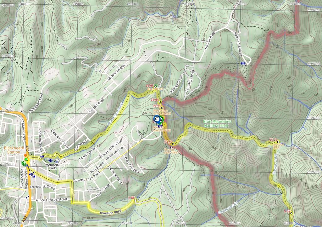
1 Blackheath Station to Junction Rock Loop (via Grand Canyon and Popes 8 hrs 30 mins 18.2 km Circuit Hard track m This circuit starts in Blackheath and heads down into the Grand Canyon and Rodriguez Pass. The track goes through a wide variety of ecosystems and changing views along the way. An interesting part of this walk is the change in mood of the cliffs that surround the Grose Valley as the light conditions change throughout the day. 1065m 361m Blue Mountains National Park Maps, text & images are copyright wildwalks.com Thanks to OSM, NASA and others for data used to generate some map layers.

2 Neates Glen Before You walk Neates Glen, Blue Mountains NP, is a deep little valley with a creek running through it. Neates Glen is part of the Grand Canyon Track and offers a nice sample of rainforest before entering the Grand Canyon itself. Bushwalking is fun and a wonderful way to enjoy our natural places. Sometimes things go bad, with a bit of planning you can increase your chance of having an ejoyable and safer walk. Before setting off on your walk check Rotunda The Rotunda, Blue Mountains NP, is an area on Greaves Creek where the cliff has been carved out to form an overhang, over a sand beach within the Grand Canyon. The Rotunda is a great area for a rest and a snack, especially on a hot day. 1) Weather Forecast (BOM Central Tablelands District) 2) Fire Dangers (Central Ranges, Greater Sydney Region) 3) Park Alerts (Blue Mountains National Park) 4) Research the walk to check your party has the skills, fitness and equipment required 5) Agree to stay as a group and not leave anyone to walk solo Beauchamp Falls Think before you TREK Beauchamp Falls, Blue Mountains NP, is a beautiful set of falls, split by the rock in the centre of the creek. The falls are created by Greaves Creek, which comes out of the Grand Canyon, above. The falls are approximately 10m tall, with rocks at the base. The 'Think before you TREK' program developed by NSW Police & NPWS promotes the benefits of planning ahead for your bushwalking trip by using an easy to remember acronym: Junction Rock Junction Rock, Blue Mountains NP, is a rock situated in the middle of the Govetts Leap Brook and Govetts Creek junction. The rock is signposted, giving directions to Evans Lookout, Neates Glen, Acacia Flats and the Blue Gum Forest. Junction Rock is a great place for lunch and a swim in summer. Govetts Leap (falls) Govetts Leap, is a waterfall in the Blue Mountains National Park. The fall is fed by Govetts Leap Brook which runs over the cliff into the Grose Valley. The falls are best viewed from Govetts Leap and Barrow Lookouts. Leap is a scots dialect word for cataract or waterfall. Govetts Leap Lookout Govetts Leap Lookout is named after the first European man to have enjoyed this view, William Govett, as an assistant surveyor in June Govetts Leap Lookout offers wonderful views over the Grose Valley and the spectacular Bridal Falls. The word `leap` is an old Scottish word meaning waterfall. The lookout is easily accessed from the car park, there are also toilets and picnic shelters nearby. adequate supplies of food, water, navigation and first T Take aid equipment. your planned route and tell friends and family when R Register you expect to return. beacon (PLB's) should be carried on walks with E Emergency significant gaps in mobile coverage (check terrain profile). to your planned route and follow the map and walking K Keep trails. Topo Maps The maps provided on wildwalks are helpful, but there are times where you may need maps covering a broader area. Maps that cover this walk include; 1: Map Series:89301S KATOOMBA, 89301N MOUNT WILSON 1: Map Series:8930 KATOOMBA Grade This walk has been graded using the AS The overall grade of the walk is dertermined by the highest classification along the whole track. 4 Grade 4/6 Hard track Length 18.2 km Circuit Time 8 hrs 30 mins Quality of track Rough track, where fallen trees and other obstacles are likely (4/6) Signs Minimal directional signs (4/6) Experience Required Some bushwalking experience recommended (3/6) Weather Storms may impact on navigation and safety (3/6) Infrastructure Limited facilities (such as cliffs not fenced, significant creeks not bridged) (4/6)
3 Are you ready to have fun? Please ensure you and your group are well prepared and equipped for all possible hazards and delays. Check park closures, weather information and Fire Danger Rating before setting out. Optional side trips and alternate routes noted are not included in this walks overall grade, length or time estimate. Please allow extra time for resting and exploring areas of interest. The authors, staff and owners of wildwalks take care in preparing this information but will not accept responsibility for any inconvenience, loss or injury you may experience. Please take care, have fun - Happy Walking. Getting there You can get to Blackheath Station (gps: , ) by car, train or bus. Car: There is free parking available. This is a circuit, so you will finish back at the start. Find up to date and more information inlcuding; travel directions, weather, park closures and walker feedback at 0 Blackheath Station (2.9 km 52 mins) From the top of the station steps, this walk heads towards the Great Western Highway and Gardners Inn. The walk turns right down a flight of stairs, then turns left across the Great Western Highway at the pedestrian crossing. Turn right: From the pedestrian crossing, this walk heads towards Gardners Inn, keeping the road to the right. The walk continues along the footpath, turning left opposite the Ivanhoe Hotel, onto Govetts Leap Rd. The walk continues down Govetts Leap Rd to the intersection with Prince Edward St. Continue straight: From the intersection, this walk heads west along Govetts Leap Rd for a block, to the intersection with Boreas St. This walk turns right, down Boreas St to the intersection with Braeside St. Turn left: From the intersection, this walk follows the green signpost to 'Braeside Walk' along the houses on the right-hand of Braeside Street. This walk turns right at the 'Braeside Walk' sign. The walk continues for approximately 70m to the intersection with another service trail. Continue straight: From the intersection, this walk heads down the management track, to the signposted intersection after a parking area on the left Int. Braeside Service Trail and Braeside Picnic Ar (1.9 km 36 mins) Veer right: From the 'Braeside Walk' signposted intersection, this walk leaves the 'Braeside Walk' sign behind on the left as it continues along the service trail towards a waterfall. The track quickly swings left, passing the waterfall (on the left of the track) and continuing up the hill for approximately 400m. The track then tends right for approximately 100m, where is passes a service trail (which heads north). This walk continues south for approximately 600m to a large intersection. Continue straight: From the intersection, this walk heads towards the road, passing a house on the left. The walk continues along James Rd to then turn left onto Evans Lookout Rd. The road tends right, to then pass Victoria Rd on the right. Shortly after Victoria Rd, this walk comes to the Bush Rock Cafe (now closed) on the left. Continue straight: From the Bush Rock Cafe(now closed), this walk heads along the road leaving the cafe behind on the left. The track continues down the road for a short time, passing Somerset Ave on the left, to then come to Neates Glen car park on the right Neates Glen car park (640 m 18 mins) Veer right: From Neates Glen car park, this walk heads down the stairs following the 'Grand Canyon Track' signs. The track zigzags many times down the hillside, with the surrounding vegetation becoming more like a rainforest, before the track comes to a railing. From this railing, the track winds down more stairs to a second railing that crosses over a creek. The track continues to wind down the right side (with creek on the left) of the canyon. The track follows the creek down past a few mossy overhangs of rock to cross a boardwalk bridge before the canyon opens up. The canyon opens onto a densely vegetated area which leads the track to a creek crossing and a sign pointing back up to 'Neates Glen carpark ' Neates Glen Neates Glen, Blue Mountains NP, is a deep little valley with a creek running through it. Neates Glen is part of the Grand Canyon Track and offers a nice sample of rainforest before entering the Grand Canyon itself Neates Glen car park sign (540 m 14 mins) Continue straight: From the sign, this walk heads away from the creek and car park, following a short section of a rock shelf to round the corner of the hill. The track contours around the hill for a little while passing under a few rock overhangs, before winding steeply down the hill into the canyon. The track heads down the cliffs by stairs to a signposted intersection in front of a sandy rock overhang, the Rotunda Rotunda The Rotunda, Blue Mountains NP, is an area on Greaves Creek where the cliff has been carved out to form an overhang, over a sand beach within the Grand Canyon. The Rotunda is a great area for a rest and a snack, especially on a hot day Rotunda (1.6 km 45 mins) Turn right: From the intersection, this walk follows the sign to 'Evans Lookout', winding around the side of the canyon under the rock overhangs. The track soon passes through a small rockfall tunnel, and then passes behind a waterfall to continue around the railed canyon track for approximately 500m, coming to a railing bridge in front of another waterfall. Continue straight: From the waterfall, this walk continues to contour around the canyon wall, keeping it on the right of the track. The track does so for quite some time before winding down deeper into the canyon after rounding a hill. The track winds down to a signposted intersection. From here, the track crosses the creek a few times before turning left at a rock overhang then crossing the creek again. The track quickly winds through the creek before passing over a bridge and continuing down the canyon. After approximately 200m, the track winds past a pool in the creek to then come to a signposted rock in a creek Int. Grand Canyon and Rodriguez Pass Tracks (380 m 16 mins) Turn right: From the intersection, the walk follows the signs to 'Rodriguez Pass' around the canyon side, with the creek on the left. After about 200m, the track crosses the creek. The walk follows the white arrows painted on the rocks winding down between, around and under large boulders for approximately 100m. The track then heads out of the pass, keeping close to the cliff line before winding down the hill to Beauchamp Falls Beauchamp Falls Beauchamp Falls, Blue Mountains NP, is a beautiful set of falls, split by the rock in the centre of the creek. The falls are created by Greaves Creek, which comes out of the Grand Canyon, above. The falls are approximately 10m tall, with rocks at the base Beauchamp Falls (1.8 km 58 mins) Continue straight: From Beauchamp Falls, this walk heads down the hill keeping the valley on the right. The track winds through and around boulders to then meander with the hillside. The track winds for some time before descending more steeply, passing a section of rock overhangs which litter the ground with blocks of sandstone. The track passes this area and continues more steeply to a railed section of stairs which drop to a creek, which it crosses to the other side. Continue straight: From the creek bank, this walk crosses to the other side of the creek. The track then turns left, heading downstream, following blue signposts and white arrows down the valley. The track soon passes a boulder with a large plank underneath it, set up as a seat, before passing a large mossy boulder. Approximately 300m on, the track passes another large mossy boulder with a white arrow at the bottom of the stairs. The track then continues down the hill, crossing the creek to a small clearing next to the creek, in which the track turns right and undulates across the hillside. The track drops into a few creek beds before climbing down a few stairs to an intersection at a campsite on the right Govetts and Greaves Flats (1.5 km 30 mins) Continue straight: From the intersection to the camp area, this walk heads downstream along the creek flats, below on the right of the track. The track then leaves the creek flats to wind and undulate higher on the hillside for approximately 600m, passing a few clearings with fireplace on the left. The track passes a brown arrow with 'Horse Track' scratched into it, and soon after comes to an intersection with a sign, with an arrow pointing back to 'Grand Canyon'. Continue straight: From the intersection, this walk heads downstream following the sign to 'Junction Rock'. The track soon passes a small clearing before climbing higher on the creek bank. After some time undulating, the track comes back onto the creek flats and continues to a section of cliffs on the left. The cliffs are passed by the track across the rockshelf next to a pool in the creek. The track soon turns left to Junction Rock, in the middle of the creek after the rock shelf Junction Rock Junction Rock, Blue Mountains NP, is a rock situated in the middle of the Govetts Leap Brook and Govetts Creek junction. The rock is signposted, giving directions to Evans Lookout, Neates Glen, Acacia Flats and the Blue Gum Forest. Junction Rock is a great place for lunch and a swim in summer Junction Rock (2.4 km 1 hr 15 mins) Turn left: From Junction Rock, the walk follows the 'Govetts Leap' sign, soon crossing the brook. The track then follows the brook for approximately 150m, to another creek crossing. The track continues, with the creek now on its left, for approximately 60m, before crossing back to the other bank. The track continues for approximately 1km with the creek to the right, and undulates steeply in sections between magnificent waterfalls. A section of track traverses a rock shelf for a short stretch, before continuing to wind up and down (with the creek to the right) to a few sets of steeply-cut stairs. From these, the walk continues to wind over hills to a creek crossing. The track then heads up the spur, winding between views of waterfalls, before tending left further up the hill. The walk leads up the winding steps for some time, until crossing the creek at the bottom of a waterfall cascading off the large cliffs - Govetts Leap falls Govetts Leap (falls) Govetts Leap, is a waterfall in the Blue Mountains National Park. The fall is fed by Govetts Leap Brook which runs over the cliff into the Grose Valley. The falls are best viewed from Govetts Leap and Barrow Lookouts. Leap is a scots dialect word for cataract or waterfall Bottom of Govetts Leap falls (610 m 42 mins) Continue straight: From the bottom of Govetts Leap Falls, this walk heads north-west, following the blue signs up the hill. The track zigzags its way steeply up to a wall of rock covered by moss, ferns and grasses. The track passes along the base of this cliff to a metal staircase, passing through the rock. The track continues to wind steeply below the cliffline, passing two lookouts before coming to the signposted intersection.

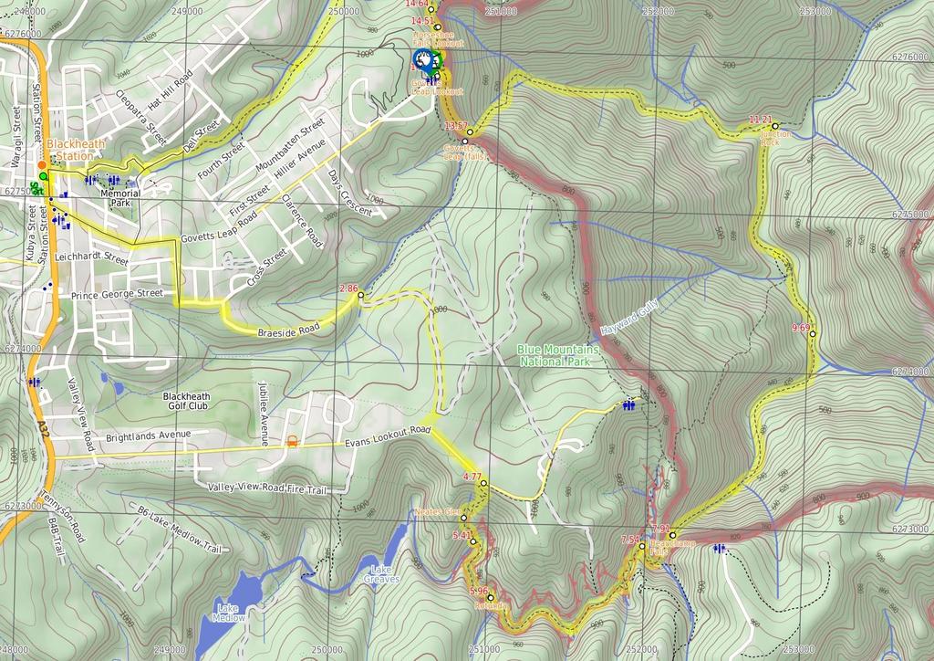
4 Continue straight: From the intersection, this walk follows the sign to 'Govetts Leap carpark' up the stairs. The walk zigzags up the hill before tending left to the signposted intersection. Turn left: From the intersection, this walk heads across the grassed area towards a platform structure. The walk climbs some stairs onto Govetts Leap Lookout, with its great views and sandstone monuments Govetts Leap Lookout Govetts Leap Lookout is named after the first European man to have enjoyed this view, William Govett, as an assistant surveyor in June Govetts Leap Lookout offers wonderful views over the Grose Valley and the spectacular Bridal Falls. The word `leap` is an old Scottish word meaning waterfall. The lookout is easily accessed from the car park, there are also toilets and picnic shelters nearby Govetts Leap Lookout (340 m 11 mins) Turn around: From Govetts Leap Lookout, this walk heads down the stairs at the edge of the lookout, keeping the valley to the right. The walk then crosses a grassed area to a well-signposted intersection on the edge of the tree line. Turn left: From the intersection, this walk heads down some stairs, keeping the valley to the right. The walk turns right over a bridge, continuing around the hillside to drop down onto a viewing area and intersection. Veer left: From the intersection, this walk heads down steep stairs, keeping the valley to the right. The track then winds along the cliff top until coming to an intersection, near Horseshoe Falls Lookout Horseshoe Falls Lookout Horseshoe Falls Lookout, Blue Mountains National Park, is a small fenced lookout. There are views down to Horseshoe Falls and across the Grose Valley Horseshoe Falls Lookout (140 m 4 mins) Continue straight: From the intersection, this walk heads along the cliff top towards Horseshoe Falls, with the valley below to the right. The track winds for some time around the hillside, to a lookout on the right, before continuing around to a railing some steep stairs. The stairs lead to Popes Glen Creek, where the track continues through the ferns to meet a street sign Int. Popes Glen Trk and Pulpit Rock Trk (310 m 7 mins) Continue straight: From the intersection, this walk follows the sign to 'Popes Glen' keeping the creek below on the right. The track continues for approximately 100m, rising to the left of a prominent rock feature. The walk passes another track on the right (with access to the creek), then continues to rise past the rock feature (on the right - The rock feature has a trail to its top.) This walk continues from the rock feature, heading down the hill to a signposted intersection Optional sidetrip to Boyd Beach (40 m 1 mins) Turn right: From the intersection, this walk heads down the hill following the 'Boyds Beach' sign (under the bush). The walk winds down the rocky steps for approximately 40m to Boyd Beach. At the end of this side trip, retrace your steps back to the main walk then Continue straight Boyd Beach Boyd Beach, Blue Mountains National Park, is a small sandy bank on Popes Glen Creek. The beach is a quiet spot with nice ferns and shade. The beach is a short distance from the Popes Glen track Int. Popes Glen Trk and Boyd Bch Trk (3.3 km 1 hr 15 mins) Turn left : From the intersection, this walk heads up the hill, following the arrow on the sign pointing to 'Blackheath'. The track continues above the creek (on the right) for some time, then crosses a bridge so that the creek is now on the left. The walk crosses a second bridge, then continues for some time up a rocky hill to an intersection below power lines, with a bridge below on the right. Continue straight: From the intersection, this walk heads up the hill, keeping the creek below on the right. The walk soon crosses the creek at a bridge, continuing along the other side to a small waterfall (on the left). The track then continues up the hill for for a short time, passing an intersection (with access tracks to Clarence Rd). The track continues to head up the hill for approximately 300m to the intersection with Dell St. Veer left: From the intersection, this walk heads down Dell St, keeping the bush to the left of the road and houses to the right. The walk soon passes Cleopatra St on the right and continues along Dell St to the intersection with Gipps Lane, on the right (where Dell St changes name to Wills St). Turn right: From the intersection, this walk heads along Gipps Lane, passing a large wooden house to the right of the road. The road tends left onto Robertson Lane which then becomes Wills St. The walk follows Wills Street for sometime to turn left onto Inconstant St and then right onto Gardiner Cres. Gardiner Cres is followed to the Great Western Highway, where there is a petrol station on the left. From here, this walk turns left to follow the Great Western Highway, keeping the petrol station on the left, as the walk heads towards the Gardners Inn pub. This walk continues to the pedestrian crossing, opposite Blackheath Station steps. Turn right: From the pedestrian crossing, this walk crosses the Great Western Highway to turn right up the covered station steps. The walk follows the railway bridge to the top of the station staircase.
5
6
7 Summary navigation sheet for the Blackheath Station to Junction Rock Loop (via Grand Canyon and Popes Glen) km Up/Dwn Length Initial directions (Use full tracknotes and maps for more detail) Start Blackheath Station , (GR Katoomba, ) 2.86 Int. Braeside Service Trail and Braeside Picnic Area , (GR Katoomba, ) km 52 mins 1.9 km 36 mins m 18 mins 540 m 14 mins 1.6 km 45 mins 380 m 16 mins 1.8 km 58 mins 1.5 km 30 mins 2.4 km 1 hr 15 mins 610 m 42 mins 340 m 11 mins 140 m 4 mins 310 m 7 mins 40 m 1 mins 3.3 km 1 hr 15 mins Powered by TCPDF ( From Neates Glen car park , (GR Katoomba, ) Neates Glen car park sign , (GR Katoomba, ) Rotunda , (GR Katoomba, ) Int. Grand Canyon and Rodriguez Pass Tracks , (GR Katoomba, ) Beauchamp Falls , (GR Katoomba, ) Govetts and Greaves Flats , (GR Katoomba, ) Junction Rock , (GR Katoomba, ) Bottom of Govetts Leap falls , (GR Katoomba, ) Govetts Leap Lookout , (GR Katoomba, ) Horseshoe Falls Lookout , (GR Katoomba, ) Int. Popes Glen Trk and Pulpit Rock Trk , (GR Mount Wilson, ) Int. Popes Glen Trk and Boyd Bch Trk , (GR Mount Wilson, ) Int. Popes Glen Trk and Boyd Bch Trk , (GR Mount Wilson, ) From the top of the station steps, this walk heads towards the Great Western Highway and Gardners Inn. Veer right: From the 'Braeside Walk' signposted intersection, this walk leaves the 'Braeside Walk' sign behind on the left as it continues along the service trail towards a waterfall. Veer right: From Neates Glen car park, this walk heads down the stairs following the 'Grand Canyon Track' signs. Continue straight: From the sign, this walk heads away from the creek and car park, following a short section of a rock shelf to round the corner of the hill. Turn right: From the intersection, this walk follows the sign to 'Evans Lookout', winding around the side of the canyon under the rock overhangs. Turn right: From the intersection, the walk follows the signs to 'Rodriguez Pass' around the canyon side, with the creek on the left. Continue straight: From Beauchamp Falls, this walk heads down the hill keeping the valley on the right. Continue straight: From the intersection to the camp area, this walk heads downstream along the creek flats, below on the right of the track. Turn left: From Junction Rock, the walk follows the 'Govetts Leap' sign, soon crossing the brook. Continue straight: From the bottom of Govetts Leap Falls, this walk heads north-west, following the blue signs up the hill. Turn around: From Govetts Leap Lookout, this walk heads down the stairs at the edge of the lookout, keeping the valley to the right. Continue straight: From the intersection, this walk heads along the cliff top towards Horseshoe Falls, with the valley below to the right. Continue straight: From the intersection, this walk follows the sign to 'Popes Glen' keeping the creek below on the right. Optional sidetrip to Boyd Beach. Turn right: From the intersection, this walk heads down the hill following the 'Boyds Beach' sign (under the bush). Turn left : From the intersection, this walk heads up the hill, following the arrow on the sign pointing to 'Blackheath'.
Govetts Leap Loop. 1065m. 909m Blue Mountains National Park. 4 hrs 30 mins 8.7 km Circuit. Hard track 380m
 Govetts Leap Loop 4 hrs 30 mins 8.7 km Circuit Hard track 380m This walk, from Blackheath Train Station, is a fantastic way to see some of the iconic areas of the Blue Mountains in the Blackheath area.
Popes Glen, Pulpit Rock, Govetts Leap and Braeside Walk
 Popes Glen, Pulpit Rock, Govetts Leap and Braeside Walk 8 hrs Hard track 13.6 km Circuit 4 1068m This large circuit walk, from Popes Glen to Pulpit Rock, Govetts leap and along the Braeside Track, passes
Carrington Park to Leura Forest and pass loop
 Carrington Park to Leura Forest and pass loop 3 hrs Hard track 4.8 km Circuit 4 674m This walk is a fantastic way to see Leura Forest. The walk descends from Carrington Park, visiting Leura Forest and
Wentworth Falls Conservation Hut Loop
 Wentworth Falls Conservation Hut Loop 3 hrs Hard track 6.7 km Circuit 4 341m This scenic walk from Wentworth Falls Station, winds along the Nature Trail to Conservation Hut, then drops into the magnificent
Echo Point to Leura Forest via Three Sisters and Giant Stairs loop
 Echo Point to Leura Forest via Three Sisters and Giant Stairs loop 3 hrs 3.8 km Circuit Hard track 512m This walk starts from the popular Echo Point, in Katoomba, and winds down to the base of the Three
Heathcote to Engadine via Audley
 Heathcote to Engadine via Audley 6 hrs 3 mins 5 km One way Hard track 4 635m Covering a large section of central Royal National Park, this walk goes through the heath and scrub along a well managed and
Katoomba Falls Circuit
 Katoomba Falls Circuit hr 5 mins.5 km Circuit Hard track 59m For those looking for a walk involving more than simple boardwalk, this trail winding through the temperate rain forest could be just the thing.
Wattamolla to Big Marley Beach
 Wattamolla to Big Marley Beach 4 hrs 10.4 km Circuit Moderate track 4m This walk is an excellent loop which takes in both the coast and the heathy inland of Royal National Park. Nearly the whole walk has
Waterfall to Heathcote
 Waterfall to Heathcote 5 hrs Hard track 10.8 km One way 4 467m This walk explores the heart of Heathcote National Park, and is easily accessed with a train station at either end. Although relatively close
Rail to River Walk. 3 hrs. Hard track 7.5 km Circuit. 222m
 Rail to River Walk 3 hrs Hard track 7.5 km Circuit 4 222m This walk is a great one from Chatswood Station to the Lane Cove River National Park. The walk descends through the vegetated bushland which fills
Hunters Hill to Epping Road
 Hunters Hill to Epping Road 2 hrs 30 mins 5.5 km One way Moderate track 154m An enjoyable walk through lower sections of the Lane Cove National Park, this walk features plenty of mangroves next to the
Little Digger Track. 68m. 1 Hr 2.2 km One way. Moderate track 93m. Moores Creek Reserve
 Little Digger Track Hr 2.2 km One way Moderate track 93m This walk follows Moores Creek through several reserves in east Roseville and East Lindfield. The track is named after Australia's 7th Prime Minster,
Currie Rd to Davidson Park
 Currie Rd to Davidson Park 3 hrs 7.2 km One way Moderate track 28m Starting at Currie Rd in Forestville, this walk follows Middle Harbour to Davidson Park, under Roseville Bridge. There are two optional
Mackerel Beach, West Head Loop
 Mackerel Beach, West Head Loop 5 hrs 8.6 km Circuit Hard track 422m The Mackerel Beach, West Head Loop is a walk which explores a large part of the West Head. The journey starts and finishes with a ferry
Little Digger Track to Davidson Reserve and Lyrebird Circuit
 Little Digger Track to Davidson Reserve and Lyrebird Circuit 4 hrs 3 mins 11.5 km One way Hard track 4 47m Exploring both the eastern and western sides of Middle Harbour Creek, this walk follows the Little
Mackerel Beach and Resolute Loop
 Mackerel Beach and Resolute Loop 3 hrs 5.4 km Circuit Hard track 384m This walk is another great walk in Ku-ring-gai Chase National Park, accessed by ferry. From the Mackerel Beach wharf, this walk uses
Morgans Creek to Padstow
 Morgans Creek to Padstow 2 hrs 45 mins 8 km One way Moderate track 3 144m This pleasant walk starts from the Morgans Creek park, at Henry Lawsons Drive, and follows the Georges River past the Boomerang
The Basin Track and Mackerel Track
 The Basin Track and Mackerel Track 3 hrs 5.9 km Circuit Hard track 226m This walk is a great way to see some popular areas in Ku-ring-gai Chase National Park. The walk from West Head Rd travels to The
Hornsby Blue Gum Walk
 Hornsby Blue Gum Walk 3 hrs Hard track 6.7 km Circuit 4 374m This delightful loop is one of the prettiest and most popular walks in the Hornsby area. Going from an environment of ferns and clear bushland
Campbell Drive to Snapper Point
 Campbell Drive to Snapper Point 1 hr 45 mins 4.2 km One way Experienced only 135m This walk follows the Coast Track to Frazer Beach, along the Geebung and (overgrown) Grass Tree Tracks. From the northern
Wallarah Coastal Walk
 Wallarah Coastal Walk 3 hrs 8.3 km Return Hard track 247m This walk starts at Caves Beach and travels south along the coastline, until reaching the Pinney s Headland Lookout. There are many opportunities
National Pass from Wentworth Falls to Conservation Hut
 National Pass from Wentworth Falls to Conservation Hut 3 hrs Hard track 3.6 km One way 739m Starting at Wentworth Falls picnic area, this scenic and historic walk explores many waterfalls, lookouts and
Callicoma Loop. 174m. 98m. 2 hrs. Hard track 5.1 km Circuit. 153m
 Callicoma Loop 2 hrs Hard track 5.1 km Circuit 153m This great circuit walk passes through some really nice forest around the fringe of Cherrybrook. Highlights of the walk include some beautiful rock overhangs
Sid Pulsford Walk. 175m. 33m. 1 hr 45 mins 4.1 km One way. Hard track 118m. Gosford LGA
 Sid Pulsford Walk 1 hr 5 mins.1 km One way Hard track 118m Sid Pulsford Walk explores the ridge top of Kincumber Mountain, from Honeman's Rock to Green Point. The walk mostly follows wide management trails.
Under and Over Cliff Walk
 Under and Over Cliff Walk 4 hrs 9.4 km Circuit Moderate track 576m This walk from Wentworth Falls Station is a fantastic way to see a large majority of the Wentworth Falls cliffline. The track winds under
Epping to Eastwood Station (via Lane Cove River)
") Epping to Eastwood Station (via Lane Cove River) hrs 45 mins 10.2 km One way Moderate track 189m Epping to Eastwood, via Lane Cove River, is the longer route through the bush between the stations. This
Epping to Eastwood Station (via Lane Cove River) hrs 45 mins 10.2 km One way Moderate track 189m Epping to Eastwood, via Lane Cove River, is the longer route through the bush between the stations. This
Wentworth Falls Station Loop (Undercliff Walk)
") Wentworth Falls Station Loop (Undercliff Walk) 4 hrs 3 mins Hard track 8.9 km Circuit 658m 4 This walk passes some stunning waterfalls and views into the Jamison Valley, following the cliff edges around
Wentworth Falls Station Loop (Undercliff Walk) 4 hrs 3 mins Hard track 8.9 km Circuit 658m 4 This walk passes some stunning waterfalls and views into the Jamison Valley, following the cliff edges around
Epping to Pennant Hills Station (via Lane Cove River)
") Epping to Pennant Hills Station (via Lane Cove River) 3 hrs 5 mins 8.4 km One way Hard track 249m This walk, from Epping to Pennant Hills Station, is a great way to see the upper Lane Cove River Valley.
Epping to Pennant Hills Station (via Lane Cove River) 3 hrs 5 mins 8.4 km One way Hard track 249m This walk, from Epping to Pennant Hills Station, is a great way to see the upper Lane Cove River Valley.
Balmoral Beach to The Spit
 Balmoral Beach to The Spit 2 hrs 30 mins.3 km One way Hard track 85m This walks follows the coast from Balmoral to the Spit and across Spit Bridge. There are some alternate tracks to consider at high-tides,
Rail to River and Stringybark Creek Reserve Walk
 Rail to River and Stringybark Creek Reserve Walk 4 hrs Hard track 11.2 km Circuit 4 302m This walk begins in the busy city of Chatswood and soon enters the nearby bushland around the Lane Cove River. The
The Foreshore Walk. 24m. 1m Lake Macquarie LGA. 1 hr 15 mins 2.9 km One way. Hard track 81m
 The Foreshore Walk 1 hr 15 mins 2.9 km One way Hard track 81m This walk traverses the coastline of the Green Point reserve. By following a variety of tracks and occasionally traveling inland through eucalyptus
Bouddi Coastal Walk. 5 hrs. Hard track 8.1 km One way. 364m
 Bouddi Coastal Walk 5 hrs Hard track 8.1 km One way 4 364m This is one of the longer walks in the Bouddi National Park and it is rich in scenery. The walk follows the coastline with many side trips to
Dead Horse Gap Loop track
 Dead Horse Gap Loop track 4 hrs 30 mins Hard track 9.8 km Circuit 144m 4 This walk starts with a ride up the Kosciuszko Express Chairlift. There is an opportunity to eat at Australia's highest restaurant,
Scenic World to Echo Point
 Scenic World to Echo Point 1 hr 15 mins 2.1 km One way Moderate track 192m This is one of the most popular tourist walks in the Katoomba area. The walk follows the cliffs along a well maintained and signposted
Federal Pass Walking Track
 Federal Pass Walking Track 5 hrs Hard track 8 km One way 4 989m This classic trail follows along the base of the cliffs from Leura to the Golden Stairs, passing many of the more popular sights of the Katoomba
De Burghs Bridge to Fullers Bridge
 De Burghs Bridge to Fullers Bridge 2 hrs 3 mins Hard track 6 km One way 2m 4 Following the Lane Cove River, this walk mostly follows a section of the Great North Walk and is well maintained and signposted.
Teralba to Charlestown Park track head
 Teralba to Charlestown Park track head 4 hrs 30 mins 13.3 km One way Moderate track 3 220m This section of the Great North Walk starts from the Teralba train station and winds down and around the edge
Wentworth Falls Station Loop
 Wentworth Falls Station Loop 5 hrs 3 mins 9.5 km Circuit Hard track 4 13m The Wentworth Falls Station Loop takes in most of the upper tracks around Wentworth Falls. There are many scenic views near the
Middle Harbour Creek Loop
 Middle Harbour Creek Loop 5 hrs 45 mins 15.1 km Circuit Experienced only 5 570m This walk explores the upper reaches of Middle Harbour Creek, starting and ending at the great parklands at Davidson Park,
Wentworth Falls Loop. 893m. 665m. 6 hrs 10.2 km Circuit. Hard track 1093m. Blue Mountains National Park
 Wentworth Falls Loop 6 hrs 1.2 km Circuit Hard track 193m This is a great walk, both in size and spectacular views. The walk makes its way from Wentworth Falls train station and drops off the plateau,
Upper Rumbalara circuit
 Upper Rumbalara circuit 1 hr 30 mins 3.3 km Circuit Hard track 176m A great circuit walk, covering most of the walking tracks and sights in the upper section of the Rumbalara Reserve. There is some really
Spit Bridge to Middle Head Forts
 Spit Bridge to Middle Head Forts 2 hrs 30 mins 6.3 km One way Hard track 4 181m This scenic walk takes you from the Spit Bridge, along the coast to explore the Middle Head Forts. There are a few alternate
Echo Point to Leura Forest Circuit
 Echo Point to Leura Forest Circuit 3 hrs 4.8 km Circuit Hard track 588m Forming a circuit around the cliffs and then the valley floor, this is a walk more then capable of convincing a walker of the beauty
De Burgs Bridge to Thornleigh station
 De Burgs Bridge to Thornleigh station 3 hrs 45 mins 9.7 km One way Hard track 4 363m This walk follows a section of the Great North Walk, starting from De Burghs bridge. The walk winds north west, through
Berowra to Mt Kuring-gai
 Berowra to Mt Kuring-gai 4 hrs 30 mins 9.4 km One way Hard track 4 551m From the ridges above Cowan Creek, this walk takes in some great lookouts (especially around Mt Kuringgai) as well as enjoying an
Sphinx, Warrimoo and Bobbin Head tracks
 Sphinx, Warrimoo and Bobbin Head tracks 4 hrs 9.6 km Circuit Moderate track 499m This great walk starts at the Sphinx Memorial and loops around via Cowan Creek, exploring diverse environments as it changes
Glenbrook and Euroka Circuit
 Glenbrook and Euroka Circuit 2 Days 16.6 km Circuit Experienced only 790m This two day circuit, returning to Glenbrook Station, is a scenic walk which passes many of the tourist attractions within the
Green Point Circuit Walk
 Green Point Circuit Walk 3 hrs 7.7 km Circuit Hard track 269m This walk visits all of the popular locations in Green Point Reserve, as well as some of the lesser-visited areas inland. Taking in Sea Eagle
Taronga Wharf to Chowder Bay
 Taronga Wharf to Chowder Bay 2 hrs 4.4 km One way Moderate track 246m Starting at Taronga Wharf, this walk passes many icons of Sydney, including Taronga Zoo, HMAS Sydney Mast, Chowder Bay. The walk also
Gordon to Chatswood Station
 Gordon to Chatswood Station 4 hrs 30 mins 12.2 km One way Hard track 4 381m This walk is a great way to get into the bush without being far from civilisation. The walk wanders through untouched valleys
Faulconbridge to Blaxland
 Faulconbridge to Blaxland 2 Days Experienced only 15.2 km One way 5 693m This two-day walk, or very solid one-day walk, takes you from station to station, through lush, scenic forest in the lower Blue
Patonga to Woy Woy. 5 hrs 45 mins 15.5 km One way. Hard track. 497m
 Patonga to Woy Woy 5 hrs 45 mins 15.5 km One way Hard track 4 497m This walk explores a variety of environments from the shore line and coastal cliffs near Patonga, to the dry, rocky and open ridge line.
Dubbo Gully and Ten Mile Hollow Circuit (via Clares Bridge)
") Dubbo Gully and Ten Mile Hollow Circuit (via Clares Bridge) 2 Days Hard track 24.3 km Circuit 4 1117m This two day (or ten hour) walk follows several historic roads, now closed to traffic. Starting with
Dubbo Gully and Ten Mile Hollow Circuit (via Clares Bridge) 2 Days Hard track 24.3 km Circuit 4 1117m This two day (or ten hour) walk follows several historic roads, now closed to traffic. Starting with
Woolwich Wharf to Boronia Park
 Woolwich Wharf to Boronia Park 2 hrs 5.8 km One way Moderate track 175m Going through the streets of Hunters Hill, this walk is on the first segment of the Great North Walk. The majority of the walk is
Epping to Gordon Station
 Epping to Gordon Station 4 hrs 15 mins 11.7 km One way Hard track 4 365m This walk, from Epping Station to Gordon Station, passes below the homes which sit on the hills high above the Lane Cove River.
Roseville to Macquarie Park
 Roseville to Macquarie Park 3 hrs 3 mins 8.8 km One way Hard track 4 29m This walk starts at Roseville station and explores the streets and alleyways of Roseville before joining the main spine of the Great
Lane Cove Tourist Park River Circuit
 Lane Cove Tourist Park River Circuit 5 hrs 12 km Circuit Hard track 383m This walk follows a large section of Lane Cove River. The walk follows the Riverside Walking track up the Lane Cove River to De
Scenic world to Three Sisters Loop via Furber Steps
 Scenic world to Three Sisters Loop via Furber Steps 5 hrs 5.8 km Circuit Hard track 722m This walk starts from the popular Scenic World, in Katoomba, and winds down the Furber steps into the Jamison Valley,
Thornleigh to Hornsby
 Thornleigh to Hornsby 4 hrs Hard track 10.2 km One way 4 526m Starting at Thornleigh station you walk through suburban streets for a short while before diving into the bush at the southern end of Berowra
Spit Bridge to Manly (Manly Scenic Walkway)
") Spit Bridge to Manly (Manly Scenic Walkway) 3 hrs 45 mins 9.1 km One way Moderate track 349m The Spit to Manly walk is a classic bushwalk on Sydney's Northern Beaches. The walk follows a well-maintained
Spit Bridge to Manly (Manly Scenic Walkway) 3 hrs 45 mins 9.1 km One way Moderate track 349m The Spit to Manly walk is a classic bushwalk on Sydney's Northern Beaches. The walk follows a well-maintained
Rumbalara Explorer. 158m. 5m Rumbalara Reserve. 2 hrs 45 mins 6.1 km Circuit. Hard track 326m
 Rumbalara Explorer 2 hrs 5 mins 6.1 km Circuit Hard track 326m Pretty well the grand tour of the Rumbalara Reserve, this walk takes in much of the great scenery the reserve has to offer. The walk covers
The Coast Track. 2 Days. Hard track 27.4 km One way. 1351m
 The Coast Track 2 Days Hard track 27.4 km One way 4 1351m Heading south, this walk covers the coastline of the Royal National Park and can truly only be described as amazing. With breathtaking coastal
Bouddi Ridge and Coastal Walk
 Bouddi Ridge and Coastal Walk 2 Days Hard track 27 km Circuit 4 126m This overnight walk takes in the majority of the magnificent Bouddi National Park. The walk starts from the pleasant Putty Beach camping
Hermitage Foreshore Track
 Hermitage Foreshore Track 1 Hr 2.2 km One way Moderate track 123m The Hermitage Foreshore Walk is a wonderful way to explore Sydney Harbour from the perspective of South Head. This walk starts from Nielsen
Sphinx to Mt Kuring-gai
 Sphinx to Mt Kuring-gai 4 hrs 45 mins 1.7 km One way Hard track 673m This walk starts at the Sphinx War Memorial and follows some well maintained and popular walking tracks down to Cowan Creek. Enjoy the
Gosford to Lisarow. 202m
 Gosford to Lisarow 4 hrs 3 mins Hard track 11.3 km One way 4 479m This walk is a great way to explore the ridge-top bushland between Gosford and Lisarow. Passing through Rumbalara and Katandra Reserves,
Charlestown Park trackhead to Newcastle station
 Charlestown Park trackhead to Newcastle station 5 hrs 30 mins 12.1 km One way Hard track 4 287m This section of the Great North Walk starts from the Charleston Park track head and winds through the streets
Bobbin Head Loop. 166m. 0m Ku-ring-gai Chase National Park. 5 hrs 12.9 km Circuit. Hard track 619m
 Bobbin Head Loop 5 hrs 12.9 km Circuit Hard track 619m This great circuit walk enjoys a variety of landscapes in Ku-ring-gai Chase National Park. The walk starts at the historic Sphinx war memorial and
North Ryde Fairyland circuit
 North Ryde Fairyland circuit 2 hrs 30 mins Hard track 6.9 km Circuit 193m 4 Starting at North Ryde train station this walk explores a stretch of the Lane Cove River, visiting the historic Fairlylands Pleasure
Chatswood to Epping Station
 Chatswood to Epping Station 6 hrs Hard track 16.3 km One way 4 533m This walk, from Chatswood to Epping, is a long but enjoyable walk along the Lane Cove valley. The walk mostly follows the Lane Cove River
Manly to Seaforth Oval
 Manly to Seaforth Oval 5 hrs 45 mins 13.7 km One way Moderate track 3 624m This walk follows the Manly to Spit Scenic Walkway, then continues past The Spit Bridge to Seaforth Oval. The walk provides magnificent
Light to Light Walk 2 days
 Light to Light Walk 2 days 2 Days Hard track 3.9 km One way 4 794m Over two days, this classic walk explores the coast from Boyd Tower to the Green Cape Lighthouse in the south. Hegartys Bay Camp is over
Cape Banks Circuit. 50m. 2m Botany Bay National Park. 3 hrs 7.3 km Circuit. Hard track 190m
 Cape Banks Circuit 3 hrs 7.3 km Circuit Hard track 19m This Cape Banks Circuit has a lot to offer and is thoroughly recommended. The walking travels over beaches, through coastal forest and across exposed
Taronga Zoo to Spit Bridge
 Taronga Zoo to Spit Bridge 5 hrs Hard track 1.4 km One way 4 41m This is a scenic and culturally rich walk with views over Sydney Harbour and many interesting heritage buildings along the way. The start
Six Foot Track. 1212m
 Six Foot Track 3 Days 44.8 km One way Hard track 4 2066m This classic walk takes you from Katoomba to Jenolan Caves via a historic horse route. The walk travels mainly along well-maintained service tracks
Narrabeen Lagoon Trail (from Middle Creek)
") Narrabeen Lagoon Trail (from Middle Creek) 2 hrs 30 mins 8.6 km Circuit Very easy 1 105m The Narrabeen Lagoon Trail is a wonderful and accessible walk on the Northern Beaches of Sydney. The trail is used
Narrabeen Lagoon Trail (from Middle Creek) 2 hrs 30 mins 8.6 km Circuit Very easy 1 105m The Narrabeen Lagoon Trail is a wonderful and accessible walk on the Northern Beaches of Sydney. The trail is used
PRE-APPROVED WALKS. RED HANDS CAVE CIRCUIT Grade: Easy Description: A circuit walk from either the causeway or the Red Hands Cave parking area. 8km.
 Bushwalking Club Inc. PO Box 126 NSW 2777 www.springwoodbushwalker.org.au PRE-APPROVED WALKS The purpose of this list of pre-approved walks is to enable leaders to put on walks at very short notice (up
ULTRA-TRAIL AUSTRALIA May 2018 COURSE DESCRIPTION AND COURSE NOTES
 ULTRA-TRAIL AUSTRALIA 100 19-20 May 2018 COURSE DESCRIPTION AND COURSE NOTES LEG 1 Scenic World (Start) to Narrow Neck (Checkpoint 1) Course Description: From the start, at the front entrance of Scenic
Sydney to Thornleigh via Lane Cove Tourist Park
 Sydney to Thornleigh via Lane Cove Tourist Park 2 Days 33 km One way Hard track 4 1114m This overnight walk starts from the Obelisk in Macquarie Park, Sydney, at the official start of the Great North Walk.
Beautiful Walks from the Blue Ball Inn
 Walk No. 7 COAST AND VALLEY WALK Countisbury, Glenthorne, County Gate, Brendon, Rockford and Wilsham 10 MILES APPROX. Walking time 5 hours approx. (not including breaks)> OS Sheet 64/74 Lynton and Lynmouth.
Hammer Vale and Linchmere Common
 point your feet on a new path Hammer Vale and Linchmere Common Distance: 9 km=5½ miles or 6 km=3¾ miles easy walking with one steep section Region: Hampshire, West Sussex Author: Botafuego Refreshments:
THE BECK STONE Backstone Beck on Ilkley Moor
 THE BECK STONE Backstone Beck on Ilkley Moor 1 Three different routes which take in the best of the lower slopes of Ilkley Moor, with bracken, heather, a tarn (a small mountain lake) and rushing streams.
VERN S CAMP from Minginui
 VERN S CAMP from Minginui Map: Kuratau, 1:50,000 V18 Refer Figures 1, 3, 4 and 5 GPS: Geodetic Datum 1949 Refer Figure 10a (Geographic) and 10b (NZ Grid) How to get to START: From the police station on
10 Miles Circular 5 hours
 VISIT RYEDALE PICKERING AND CAWTHORN CAMPS 10 Miles Circular 5 hours Moderate Terrain 120616 A 10 mile (16km) there and back walk from the market town of Pickering in Ryedale. The route heads north through
Harbour Bridge to Taronga Zoo
 Harbour Bridge to Taronga Zoo 4 hrs 9.8 km One way Moderate track 389m On this walk, you will explore much of the foreshore linking Milsons Point Station to Taronga Zoo Ferry wharf. The walk is mostly
Detailed maps, and portaging and camping information follow.
 Overview of Bain route. The launch site is at Davidson Lake, just before the Manitoba/Ontario border. You can do a loop if you leave a vehicle at Tulabi Lake (at the canoe route parking lot). The road
BALCOMBE AND ARDINGLY RESERVOIR, WEST SUSSEX
 BALCOMBE AND ARDINGLY RESERVOIR, WEST SUSSEX 7 miles Circular 4 hours 080816 Challenging Terrain Hi, I'm Luke and this is my West Sussex Weekends walk It's a 7 mile loop from Balcombe rail station, taking
THE WELLDIGGERS ARMS, HESWORTH AND FITTLEWORTH TRAIL
 THE WELLDIGGERS ARMS, HESWORTH AND FITTLEWORTH TRAIL 5.5 miles Circular 3 hours 041017 Challenging Terrain A 300-year-old pub turned country-inn on the edge of the South Downs National Park, The Welldiggers
8 Miles Circular 4 hours
 VISIT RYEDALE HELMSLEY AND RICCAL DALE 8 Miles Circular 4 hours 090616 Challenging Terrain An 8 mile (13km) circular walk from the market town of Helmsley in Ryedale. The route heads out across sheep pastures
Start / Finish. Version 2
 Start / Finish Version 2 Gosford (Start) to Woy Woy Head South down Etna Street, crossing Henry Parry Drive, then Mann St, Gosford, where Etna St becomes Racecourse Road. Follow this road all the way
SELF GUIDED TOURING ROUTE
 SELF GUIDED TOURING ROUTE Things to see and places to go on the loop from Orbost to Marlo, Cape Conran, Cabbage Tree and back to Orbost (or onwards to Cann River) V6 April 2017 This guide should be read
Cross Country Skiing in the Tumbler Ridge Area
 Cross Country Skiing in the Tumbler Ridge Area There are numerous locations that are great for cross country skiing in the area surrounding Tumbler Ridge. Some are on trails that have hiking brochures
Calaveras Big Trees State Park--South Grove Loop
 Copyright 1999 by Jeff Robinson. You are free to use and reproduce this description for personal, not-for-profit, and not-forbusiness use. Any reproduction other than for personal use, including businesses,
Walk 7: Watchet to washford
 Walk 7: Watchet to washford Length: Moderate - 7.5 miles / 12 km Good For: Theme: History Duration: 2-3 hours depending on speed of walking Notes: This is a moderate to difficult walk in places, with steps,
Loch Ness Shores Club Site
 Loch Ness Shores Club Site Camping and Caravanning Falls of Foyers Route Summary A strenuous walk from Loch Ness Shores Club Site. The route climbs through forest to The Upper Foyers Waterfall and then
Times. S E S/Rd(E) Wakefield Road) Wakefield Rural Fire Brigade
 Wakefield Road) Wakefield Rural Fire Brigade") START On York Street, Teralba adjacent to Tulkaba Park Sports Pavilion (on leaving travel west on York Street) [EEP-1A] Position* Altitude Distance (km)* Trail S32 57.593 E151 36.520 21 0.5 0.5 S/Rd(E)
START On York Street, Teralba adjacent to Tulkaba Park Sports Pavilion (on leaving travel west on York Street) [EEP-1A] Position* Altitude Distance (km)* Trail S32 57.593 E151 36.520 21 0.5 0.5 S/Rd(E)
Launch A: Experimental Lakes Road The launch site is about 4 km from highway #17. There is a sign on the highway indicating the experimental lakes
 Launch A: Experimental Lakes Road The launch site is about 4 km from highway #17. There is a sign on the highway indicating the experimental lakes road. You have to cross railway tracks on the way to the
Macutagon Creek to Russell s Landing
 Day Trips Macutagon Creek to Russell s Landing Manitouwadge Public Consultation Committee Canoe Route #13 #13 MACUTAGON CREEK TO RUSSELL S LANDING This route is suitable to all levels of paddlers but due
VELINDRE VALLEYS WALK FOR STEFFAN
 VELINDRE VALLEYS WALK FOR STEFFAN IMPORTANT INFORMATION FOR WALKERS AND MARSHALS 1 Table of Contents Key Contact Numbers:... 3 Timetable and locations... 4 T-shirts... 4 Important Advice for Walkers...
NEWLANDS CORNER AND ST MARTHAS
 NEWLANDS CORNER AND ST MARTHAS 10k CIRCULAR ROUTE 2½-3HRS GU4 8SE From Newlands Corner on the North Downs just outside Guildford, you can enjoy one of the most beautiful panoramas of quintessential English