Final Report. Evaluation of Flashing Yellow Right Turn Arrow at Silverbell Rd and Cortaro Rd. FHWA Experimentation #4-329(E)
|
|
|
- Peter Russell
- 6 years ago
- Views:
Transcription


1 Final Report Evaluation of Flashing Yellow Right Turn Arrow at Silverbell Rd and Cortaro Rd FHWA Experimentation #4-329(E) Marana, Arizona January 2009 Submitted To: Submitted By:
2 FINAL REPORT EVALUATION OF FLASHING YELLOW RIGHT-TURN ARROW AT SILVERBELL RD AND CORTARO RD MARANA, ARIZONA FHWA Experimentation #4-329(E) Flashing Yellow Arrow for Right Turns Marana, AZ Prepared by Prepared for 800 East Wetmore Road Tucson, AZ Ph. (520) Town of Marana West Civic Center Drive Marana, AZ Psomas Project No January 2009
3 TABLE OF CONTENTS 1. EXECUTIVE SUMMARY 1 2. INTRODUCTION 3 3. TRAFFIC VOLUMES BEFORE CLOSURE AFTER CLOSURE JUNE AFTER CLOSURE OCTOBER ANALYSIS 8 4. CRASH EXPERIENCE VIDEO ANALYSIS DRIVER SURVEY RESULTS FINDINGS APPENDIX A: TRAFFIC VOLUME DATA APPENDIX B: CRASH DATA APPENDIX C: DRIVER SURVEY 56 January 2009 Flashing Yellow Arrow at Silverbell Rd and Cortaro Rd Final Report Page i
4 LIST OF TABLES Table 1. AM Peak Hour Volumes Cortaro Road at Silverbell Road 8 Table 2. PM Peak Hour Volumes Cortaro Road at Silverbell Road 8 Table 3. Changes in Volumes Wade Road North of Ina Road and Cortaro Road West of Silverbell Road 10 Table 4. Survey Responses 19 LIST OF FIGURES Figure 1. Project Area 3 Figure 2. Cortaro Road Westbound Right-Turn Movement at Silverbell Road 4 Figure 3. Traffic Volumes Before Closure of Silverbell Road (April 2008) 5 Figure 4. Traffic Volumes After Closure of Silverbell Road (June 2008) 6 Figure 5. Traffic Volumes After Closure of Silverbell Road (October 2008) 7 Figure 6. Crash Types Evaluated for Flashing Yellow Right-Turn Arrow 12 Figure 7. WB Cortaro Road East of Silverbell Road Turn Lane Transition 13 Figure 8. Red Light Running Incidents (per 1,000 RT Vehicles) 15 Figure 9. Signage for Flashing Yellow Right-Turn Arrow 16 Figure 10. Failure to Yield to Cross-Street Traffic Incidents (per 1,000 RT Vehicles) 16 Figure 11. Unnecessary Stops at the Flashing Yellow Arrow Incidents (per 1,000 RT Vehicles) 17 Figure 12. Frequency of Travel Survey Question Results 18 Figure 13. Time of Day Survey Question Results 20 Figure 14. Flashing Yellow Arrow Survey Question Results 21 Figure 15. Solid Red Arrow Survey Question Results 22 Figure 16. Intersection Operation Survey Question Results 23 Figure 17. Intersection Safety Survey Question Results 23 January 2009 Flashing Yellow Arrow at Silverbell Rd and Cortaro Rd Final Report Page ii
5 1. EXECUTIVE SUMMARY The Town of Marana completed the widening of Silverbell Road from Ina Road to Cortaro Road on November 1, 2008 Du r ing const ruct ion of t he pr oj ect (May 1, 2008 to Nov 1, 2008), a flashing yellow arrow was installed with the approval of the Federal Highway Administration to serve the westbound right-turn movement at the intersection of Silverbell Road and Cortaro Road. Traffic volume data, video data, crash data, and survey responses were collected by the Town to evaluate the operational and safety effectiveness of the flashing yellow arrow. Traffic volumes at the intersection were expected to decrease once construction began, but the volumes collected in June 2008 (one month after the closure) were lower than expected. The discrepancy may have been due to a number of factors, including the high gas prices at the time and the fact that summer volumes are typically lower than spring volumes. Therefore, traffic volumes were again collected in October 2008 for comparison. The October volumes were significantly greater than those collected in June and more closely resembled the volumes that were originally projected. In order to understand the changes drivers were making during construction, individual movements at the intersection of Silverbell Road and Cortaro Road were analyzed. Video was collected during the AM and PM peak periods by the Town one week, one month, three months, and six months after the closure on Silverbell Road. Three incident types were recorded by the town as a measure of driver understanding of the flashing yellow arrow at the intersection of Silverbell Road and Cortaro Road, including: Red Light Running Failure to Yield to Cross-Street Traffic Stopping at the Flashing Yellow Arrow It was found that red light running and stopping at the flashing yellow arrow decreased as time passed, an indication that drivers became more familiar with the new signalization and better understood its operation. In addition, after the Town of Marana installed signs to clarify the prohibition of right-turns-on-red in June, red light running decreased even further. The incident rate of vehicles that failed to yield to cross-street traffic was very low throughout the closure, but this type of incident contributed to the one intersection-related crash that occurred during the closure of Silverbell Road. The June 2008 crash was a sideswipe, involving January 2009 Flashing Yellow Arrow at Silverbell Rd and Cortaro Rd Final Report Page 1
6 a westbound right-turning vehicle that failed to yield to a northbound through vehicle. There were no reported rear-end or pedestrian crashes during the closure. The Town of Marana conducted a survey in the first month of the closure to determine how well drivers understood the operation of the intersection. The survey achieved an almost 50% response rate (439 completed questionnaires), and also collected information regarding drivers perception about the operation and safety of the intersection. Based on the survey results, 70% of respondents were satisfied or very satisfied with the operation of the intersection while the flashing yellow right-turn arrow was in place. A vast majority (92%) responded that they understood the need to proceed with caution at a flashing yellow arrow while yielding to opposing street traffic. A lesser majority (77%) responded that they understood a driver should remain stopped at a solid red arrow until the arrow changes. In both cases, drivers that traveled through the intersection at least five times per week selected the correct answer more often than those who traveled through the intersection four times or fewer per week. January 2009 Flashing Yellow Arrow at Silverbell Rd and Cortaro Rd Final Report Page 2
 as an Urban Principal Arterial, and it connects the Town of Marana, the City of Tucson, and unincorporated areas")
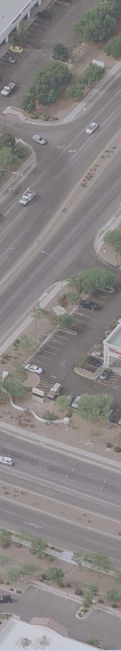
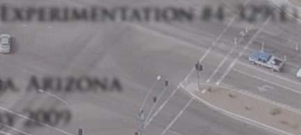
7 2. INTRODUCTION The Town of Marana recently completed the widening of Silverbell Road, a major regional roadway, to five lanes between Ina Road and Cortaro Road (Figure 1). Silverbell Road is currently classified by the Federal Highway Administration (FHWA) as an Urban Principal Arterial, and it connects the Town of Marana, the City of Tucson, and unincorporated areas of Pima County. The Town of Marana decided it would be best to close the roadway from just north of Ina Road to Bradstreet Drive (south of Cortaro Road) to accelerate construction, reduce project costs, facilitate traffic control, and improve worker safety. Figure 1. Project Area January 2009 Flashing Yellow Arrow at Silverbell Rd and Cortaro Rd Final Report Page 3

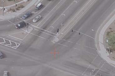
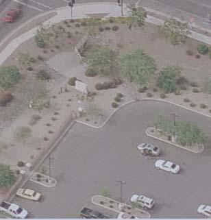
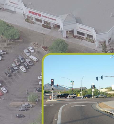
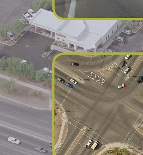
8 A traffic mitigation study was performed in June 2006 to evaluate the effects of the possible closure. As a result of that study, a request was made to the FHWA that the Town be permitted to use a flashing yellow arrow at the intersection of Silverbell Road and Cortaro Road to serve the westbound right-turn movement. The request was approved in April 2007, and the flashing arrow treatment was implemented (Figure 2) between May 1, 2008 (start of construction) and November 1, 2008 (end of construction). Figure 2. Cortaro Road Westbound Right-Turn Movement at Silverbell Road As part of the experimentation, initial and final reports were to be completed in order to evaluate the flashing yellow arrow for westbound right turns on Cortaro Road at Silverbell Road. The initial report, submitted in September 2008, analyzed the traffic volume changes associated with the closure (based on June 2008 volumes), summarized the initial crash experience, discussed the operational and safety trends observed from video data collected during peak periods, and presented the initial results of a driver survey conducted by the Town. This final report will include analysis of the October 2008 traffic volumes, crash data, video data, and driver surveys. January 2009 Flashing Yellow Arrow at Silverbell Rd and Cortaro Rd Final Report Page 4

9 3. TRAFFIC VOLUMES 3.1. BEFORE CLOSURE Traffic counts were collected on Tuesday, April 22, 2008 at the intersection of Silverbell Road and Cortaro Road, shortly before the Silverbell Road closure. Figure 3 shows those volumes. The morning and evening peak hours occurred from 6:45 AM to 7:45 AM and from 4:45 PM to 5:45 PM, respectively. Figure 3. Traffic Volumes Before Closure of Silverbell Road (April 2008) As seen in the figure, the highest volumes prior to the closure were the morning southbound left turns from Silverbell Road (1,397 veh/hr) and the evening westbound right turns from Cortaro Road (1,540 veh/hr). The high volumes are associated with commuters leaving the largely residential area to the northwest of the intersection and traveling along Cortaro Road to reach Interstate 10. Southbound and northbound through volumes exhibit a similar pattern (high southbound volume in the morning, high northbound volume in the evening), an indication of drivers traveling along Silverbell Road to Ina Road in order to access I-10. January 2009 Flashing Yellow Arrow at Silverbell Rd and Cortaro Rd Final Report Page 5

10 3.2. AFTER CLOSURE JUNE 2008 Traffic volumes were again collected on Wednesday, June 4, 2008, approximately one month after Silverbell Road was closed for construction and the flashing yellow arrow was activated for westbound right turns at the Silverbell Road/Cortaro Road intersection. The counts were taken one month after the closure in order to allow drivers time to adjust to the closure and determine which route they would be using. Figure 4 shows the volumes. The morning and evening peak hours occurred from 7:00 AM to 8:00 AM and from 5:00 PM to 6:00 PM, respectively. Figure 4. Traffic Volumes After Closure of Silverbell Road (June 2008) As was expected, the morning southbound left turns and evening westbound right turns are still the highest volumes at the intersection. However, with the closure of Silverbell Road south of Cortaro Road, the northbound and southbound through volumes were reduced significantly. The westbound left-turn volumes also decreased. January 2009 Flashing Yellow Arrow at Silverbell Rd and Cortaro Rd Final Report Page 6

11 3.3. AFTER CLOSURE OCTOBER 2008 Overall, the traffic volumes collected in June 2008 were lower than originally estimated. The lower volumes could have been attributable to several conditions ranging from lower school traffic and a lower retiree population in the summer months, to high gas prices (further discussion is provided in Section 3.4). In order to gain a better understanding of the volumes, and to identify if the aforementioned factors had any impact on traffic, peak hour volumes were collected again on Wednesday, October 22, 2008, shortly before the completion of the Silverbell Road construction. Figure 5 shows the volumes. The morning and evening peak hours took place from 6:45 AM to 7:45 AM and from 5:15 PM to 6:15 PM, respectively. Figure 5. Traffic Volumes After Closure of Silverbell Road (October 2008) Again, the morning southbound left turns and evening westbound right turns were the highest volumes at the intersection. Overall, the volumes increased significantly from June 2008 in both the AM and PM peak hours, with a majority of the increased volume on Silverbell Road. January 2009 Flashing Yellow Arrow at Silverbell Rd and Cortaro Rd Final Report Page 7
12 3.4. ANALYSIS As part of the 2006 traffic mitigation study, traffic volumes were collected in May In addition, projections were also made in the report about the redistribution of traffic once Silverbell Road was closed and the flashing yellow arrow for westbound right turns was activated at the intersection of Silverbell Road and Cortaro Road. Those two volumes, as well as the volumes collected in April 2008 just before the road closure, in June 2008 approximately one month after the road closure, and in October 2008 just before the road reopening, are presented by movement in Tables 1 and 2. Table 1 shows the volumes for the morning peak hour, and Table 2 shows the volumes for the evening peak hour. No Closure May :00-8:00 AM No Closure April :45-7:45 AM With Closure Projected Volumes* Table 1. AM Peak Hour Volumes Cortaro Road at Silverbell Road 7:00-8:00 AM With Closure June :00-8:00 AM With Closure Date October 2008 Peak Hour 6:45-7:45 AM NB Silverbell Road Left Right Thru Turn Turn U Turn U Turn SB Silverbell Road Left Right Thru Turn Turn U Turn EB Cortaro Road Left Right Thru Turn Turn U Turn WB Cortaro Road Left Right Thru Turn Turn , , , , , , , , , ,608 *Estimated volume after closure, based on May 2006 volumes. Total Intersection Volume No Closure May :00-6:00 PM No Closure April :45-5:45 PM With Closure Projected Volumes* Table 2. PM Peak Hour Volumes Cortaro Road at Silverbell Road 5:00-6:00 PM With Closure June :00-6:00 PM With Closure Date October 2008 Peak Hour 5:15-6:15 PM NB Silverbell Road Left Right Thru Turn Turn U Turn SB Silverbell Road Left Right Thru Turn Turn U Turn U Turn EB Cortaro Road WB Cortaro Road Total Left Right U Left Right Thru Thru Turn Turn Turn Turn Turn ,684 3, ,540 3, ,996 3, ,471 3, ,478 3,353 *Estimated volume after closure, based on May 2006 volumes. Intersection Volume As discussed in the Initial Report (September 2008), the volumes collected in June 2008 were significantly lower than what was projected The di ff erence was thought to be attributed to a number of factors, including: January 2009 Flashing Yellow Arrow at Silverbell Rd and Cortaro Rd Final Report Page 8
13 Summer traffic volumes are typically lower than spring traffic volumes because school is out of session for the summer and the winter residents of the Tucson area leave before the summer months; and The considerable increase in the price of gasoline during the preceding months may have caused drivers to travel less and to consolidate trips. In order to determine if those factors actually influenced the traffic volumes collected in June, peak hour volumes were collected again in October 2008, shortly before Silverbell Road was reopened. The purpose was to capture the effects of some of the winter traffic, the school traffic, and the lower price of gasoline. As seen in Tables 1 and 2, the volumes collected in October 2008 are significantly higher than those collected in June 2008, and also correspond much better to the volumes originally projected during both peak hours. From Table 1, the total volume at the intersection in the AM peak hour was projected to decrease from 2,730 vehicles (in May 2006) to 2,617 vehicles (after closure). The decrease in overall volume was anticipated because some drivers were expected to use Wade Road as an alternate route to access Ina Road, bypassing the Silverbell Road/Cortaro Road intersection. By April 2008, the total AM peak hour volume had increased to 2,769 vehicles. In October 2008, the AM peak hour volume was 2,608 vehicles, nearly matching what was originally projected. Similarly, PM peak hour volumes were projected to decrease from 3,901 vehicles in May 2006 to 3,714 vehicles after the closure (Table 2) In Apr i l 2008, 3,454 vehicles were counted at the intersection, decreasing to 3,353 in October While the volume was significantly lower than what was projected, the decrease in volumes from April 2008 to October 2008 (2.9%) resembled the projected decrease of 4.8%. Traffic volumes were also collected on Cortaro Road west of Silverbell Road and on Wade Road north of Ina Road in order to assess the number of vehicles using those alternate routes. A summary of those volumes is included in Table 3. As indicated, on Cortaro Road west of Silverbell Road (north of Ina Road), the largest change in volumes was experienced in the evening peak period, with approximately 200 vehicles per hour using eastbound Cortaro Road to Silverbell Road as a result of the construction project. Overall, Cortaro Road west of Silverbell Road served as an efficient detour in the evening peak period, but fewer drivers than expected used it during the morning peak period. January 2009 Flashing Yellow Arrow at Silverbell Rd and Cortaro Rd Final Report Page 9
14 Table 3. Changes in Volumes Wade Road North of Ina Road and Cortaro Road West of Silverbell Road Oct Existing Projected with Closure CORTARO WEST OF SILVERBELL ADT 7-8 AM 5-6 PM WB 2, EB 2, Total 5, WB EB Total WB EB Total Actual Change in Vols Projected Change in Vols Oct Existing Projected with Closure WADE NORTH OF INA Day 7-8 AM 5-6 PM SB 1, NB 1, Total 2, SB NB Total SB NB Total Actual Change in Vols Projected Change in Vols Difference 7% 7% The volumes measured on Wade Road in October 2008 showed an increase of 164 veh/hr in the PM peak hour and 103 veh/hr in the AM peak hour (both relative to 2006 levels). Both are indications that the roadway was extensively used by drivers as an alternate route during the closure. In fact, the actual volume increases slightly exceeded the forecasted change in volumes. In order to understand the changes drivers were making at the intersection of Silverbell Road and Cortaro Road, individual movements were analyzed. Northbound traffic greatly decreased between April 2008 and October However, the October 2008 volumes were significantly higher than projected. The traffic on that leg is most likely from the largely residential area served by Silverbell Road south of Cortaro Road, but a contributing factor may have been drivers exiting the Walgreens east of Silverbell Road. Another potential source of trips is a new public library that opened in the summer along that segment of Silverbell Road. January 2009 Flashing Yellow Arrow at Silverbell Rd and Cortaro Rd Final Report Page 10
15 It was projected that much of the original southbound through volume would be redistributed to become southbound right and left turns at the intersection. While the October 2008 counts showed a significant decrease in the southbound through volume in both peak hours, the volume increase for right turns did not meet projections. However, the volume increase for southbound left turns matched the projections closely. The October 2008 volumes were significantly higher than those collected in June 2008, reinforcing the original idea that the traffic volumes collected in June were not only affected by the construction, but by other background factors (time of year, gas prices) as well. The projections also showed that eastbound left-turn and through volumes would increase in both the morning and evening peak hours after the road closure. As seen in the tables, the increase in the eastbound through volumes was greater than expected. Conversely, although the eastbound left-turn volume did increase, it did not meet projections. The eastbound left-turn volume increase was attributed to vehicles using Ina Road to access Cortaro Road, then traveling northwest to the Cortaro Road/Silverbell Road intersection. The largest discrepancy between the projected volumes and the observed volumes was in the westbound right turns during the evening peak hour. In October 2008, the right turns in the morning peak hour had increased approximately 6%, less than the projected 13%. The observed right-turn volume is significantly less than what was projected because the volume decreased significantly before the project began. In the evening peak hour, it was expected that the right-turn volume would increase 18% from 1,694 vehicles to 1,996 vehicles. Instead, the volume decreased 4% from 1,540 vehicles just before the closure to 1,478 vehicles after the closure (October 2008). Further, the total incoming volume, those vehicles making movements to travel north on Silverbell Road (eastbound left turns, northbound throughs, and westbound right turns), was expected to decrease by less than 1% in the evening peak hour (8 vehicles). The counts collected show that the decrease was actually 15% (301 vehicles), a large part of which was attributed to the observed change in the westbound right-turn volumes. This difference is difficult to explain, because the northbound traffic on Wade Road (the only alternate route that completely avoids the intersection) did not increase beyond the projected volumes. Therefore, it is possible that travel in the area decreased slightly in relation to January 2009 Flashing Yellow Arrow at Silverbell Rd and Cortaro Rd Final Report Page 11
16 4. CRASH EXPERIENCE Crash records were used to help identify the safety impacts of the flashing yellow arrow for westbound right turns As shown i n Fi gur e 6, t he t ypes of crashes that were of the highest interest in this situation were pedestrian collisions with right-turning vehicles, rear-end crashes between westbound right-turning vehicles, and sideswipes (or right-turn angle crashes) between right-turning vehicles and through traffic on the north leg of Silverbell Road. P N Silverbell Rd P Cortaro Rd Figure 6. Crash Types Evaluated for Flashing Yellow Right-Turn Arrow Crash data was received from the Town of Marana for the Silverbell Road/Cortaro Road intersection covering the period from May 1, 2008 through November 1, During that period, which is when Silverbell Road was under construction, there were four crashes at the intersection. Three of the crashes were not related to the implementation of the flashing yellow right-turn arrow. The three collisions involved vehicles trying to merge into one of the westbound rightturn lanes at the last minute, which was a frequent occurrence even before Silverbell Road was closed. As seen in Figure 7, the distance provided for westbound vehicles to move from the through lanes into the right-turn lanes is very short. As a consequence, vehicles often try to move into the right-turn lane further west (closer to the Silverbell Road/Cortaro Road intersection), which on occasion leads to sideswipe crashes with vehicles already in the turn lanes. January 2009 Flashing Yellow Arrow at Silverbell Rd and Cortaro Rd Final Report Page 12

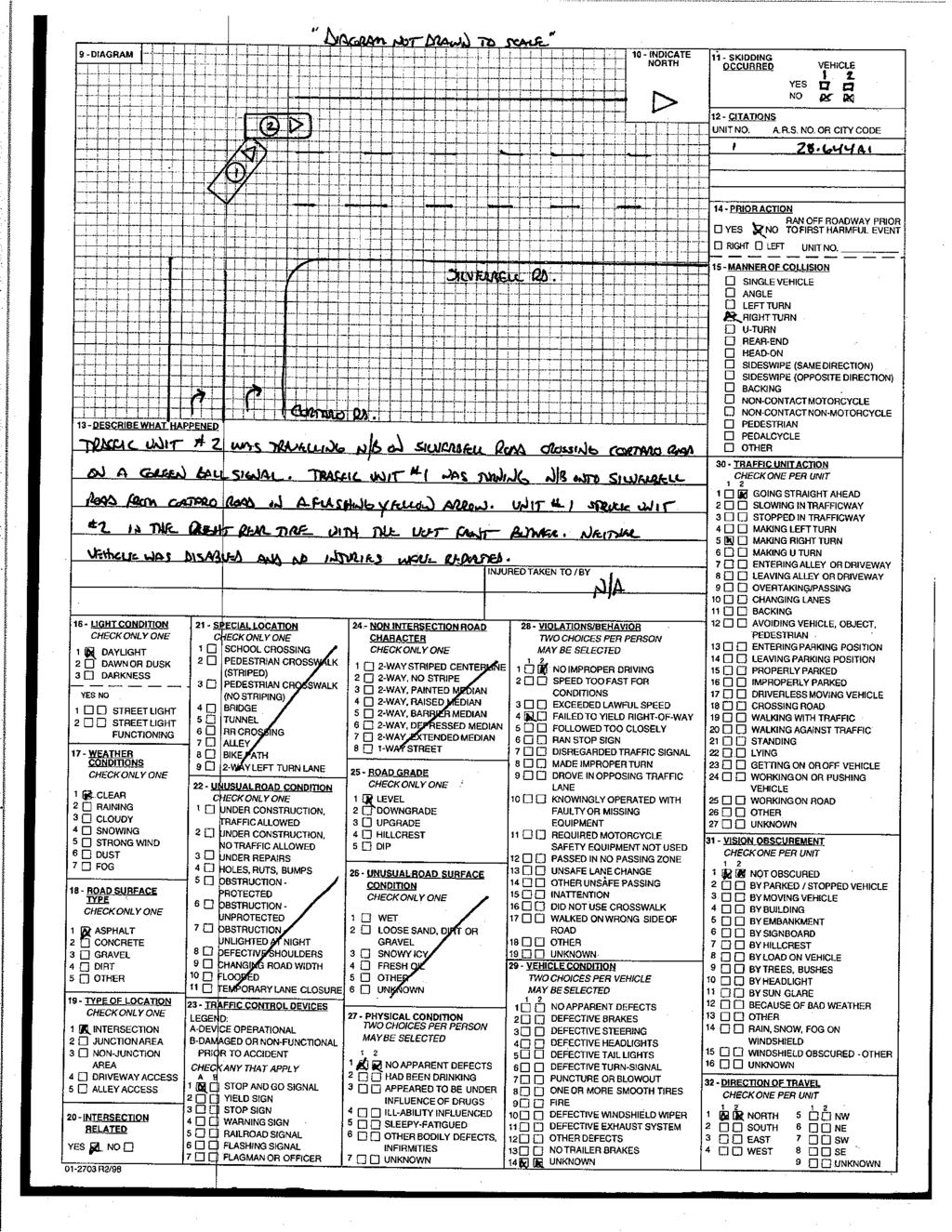
17 Weaving Area Cortaro Road Figure 7. WB Cortaro Road East of Silverbell Road Turn Lane Transition Only one of the four crashes was associated with the implementation of the flashing yellow right-turn arrow. The crash involved a westbound right-turning vehicle that failed to yield the right-of-way and sideswiped another vehicle that was traveling northbound on Silverbell Road through the intersection. Neither vehicle was disabled and no injuries were reported. The crash took place at noon on June 18, more than 45 days after the installation of the flashing yellow arrow. No other contributing factors were identified, as the weather was clear and the signal was working properly. The crash report for this incident is included in Appendix B. January 2009 Flashing Yellow Arrow at Silverbell Rd and Cortaro Rd Final Report Page 13
18 5. VIDEO ANALYSIS Video data was collected during the morning and evening peak periods approximately one week, one month, three months, and six months after the closure of Silverbell Road south of Cortaro Road. The data was analyzed by the Town of Marana to evaluate compliance with the flashing yellow right-turn arrow and potential safety conflicts. Three types of situations were identified as potential compliance problems or as an indication of a lack of understanding of the flashing arrow. Those incident types were: Red Light Running Failure to Yield to Cross-Street Traffic Stopping at the Flashing Yellow Arrow Red light running is when a vehicle makes a right turn during the red arrow indication, which is illegal. This can be either a vehicle that approaches the intersection as the arrow is turning to red and makes the turn anyway or a vehicle that comes to a stop at the red arrow then decides to make the right-turn movement during an acceptable gap in traffic. This is a compliance issue, as the red right-turn arrow has been in use at this intersection and several others in the Tucson area for many years. Violation of the red arrow could result in right-turn crashes with northbound traffic. A driver may also fail to yield to cross-street traffic when making the westbound right turn at the intersection. This occurs during the flashing yellow arrow indication when a westbound vehicle makes a right turn into a northbound lane on Silverbell Road that is occupied by at least one northbound through vehicle, requiring one or both vehicles to take evasive action. Potential evasive actions include braking or abrupt steering. Failure to yield is associated with either driver inattention or lack of understanding the flashing yellow arrow, and could lead to conflicts between westbound right-turn and northbound through vehicles. The third type of incident is stopping at the flashing yellow arrow, which involves a vehicle coming to a complete stop for three seconds or more before proceeding through the flashing yellow arrow, even when there are no conflicting cross-street vehicles. This may result in rearend near-misses or collisions since drivers do not expect other vehicles to stop during the flashing yellow arrow indication. January 2009 Flashing Yellow Arrow at Silverbell Rd and Cortaro Rd Final Report Page 14
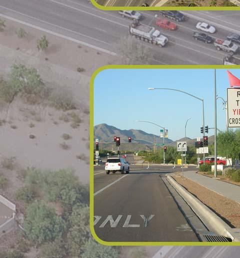
19 The results of the analysis performed by the Town of Marana are summarized in Figures 8, 10, and 11. The figures show the results as incidents per 1,000 right-turning vehicles in order to get a measure of exposure. The right-turning vehicles include only westbound traffic Number of Incidents per 1,000 RT Vehicles Added No Turn on Red Signs AM PM Week After Closure 1 Month After Closure 3 Months After Closure 6 Months After Closure Figure 8. Red Light Running Incidents (per 1,000 RT Vehicles) The number of drivers running the red light (turning right on a red arrow) was higher than anticipated one week and one month after the closure. After observing these trends (as discussed in the Initial Report), the Town of Marana re-installed No Turn on Red (R10-11a) signs for the westbound right-turn movement on June 20, 2008 (Figure 9). The signs had been removed with the installation of the flashing yellow right-turn arrow to avoid sign clutter at and approaching the intersection. The data collected three months after closure shows a slight increase in the number of incidents per 1,000 right-turning vehicles during the AM peak hour, but a significant decrease in the PM peak hour (8.5 incidents per 1,000 RT veh to 3.8 incidents per 1,000 RT veh). Six months after the closure (and four months after the signs had been reinstalled), the number of incidents had decreased even further to 4.5 incidents/1,000 RT veh in the AM peak hour and 3.6 incidents/1,000 RT veh. January 2009 Flashing Yellow Arrow at Silverbell Rd and Cortaro Rd Final Report Page 15

20 Figure 9. Signage for Flashing Yellow Right-Turn Arrow 24.0 Number of Incidents per 1,000 RT Vehicles AM PM Week After Closure 1 Month After Closure 3 Months After Closure 6 Months After Closure Figure 10. Failure to Yield to Cross-Street Traffic Incidents (per 1,000 RT Vehicles) January 2009 Flashing Yellow Arrow at Silverbell Rd and Cortaro Rd Final Report Page 16
21 The incident failure to yield to cross-street traffic saw little change in the incident rate over time (Figure 10), starting low one week after the closure and staying low one month, three months, and six months after closure. During all periods of analysis, there were fewer than 1.5 incidents per 1,000 right-turning vehicles in the PM peak hour. In the AM peak hour, there were no incidents recorded one week, three months, or six months after closure Number of Incidents per 1,000 RT Vehicles AM PM Week After Closure 1 Month After Closure 3 Months After Closure 6 Months After Closure Figure 11. Unnecessary Stops at the Flashing Yellow Arrow Incidents (per 1,000 RT Vehicles) As seen in Figure 11, the number of drivers stopping at the flashing yellow arrow decreased steadily between the first (one week after closure) and last (6 months after closure) analysis periods. This is an indication that as time passed, drivers better understood the meaning of the flashing yellow right-turn arrow. January 2009 Flashing Yellow Arrow at Silverbell Rd and Cortaro Rd Final Report Page 17
22 6. DRIVER SURVEY RESULTS As part of the experimentation program, Psomas and the Town of Marana developed a survey questionnaire on the understanding of the flashing yellow right-turn arrow. The survey, which can be found in Appendix C, included nine multiple choice questions concerning the frequency and time of day drivers used the intersection, the understanding of the flashing yellow right-turn arrow (FYRTA), and the perception of safety and operations during the closure. The Town of Marana mailed 1,000 surveys, and of the 879 that were deliverable, 439 were returned. The results of the survey are summarized in Table 4 and are discussed in further detail below. Two questions addressed the frequency and time periods that the driver travels through the intersection. As seen in Figure 12, a majority of respondents (89%) travel through the intersection at least 5 times per week. The second question allowed for multiple answers, and asked during which time periods the driver routinely traveled through the intersection. The results are shown in Figure 13. Not shown in Figure 13 is that 46% of respondents answered that they travel through the intersection during all of the time periods shown in the survey: the weekday AM peak period, the weekday PM peak period, weekends, and nights. Overall, 85% of drivers stated that they travel through the intersection during at least two of the time periods shown in the survey. Fewer than 5 times per week, 11% How often do you travel through th int er sect ion of Silverbell Road and Cortaro Road? 5 or More times per week, 89% Figure 12. Frequency of Travel Survey Question Results January 2009 Flashing Yellow Arrow at Silverbell Rd and Cortaro Rd Final Report Page 18
23 January 2009 Flashing Yellow Arrow at Silverbell Rd and Cortaro Rd Final Report Page 19 Question Q1: How often do you travel through the intersection of Silverbell Road and Cortaro Road? Q2: Do you routinely travel through the intersection of Silverbell Road and Cortaro Road during the following time periods (circle all that apply)? Q3: Generally speaking, how satisfied are you with the traffic changes recently implemented at the intersection of Silverbell Road and Cortaro Road? Q4: Is the meaning of the new traffic signs associated with the flashing yellow rightturn arrow clear? Q5: The flashing right-turn yellow arrow operation indicates that you should: Q6: Have you observed flashing yellow arrows for left or right turns at other locations in the United States? Q7: In terms of operations, do you feel that the implementation of the flashing yellow right-turn arrow has: Q8: A solid red arrow on the right-turn signal indicates that a motorist should: Q9: In terms of safety, do you feel that the implementation of the flashing yellow rightturn arrow has: a b c d e 5 or more times per week 1-4 times per week 1-4 times per month Less than once per month Never No Answer / Invalid No Answer / Invalid 89% 10% 1% 0% 0% 0% Weekday morning peak period (6-9 AM) Weekday evening peak period (3-7 PM) Weekends Nights No Answer / Invalid 76% 85% 83% 56% 3% Very satisfied Satisfied Somewhat satisfied Dissatisfied Was not aware of any changes No Answer / Invalid 26% 44% 17% 11% 0% 2% Yes No Have not seen any changes in signage No Answer / Invalid 77% 20% 1% 2% Stop before proceeding through the intersection Continue freely without yielding or stopping Proceed with caution, yielding to vehicles in the intersection Not sure No Answer / Invalid 2% 2% 92% 2% 2% Yes No No Answer / Invalid 38% 58% 4% Had no effect on the level of congestion at the intersection Reduced the level of congestion at the intersection Increased the level of congestion at the intersection Not sure what effect it has had No Answer / Invalid 10% 64% 5% 20% 1% Stop, but may proceed to turn if it is clear to do so Stop and remain stopped until the indication has changed Proceed as long as there is not traffic in the approaching/opposing direction Not sure No Answer / Invalid 17% 77% 0% 3% 3% Degraded the safety conditions at the intersection Had no effect on the safety conditions at the intersection RESPONSES Improved the safety conditions at the intersection Not sure what effect it has had No Answer / Invalid 17% 23% 20% 38% 2% Table 4. Survey Responses
24 100% Do you routinely travel through the intersection of Silverbell Road and Cortaro Road during the following time periods (circle all that apply)? 90% 80% 70% 76% 85% 83% 60% 50% 40% 56% 30% 20% 10% 0% Weekday AM Peak (6-9 AM) Weekday PM Peak (3-7 PM) 3% W eekends Nights N/A Figure 13. Time of Day Survey Question Results Overall, 70% of drivers said they were satisfied or very satisfied with the traffic changes that were implemented at the intersection during the closure, and only 11% stated that they were dissatisfied. The six remaining survey questions focused on the FYRTA, associated signage, and the drivers feelings about the operation and safety of the intersection after the implementation of the FYRTA. The survey results showed that 77% of respondents felt that the signs associated with the FYRTA were clear. Additionally, only 38% of respondents stated that they had observed flashing yellow arrows for left or right turns at other locations in the United States Two of the questions asked specifically what the flashing yellow and solid red right-turn arrows indicate that a motorist should do. Figure 14 shows the results from the question on the FYRTA and Figure 15 shows the results from the question about the solid red arrow. January 2009 Flashing Yellow Arrow at Silverbell Rd and Cortaro Rd Final Report Page 20
25 The flashing right-turn yellow arrow operation indicates that you should: Not sure 2% N/A 2% Stop before proceeding through the intersection 2% Continue freely without yielding or stopping 2% Proceed with caution, yielding to vehicles in the intersection (91%) Figure 14. Flashing Yellow Arrow Survey Question Results As seen in Figure 14, a majority (91%) of the respondents answered that a FYRTA indicates that they should proceed with caution, yielding to vehicles in the intersection. However, 2% responded that they should stop before proceeding, and an additional 2% responded that they should continue freely without yielding or stopping. These two responses coincide with the stopping at the flashing yellow arrow and failure to yield to cross-street traffic incident types discussed in the previous section, respectively. Interesting to note is that of the drivers who traveled through the intersection at least five times per week, 95% understood what a FYRTA indicates, while only 86% of those who traveled through the intersection fewer than five times per week understood what a FYRTA indicates. Figure 15 shows the results from the surveys when respondents were asked what a driver should do at a solid red right-turn arrow. Although a majority correctly answered that the driver should stop and remain stopped until the indication has changed, over 20% of the drivers were unsure of its meaning or thought it was legal to proceed after stopping. This may explain the relatively high violation rate for the red arrow cited one week and one month after the closure. January 2009 Flashing Yellow Arrow at Silverbell Rd and Cortaro Rd Final Report Page 21
26 The re-installation of the No Turn on Red signs helped improve this situation, as discussed earlier. Once again, the drivers that travel through the intersection more frequently were also more likely to answer the question correctly (80% versus 72%). A solid red arrow on the right-turn signal indicates that a motorist should: Not sure 3% N/A 3% Proceed as long as there is not traffic in the approaching/opposing direction 0% Stop, but may proceed to turn if it is clear to do so 17% Stop and remain stopped until the indication has changed 77% Figure 15. Solid Red Arrow Survey Question Results Drivers were also asked how they felt the implementation of the flashing yellow right-turn arrow affected the operations and safety at the intersection. As seen in Figure 16, 74% of respondents felt that the FYRTA either had no effect on or reduced the congestion at the intersection. Another 20% were unsure of the effects of the FYRTA on congestion. Only 5% of respondents felt that the changes at the intersection increased the level of congestion. Respondents were less sure about the effects of the FYRTA on safety at the intersection as shown in Figure 17. Forty-three percent (43%) felt that the implementation of the arrow either did not change or improved the safety at the intersection. Another 38% were unsure of the effect on safety, and 17% felt the implementation of the FYRTA degraded the safety of the intersection. January 2009 Flashing Yellow Arrow at Silverbell Rd and Cortaro Rd Final Report Page 22
27 In terms of operations, do you fel that the imp l em entation of the flashing yellow right-turn arrow has: Not sure what effect it has had 20% N/A 1% Had no effect on the level of congestion at the intersection 10% Increased the level of congestion at the intersection 5% Reduced the level of congestion at the intersection 64% Figure 16. Intersection Operation Survey Question Results In terms of safety, do you feel that the implementation of the flashing yellow right-turn arrow has: N/A 2% Had no effect on the safety conditions at the intersection 23% Not sure what effect it has had 38% Improved the safety conditions at the intersection 20% Degraded the safety conditions at the intersection 17% Figure 17. Intersection Safety Survey Question Results January 2009 Flashing Yellow Arrow at Silverbell Rd and Cortaro Rd Final Report Page 23
28 7. FINDINGS The Town of Marana completed the widening of Silverbell Road from Ina Road to Cortaro Road on November 1, 2008 Du r ing const ruct ion of t he pr oj ect (May 1, 2008 to Nov 1, 2008), a flashing yellow arrow was installed with the approval of the Federal Highway Administration to serve the westbound right-turn movement at the intersection of Silverbell Road and Cortaro Road. Traffic volume data, along with video data, crash data, and survey responses, were collected by the Town to evaluate the operational and safety effectiveness of the flashing yellow arrow. Traffic volumes at the intersection were expected to decrease once construction began, but the volumes collected in June 2008 (one month after the closure) were lower than expected. The discrepancy may have been due to a number of factors, including the high gas prices at the time and the fact that summer volumes are typically lower than spring volumes. Therefore, traffic volumes were again collected in October 2008 for comparison. The October volumes were significantly greater than those collected in June and more closely resembled the volumes that were originally projected. A few individual movements at the intersection were analyzed in order to understand the changes drivers were making. The following trends are of note: Northbound traffic on Silverbell Road greatly decreased as expected, but the volumes were higher than what was originally projected. The southbound through volumes decreased greatly (as expected), but the increase in the southbound right-turn volumes did not meet projections. The increase in the southbound left-turn volumes, however, exceeded projections. The eastbound left-turn volumes increased as projected. The westbound right-turn volume in the PM peak hour was projected to increase 18% with the project, but instead decreased 4%. Video was collected during the AM and PM peak hours by the Town one week, one month, three months, and six months after the closure on Silverbell Road, and the occurrence of three types of incidents were recorded by the Town. The three incident types that were recorded as a measure of driver understanding of the flashing yellow arrow at the intersection of Silverbell Road and Cortaro Road were: Red Light Running January 2009 Flashing Yellow Arrow at Silverbell Rd and Cortaro Rd Final Report Page 24
29 Failure to Yield to Cross-Street Traffic Stopping at the Flashing Yellow Arrow It was found that red light running and stopping at the flashing yellow arrow decreased as time passed, an indication that drivers became more familiar with the new signalization and better understood its operation. In addition, after the Town of Marana installed signs to clarify the prohibition of right-turns-on-red in June, red light running decreased to an even greater extent. The incident rate of vehicles that failed to yield to cross-street traffic was very low throughout the closure, but this type of incident contributed to the one intersection-related crash that occurred during the closure of Silverbell Road. The June 2008 crash was a sideswipe, involving a westbound right-turning vehicle that failed to yield to a northbound through vehicle. There were no reported rear-end or pedestrian crashes during the closure. The Town of Marana conducted a survey in the first month of the closure to determine how well drivers understood the operation of the intersection. The survey also collected information regarding drivers perception about the operation and safety of the intersection. The survey achieved an almost 50% response rate (439 completed questionnaires). Based on the survey results, 70% of respondents were satisfied or very satisfied with the operation of the intersection while the flashing yellow right-turn arrow was in place. Further, a vast majority of drivers (92%) responded that they understood the need to proceed with caution at a flashing yellow arrow while yielding to opposing street traffic. A lesser majority, 77%, responded that they understood that a solid red arrow indicates that the driver should remain stopped until the arrow changes. In both cases, drivers that traveled through the intersection at least five times per week selected the correct answer more often than those who traveled through the intersection four times or less per week. In addition, the survey results showed that 64% of people believed that the flashing yellow rightturn arrow reduced congestion at the intersection (5% believed it increased congestion). The responses about the effect of the flashing yellow arrow on safety at the intersection were fairly even across the board: 17% believed the flashing yellow right-turn arrow degraded safety conditions; 23% believed it had no effect on safety conditions; 20% believed it improved safety conditions; and 38% were not sure what effect it had on safety conditions. January 2009 Flashing Yellow Arrow at Silverbell Rd and Cortaro Rd Final Report Page 25
30 8. APPENDIX A: TRAFFIC VOLUME DATA January 2009 Flashing Yellow Arrow at Silverbell Rd and Cortaro Rd Final Report Page 26
31 Project: Silverbell at Cortaro Date: Tuesday, April 22, 2008 Count period: 0:15 Count Starts at 6:30 AM NB Silverbell SB Silverbell EB Cortaro WB Cortaro END U- Left Right U- Left Right U- Left Right U- Left Right Time Turn Turn THRU Turn RTOR Turn Turn THRU Turn RTOR Turn Turn THRU Turn RTOR Turn Turn THRU Turn RTOR 6:45 AM :00 AM :15 AM :30 AM :45 AM :00 AM :15 AM :30 AM :30 AM 7:30 AM :45 AM 7:45 AM :00 AM 8:00 AM :15 AM 8:15 AM :30 AM 8:30 AM :30 AM 8:30 AM Count Starts at 4:30 PM NB Silverbell SB Silverbell EB Cortaro WB Cortaro END U- Left Right U- Left Right U- Left Right U- Left Right Time Turn Turn THRU Turn RTOR Turn Turn THRU Turn RTOR Turn Turn THRU Turn RTOR Turn Turn THRU Turn RTOR 4:45 PM :00 PM :15 PM :30 PM :45 PM :00 PM :15 PM :30 PM :30 PM 5:30 PM :45 PM 5:45 PM :00 PM 6:00 PM :15 PM 6:15 PM :30 PM 6:30 PM :30 PM 6:30 PM
32 Project: Silverbell at Cortaro Date: Wednesday, June 04, 2008 Count period: 0:15 Count Starts at 6:30 AM NB Silverbell SB Silverbell EB Cortaro WB Cortaro END U- Left Right U- Left Right U- Left Right U- Left Right (1) Time Turn Turn THRU Turn RTOR Turn Turn THRU Turn RTOR Turn Turn THRU Turn RTOR Turn Turn THRU Turn RTOR 6:45 AM :00 AM :15 AM :30 AM :45 AM :00 AM :15 AM :30 AM :30 AM 7:30 AM :45 AM 7:45 AM :00 AM 8:00 AM :15 AM 8:15 AM :30 AM 8:30 AM :30 AM 8:30 AM Count Starts at 4:30 PM NB Silverbell SB Silverbell EB Cortaro WB Cortaro END U- Left Right U- Left Right U- Left Right U- Left Right (1) Time Turn Turn THRU Turn RTOR Turn Turn THRU Turn RTOR Turn Turn THRU Turn RTOR Turn Turn THRU Turn RTOR 4:45 PM :00 PM :15 PM :30 PM :45 PM :00 PM :15 PM :30 PM :30 PM 5:30 PM :45 PM 5:45 PM :00 PM 6:00 PM :15 PM 6:15 PM :30 PM 6:30 PM :30 PM 6:30 PM
33 Project: Silverbell at Cortaro Wednesday, October, 2008 Date: Count period: 0:15 Count Starts at 6:30 AM NB Silverbell SB Silverbell EB Cortaro WB Cortaro END U- Left Right U- Left Right U- Left Right U- Left Right Time Turn Turn THRU Turn RTOR Turn Turn THRU Turn RTOR Turn Turn THRU Turn RTOR Turn Turn THRU Turn RTOR 6:45 AM :00 AM :15 AM :30 AM :45 AM :00 AM :15 AM :30 AM :30 AM 7:30 AM :45 AM 7:45 AM :00 AM 8:00 AM :15 AM 8:15 AM :30 AM 8:30 AM :30 AM 8:30 AM Count Starts at 4:30 PM NB Silverbell SB Silverbell EB Cortaro WB Cortaro END U- Left Right U- Left Right U- Left Right U- Left Right Time Turn Turn THRU Turn RTOR Turn Turn THRU Turn RTOR Turn Turn THRU Turn RTOR Turn Turn THRU Turn RTOR 4:45 PM :00 PM :15 PM :30 PM :45 PM :00 PM :15 PM :30 PM :30 PM 5:30 PM :45 PM 5:45 PM :00 PM 6:00 PM :15 PM 6:15 PM :30 PM 6:30 PM :30 PM 6:30 PM
34
35
36
37
38
39
40
41
42
43
44
45
46
47
48
49
50
51
52
53
54
55
56
57
58 9. APPENDIX B: CRASH DATA January 2009 Flashing Yellow Arrow at Silverbell Rd and Cortaro Rd Final Report Page 54
59
60 10. APPENDIX C: DRIVER SURVEY January 2009 Flashing Yellow Arrow at Silverbell Rd and Cortaro Rd Final Report Page 56

61 Silverbell Road at Cortaro Road Driver Survey on Understanding of the Flashing Yellow Right-Turn Arrow Dear Marana resident: As part of the Silverbell Road construction project, the Town of Marana has implemented an experimental signal configuration at the intersection of Silverbell Road and Cortaro Road. The Federal Highway Administration requires that the Town conduct a survey of drivers who use the intersection to evaluate their perception of the new configuration. Please take a few minutes to fill out the following survey and mail it back to the Town of Marana using the enclosed self-addressed stamped envelope (SASE) within 30 days. Your participation in this survey is greatly appreciated and will help us serve you better in the future. We also want to assure you that the responses of individual survey participants will be kept absolutely confidential. Please circle the letter corresponding to your answer. 1) How often do you travel through the intersection of Silverbell Road and Cortaro Road? a. 5 or more times per week b. 1-4 times per week c. 1-4 times per month d. Less than once per month e. Never If you answered e. to Question 1), please do not proceed further with this questionnaire. However, please send back your response above in the included SASE. Thank you.
62 2) Do you routinely travel through the intersection of Silverbell Road and Cortaro Road during the following time periods (circle all that apply)? a. Weekday morning peak period (6-9 AM) b. Weekday evening peak period (3-7 PM) c. Weekends d. Nights 3) Generally speaking, how satisfied are you with the traffic changes recently implemented at the intersection of Silverbell Road and Cortaro Road. a. Very satisfied b. Satisfied c. Somewhat satisfied d. Dissatisfied e. Was not aware of any changes The Town of Marana implemented a flashing yellow arrow on the signal for vehicles making right turns from westbound Cortaro Road onto Silverbell Road. Please answer the following questions regarding the flashing yellow arrow. 4) Is the meaning of the new traffic signs associated with the flashing yellow right-turn arrow clear? a. Yes b. No c. Have not seen any changes in signage 5) The flashing right-turn yellow arrow operation indicates that you should: a. Stop before proceeding through the intersection b. Continue freely without yielding or stopping c. Proceed with caution, yielding to vehicles in the intersection d. Not sure 6) Have you observed flashing yellow arrows for left or right turns at other locations in the United States? a. Yes b. No
63 7) In terms of operations, do you feel that the implementation of the flashing yellow right-turn arrow has: a. Had no effect on the level of congestion at the intersection. b. Reduced the level of congestion at the intersection (i.e. improved the operation). c. Increased the level of congestion at the intersection (i.e. worsened the operation). d. Not sure what effect it has had 8) A solid red arrow on the right-turn signal indicates that a motorist should: a. Stop, but may proceed to turn if it is clear to do so. b. Stop and remain stopped until the indication has changed. c. Proceed as long as there is not traffic in the approaching/opposing direction. d. Not sure 9) In terms of safety, do you feel that the implementation of the flashing yellow right-turn arrow has: a. Degraded the safety conditions at the intersection. b. Had no effect on the safety conditions at the intersection. c. Improved the safety conditions at the intersection. d. Not sure what effect it has had Please provide additional comments if you desire. Thank you for completing the survey. Your participation is greatly appreciated and will provide valuable information. If you have any questions regarding the Silverbell Road/Cortaro Road intersection, or if we may assist you in any other matter, please do not hesitate to contact our office at (520)


64 800 E. Wetmore Road, Suite 110 Tucson, Arizona P: F:
J Street and Folsom Boulevard Lane Conversion Project (T ) Before and After Traffic Evaluation
 Before and After Traffic Evaluation") J Street and Folsom Boulevard Lane Conversion Project (T15125400) Before and After Traffic Evaluation Prepared by Transportation Division June 2014 Executive Summary On February 12, 2013, the City of Sacramento
J Street and Folsom Boulevard Lane Conversion Project (T15125400) Before and After Traffic Evaluation Prepared by Transportation Division June 2014 Executive Summary On February 12, 2013, the City of Sacramento
MEMORANDUM. Charlotte Fleetwood, Transportation Planner
 MEMORANDUM Date: Updated August 22, 2017 To: Organization: Charlotte Fleetwood, Transportation Planner Boston Transportation Department From: Jason DeGray, P.E., PTOE, Regional Director of Engineering
TRAFFIC CONTROL DEVICES ON EDGEWATER BOULEVARD AT PORT ROYAL AVENUE (NORTH)
") Attachment 2 DATE: August 6, 2012 TO: VIA: FROM: SUBJECT: Mayor and Members of the City Council James C. Hardy, City Manager Ramon Towne, Director of Public Works Leah Edwards, Assistant Engineer TRAFFIC
Attachment 2 DATE: August 6, 2012 TO: VIA: FROM: SUBJECT: Mayor and Members of the City Council James C. Hardy, City Manager Ramon Towne, Director of Public Works Leah Edwards, Assistant Engineer TRAFFIC
Evaluation of M-99 (Broad Street) Road Diet and Intersection Operational Investigation
 Road Diet and Intersection Operational Investigation") Evaluation of M-99 (Broad Street) Road Diet and Intersection Operational Investigation City of Hillsdale, Hillsdale County, Michigan June 16, 2016 Final Report Prepared for City of Hillsdale 97 North Broad
Evaluation of M-99 (Broad Street) Road Diet and Intersection Operational Investigation City of Hillsdale, Hillsdale County, Michigan June 16, 2016 Final Report Prepared for City of Hillsdale 97 North Broad
MoPac South: Impact on Cesar Chavez Street and the Downtown Network
 MoPac South: Impact on Cesar Chavez Street and the Downtown Network Prepared by: The University of Texas at Austin Center for Transportation Research Prepared for: Central Texas Regional Mobility Authority
Capital Region Council of Governments
 March 23, 2018 Capital Region Council of Governments PROJECT CONCEPT REPORT Realignment of Swamp and Northfield Road s approaches to Route 44 (Boston Turnpike) Town of Coventry SUMMARY: The Town of Coventry
ALLEY 24 TRAFFIC STUDY
 ALLEY 24 TRAFFIC STUDY in City of Frostburg, Maryland January 2013 3566 Teays Valley Road Hurricane, WV Office: (304) 397-5508 www.denniscorporation.com Alley 24 Traffic Study January 2013 Frostburg, Maryland
Chapter 4 Traffic Analysis
 Chapter 4 Traffic Analysis PURPOSE The traffic analysis component of the K-68 Corridor Management Plan incorporates information on the existing transportation network, such as traffic volumes and intersection
Truck Climbing Lane Traffic Justification Report
 ROUTE 7 (HARRY BYRD HIGHWAY) WESTBOUND FROM WEST MARKET STREET TO ROUTE 9 (CHARLES TOWN PIKE) Truck Climbing Lane Traffic Justification Report Project No. 6007-053-133, P 101 Ι UPC No. 58599 Prepared by:
Traffic Impact Analysis Walton Acres at Riverwood Athletic Club Clayton, NC
 Traffic Impact Analysis Walton Acres at Riverwood Athletic Club Clayton, NC 1. TABLE OF CONTENTS INTRODUCTION...1 1.1. Site Location and Study Area...1 1.2. Proposed Land Use and Site Access...2 1.3.
Traffic Circulation Study for Neighborhood Southwest of Mockingbird Lane and Airline Road, Highland Park, Texas
 ARIZONA TEXAS NEW MEXICO OKLAHOMA February 13, 2015 Mr. Meran Dadgostar P.E., R.S. Town of Highland Park 4700 Drexel Dr. Highland Park, Texas 75205 Re: Traffic Circulation Study for Neighborhood Southwest
Traffic Impact Analysis Chatham County Grocery Chatham County, NC
 Chatham County Grocery Chatham County, NC TABLE OF CONTENTS 1. INTRODUCTION... 1 1.1. Location and Study Area... 1 1.2. Proposed Land Use and Access... 2 1.3. Adjacent Land Uses... 2 1.4. Existing ways...
Existing Conditions. Date: April 16 th, Dan Holderness; Coralville City Engineer Scott Larson; Coralville Assistant City Engineer
 Date: April 16 th, 2015 To: From: Re: Dan Holderness; Coralville City Engineer Scott Larson; Coralville Assistant City Engineer Darian Nagle-Gamm, Traffic Engineering Planner Highway 6 (2 nd Street) /
METHODOLOGY. Signalized Intersection Average Control Delay (sec/veh)
") Chapter 5 Traffic Analysis 5.1 SUMMARY US /West 6 th Street assumes a unique role in the Lawrence Douglas County transportation system. This principal arterial street currently conveys commuter traffic
Chapter 5 Traffic Analysis 5.1 SUMMARY US /West 6 th Street assumes a unique role in the Lawrence Douglas County transportation system. This principal arterial street currently conveys commuter traffic
Interstate Route 77 / US Route 62 / State Route 687 (Fulton Road) Transportation Improvement Project. Prepared September 6, 2017
 Transportation Improvement Project. Prepared September 6, 2017") EODOT Project: ODOT Project: STA-IR 77-.50; PID 00290 Interstate Route 77 / US Route 62 / State Route 687 (Fulton Road) Transportation Improvement Project Summary of Public Comments Received and Responses
EODOT Project: ODOT Project: STA-IR 77-.50; PID 00290 Interstate Route 77 / US Route 62 / State Route 687 (Fulton Road) Transportation Improvement Project Summary of Public Comments Received and Responses
TRANSPORTATION ANALYSIS REPORT US Route 6 Huron, Erie County, Ohio
 TRANSPORTATION ANALYSIS REPORT US Route 6 Huron, Erie County, Ohio December 12, 2012 Prepared for: The City of Huron 417 Main Huron, OH 44839 Providing Practical Experience Technical Excellence and Client
FINAL DESIGN TRAFFIC TECHNICAL MEMORANDUM
 FINAL DESIGN TRAFFIC TECHNICAL MEMORANDUM July 2014 FINAL (SR 43) Project Development and Environment Study From State Road 60 (Adamo Drive) to I-4 (SR 400) Hillsborough County, Florida Work Program Item
Donahue Drive Corridor Traffic Operational Evaluation
 Donahue Drive Corridor Traffic Operational Evaluation PREPARED FOR: THE CITY OF AUBURN PREPARED BY: JANUARY 2007 Donahue Drive Corridor Study--Auburn, Alabama TABLE OF CONTENTS Introduction... 1 Background
Glenn Avenue Corridor Traffic Operational Evaluation
 Glenn Avenue Corridor Traffic Operational Evaluation PREPARED FOR: THE CITY OF AUBURN PREPARED BY: DECEMBER 2007 Glenn Avenue Corridor Study--Auburn, Alabama TABLE OF CONTENTS Introduction... 1 Background
Northwest Corridor Project Interchange Modification, Interchange Justification and System Analysis Report Reassessment (Phase I)
") Northwest Corridor Project Interchange Modification, Interchange Justification and System Analysis Report Reassessment (Phase I) Introduction The Georgia Department of Transportation (GDOT) prepared a
Northwest Corridor Project Interchange Modification, Interchange Justification and System Analysis Report Reassessment (Phase I) Introduction The Georgia Department of Transportation (GDOT) prepared a
ORANGE COUNTY PUBLIC WORKS TRAFFIC INVESTIGATIONS
 ORANGE COUNTY PUBLIC WORKS TRAFFIC INVESTIGATIONS STAFF REPORT OF: January 6, 2019 SUPERVISORIAL DISTRICT: 5 SUBJECT: LOCATION: INVESTIGATOR: O Neill Drive at Roanoke Drive; Ladera Ranch; TB 922-E6 Clever
180 Grand Avenue, Suite x117 Dowling Associates, Inc.
 180 Grand Avenue, Suite 250 510.839.1742 x117 Oakland, CA 94612 510.839.0871 fax www.dowlinginc.com mbowman@dowlinginc.com Dowling Associates, Inc. Date: Memorandum To: CC: From: Ms. Leah Greenblat City
Harrah s Station Square Casino
 Transportation Analysis Harrah s Station Square Casino Pittsburgh, Pennsylvania Submitted To: City of Pittsburgh and Pennsylvania Gaming Control Board Prepared By: DKS Associates GAI Consultants December
DOWNTOWN TUPELO MAIN STREET: ROAD DIET STUDY
 DOWNTOWN TUPELO MAIN STREET: ROAD DIET STUDY Since mid-2009, RPM Transportation Consultants (RPM) has worked with the Downtown Tupelo Main Street Association to evaluate traffic conditions and potential
Bicycle - Motor Vehicle Collisions on Controlled Access Highways in Arizona
 Bicycle - Motor Vehicle Collisions on Controlled Access Highways in Arizona Analysis from January 1, 1991 to June 30, 2002 Richard C. Moeur, PE Traffic Design Manager, Northern Region Michelle N. Bina
Overview. Updated pictures of the intersection are shown in Exhibits 1 thru 4, and the aerial photo provided by Google Maps is shown in Exhibit 5.
 Overview The (here in after referred to as the Village ) is submitting the follow up interim RLRC Safety Report for the intersection of Lincoln Highway (US 30) at Orchard Drive. Additional reports, as
Flashing Yellow Left Turn Arrows: Scottsdale Experience
 Flashing Yellow Left Turn Arrows: Scottsdale Experience 2011 Arizona Spring Conference AZITE/IMSA March 9, 2011 Paul Porell, P.E. Traffic Engineering Manager Innovation Demonstration Project: Presentation
Shockoe Bottom Preliminary Traffic and Parking Analysis
 Shockoe Bottom Preliminary Traffic and Parking Analysis Richmond, Virginia August 14, 2013 Prepared For City of Richmond Department of Public Works Prepared By 1001 Boulders Pkwy Suite 300, Richmond, VA
INDUSTRIAL BUILDING 3009 HAWTHORNE ROAD CITY OF OTTAWA TRANSPORTATION OVERVIEW REVISED. Prepared for: Canada Inc.
 INDUSTRIAL BUILDING 3009 HAWTHORNE ROAD CITY OF OTTAWA TRANSPORTATION OVERVIEW REVISED Prepared for: 7849648 Canada Inc. Octiober 1, 2015 114-598 Overview_2.doc D. J. Halpenny & Associates Ltd. Consulting
Enclosure 1. Crimson Drive Traffic Safety and Calming Review Report
 Enclosure 1 Crimson Drive Traffic Safety and Calming Review Report Prepared by: Tahir Hameed, P.Eng. Traffic Safety Engineer Planning Engineering and Safety Transportation Planning and Engineering Date:
M-58 HIGHWAY ACCESS MANAGEMENT STUDY Mullen Road to Bel-Ray Boulevard. Prepared for CITY OF BELTON. May 2016
 M-58 HIGHWAY ACCESS MANAGEMENT STUDY Prepared for CITY OF BELTON By May 2016 Introduction Missouri State Highway 58 (M-58 Highway) is a major commercial corridor in the City of Belton. As development has
Highway 49, Highway 351 and Highway 91 Improvements Feasibility Study Craighead County
 Highway 49, Highway 351 and Highway 91 Improvements Feasibility Study Craighead County Executive Summary March 2015 Highway 49, Highway 351 and Highway 91 Improvements Feasibility Study Craighead County
Traffic Impact Study WestBranch Residential Development Davidson, NC March 2016
 Traffic Impact Study WestBranch Residential Development Davidson, NC March 216 TRAFFIC IMPACT STUDY FOR THE WestBranch Residential Development LOCATED IN DAVIDSON, NC Prepared For: Lennar Carolinas, LLC
Traffic Impact Analysis
 Traffic Impact Analysis Isle of Capri Casinos, Inc. Waterloo, Iowa SEH No. A-CLAAS0501.00 November 16, 2004 Table of Contents (Continued) Table of Contents Certification Page Table of Contents Page 1.0
ICM Monthly Performance Measures
 March 219 ICM Monthly Performance Measures DISTRICT 5 Table of Contents Incident Spotlight... 1 SunGuide Incident Clearance Time............ 2 Road Ranger Program........ 3 Secondary Crashes........ 4
Traffic Impact Study Little Egypt Road Development Denver, North Carolina June 2017
 Traffic Impact Study Little Egypt Road Development Denver, North arolina June 2017 N. Little Egypt Road DQ\ QDQFLQJ VDOHV RU RWKHU SHUIRUPDQFH EDVHG FULWHULD Proposed Site Driveways Site Driveway 1 TRAFFI
TRAFFIC IMPACT ANALYSIS
 TRAFFIC IMPACT ANALYSIS FOR THE CHAMPAIGN UNIT#4 SCHOOL DISTRICT PROPOSED HIGH SCHOOL (SPALDING PARK SITE) IN THE CITY OF CHAMPAIGN Final Report Champaign Urbana Urbanized Area Transportation Study 6/24/2014
133 rd Street and 132 nd /Hemlock Street 132 nd Street and Foster Street MINI ROUNDABOUTS. Overland Park, Kansas
 133 rd Street and 132 nd /Hemlock Street 132 nd Street and Foster Street MINI ROUNDABOUTS Overland Park, Kansas September 1, 2017 TABLE OF CONTENTS 1. INTRODUCTION... 1 2. LITERATURE REVIEW... 1 3. CONCEPT
DEPARTMENT OF ENVIRONMENTAL SERVICES. North Harrison Street (Lee Highway to Little Falls Road) Comparative Analysis. Prepared for:
 Comparative Analysis. Prepared for:") DEPARTMENT OF ENVIRONMENTAL SERVICES North Harrison Street (Lee Highway to Little Falls Road) Comparative Analysis Prepared for: Arlington County Department of Environmental Services 2100 Clarendon Boulevard,
DEPARTMENT OF ENVIRONMENTAL SERVICES North Harrison Street (Lee Highway to Little Falls Road) Comparative Analysis Prepared for: Arlington County Department of Environmental Services 2100 Clarendon Boulevard,
INNOVATIVE INTERSECTION DESIGN
 INNOVATIVE INTERSECTION DESIGN J. Eddie Valtier, P.E. ELP TP&D Director Introduction Why Do We Need To Start Looking For Innovative Intersection Designs? Congestion is worsening and traffic volumes and
TRAFFIC ASSESSMENT River Edge Colorado
 TRAFFIC ASSESSMENT River Edge Colorado Submitted by: Fehr & Peers 621 17th Street, Ste. 231 Denver, CO 8293 (33) 296-43 December, 21 App. M-2 Traffic Assessment River Edge Colorado December 21 TABLE OF
INTERSECTION SAFETY STUDY State Route 57 / Seville Road
 INTERSECTION SAFETY STUDY State Route 57 / Seville Road City of Wadsworth, Medina County, Ohio Prepared For: City of Wadsworth Engineering Department 120 Maple Street Wadsworth, OH 44281 Prepared By: GPD
1999 On-Board Sacramento Regional Transit District Survey
 SACOG-00-009 1999 On-Board Sacramento Regional Transit District Survey June 2000 Sacramento Area Council of Governments 1999 On-Board Sacramento Regional Transit District Survey June 2000 Table of Contents
Traffic Study of Fuller Street, Cady Street, West Street and West Avenue. Final Report
 Traffic Study of Fuller Street, Cady Street, West Street and West Avenue Final Report July 2005 Prepared for: Town of Ludlow Prepared by: Pioneer Valley Planning Commission 26 Central Street West Springfield,
TRAFFIC IMPACT STUDY
 TRAFFIC IMPACT STUDY for the GLEN ELLEN COUNTRY CLUB SENIOR RESIDENTIAL REDEVELOPMENT 84 Millis, Massachusetts Prepared by: McMahon Associates, Inc. Prepared for: Toll Brothers, Inc. August 216 DRAFT
1 2 I N T R O D U C T I O 6 G E N E R A L I N F O R M A T I O N. Across. 6. Knowledge communicated in a brief overview
 1 2 I N T R O D U C T I O N 3 4 5 6 G E N E R A L I N F O R M A T I O N 7 Across 6. Knowledge communicated in a brief overview ABBREVIATIONS & ACRONYMS AADT - ANNUAL AVERAGE DAILY TRAFFIC ADT - AVERAGE
Gateway Transportation Study
 Gateway Transportation Study Amherst, Massachusetts SUBMITTED TO University of Massachusetts Amherst Town of Amherst SUBMITTED BY Vanasse Hangen Brustlin, Inc. Watertown, Massachusetts March 213 Back of
OFFICE/RETAIL DEVELOPMENT 1625 BANK STREET OTTAWA, ONTARIO TRANSPORTATION BRIEF. Prepared for: Canada Inc.
 OFFICE/RETAIL DEVELOPMENT 1625 BANK STREET OTTAWA, ONTARIO TRANSPORTATION BRIEF Prepared for: 9402209 Canada Inc. December 15, 2015 115-625 Report_2.doc D. J. Halpenny & Associates Ltd. Consulting Transportation
BENNING ROAD & BRIDGES TRANSPORTATION IMPROVEMENTS CRASH DATA AND SAFETY ANALYSIS TECHNICAL MEMORANDUM DRAFT MAY 2016
 BENNING ROAD & BRIDGES TRANSPORTATION IMPROVEMENTS CRASH DATA AND SAFETY ANALYSIS TECHNICAL MEMORANDUM DRAFT MAY 2016 This page left intentionally blank. Table of Contents 1.0 Introduction... 1 1.1 Crash
Evaluation and Changes to Pedestrian Priority Phase Signal (Scramble Crossing) at Bay Street and Bloor Street
 at Bay Street and Bloor Street") PW2.2 STAFF REPORT ACTION REQUIRED Evaluation and Changes to Pedestrian Priority Phase Signal (Scramble Crossing) at Bay Street and Bloor Street Date: February 12, 2015 To: From: Public Works and Infrastructure
PW2.2 STAFF REPORT ACTION REQUIRED Evaluation and Changes to Pedestrian Priority Phase Signal (Scramble Crossing) at Bay Street and Bloor Street Date: February 12, 2015 To: From: Public Works and Infrastructure
Seattle Department of Transportation (SDOT) Preliminary Responses to Madison-Miller Community List of Site-Specific Concerns
 Preliminary Responses to Madison-Miller Community List of Site-Specific Concerns") Seattle Department of Transportation (SDOT) Preliminary Responses to Madison-Miller Community List of Site-Specific Concerns Background In July 2002 SDOT staff met with a small group of community residents
Seattle Department of Transportation (SDOT) Preliminary Responses to Madison-Miller Community List of Site-Specific Concerns Background In July 2002 SDOT staff met with a small group of community residents
Traffic Impact Study. Westlake Elementary School Westlake, Ohio. TMS Engineers, Inc. June 5, 2017
 TMS Engineers, Inc. Traffic Impact Study Westlake Elementary School Westlake, Ohio June 5, 2017 Prepared for: Westlake City Schools - Board of Education 27200 Hilliard Boulevard Westlake, OH 44145 TRAFFIC
Walmart (Store # ) 60 th Street North and Marion Road Sioux Falls, South Dakota
 60 th Street North and Marion Road Sioux Falls, South Dakota") Walmart (Store #4865-00) 60 th Street North and Marion Road Sioux Falls, South Dakota Prepared for: Wal-Mart Stores, Inc. Bentonville, Arkansas Prepared by: Kimley-Horn and Associates, Inc. ã2013 Kimley-Horn
Walmart (Store #4865-00) 60 th Street North and Marion Road Sioux Falls, South Dakota Prepared for: Wal-Mart Stores, Inc. Bentonville, Arkansas Prepared by: Kimley-Horn and Associates, Inc. ã2013 Kimley-Horn
LINCOLNWOOD POLICE DEPARTMENT
 LINCOLNWOOD POLICE DEPARTMENT 6900 N. Lincoln Avenue, Lincolnwood, IL 60712 (847) 673-2167 Robert LaMantia Chief of Police September 19, 2017 Illinois Department of Transportation Traffic Operations Bureau
Intersection Traffic Control Feasibility Study
 Intersection Traffic Control Feasibility Study CSAH 9 at CSAH 60 (185th Avenue) Prepared For: Dakota County Transportation Department Western Service Center 14955 Galaxie Avenue, 3rd Floor Apple Valley,
FELL STREET AND MASONIC AVENUE INTERSECTION SURVEY REPORT
 FELL STREET AND MASONIC AVENUE INTERSECTION SURVEY REPORT City and County of San Francisco Municipal Transportation Agency Bicycle Program October 2005 Background The intersection of Fell Street with Masonic
TRASBURG RANSPORTATION
 TRASBURG RANSPORTATION LAN DEVELOPED BY THE TRANSPORTATION PLANNING DIVISION OF THE VIRGINIA DEPARTMENT OF TRANSPORTATION IN COOPERATION WITH THE U.S. DEPARTMENT OF TRANSPORTATION, FEDERAL HIGHWAY ADMINISTRATION
STILLWATER AVENUE CORRIDOR STUDY Old Town, Maine
 Draft Study STILLWATER AVENUE CORRIDOR STUDY Old Town, Maine SUBMITTED TO: BANGOR AREA COMPREHENSIVE TRANSPORTATION SYSTEM SUBMITTED BY: I MAY 23, 2017 DRAFT STILLWATER AVENUE STUDY FINAL REPORT Table
Lincoln Avenue Road Diet Trial
 Lincoln Avenue Road Diet Trial Data Collection Report June 1, 2015 Department of Transportation Table of Contents I. Introduction...... 3 II. Data Collection Methodology & Results...... 5 A. Traffic Volume
Parks Highway: MP Lucus Road to Big Lake Road
 2 Purpose and Need 2.1 Corridor History The Parks Highway is a 324-mile long Rural Interstate Highway that extends from its intersection with the Glenn Highway north to Fairbanks, Alaska. The Parks Highway
PRELIMINARY DRAFT WADDLE ROAD / I-99 INTERCHANGE PROJECT ALTERNATIVE ANALYSIS FINAL TRAFFIC SUMMARY REPORT
 PRELIMINARY DRAFT WADDLE ROAD / I-99 INTERCHANGE PROJECT ALTERNATIVE ANALYSIS FINAL TRAFFIC SUMMARY REPORT Prepared by: In Association with: November 2013 EXECUTIVE SUMMARY Patton Township, in partnership
INDUSTRIAL BUILDING 1660 COMSTOCK ROAD CITY OF OTTAWA TRANSPORTATION OVERVIEW. Prepared for:
 INDUSTRIAL BUILDING 1660 COMSTOCK ROAD CITY OF OTTAWA TRANSPORTATION OVERVIEW Prepared for: Simluc Contractors Limited 2550 Blackwell Street, Ottawa K1B 5R1 October 18, 2013 113-584 Overview_1.doc D. J.
Why do you think the chances of a collision are greater at an intersection than at any other point on the roadway?
 UNIT 5 PACKET 1 NAME: HOUR: DATE: NO: Chapter 7 Negotiating Intersections THINK*PAIR*SHARE In a group of 2 to 3 people write down at least 4 things that would require your attention to safely navigate
Abstract. Background. protected/permissive operation. Source: Google Streetview, Fairview/Orchard intersection
 ITE 2015 Western District Annual Meeting Ada County Highway District s Flashing Yellow Arrow Initiative Primary Author: Tim Curns, PE Ada County Highway District Traffic Engineer Author: Andrew Cibor,
Pedestrian & Bicycle Safety Innovations & Applications
 Pedestrian & Bicycle Safety Innovations & Applications County Engineers Association of Maryland Spring, 2017 Conference May 25, 2017 George Branyan Pedestrian Program Coordinator District Department of
TRAFFIC STUDY. Birch Bluff Road / Pleasant Avenue 01/15/2018. City of Tonka Bay 4901 Manitou Road Tonka Bay, MN WSB PROJECT NO.
 TRAFFIC STUDY Birch Bluff Road / Pleasant Avenue 01/15/2018 City of Tonka Bay 4901 Manitou Road Tonka Bay, MN 55331 WSB PROJECT NO. 10805-000 Birch Bluff Road/ Pleasant Avenue Traffic Study For: City of
CITY OF WEST LAKE HILLS. Forest View Neighborhood Traffic Calming Study
 CITY OF WEST LAKE HILLS 901 South Mopac Expressway Building V, Suite 220 Austin, Texas 78746 Texas P.E. Firm Registration No. F-929 Klotz Associates Final Report Submittal: March 20, 2015 Revised Final
Table of Contents FIGURES TABLES APPENDICES. Traffic Impact Study Hudson Street Parking Garage MC Project No.: A Table of Contents
 Traffic Impact Study Hudson Street Parking Garage MC Project No.: 151714A Table of Contents Table of Contents I. INTRODUCTION... 2 II. EXISTING CONDITIONS... 5 III. 215 EXISTING TRAFFIC CONDITIONS... 6
Draft North Industrial Area-Wide Traffic Plan
 Summary of North Industrial and Hudson Bay Industrial Recommended Improvements Table 1. Summary of s Item Location 1 2 3 4 5 6 7 8 9 10 11 12 Millar Ave north of 51st St Super 8 Motel back lane 400 Block
Evaluation of LED-Outlined Backplates at Intersections With Light Rail Lines In Houston, Texas
 Evaluation of LED-Outlined Backplates at Intersections With Light Rail Lines In Houston, Texas ITS Texas Annual Meeting, November 2015 Jonathan Tydlacka, P.E. (TTI) Why Are We Here Today? Great forum to
2012 TOWN OF CASTLE ROCK MOTOR VEHICLE ACCIDENT FACTS PREPARED BY THE PUBLIC WORKS DEPARTMENT
 ATTACHMENT A 2012 TOWN OF CASTLE ROCK MOTOR VEHICLE ACCIDENT FACTS PREPARED BY THE PUBLIC WORKS DEPARTMENT ACKNOWLEDGEMENTS This report was assembled from data provided by the Castle Rock Police Department
3.9 - Transportation and Traffic
 Transportation and Traffic 3.9 - Transportation and Traffic This section describes the potential transportation and traffic effects of project implementation on the project site and its surrounding area.
FRONT RANGE CROSSINGS TRAFFIC IMPACT STUDY
 FRONT RANGE CROSSINGS TRAFFIC IMPACT STUDY Prepared for: City of Thornton And Colorado Department of Transportation Prepared by: 11 Blake Street, Suite 2 Denver, Colorado 822 Contact: Brian Bern, PE, PTOE
Dear Mr. Tweed: Sincerely, Min Zhou, P.E. Vice President
 December 17, 2012 Mr. Steve Tweed City of Long Beach, Department of Public Works Traffic & Transportation Bureau, 10 th Floor City Hall 333 West Ocean Boulevard Long Beach, CA 90802 Subject: Broadway and
Gwinnett County Department of Transportation SR 324 / Gravel Springs Road at I-85 / SR 403 Interchange Project Number F , PI No.
 June 4, 2015 Dear Resident: Thank you for attending this public information meeting for the proposed SR 324 / Gravel Springs Road at I-85 Interchange. The purpose of this meeting is two-fold: to provide
Traffic Study North Shore School District 112
 Traffic Study North Shore School District 112 Proposed Expansion of Northwood Junior High School Prepared By: May 1, 2015 1. Introduction Kenig, Lindgren, O Hara, Aboona, Inc. (KLOA, Inc.) has been retained
OTTAWA TRAIN YARDS PHASE 3 DEVELOPMENT CITY OF OTTAWA TRANSPORTATION IMPACT STUDY. Prepared for:
 OTTAWA TRAIN YARDS PHASE 3 DEVELOPMENT CITY OF OTTAWA TRANSPORTATION IMPACT STUDY Prepared for: The Ottawa Train Yards Inc. 223 Colonnade Road South, Suite 212 Nepean, Ontario K2E 7K3 January 17, 2012
NEW YORK CENTRAL PARK SUBDIVISION BLAIS STREET/ST-PIERRE STREET EMBRUN, ONTARIO TRAFFIC IMPACT STUDY. Prepared for:
 NEW YORK CENTRAL PARK SUBDIVISION BLAIS STREET/ST-PIERRE STREET EMBRUN, ONTARIO TRAFFIC IMPACT STUDY Prepared for: Solidex Holdings Limited & Investissement Maurice Lemieux Investments Attn: Mr. Anthony
Roundabout Feasibility Memorandum
 Roundabout Feasibility Memorandum To From Gwen Pipkin Bill Howell Date June 18, 2013 Subject Roundabout Feasibility Study SR 29 PD&E Study From Oil Well Road to SR 82 Collier County, FL FPID 417540-1-22-01
The proposed development is located within 800m of an existing Transit Station where infill developments and intensification are encouraged.
 Stantec Consulting Ltd. 1331 Clyde Avenue, Suite 4 Ottawa ON K2C 3G4 Tel: (613) 722-442 Fax: (613) 722-2799 May 14, 213 File: 1638823 Robinson Park Development Corp. 5699 Power Road Ottawa, ON, K1G 3N4
2. KING EDWARD AVENUE AND ST. PATRICK STREET - SAFETY IMPROVEMENT
 2. KING EDWARD AVENUE AND ST. PATRICK STREET - SAFETY IMPROVEMENT COMMITTEE RECOMMENDATION That Council approve the construction of the proposed modifications for the intersection of King Edward Avenue
Route 7 Corridor Study
 Route 7 Corridor Study Executive Summary Study Area The following report analyzes a segment of the Virginia State Route 7 corridor. The corridor study area, spanning over 5 miles in length, is a multi
JONESBORO HIGHWAY 63 HIGHWAY 18 CONNECTOR STUDY
 JONESBORO HIGHWAY 63 HIGHWAY 18 CONNECTOR STUDY Craighead County May 2007 JONESBORO HIGHWAY 63 HIGHWAY 18 CONNECTOR STUDY Craighead County May 2007 Prepared by Planning and Research Division Arkansas State
Intersection of Massachusetts Avenue and Maple Street in Lexington Signalized Intersection and Roundabout Comparison
 Intersection of Massachusetts Avenue and Maple Street in Lexington Signalized Intersection and Roundabout Comparison Michael Wallwork, Roundabout Expert, Orange Park, Florida Tom Bertulis (MS, PE, PTOE),
Improving Cyclist Safety at the Dundas Street West and Sterling Road Intersection
 STAFF REPORT ACTION REQUIRED Improving Cyclist Safety at the Dundas Street West and Sterling Road Intersection Date: August 17, 2012 To: From: Wards: Reference Number: Public Works and Infrastructure Committee
5858 N COLLEGE, LLC N College Avenue Traffic Impact Study
 5858 N COLLEGE, LLC nue Traffic Impact Study August 22, 2016 Contents Traffic Impact Study Page Preparer Qualifications... 1 Introduction... 2 Existing Roadway Conditions... 5 Existing Traffic Conditions...
Toronto and East York Community Council. Director, Transportation Services, Toronto and East York District
 No Turn on Red Regulations STAFF REPORT ACTION REQUIRED Date: June 1, 2010 To: From: Toronto and East York Community Council Director, Transportation Services, Toronto and East York District Wards: Trinity
SELECTED ROADWAY CAPACITY ANALYSIS
 CHAPTERFOUR SELECTED ROADWAY CAPACITY ANALYSIS 4.1 SELECTED ROADWAY CAPACITY ANALYSIS Introduction Capacity analysis was performed on six selected roadways within the Dearborn County study area using the
Grant Avenue Streetscape
 REPORT TYPE GOES HERE Grant Avenue Streetscape PREPARED FOR City of Manassas 9027 Center Street Manassas, VA 20110 PREPARED BY 8300 Boone Boulevard Suite 700 Vienna, Virginia 22182 571.389.8121 July 31,
Welcome! San Jose Avenue Open House August 25, 2015
 Welcome! San Jose Avenue Open House August 25, 2015 Vision Zero The City and County of San Francisco adopted Vision Zero San Francisco Vision Zero High Injury Network as a policy in 2014, committing an
A number of inferences have been drawn from the observations, each of which is discussed below.
 Technical Memo To: Steve Gramm, Study Advisory Team From: Rick Laughlin Project: I-190/Silver St. CC: Date: 4/4/2011 Job No: RE: Special event observation HDR conducted an observation of special event
Memorandum 1. INTRODUCTION. To: Cc: From: Denise Marshall Northumberland County
 255 Adelaide Street West Toronto, ON M5H 1X9 www.hdrinc.com File: 4.0 Memorandum To: Cc: From: Denise Marshall Northumberland County Tony Reitmeier HDR Guinevere Ngau HDR Andrew O Connor HDR Date: August
Southside Road. Prepared for: City of St. John s Police & Traffic Committee. Prepared by: City of St. John s Traffic Division
 Southside Road Prepared for: City of St. John s Police & Traffic Committee Prepared by: City of St. John s Traffic Division January 2007 Southside Road - Traffic Report Page 1 of 9 BACKGROUND: th At the
Northbound San Jose Avenue & I-280 Off-Ramp Road Diet Pilot Project
 Project Overview Fed by a two-lane Interstate-280 (I-280) off-ramp, high vehicular volumes and speeds are longstanding issues along San Jose Avenue. Residents in the surrounding neighborhoods have expressed
I-25 South Gap Project Monument to Castle Rock
 I-25 South Gap Project Monument to Castle Rock Project Overview Castle Rock Town Council April 3, 2018 by Chuck Attardo I-25 South: Monument to C-470 An Important Corridor to Colorado Links the state s
Date: April 4, Project #: Re: A Street/Binford Street Traffic/Intersection Assessment
 To: Peter Cavanaugh General Electric From: David Bohn, PE Ryan White, PE Date: April 4, 217 Project #: 13421. Re: / Traffic/Intersection Assessment Consistent with the Cooperation Agreement between the
Public Involvement Meeting Tuesday, June 13, Albany Shaker Road Corridor Study
 Public Involvement Meeting Tuesday, June 13, 2017 Albany Shaker Road Corridor Study Agenda / Meeting Outline 1. Introduce the project 2. Complete Streets 3. Share/confirm our findings 4. Your Opinion 5.
FAIRFIELD INN & SUITES HOTEL 135 THAD JOHNSON PRIVATE OTTAWA TRANSPORTATION BRIEF. Prepared for:
 FAIRFIELD INN & SUITES HOTEL 135 THAD JOHNSON PRIVATE OTTAWA TRANSPORTATION BRIEF Prepared for: Bona Building & Management Co. Ltd. Place Vanier, 333 North River Road Vanier, Ontario K1L 8B9 August 12,
6060 North Central Expressway Mixed-Use Site Dallas, Texas
 Volume 1 Traffic Impact Analysis 6060 North Central Expressway Mixed-Use Site Dallas, Texas April 30, 2018 Kimley-Horn and Associates, Inc. Dallas, Texas Project #063238300 Registered Firm F-928 Traffic
ORLEANS GARDENS SHOPPING CENTRE 1615 ORLEANS BOULEVARD CITY OF OTTAWA, ONTARIO TRANSPORTATION IMPACT STUDY. Prepared for:
 ORLEANS GARDENS SHOPPING CENTRE 1615 ORLEANS BOULEVARD CITY OF OTTAWA, ONTARIO TRANSPORTATION IMPACT STUDY Prepared for: Orleans Gardens Shopping Centre Inc. 2851 John Street, Suite 1 Markham, ON K3R 5R7