DESIGN PUBLIC HEARING SEPTEMBER 26, 2017 PULASKI ELEMENTARY SCHOOL NEW BEDFORD, MASSACHUSETTS 6:00 PM FOR THE PROPOSED
|
|
|
- Daniel Horn
- 6 years ago
- Views:
Transcription
1 DESIGN PUBLIC HEARING SEPTEMBER 26, 2017 AT PULASKI ELEMENTARY SCHOOL NEW BEDFORD, MASSACHUSETTS 6:00 PM FOR THE PROPOSED KING S HIGHWAY IMPROVEMENTS PROJECT Project No Roadway/Bridge Project Management IN THE CITY OF NEW BEDFORD, MASSACHUSETTS COMMONWEALTH OF MASSACHUSETTS MASSACHUSETTS DEPARTMENT OF TRANSPORTATION HIGHWAY DIVISION JONATHAN L. GULLIVER ACTING HIGHWAY ADMINISTRATOR PATRICIA A. LEAVENWORTH, P.E. CHIEF ENGINEER
2 THE COMMONWEALTH OF MASSACHUSETTS MASSACHUSETTS DEPARTMENT OF TRANSPORTATION HIGHWAY DIVISION NOTICE OF A PUBLIC HEARING Project File No A Design Public Hearing will be held by MassDOT to discuss the proposed King s Highway Improvements project in New Bedford, MA. WHERE: WHEN: Pulaski Elementary School 1097 Braley Road New Bedford, MA Tuesday, September 26, 6:00 PM PURPOSE: The purpose of this hearing is to provide the public with the opportunity to become fully acquainted with the proposed King s Highway Improvements project. All views and comments made at the hearing will be reviewed and considered to the maximum extent possible. PROPOSAL: The proposed project consists of providing exclusive left-turn lanes at identified intersections as well as updated lane designations, improved phasing and signal timings, bicycle accommodation, ADA/AAB compliant sidewalks, ramps and crosswalks. The asphalt pavement will be rehabilitated with a mix of widening, full depth reconstruction, and pavement milling and overlay. A secure right-of-way is necessary for this project. Acquisitions in fee and permanent or temporary easements may be required. The City of New Bedford and the Commonwealth of Massachusetts are responsible for acquiring all needed rights in private or public lands. MassDOT s policy concerning land acquisitions will be discussed at this hearing. Written views received by MassDOT subsequent to the date of this notice and up to five (5) days prior to the date of the hearing shall be displayed for public inspection and copying at the time and date listed above. Plans will be on display one-half hour before the hearing begins, with an engineer in attendance to answer questions regarding this project. A project handout will be made available on the MassDOT website listed below. Written statements and other exhibits in place of, or in addition to, oral statements made at the Public Hearing regarding the proposed undertaking are to be submitted to Patricia A. Leavenworth, P.E., Chief Engineer, MassDOT, 10 Park Plaza, Boston, MA 02116, Attention: Roadway Project Management, Project File No Such submissions will also be accepted at the hearing. Mailed statements and exhibits intended for inclusion in the public hearing transcript must be postmarked within ten (10) business days of this Public Hearing. Project inquiries may be ed to dot.feedback.highway@state.ma.us This location is accessible to people with disabilities. MassDOT provides reasonable accommodations and/or language assistance free of charge upon request (including but not limited to interpreters in American Sign Language and languages other than English, open or closed captioning for videos, assistive listening devices and alternate material formats, such as audio tapes, Braille and large print), as available. For accommodation or language assistance, please contact MassDOT s Chief Diversity and Civil Rights Officer by phone ( ), fax ( ), TTD/TTY ( ) or by (MassDOT.CivilRights@dot.state.ma.us). Requests should be made as soon as possible prior to the meeting, and for more difficult to arrange services including sign-language, CART or language translation or interpretation, requests should be made at least ten (10) business days before the meeting. In case of inclement weather, hearing cancellation announcements will be posted on the internet at JONATHAN L. GULLIVER ACTING HIGHWAY ADMINISTRATOR PATRICIA A. LEAVENWORTH, P.E. CHIEF ENGINEER

3 MassDOT Public Hearing Handout Introductory Letter Dear Concerned Citizen: The Massachusetts Department of Transportation (MassDOT) is committed to building and maintaining a transportation infrastructure that is both safe and efficient for all who use our roadways, bridges, bicycle facilities and pedestrian paths, while maintaining the integrity of the environment. As part of the design process for this project, we are conducting this public hearing to explain the proposed improvements, listen to your comments and answer any questions you may have. At the conclusion of the hearing, MassDOT will review all of your comments and, where feasible, incorporate them into the design of the project. We recognize that road and bridge construction can create inconveniences for the public. MassDOT places a great deal of emphasis on minimizing the temporary disruptive effects of construction. MassDOT encourages input from local communities and values your opinions. Please be assured that we will undertake no project without addressing the concerns of the community. Sincerely, Patricia A Leavenworth, P. E. Chief Engineer
4 WHAT IS A PUBLIC HEARING? WHY A PUBLIC HEARING? To provide an assured method whereby the Commonwealth of Massachusetts can furnish to the public information concerning the State s highway construction proposals, and to afford every interested resident of the area an opportunity to be heard on any proposed project. At the same time, the hearings afford the Commonwealth an additional opportunity to receive information from local sources which would be of value to the State in making its final decisions to what design should be advanced for development. WHY NOT A VOTE ON HIGHWAY PLANS? The hearings are not intended to be a popular referendum for the purpose of determining the nature of a proposed improvement by a majority of those present. They do not relieve the duly constituted officials of a State highway department of the necessity for making decisions in State highway matters for which they are charged with full responsibility. WHAT DOES A PUBLIC HEARING ACCOMPLISH? It is designed to ensure the opportunity for, or the availability of, a forum to provide factual information which is pertinent to the determination of the final alternative considered by the state to best serve the public interest, and on which improvement projects are proposed to be undertaken. It is important that the people of the area express their views in regard to the proposal being presented, so that views can be properly recorded in the minutes of the meeting. These minutes will be carefully studied and taken into consideration in the determination of the final design.
5 RIGHT OF WAY ISSUES A secure right of way is necessary for this project. Temporary construction easements may be required. Your municipality is responsible for acquiring all necessary rights in private or public lands. If your property is affected, your rights are fully protected under law. 1. REASON FOR PROJECT The completion of this project will serve local needs. The proposed enhancement will also be in the interest of others in the greater community, and provide for the public good. 2. WHO CONTACTS ME? Representatives of the municipality have already contacted or will contact you. They will explain the procedures used in acquiring any necessary rights in land. 3. WHAT ABOUT DONATIONS? WHAT IS A RIGHT OF ENTRY? Town officials will often seek donations, of parcels, where permanent rights are required. This procedure will minimize the acquisition cost for your community. A Right of Entry is a document that is signed by the owner. It allows the Contractor to perform certain types of work on the owner s land. The work is usually minor in nature and frequently consists of loaming/seeding behind sidewalks, new driveway apron work, grading/sloping, and wetland protection, etc. The rights granted are temporary in nature. 4. WHAT IS A FAIR PRICE FOR THE ACQUIRED PARCELS? In the event that donations are not considered, or completed, every effort will be made to ensure that an equitable value is awarded. Municipal and/or outside appraisers will complete an appraisal. Consideration is given to the type of rights needed, whether in fee, permanent or temporary easements. The appraisal will be the basis for arriving at a fair price (for damages that result). 5. MUST I ACCEPT THE MUNICIPALITY OFFER? No, if the owner feels that the offer is not fair the owner may petition the courts. This action does not stop or delay the acquisition. The action must occur within 3 years. The owner(s) may be paid pro tanto (for the time being). The pro tanto payment will not prejudice the court s final decision.
6 TO SAFEGUARD THE PROPERTY OWNER If your property, or a portion of it, must be acquired by the State for highway purposes in the interest of all people of the Commonwealth, your rights are fully protected under the law. Briefly, here are some of the answers to questions you might ask. 1. WHO CONTACTS ME? Representatives of the Right of Way Bureau of the Massachusetts Department of Transportation s Highway Division. They will explain the impacts and your rights as protected under Massachusetts General Laws Chapter WHAT IS A FAIR PRICE FOR MY PROPERTY? Every offer is made to ensure that an equitable value is awarded to you for the property, or to appraise the damage to the property as a result of the acquisition. MassDOT appraisers, independent appraisers, MassDOT Review Appraisers and a Real Estate Appraisal Review Board may all contribute in arriving at an award of damages. The State also pays a proportionate part of the real estate tax for the current year for fee takings, and interest from the date the property is acquired to the payment date, on all impacts. 3. MUST I ACCEPT THE DEPARTMENT S OFFER? No. If, after the figure established as market value has been offered to the owner, the owner feels he or she is not being offered a fair price, he or she has the right, within three years, to appeal to the courts. Pending a court decision, he or she can be paid on a protanto basis (or for the time being ) that in no way prejudices the court appeal. 4. WHAT WILL HAPPEN TO MY HOUSE? The owner will have the opportunity to buy back his or her house, provided he or she has a location to which it can be moved, and the proper permits for its removal. If the owner does not wish to repurchase, the house will be advertised for bids. The highest bidder, who must also have a location and permits for removal, will be awarded the house. Otherwise, the structure will be slated for demolition. 5. WHAT HAPPENS IF I MUST RELOCATE? In addition to the market value of the property, the Department pays certain relocation benefits for both owners and tenants of acquired residences and businesses who meet eligibility requirements. Assistance in relocation is also provided. Department brochures are available for details on these benefits.

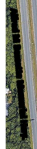


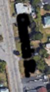
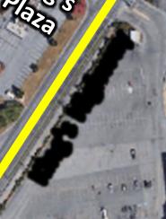
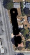
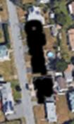

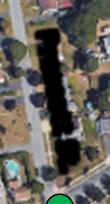
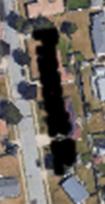
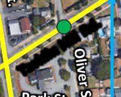
7 King s Highway Improvements 0309_ N End Project Start Project Signalized Intersection Un-Signalized Intersection Project Location Map City of New Bedford, Massachusetts King s Highway Improvements Project
8 Project Location and Limits Although the entire project comprises of phasing and timing adjustments including those at the intersection of Kings Highway and Mount Pleasant Street; the roadway improvements begin at the joint of the Kings Highway bridge over Route 140 (Bridge #N W3-DOT-NBI) and extends northerly to the intersection at Church Street, a distance of approximately 2,700 feet (0.55 miles). The project limits are illustrated in Figure 2.1 Study Area Locus map. Project Purpose The primary goals of this project are to improve capacity and safety along Kings Highway from the intersections of Church Street/Park Avenue and Tarkiln Hill Road/Church Street to Route 140 Bridge over Kings Highway (Bridge #N W3-DOT-NBI). The project goals will be achieved by design tasks such as; providing exclusive left-turn lanes at identified intersections as well as updated lane designations, improved phasing and signal timings, bicycle accommodation, Americans with Disabilities Act and Architectural Access Board (ADA/AAB) compliant sidewalks, ramps and crosswalks. The asphalt pavement will be rehabilitated with a mix of widening, full depth reconstruction, and pavement milling and overlay. Existing Conditions According to the Office of Transportation Planning, Kings Highway is classified as an urban minor arterial that serves as a major east-west link providing direct connection to Route 140. For the purposes of this project, Kings Highway is referred to as a north-south roadway. The existing typical section of Kings Highway for the length of this project consists of two 11-foot lanes in each direction with curbing on both sides. There is no shoulder on either side of Kings Highway within the project limits. The east side of Kings Highway has concrete and bituminous sidewalk that varies in width and at some locations is separated from the travel way by a grass buffer. Guardrail exists on both sides of roadway on the approaches to the bridge above Route 140, and also on the east side of the roadway adjacent to shopping plaza parking lot. The existing sidewalks are in fair to poor condition. Ramps at the intersections and driveways are either missing, or do not meet ADA/AAB requirements. Sidewalks only exist on the east side of Kings Highway with the exception of sidewalk on the west side on the bridge over Route 140. Existing shoulders are insufficient to provide bicyclist accommodation. Kings Highway is intersected by six streets within the project limits which include; Fieldstone Marketplace, Route 140 North Ramps, Kings Plaza Shopping Center, Tarkiln Hill Road, Worcester Street/Park Avenue, and Church Street. Mount Pleasant Street/Jones Street and Kings Highway The limits of the current project area end at the Route 140 Bridge over Kings Highway (Bridge #N W3-DOT-NBI) which is located just north of the Kings Highway/Mount Pleasant Street intersection. However, the traffic signals along Kings Highway at the intersections of Fieldstone Marketplace, Route 140 Ramps and Kings Plaza Shopping Center currently operate in coordination with the signal at the Kings Highway/Mount Pleasant Street intersection.
9 The Mount Pleasant Street westbound approach consists of a shared left-turn/through lane and a channelized right turn lane operating under yield control. The Mount Pleasant Street eastbound approach consists of an exclusive left-turn lane and a through/right-turn lane. The Jones Street northbound approach serves a residential area and consist of one shared left/through/right-turn lane. The Kings Highway southbound approach include a shared left-turn/through lane and an exclusive right turn lane. Crosswalks are provided across the southbound and westbound approaches to the intersection. East of the intersection, sidewalks are provided on both sides of Mount Pleasant Street, while west of the intersection, sidewalks are present on just the north side of Mount Pleasant Street. Sidewalks are present on both sides of the Kings Highway approach to the intersection. Fieldstone Marketplace and Kings Highway The Fieldstone Marketplace and Kings Highway intersection is a three-way signalized intersection. The westbound approach provides access to Fieldstone Marketplace, and consists of an exclusive left turn lane and an exclusive right-turn lane. The northbound Kings Highway approach consists of a through lane, and an exclusive right-turn lane. The southbound approach has an exclusive left-turn lane, and a through lane. Sidewalks exist on the eastern section of the intersection with wheelchair ramps. There are no striped crosswalks or detectable warning strips on the ramps. The signals are mounted on mast arms, and no pedestrian signals are present. Route 140 North Access Ramps and Kings Highway This is a three-way intersection operating under signalized control. The western segment of the intersection consists of an entrance ramp and an exit ramp to/from Route 140 North. The eastbound approach consists of an exclusive left-turn lane, and a channelized right-turn lane under yield control. The northbound approach has two lanes, a shared left-turn/through lane, and a through lane. The southbound approach has two through lanes, and a channelized right-turn lane under yield control. The existing traffic signal heads are mounted on mast arms. There are no pedestrian accommodations at this intersection. The stop bars for each approach are faded while the rest of the striping is in fair condition. Kings Plaza Shopping Center and Kings Highway This four-way intersection currently operates under signalized control. While the westbound approach provides access to Kings Plaza Shopping Center, the eastbound approach provides access to Stop & Shop and Citizens Bank. The westbound approach has two lanes which include an exclusive left-turn lane, and a shared through/right-turn lane. The eastbound approach has a shared left turn/through lane and an exclusive right-turn lane. Both the northbound and southbound approaches on Kings Highway have a shared left-turn/through lane, and a shared through/right-turn lane. Pavement markings on Kings Highway at this location are in poor condition including a completely faded crosswalk across the southbound approach. Wheelchair ramps exist on both sides of this crosswalk with pedestrian push buttons.
10 Tarkiln Hill Road and Kings Highway Tarkiln Hill Road and Kings Highway is a three-way unsignalized intersection. The eastbound Tarkiln Hill Road approach operates under stop control, while Kings Highway operates freely. The eastbound approach has a shared left/through/right-turn lane. The northbound approach of Kings Highway has a shared left-turn/through lane, and a through lane, while the southbound approach has a through lane, and a shared through/right-turn lane. Lane designations at this intersection are difficult to interpret due to the poor condition of pavement markings in this area. Bituminous sidewalk exists on the south side of Tarkiln Hill Road, and on both sides of Kings Highway to the south of the intersection. Sidewalks are present only on the east side of Kings Highway north of the intersection. The sidewalk on Kings Highway is in poor condition, and the intersection does not include any crosswalks and wheelchair ramps. Worcester Street/Park Avenue and Tarkiln Hill Road This intersection is a four-way unsignalized intersection with Tarkiln Hill Road on the northsouth approaches, Worcester Street on the western approach, and Park Avenue on the eastern approach. Worcester Street is presumably under stop control although a stop sign is not posted on the approach. Park Avenue is a one-way street that carries traffic away from the intersection. Both approaches for Tarkiln Hill Road consist of a shared left-turn/through lane and a through/right-turn lane, and the Worcester Street eastbound approach has a shared leftturn/through/right-turn lane. Pavement markings are in poor condition at this intersection. Bituminous sidewalk exists on the west side of Tarkiln Hill Road and the south side of Worcester Street. There are no wheelchair ramps at this intersection. Church Street and Tarkiln Hill Road The four-way intersection of Church Street and Tarkiln Hill Road operates under signal control. The westbound approach of Church Street consists of an exclusive left-turn lane, and a shared through/right-turn lane. The eastbound approach of Church Street consists of a shared left turn/through lane, and an exclusive right-turn lane. The northbound and southbound approaches on Tarkiln Hill Road have an exclusive left-turn lane, and a shared through/right-turn lane. The existing traffic signals are pedestal mounted, on each corner of the intersection. Bituminous sidewalk exists on both sides of the eastbound section of Church Street and on the west side of Tarkiln Hill Road south of the intersection. Concrete sidewalk exists on both sides of Tarkiln Hill Road north of the intersection. Pavement markings are in fair condition. Each corner has a pedestrian signal head and push button however, there are no crosswalk markings or wheelchair ramps. Church Street and Park Avenue This is a four-way unsignalized intersection where Church Street movements operate freely and Park Avenue movements are under STOP control. South of the intersection, Park Avenue is a one-way northbound street and converts to a two-way street north of the intersection. All approaches to the intersection presumably consist of one shared lane, as clear lane configuration markings are not provided. The northbound Park Avenue approach and the Church Street approaches are 20 feet or greater in width. Sidewalks, crosswalks and wheelchair ramps are not provided at this intersection.
11 Longitudinal pavement markings exist throughout the length of the project. Pavement markings are in fair to poor condition. There are faded crosswalks at the intersection of Tarkiln Hill Rd at Worcester Street/Park Avenue, as well as a completely faded crosswalk at the intersection of Kings Plaza at Kings Highway. From the intersection of Kings Plaza Shopping Center to Church Street, pavement markings along Kings Highway/Tarkiln Hill Road in general are exceptionally faded, making it difficult to interpret the existing lane configurations. Proposed Improvements Several improvements are being proposed in the area along the corridor and at each of the study intersections. Bicycle lanes are being proposed on both sides of Kings Highway from Fieldstone Marketplace to Church Street in conformance with Engineering Directive E ADA compliant pedestrian accommodation with exclusive pedestrian phases will be provided at all study area intersections including those at Fieldstone Marketplace, Route 140 North Ramps, Kings Plaza, and Church Street. New pavement markings and signing will be included in the project. Mount Pleasant Street at Kings Highway The limits of work for this project end just north of the intersection of Mount Pleasant Street and King s Highway. However, it is the intent of this project to improve operations at this intersection as well. Updated pavement markings are being proposed along southbound Kings Highway approach to this intersection. Kings Highway at Fieldstone Marketplace Improvements at the intersection of Fieldstone Marketplace and Kings Highway include new pavement markings, new sidewalks and corner ramps, upgraded traffic signals and timings. The upgraded traffic signal will have mast arm mounted signal heads, and operate on a closed loop coordinated system. The existing exclusive right turn lane on the northbound Kings Highway approach will be converted to a shared through/right-turn lane. Route 140 North Ramps at Kings Highway This intersection has multiple improvements proposed to enhance safety and capacity. A new driveway to the shopping plaza is proposed at this intersection. The driveway will form the westbound approach to the intersection. Widening is proposed at this location to provide an exclusive left-turn lane on the northbound and southbound approaches of Kings Highway with shoulders on both sides. The eastbound Route 140 ramp approach will be widened to provide two exclusive left turn lanes, a through lane and a shared through/right-turn lane. The traffic signal equipment will be upgraded with new signal heads and mast arm poles. New pavement markings are proposed as well as an improved pavement surface. The traffic signal phasing/timings will be updated and coordinated in a closed loop system.
12 Kings Plaza Shopping Center at Kings Highway Widening is proposed at this intersection to incorporate exclusive left-turn lanes on both approaches of Kings Highway. The new cross section on both approaches of Kings Highway will include a 5-foot shoulder, a shared through/right-turn lane, a through lane, and an exclusive left-turn lane. Both the eastbound and westbound driveway will consist of a shared leftturn/through lane and a shared through/right-turn lane. The sidewalk is proposed to be widened from 5.5 to 7.5 on the east side of Kings Highway south of the intersection. Church Street at Tarkiln Hill Road Widening is proposed at this intersection to incorporate exclusive left-turn lane, a through lane and a shared through/right-turn lane on the northbound Tarkiln Hill Road approach. The eastbound Church Street approach will be widened to include an exclusive left-turn lane and a shared through/right-turn lane. On the south-east corner of the intersection, width along Park Avenue will be narrowed down to one lane. Please note that per directive from MassDOT, the crosswalk across Tarkiln Hill Road that is located at about 200 feet south of Church Street intersection is being removed. Traffic signal phasing for the left turn movements at this location will be revised to include protected and protected/permissive phases. Traffic Management Traffic will be maintained along all streets throughout construction. Right of Way The existing layout along Kings Highway varies throughout the project limits. The typical width along Kings Highway north of Route 140 intersection based on the existing City Layout is about 66 feet. Based on the state highway layout line, the State owns the parcel of land located on the west side of Kings Highway, south of Route 140 intersection. However north of the Route 140 intersection, the right of way belongs to the City of New Bedford.
13 THE COMMONWEALTH OF MASSACHUSETTS MASSACHUSETTS DEPARTMENT OF TRANSPORTATION HIGHWAY DIVISION FEDERAL AID PROJECT New Bedford, MA King s Highway Improvements Project Project File No This sheet is provided for your comments. Your input is solicited and appreciated. Please return your sheet, with comments, to a staff member at the meeting, or mail to: Patricia A. Leavenworth, P.E., Chief Engineer MassDOT Highway Division 10 Park Plaza, Boston, MA Attn: Roadway Project Management The final date for receipt of written statements and exhibits for inclusion into the official hearing transcript will be ten (10) days after the Public Hearing. PLEASE TYPE OR PRINT LEGIBLY. Name: Title: Organization: Address:
14 Please Fold and Tape Please Place Appropriate Postage Here Patricia A. Leavenworth, P.E. Chief Engineer MassDOT Highway Division 10 Park Plaza Boston, MA RE: Public Hearing King s Highway Improvements Project NEW BEDFORD Project File No Roadway Project Management
Paul Huston, P.E., Design-Build Coordinator Chuck Gonderinger, HDR Engineering. Minnesota Department of Transportation (the Department)
") To: From: Paul Huston, P.E., Design-Build Coordinator Chuck Gonderinger, HDR Engineering Date: March 20, 2001 Subject: Roadway Geometric Design Criteria Project: TH 14/218 Design-Build Project, SP 7408-29,
To: From: Paul Huston, P.E., Design-Build Coordinator Chuck Gonderinger, HDR Engineering Date: March 20, 2001 Subject: Roadway Geometric Design Criteria Project: TH 14/218 Design-Build Project, SP 7408-29,
City of Madison, East Johnson Street North Baldwin Street to First Street Local Street Dane County
 City of Madison, East Johnson Street North Baldwin Street to First Street Local Street Dane County Public Involvement Meeting Thursday, November 10, 2016 5:30 to 7 P.M. Festival Foods 810 E. Washington
City of Madison, East Johnson Street North Baldwin Street to First Street Local Street Dane County
 City of Madison, East Johnson Street North Baldwin Street to First Street Local Street Dane County Public Involvement Meeting Thursday, April 28, 2016 6 to 8 P.M. Lapham Elementary School 1045 E. Dayton
Project Overview. Rolling Road Widening Fairfax County. Get Involved. Design Public Hearing. Contact Information
 Get Involved VDOT representatives will review and evaluate information received as a result of this meeting. Please fill out the comment sheet provided in this brochure if you have any comments or questions.
Final Sidewalk Feasibility Study
 Garfield Drive From Anastasia Drive to Elizabeth Place City of South Daytona July 23, 2009 Final Sidewalk Feasibility Study Prepared for: Prepared by: Final Sidewalk Feasibility Study Garfield Drive 2
Cycle Track Design Best Practices Cycle Track Sections
 Design Best Practices Sections It is along street segments where the separation and protection methods of cycle tracks offer more comfort than conventional bicycle lanes, and are more attractive to a wide
Corporate. Report COUNCIL DATE: May 25, 1998 NO: R1500 REGULAR COUNCIL. TO: Mayor & Council DATE: April 27, 1998
 R1500 : Traffic Safety at 25 Avenue and 128 Street Intersection Corporate NO: R1500 Report COUNCIL DATE: May 25, 1998 REGULAR COUNCIL TO: Mayor & Council DATE: April 27, 1998 FROM: General Manager, Engineering
Glenn Avenue Corridor Traffic Operational Evaluation
 Glenn Avenue Corridor Traffic Operational Evaluation PREPARED FOR: THE CITY OF AUBURN PREPARED BY: DECEMBER 2007 Glenn Avenue Corridor Study--Auburn, Alabama TABLE OF CONTENTS Introduction... 1 Background
Highway 49, Highway 351 and Highway 91 Improvements Feasibility Study Craighead County
 Highway 49, Highway 351 and Highway 91 Improvements Feasibility Study Craighead County Executive Summary March 2015 Highway 49, Highway 351 and Highway 91 Improvements Feasibility Study Craighead County
CHAPTER 16 PEDESTRIAN FACILITIES DESIGN AND TECHNICAL CRITERIA TABLE OF CONTENTS
 CHAPTER 16 PEDESTRIAN FACILITIES DESIGN AND TECHNICAL CRITERIA TABLE OF CONTENTS Section Title Page 16.1 General... 16-1 16.1.1 AASHTO Reference... 16-1 16.1.2 ADA Requirements... 16-1 16.2 Sidewalks...
DEPARTMENT OF ENVIRONMENTAL SERVICES. North Harrison Street (Lee Highway to Little Falls Road) Comparative Analysis. Prepared for:
 Comparative Analysis. Prepared for:") DEPARTMENT OF ENVIRONMENTAL SERVICES North Harrison Street (Lee Highway to Little Falls Road) Comparative Analysis Prepared for: Arlington County Department of Environmental Services 2100 Clarendon Boulevard,
DEPARTMENT OF ENVIRONMENTAL SERVICES North Harrison Street (Lee Highway to Little Falls Road) Comparative Analysis Prepared for: Arlington County Department of Environmental Services 2100 Clarendon Boulevard,
Legislative Update Williamsburg Residency
 Hampton Roads District Legislative Update Williamsburg Residency Jim Brewer, Resident Administrator 757-253-5140 Projects Under Way Warwick Boulevard Project http://www.warwickboulevard.org/ Contractors:
Multi-Modal Traffic Analysis. Parisi and Associates
 Mill Valley to Corte Madera Bicycle and Pedestrian Corridor Study Appendix D: Multi-Modal Traffic Analysis Prepared by Parisi and Associates August 2009 Appendix D - Multi-Modal Traffic Analysis Table
S.R. 3009, Section A20 South Park & Logan Road Intersection Improvement Project
 Open House Public Meeting S.R. 3009, Section A20 South Park & Logan Road Intersection Improvement Project Municipality of Bethel Park, Allegheny County Bethel Park Municipal Building 5001 West Library
ROAD SAFETY AUDIT. May 18, Prepared For: MassDOT. On Behalf Of: Town of Milford
 ROAD SAFETY AUDIT East Main Street (Route 16) at Medway Road (Route 109), East Main Street (Route 16) at Quarry Square Driveways, East Main Street (Route 16) at Beaver Street/ Fortune Boulevard Town of
Fairfax County Parkway Widening Fairfax County
 Get Involved VDOT representatives will review and evaluate information received as a result of this meeting. Please fill out the comment sheet provided in this brochure if you have any comments or questions.
ADA PRESENTATION (CURB RAMPS)
") ADA PRESENTATION (CURB RAMPS) ACECNJ/NJDOT/FHWA DESIGN SUMMIT Warren Howard New Jersey Department of Transportation May 21, 2013 ADA Curb Ramps NJDOT wants curb ramps to be designed & constructed properly
ADA PRESENTATION (CURB RAMPS) ACECNJ/NJDOT/FHWA DESIGN SUMMIT Warren Howard New Jersey Department of Transportation May 21, 2013 ADA Curb Ramps NJDOT wants curb ramps to be designed & constructed properly
Summary: Mercer County Princeton Avenue & Spruce Street Study January 2009
 Summary: Several recent studies have assessed potential development and redevelopment opportunities in the Mercer Crossing area of Trenton, Ewing, and Lawrence. This Princeton Avenue and Spruce Street
City of Scotts Valley CITY COUNCIL STAFF REPORT
 DATE: April 19, 2017 City of Scotts Valley CITY COUNCIL STAFF REPORT AGENDA ITEM 2 DATE: 4-19-2017 TO: FROM: APPROVED: SUBJECT: Honorable Mayor and City Council Scott Hamby, Public Works Director Jenny
Washington St. Corridor Study
 FIGURE 7.17 Bridge Alternatives - Cross Sections 86 Discarded Alternative: Short-Term Bridge Repair Short-term repairs and west bridge span replacement were considered during analysis. Short-term repairs
Accommodating Pedestrians in the Work Zone
 Accommodating Pedestrians in the Work Zone Guidance for Section C Plan Preparers Some impacts cannot be avoided and those impacts apply to residents, businesses, motorists, and pedestrians alike. However,
Description: Widen I-64 to 6 lanes from I-265 to the KY 53 interchange in Shelby County.
 I-64 KIPDA ID # 350 Project Type: ROADWAY CAPACITY Description: Widen I-64 to 6 lanes from I-265 to the KY 53 interchange in Shelby County. Purpose: Project will improve capacity and address safety concerns.
Complete Streets Funding Program Project Prioritization Plan
 Funding Program Project Prioritization Plan Location and Type Needs South Street Crosswalk Installation Stripe a new formalized crosswalk across South Street at the Anne T. Dunphy School pedestrian path
Americans with Disabilities Act Transition Plan for Public Right-of-Way Improvements
 Americans with Disabilities Act Transition Plan for Public Right-of-Way Improvements Prepared by: Public Works Department Engineering Division October 2015 Table of Contents Section I Introduction.. 3
TRAFFIC ACTION PLAN. Laurie Meadows Neighborhood CITY OF SAN MATEO
 TRAFFIC ACTION PLAN Laurie Meadows Neighborhood CITY OF SAN MATEO Draft January 2017 Table of Contents Introduction... 2 The Traffic Forum Process... 5 Neighborhood Traffic Issues... 7 Neighborhood Recommendations
ONONDAGA CREEKWALK PHASE II. Public Hearing Series 3
 ONONDAGA CREEKWALK PHASE II Public Hearing Series 3 Andrew Maxwell Director of Policy and Innovation, City of Syracuse Owen Kerney Assistant Director for City Planning Russell Houck, PE City of Syracuse
4APNOIPF Vh, YII PTC CITY COUNCIL AGENDA REPORT. Honorable Mayor and City Council Members. 8K TH 63 River Crossing Bridge Replacement Project
 City of RE 4APNOIPF Vh, X` W\ YII PTC ING, CITY COUNCIL AGENDA REPORT Council Meeting Date: September 26, 2016 To: From: Agenda Item: Honorable Mayor and City Council Members Ron Rosenthal, Engineering
Gwinnett County Department of Transportation SR 324 / Gravel Springs Road at I-85 / SR 403 Interchange Project Number F , PI No.
 June 4, 2015 Dear Resident: Thank you for attending this public information meeting for the proposed SR 324 / Gravel Springs Road at I-85 Interchange. The purpose of this meeting is two-fold: to provide
Meadow Woods Elementary School
 Drag and drop pic and stretch/crop to the limits of the blue rectangle (delete this text box) Meadow Woods Elementary School Drag and drop pic and stretch/crop to the limits of the blue rectangle (delete
Building Great Neighbourhoods BELLEVUE AND VIRGINIA PARK
 Building Great Neighbourhoods BELLEVUE AND VIRGINIA PARK This is Meeting 2 Unfortunately, some residents in Bellevue and Virginia Park received the wrong information for this public open house (Meeting
ADA on Construction. Guidance for Section C Plan Preparers
 ADA on Construction Guidance for Section C Plan Preparers Some impacts cannot be avoided and those impacts apply to residents, businesses, motorists, and pedestrians alike. However, good planning can minimize
Readington Road (C.R. 637) Construction
 Construction") Public Information Meeting Thursday, August 2, 2012 Readington Road (C.R. 637) Construction from Dreahook Road to Harlan School Road Branchburg Township, Somerset County Readington Township, Hunterdon
Public Information Meeting Thursday, August 2, 2012 Readington Road (C.R. 637) Construction from Dreahook Road to Harlan School Road Branchburg Township, Somerset County Readington Township, Hunterdon
Roadway Classification Design Standards and Policies. Pueblo, Colorado November, 2004
 Roadway Classification Design Standards and Policies Pueblo, Colorado November, 2004 Table of Contents Page Chapter 1. General Provisions 1.1 Jurisdiction 3 1.2 Purpose and Intent 3 1.3 Modification 3
5. MODIFICATIONS AT JEANNE D ARC BOULEVARD/REGIONAL ROAD 174 INTERCHANGE INTERSECTION - PUBLIC HEARING COMMITTEE RECOMMENDATION
 5. MODIFICATIONS AT JEANNE D ARC BOULEVARD/REGIONAL ROAD 174 INTERCHANGE INTERSECTION - PUBLIC HEARING COMMITTEE RECOMMENDATION Having held a public hearing, that Council approve the preliminary designs
4. ENVIRONMENTAL IMPACT ANALYSIS 9. TRANSPORTATION AND TRAFFIC
 4. ENVIRONMENTAL IMPACT ANALYSIS 9. TRANSPORTATION AND TRAFFIC 4.9.1 INTRODUCTION The following section addresses the Proposed Project s impact on transportation and traffic based on the Traffic Study
2011 Capital Projects University Area - Community Council Priority List Municipality of Anchorage
 2011 Capital Projects University Area - Community Council Priority List Municipality of Anchorage 2 Project Management and Engineering Projects on 40th Ave Extension - Lake Otis Pkwy to Dale St $18,103,000
Pedestrian Road Safety Audit
 Pedestrian Road Safety Audit Middlebrook Road From Father Hurley Boulevard to Waring Station Road December 2017 Montgomery County Department of Transportation Table of Contents 1. Introduction... 1 1.1
INGHAM COUNTY ROAD DEPARTMENT AUSTIN E. CAVANAUGH ADMINISTRATION BUILDING 301 Bush Street, P.O. Box 38, Mason, MI
 INGHAM COUNTY ROAD DEPARTMENT AUSTIN E. CAVANAUGH ADMINISTRATION BUILDING 301 Bush Street, P.O. Box 38, Mason, MI 48854-0038 March 27, 2018 William M. Conklin, P.E. Managing Director FOR IMMEDIATE RELEASE:
CITY OF KASSON TRANSPORTATION ALTERNATIVES KASSON SAFE ROUTES TO SCHOOL
 ve ha 8t G B A Mantorville Ave N 240th Ave 16th St NE 11th Ave NE K-M HIGH SCHOOL SUNRISE TRAIL TO MANTORVILLE MNTH 57 SUNSET TRAIL TO MANTORVILLE NE PARK 16TH ST NE TRAIL K-M ELEMENTARY SCHOOL K-M MIDDLE
ROAD SAFETY AUDIT. Blue Hill Avenue (Route 28) and Warren Street High Crash Locations City of Boston. November 1, 2016
 and Warren Street High Crash Locations City of Boston. November 1, 2016") ROAD SAFETY AUDIT Blue Hill Avenue (Route 28) and Warren Street High Crash Locations City of Boston November 1, 2016 Prepared For: MassDOT Highway Division Prepared By: BETA Group, Inc. Table of Contents
ROAD SAFETY AUDIT Blue Hill Avenue (Route 28) and Warren Street High Crash Locations City of Boston November 1, 2016 Prepared For: MassDOT Highway Division Prepared By: BETA Group, Inc. Table of Contents
Route 47 (North Main Street) Reconstruction
 Reconstruction") TOWN OF SUNDERLAND Route 47 (North Main Street) Reconstruction Presented by Lou Rabito, P.E. Presented to Town of Sunderland June 11, 2018 Project Overview MassDOT Project No. 607245 Resurfacing and Related
TOWN OF SUNDERLAND Route 47 (North Main Street) Reconstruction Presented by Lou Rabito, P.E. Presented to Town of Sunderland June 11, 2018 Project Overview MassDOT Project No. 607245 Resurfacing and Related
Clyde Brown Elementary School Millis, MA
 Clyde Brown Elementary School Millis, MA Transportation Assessment August 8, 2017 Prepared for: Tappe Architects Six Edgerly Place Boston, MA 02116 Submitted by: Nitsch Engineering 2 Center Plaza, Suite
Route 117 Review of Ownership Transfer October 2014
 Route 117 Review of Ownership Transfer October 2014 Page 1 of 27 I. INTRODUCTION... 3 II. EXISTING CONDITIONS... 4 A. Town of Lancaster Site-Investigation... 4 B. Town of Bolton Site-Investigation... 9
State Street and Pierce Park Lane Intersection Concept Report
 State Street and Pierce Park Lane Intersection Prepared for September 2017 Prepared by CITATION Parametrix. 2017. State Street & Pierce Park Lane Intersection. Prepared by Parametrix, Boise, ID. September
Date: April 4, Project #: Re: A Street/Binford Street Traffic/Intersection Assessment
 To: Peter Cavanaugh General Electric From: David Bohn, PE Ryan White, PE Date: April 4, 217 Project #: 13421. Re: / Traffic/Intersection Assessment Consistent with the Cooperation Agreement between the
COMMITTEE RECOMMENDATIONS. That Council approve:
 4. MODIFICATIONS TO INNES ROAD (REGIONAL ROAD 30) AND TENTH LINE ROAD (REGIONAL ROAD 47) TO ACCOMMODATE THE DEVELOPMENT OF THE TRINITY COMMONS SHOPPING CENTRE COMMITTEE RECOMMENDATIONS That Council approve:
Designing Pedestrian Facilities for Accessibility. Module 8 Maintenance of Pedestrian Facilities and Alternate Pedestrian Access Routes in Work Zones
 Designing Pedestrian Facilities for Accessibility Module 8 Maintenance of Pedestrian Facilities and Alternate Pedestrian Access Routes in s Maintenance of Accessible Features Title II (28 CFR 35.133(a))
Hidden Oaks Elementary School
 Hidden Oaks Elementary School SCHOOL ROUTE PLAN For HIDDEN OAKS ELEMENTARY SCHOOL LOCATION 13 ORANGE COUNTY Prepared for: ORANGE COUNTY SCHOOL ASSESSMENT PROGRAM ORANGE COUNTY PUBLIC WORKS Traffic Engineering
sm1 CDMth '}lf!j1i!~~!2q[ ROAD SAFETY AUDIT County Street City of New Bedford March 22, 2017 Prepared For: MassDOT
 ROAD SAFETY AUDIT County Street City of New Bedford March 22, 2017 '}lf!j1i!~~!2q[ ~ j ighway Divl.sion Prepared For: MassDOT On Behalf Of: City of New Bedford Massachusetts Prepared By: CDM Smith 260
Design Public Hearing MassDOT Project # February 19, 2015 Chatham Town Hall Annex 7:00 P.M.
 Design Public Hearing MassDOT Project #606596 February 19, 2015 Chatham Town Hall Annex 7:00 P.M. Overview Process to date Project goals Data collection results Existing conditions Alternative analysis
Complete Streets Needs. Complete Streets Project Origin (planning documentation or supporting analysis)
") Mobility MassDOT Program Project Prioritization Plan (Revised 3/31/16) Municipality Winchendon 7/25/2017 Location Needs Request Schedule 1 Development of roundabout at the intersection of Front Street
Mobility MassDOT Program Project Prioritization Plan (Revised 3/31/16) Municipality Winchendon 7/25/2017 Location Needs Request Schedule 1 Development of roundabout at the intersection of Front Street
Typical Cross Section: DOWNTOWN (Observer Highway - 8th Street)
") Typical Cross Section: DOWNTOWN (Observer Highway - 8th Street) DRAFT SEPTEMBER 23, 14 1 Washington Street Typical Block Downtown Typical Block: DOWNTOWN (Observer Highway - 8th Street) New crosswalks
Typical Cross Section: DOWNTOWN (Observer Highway - 8th Street) DRAFT SEPTEMBER 23, 14 1 Washington Street Typical Block Downtown Typical Block: DOWNTOWN (Observer Highway - 8th Street) New crosswalks
July 5, Arthur R. Ware, Jr. Elementary School 2017 Safe Routes to School Walkabout Report
 July 5, 2017 Arthur R. Ware, Jr. Elementary School 2017 Safe Routes to School Walkabout Report 1 Walkabout Report Introduction On April 28, 2017, City, School, and SAWMPO staff met to conduct a Safe Routes
Clay Street Bridge Replacement Project
 Clay Street Bridge Replacement Project Frequently Asked Questions (FAQs) The project is located in downtown Placerville on Clay Street between US Highway 50 and Main Street and Cedar Ravine Road. The proposed
Water Street Promenade Engineering and Design Services
 Preliminary Design Presentation Parking & Traffic Safety Committee Water Street Promenade Engineering and Design Services July 16,2014 November 3, 2016 Education / Infrastructure / Innovation 1 Project
APPENDIX G: INTERSECTION NEEDS AT OKEECHOBEE BOULEVARD
 APPENDIX G: INTERSECTION NEEDS AT OKEECHOBEE BOULEVARD INTERSECTION NEEDS AT SR 7 and OKEECHOBEE BOULEVARD SR 7 Extension Project Development and Environment (PD&E) Study From Okeechobee Boulevard (SR
CTH M HIGHWAY PROJECT CTH Q to STH 113
 CTH M HIGHWAY PROJECT CTH Q to STH 113 PUBLIC INFORMATIONAL MEETING #3 Wednesday, May 25, 2005 Town of Westport Administration Building 5387 Mary Lake Road 6:00 p.m. to 8:00 p.m. PUBLIC INFORMATIONAL MEETING
2014/2015 BIKE ROUTE PLAN 83 AVENUE PROTECTED BIKE LANE
 About the Project 2014/2015 BIKE ROUTE PLAN The City of Edmonton is planning a major bike route on the south side of Edmonton. This bike route is one part of a plan to provide citizens with transportation
CITY OF OTTAWA ROADWAY MODIFICATION APPROVAL UNDER DELEGATED AUTHORITY
 RMA-2015-ATM-038 CITY OF OTTAWA ROADWAY MODIFICATION APPROVAL UNDER DELEGATED AUTHORITY DATE: April 22, 2015 SUBJECT Approval of Roadway Modifications Recommended through an Area Traffic Management Study
Active Transportation Facility Glossary
 Active Transportation Facility Glossary This document defines different active transportation facilities and suggests appropriate corridor types. Click on a facility type to jump to its definition. Bike
FY STATEWIDE TRANSPORTATION IMPROVEMENT PROGRAM New Jersey Department of Transportation Projects
 ROUTE/ Project ID No. TIP No. Electrical Load Center Replacement - North 04324 04324 This project will provide for the betterment of the existing highway lighting facilities located along Routes 3, 17
Improvements Infrastructure Gap Assessment and Improvements Street Striping
 Infrastructure Project Proposal The federal-aid Safe Routes to School program funds infrastructure/engineering projects that fall into two categories: Design (available only to School Development Authority
Highway 111 Corridor Study
 Highway 111 Corridor Study June, 2009 LINCOLN CO. HWY 111 CORRIDOR STUDY Draft Study Tea, South Dakota Prepared for City of Tea Sioux Falls Metropolitan Planning Organization Prepared by HDR Engineering,
Appendix C. Bicycle Route Signage
 Appendix C Bicycle Route Signage This page intentionally left blank. APPENDIX C - BICYCLE ROUTE AND WAYFINDING SIGNAGE Bicycle route signs are wayfinding signs that guide bicyclists along preferred, designated
Institute for Real Estate Management Chapter (IREM) 77 VDOT Northern Virginia Megaprojects September 13, 2017
 77 VDOT Northern Virginia Megaprojects September 13, 2017") Institute for Real Estate Management Chapter (IREM) 77 VDOT Northern Virginia Megaprojects September 13, 2017 Susan Shaw, P.E., Megaprojects Director Virginia Department of Transportation Northern Virginia
Institute for Real Estate Management Chapter (IREM) 77 VDOT Northern Virginia Megaprojects September 13, 2017 Susan Shaw, P.E., Megaprojects Director Virginia Department of Transportation Northern Virginia
Lincoln Highway Streetscape Plan Concept Plan
 Lincoln Highway Streetscape Plan Concept Plan November 14, 2014 Introduction This report provides a summary of conceptual transportation, land use, and design recommendations in the Lincoln Highway Streetscape
Los Altos Hills Town Council - June 18, 2015 Palo Alto City Council June 22, AGENDA ITEM #2.B Presentation
 Los Altos Hills Town Council - June 18, 2015 Palo Alto City Council June 22, 2015 AGENDA ITEM #2.B Presentation Previous Presentations Los Altos Hills Town Council in May 2014 and February 2015 Palo Alto
AGENDA ITEM SUMMARY SPECIAL AGENDA ITEM NO. _1A_
 AGENDA ITEM SUMMARY AGENCY: City Council MEETING DATE: June 25, 2012 DEPARTMENT: Community Dev PREPARED BY: T Spade DEPT. DIR. APPROVAL: MJ CITY MGR. APPROVAL: LR PRESENTED BY: T Spade TITLE: RECEIVE REPORT
Act 47 Exception Application Process (Permitting Bicycle Travel on Freeways)
") Act 47 Exception Application Process (Permitting Bicycle Travel on Freeways) Attached is a revised application process to permit Pedalcycle travel on the shoulders of freeways within the Commonwealth.
Act 47 Exception Application Process (Permitting Bicycle Travel on Freeways) Attached is a revised application process to permit Pedalcycle travel on the shoulders of freeways within the Commonwealth.
Make Lincoln Highway an economically vibrant corridor that is safe, efficient, and beautiful for local residents and visitors.
 Lincoln Highway Streetscape Plan Stakeholder Workshop #2 Handout Contents Introduction and Project Vision Planning Principles Specific Recommendations including a Proposed Typical Roadway Section Renderings
Public Involvement Outreach Requirements for Public Information Open House Meeting: C.N , HSIP-5003(12) 132 nd and West Center Road, Omaha
 132 nd and West Center Road, Omaha") To: NDOR Environmental From: Randy McCart, HDR Date: 4 April 2017 RE: Public Involvement Summary Report, HSIP-5003(12) 132 nd and West Center Road, Omaha; C.N. 22629 Public Involvement Outreach Requirements
To: NDOR Environmental From: Randy McCart, HDR Date: 4 April 2017 RE: Public Involvement Summary Report, HSIP-5003(12) 132 nd and West Center Road, Omaha; C.N. 22629 Public Involvement Outreach Requirements
Legislative Update. Frederick County Fall Staunton District. Interstate 81 - Exit 300 at Interstate 66 Southbound Acceleration Lane Extension
 Interstate 81 - Exit 300 at Interstate 66 Southbound Acceleration Lane Extension Application ID 1643 Northern Shenandoah Valley Regional Commission (NSVRC) $3,437,423 This project extends the Interstate
Fleur Drive Reconstruction
 Fleur Drive Reconstruction October 29, 2018 1 Agenda: Fleur Drive Reconstruction Project Scope & Cost Overview Fleur Drive Cross Section Elements - Travel Lane Widths - Sidewalk Widths - Parkway Widths
WYDOT DESIGN GUIDES. Guide for. Non-NHS State Highways
 WYDOT DESIGN GUIDES Guide for Non-NHS State Highways 2014 GUIDE FOR Non-NATIONAL HIGHWAY SYSTEM (Non-NHS) STATE HIGHWAYS PRESERVATION REHABILITATION RECONSTRUCTION INTRODUCTION This Guide is directed to
ARTINSVILLE ENRY OUNTY REA RANSPORTATION TUDY
 ARTINSVILLE ENRY OUNTY REA RANSPORTATION TUDY DEVELOPED BY THE TRANSPORTATION AND MOBILITY PLANNING DIVISION OF THE VIRGINIA DEPARTMENT OF TRANSPORTATION IN COOPERATION WITH THE U.S. DEPARTMENT OF TRANSPORTATION,
01. VICINITY OF GREENBRAE POC: EXISTING CONDITIONS
 01. VICINITY OF GREENBRAE POC: EXISTING CONDITIONS Existing Bus Stop Existing US101 On-ramp Existing POC Old Redwood Highway Rich Street City ROW Environmental Study Limit Industrial Way NO DESIGNATED
Project Description Form 8EE
 Project Description Form 8EE Basic Project Information Submitting Jurisdiction/Agency: Town of Dumfries Project Title: Route 1 (Fraley Blvd) Widening: Brady's Hill Road to Dumfries Road Project Location:
TRASBURG RANSPORTATION
 TRASBURG RANSPORTATION LAN DEVELOPED BY THE TRANSPORTATION PLANNING DIVISION OF THE VIRGINIA DEPARTMENT OF TRANSPORTATION IN COOPERATION WITH THE U.S. DEPARTMENT OF TRANSPORTATION, FEDERAL HIGHWAY ADMINISTRATION
DEPARTMENT OF COMMUNITY PLANNING & BUILDING INTEROFFICE MEMORANDUM
 DEPARTMENT OF COMMUNITY PLANNING & BUILDING INTEROFFICE MEMORANDUM TO: VIA: VIA: VIA: FROM: DATE: SUBJECT: Board of County Commissioners Terry L. Shannon, County Administrator 11-5 Thomas Barnett, AICP,
Co-ordinator Transportation Committee. Director, Mobility Services and Corporate Fleet Services Environment and Transportation Department
 28 REGIONAL MUNICIPALITY OF OTTAWA-CARLETON MUNICIPALITÉ RÉGIONALE D OTTAWA-CARLETON REPORT RAPPORT Our File/N/Réf. Your File/V/Réf. 25 23-97-R016 DATE 15 April 1997 TO/DEST. FROM/EXP. SUBJECT/OBJET Co-ordinator
I-90 ALLSTON INTERCHANGE A MULTIMODAL TRANSPORTATION PROJECT MEPA CONSULTATION MEETING NOVEMBER 20, 2014 BRIGHTON HIGH SCHOOL
 I-90 ALLSTON INTERCHANGE A MULTIMODAL TRANSPORTATION PROJECT MEPA CONSULTATION MEETING NOVEMBER 20, 2014 BRIGHTON HIGH SCHOOL Today s Agenda 1. 2. 3. 4. 5. Overview of the MEPA Process Project Overview
5. RUNNINGWAY GUIDELINES
 5. RUNNINGWAY GUIDELINES These guidelines should be considered collectively when making runningway decisions. A runningway is the linear component of the transit system that forms the right-of-way reserved
Orange Center Elementary School
 Drag and drop pic and stretch/crop to the limits of the blue rectangle (delete this text box) Orange Center Elementary School Drag and drop pic and stretch/crop to the limits of the blue rectangle (delete
ARLINGTON COUNTY, VIRGINIA
 ARLINGTON COUNTY, VIRGINIA County Board Agenda Item Meeting of October 15, 2016 DATE: October 7, 2016 SUBJECT: Adoption of amendments to the Master Transportation Plan (MTP) to create a new Pedestrian
2014/2015 BIKE ROUTE PLAN 83 AVENUE PROTECTED BIKE LANE
 About the Project The City of Edmonton is planning a major bike route on the southside of Edmonton. The Strathcona Bike Route will connect the communities of Strathcona, Garneau and the University area,
OTTAWA TRAIN YARDS PHASE 3 DEVELOPMENT CITY OF OTTAWA TRANSPORTATION IMPACT STUDY. Prepared for:
 OTTAWA TRAIN YARDS PHASE 3 DEVELOPMENT CITY OF OTTAWA TRANSPORTATION IMPACT STUDY Prepared for: The Ottawa Train Yards Inc. 223 Colonnade Road South, Suite 212 Nepean, Ontario K2E 7K3 January 17, 2012
Traffic Impact Analysis
 Perkins Eastman Lowell High School Traffic Impact Analysis May 2017 640 George Washington Hwy Building C, Suite 100 Lincoln, RI 02865 401.722.7660 www.bryant-engrs.com This sheet is for double sided printing
Information on display. Inside this handout. Triangle Area revisions. Project need displays. Preferred alternative on aerial maps
 Public information meeting #4 4 to 7 p.m., September 30, 2009 Hales Corners Welcome Thank you for attending this public information meeting for the WIS 100 Corridor Study. Your interest and comments are
Executive Summary Route 30 Corridor Master Plan
 Route Corridor Master Plan Project Overview The Route Corridor Master Plan is a coordinated multimodal transportation and land use plan for the entire stretch of Route through East Whiteland Township,
SAN FRANCISCO MUNICIPAL TRANSPORTATION AGENCY
 THIS PRINT COVERS CALENDAR ITEM NO. : 10.3 DIVISION: Sustainable Streets Division BRIEF DESCRIPTION: SAN FRANCISCO MUNICIPAL TRANSPORTATION AGENCY Approving traffic and parking modifications to install
Bluffdale/ UDOT South High-T Intersection Project Type Operations
 Bluffdale/ UDOT 14600 South High-T Intersection Project Type Operations 14600 South and Redwood Road $ 600,000 $ 550,000 This project is to install a new High-T intersection at Redwood Road and 14600 South
INDUSTRIAL BUILDING 3009 HAWTHORNE ROAD CITY OF OTTAWA TRANSPORTATION OVERVIEW REVISED. Prepared for: Canada Inc.
 INDUSTRIAL BUILDING 3009 HAWTHORNE ROAD CITY OF OTTAWA TRANSPORTATION OVERVIEW REVISED Prepared for: 7849648 Canada Inc. Octiober 1, 2015 114-598 Overview_2.doc D. J. Halpenny & Associates Ltd. Consulting
MNDOT PAVEMENT DESIGN MANUAL
 MNDOT PAVEMENT DESIGN MANUAL Chapter 6 Ramps, Shoulders, Turn Lanes & Miscellaneous Pavements MnDOT Pavement Engineer Date Contents Introduction... 1 600 Ramps and Loops... 1 610 - Shoulders... 2 620 -
Steps to Conducting a Complete Streets Assessment
 Steps to Conducting a Complete Streets Assessment Familiarize yourself with Complete Streets Read through the Complete Streets Assessment Guidelines. This will give you an idea of what Complete Streets
1. Provide a dedicated westbound approach bus lane at the intersection;
 3. MODIFICATIONS AT HIGHWAY 417 WESTBOUND OFF-RAMP/PINCREST ROAD - PUBLIC HEARING COMMITTEE RECOMMENDATIONS Having held a public hearing, that Council approve the preliminary design for the proposed modifications
MEMORANDUM. Layout Of Study Intersections And Traffic Control
 BOSTON REGION METROPOLITAN PLANNING ORGANIZATION Richard A. Davey, MassDOT Secretary and CEO and MPO Chairman Karl H. Quackenbush, Executive Director, MPO Staff DATE November 15, 2012 TO FROM RE Town of
Brooklyn Boulevard (County Road 152) Reconstruction Project Phase I. OPEN HOUSE June 20, 2017
 Reconstruction Project Phase I. OPEN HOUSE June 20, 2017") Brooklyn Boulevard (County Road 152) Reconstruction Project Phase I OPEN HOUSE June 20, 2017 Brooklyn Boulevard (County Road 152) Phase I Project Partners Project Lead Other Project Partners include Brooklyn
Brooklyn Boulevard (County Road 152) Reconstruction Project Phase I OPEN HOUSE June 20, 2017 Brooklyn Boulevard (County Road 152) Phase I Project Partners Project Lead Other Project Partners include Brooklyn
The procedures to be followed in undertaking Non-Emergency work depend on the degree of traffic disruption caused by the work.
 APPENDIX G TRAFFIC CONTROL GUIDELINES FOR UTILITY WORK WITHIN ROADWAY RIGHTS- OF-WAY JUNE 2001 Scope of Guidelines These traffic control guidelines cover work performed by utility companies and/or their
Shore Drive Safety Task Force. Report to the SDAC
 Shore Drive Safety Task Force Report to the SDAC April 20, 2006 Table of Contents Introduction... 3 Section I Safety Recommendations... 5 Section II Communication/Public Involvement Plan... 14 Section
IMPLEMENTATION WORKBOOK
 Lawrence Township Bicycle and Pedestrian Planning Assistance Study IMPLEMENTATION WORKBOOK Final Action Plan - Part 2 April 2009 Prepared For: The Township of Lawrence and the New Jersey Department of