Proposed FUL-SR 66 Relocation on to CR 24. Presentation to Archbold Village Council April 17, 2017
|
|
|
- Phoebe Stewart
- 6 years ago
- Views:
Transcription


1 Proposed FUL-SR 66 Relocation on to CR 24 Presentation to Archbold Village Council April 17, 2017
2 Robert J. Seaman, P.E., P.S. Village Engineer Andrew J. Langenderfer, P.E. Sr. Project Manager
3 Agenda Stakeholders Project Location Past Steps Purpose and Need Feasibility Study Next Steps Questions


 Federal")

4 Stakeholders Village of Archbold, Ohio Local Public Agency (LPA) Ohio Department of Transportation (ODOT) Federal Highway Administration (FHWA) Fulton County, Ohio Henry County, Ohio
5 Project Location State Route 66 (SR 66) is an important north-south connection between US 20A and US 6, as well as to the Ohio Turnpike just north of the study area, in Fulton and Henry Counties in northwestern Ohio. SR 66 passes directly through the Village of Archbold. The Village of Archbold, in coordination with Fulton County and Henry County, is proposing to relocate SR 66 from downtown Archbold one mile to the west onto what is currently County Road 24 (CR 24), and to extend State Route 2 (SR 2) north of Archbold on to County Road E (CR E).
6 Past Steps 1960s: Representatives from the Village of Archbold first requested funding for a railroad grade separation and truck bypass on the west side of Archbold s & early 1990 s: Archbold elected leaders saw the need for an Industrial Park to attract new industry and jobs. A long term plan was to develop a way for trucks and employees to get in and out of the Industrial Park without having to deal with the very congested Defiance Street. 1998: An Ohio Turnpike interchange was opened on CR 24; immediately north of US 20A, SR 66 was relocated one mile west to CR 24 alignment to serve the new interchange. The intent of state and local officials at that time was to also relocate SR 66 on Fulton County (German Township)/Henry County Road 24 and Defiance County Domersville Road between US 20A and US 24 when funding would allow.
7 Past Steps (Continued) Local officials have long seen the need to address heavy truck traffic and commuter traffic through the Village of Archbold. 75% of those working in Archbold commute from 10 miles away. 2004: Village, Fulton County and German Township officials began working together to find a solution to alleviate trucks and traffic congestion in downtown Archbold. 2005: Archbold spent $2.6M to improve the downtown area and SR 66 from the Norfolk Southern railroad to the north corporation line. The project improved the turning radius at SR 2 and SR 66 as much as possible within the existing right of way. 2009: Nolan Parkway was extended to CR 24 to relieve congestion at the Defiance Street intersections and open up 57 acres for development.
8 Past Steps (Continued) : Concern with traffic congestion and safety increased after accidents involving semi-tractor trailers occurred in downtown Archbold at the intersection of SR66 & SR2. A meeting was held with village, township, and county representatives present. March of 2010: A meeting was held with ODOT to determine what type of improvements to Road 24 would be required to meet their standards should it become SR66 in the future. ODOT took pavement cores, determined the required improvements needed, and estimated the construction cost of the improvements from the Fulton/Henry County Line to US 20A. The Fulton County Engineer prepared a cost estimate based on ODOT s recommendations and estimates to improve the CR 24 corridor from US 6 to US 20A. One (1) mile of CR E was later included in the estimates in order for any proposed state highway relocations to be an even swap of mileage.
9 Past Steps (Continued) 2011: Elected and appointed officials from Fulton, Henry, and Defiance Counties, German Township, and the Village of Archbold met and agreed that the improvement of CR 24 was necessary and desirable from US 6 to US 20A. The Defiance County Commissioners were not interested in including Domersville Road in the proposed improvement. In support of the project, all the elected officials from these three counties, township, and village subsequently signed requests for a federal grant to improve CR 24 from US 6 to US 20A and to relocate SR 66 on said route.
10
11
12 Past Steps (Continued) Early 2013: The State Legislature adopted House Bill 51 (Transportation Budget and Turnpike Reform Plan). Among other things, this bill allowed the assets of the Turnpike to be leveraged by selling bonds to fund road and bridge projects that can show a nexus to the Turnpike. Archbold was made aware by the Fulton County Engineer that the Ohio Transportation Review Advisory Council (TRAC) would be accepting applications for projects that would include a direct nexus to the Ohio Turnpike. May of 2013: Archbold, with the assistance of the Fulton County Engineer, submitted an application to TRAC for funding and made a presentation at the TRAC meeting in Toledo outlining the proposed project and the safety and economic development benefits it would provide. The proposed project was subsequently awarded a $1.3M grant by ODOT using Federal Highway Administration (FHWA) funds to perform the Preliminary Engineering (PE) steps for the project. Archbold s Council authorized $200,000 towards the PE.
13 Past Steps (Continued) 2013: A Joint Board of Fulton and Henry County Commissioners was convened. A project site viewing was held and in February of 2014 the Joint Board held a public hearing and approved entering into an agreement with the Village of Archbold to be the lead agency for the proposed project. March of 2014: Archbold entered into a Joint Cooperation Agreement with the Fulton County Commissioners and the Henry County Commissioners to be responsible for the preparation of the initial construction plans, specifications, design and environmental phase of the project. May of 2014: Archbold entered into agreement with ODOT for the Preliminary Engineering/Environmental Study.
14 Past Steps (Continued) August of 2014: Letters of Interest (LOIs) were received from 7 well qualified consultants for the PE. The project team consisting of Archbold s Village Engineer, the Fulton County Engineer and the Henry County Engineer, with the assistance of ODOT District 2, reviewed and evaluated the LOIs. Tetra Tech was selected as the best qualified consultant for the proposed project. Late 2014: Due to concerns raised by the retail community, Archbold contracted with the Center for Regional Development from BGSU to perform an economic impact analysis of the project. The $28,000 study was completed in early 2015 and presented to the public. The analysis supported a positive economic growth for Archbold and northwest Ohio should the proposed project move forward. An executive summary of the economic study is available at
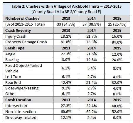
15
16
17 Past Steps (Continued) 2015: Archbold purchased and removed a building at the northwest corner of the SR 2 and SR 66 and widened the intersection. These projects however, did not reduce the number of trucks travelling through Archbold or the intersection of SR 2 and SR 66, and truck traffic has continued to increase downtown, as well as safety concerns. December of 2015: Archbold Council approved and entered into a contract with Tetra Tech for the Engineering Feasibility Study and Preliminary Environmental work as phase 1 of the PE steps. Archbold s Council authorized an additional $49,217 to include grade separation alternatives in the Feasibility Study. December 31, 2015: Tetra Tech was authorized to begin work.
18 PURPOSE AND NEED
19 PROJECT PURPOSE AND NEED Reduce truck traffic in the Village of Archbold Reduce congestion Reduce traffic crashes Serve current and future travel demand Provide a more direct route between: Ohio Turnpike and US 20A to the north US 6 and US 24 to the south
20 TRAVEL DEMAND From Turnpike - one mile east at US 20A Runs through downtown Archbold 5 signalized intersections At-grade railroad crossing Traffic Expected to Increase
21
22 CONGESTION SR 66 is one lane in each direction Volume is double to triple the volumes in the other areas in the study area Heavy truck traffic overcrowds the downtown street network Norfolk Southern (NS) crossing near Stryker Street (SR 2) 95 trains per day Blocked crossing an average of every 15 minutes daily (24 hours * 60 minutes/95 trains = 15 minutes/train occurrence) Trains expected to increase in the near future Any improvement account for 3 tracks at crossing
23 SAFETY 162 crashes along SR 66 (2013 to 2015) 95 crashes within the Village limits 10 were tractor trailer related 6 of the 10 at the intersection of Stryker Street (SR 2) in the downtown Truck crashes account for 1/3 of the overall crashes (18) at this location The desired outcome is to reduce the number of crashes along SR 66, especially through the Village of Archbold.
24
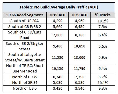
25
26 Feasibility Study Alternatives Traffic Analyses Roadway Assessment/Geotechnical Drainage Structure Type Assessments (Bridges) Culverts Grade Separation Study Right of Way Assessment Utility Assessment Environmental Analysis Comparison of Alternatives Conclusion/Recommendation
27 CR 25 CR 23 CR 24 CR 22 Ex. SR 66 CR 21 Alternatives Pre-screened Routes CR 21 CR 22 CR 23 (Ex. SR 66) CR 24 CR 25
28 Pre-screened Routes CR 21 Alignment Relocation two miles to the east Four miles longer than it is currently CR 22 Alignment Relocation of SR 66 one mile to the east, 2 miles longer than it is currently 2-mile gap in CR 22 between CR W and CR C Require 2 miles of new alignment or use CR 21-3, which is located 0.25 miles to the east If CR 21-3 was utilized, making SR 66 an additional 0.5 miles longer Existing SR 66 (No Build) Does not remove truck traffic from the downtown Prohibitive for a grade separation at the NS RR in downtown
29 Pre-screened Routes CR 24 Alignment Relocation one mile west of current SR 66 Provides a direct route from the Ohio Turnpike interchange to US 6 CR 25 Alignment Relocation 2 miles to the west, along TR 25 and CR Moves truck traffic 1 mile away from the Village limits 0.4 mile gap between the north end of CR 25 and the south end of CR 24-3, which would require the construction of new alignment. Floodplain of Branch 3 of the Tiffin River Require the construction of a new bridge crossing There are environmental impact concerns associated with the construction of 0.4 miles of new roadway through the floodplain with a new bridge crossing. CR 24 was further evaluated in the Feasibility Study

30 CR 24 TR E US 6
31 Alternatives No Build Maintain Existing SR 66 Build Relocate on to CR 24 and relocate SR 2 to TR E between existing CR 24 and existing SR 66 Alternative 1 Corridor Improvements with Roundabouts Alternative 2 Corridor Improvements with Stop Signs Alternative A - Grade Separation Underpass Alternative B - Grade Separation - Overpass Concrete Beams Alternative C - Grade Separation - Overpass with Steel Beams Alternative D - Grade Separation Bypass Alignment Overpass
32 Traffic Analyses BACKGROUND Rural major collector ADT 3,000s - 4,000s at the southern and northern ends ADT up to 13,000 through the Village of Archbold
33 Certified Traffic No Build Average Daily Traffic (ADT) SR 66 Road Segment 2019 ADT 2039 ADT % Trucks South of US 20A 4,290 4, % South of CR E/SR 2 5,660 6, % South of CR D/Lutz Road 7,060 8, % South of SR 2/Stryker Street 9,400 10, % South of Lafayette Street/W. Barre Street 11,230 13, % North of TR BC/Short Buehrer Road 10,150 11, % North of CR W 6,740 7, % North of SR 34 5,680 6, % North of US 6 3,420 3, % CR 24 Road Segment 2019 ADT 2039 ADT % Trucks South of US 20A 1,220 1, % South of CR E/SR 2 2,310 2, % South of CR D 3,230 3, % South of SR 2/Stryker Street 2,760 3, % North of TR BC/Short Buehrer Road 2,560 2, % North of SR 34 1,900 2, % North of US 6 1,530 1, %
34 Certified Traffic Truck Average Daily Traffic SR 66 Road Segment No Build Trucks Build Trucks Difference South of US 20A 14% 6.2% -7.8% South of CR E/SR 2 12% 4.2% -7.8% South of CR D/Lutz Road 10% 2.7% -7.3% South of SR 2/Stryker Street 5% 2.4% -2.6% South of Lafayette Street/W. Barre Street 5% 4.5% -0.5% North of TR BC/Short Buehrer Road 8% 3.4% -4.6% North of CR W 13% 4.9% -8.1% North of SR 34 11% 8.5% -2.5% North of US 6 6% 6% 0% CR 24 Road Segment 2019 No Build Trucks 2019 Build Trucks Difference South of US 20A 7% 13.9% +6.9% South of CR E/SR 2 3% 12% +9% South of CR D 2% 12.4% +10.2% South of SR 2/Stryker Street 6% 6% 0% North of TR BC/Short Buehrer Road 7% 9.6% +2.6% North of SR 34 3% 9.1% +6.1% North of US 6 3% 7.2% 4.2%
35 Operational Assessment Key Proposed Intersections Intersection Type Level of Service (LOS) SR 66/US 20A SR 66/TR E/SR 2 SR 66/CR D SR 66/SR 2/Stryker St SR 66/Lafayette St SR 66/TR BC/Short-Buehrer Rd SR 66/Nolan Pkwy SR 66/SR 34 SR 66/US 6 Old SR 66/SR 2 *Signal not warranted **Signal and AWSC not warranted #Was not evaluated Average Intersection Delay (Seconds) Roundabout A 7.2 Unsignalized (AWSC)* A 9.6 Unsignalized (TWSC) * B 14.7 Roundabout A 6.9 Unsignalized (TWSC) ** C 17.9 Roundabout A 6.7 Unsignalized (TWSC) ** B 13.9 Roundabout A 7.7 Unsignalized (AWSC)* B 10.4 Unsignalized (TWSC) * B 11.2 Roundabout A 7.8 Unsignalized (AWSC)* A 9.2 Unsignalized (TWSC) * B 11.1 Roundabout # # Unsignalized (TWSC) ** C 16.4 Roundabout # # Unsignalized (TWSC) ** B 13.6 Roundabout A 8.3 Unsignalized (AWSC)* B 10.5 Unsignalized (TWSC) * B 11.6 Roundabout A 7.8 Unsignalized (TWSC) * B 13.7 Roundabout A 6.1 Unsignalized (AWSC)* A 9.8 Unsignalized (TWSC) * C 16.9
36 Un-Signalized Intersections: US 6: Since US 6 experiences a long stretch of uncontrolled stops or yields, it is important to alert motorists of a new controlled intersection. Converting this intersection to AWSC does not provide a significant reduction in delay. Therefore, the two way stop control (TWSC) is proposed to remain at this intersection allowing US 6 to operate freely. SR 34: Although this intersection operates acceptably with TWSC (LOS C in 2019 and LOS D in 2039), the AWSC option does provide LOS B and reduced delay especially with future traffic volumes. Nolan Parkway: This intersection operates very well as is with TWSC with a slight decrease in delay with AWSC. It is recommended to keep the existing turn lanes and intersection control. Lafayette: This intersection operates very well as is with TWSC with a slight decrease in delay with AWSC. It is recommended that turn lanes be added, and TWSC be utilized with SR 66 operating freely. Ex. SR 2 (Stryker Street): This intersection operates very well as is with TWSC with a slight decrease in delay with AWSC. Due to the relocation of SR 2 to the north approach of the intersection, turning volumes will be redistributed. It is recommended that this intersection remain TWSC with the E-W route stop controlled, with SR 66 operating freely, and that turn lanes be added as warranted. The intersection can be easily converted to AWSC should future traffic warrant such a change.
37 Un-Signalized Intersections: CR D: This intersection operates very well as with TWSC with a slight decrease in delay with AWSC. It is recommended that turn lanes be added and TWSC be utilized on CR D to allow for free movement of SR 66. TR E / SR 2: This intersection operates very well as is with TWSC. It is recommended that turn lanes be added and TWSC be utilized with SR 66 operating freely. US 20A: This intersection operates very well as is with TWSC with a slight decrease in delay with AWSC. It is recommended to add turn lanes and use TWSC on SR 66 to maintain flow on US 20A. Ex. SR 66 / SR 2: This intersection operates well under normal non-tourist traffic conditions. Due to the location of Sauder Village just east of this intersection, there are periods of the year when traffic is heavier than normal and comprised of nonlocal visitors to the area. It is recommended to keep this intersection as is with TWSC, and to add turn lanes as warranted. It is also recommended to further study this intersection during the tourist seasons to determine if additional improvements or a change in traffic control may be warranted in the near future. This alternative will provide good LOS B or C for the corridor; however, with TWSC there remains the potential for severe and fatal accidents at many of the intersections along this corridor.
38
39
40
41
42 Roundabout Intersections: US 6 SR 34 Lafayette SR 2 (Stryker Street) CR D TR E (Proposed SR 2) US 20A TR E (Proposed SR 2) and CR 23 (Existing SR 66)
43
44
45
46

47 Roundabouts 300,000 signalized intersections in the US 2,300 people killed each year 700 people are killed annually in red-light running accidents By converting from a two-way stop control mechanism to a roundabout: 35 percent reduction in total crashes 76 percent reduction in injury crashes 89 percent reduction in fatalities Rural high speed arterials (55 MPH)


48 Roadway Assessment Evaluated Existing CR 24 Sight walk on July 6, 2016 Provided ODOT with pavement core photos and data, August 23, 2016 at ODOT s Typical Pavement Sections Reconstructed and widened areas: 1.5 of asphalt surface course 1.75 intermediate course 6 asphalt base material 6 aggregate base 14 cement stabilized subgrade Planing and Resurfacing varies based on ODOT recommendations
 and ODOT Pavement Design Manual 8 wide cement stabilized subgrade for")
49 Roadway Assessment Pavement Design: 400 spacing on borings California Bearing Ratio (CBR) of 5 was recommended for the project ODOT GB-1 (geotechnical SS) and ODOT Pavement Design Manual 8 wide cement stabilized subgrade for widening
50 Roadway Assessment Overlay and Widening Section
51 Roadway Assessment Cement Stabilization
52 Roadway Assessment Full Depth Reconstruction Section
53 Roadway Assessment CR 24 - asphalt surface materials. Pavement planing, and full depth replacement. It is recommended that asphalt pavement be used for this project to maximize cost and construction efficiencies, provide flexibility with variable wedging in planed sections, and to provide material continuity throughout the corridor. Roadside ditches
54 Structure Type Assessments Four structures (bridges) were evaluated: HEN (Existing HEN ) over Owl Creek HEN (Existing HEN ) structure over Ditch 1897 FUL (Existing FUL-T24A0-0090) Bridge over Brush Creek FUL (Existing FUL-C24G0-0020) Bridge over Branch No. 3 of the Tiffin River

55 HEN (Existing HEN ) over Owl Creek Existing Steel Beam Bridge Replace with pre-stressed concrete box beam structure

56 HEN (Existing HEN ) structure over Ditch 1897 Ex. 16 foot corrugated metal arch structure founded on concrete footings, constructed in Replace with 4 sided concrete box culvert

57 FUL (Existing FUL-T24A0-0090) Bridge over Brush Creek Ex. Steel Beam Bridge Replace with box beam structure This alternative is being recommended over replacing the bridge with a single span steel beam bridge reusing the existing galvanized steel beams, because the life cycle cost is lower.

58 FUL (Existing FUL-C24G0-0020) Bridge over Branch No. 3 of the Tiffin River Ex. concrete slab bridge Replace with concrete three sided culvert on spread footings
59 Culverts There are five additional culverts. All are recommended to be replaced with concrete box culverts and full height headwalls. FUL (existing FUL-T ) over Flat Run Tributary 2 (12 x 9 box) FUL (existing FUL-T24D N) over Flat Run (12 x 9 box) FUL (existing FUL-T24F N) over Grass Run (14 x 10 box) HEN over Unnamed Tributary to Coon Creek (6 x 5 box) HEN over Unnamed Tributary to Coon Creek (8 x 7 box)

60 GRADE SEPARATION STUDY Alternative A Underpass with a single span steel beam bridge for the railroad. Alternative B Overpass with a single span pre-stressed concrete beam bridge. Alternative C Overpass with a single span steel beam bridge.

61 Gerald Grain
62 Underpass $ M

63 Overpass B = $ M, C = $ M
64 Bypass Alternative D Bypass Overpass with a three span pre-stressed concrete beam bridge by relocating the roadway alignment to the west of the Gerald Grain Center. The abutments would consist of spillthrough type integral pile supported abutments. Both roadway approaches utilize fill slopes no retaining walls are required.

65 Bypass, D = $6.807M
66 GRADE SEPARATION STUDY Alternative D is recommended for separation: Cost Constructability (offline) Reduction in impacts to industrial and residential properties
67 Right-of-Way Assessment Existing right of way is 60 wide Proposed 100 right of way - equal widening (20 each side) Additional right of way at: Bridge/Culvert Crossings Intersections NS RR Grade Separation
68 ENVIRONMENTAL ANALYSIS Phase I History/Architecture Study Environmental Site Assessment Screening Ecological Survey Report Literature reviews and site visits
69 PUBLIC INVOLVEMENT Public meeting November 15, 2016 Notification letters from the Village and Consultant Response letters mailed and ed from the Village to public comment Information page is listed on documents and posted on Village s website with link to project documents
70 Who is leading this project, and who is paying for it? (See Responses #2 & 3 below) Ex. SR 66 Business Concerns (See response #1 below) Cost Concerns (See Response #2 below) Safety Concerns (See responses #4-9 below) Questions relating to traffic (See responses #4-6) Concerns of farmland/property value (See responses #1, 10 & 11 below) Questioning/Opposed to roundabouts (See responses #4, 7 & 8 below) Concerns to personal business (See responses #1 & 10 below) Concerns with maintenance of Ex. SR 66 (See response #14 below) Opposed to Grade Separation (See responses #9 & 12) Environmental concerns (See response #13 below) Removing truck traffic from Ex. SR 66 (See response #6 below) Economic Benefits (See response #1 below) Improved Safety (See response #6 below) Reduced Traffic Congestion (See response #6 below) Support for grade separation (See response #12 below) PUBLIC INVOLVEMENT General Questions/Comments of Opposition General Questions/Comments of Support TOTALS
71 COMPARISON OF ALTERNATIVES ALTERNATIVES EVALUATION 7 CRITERIA: Removes Trucks from Downtown Direct Connection between the Ohio Turnpike and US 6 Safety Considerations Operating Efficiency (LOS) Right-of-Way and Relocation Impacts Environmental Impacts Costs
72 1 2 Alternatives A B C D Conceptual Cost Type No Build CR 24 Corridor Improvements with Roundabouts CR 24 Corridor Improvements with Unsignalized Intersections CR 24 Grade Separation at NS RR - Underpass CR 24 Grade Separation at NS RR - Overpass with Concrete Beams CR 24 Grade Separation at NS RR - Overpass with Steel Beams CR 24 Grade Separation at NS RR Bypass Alignment Overpass Roadway $0 $9.212M $9.951M $2.236M* $1.434M* $1.434M* $2.181M** Bridge $0 $1.950M $1.950M $4.582M $1.908M $1.994M $2.300M Retaining Walls $ $2.500M $6.930M $6.930M -- Railroad Force Account $ $4.700M $0.400M $0.400M $0.400M Enclosed Drainage (ConAgra to Brush Creek) Roundabout Intersections (8) Unsignalized Intersections (10) Gerald Grain Center Impacts Construction Contingency 20% ODOT Escalation Factor of 16% (Construction 2020 to 2021) $0 $5.600M $5.600M $0 $5.398M $0 -- $2.657M $0 $1.020M $1.020M $1.020M*** $1.020M*** $1.020M*** -- $0 $4.492M $4.236M $3.008M $2.338M $2.356M $0.976M $0 $4.438M $4.192M $2.901M $2.292M $2.309M $0.950M Total**** $0 $32.110M $29.606M $20.947M $16.322M $16.443M $6.807M
73 Evaluation Criteria Removes Trucks from Downtown Provides for Direct Connection from Ohio Turnpike to US 6 Safety No Build Alternatives 1 2 A B C D CR 24 Corridor Improvements with Roundabouts CR 24 Corridor improvements with Unsignalized Intersections CR 24 Grade Separation at NS RR - Underpass CR 24 Grade Separation at NS RR - Overpass with Concrete Beams CR 24 Grade Separation at NS RR - Overpass with Steel Beams CR 24 Grade Separation at NS RR Bypass Alignment Overpass Does not remove trucks Removes most trucks Removes most trucks Removes most trucks Removes most trucks Removes most trucks Removes most trucks Does not provide direct connection; must travel east through downtown Right angle & severe accident potential Provides direct connection btw. Turnpike & US 6 Significant reduction in the potential for severe & fatal accidents Provides direct connection btw. Turnpike & US 6 TWSC does not improve the reduction in the potential for severe & fatal accidents Provides direct connection btw. Turnpike & US 6 Eliminates safety issues at RR crossing Provides direct connection btw. Turnpike & US 6 Eliminates safety issues at RR crossing Provides direct connection btw. Turnpike & US 6 Eliminates safety issues at RR crossing Provides direct connection btw. Turnpike & US 6 Eliminates safety issues at RR crossing Operating Efficiency (LOS) Some intersections warrant turn lanes and/or roundabout improvements LOS A LOS B and C LOS A LOS A LOS A LOS A R/W Acquisition & Relocations No R/W Acquisition Strip R/W along corridor & impacts to Gerald Grain Center property; one residential relocation Strip R/W along corridor & impacts to Gerald Grain Center property; one residential relocation Impacts to Gerald Grain Center property Impacts to Gerald Grain Center property & full acquisition & relocation of residential property Impacts to Gerald Grain Center property & full acquisition & relocation of residential property No impacts to Gerald Grain Center property Environmental No impacts Minor stream impacts, nationwide permit, no Section 4(f), no historic properties Minor stream impacts, nationwide permit, no Section 4(f), no historic properties Minor stream impacts, nationwide permit, no Section 4(f), no historic properties Minor stream impacts, nationwide permit, no Section 4(f), no historic properties Minor stream impacts, nationwide permit, no Section 4(f), no historic properties Minor stream impacts, nationwide permit, no Section 4(f), no historic properties Costs $0 $32.110M $29.606M $20.947M $16.322M $16.443M $6.807M Best Moderate Worst
74 CONCLUSION Alternative 1 is the recommended preferred option for the corridor improvements constructing roundabouts at key intersections. Alternative D (Bypass) is the recommended preferred option for a grade separation improvement
75 NEXT STEPS The next step in the Preliminary Engineering (PE) process will be ODOT s review of the final Feasibility Study Report, consideration of the no-build or build option(s), and Purpose and Need document. ODOT will use the Feasibility Study and Purpose and Need to help evaluate the proposed project s transportation needs, the positive and negative impacts caused by the proposed project and the public/agency concerns expressed on this proposed project. Should the Village of Archbold wish to advance the project, it will be at ODOT s discretion to proceed with completion of the PE steps for the proposed project if in ODOT s opinion, the transportation purpose and need is met, the benefits overcome the impacts, and the benefits to the general public overcome the public s concerns to the proposed project.
76 NEXT STEPS (Continued) Build or No-Build If Build, Then: For Corridor: Alternative 1 or Alternative 2 Or Variation of Either Alternative For Railroad: Grade Crossing or Separation If Grade Separation, Then: Alternative A, B, C or D
77 NEXT STEPS (Continued) Develop Stage 1, Stage 2, and Preliminary R/W plans Develop preliminary grade separation plans, if desired by the Village Public Meeting following completion of Stage 1 and Preliminary Right of Way Plans Secure Final Design, Right-of-Way and Construction Funding

78 QUESTIONS
SR 53 Corridor Study. Final Report Presentation. Friday, October 3, :00 AM to noon
 SR 53 Corridor Study Final Report Presentation Friday, October 3, 2014 10:00 AM to noon SR 53 Corridor Study Final Report Presentation Study Purpose: Investigate safety improvements along the SR 53 corridor
WYDOT DESIGN GUIDES. Guide for. Non-NHS State Highways
 WYDOT DESIGN GUIDES Guide for Non-NHS State Highways 2014 GUIDE FOR Non-NATIONAL HIGHWAY SYSTEM (Non-NHS) STATE HIGHWAYS PRESERVATION REHABILITATION RECONSTRUCTION INTRODUCTION This Guide is directed to
WYDOT DESIGN GUIDES. Guide for. NHS Arterial (Non-Interstate)
") WYDOT DESIGN GUIDES Guide for NHS Arterial (Non-Interstate) 2014 GUIDE FOR NATIONAL HIGHWAY SYSTEM (NHS) HIGHWAYS (NHS ARTERIALS, Non-Interstate) PRESERVATION REHABILITATION RECONSTRUCTION INTRODUCTION
WYDOT DESIGN GUIDES Guide for NHS Arterial (Non-Interstate) 2014 GUIDE FOR NATIONAL HIGHWAY SYSTEM (NHS) HIGHWAYS (NHS ARTERIALS, Non-Interstate) PRESERVATION REHABILITATION RECONSTRUCTION INTRODUCTION
JONESBORO HIGHWAY 63 HIGHWAY 18 CONNECTOR STUDY
 JONESBORO HIGHWAY 63 HIGHWAY 18 CONNECTOR STUDY Craighead County May 2007 JONESBORO HIGHWAY 63 HIGHWAY 18 CONNECTOR STUDY Craighead County May 2007 Prepared by Planning and Research Division Arkansas State
PROJECT NO. 093 MA 199 H C. FEDERAL NO. xxxx WIKIEUP-WICKENBURG-PHOENIX HIGHWAY TEGNER STREET, ALTERNATIVE 10 PROJECT IMPROVEMENT
 PROJECT NO. 093 MA 199 H 5807 01C FEDERAL NO. xxxx WIKIEUP-WICKENBURG-PHOENI HIGHWAY TEGNER STREET, ALTERNATIVE 10 PROJECT IMPROVEMENT (INTERSECTION IMPROVEMENT) US 93/US 60 FINAL PROJECT ASSESSMENT April
I-20 ODESSA-MIDLAND CORRIDOR STUDY. Public Meeting for Schematic Design
 I-20 ODESSA-MIDLAND CORRIDOR STUDY Public Meeting for Schematic Design The environmental review, consultation, and other actions required by applicable Federal environmental laws for this project are being,
Chapter 4 Traffic Analysis
 Chapter 4 Traffic Analysis PURPOSE The traffic analysis component of the K-68 Corridor Management Plan incorporates information on the existing transportation network, such as traffic volumes and intersection
Roundabout Feasibility Memorandum
 Roundabout Feasibility Memorandum To From Gwen Pipkin Bill Howell Date June 18, 2013 Subject Roundabout Feasibility Study SR 29 PD&E Study From Oil Well Road to SR 82 Collier County, FL FPID 417540-1-22-01
Fairfax County Parkway Widening Fairfax County
 Get Involved VDOT representatives will review and evaluate information received as a result of this meeting. Please fill out the comment sheet provided in this brochure if you have any comments or questions.
Sponsored by the Office of Traffic and Safety of the Iowa Department of Transportation NOVEMBER 2001 CTRE
 PAVED SHOULDERS ON PRIMARY HIGHWAYS IN IOWA: AN ANALYSIS OF SHOULDER SURFACING CRITERIA, COSTS, AND BENEFITS EXECUTIVE SUMMARY Sponsored by the Office of Traffic and Safety of the Iowa Department of Transportation
SELECTED ROADWAY CAPACITY ANALYSIS
 CHAPTERFOUR SELECTED ROADWAY CAPACITY ANALYSIS 4.1 SELECTED ROADWAY CAPACITY ANALYSIS Introduction Capacity analysis was performed on six selected roadways within the Dearborn County study area using the
Capital Region Council of Governments
 March 23, 2018 Capital Region Council of Governments PROJECT CONCEPT REPORT Realignment of Swamp and Northfield Road s approaches to Route 44 (Boston Turnpike) Town of Coventry SUMMARY: The Town of Coventry
8 PROPOSED ROUNDABOUT DUFFERIN STREET AND KING VAUGHAN ROAD INTERSECTION CITY OF VAUGHAN
 8 PROPOSED ROUNDABOUT DUFFERIN STREET AND KING VAUGHAN ROAD INTERSECTION CITY OF VAUGHAN The Transportation Services Committee recommends the adoption of the recommendation contained in the following report
AGENDA REPORT. Issue: Discussion of potential improvements on Barnwell Road at Niblick Drive
 AGENDA REPORT To: From: By: Honorable Mayor and City Council Members Warren Hutmacher, City Manager Tom Black, Public Works Director Date: March 23, 2016 Agenda: March 28, 2016 WORK SESSION AGENDA: Barnwell
METHODOLOGY. Signalized Intersection Average Control Delay (sec/veh)
") Chapter 5 Traffic Analysis 5.1 SUMMARY US /West 6 th Street assumes a unique role in the Lawrence Douglas County transportation system. This principal arterial street currently conveys commuter traffic
Chapter 5 Traffic Analysis 5.1 SUMMARY US /West 6 th Street assumes a unique role in the Lawrence Douglas County transportation system. This principal arterial street currently conveys commuter traffic
Transportation Corridor Studies: Summary of Recommendations
 Transportation Corridor Studies: Summary of Recommendations Route 4 Corridor Study: Route 10 Corridor Study: Route 44 Corridor Study: Route 175 Corridor Study: Route 5/15 Corridor Study: Rentschler Field
STUDY PROCESS & SCHEDULE
 STUDY PROCESS & SCHEDULE Route Centennial Bridge Study KDOT Project No. -52 KA-3229-01 STUDY OVERVIEW STUDY SCHEDULE The Kansas Department of Transportation (KDOT) has identified a future need to replace
Guidelines for Integrating Safety and Cost-Effectiveness into Resurfacing, Restoration, and Rehabilitation Projects
 Guidelines for Integrating Safety and Cost-Effectiveness into Resurfacing, Restoration, and Rehabilitation Projects NCHRP Project 15-50 July 2017 1 Research Objective Develop guidelines for safe and cost-effective
Overview. Illinois Bike Summit IDOT Complete Streets Policy Presentation. What is a Complete Street? And why build them? And why build them?
 Overview Illinois Bike Summit IDOT Complete Streets Policy Presentation Aren Kriks, P.E. District One Bicycle Coordinator and Bureau of Programming Project Engineer History of Complete Streets IDOT Policy
Environmental Assessment Findings & Recommendations. Public Hearing November 13, 2014
 Environmental Assessment Findings & Recommendations Public Hearing November 13, 2014 Welcome! Welcome and Introductions Project and Environmental Assessment Overview Public Comments Adjourn Purpose of
WELCOME. Stakeholder Involvement Group Meeting #2 Round Lake Public Works October 24, 2018
 WELCOME Stakeholder Involvement Group Meeting #2 Round Lake Public Works October 24, 2018 MEETING AGENDA 1. Welcome and Introductions 2. Study Progress Update 3. Problem Statement 4. Technical Analysis
3.0 Future Conditions
 3.0 Future Conditions In order to be able to recommend appropriate improvements to the transportation system of the Town, it is important to first understand the nature and volume of traffic that is expected
City of Wayzata Comprehensive Plan 2030 Transportation Chapter: Appendix A
 A1. Functional Classification Table A-1 illustrates the Metropolitan Council s detailed criteria established for the functional classification of roadways within the Twin Cities Metropolitan Area. Table
M-58 HIGHWAY ACCESS MANAGEMENT STUDY Mullen Road to Bel-Ray Boulevard. Prepared for CITY OF BELTON. May 2016
 M-58 HIGHWAY ACCESS MANAGEMENT STUDY Prepared for CITY OF BELTON By May 2016 Introduction Missouri State Highway 58 (M-58 Highway) is a major commercial corridor in the City of Belton. As development has
TRANSPORTATION IMPACT STUDY PROPOSED RIVERFRONT 47 MIXED USE DEVELOPMENT
 November 2016 TRANSPORTATION IMPACT STUDY PROPOSED RIVERFRONT 47 MIXED USE DEVELOPMENT & Aspinwall Borough, Sharpsburg Borough & O Hara Township, Allegheny County, Pennsylvania Prepared for: Riverfront
INTERSECTION SAFETY STUDY State Route 57 / Seville Road
 INTERSECTION SAFETY STUDY State Route 57 / Seville Road City of Wadsworth, Medina County, Ohio Prepared For: City of Wadsworth Engineering Department 120 Maple Street Wadsworth, OH 44281 Prepared By: GPD
DUNBOW ROAD FUNCTIONAL PLANNING
 DUNBOW ROAD FUNCTIONAL PLANNING Final Report August 3, 216 #31, 316 5th Avenue NE Calgary, AB T2A 6K4 Phone: 43.273.91 Fax: 43.273.344 wattconsultinggroup.com Dunbow Road Functional Planning Final Report
SECTION 3 STREET DESIGN
 3.01 GENERAL SECTION 3 STREET DESIGN For purposes of geometric and structural design, streets shall be classified according to the following table. The City Engineer will determine the class of all proposed
TRAFFIC IMPACT STUDY And A TRAFFIC SIGNAL WARRANT ANALYSIS FOR A SENIOR LIVING AND APARTMENT DEVELOPMENT
 TRAFFIC IMPACT STUDY And A TRAFFIC SIGNAL WARRANT ANALYSIS FOR A SENIOR LIVING AND APARTMENT DEVELOPMENT DEERFIELD TOWNSHIP, WARREN COUNTY, OHIO Nantucket Circle and Montgomery Road () Prepared for: ODLE
Recommended Roadway Plan Section 2 - Land Development and Roadway Access
 Recommended Roadway Plan Section 2 - Land Development and Roadway Access SECTION 2 Land Development and Roadway Access 2.1 Land Use and Access Management The Federal Highway Administration (FHWA) defines
WELCOME TO OPEN HOUSE # 1 June 14, 2017
 Langstaff Road Weston Road to Highway 7 Class Environmental Assessment Study WELCOME TO OPEN HOUSE # 1 June 14, 2017 Please sign in and join our mailing list Purpose of Open House #1 & Study Area York
TRAFFIC IMPACT ANALYSIS
 TRAFFIC IMPACT ANALYSIS FOR THE CHAMPAIGN UNIT#4 SCHOOL DISTRICT PROPOSED HIGH SCHOOL (SPALDING PARK SITE) IN THE CITY OF CHAMPAIGN Final Report Champaign Urbana Urbanized Area Transportation Study 6/24/2014
TRANSPORTATION ANALYSIS REPORT US Route 6 Huron, Erie County, Ohio
 TRANSPORTATION ANALYSIS REPORT US Route 6 Huron, Erie County, Ohio December 12, 2012 Prepared for: The City of Huron 417 Main Huron, OH 44839 Providing Practical Experience Technical Excellence and Client
Executive Summary June 2015
 Executive Summary June 2015 Highway 112 Corridor Study Benton and Washington Counties Executive Summary June 2015 Prepared by Transportation Planning and Policy Division Arkansas State Highway and Transportation
Traffic Signal Design
 Traffic Signal Design Instructor: S. M. Mahdi Amiripour m.amiripour@gmail.com 2 Introduction Intersection is an area shared by two or more roads Designated for the vehicles to turn to different directions
TRANSPORTATION & MOBILITY
 TRANSPORTATION & MOBILITY ROADWAY SYSTEM There are approximately 40 miles of roadways in Manitou Springs. For planning purposes, roadways are typically assigned a functional classification which defines
91
 90 91 92 93 94 95 96 97 98 99 100 101 102 103 104 105 106 As previously depicted in Exhibit 4-J, vehicular accidents are shown along Forrester Road. The contributing factors may be due to its current two
Attached for your reference please find project updates on ongoing VDOT construction projects in Southampton County.
 SOUTHAMPTON COUNTY BOARD OF SUPERVISORS Regular Session i July 25, 2016 6. HIGHWAY MATTERS A. PLAN PROJECT UPDATES Attached for your reference please find project updates on ongoing VDOT construction projects
Access Management Regulations and Standards for Minor Arterials, Collectors, Local Streets
 Access Management Regulations and Standards for Minor Arterials, Collectors, Local Streets September 2009 Paul Grasewicz Access Management Administrator Concept of Access Management The way to manage access
Managed Lanes. Steve Schilke, P.E. Major Projects Unit Head District 1. Illinois Traffic Engineering and Safety Conference October 2016
 Managed Lanes Steve Schilke, P.E. Major Projects Unit Head District 1 Illinois Traffic Engineering and Safety Conference October 2016 Agenda Managed Lanes Projects I-55 (Stevenson Expressway) Express Toll
Bluffdale/ UDOT South High-T Intersection Project Type Operations
 Bluffdale/ UDOT 14600 South High-T Intersection Project Type Operations 14600 South and Redwood Road $ 600,000 $ 550,000 This project is to install a new High-T intersection at Redwood Road and 14600 South
Dr. Naveed Anwar Executive Director, AIT Consulting Affiliated Faculty, Structural Engineering Director, ACECOMS
 Dr. Naveed Anwar Executive Director, AIT Consulting Affiliated Faculty, Structural Engineering Director, ACECOMS Overview Highway Functions and Classifications Highway Design Components Design Control
In Collaboration with: City of Belton Cass County FHWA Johnson County KDOT MoDOT City of Olathe City of Overland Park
 In Collaboration with: City of Belton Cass County FHWA Johnson County KDOT MoDOT City of Olathe City of Overland Park I. Background During the Johnson County Board of County Commissioner s (JCBOCC) meeting
MIAMI & ERIE CANAL SHARED USE TRAIL
 New Bremen, Ohio Survey Transportation Engineering Grant Writing Project Cost Engineers Estimate: $509,358 Bid Amount $480,892 Size 1.12 miles $597,696 ODOT TEP $249,815 ODNR Completion Projected 11/15/14
Access requests to County streets and roadways are processed through one of the following methods:
 13.1 GENERAL APPLICATION PROCESS Access requests to County streets and roadways are processed through one of the following methods: A. Planned Developments may set general locations for access points.
LARIMER COUNTY: ENGINEERING DOUGLAS ROAD (CR 54)
") LARIMER COUNTY: ENGINEERING DOUGLAS ROAD (CR 54) INTRODUCTIONS * Pipeline 1041 Application Coordinator Todd Blomstrom Public Works Director Mark Peterson County Engineer Terry Gilbert Community Development
LARIMER COUNTY: ENGINEERING DOUGLAS ROAD (CR 54) INTRODUCTIONS * Pipeline 1041 Application Coordinator Todd Blomstrom Public Works Director Mark Peterson County Engineer Terry Gilbert Community Development
PennDOT ICE Policy An Introduction
 PennDOT ICE Policy An Introduction January 2018 What is Intersection Control Evaluation (ICE)? Purpose: To consistently consider and screen among many proven combinations of geometry and traffic control
Highway 49, Highway 351 and Highway 91 Improvements Feasibility Study Craighead County
 Highway 49, Highway 351 and Highway 91 Improvements Feasibility Study Craighead County Executive Summary March 2015 Highway 49, Highway 351 and Highway 91 Improvements Feasibility Study Craighead County
CTH M HIGHWAY PROJECT CTH Q to STH 113
 CTH M HIGHWAY PROJECT CTH Q to STH 113 PUBLIC INFORMATIONAL MEETING #3 Wednesday, May 25, 2005 Town of Westport Administration Building 5387 Mary Lake Road 6:00 p.m. to 8:00 p.m. PUBLIC INFORMATIONAL MEETING
Owl Canyon Corridor Project Overview and Summary
 Owl Canyon Corridor Project Overview and Summary December 22, 2008 The Owl Canyon corridor (generally the connection between the I-25 / Larimer County Road 70 interchange and the US 287 / Larimer County
A Traffic Operations Method for Assessing Automobile and Bicycle Shared Roadways
 A Traffic Operations Method for Assessing Automobile and Bicycle Shared Roadways A Thesis Proposal By James A. Robertson Submitted to the Office of Graduate Studies Texas A&M University in partial fulfillment
ARTINSVILLE ENRY OUNTY REA RANSPORTATION TUDY
 ARTINSVILLE ENRY OUNTY REA RANSPORTATION TUDY DEVELOPED BY THE TRANSPORTATION AND MOBILITY PLANNING DIVISION OF THE VIRGINIA DEPARTMENT OF TRANSPORTATION IN COOPERATION WITH THE U.S. DEPARTMENT OF TRANSPORTATION,
Intersection Traffic Control Feasibility Study
 Intersection Traffic Control Feasibility Study CSAH 9 at CSAH 60 (185th Avenue) Prepared For: Dakota County Transportation Department Western Service Center 14955 Galaxie Avenue, 3rd Floor Apple Valley,
I 10 Phoenix to California Border Multimodal Corridor Profile Study
 I 10 Phoenix to California Border Multimodal Corridor Profile Study December 2012 Prepared by Arizona Department of Transportation 206 S. 17th Ave. Phoenix, AZ 85007 In cooperation with U.S. Department
List of Display Boards
 List of Display Boards Welcome Introduction Municipal Class Environmental Assessment (EA) Process Need and Justification for an Interchange Alternatives for Evaluation Vertical and Horizontal Alignments
This Chapter sets forth the minimum design, technical criteria and specifications to be used in the preparation of all roadway plans.
 4.1 GENERAL This Chapter sets forth the minimum design, technical criteria and specifications to be used in the preparation of all roadway plans. These Roadway Standards are for new construction and modification
VT15 / Allen Martin Drive Intersection Scoping Study
 VT15 / Allen Martin Drive Intersection Scoping Study ALTERNATIVES PRESENTATION MEETING DECEMBER 19, 2016 Agenda Study Area Project Background Existing Conditions Identified Issues Proposed Alternatives
S.R. 3009, Section A20 South Park & Logan Road Intersection Improvement Project
 Open House Public Meeting S.R. 3009, Section A20 South Park & Logan Road Intersection Improvement Project Municipality of Bethel Park, Allegheny County Bethel Park Municipal Building 5001 West Library
DRAFT TRAFFIC STUDY BOULDER AVENUE BRIDGE REPLACEMENT CITY OF HIGHLAND SAN BERNARDINO COUNTY, CALIFORNIA
 DRAFT CITY OF HIGHLAND SAN BERNARDINO COUNTY, CALIFORNIA August 8, 2006 DRAFT CITY OF HIGHLAND SAN BERNARDINO COUNTY, CALIFORNIA Prepared for: City of Highland 27215 Baseline Highland, California 92346
CITY OF SASKATOON COUNCIL POLICY
 ORIGIN/AUTHORITY Clause 1, Report No. 1-1980 and Clause 4, Report No. 22-1990 of the Works and Utilities Committee; Clause 6, Report No. 17-2004 of the Planning and Operations Committee; and Clause D5,
Abstract. Background. protected/permissive operation. Source: Google Streetview, Fairview/Orchard intersection
 ITE 2015 Western District Annual Meeting Ada County Highway District s Flashing Yellow Arrow Initiative Primary Author: Tim Curns, PE Ada County Highway District Traffic Engineer Author: Andrew Cibor,
Active Traffic Management and Part-Time Shoulder Use in Montgomery County, PA
 Active Traffic Management and Part-Time Shoulder Use in Montgomery County, PA PENN STATE TESC SESSION 8B MOVING PENNDOT AND PTC FORWARD DECEMBER 8, 2017 Agenda Define Active Traffic Management and describe
Roadway Design Manual
 Roadway Design Manual Manual Notice Archive by Texas Department of Transportation (512) 302-2453 all rights reserved Manual Notice 2009-1 From: Manual: Mark A. Marek, P.E Roadway Design Manual Effective
DESIGN MEMORANDUM WITH DESIGN EXCEPTIONS SP SP
 DRAFT NOT FINAL (Note: document was not finalized due to an eastbound stopping site distance design issue that requires more detailed bridge and roadway design considerations. This discussion starts on
Chapter 5 Future Transportation
 Chapter 5 Future Transportation The Future Land Use Plan identifies the desired land use designations. The land uses desired for Crozet depend, in large part, on the success of the transportation system,
Washington St. Corridor Study
 FIGURE 7.17 Bridge Alternatives - Cross Sections 86 Discarded Alternative: Short-Term Bridge Repair Short-term repairs and west bridge span replacement were considered during analysis. Short-term repairs
Bridge Street Corridor Study Report
 Bridge Street Corridor Study Report Prepared for: Prepared by: BRIDGE STREET CORRIDOR STUDY REPORT PREPARED FOR: CITY OF ARROYO GRANDE COMMUNITY DEVELOPMENT DEPARTMENT 300 EAST BRANCH STREET ARROYO GRANDE,
City of Gainesville Transportation/Roadway Needs PROJECT SUMMARY
 A1 Roadway Resurfacing $23,846,000 TYPE: Preservation of existing system Roadway resurfacing A2 Signal Replacement $6,000,000 TYPE: Preservation of existing system Replace traffic signals. B1 W 6th St
Road Safety Audit Report: Interstate 516
 Road Safety Audit Report: Interstate 516 Interstate 516 from Veterans Pkwy to Montgomery St. (State Route 420 from Veterans Pkwy to City Street 115207) Table of Contents Introduction Road Safety Audit
Appendix C. NORTH METRO STATION AREA TRAFFIC IMPACT STATEMENT 88th Avenue Station
 Appendix C NORTH METRO STATION AREA TRAFFIC IMPACT STATEMENT 88th Avenue Station Prepared for: Regional Transportation Department and URS Corporation as part of the North Metro EIS David Evans and Associates,
Approximately 360 trail users cross during a typical summer weekday and 420 cross during a typical summer
 5. PARKR ROAD AT MISSISSIPPI AVN CROSSIN xisting Conditions The High ine Canal trail crosses Parker Road near the Mississippi Avenue intersection (crossing location #3 on Figure 1). South of Parker, the
Exhibit 1 PLANNING COMMISSION AGENDA ITEM
 Exhibit 1 PLANNING COMMISSION AGENDA ITEM Project Name: Grand Junction Circulation Plan Grand Junction Complete Streets Policy Applicant: City of Grand Junction Representative: David Thornton Address:
SOUTHWEST SHEPHERDSVILLE SMALL AREA TRANSPORTATION STUDY
 SOUTHWEST SHEPHERDSVILLE SMALL AREA TRANSPORTATION STUDY Final Report October 2008 Prepared for: City of Shepherdsville, Kentucky Prepared by: ACKNOWLEDGEMENTS Project Steering Committee Members Sherman
180 Grand Avenue, Suite x117 Dowling Associates, Inc.
 180 Grand Avenue, Suite 250 510.839.1742 x117 Oakland, CA 94612 510.839.0871 fax www.dowlinginc.com mbowman@dowlinginc.com Dowling Associates, Inc. Date: Memorandum To: CC: From: Ms. Leah Greenblat City
TRAFFIC IMPACT STUDY CRITERIA
 Chapter 6 - TRAFFIC IMPACT STUDY CRITERIA 6.1 GENERAL PROVISIONS 6.1.1. Purpose: The purpose of this document is to outline a standard format for preparing a traffic impact study in the City of Steamboat
TOWN OF CHAPEL HILL POLICY AND PROCEDURES FOR TRAFFIC CALMING MEASURES
 TOWN OF CHAPEL HILL POLICY AND PROCEDURES FOR TRAFFIC CALMING MEASURES (Adopted by the Town Council on June 30, 2004) (Revised December 6, 2010) (Revised February 8, 2016) POLICY AND PROCEDURES FOR TRAFFIC
TRAFFIC IMPACT STUDY COMPREHENSIVE UPDATE TOWN OF THOMPSON S STATION, TENNESSEE PREPARED FOR: THE TOWN OF THOMPSON S STATION
 TRAFFIC IMPACT STUDY COMPREHENSIVE UPDATE TOWN OF THOMPSON S STATION, TENNESSEE PREPARED FOR: THE TOWN OF THOMPSON S STATION Transportation Consultants, LLC 1101 17 TH AVENUE SOUTH NASHVILLE, TN 37212
Glenn Avenue Corridor Traffic Operational Evaluation
 Glenn Avenue Corridor Traffic Operational Evaluation PREPARED FOR: THE CITY OF AUBURN PREPARED BY: DECEMBER 2007 Glenn Avenue Corridor Study--Auburn, Alabama TABLE OF CONTENTS Introduction... 1 Background
Lyons Avenue/Dockweiler Road Extension Project Draft Environmental Impact Report. Appendix I Traffic Impact Study
 Lyons Avenue/Dockweiler Road Extension Project Draft Environmental Impact Report Appendix I Traffic Impact Study Street 0 80-1947 500.4501 RITA ld Court 0 91355-1096 400.7401 LA n Avenue 0 590-3745 300-9301
TRANSPORTATION COMMISSION East 19 th St, Harper to O Connell Thursday, March 29, :00 PM City Commission Room, City Hall, 6 E.
 TRANSPORTATION COMMISSION East 19 th St, Harper to O Connell Thursday, March 29, 2018 6:00 PM City Commission Room, City Hall, 6 E. 6th Street AGENDA Public comment related to the meeting topic will be
RURAL HIGHWAY SHOULDERS THAT ACCOMMODATE BICYCLE AND PEDESTRIAN USE (TxDOT Project ) June 7, Presented by: Karen Dixon, Ph.D., P.E.
 June 7, Presented by: Karen Dixon, Ph.D., P.E.") RURAL HIGHWAY SHOULDERS THAT ACCOMMODATE BICYCLE AND PEDESTRIAN USE (TxDOT Project 0-6840) June 7, 2016 Presented by: Karen Dixon, Ph.D., P.E., TTI Team: Kay Fitzpatrick, Raul Avelar, & Subasish Das Project
RURAL HIGHWAY SHOULDERS THAT ACCOMMODATE BICYCLE AND PEDESTRIAN USE (TxDOT Project 0-6840) June 7, 2016 Presented by: Karen Dixon, Ph.D., P.E., TTI Team: Kay Fitzpatrick, Raul Avelar, & Subasish Das Project
4. ENVIRONMENTAL IMPACT ANALYSIS 9. TRANSPORTATION AND TRAFFIC
 4. ENVIRONMENTAL IMPACT ANALYSIS 9. TRANSPORTATION AND TRAFFIC 4.9.1 INTRODUCTION The following section addresses the Proposed Project s impact on transportation and traffic based on the Traffic Study
Innovative Intersections Presented by: Matt Crim P.E., PTOE Stantec Consulting Services Inc. October 29, 2015
 Innovative Intersections Presented by: Matt Crim P.E., PTOE Stantec Consulting Services Inc. October 29, 2015 1 Traditional Intersections Traditional Intersections allow left turns from all approaches.
Donahue Drive Corridor Traffic Operational Evaluation
 Donahue Drive Corridor Traffic Operational Evaluation PREPARED FOR: THE CITY OF AUBURN PREPARED BY: JANUARY 2007 Donahue Drive Corridor Study--Auburn, Alabama TABLE OF CONTENTS Introduction... 1 Background
Geometric Design Tables
 Design Manual Chapter 5 - Roadway Design 5C - Geometric Design Criteria 5C-1 Geometric Design Tables A. General The following sections present two sets of design criteria tables - Preferred Roadway Elements
Readington Road (C.R. 637) Construction
 Construction") Public Information Meeting Thursday, August 2, 2012 Readington Road (C.R. 637) Construction from Dreahook Road to Harlan School Road Branchburg Township, Somerset County Readington Township, Hunterdon
Public Information Meeting Thursday, August 2, 2012 Readington Road (C.R. 637) Construction from Dreahook Road to Harlan School Road Branchburg Township, Somerset County Readington Township, Hunterdon
Project Description Form 6V
 Project Description Form 6V Basic Project Information Submitting Jurisdiction/Agency: Prince William County Project Title: Route 15 Widening: Route 55 to south of RR tracks & Construct RR Overpass Project
#!! "$% ##! &! # '#! % $ #!
 Executive Summary US Highway 16 (US 16) is the primary corridor connecting Rapid City to the Black Hills region. It serves a growing population of commercial and residential traffic, as well as seasonal
Design Criteria. Design Criteria
 F Design Criteria Design Criteria Ministry of Transportation Ministère des Transports DESIGN CRITERIA Page: 1 of 13 WORK PROJECT NO. N/A GO Bloomington Station TYPE OF PROJECT LOCATION Bloomington Road
SR 9/I-95 Interchange at 45 th Street PD&E Study Palm Beach County, Florida FPID No.: FAP No.: ETDM No.
 SR 9/I-95 Interchange at PD&E Study Palm Beach County, Florida FPID No.: 436519-1-22-01 FAP No.: 0951-682-1 ETDM No.: 14225 Palm Beach County MPO October 19, 2017 SR 9/I-95 Interchange at PD&E Study Presentation
Appendix T CCMP TRAIL TRAFFIC & TRANSPORTATION DESIGN STANDARD
 Appendix T CCMP 3.3.4 TRAIL TRAFFIC & TRANSPORTATION DESIGN STANDARD 3.3.4 Trail Traffic and Transportation Design Multi-use trails have certain design standards, which vary depending on the agency that
Superstreets. A Tool for Safely and Efficiently Managing Congestion
 Superstreets A Tool for Safely and Efficiently Managing Congestion Prepared for NORTH CAROLINA DEPARTMENT OF TRANSPORTATION TRAFFIC ENGINEERING AND SAFETY SYSTEMS BRANCH Original Superstreet Presentation
The District Municipality of Muskoka 70 Pine Street Bracebridge ON P1L 1N3
 Public Information Centre Summary Report Muskoka Road 15 (Santa s Village Road) Transportation Improvements from the Beaver Creek Bridge to the Entrance of Santa s Village The District Municipality of
Basalt Creek Transportation Refinement Plan Recommendations
 Basalt Creek Transportation Refinement Plan Recommendations Introduction The Basalt Creek transportation planning effort analyzed future transportation conditions and evaluated alternative strategies for
Parks Highway: MP Lucus Road to Big Lake Road
 2 Purpose and Need 2.1 Corridor History The Parks Highway is a 324-mile long Rural Interstate Highway that extends from its intersection with the Glenn Highway north to Fairbanks, Alaska. The Parks Highway
Mobility and Congestion
 Technical Memorandum Mobility and Congestion Prepared for: Prepared by: September 25, 2013 1 Table of Contents 1. Introduction... 1 2. Congestion Forecasting Process... 1 2.1 Mobility and Congestion Terms...
Public Information Meeting. Orange Camp Road. Dr. Martin Luther King Jr. Beltway to I-4. Presented by: Volusia County August 2, 2018
 Public Information Meeting Orange Camp Road Dr. Martin Luther King Jr. Beltway to I-4 Presented by: Volusia County August 2, 2018 1 Project Goals To improve the operations and safety for Orange Camp Road
DIMARCO CANANDAIGUA PROPERTIES HOUSING PROJECT CANANDAIGUA, ONTARIO COUNTY, NEW YORK
 TRAFFIC IMPACT STUDY FOR THE DIMARCO CANANDAIGUA PROPERTIES HOUSING PROJECT CANANDAIGUA, ONTARIO COUNTY, NEW YORK MARCH 14, 2017 PREPARED FOR: 1950 Brighton Henrietta Town Line Rd Rochester, NY 14623 PREPARED
133 rd Street and 132 nd /Hemlock Street 132 nd Street and Foster Street MINI ROUNDABOUTS. Overland Park, Kansas
 133 rd Street and 132 nd /Hemlock Street 132 nd Street and Foster Street MINI ROUNDABOUTS Overland Park, Kansas September 1, 2017 TABLE OF CONTENTS 1. INTRODUCTION... 1 2. LITERATURE REVIEW... 1 3. CONCEPT
APPENDIX I-A Kings County Regional Transportation Plan. Appendix A Page A-1 STATE ROUTES
 APPENDIX I-A STATE ROUTES Interstate 5 SR 33 SR 41 SR 43 SR 137 SR 198 SR 269 (See under City of Avenal) (See Figure 4-2 and 4-3 for Rural and Urban Functional Classifications) Appendix A Page A-1 INTERSTATE