Monton and Roe Green Loopline heritage trail
|
|
|
- Jeremy Preston
- 6 years ago
- Views:
Transcription

1 Salford City Council Tourism Marketing Marketing & Communications Unity House Salford Civic Centre Chorley Road Swinton Salford M27 5FJ Telephone: Acknowledgements: Thanks to all those involved in compiling this heritage trail: Emma Foster Christine Whitefoot Nick Catford - Jason Lawton (photography) The Tourism Marketing team Monton and Roe Green Loopline heritage trail Railways, coal, physics, lighthouses and barges A self guided walk around Monton and the Bridgewater Canal Take a fresh look at Salford Introduction This circular walk begins and ends in Monton village and follows the 'loopline', the old route of the Roe Green railway line, before returning along the towpath of the Bridgewater Canal. The walk is 2 miles and should take approximately 1 hour to complete. The walk is accessible for wheelchair users, but please be aware that in wet weather the path alongside the canal can become very muddy. If you ve any suggestions for improvements to this walk or if you have any memories, stories or information about the area, then do let us know by ing industrial.heritage@salford.gov.uk theatremusicfilmwww.visitsalford.infoswimmingcyclingrunning heritagewww.visitsalford.infomuseums&galleriesparkscanalsmus

, get off at the Monton Green stop. Your walk begins at Monton Green.")

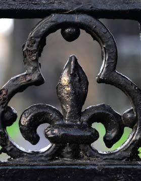
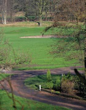
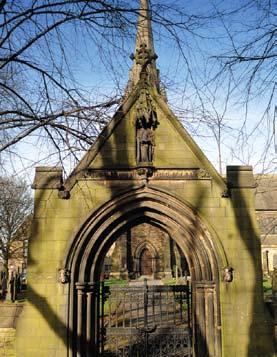
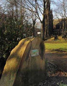
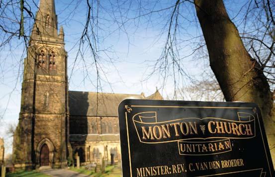
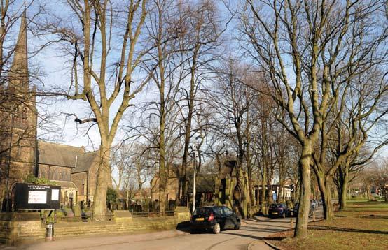
2 To find out more about Salford s heritage, as well as events, trails, what to do and what to see, is the place to go for ideas, information and inspiration. Discover tasty places to eat and drink, investigate Salford s fascinating heritage and explore our marvellous museums and galleries. BARTON ROAD Worsley Green A572 Worsley Woods Broad Oak WORSLEY ROAD Broadoak Park The Trail Monton Green If arriving by car, park at the free car park on Monton Road and walk down towards Monton Green. If arriving by bus (numbers 33 from Manchester and 33 & 22 from Eccles), get off at the Monton Green stop. Your walk begins at Monton Green. You are now standing in the heart of Monton's conservation area which, as well as the green itself, incorporates the Unitarian Church, including a former school with caretaker's house; a lodge built in 1875 to the Earl of Ellesmere's former estate; and a club house with bowling green. Monton Green was part of the estate of the Earl of Ellesmere, but on 8 November 1895 he agreed to make it an open space for public use. And we want you to be a part of it. Send us your pictures, reviews, top tips and comments to info@visitsalford.info and don t forget: check for the very latest news, competitions and updates on everything that s hot in Salford. The Bridgewater Way will enhance and regenerate an important historic canal route for a new role as a safe, accessible connection between the communities along the route. The whole length is 40 miles / 65km, and approximately 4.9 miles / 8km of this will connect communities across the west of Salford such as Barton Aqueduct in Eccles, Liverpool Road, Patricroft and the station, Monton, Worsley and the Delph, and Boothstown Basin. The Bridgewater Canal Trust is currently completing the first stretch of the Bridgewater Way in Salford from Liverpool Road, Eccles to the M602 and this should be open from June Please note that parts of the route may be closed for short periods during construction, and detailed information about footpath closures can be found on the website It is proposed to complete all the works for 2011, the 250th anniversary of the original opening of this historic canal when the Bridgewater Way route will be fully open for all to enjoy. Worsley BARTON ROAD Old Worsley Station Bridgewater Canal VERDUN ROAD Westward Park PARRIN LANE Roe Green Loopline M602 Worsley Golf Course Monton Cromptons Monton Green Monton Church BLACKLEY ROAD Felicinis Walk start/finish Car Park The grade II* listed Unitarian Church was built between 1873 and 1875 and replaced the original Monton Chapel built in Note that the tower and steeple are separate from the main body of the church - this is because they were an afterthought and not part of the original plan. They now house the bell from the original chapel which was retained in memory of the earlier building. The lychgate was erected in 1895 in memory of Henry Leigh. Notice the Institute of Physics blue plaque on the side of the church which reads 'John Henry Poynting FRS Physicist, born in Monton, discovered the Poynting vector and weighed the earth. Attended this church until 1878.' John Henry Poynting was the son of the vicar of the church and was born in a cottage on Monton Road where Prince's apartments now stand. Craters on Mars and the Moon are named after this famous Monton son who was professor of physics at Birmingham University from 1880 to 1914.


3 Railways, coal, physics, lighthouses and barges...


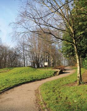
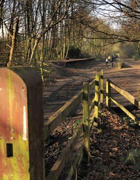
4 In 1848 an infant school attached to the church was opened and the principles on which it was managed led to it taking a high place amongst local educational institutions. The present grade II* listed Memorial Schools were built circa 1864 in memory of Mr and Mrs J Booth and of Silas, Lucy and Esther Leigh who had done so much for the children of the church. In 1864 the London and North Western Railway Company opened a new line from Eccles to Wigan via Tyldesley - today this forms the Tyldsley loopline - and in 1870 a new branch to Bolton via Little Hulton was opened - the Roe Green loopline - along which you are now walking. It was originally only open to colliery traffic, until 1875 when the first passenger services began. Walk past the green with the church on your right and head towards the entrance to the loopline, up the slope directly ahead of you. Continue up onto the main path and continue to follow it. Salford's railway lines are an important reminder of a bygone Victorian age, inextricably linked to the development of the coal mining and railway industries in the region. Today, some of these old railway lines have been converted into public footpaths or 'looplines', providing attractive walkways across the city. Stop at the top of the slope - you are now standing on the site of the old Monton Green station. Monton Green station was opened in November 1887, mainly to cater for suburban commuters into Manchester and was located here alongside the entrance to the Worsley Golf Club. The station was in operation for over 80 years and the last ever train to leave Monton Green left at 10.48am on 5 May 1969 along the Tyldelsey loopline heading for Liverpool. Up until the early 19th century most of the Duke of Bridgewater's coal in Salford was mined and transported by his underground canal system and then distributed by the Bridgewater Canal (more of that later!). However by the mid 19th century new coal mines, including at Brackley, Linneyshaw and Mosely Common, meant that the increase in production could no longer be handled by the canal network. Worsley Station 1913 Continue straight along the loopline until you reach the remains of the old Worsley station. The Farnworth and Worsley Journal of 1874 reported on the opening of this new line: 'To those passengers who have been compelled when visiting Manchester to choose the uninviting route via Moses Gate, or the depressing and cheerless route to Tyldesley, the new line will be a great boon...(it) passes through a district which...abounds in natural beauties, in undulating valleys and clear rippling streamlets, in glorious meadows, rich and green, interspersed with winding roads, protected by hedgerows glistening with hawthorn and looking down upon Nature's carpet of green, amidst the blades of which the cowlip and the primroses love to bloom'. No doubt the landscape has changed somewhat since the 19th century, but there is still much to admire along the route. The Roe Green loopline in particular is today important for its woodlands which are the result of natural seeding and growth following the closure of the line in 1969 and which are now the home to a wide array of wildlife.


5 Take a fresh look at Salford


 Believe it or not you are now standing in the birthplace of the transport revolution in the UK!")

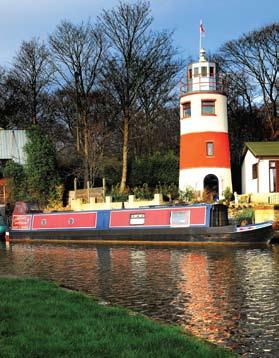
6 Continue just past Worsley Station until you reach Hollyhurst Road leading onto the main Worsley Road. Turn left and follow Worsley Road along towards Worsley village. Continue on until you reach The Green. Turn left here to follow this road alongside Worsley Green on your right until you reach the footbridge over the canal. Worsley Station was built after the demolition of six earlier cottages. Earth excavated from the new line was used to level nearby roads, including the infilling of the very deep hollow at Greenleach Lane known as Fairy Fells. The cutting of the first soil prior to building the station was performed in 1861 by the second Earl of Ellesmere. (The Roe Green loopline does continue from here up through Worsley, Roe Green and all the way to Little Hulton if you wish to continue on a longer walk. Access routes to and from the line can be found at Greenleach Lane, Walkden Road, Bridgewater Road and Prescott Street.) Believe it or not you are now standing in the birthplace of the transport revolution in the UK! The Bridgewater Canal that you are now standing next to was built by three visionary men, Francis Egerton the 3rd Duke of Bridgewater, John Gilbert and James Brindley, to link the coal mines of the area to Manchester city centre. Work began in 1759 and, upon completion, the price of coal was halved overnight, fuelling the industrial revolution and changing British history forever! If you fancy a break in your walk at this point, there are a number of pubs and cafes in Worsley Village where you can stop for refreshments. Turn left after the footbridge and walk alongside the Bridgewater Canal back towards Monton. Continue along the towpath until you return back at Monton. The Bridgewater Canal boasts some impressive statistics: its total length is 40 miles, with the main stretch between Runcorn and Manchester measuring 28.5 miles. Including the bridge you have just crossed, the canal is spanned by an amazing 78 bridges along its length. With the links to the Manchester Ship Canal, The Duke of Bridgewater saw the commercial possibilities of carrying more than coal along the canal and by 1855 approximately two million tons of raw cotton from Liverpool. Other cargo included maize, wheat and rice from Italy and Australia, lead from North America and paraffin from Burma, and, of course, passengers too. The passenger service began in 1769 and by 1781 there were daily sailings to Runcorn. Another service ran between Manchester and Worsley, taking a speedy two and a half hours. The most famous passenger was Queen Victoria, who paid a visit to Worsley in On your return to Monton, look out for the famous local landmark, the lighthouse! A local resident with an eye for the unusual built this 36 foot high folly which catches the eye of passing narrowboat owners and walkers. As Monton is 30 miles from the coast, no ships have ever wandered this far off course so far, but the Monton lighthouse is on hand just in case...


7 If, after your walk, you fancy some refreshments, you could pop into Cromptons at the Waterside on the opposite side of the canal. On a fine day you can sit outside on the waterside terrace and watch the barges pass by. Alternatively walk a few more yards back into Monton village and choose from the Coffee Shop, Felicinis or, in the evening, Blacksticks restaurant. Or if you wish to continue your walk you can follow the route of another of the area's old railway lines - just off Monton Road, before the Monton House Hotel, you will find the entrance to the Monton Walkway which follows the old Patricroft to Molyneaux (later Clifton Junction) line and now takes you as far as the East Lancashire Road in Swinton. If this walk has whetted your appetite to find out more about the local area, log onto to download the Worsley Village Heritage Trail.


8 Designed by AIR Advertising Tel:
THE BRIDGEWATER CANAL IN SALFORD Autumn Activities. september to december 2017
 THE BRIDGEWATER CANAL IN SALFORD Autumn Activities september to december 2017 contents Page 3 Page 4-5 Page 6 Page 7 Bridgewater Nature Bridgewater families Greater Manchester Walking Week Salford Food
Danbury Words and pictures by Laurie Page of the Public Rights of Way team at Essex County Council.
 Danbury Words and pictures by Laurie Page of the Public Rights of Way team at Essex County Council. An undulating walk from Danbury village to the bluebells at the National Trust property of Blakes Wood.
THE BRIDGEWATER CANAL IN SALFORD Autumn Activities
 THE BRIDGEWATER CANAL IN SALFORD Autumn Activities September to december 2015 GREATEST SMARTEST FINEST HAPPIEST PROUDEST BIGGEST BRIGHTEST EST.1761 2 Est.1761 As the turning of the leaves from green to
Route Summary. Distance: 8 miles Approximate Time: 2-3 Hours
 Bridgewater Canal- Worsley to Manchester Easy Trail: Please be aware that the grading of this trail was set according to normal water levels and conditions. Weather and water level/conditions can change
Sandilands to Huttoft Bank
 Coastal Country Park Walks Sandilands to Huttoft Bank A CIRCULAR WALK OF 11KM (7 MILES) INTRODUCTION The Lincolnshire Coastal Country Park lies between Sandilands, Chapel St Leonards and Huttoft on the
The Hundred Parishes
 The Hundred Parishes Walks from railway stations number 9 6.4 miles (10kms) from Bishop s Stortford to Stansted Mountfitchet Start: Bishop s Stortford station (Grid Reference TL492209) (ample parking and
There are toilets at Manningtree Station, Flatford (close to the hump back bridge) and in Dedham.
 and in Dedham.") Arriving by Train Main Features of the Walk Outline Route Employs particularly attractive paths, many of which offer impressive views across Dedham Vale. Includes a section along the tidal section of the
Arriving by Train Main Features of the Walk Outline Route Employs particularly attractive paths, many of which offer impressive views across Dedham Vale. Includes a section along the tidal section of the
9.5 km Circular 3 hours
 RANMORE CIRCULAR A 6 mile (9.5km) circular walk from Boxhill and Westhumble Station in the village of Westhumble, passing through part of the Polesden Lacey Estate, Ranmore Common and Denbies Vineyard.
Walk Description. Directions
 Title: Saffron Trail: Battlesbridge to Chelmsford Distance: 14¾ miles Time taken: 6 hours Start Point: Outside the Barge Inn, Battlesbridge OS Explorer Map: 175 & 183 Grid Ref.: TQ 780 947 Transport: Rail:-
Fertile farms in the heart of Kent
 55 55 Fertile farms in the heart of Kent A bright sunny day is perfect for enjoying the rich and fertile Kent countryside and outstanding views across the valley of the Great Stour to the North Downs.
A Walk around Holmes Chapel starting & finishing at Holmes Chapel Railway Station. by Tony & Lindsay Wright (2016)
") A Walk around Holmes Chapel starting & finishing at Holmes Chapel Railway Station. by Tony & Lindsay Wright (2016) Introduction Holmes Chapel Railway Station is on the Crewe to Manchester line. The station
A Walk around Holmes Chapel starting & finishing at Holmes Chapel Railway Station. by Tony & Lindsay Wright (2016) Introduction Holmes Chapel Railway Station is on the Crewe to Manchester line. The station
connectivity through walking and cycling
 active design case study the national forest: connectivity through walking and cycling active design principles in action: 1. ACTIVITY FOR ALL 2. WALKABLE COMMUNITIES 3. CONNECTED WALKING & CYCLING ROUTES
TOWPATH WALK. Fold out map. inside! Revealing Oldknow s Legacy GUIDE & MAP MARPLE & MELLOR. oldknows.com
 2 TOWPATH WALK Fold out map inside! 3 4 Revealing Oldknow s Legacy GUIDE & MAP & MELLOR oldknows.com and the Peak Forest Canal in Marple SAMUEL OLDKNOW Samuel Oldknow, a Lancashire born muslin manufacturer,
A circular walk of or km (2 1 4 or miles)
") Grantham A circular walk of 3 3 4 or 5 3 4 km (2 1 4 or 3 1 2 miles) Introduction This relatively short circular walk, which starts in the middle of Grantham, offers plenty of variety. The route takes
Grantham A circular walk of 3 3 4 or 5 3 4 km (2 1 4 or 3 1 2 miles) Introduction This relatively short circular walk, which starts in the middle of Grantham, offers plenty of variety. The route takes
Lincolnshire Limewoods Walks. Woodhall Spa. A circular walk of 13km (8 miles)
") Lincolnshire Limewoods Walks Woodhall Spa A circular walk of 13km (8 miles) Introduction The Lincolnshire Limewoods is an area between Wragby, Bardney and Woodhall Spa. It is a fantastic place to explore
Lincolnshire Limewoods Walks Woodhall Spa A circular walk of 13km (8 miles) Introduction The Lincolnshire Limewoods is an area between Wragby, Bardney and Woodhall Spa. It is a fantastic place to explore
Birmingham and return from Worcester
 UK Canal Boating UK Canal Boating Escape with a canal boating holiday! Telephone : 01395 443545 Email : contact@ukcanalboating.com Booking Office : PO Box 57, Budleigh Salterton. Devon. EX9 7ZN. England.
CHILTERN RAMBLING TRAIL
 CHILTERN RAMBLING TRAIL This route, including a section of the Ridgeway Long Distance Path, offers breathtaking views from the Chiltern ridge. It starts in the Ashridge Estate and returns to Tring via
Walk 7: Watchet to washford
 Walk 7: Watchet to washford Length: Moderate - 7.5 miles / 12 km Good For: Theme: History Duration: 2-3 hours depending on speed of walking Notes: This is a moderate to difficult walk in places, with steps,
WALKING GROUP 9 th JANUARY 2013
 WALKING GROUP 9 th JANUARY 2013 For our first walk of 2013 we were fortunate to have a dry, sunny day. Val hand Fred had planned a walk around Stratford on hard footpaths as the fields were still very
Manchester Health Walks Newsletter
 Manchester Health Walks Newsletter Issue 6 July Sept 2011 Welcome! to the Manchester Health Walks Newsletter 6th Issue. This newsletter is put together by the Physical Activity Referral Service (PARS)
The History of Railways into Grimsby
 The History of Railways into Grimsby Grimsby at the beginning of the 19 th C was no more than a small east coast market town with a small dock, which suffered from silting problems. The population was
Walks in Chellow Dene
 City of Bradford Metropolitan District Council Leisure Services a breath of fresh air Walks in Chellow Dene In association with the Fairweather Green and Daisy Hill Action groups Chellow Dene Chellow Dene
Lincolnshire Walks. Grainthorpe. Three circular walks of 2 ¾, 9 and 9 ½ km (1 ¾, 5 ½ and 6 miles)
") Lincolnshire Walks Grainthorpe Three circular walks of ¾, 9 and 9 ½ km (1 ¾, ½ and 6 miles) Introduction Explore the coastal marshes, arable hinterland, Louth Navigation canal and the village of Grainthorpe
Lincolnshire Walks Grainthorpe Three circular walks of ¾, 9 and 9 ½ km (1 ¾, ½ and 6 miles) Introduction Explore the coastal marshes, arable hinterland, Louth Navigation canal and the village of Grainthorpe
Bonnie Prince Charlie Walk
 Bonnie Prince Charlie Walk A waymarked route from Ashbourne to Derby to celebrate the 60th anniversary (1995) of the formation of the Ramblers' Association. This route follows the general direction of
Clyde Walkway Community Links: Nemphlar Moor Road to Braidwood
 Clyde Walkway Community Links: Nemphlar Moor Road to Braidwood Nemphlar Moor Road to Braidwood Digital Trail Difficulty (out of 3) 2 Distance Main route to Braidwood (shortest) 2.5km, 5km return. Detours
Weatherman Walking. Approximate distance: 5.5 miles For this walk we ve included OS grid references should you wish to use them. Start.
 Approximate distance: 5.5 miles For this walk we ve included OS grid references should you wish to use them. 4 1 Start End 3 2 N W E S Reproduced by permission of Ordnance Survey on behalf of HMSO. Crown
Slindon Folly - South Downs, West Sussex
 Slindon Folly - South Downs, West Sussex Starts at Park road-side near entrance to Slindon College 2 hours 15 minutes 4.5miles 7.2km Easy ID: 0.1598 Developed by: Chris Mumford Checked by: Rockpit www.ramblersroutes.org
holly tree Wellhill Farm Woodyard Bramham House red kites Round House ha-ha
 This 6.4 mile walk around the magnificent Bramham Park Estate has been made possible with the active support of the owner of the Estate, Nick Lane Fox, with funding from Natural England, as part of Defra
CHINTHURST HILL AND THE GRANTLEY ARMS, SURREY
 CHINTHURST HILL AND THE GRANTLEY ARMS, SURREY 4 miles Circular 2 hours 110417 Challenging Terrain A 4 mile (can be shortened to 3 miles) circular pub walk near Wonersh in Surrey. The walk begins with an
Gainsborough and Fledborough Circular
 Trent Vale Cycle Route TVCR18 Gainsborough and Fledborough Circular Gainsborough Old Hall. One of the biggest and best preserved Medieval Manor Houses in England. Start Point: Gainsborough Marshall s Yard
Lacock Road Races - 10th June 2018, from 09:00 Lacock Playing Fields, Lacock, SN15 2LG.
 Lacock Road Races - 10th June 2018, from 09:00 Lacock Playing Fields, Lacock, SN15 2LG. Important Notices This is a Closed Roads event. As always, an event never occurs in isolation, and we must work with
For more information and to buy this book click here ISBN: CICERONE. Guides for walkers, trekkers, mountaineers, climbers and cyclists
 For more information and to buy this book click here ISBN: 9781852845377 CICERONE Guides for walkers, trekkers, mountaineers, climbers and cyclists www.cicerone.co.uk WALK 5 Ouston and Urpeth Distance
Countryside Walks. 1) Highclere Park Public Walk.
 Highclere Park Public Walk.") 1) Highclere Park Public Walk. Access: From Highclere Estate Main Entrance at Whitway, please note there is no parking on site or access for vehicles. Open: Throughout the year. Description: This footpath
1) Highclere Park Public Walk. Access: From Highclere Estate Main Entrance at Whitway, please note there is no parking on site or access for vehicles. Open: Throughout the year. Description: This footpath
Hawkesbury Canal Junction. (Sutton Stop) Near Coventry.
 Near Coventry.") Hawkesbury Canal Junction. (Sutton Stop) Near Coventry. Starts at Hawkesbury Canal Junction,Blackhorse Road,Bedworth 1 hours 49 minutes 5.5miles 8.9km Leisurely ID: 0.1798 Developed by: Peter Hopewell
Hawkesbury Canal Junction. (Sutton Stop) Near Coventry. Starts at Hawkesbury Canal Junction,Blackhorse Road,Bedworth 1 hours 49 minutes 5.5miles 8.9km Leisurely ID: 0.1798 Developed by: Peter Hopewell
The North Pennines from near Langwathby
 3.6 Langwathby to Armathwaite Map panel?? Distance 12.7 miles (20.5 km) Terrain farm, woodland and riverside paths; some potentially muddy tracks; a few short sections of road Grade gently undulating Food
Chapel Point to Anderby Creek
 Coastal Country Park Walks Chapel Point to Anderby Creek A CIRCULAR WALK OF 8.5 OR 6 KM (5.3 OR 3.75 MILES) INTRODUCTION The Lincolnshire Coastal Country Park lies between Sandilands, Chapel St Leonards
Cilgerran Wildlife Park Circular Walk
 Walking embrokeshire Cilgerran Wildlife ark Circular Walk It s good to walk, so why not step out and sample some of the walks your neighbourhood has to offer. This pleasant and interesting walk which starts
Lincolnshire Walks. Ancaster. Three cir cular walks of2 3/4,4or 6km (11/3, 21/2 or 33/4 miles)
") Lincolnshire Walks Ancaster Three cir cular walks of2 3/4,4or 6km (11/3, 21/2 or 33/4 miles) Introduction These walks are set in the attractive countryside around the historic town of Ancaster. The town
Lincolnshire Walks Ancaster Three cir cular walks of2 3/4,4or 6km (11/3, 21/2 or 33/4 miles) Introduction These walks are set in the attractive countryside around the historic town of Ancaster. The town
Ovington and Itchen Stoke
 Trail Activity Type Terrain Author Distance Ascent Location : HAMPTR0057 : Walk : Pub : Towpaths and Cycle Tracks : Peter Carne : 1.4 miles / 2.2 kms : 62 feet / 19 metres : SU560318 / SO24 0RE Bush Inn,
A WALK ROUND POYNTON TAKING IN THE AREA S MINING HERITAGE
 A WALK ROUND POYNTON TAKING IN THE AREA S MINING HERITAGE Distance: 6 miles Duration: 2 hrs 45 mins Height Gain: 278 ft Start Grid Ref SJ 92363 83578 (Add between 1-2 hours to the walk if visiting Anson
Approximate distance: 5.5 miles For this walk we ve included OS grid references should you wish to use them. Start. End
 Approximate distance: 5.5 miles For this walk we ve included OS grid references should you wish to use them. End 4 1 Start 3 2 N W E S Reproduced by permission of Ordnance Survey on behalf of HMSO. Crown
Clyde Walkway Community Links: Rosebank Circular via Ashgill and Dalserf
 Clyde Walkway Community Links: Rosebank Circular via Ashgill and Dalserf Rosebank Circular via Ashgill and Dalserf Digital Trail Difficulty (out of 3) 1 Distance 7 km / 4.35 miles. Time 2 hours Terrain
Thornton le Dale Walks
 Thornton le Dale Walks A collection of circular walks in, and around, the village www.visitthorntonledale.co.uk Thornton-le-Dale Traders Forum and Thornton le Dale Parish Council 1 Thornton le Dale Circular
2.4 mile swim 112 mile bike 26.2 mile run
 2.4 mile swim 112 mile bike 26.2 mile run A spectating and info guide for the UK s premier long distance triathlon. This guide will help you get around and watch the IRONMAN UK event, as well as transport
The Pole House Angarrack Hayle
 The Pole House Angarrack Hayle The Pole House 1 Steamers Meadow, Angarrack, Hayle, TR27 5GY Japanese styled Pole House perfect for exploring the beaches of the north coast and west Cornwall Gwithian -
BORSDANE WOOD FROM ASPULL CIVIC HALL. Jubilee Legacy Walks
 HEALTH & WELLBEING (DIAMOND ROUTE) BORSDANE WOOD FROM ASPULL CIVIC HALL Approximate distance:.8 miles / 7.7 km Allow. to hours This walk is one of a series of fifteen Jubilee Legacy Walks designed to celebrate
Greenwood. Walks. Cossall Canal Walk. Cossall Canal Walk
 Cossall Canal Walk C5 Cossall Canal Walk C5 Features: Cossall is a picturesque, relatively unspoiled village on the Nottingham canal, four miles south-east of Eastwood. Architecturally interesting. See
10 km Circular 3 hours
 FRIMLEY AND FRIMLEY GREEN 10 km Circular 3 hours Easy Terrain 250716 A 10km (6 mile) circular walk exploring the canal towpath, riverside path, woodland, heath and small settlements around Frimley in Surrey.
Date: Ground: 45. Match: 12 (69) Venue: The Fortis Stadium. Teams: Wellington Amateurs V Sikh Hunters
 Venue: The Fortis Stadium. Teams: Wellington Amateurs V Sikh Hunters") Date: 29.09.2018 Ground: 45 Match: 12 (69) Venue: The Fortis Stadium Teams: Wellington Amateurs V Sikh Hunters Competition: West Midlands Regional League Division One Admission: 4 Final Score: 0-3 (H/T
Date: 29.09.2018 Ground: 45 Match: 12 (69) Venue: The Fortis Stadium Teams: Wellington Amateurs V Sikh Hunters Competition: West Midlands Regional League Division One Admission: 4 Final Score: 0-3 (H/T
AMAZING WALKS RIGHT ON YOUR DOORSTEP AT WALLOPS WOOD COTTAGES!
 Wallops Wood Cottages Sheardley Lane, Droxford, Hampshire, SO32 3QY emma@wallopswoodcottages.co.uk T: 01489 878888 Sign-up to our NEWSLETTER for special offers and news. You can also follow us on social
F R E E R E s E R v o i R WA L K s REsERvoiR WALKs To BLoW AWAY THE CoBWEBs BRougHT To You BY
 F R E E r e s e r v o i r WALKS reservoir WALKS TO BLOW AWAY THE COBWEBS Brought to you by Only available in Yorkshire. We look after 72,000 acres of land in Yorkshire, spanning the North York Moors, the
For Your Own Safety. Please make a note below of the contact number that should be used in the event that you get lost or require other assistance
 Respect Protect Enjoy Respect other people Consider the local community and other people enjoying the outdoors Leave gates and property as you find them and follow paths unless wider access is available
Lacock Road Races - 18th June 2017, from 09:00 Lacock Playing Fields, Lacock, SN15 2LG.
 Lacock Road Races - 18th June 2017, from 09:00 Lacock Playing Fields, Lacock, SN15 2LG. Important Notices This is a Closed Roads event. As always, an event never occurs in isolation, and we must work with
THE DOG AND DUCK HAREWOODS ESTATE TRAIL. 6 Miles Circular 3 hours. Getting there. Walk Sections
 THE DOG AND DUCK HAREWOODS ESTATE TRAIL Moderate Terrain A 6 mile circular pub walk from the Dog and Duck in Outwood, Surrey. The Dog and Duck is a delightful pub where everyone is made welcome. From walkers
Approximate distance: 10 miles For this walk we ve included OS grid references should you wish to use them. Start. End
 Approximate distance: 10 miles For this walk we ve included OS grid references should you wish to use them. 2 3 Start End 1 N W E S Reproduced by permission of Ordnance Survey on behalf of HMSO. Crown
Walk: NOC 08 Location: Cym Glyn near Brecon
 33 Walk: NOC 08 Location: Cym Glyn near Brecon Directions: Not easy to find at all. Go to Libanus, then head towards Brecon on the A470. Take minor C road single track lane first right as you come out
Waterhead Pier to Orrest Head, Windermere and Bowness
 Waterhead Pier to Orrest Head, Windermere and Bowness A 4 1 2 hour walk through Woodlands and the Troutbeck Valley with spectacular Lake and Mountain views and a lakeshore path. Walk 10 Walk 11 Walk 12
Map and Directions. Walking to raise funds for North London Hospice #bigfunwalk
 Map and Directions Walking to raise funds for North London Hospice 020 8446 2288 www.bigfunwalk.co.uk #bigfunwalk BFW_MAP_2018.indd 1 22/04/2018 21:32 START The Blue Line is the regular route and the Red
Weatherman Walking Sully to Penarth Approximate distance: 5 miles End Start
 Approximate distance: 5 miles For this walk we ve included OS grid references should you wish to use them. 4 End Start 2 3 N W E 1 S Reproduced by permission of Ordnance Survey on behalf of HMSO. Crown
Short and healthy walks AROUND BEDALE. with Hambleton Strollers. North Yorkshire County Council
 Short and healthy walks AROUND BEDALE with Hambleton Strollers North Yorkshire County Council Bedale Strollers Why walk? Being active is good for our physical and mental health. Just 30 minutes of moderate
Maps The maps provided are a guide and are not to scale. Please use OS Explorer Map 120 (Chichester).
.") A Walker s Guide - Chichester Harbour Useful Information Directions All the walks were tested in 2013. Please note, however, that some footpaths may be diverted and buildings such as pubs may have changed
A Walker s Guide - Chichester Harbour Useful Information Directions All the walks were tested in 2013. Please note, however, that some footpaths may be diverted and buildings such as pubs may have changed
9.5 km Circular 3 hours
 MEDIEVAL WAVERLEY Challenging Terrain A 6 mile (9.5km) undulating circular walk from Tilford village passing close to The Sands village and the historic ruins of Waverley Abbey. From the top of Crooksbury
10 Miles Circular 5 hours
 VISIT RYEDALE PICKERING AND CAWTHORN CAMPS 10 Miles Circular 5 hours Moderate Terrain 120616 A 10 mile (16km) there and back walk from the market town of Pickering in Ryedale. The route heads north through
Dorridge & District Residents Association A Walk Along The Green Belt From Dorridge to Catherine-de-Barnes
 Dorridge & District Residents Association A Walk Along The Green Belt From Dorridge to Carine-de-Barnes The starting section of this walk through open fields would be destroyed by building of motorway
Maps The maps provided are a guide and are not to scale. Please use OS Explorer Map 120 (Chichester).
.") A Walker s Guide - Chichester Harbour Useful Information Directions All the walks were tested in 201. Please note, however, that some footpaths may be diverted and buildings such as pubs may have changed
A Walker s Guide - Chichester Harbour Useful Information Directions All the walks were tested in 201. Please note, however, that some footpaths may be diverted and buildings such as pubs may have changed
Thornton le Dale Walks
 Thornton le Dale Walks A collection of walks in and around the village Thornton le Dale Traders Forum www.visitthorntonledale.co.uk Thornton le Dale Walks Walk 1: Beck Isle Cottage and All Saints Church
The Worcestershire Beacon Race Short Walk. The Worcestershire Beacon Race Walk
 The Worcestershire Beacon Race Walk This is an abridged version of walk 5, taken from the Pictorial Guide to the Malvern Hills Book Two: Great Malvern. This walk seeks to avoid where ever possible very
RANS WOOD WALK circa 3 miles/ 5 kilometres
 RANS WOOD EXCURSION This walk is about an hour. It is rarely frequented by tourists or by visitors to the National Park. It is a secret favourite amongst local dog walkers and cyclists. The walk is in
Canals. All About. These notes are designed to help you with homework and other projects. canalriverexplorers.org.uk
 All About Canals These notes are designed to help you with homework and other projects. It will help you to discover: how canals are different from rivers why canals were built who built canals and when
Comments The Plan for Port Whitby
 Comments The Plan for Port Whitby April 24th, 2013 Community Meeting #2 Summary Report Prepared by GLPi April 29th, 2013 1 Introduction The purpose of the Port Whitby Secondary Plan Update, Community Improvement
CUERDEN TRANSPORT PROPOSALS
 1 CUERDEN TRANSPORT PROPOSALS The transport assessment, submitted with the Cuerden development planning application, looks at access to the site and the impact on the local road network in detail. This
BALCOMBE AND ARDINGLY RESERVOIR, WEST SUSSEX
 BALCOMBE AND ARDINGLY RESERVOIR, WEST SUSSEX 7 miles Circular 4 hours 080816 Challenging Terrain Hi, I'm Luke and this is my West Sussex Weekends walk It's a 7 mile loop from Balcombe rail station, taking
BUDE CANAL REGENERATION
 BUDE CANAL REGENERATION Phase II Bude Canal & Harbour Society Registered Charity No.1086646 www.bude-canal.co.uk Figs 1 to 4. The Lower Wharf after completion of Phase I clear evidence of a successful
The Worcestershire Beacon Race Walk. The Worcestershire Beacon Race Walk
 The Worcestershire Beacon Race Walk This is an abridged version of walk 5, taken from the Pictorial Guide to the Malvern Hills Book Two: Great Malvern. Copies are available from the Tourist Information
I #. Short and healthy walks. AROUND Bedale. With Hambleton Strollers
 I #. Short and healthy walks AROUND Bedale With Hambleton Strollers Why walk? Being active is good for our physical and mental health. Just 30 minutes of moderate activity, such as brisk walking, 5 times
& r al. Two circular walks of 8 km (5 miles) wal k
 wal k") & Ru r al Two circular walks of 8 km (5 miles) s ford Riv m a t S er wal k Introduction Stamford is noted as being one of the finest stone towns in the country. The stone being local limestone and Collyweston
& Ru r al Two circular walks of 8 km (5 miles) s ford Riv m a t S er wal k Introduction Stamford is noted as being one of the finest stone towns in the country. The stone being local limestone and Collyweston
Walking London: Thirty Original Walks In And Around London By Andrew Duncan
 Walking London: Thirty Original Walks In And Around London By Andrew Duncan If you are searched for a ebook by Andrew Duncan Walking London: Thirty Original Walks In and Around London in pdf format, then
GROUP PRE-VISIT GUIDE
 GROUP PRE-VISIT GUIDE Helpful Reminders LUNCH If your group is bringing bagged lunches Reservations in the School Lunchroom are required ($15 flat fee) if your group is bringing bagged lunches. Please
Angel Drove carpark 3/day
 GETTING TO ELY ( A on the map below marks the city centre; for a larger scale see the map at the end of the directions, where there are also details of car parking and pedestrian access to the venue) Angel
Launton to Bicester nature footpath improved
 Launton to Bicester nature footpath improved Published 13 July 2012 An attractive rural footpath linking Launton to Bicester has brought back into use by the council's Countryside team. Staff have improved
Beautiful Walks from the Blue Ball Inn
 Walk No. 7 COAST AND VALLEY WALK Countisbury, Glenthorne, County Gate, Brendon, Rockford and Wilsham 10 MILES APPROX. Walking time 5 hours approx. (not including breaks)> OS Sheet 64/74 Lynton and Lynmouth.
2-3 miles - up to 90 minutes walks
 SHIREHAMPTON COMMUNITY ACTION FORUM Walkie-Talkies Issue 17 Free Walks Programme From January 2017, due to changes in the way that LinkAge operates, there will no longer be a Health Walks Coordinator in
HERITAGE, LEGEND and NATURE in the VALLEYS WALK ND6 SARN HELEN, ST PATRICK & HENRHYD FALLS The Romans, Saint Patrick and a Waterfall
 HERITAGE, LEGEND and NATURE in the VALLEYS WALK ND6 SARN HELEN, ST PATRICK & HENRHYD FALLS The Romans, Saint Patrick and a Waterfall Historic & Geographic Background Banwen is best known as a former mining
Saltash, Cornwall - Railways, Rivers & Castles
 Saltash, Cornwall - Railways, Rivers & Castles Starts at St Stephen's Church, Saltash, Cornwall 2 hours 45 minutes 5.5miles 8.9km Easy ID: 0.2532 Developed by: Peter Clements Checked by: Kevin Connor www.ramblersroutes.org
The Griffon Guide The North Walsham and Dilham Canal Trail
 The Griffon Guide The North Walsham and Dilham Canal Trail This trail explores some of the most accessible and interesting parts of the North Walsham and Dilham Canal. The canal was built in 1825 to allow
ST. AGNES. you cannot put a time limit on beauty.
 ST. AGNES CIRCULAR WALKS AROUND There are many enjoyable and picturesque walks around St. Agnes most are signposted and are featured on the St. Agnes Mini-guide map. Because most of our footpaths are in
The Foreshore Walk. 24m. 1m Lake Macquarie LGA. 1 hr 15 mins 2.9 km One way. Hard track 81m
 The Foreshore Walk 1 hr 15 mins 2.9 km One way Hard track 81m This walk traverses the coastline of the Green Point reserve. By following a variety of tracks and occasionally traveling inland through eucalyptus
No. 1 By River Ribble & Brungerley Park 3¼ Miles,
 RVRNEWS 102 No. 1 By River Ribble & Brungerley Park 3¼ Miles, Approx 2 Hours This walk starts at the gate on platform 2 of Clitheroe station. Leaving the station turn left making towards Kirkmoor Rd and
SIX WALKS FROM SHRIGLEY HALL HOTEL COLLECT A COPY FROM HOTEL RECEPTION (PLEASE NOTE, WALKING AROUND OR ACROSS THE GOLF COURSE IS NOT PERMITTED)
") SIX WALKS FROM SHRIGLEY HALL HOTEL COLLECT A COPY FROM HOTEL RECEPTION (PLEASE NOTE, WALKING AROUND OR ACROSS THE GOLF COURSE IS NOT PERMITTED) SH WALK 1 - SHRIGLEY HALL THE NAB LENTH: 2.5 MILES. GRADIENT:
SIX WALKS FROM SHRIGLEY HALL HOTEL COLLECT A COPY FROM HOTEL RECEPTION (PLEASE NOTE, WALKING AROUND OR ACROSS THE GOLF COURSE IS NOT PERMITTED) SH WALK 1 - SHRIGLEY HALL THE NAB LENTH: 2.5 MILES. GRADIENT:
Your views are important. Please fill in a form before you leave. Or alternatively
 Drum Property Group is delighted to welcome you to this exhibition which sets out our initial proposals for a mixed-use development at Stead s Place, Edinburgh. We are keen to hear the views of local people
Forest of Bowland, Lancashire
 Forest of Bowland, Lancashire Starts at Dunsop Bridge (SD660501) 6 hours 0 minutes 13.3miles 21.5km Strenuous ID: 241.4 Developed by: Mark Rowe Checked by: Robin Segulem www.walkmag.co.uk Circular walk
WALK 1 - SHRIGLEY HALL THE NAB LENGTH: 2.5 MILES. GRADIENT: CHALLENGING. STOUT FOOTWEAR REQUIRED
 SIX WALKS FROM SHRIGLEY HALL HOTEL COLLECT A COPY FROM HOTEL RECEPTION 1 (PLEASE NOTE, WALKING AROUND OR ACROSS THE GOLF COURSE IS NOT PERMITTED) WALK 1 - SHRIGLEY HALL THE NAB LENGTH: 2.5 MILES. GRADIENT:
Welsh Newton and Woodland
 Welsh Newton and Woodland This is a 8.2km miles (approx) walk which will take about 2.5 hours at a relaxed and leisurely pace. There are a few hills but no steep inclines. Start at Llangrove bus stop and
This walk description is from happyhiker.co.uk
 This walk description is from happyhiker.co.uk Pendle Hill Walk From Barley Starting point and OS Grid reference Ordnance Survey map Distance Traffic light rating Barley village honesty box car park OS
WALK WELL IN TAUNTON AND WELLINGTON WINTER 2017/18
 WALK WELL IN TAUNTON AND WELLINGTON WINTER 2017/18 www.walkwellwithtone.btck.co.uk Walk Well Taunton Deane WHAT IS A HEALTH WALK? It s a brisk walk done on a regular basis for well-being. It can help you
How to get there. Respect - Protect - Enjoy
 How to get there Driving: Postcode is RG9 3DG and there is a carpark just across from the pub. Nearest station: Henley-on-Thames station is 5.6 miles away. We re delighted to present three circular walks
NEWLANDS CORNER AND ST MARTHAS
 NEWLANDS CORNER AND ST MARTHAS 10k CIRCULAR ROUTE 2½-3HRS GU4 8SE From Newlands Corner on the North Downs just outside Guildford, you can enjoy one of the most beautiful panoramas of quintessential English
Follow the Lantern Way clockwise from Dursley Town Hall through Cam & Coaley to Uley and back to Dursley (about 14 miles)
") According to the Rev Kilvert's diary of 1873, couples on their way to evening services in winter followed a practical though unusual local tradition: "My Mother says that at Dursley, when ladies and gentlemen
According to the Rev Kilvert's diary of 1873, couples on their way to evening services in winter followed a practical though unusual local tradition: "My Mother says that at Dursley, when ladies and gentlemen
Title. Distance Place OS Map. 1-4 Miles Nr. Bakewell Buxton &
 Title. Distance Place OS Map OS 119 Monsal Trail 1-4 Miles Nr. Bakewell Buxton & From Bakewell, Hassop 1 6 Km. Matlock The Monsal Trail is a traffic free route for walkers, cyclists, horse riders and wheelchair
To Happy Valley and Farthing Downs
 1 To Happy Valley and Farthing Downs Woldingham Station - Marden Park - Willey Park - Chaldon Church - Farthing Downs - Coulsdon South/Town Station Length: 10 ½ miles (16.8km) Underfoot: Mainly quiet roads