Charles River Pathways
|
|
|
- Wesley Pierce
- 6 years ago
- Views:
Transcription

1 Charles River Pathways Dr. Paul Dudley White Bike Path Museum of Science to Watertown Square Analysis of the South Shore with conceptual design Proposal Charles River Conservancy August 2006 Prepared by Ofri Gilan
2 1
3 The mission of the Charles River Conservancy is to make the parklands more active, attractive and accessible for all. Improving the 17 miles of pathways along the shoreline will make it safer and easier, thus encouraging increased use for commuting and recreation. This report gives an overview of the current state of the southern shore, lists recommendations, shows examples from elsewhere and illustrates potential underpasses. 2
4 Section Analysis Overview Section A- Galen St. bridge to Nth Beacon St. bridge Section B- Nth. Beacon St. bridge to Arsenal St. bridge Section C- Arsenal St. bridge to Eliot bridge Section D- Eliot bridge to Weeks footbridge Section E- Western Ave bridge to River St. bridge Section F- River St. bridge to BU bridge Section G- BU bridge to Harvard bridge Section H- Harvard bridge to Longfellow bridge Section I- Longfellow bridge to Craigie bridge 3

5 GALEN ST. BRIDGE SECTION A Good Fair Poor 4
6 SEC SECTION D SECTION B SECTION C ELIOT BRIDGE ANDERSON BRIDGE WESTERN AVENUE BRI SECT NTH BEACON ST. ARSENAL BRIDGE RIVER ST. 5

7 CRAIGIE BRIDGE SECTION I DGE ION E SECTION H LONGFELLOW BRIDGE TION F SECTION G HARVARD BRIDGE BU BRIDGE 6

8 Section A Galen St. Bridge to North Beacon St. Bridge GALEN ST. BRIDGE NTH BEACON ST. 7


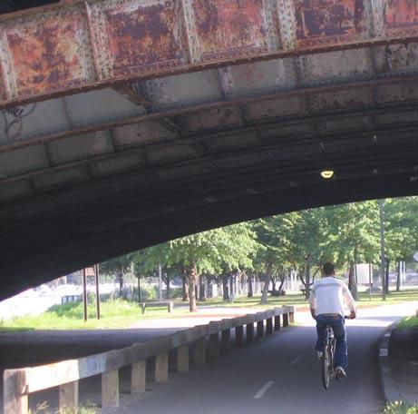
9 Narrow path immediately adjacent to the road Dangerous Intersection: Blindspot due to height of vegetation and angle of intersection; No pedestrian traffic light : Avenue of root heaves Alternative route created by cyclist providing a safer option to the paved path 8

10 Masterplan P.160 (1 of 2) Goals Improve pedestrian safety and experience along Nonantum Road. Open views to the river. Increase the riverbank width where possible. Recommendations Relocate Nonantum Road to the south to create more open space next to the river if the MBTA bus yard at Galen Street becomes available. Eliminate one eastbound lane of Nonantum Road between Galen Street and Charlesbank Road. Widen the pathway to a ten-foot multiuse path. Provide a six- to eight-foot planting strip with a continuous row of street trees to protect and separate the path from the parkway. Eliminate guardrails made obsolete by this additional setback from the embankment. Where guardrails are necessary, use the recommended MDC standard to blend well with the landscape. Establish a new pedestrian bridge in the vicinity of Maple Street or at the bend in the river where long views are afforded in two directions. This new bridge would shorten the walking loops in the Upper Basin and mark the transition from the open boat basin to the narrow river channel at Watertown Square. The bridge design must reflect the special character of the Charles River Basin. Add a pedestrian phase to the existing signal at Galen Street and place a pedestrian crosswalk across Nonantum Road. Establish and maintain scenic vistas at bends in the Charles to capture long views up and down the river. Develop a memorandum of understanding with abutters including the Massachusetts Turnpike Authority, the Perkins School for the Blind, and the Arsenal development group that supports maintenance of the wooded banks on the landside of the parkways that give the Upper Basin its rural feel. Master plan p.158 (2 of 3) Goals Establish safe pedestrian connections to the Basin, along the shore, and between Squibnocket Park, the Watertown Front, and Daly Field. Recommendations Install new pedestrian signals at Charlesbank Road and at the east side of the intersection of Nonantum Road and North Beacon Street. Add a pedestrian phase to the existing traffic signal on the west side of that intersection. Add a crosswalk across Nonantum Road in front of the Newton Yacht Club and align the crosswalk, signal, and handicapped ramp at the intersection of Nonantum Road and Brooks Street. Set the paved pathway further back from Nonantum Road to provide a more suitable environment for parkway trees and to protect people on the path more fully from traffic. Replace the missing oaks next to the path and establish a second row further back from the roadway to define the pathway. Establish a soft path set back from the water s edge for walkers and joggers with clear views of the river. Ensure a public right-of way in front of any future boating facilities. 9


11 Hazards on bike path along Nonantum Rd. Hazards on bike path along Nonantum Rd. 10

12 ARSENAL BRIDGE Section B North Beacon St. Bridge to Arsenal St. Bridge NTH BEACON ST. 11


13 Surface has much root damage and vegetation intrudes into path. Dangerous Intersection: Blindspot due to height of vegetation and angle of intersection; No pedestrian traffic light; ramp is broken Arsenal St. Blind spot when approaching the bridge 12

14 Section C Arsenal St. Bridge to Eliot Bridge ELIOT BRIDGE ARSENAL BRIDGE 13


15 Sink hole, opposite Northeastern University boat house Board walk bridge near Publick Theatre is slippery when wet. Transition from the asphalt is rough Surface humps along this section of the path. Parking lot is used to store dumpsters, hay bales and composing materials, blocking the path entrance. 14

16 Alternative Solutions Picture courtesy Christopher Porter Tunnel under the Boston end of the Eliot Bridge, looking upriver toward Christian Herter Park Since the tunnel does not drain, a raised deck would help, particularly the in-lie skaters and the pedestrians to use underpass even after rain. 15

17 opening the side of the tunnel will increase light exposure and improve its drainage capabilities Eliot Bridge - proposal 16


18 Examples Bicycle Underpasses Melbourne, Australia Melbourne, Australia This example shows how to make a new pedestrian/ cyclists underpass underneath an old bridge structure and along the water s edge 17


19 Pathway along the water s edge has arches open to the water, allowing natural light to reflect off the water and increase visibility and thus security Providence, RI. 18

20 Section D Eliot Bridge to Weeks Footbridge ELIOT BRIDGE ANDERSON BRIDGE 19


21 Weeks pedestrian bridge could be improved by building a ramp to allow wheels use. Little ramp strips to allow bike access. On the way up to Anderson bridge, path narrows and it is blocked by a pole. The path could potential be tucked under the bridge Anderson Bridge, narrow path and tight curve The view to the river is blocked by the high vegetation 20
.")
22 Section E Western Avenue Bridge to River St. Bridge The River St./ Soldier Field Road intersection lacks any safe pedestrian crossings in any direction. Though there are crosswalks, there are no pedestrian signals nor any pedestrian signal phases (designated, safe times to cross the road). The vintage traffic signals have no walk signal of any sort. All intersections involve sharing the right of way. What is needed here is a sharing of the road that gives a fair shake to pedestrians and cyclists, in-line skaters, and joggers. With the expected increase in pedestrian use (due to the Harvard/ Allston development project), this intersection poses as a serious liability for the Department of Conservation and Recreation (DCR). Of particular concern is the crossing at the River Street Bridge. As the weakest link in the Dudley White Pathway, it is affecting the strength of the path as a whole. (River St. report) WESTERN AVENUE BRIDGE RIVER STREET BRIDGE 21


23 River St. bridge zebra crossing is not aligned with the ramp; no pedestrian crossing light. Corner stone is broken; lack of ramp Very narrow path Blind spot at River St. bridge Vegetation is blocking the view to the water 22

24 Proposed underpass at Western Avenue An underpass will assist cyclists to avoid dangerous intersection. 23


25 Examples from Melbourne, Australia Bicycle path is tucked between the freeway and the river-bank. 24

26 Section F River St. Bridge to BU Bridge RIVER STREET BRIDGE BU BRIDGE 25


27 Great underpass Pedestrian crossing should accommodate ramp for wheel access When approaching the BU bridge from Cambridge. The path is accessible only by riding along commonwealth Avenue and re-crossing Storrow Drive at the overpass without a bike ramp. BU BRIDGE Very narrow path, very close to the road 26
28 p. 118 Master plan Improve the continuity and safety of movement along and across the river. Use the abandoned half of the Grand Junction Railroad Bridge to provide pedestrian and bicycle access between the north and south banks of the reservation. A multiuse path for foot and wheeled traffic would occupy the unused side of the bridge bed, and the active rail line would be securely separated from this pathway. Build an earthen embankment ramping up to the railroad bridge from the upstream approach on the south side. If the roadbed can not be used, cantilever the pathway off the railroad bridge on the upstream side. Establish connections in four directions.on the north bank Goals Provide a better buffer between traffic and pedestrians. Widen the path approach to the River Street Bridge by means of a cantilevered structure, if necessary, and provide smooth continuous pavement. Masterplan p.123 In the event that active use of the rail lines is discontinued, connect Boston University s athletic fields and the Beacon rail yards directly to the Basin. Future development of the parcel fronting the approach to the Boston University Bridge also would provide an excellent opportunity for a direct connection to the river. Future rebuilding of the Boston University Bridge should provide pedestrian overlooks to take full advantage of the views up and down the river. 27

29 Existing condition of River St. Level crossing Proposal for River St. underpass 28

30 Section G BU Bridge to Harvard Bridge HARVARD BRIDGE BU BRIDGE 29


31 Great pathway with an alternative path for wheel free use Perfect ramp connection to Harvard bridge from bike path Perfect underpass under Harvard bridge This ramp connects the bike path and Back Bay 30

32 Section H Harvard Bridge to Longfellow Bridge LONGFELLOW BRIDGE HARVARD BRIDGE 31


33 Great overpass. It is difficult to find the way to this overpass and the river from Back Bay Sign honors initiator of bike path Pleasant ride Great pathway 32

34 Section I Longfellow Bridge to Craigie Bridge CRAIGIE BRIDGE LONGFELLOW BRIDGE 33


35 Nice shoreline ride Narrow path adjacent to the road Proximity to a busy road makes the ride unpleasant. Explore pathway along water edge 34
36 Priorities Top priority Second top priority Intersections River St Galen St. Western Avenue North Beacon St. Arsenal St. Anderson Craigie Connections BU bridge Longfellow bridge Craigie bridge Galen St. bridge North Beacon St. bridge Arsenal St. bridge Anderson bridge Weeks footbridge Western Ave. bridge River St. bridge Pathway surface Section A Section B Section F (parts) Section E Section F Section I (near Craigie) To learn more about the Charles River Conservancy s work or to add input to this effort visit their website: 35
37 Credits Thank you for your help: Chris Porter- Charles River Path Report MassBike John Allen- Pathway pictures Kol Peterson ( River Street report, on CRC website) CRC volunteers MDC masterplan ( on CRC website) Peter Munkenbeck- General advice Andrew Brophy- Melbourne pictures 36 35
Bicycle + Pedestrian Connectivity Gap Analysis
 Accelerated Bridge Program Bicycle + Pedestrian Connectivity Gap Analysis Tuesday, October 11 Shriners Hospital, Boston 6:30-8:00 PM Thursday, October 13 Community Rowing, Brighton 6:30-8:00 PM Tuesday,
section 4 Existing Conditions, Issues, and Options
 section 4 Existing Conditions, Issues, and Options 4.0 Existing Conditions, Issues, and Options This section analyzes each segment of the corridor on a street to street basis. Each segment is discussed
Charlesgate. World Series Path
 Tonight s 8 Greenway Designs Commonwealth Ave. Route 9 Crossing Charlesgate Dartmouth St. World Series Path Summer St / L St Arborway 2008 Charlesgate Connection Northeastern University s Civil Engineering
Watertown Complete Streets Prioritization Plan. Public Meeting #1 December 14, 2017
 Watertown Complete Streets Prioritization Plan Public Meeting #1 December 14, 2017 Goals for Public Meeting Overview of MassDOT Complete Streets Funding Program Educate the community on Complete Streets
01. VICINITY OF GREENBRAE POC: EXISTING CONDITIONS
 01. VICINITY OF GREENBRAE POC: EXISTING CONDITIONS Existing Bus Stop Existing US101 On-ramp Existing POC Old Redwood Highway Rich Street City ROW Environmental Study Limit Industrial Way NO DESIGNATED
July 13, Commissioner Richard Sullivan Department of Conservation and Recreation 251 Causeway Street Boston, MA RE: EOEA ENF 13777
 July 13, 2007 Commissioner Richard Sullivan Department of Conservation and Recreation 251 Causeway Street Boston, MA 02110-1301 RE: EOEA ENF 13777 Dear Commissioner Sullivan: WalkBoston has been a steady
FOCUS AREA 1 - Alberta Avenue Pocket Park 3 (121 Ave and 92 St)
") FOCUS AREA 1 - Alberta Avenue Pocket Park 3 (121 Ave and 92 St) New benches Plant evergreen trees Widen existing sidewalk from 1.5m to 1.8m Marked crosswalk 1.8m wide sidewalk Add pedestrian oriented lights
FOCUS AREA 1 - Alberta Avenue Pocket Park 3 (121 Ave and 92 St) New benches Plant evergreen trees Widen existing sidewalk from 1.5m to 1.8m Marked crosswalk 1.8m wide sidewalk Add pedestrian oriented lights
What Is a Complete Street?
 Session 5 Charleen Zimmer, AICP, Zan Associates May 5-7, 2010 What Is a Complete Street? May 2010 5-1 Not a Complete Street More of a Complete Street May 2010 5-2 Benefits of Complete Streets Safety for
Alewife Bicycle and Pedestrian Access Study
 Alewife Bicycle and Pedestrian Access Study July 2009 Final Report 1. Study Purpose The Alewife Access Study has been commissioned to provide recommendations for improving pedestrian and bicycle access
Chapter 7 Nonmotorized Facilities
 Chapter 7 Nonmotorized Facilities What is in this chapter? This chapter discusses existing and proposed pedestrian and bicycle facilities referred to as nonmotorized facilities along the SR 520 corridor.
Memo. Ocean Avenue Corridor Design Project Public Workshop #2 Summary
 Ocean Avenue Corridor Design Project Public Workshop #2 Summary The second public workshop for the Ocean Avenue Corridor Design Project was held on Wednesday, May 14, 2014 from, 6 to 8 pm at Lick Wilmerding
Swamp Road Residents Study
 Swamp Road Residents Study SRRG Meeting with PennDot and Elected Officials Newtown and Wrightstown, PA April 25, 2008 Newtown Township Section of Swamp Road Limited Public Funds No reconstruction of a
Duwamish Way-finding and CTR Report
 V. North Tukwila When the North Tukwila Manufacturing and Industrial Center was designated in 1992 as part of the region s land use and transportation plan, the plan called for the area to set a light-rail
El Camino Real Specific Plan. TAC/CAC Meeting #2 Aug 1, 2018
 El Camino Real Specific Plan TAC/CAC Meeting #2 Aug 1, 2018 Land Use Alternatives Goals and Tradeoffs Parks & open space Housing Retail & services Civic spaces Parking Community gathering spaces 3 Alternatives
2.0 Existing Conditions
 20 2.0 Existing Conditions 2.1 Land Use, Future Growth Patterns, Physical Barriers Geographic Overview Sutter County s land use pattern is characterized by extensive agricultural areas, significant natural
Ballston Station Multimodal Study WMATA and Arlington County. Meeting Minutes
 Date of Meeting: June 10, 2010 Location: Ballston Metrorail Station and NRECA Building 4301 Wilson Blvd, Arlington, VA Subject: Ballston Station Multimodal Study Stakeholder Meeting #1 Summary: This first
INDEX. Geometric Design Guide for Canadian Roads INDEX
 Acceleration lane, see Lanes, Acceleration Access, 8.1 Access Management and Functional Classification 8.2 Access Management by Design Classification 8.3 Access Configuration 8.4 Building Set-Back Guidelines
Complete Streets. Designing Streets for Everyone. Sarnia
 Complete Streets Designing Streets for Everyone Sarnia Complete Streets ~ Sarnia ~ 2018 Introduction Our City is made up of a network of streets that we use to go for a walk, cycle to work, drive to the
I-90 ALLSTON INTERCHANGE A MULTIMODAL TRANSPORTATION PROJECT MEPA CONSULTATION MEETING NOVEMBER 20, 2014 BRIGHTON HIGH SCHOOL
 I-90 ALLSTON INTERCHANGE A MULTIMODAL TRANSPORTATION PROJECT MEPA CONSULTATION MEETING NOVEMBER 20, 2014 BRIGHTON HIGH SCHOOL Today s Agenda 1. 2. 3. 4. 5. Overview of the MEPA Process Project Overview
COWETA HIGH SCHOOL AND EAST HIGHWAY 51
 COWETA HIGH SCHOOL AND EAST HIGHWAY 51 Lack of sidewalks along Ben Lumpkin Rd. Lack of crosswalks and ramps at intersection. Hwy 51 is wide to cross as a pedestrian. No ADA compliance or connection to
Poor pavement condition Substandard Intersections. / Substandard bike/pedestrian/transit accommodations. Driveway access Environmental concerns
 Public Informational Meeting University Avenue (Allen Boulevard Segoe Road) March 23, 2011 City of Madison City of Middleton Village of Shorewood Hills Dane County Existing Roadway Conditions Poor pavement
Henderson Ave. Complete Streets Project
 Henderson Ave. Complete Streets Project Meeting Purpose To finalize conceptual components of project prior to proceeding with preliminary engineering www.dallascompletestreets.wordpress.com MeetingAgenda
Chapter 3 DESIGN SPECIFICATIONS
 Brampton PathWays Planning and Design Guidelines 27 Chapter 3 DESIGN SPECIFICATIONS 3.1 CLASS 1 MULTI-USE PATH Off-road multi-use trails are the backbone of the Brampton PathWays Network. They are typically
Table 1.0 Grade Crossing Enhancements PVL San Jacinto Branch Line
 Grade Crossing Enhancements CPUC 1 2 3 4 5 Citrus Avenue, Riverside County Palmyrita Ave., Columbia Avenue, Marlborough Ave., Spruce St., MP 0.57 002X-0.6 027301Y MP 1.00 002X-1.0 027302F MP 1.24 002X-1.3
Shared Use Path Design
 12B-2 Design Manual Chapter 12 - Sidewalks and Bicycle Facilities 12B - Bicycle Facilities Shared Use Path Design A. Accessible Shared Use Path Design 1. General: Applicable portions from the following
Houma-Thibodaux Metropolitan Planning Organization STP<200K Funding Application APPLICATION
 APPLICATION HOUMA-THIBODAUX METROPOLITAN PLANNING ORGANIZATION (HTMPO) FOR SURFACE TRANSPORTATION PROGRAM (STP
Transportation Corridor Studies: Summary of Recommendations
 Transportation Corridor Studies: Summary of Recommendations Route 4 Corridor Study: Route 10 Corridor Study: Route 44 Corridor Study: Route 175 Corridor Study: Route 5/15 Corridor Study: Rentschler Field
Appendix C. TRAFFIC CALMING PROGRAM TOOLBOX
 Appendix C. TRAFFIC CALMING PROGRAM TOOLBOX PHASE I...2 Do Not Enter Sign...3 One-Way Sign...4 Turn Prohibition...5 Pavement Markings...6 Speed Monitoring Trailer...7 Neighborhood Speed Watch...8 Police
Speed Control & Limits
 Speed Control & Limits Exceeding the speed limit is a common contributing factor of fatal and other types of accidents. *25 mph* School zones, business or residential districts *55 mph* Certain state highways
Somerville Community Path Feasibility Study
 Somerville Community Path Feasibility Study Prepared for: City of Somerville, Massachusetts Strategic Planning and Community Development July 14, 2006 Prepared by: VOLLMER Table of Contents Section 1.0
Public Works Committee Meeting Richard E. Mastrangelo Council Chamber November 20, 2017
 Public Works Committee Meeting Richard E. Mastrangelo Council Chamber November 20, 2017 Purpose of Meeting Why are we here? Project Recap/Updates Project Limits/Segments Road Diet Concept Lessons Learned
Saskatchewan Drive Roadway Rehabilitation and Shared-Use Path Widening
 Saskatchewan Drive Roadway Rehabilitation and Shared-Use Path Widening We are here today to present the draft plan for the Saskatchewan Drive Roadway Rehabilitation and Shared-Use Path Widening project
Thoreau Path Master Plan Final Draft. prepared for: The Boston Redevelopment Authority West End Community November 2007
 Thoreau Path Master Plan Final Draft prepared for: The Boston Redevelopment Authority West End Community November 2007 Introduction Carol R. Johnson Associates ( CRJA ) was retained by the Boston Redevelopment
Off-Road Facilities Part 1: Shared Use Path Design
 Off-Road Facilities Part 1: Shared Use Path Design Presentation by: Eric Mongelli, P.E. Tom Huber October 9, 2012 FOLLOW THE CONVERSATION ON TWITTER Toole Design Group is live tweeting this webinar @tooledesign
11/28/2016 VIA
 11/28/2016 VIA EMAIL Ethan Meltzer, Assistant Planner City of Sacramento Community Development Department 300 Richards Blvd., 3 rd Floor Sacramento, Ca 95811 RE: Natomas Corporate Center Commercial Building
5. RUNNINGWAY GUIDELINES
 5. RUNNINGWAY GUIDELINES These guidelines should be considered collectively when making runningway decisions. A runningway is the linear component of the transit system that forms the right-of-way reserved
5 CIRCULATION AND STREET DESIGN
 5 CIRCULATION AND STREET DESIGN This chapter describes circulation and streetscape improvements proposed for the Northwest Chico Specific Plan Area. It includes detailed design specifications for existing
City of Davis East Covell Corridor Plan
 Community Open House #2 January 22, 2014 6:00 8:00 p.m. Veterans Memorial Center, Club Room City of Davis Introduction The (ECCP) is a taking a comprehensive look at the existing transportation systems
Guidance. ATTACHMENT F: Draft Additional Pages for Bicycle Facility Design Toolkit Separated Bike Lanes: Two-Way to One-Way Transitions
 ATTACHMENT F: Draft Additional Pages for Bicycle Facility Design Toolkit Separated Bike Lanes: Two-Way to One-Way Transitions This treatment provides a transition from two-way separated bike lanes to one-way
100 Cambridge Street, Suite 900 Boston, MA Boston, MA 02114
 March 28, 2008 Secretary Ian A. Bowles Jay Rourke Executive Office of Environmental Affairs Boston Redevelopment Authority Attn: Holly Johnson One City Hall Square 100 Cambridge Street, Suite 900 Boston,
Figure 4-10: Pedestrian Improvements Types of Potential Station Area Improvements - Place-Making Improvements
 INCORPORATE FEATURE PAVIN IN CROSSWALK AND INTERSECTION FIELDS Identifies high-priority pedestrian areas and create a station identity through colorful and interesting patterns ADD CURB EXTENSIONS Extending
6.4 RECOMMENDED IMPROVEMENTS
 6.4 RECOMMENDED IMPROVEMENTS 6.4.1 Williston Road Recommendations While all alternatives would be an improvement over existing conditions, Alternative 3B is recommended over the others because it provides
Figure 3B-1. Examples of Two-Lane, Two-Way Marking Applications
 Figure 3B-1. Examples of Two-Lane, Two-Way Marking Applications A - Typical two-lane, two-way marking with passing permitted in both directions B - Typical two-lane, two-way marking with no-passing zones
CHECKLIST 2: PRELIMINARY DESIGN STAGE AUDIT
 CHECKLIST 2: PRELIMINARY DESIGN STAGE AUDIT 2.1 General topics 2.1.1 Changes since previous audit Do the conditions for which the scheme was originally designed still apply? (for example, no changes to
US 278 Corridor Concept Presentation. Avondale Estates Intersection Improvement/Roundabout and Road Diet Feasibility Study March 19, 2015
 US 278 Corridor Concept Presentation Avondale Estates Intersection Improvement/Roundabout and Road Diet Feasibility Study March 19, 2015 Thanks to our Partners Atlanta Regional Commission Georgia Department
MAG Town of Cave Creek Bike Study Task 6 Executive Summary and Regional Significance Report
 Page 1 MAG Town of Cave Creek Bike Study Task 6 Executive Summary and Regional Significance Report August 1, 2012 MAG Project #481 Page 2 Task 6 Executive Summary and Regional Significance Report Introduction
Typical Cross Section: DOWNTOWN (Observer Highway - 8th Street)
") Typical Cross Section: DOWNTOWN (Observer Highway - 8th Street) DRAFT SEPTEMBER 23, 14 1 Washington Street Typical Block Downtown Typical Block: DOWNTOWN (Observer Highway - 8th Street) New crosswalks
Typical Cross Section: DOWNTOWN (Observer Highway - 8th Street) DRAFT SEPTEMBER 23, 14 1 Washington Street Typical Block Downtown Typical Block: DOWNTOWN (Observer Highway - 8th Street) New crosswalks
Blair/Williamson Intersection Expressed Needs
 Blair/Williamson Intersection Expressed Needs NORTH Blair Street is a barrier for pedestrians and bicycles Relocate Capitol City Trail crossing from Blair Street and John Nolen Drive intersection to Williamson
May 4, Dear Mr. Thomas and Mr. Snyder,
 Daniel Thomas, Principal Planner Christopher Snyder, County Engineer DuPage County Division of Transportation 421 N County Farm Road Wheaton, IL 60187 May 4, 2016 Dear Mr. Thomas and Mr. Snyder, On behalf
Table of Contents. Introduction. Prompt List Arterials and Streets. Prompt List Interchange. Prompt List Intersections. Prompt List Limited Access
 Table of Contents Introduction Prompt List Arterials and Streets Prompt List Interchange Prompt List Intersections Prompt List Limited Access Prompt List MOT Prompt List Pedestrian Bicyclist Prompt List
ROUTE 81 CORRIDOR STUDY DESIGN CONCEPTS
 RT 81 Corridor Study CLINTON ROUTE 81 CORRIDOR STUDY DESIGN CONCEPTS View north on High Street, with potential improvements to the streetscape Draft Recommendations November 8 th, 2018 TOWN OF CLINTON
NEWMARKET UPHAM S CORNER
 SOUTH STATION Planning Initiative NEWMARKET UPHAM S CORNER COLUMBIA ROAD (P) FOUR CORNERS/GENEVA Working Advisory Group (WAG) Meeting #5 TALBOT AVENUE MORTON STREET BLUE HILL AVE/CUMMINS HWY (P) RIVER
Appendix K Pedestrian Bridge Feasibility Report. Rehabilitation and Restoration of the Longfellow Bridge
 Appendix K Pedestrian Bridge Feasibility Report Rehabilitation and Restoration of the Longfellow Bridge Pedestrian Bridge Feasibility Report Longfellow Bridge Rehabilitation and Restoration Boston, Massachusetts
Austin Avenue Bridges Project. Public Meeting Summary
 Austin Avenue Bridges Project Public Meeting Summary June 29, 2016 Red Table Safety and Connectivity Notes: 1. Would like to see forensic report evaluations 2. What is the lifespan? 3. Extend safety considerations
Signs. signs, signals and road markings. in this chapter
 3 signs, signals and road markings in this chapter Signs regulatory signs school, playground and crosswalk signs lane use signs turn control signs parking signs reserved lane signs warning signs object
FY STATEWIDE TRANSPORTATION IMPROVEMENT PROGRAM New Jersey Department of Transportation Projects
 Cape May-Lewes Ferry 00377A 00377A This project will provide for the rehabilitation of the approach roads and signage for the Cape May- Lewes ferry. Other roadside features will be upgraded to meet present
Bar Harbor Route 3 Gateway Project Advisory Committee September 21, 1-3 PM Atlantic Oakes Hotel Minutes
 Bar Harbor Route 3 Gateway Project Advisory Committee September 21, 1-3 PM Atlantic Oakes Hotel Minutes Attending: Dick Cough, Edith Milbury, James Blanchard, Chris Fogg, Paul MacQuinn Millard Billings,
City of Madison, East Johnson Street North Baldwin Street to First Street Local Street Dane County
 City of Madison, East Johnson Street North Baldwin Street to First Street Local Street Dane County Public Involvement Meeting Thursday, November 10, 2016 5:30 to 7 P.M. Festival Foods 810 E. Washington
Houma-Thibodaux Metropolitan Planning Organization STP<200K Funding Application APPLICATION
 APPLICATION HOUMA-THIBODAUX METROPOLITAN PLANNING ORGANIZATION (HTMPO) FOR SURFACE TRANSPORTATION PROGRAM (STP
7/23/2017 VIA . Michael Hanebutt City of Sacramento Community Development Department 300 Richards Boulevard, 3 rd Floor Sacramento, CA 95811
 7/23/2017 VIA EMAIL Michael Hanebutt City of Sacramento Community Development Department 300 Richards Boulevard, 3 rd Floor Sacramento, CA 95811 RE: 65 th Street Apartments (DR17-220) Dear Mr. Hanebutt:
700 Multi-Modal Considerations
 700 Multi-Modal Considerations Table of Contents 701 Railroads... 7-1 701.1 Background... 7-1 701.2 Crossing At-Grade... 7-1 701.2.1 General... 7-1 701.2.2 Railroad Parallel to Highway... 7-1 701.3 Lateral
Memorandum. Sunday, July 13, Saturday, July 19, 2014
 Memorandum To: David Lowin, Brooklyn Bridge Park Corporation From: Daniel Schack, AICP, PTP Date: Re: Brooklyn Bridge Park Pier 5/6 Loop Road Traffic Study Project No: 14-01-2407 At the request of Brooklyn
Bicycle and Pedestrian Connectivity Study. Old Colony Planning Council
 Bicycle and Pedestrian Connectivity Study Old Colony Planning Council Outline Why consider bike/peds in road designs? Why are measures needed? Connecting Land Use with Transportation Evaluation Tools:
9/21/2016 VIA . RE: The Knot (DR16-270)
") 9/21/2016 VIA EMAIL Garrett Norman, Assistant Planner City of Sacramento Community Development Department 300 Richards Boulevard, 3 rd Floor Sacramento, CA 95811 RE: The Knot (DR16-270) Dear Mr. Norman:
9/21/2016 VIA EMAIL Garrett Norman, Assistant Planner City of Sacramento Community Development Department 300 Richards Boulevard, 3 rd Floor Sacramento, CA 95811 RE: The Knot (DR16-270) Dear Mr. Norman:
Charlesgate Connection
 2008 Charlesgate Connection Bicycling Around the Back Bay The Babbs Matthew Volovski Kelly Chronley Joshua Barnett Anthony Coward TABLE OF CONTENTS Table of Contents... 2 List of Tables and Figures...
City of Sammamish. Welcome. Issaquah-Fall City Road Improvements Project Phase I Design: 242nd Avenue SE to Klahanie Drive SE
 Welcome Welcome to the third community meeting for the Issaquah-Fall City Road Improvements Project. AGENDA 6:00 p.m. Welcome and sign-in 6:10 p.m. Presentation 6:50 p.m. Open house Learn about the roadway
Toole Design Group is live tweeting this webinar
 On Road Bikeways Part I1: Non-Bike Lane Design Presentation by: Bill Schultheiss, P.E. Tina Fink, P.E. September18, 2012 FOLLOW THE CONVERSATION ON TWITTER Toole Design Group is live tweeting this webinar
CURBSIDE ACTIVITY DESIGN
 5 CURBSIDE ACTIVITY DESIGN This chapter provides design guidance for separated bike lanes adjacent to curbside activities including parking, loading and bus stops. Typical configurations are presented
Multi-Modal Traffic Analysis. Parisi and Associates
 Mill Valley to Corte Madera Bicycle and Pedestrian Corridor Study Appendix D: Multi-Modal Traffic Analysis Prepared by Parisi and Associates August 2009 Appendix D - Multi-Modal Traffic Analysis Table
Bicycle and Pedestrian Facilities Toolbox (Excerpt from Figure 3.1)
") Appendix B Neighborhood Connections Summaries This Appendix is a supplement to the information presented in Chapter 3 Connect People. The Appendix includes a summary or profile for each of the proposed
Appendix B Neighborhood Connections Summaries This Appendix is a supplement to the information presented in Chapter 3 Connect People. The Appendix includes a summary or profile for each of the proposed
Active Transportation Facility Glossary
 Active Transportation Facility Glossary This document defines different active transportation facilities and suggests appropriate corridor types. Click on a facility type to jump to its definition. Bike
Safe Routes to School Action Plan Aberdeen, Idaho
 Background Aberdeen, Idaho is a largely agricultural community of nearly 2,000 people and is located in the southeast portion of the state on the western edge of American Falls Reservoir. The community
Dra Design and Land Use Op ons Booklet
 Dra Design and Land Use Op ons Booklet March, 2015 This page was inten onally le blank. 2 Commercial-Vista Corridor Plan This booklet summarizes the street design and land use alterna ves for the Commercial
APPENDIX A: Complete Streets Checklist DRAFT NOVEMBER 2016
 APPENDIX A: Complete Streets Checklist DRAFT NOVEMBER 2016 Complete Streets Checklist MetroPlan Orlando s Complete Streets Checklist is an internal planning tool for staff to further implementation of
1. TRANSFORM CITY ROAD WEST INTO A GREAT CENTRAL city street
 1. TRANSFORM CITY ROAD WEST INTO A GREAT CENTRAL city street Understanding City Road West City Road West (between Clarendon Street and ower Street) is a local street, and can be significantly enhanced
Overview. Illinois Bike Summit IDOT Complete Streets Policy Presentation. What is a Complete Street? And why build them? And why build them?
 Overview Illinois Bike Summit IDOT Complete Streets Policy Presentation Aren Kriks, P.E. District One Bicycle Coordinator and Bureau of Programming Project Engineer History of Complete Streets IDOT Policy
MASSACHUSETTS AVENUE BRIDGE REPLACEMENT PROJECT APRIL 25, 2018
 MASSACHUSETTS AVENUE BRIDGE REPLACEMENT PROJECT APRIL 25, 2018 AGENDA Introductions Project Benefits Progress to Date Schedule for Remaining Work Phase 3 Activities, Impacts & Traffic Detours Phase 4 Activities
Off-road Trails. Guidance
 Off-road Trails Off-road trails are shared use paths located on an independent alignment that provide two-way travel for people walking, bicycling, and other non-motorized users. Trails specifically along
Cascade Bicycle Club Recommendations
 Cascade Bicycle Club Recommendations The following recommendations are focused on improving bicycle commuting in the Duwamish (South Park, South Downtown, Georgetown and North Tukwila). The recommendations
ADA Training Accessible Pedestrian Signal (APS) 2018 MnDOT
 2018 MnDOT") ADA Training Accessible Pedestrian Signal (APS) 2018 MnDOT APS and ADA APS is not currently an ADA Standard and is provided at the discretion of the Title II entity APS is recognized in the MnMUTCD, but
ADA Training Accessible Pedestrian Signal (APS) 2018 MnDOT APS and ADA APS is not currently an ADA Standard and is provided at the discretion of the Title II entity APS is recognized in the MnMUTCD, but
Designing Pedestrian Facilities for Accessibility. Module 3 Curb Ramps & Blended Transitions
 Module 3 & Other Purpose: Allow pedestrians to transition between the street and sidewalks, islands, etc. Typically installed at: Intersections (1 ramp at each end of each crosswalk) Mid-block crossings
TO: VDoT, FDoT. CC: Cathy Hudgins, Paul Davis FROM: RA. RE: Critical intersections surrounding the Wiehle-Reston East Metro station
 TO: VDoT, FDoT CC: Cathy Hudgins, Paul Davis FROM: RA RE: Critical intersections surrounding the Wiehle-Reston East Metro station As the Wiehle-Reston East Metro Station nears operation, Reston Association
Complete Streets Funding Program Project Prioritization Plan
 Funding Program Project Prioritization Plan Location and Type Needs South Street Crosswalk Installation Stripe a new formalized crosswalk across South Street at the Anne T. Dunphy School pedestrian path
Scarlett Road Bridge & Road Improvements Lambton Park Community School - Gymnasium Tuesday November 28 th, 2017
 Scarlett Road Bridge & Road Improvements Lambton Park Community School - Gymnasium Tuesday November 28 th, 2017 PROJECT LOCATION 2 SCARLETT ROAD BRIDGE Constructed in 1912, the bridge carries 4 active
Los Altos Hills Town Council - June 18, 2015 Palo Alto City Council June 22, AGENDA ITEM #2.B Presentation
 Los Altos Hills Town Council - June 18, 2015 Palo Alto City Council June 22, 2015 AGENDA ITEM #2.B Presentation Previous Presentations Los Altos Hills Town Council in May 2014 and February 2015 Palo Alto
Lawrence Loop SWOT Analysis
 Alignment: A1 (Map Color: Red) Description: This alignment connects to the Sandra Shaw Trail on the north side of the pond and heads north through undeveloped property and then west to Michigan Street
Hospital Link Project Project Update September 2017
 Hospital Link Project Project Update September 2017 General The project provides a link from Riverside Drive and the Transitway to the Hospital Link Road. Construction is well underway. Read on for important
City of Seattle Edward B. Murray, Mayor
 City of Seattle Edward B. Murray, Mayor Department of Transportation Scott Kubly, Director Eastlake Community Council 117 E Louisa St. #1 Seattle, WA 98102-3278 January 28, 2016 RE: Roosevelt to Downtown
BETHEL ROAD AND SEDGWICK ROAD CORRIDOR STUDY
 DRAFT PLAN City Council Meeting August 14, 2017 STUDY AREA Sedgwick Corridor State Route 160, principal arterial with Class 3 access management designation, commuter and freight route, connection to SR
Make Lincoln Highway an economically vibrant corridor that is safe, efficient, and beautiful for local residents and visitors.
 Lincoln Highway Streetscape Plan Stakeholder Workshop #2 Handout Contents Introduction and Project Vision Planning Principles Specific Recommendations including a Proposed Typical Roadway Section Renderings
2016 Neighborhood Street Fund Application
 2016 Neighborhood Street Fund Application 2016-109 #146 COMPLETE Collector: Web Link 1 (Web Link) Started: Sunday, April 17, 2016 2:29:58 PM Last Modified: Sunday, April 17, 2016 2:36:28 PM Time Spent:
12/4/2016 VIA . RE: Grocery Outlet Del Paso (DR16-328)
") 12/4/2016 VIA EMAIL Ethan Meltzer, Assistant Planner City of Sacramento Community Development Department 300 Richards Blvd, 3 rd Floor Sacramento, CA 95811 RE: Grocery Outlet Del Paso (DR16-328) Dear Mr.
12/4/2016 VIA EMAIL Ethan Meltzer, Assistant Planner City of Sacramento Community Development Department 300 Richards Blvd, 3 rd Floor Sacramento, CA 95811 RE: Grocery Outlet Del Paso (DR16-328) Dear Mr.
Welcome to the Sellwood Bridge Project Open House!
 Welcome to the Sellwood Bridge Project Open House! 5:30 7:30 pm Please sign in here Information stations and project staff are located throughout the room. Goals for Tonight s Meeting: Learn how the Preferred
Streetscape: Core Shopping District
 Streetscape: Core Shopping District DRAFT DRAFT DRAFT May 00 Core Shopping District: Phase Blue Island s Core Shopping District is located along Western Avenue, between Grove and Union Streets. Streetscape
WELCOME. Stakeholder Involvement Group Meeting #2 Round Lake Public Works October 24, 2018
 WELCOME Stakeholder Involvement Group Meeting #2 Round Lake Public Works October 24, 2018 MEETING AGENDA 1. Welcome and Introductions 2. Study Progress Update 3. Problem Statement 4. Technical Analysis
Item to be Addressed Checklist Consideration YES NO N/A Required Description Complete Streets Guidelines
 Passaic County Complete Streets Checklist - Concept Development Project Name Item to be Addressed Checklist Consideration YES NO N/A Required Description Complete Streets Guidelines Existing Plans Have
Knox Street Complete Streets Project
 Knox Street Complete Streets Project Meeting Purpose Get community feedback on two conceptual street design options Meeting Agenda Presentation (20 minutes) Project background and schedule Summary of preferences
Welcome. Thank you for your interest in the Lewis & Clark Viaduct Concept Study
 Welcome Thank you for your interest in the Lewis & Clark Viaduct Concept Study Please use the arrows in the upper left hand corner to navigate through the presentation. Use the envelope icon to ask a question
CONNECTING PEOPLE TO PLACES
 CONNECTING PEOPLE TO PLACES 82 EAST BENCH MASTER PLAN 07 Introduction The East Bench transportation system is a collection of slow moving, treelined residential streets and major arteries that are the
Non-Motorized Transportation 7-1
 Non-Motorized Transportation 7-1 Transportation facilities no longer mean just accommodating a vehicle powered by a combustion engine. Pedestrian and non-motorized facilities are important modes of travel