STREETSCAPE CONCEPTS
|
|
|
- Myles Barton
- 6 years ago
- Views:
Transcription
1 STREETSCAPE S
, 900 Innes and IBSP (Recreation and Parks Department), and uphill at Hunters View.")
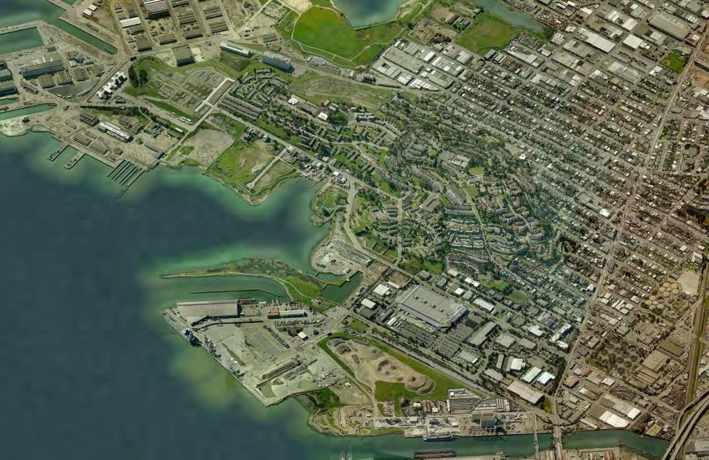
2 CARGO WAY CARGO WAY CYCLE TRACK Streetscape Concepts JENNINGS ST Illustrative Plan EVANS AVE PG&E BAY TRAIL HERON S HEAD PARK The recommended improvements build off the planned improvements from the Shipyard and PG&E projects, and incorporate proposed development projects at 700 Innes (Build Inc. Project), 900 Innes and IBSP (Recreation and Parks Department), and uphill at Hunters View. The PLANNED IMPROVEMENTS have already been funded, whereas the RECOMMENDED IMPROVEMENTS are not currently funded, but could be in the future. HUNTERS POINT BLVD In this chapter, each section of streetscape includes the following information: Existing conditions street section HUNTERS VIEW Planned improvement street section Recommended improvement street section Recommended improvement plan enlargement HAWES ST INDIA BASIN SHORELINE PARK INDIA BASIN OPEN SPACE 900 INNES Table of Contents for this Section HUNTERS POINT INNES AVE CLASS I 2-WAY CYCLE TRACK 700 INNES NORTHSIDE PARK BAY TRAIL DONAHUE ST CONNECTION TO CLASS II BIKE LANE IN SHIPYARD HUNTERS POINT SHIPYARD Street Types 62 Jennings Street 68 Evans Avenue (HPB) 72 Hunters Point Boulevard 76 Innes Avenue (Hawes to New Griffith St) 80 Innes Avenue (New Griffith St to Earl St) 86 Innes Avenue (Earl St to Donahue St) 92 New Streets in India Basin 96 MORGAN HEIGHTS India Basin - Transportation Action Plan DRAFT REPORT 59

3 This view shows the two-way cycle-track and street tree planting along Hunters Point Boulevard. The staggered 40 spacing of tall columnar trees provides an iconic streetscape with a sense of scale for users, but does not block the views of the Bay. There are continuous sidewalks with street trees and vista seating areas. The mixed shade and tall columnar canopy on the hillside of the street provides shade and character. 60 India Basin - Transportation Action Plan DRAFT REPORT FOR INTERNAL REVIEW

4 This view shows the mixed canopy planting along Innes Avenue at Griffith Street. Shade trees planted in the sidewalk extension zone help define travel lanes, which is an effective traffic calming method. The tall columnar trees provide visual continuity and occupy less space in the pedestrian realm of this constrained right-of-way. India Basin - Transportation Action Plan DRAFT REPORT 61


5 Street Types EXISTING STREET TYPES Street type classification according to Better Streets Plan Innes Avenue, Hunters Point Boulevard, and Evans Avenue up to Jennings are the primary throughway for vehicular traffic and transit. Arelious Walker is classified as a mixed use street, but has no active frontages along it. Jennings is classified as an industrial street as a result of the adjacent light industrial and manufacturing land uses and heavy semi-tractor truck traffic. Hawes, the uphill section of Innes and Middle Point are all classified as neighborhood residential streets, and are not considered main thoroughfares but still allow for local traffic and transit. Hudson, Griffith and Earl Streets are unaccepted streets that the city does not maintain for public access. STREET TYPES RESIDENTIAL/COMMERCIAL THROUGHWAY NEIGHBORHOOD COMMERCIAL MIXED USE NEIGHBORHOOD RESIDENTIAL INDUSTRIAL UNACCEPTED STREET 62 India Basin - Transportation Action Plan DRAFT REPORT FOR INTERNAL REVIEW

6 Street Types RECOMMENDED STREET TYPES The increase in traffic and transit frequency resulting from the development projects will transform the Innes/Hunters Point Boulevard/Evans corridor into a throughway similar to Guerrero or Divisadero Streets. At the same time, Innes Avenue will also serves as a commercial street with some residential frontages. For this reason, this corridor is classified as a Neighborhood Commercial Throughway with high traffic volumes and transit frequency that should also provide a generous pedestrian realm and amenities. These streets will also have sections that function more like a Residential Throughway, but the predominant type is the Neighborhood Commercial Throughway. The following are new and re-classified neighborhood commercial streets: New Griffith, Arelious Walker, Hudson (east), and New Hudson. Similar neighborhood commercial streets include Clement Street or Polk Street, where there is time-limited on-street parking and loading, and a generous pedestrian realm with amenities. Hudson (west) is re-classified as a park interior street that provides parking access for India Basin Shoreline Park and 900 Innes park. The shared streets within the Build Inc development at India Basin will be publicly-accessible private slow streets where pedestrians, bicyclists and vehicles share the same space. We recommend Jennings be re-classified to a mixed-use street to allow for the cycle track and accommodate the activation plans along the PG&E frontage. The uphill section of Innes and Middle Point remain neighborhood residential streets. The Middle Point streetscape is being improved as part of the Hunters View redevelopment project. Similar improvements are recommended for the uphill section of Innes. STREET TYPES RESIDENTIAL/COMMERCIAL THROUGHWAY NEIGHBORHOOD COMMERCIAL MIXED USE NEIGHBORHOOD RESIDENTIAL PARK INTERIOR SHARED STREET India Basin - Transportation Action Plan DRAFT REPORT 63

7 Streetscape Elements BETTER STREETS PLAN (2010) Street Classification The recommended street classification for Innes Avenue, Hunters Point Boulevard and Evans Avenue is a hybrid Neighborhood Commercial Throughway and a Residential Throughway. The following are the characteristics described in the Better Streets Plan for Neighborhood Commercial Throughways: Sidewalk Width Minimum width 12 Recommended width 15 Curb Ramps Marked Crosswalks Ped Signals - count down crossings Corner Curb Extensions Street Trees Tree grates maybe in commercial areas Sidewalk Planters planter boxes at commercial areas planter strips at other areas Stormwater Controls Pedestrian Lights at corners in commercial areas Special Paving in furnishing zones in commercial areas Site Furnishings The sidewalk widths and zones described in Chapter 4 of the Better Streets Plan establish specific areas of the pedestrian realm. These zones are cross-referenced with specific street types to recommend ideal widths of each zone for each street type. The following recommended widths apply to the Neighborhood Commercial Throughway. Frontage Zone 2 minimum The area adjacent to the property line where transitions between the public sidewalk and the space within buildings occur Throughway Zone 6 minimum, wider if higher pedestrian volumes expected The portion of the sidewalk for pedestrian travel along the street Edge Zone 2 with parking and planting The area used by people getting in and out of vehicles parked at the curbside Extension Zone width as needed The area where pedestrian space may be extended into the parking lane, via features such as bulb-outs with mid-block plazas Curb Radii Curb radii are drawn at a standard 15 radius, but subject to engineering review for specific performance requirements. Curb returns are drawn at the city allowable standard of 15 and 10 radii. Furnishing Zone 4 or wider The portion of the sidewalk used for street trees, landscaping, transit stops, street lights, and site furnishings FRONTAGE ZONE THRU ZONE FURNISHING ZONE EDGE EXTENSION ZONE 64 India Basin - Transportation Action Plan DRAFT REPORT FOR INTERNAL REVIEW
8 Streetscape Elements HOW THE IMPROVEMENTS WORK TOGETHER Parking lane defined with different paving and bulb-outs Unit pavers in furnishing zone Tall columnar trees in furnishing zone Shade trees in sidewalk extension zone Standard sidewalk in through zone Existing trees Special paving in transit stop sidewalk extension Flow-through planter next to trees Special paving in furnishing zone THRU 6-0 FURN 4-0 EXTENSION 8-0 AUTO/BUS 12-0 AUTO 10-0 AUTO 10-0 AUTO/BUS 12-0 EXTENSION 8-0 FURN 4-0 Special paving in driveway extension THRU 6-0 India Basin - Transportation Action Plan DRAFT REPORT 65


9 Streetscape Concepts Parking Trade-Offs 10X 12X B U S In the constrained right of way along Innes Avenue, there is a clear trade off between parking spaces and pedestrian realm improvements. This report attempts to balance on-street parking with pedestrian realm improvements. The EXTENSION ZONE is the area where the trade-offs will occur. DRIVEWAY EXTENSION: Areas with existing driveways are extended out to the travel lanes to allow for expanded pedestrian realm amenities. The driveway extension also creates a protected loading zone. 2X TRANSIT SHELTER: Bulb-outs for transit shelters will be necessary in areas where sidewalks are constrained. BICYCLE PARKING: Bicycle corral parking for ten bikes can replace the space one car occupies. STORMWATER BIOSWALE PLANTER MID-BLOCK PEDESTRIAN CROSSING STORMWATER BIOSWALE PLANTER SEATING: Businesses may choose to convert the parking spaces in front of their properties into other types of public space amenities, such as parklets. PLANTING: Long stretches of parking with no active frontages can be broken up with planted bulb-outs, which help better define parking spots and travel lanes. AUTO PARKING SPOT DRIVEWAY EXTENSION FURNISHING ZONE 10X AUTO PARKING SPOT 66 BICYCLE PARKING India Basin - Transportation Action Plan DRAFT REPORT FOR INTERNAL REVIEW 2X 12X SEATING/ FURNISHING ZONE B U S TRANSIT SHELTER PLANTING/ FURNISHING ZONE DRIVEWAY EXTENSION PARKING/PLANTING
PUBLIC REALM MASTER PLAN
 WESTSHORE BUSINESS DISTRICT PUBLIC REALM MASTER PLAN MASTER PLAN COMMITTEE MEETING MARCH 20, 2013 WESTSHORE BUSINESS DISTRCT PUBLIC REALM MASTER PLAN MACRO-SCALE CONCEPT: A PUBLIC REALM FRAMEWORK DEFINED
Bicycle and Pedestrian Advisory Committee (BPAC) November 21, 2013
 November 21, 2013") Bicycle and Pedestrian Advisory Committee (BPAC) November 21, 2013 OVERALL LAND USE CONCEPT Overall Broadway Valdez District: 95.5 acres (35.1 acres right-of ways + 60.4 acres developable land) Plan Subareas:
Bicycle and Pedestrian Advisory Committee (BPAC) November 21, 2013 OVERALL LAND USE CONCEPT Overall Broadway Valdez District: 95.5 acres (35.1 acres right-of ways + 60.4 acres developable land) Plan Subareas:
5 CIRCULATION AND STREET DESIGN
 5 CIRCULATION AND STREET DESIGN This chapter describes circulation and streetscape improvements proposed for the Northwest Chico Specific Plan Area. It includes detailed design specifications for existing
Item to be Addressed Checklist Consideration YES NO N/A Required Description Complete Streets Guidelines
 Passaic County Complete Streets Checklist - Concept Development Project Name Item to be Addressed Checklist Consideration YES NO N/A Required Description Complete Streets Guidelines Existing Plans Have
THE ALAMEDA CONCEPT DESIGN COMMUNITY MEETING 3. A Plan for The Beautiful Way JANUARY 28, 2010
 CONCEPT DESIGN COMMUNITY MEETING 3 JANUARY 28, 2010 AGENDA INTRODUCTION COMMUNITY INPUT ROADWAY STUDIES STREETSCAPE DESIGN STATIONS DISCUSSION SUMMARY AND DISCUSSION NEXT STEPS CLOSE INTRODUCTION SCHEDULE
STEERING COMMITTEE MEETING June 17, Streetscape Overview Burlington Comprehensive Master Plan
 STEERING COMMITTEE MEETING June 17, 2015 Streetscape Overview Burlington Comprehensive Master Plan 1 Introduction Slide This slide show was presented to the Burlington Steering Committee on June 17, 2015
DRAFT - CITY OF MEDFORD TRANSPORTATION SYSTEM PLAN Roadway Cross-Sections
 Roadway Cross-Sections Medford s roadway cross-section standards apply to new and reconstructed roads. The crosssections take into consideration roadway function and operational characteristics, including
Chapter 3: Multi-Modal Circulation and Streetscapes
 CHAPTER 3: MULTI-MODAL CIRCULATION AND STREETSCAPES Chapter 3: Multi-Modal Circulation and Streetscapes Overview Streetscape improvements have already been completed for Depot Street between Main Avenue
COWETA HIGH SCHOOL AND EAST HIGHWAY 51
 COWETA HIGH SCHOOL AND EAST HIGHWAY 51 Lack of sidewalks along Ben Lumpkin Rd. Lack of crosswalks and ramps at intersection. Hwy 51 is wide to cross as a pedestrian. No ADA compliance or connection to
NEWMARKET UPHAM S CORNER
 SOUTH STATION Planning Initiative NEWMARKET UPHAM S CORNER COLUMBIA ROAD (P) FOUR CORNERS/GENEVA Working Advisory Group (WAG) Meeting #5 TALBOT AVENUE MORTON STREET BLUE HILL AVE/CUMMINS HWY (P) RIVER
Designing Complete Streets: What you need to know
 Designing Complete Streets: What you need to know Getting from this to this. Continuous sidewalk Buffer w/trees Bicycle lane Raised median Buildings close to the street Flexibility in design Design and
Community Meeting February 27, 2007 Dorchester Avenue Transportation & Streetscape Improvements Action Plan February 27, 2007
 Community Meeting Tonight s Agenda 6:00 Introductions South Boston/Dot Ave Improvement Study Background 6:15 Consultant Introductions Review of Scope and Schedule Review of Proposed Corridor Wide Guidelines
WORKSHOP 2 SUMMARY OVERVIEW GENERAL COMMENTS. Walking and Biking. Greening & Stormwater. Transportation & Parking. Lighting, Art and Identity
 WORKSHOP 2 SUMMARY OVERVIEW On May 9, 2016, 55 people came to the second public meeting for the Lower Haight Public Realm Plan. Roughly 34 of attendees were neighborhood residents. The open house was a
APPENDIX A: Complete Streets Checklist DRAFT NOVEMBER 2016
 APPENDIX A: Complete Streets Checklist DRAFT NOVEMBER 2016 Complete Streets Checklist MetroPlan Orlando s Complete Streets Checklist is an internal planning tool for staff to further implementation of
What Is a Complete Street?
 Session 5 Charleen Zimmer, AICP, Zan Associates May 5-7, 2010 What Is a Complete Street? May 2010 5-1 Not a Complete Street More of a Complete Street May 2010 5-2 Benefits of Complete Streets Safety for
TRANSPORTATION COMMISSION Agenda Staff Report
 TRANSPORTATION COMMISSION Agenda Staff Report Agenda Item No. 5.a DATE: JULY 31, 2014 TO: FROM: SUBJECT: TRANSPORTATION COMMISSION COMMUNITY DEVELOPMENT DEPARTMENT - PLANNING DRAFT OLYMPIC CORRIDOR PREFERRED
Aurora Urban Street Standards For Transit Oriented Developments and Urban Centers
 Aurora Urban Street Standards For Transit Oriented Developments and Urban Centers I. Purpose These standards will be applied to create a safe, comfortable, pleasant and pedestrian-friendly multi-modal
Bridges and Arizona Crossings
 Circulation and Transportation 5-11 Discovery Street/Barham Drive. Discovery Street is planned 5.4.3 Specific Plan Circulation Improvements to be extended eastward from its terminus at Craven Road Circulation
6.4 RECOMMENDED IMPROVEMENTS
 6.4 RECOMMENDED IMPROVEMENTS 6.4.1 Williston Road Recommendations While all alternatives would be an improvement over existing conditions, Alternative 3B is recommended over the others because it provides
NJDOT Complete Streets Checklist
 Background The New Jersey Department of Transportation s Complete Streets Policy promotes a comprehensive, integrated, connected multi-modal network by providing connections to bicycling and walking trip
ROUTE 81 CORRIDOR STUDY DESIGN CONCEPTS
 RT 81 Corridor Study CLINTON ROUTE 81 CORRIDOR STUDY DESIGN CONCEPTS View north on High Street, with potential improvements to the streetscape Draft Recommendations November 8 th, 2018 TOWN OF CLINTON
A CHANGING CITY. of Edmonton, it is essential that it reflects the long-term vision of the City.
 A CHANGING CITY By the year 2040, Edmonton will be home to more than 1 million people. To accommodate growth and support a healthy and compact city, we need a new approach to development/redevelopment
Figure 5-1 Complete Street Zones. Roadside. May include frontage, pedestrian throughway, furnishings and curbside areas.
 Design Guidelines 5 The design guidelines presented in this section provide descriptions related to the form and function of the four Complete Streets zones: roadside, parking, roadways and lanes, median,
PROJECT KEY TYPICAL SECTION 1 =60
 6 WASHINGTON BLVD - BETWEEN NE 1ST ST AND NE 3RD ST Washington Boulevard is a low volume, low speed one-way road, signed for no street between NE 1st Street and NE 2nd Street, and closed to traffic between
WELCOME. Thank you for joining us at the Second Public Workshop for the Carlsbad Pedestrian Master Plan. We look forward to receiving your feedback.
 City of Carlsbad Pedestrian Master Plan: WELCOME WELCOME Please Sign In Provide Input at Flip Charts Review Boards Presentation of Draft Plan Thank you for joining us at the Second Public Workshop for
TRANSPORTATION STANDARDS
 INTRODUCTION LOCAL STREETS ON-STREET PARKING SIDEWALKS STREET LIGHTING STREET FURNISHINGS TRAFFIC CALMING STREET TREES MEDIAN PLANTING BOULEVARD LOCATIONS VILLAGE CENTER STREET LOCATIONS RESIDENTIAL STREET
complete streets design and construction standards public primer City of Edmonton
 complete streets design and construction standards public primer City of Edmonton introduction Complete Streets are streets for everyone: people who walk, wheel, bike, take transit, or drive. They are
WHEREAS delivery trucks also pass through the Narrows, into the northern parking lot, to loading docks in the back of the building.
 CEDAR-ISLES-DEAN NEIGHBORHOOD ASSOCIATION ( CIDNA ) RESOLUTION OPPOSING A DRUG STORE DRIVE THRU, AND COMMENDING DORAN COMPANIES FOR PROPOSING MITIGATING AMENITIES INCLUDING NEW LANDSCAPING AND A DEDICATED
Vision: Traditional hamlet with an attractive business/pedestrian friendly main street connected to adjacent walkable neighborhoods
 N D. Focus Area II Vision: Traditional hamlet with an attractive business/pedestrian friendly main street connected to adjacent walkable neighborhoods Transit Road Focus Area II is located in the Hamlet
12/4/2016 VIA . RE: Grocery Outlet Del Paso (DR16-328)
") 12/4/2016 VIA EMAIL Ethan Meltzer, Assistant Planner City of Sacramento Community Development Department 300 Richards Blvd, 3 rd Floor Sacramento, CA 95811 RE: Grocery Outlet Del Paso (DR16-328) Dear Mr.
12/4/2016 VIA EMAIL Ethan Meltzer, Assistant Planner City of Sacramento Community Development Department 300 Richards Blvd, 3 rd Floor Sacramento, CA 95811 RE: Grocery Outlet Del Paso (DR16-328) Dear Mr.
CURBSIDE ACTIVITY DESIGN
 5 CURBSIDE ACTIVITY DESIGN This chapter provides design guidance for separated bike lanes adjacent to curbside activities including parking, loading and bus stops. Typical configurations are presented
Southview Blvd & 3 rd Avenue Improvement Project. Public Open House December 4, to 7pm
 Southview Blvd & 3 rd Avenue Improvement Project Public Open House December 4, 2014 5 to 7pm Southview Blvd & 3 rd Avenue Public Information Meeting Agenda Presentation 5:30 to 6:15 pm Purpose of Project
Transportation Planning Division
 Transportation Planning Division Presentation Outline Study Tasks Recap of Previous Meetings Data Collected Focus Areas within Study Limits Design Principles Tool Box Recommended Concepts Schedule Moving
FONTAINE AVENUE STUDY Final Report
 FONTAINE AVENUE STUDY Final Report March 28, 2005 FONTAINE AVENUE STUDY City of Charlottesville March 28, 2005 Renaissance Planning Group Kenneth Schwartz, FAIA, AICP Director of Design Leigh Wilkerson,
7/23/2017 VIA . Michael Hanebutt City of Sacramento Community Development Department 300 Richards Boulevard, 3 rd Floor Sacramento, CA 95811
 7/23/2017 VIA EMAIL Michael Hanebutt City of Sacramento Community Development Department 300 Richards Boulevard, 3 rd Floor Sacramento, CA 95811 RE: 65 th Street Apartments (DR17-220) Dear Mr. Hanebutt:
MUNICIPALITY OF ANCHORAGE Traffic Department MEMORANDUM
 MUNICIPALITY OF ANCHORAGE DATE: MEMORANDUM TO: FROM: SUBJECT: Anchorage Contractors, Builders, Designers, and Land Owners Robert E. Kniefel, P.E., Municipal Traffic Engineer Municipal Driveway Standards
Palou Complete Street Project Barneveld Avenue to Crisp Road Project overview and concept design Community Meeting #2 May 13, 2015
 Palou Complete Street Project Barneveld Avenue to Crisp Road Project overview and concept design Community Meeting #2 May 13, 2015 Agenda Welcome and introductions Project overview, history and goals Concept
Complete Streets. Designing Streets for Everyone. Sarnia
 Complete Streets Designing Streets for Everyone Sarnia Complete Streets ~ Sarnia ~ 2018 Introduction Our City is made up of a network of streets that we use to go for a walk, cycle to work, drive to the
Section 7 Complete Green Street Guidelines DRAFT
 Section 7 Complete Green Street Guidelines DRAFT 1 Section: 7.0 COMPLETE GREEN STREET GUIDELINES These guidelines serve as options to mitigate the environmental impact of a project as well as guide the
Off-road Trails. Guidance
 Off-road Trails Off-road trails are shared use paths located on an independent alignment that provide two-way travel for people walking, bicycling, and other non-motorized users. Trails specifically along
Omaha s Complete Streets Policy
 Omaha s Complete Streets Policy (Adopted August 2015) VISION To create great places and enhance our quality of life, the City of Omaha will provide safe, accessible streets for all users. Complete Streets
Memo. Ocean Avenue Corridor Design Project Public Workshop #2 Summary
 Ocean Avenue Corridor Design Project Public Workshop #2 Summary The second public workshop for the Ocean Avenue Corridor Design Project was held on Wednesday, May 14, 2014 from, 6 to 8 pm at Lick Wilmerding
UDC Street Cross Sections
 UDC Street Cross Sections Local Street - Downtown Local Street Mountable Curb Local Street Vertical Curb Alley Major Arterial Minor Arterial Residential Lane Residential Collector Residential Collector
MASONIC AVENUE STREET DESIGN STUDY Community Workshop 3. Masonic Ave Street Design Study Community Workshop 3 September 30, 2010
 Masonic Ave Street Design Study Community Workshop 3 September 30, 2010 Introduction MASONIC AVENUE STREET DESIGN STUDY Community Workshop 3 SF Municipal Transportation Agency Javad Mirabdal, Project Manager
Polk Streetscape Project
 What is this project? The Polk Streetscape Project is an effort to improve safety for everyone traveling on Polk Street between Union and McAllister streets. Also included in this project are paving, sewer
Tonight is for you. Learn everything you can. Share all your ideas.
 Strathcona Neighbourhood Renewal Draft Concept Design Tonight is for you. Learn everything you can. Share all your ideas. What is Neighbourhood Renewal? Creating a design with you for your neighbourhood.
FOLSOM-HOWARD STREETSCAPE OVERVIEW
 FOLSOM-HOWARD STREETSCAPE OVERVIEW SoMa residents should have the same kinds of amenities that other neighborhoods have. The Folsom- Howard Streetscape Project will make SoMa more livable by making it
City of Seattle Edward B. Murray, Mayor
 City of Seattle Edward B. Murray, Mayor Department of Transportation Scott Kubly, Director Eastlake Community Council 117 E Louisa St. #1 Seattle, WA 98102-3278 January 28, 2016 RE: Roosevelt to Downtown
Figure 4-10: Pedestrian Improvements Types of Potential Station Area Improvements - Place-Making Improvements
 INCORPORATE FEATURE PAVIN IN CROSSWALK AND INTERSECTION FIELDS Identifies high-priority pedestrian areas and create a station identity through colorful and interesting patterns ADD CURB EXTENSIONS Extending
Paoli Road Improvement Feasibility Study
 Paoli Road Improvement Feasibility Study & Public Participation Project March 24, 2015 Prepared for: Tredyffrin Township Prepared by: McMahon Associates, Inc. with Town Planning Partnership, LLC Glackin
DRAFT BETTER STREETS PLAN PLAN REVISIONS 2) ATTACHMENTS
 ATTACHMENTS") DRAFT BETTER STREETS PLAN PLAN REVISIONS 2) ATTACHMENTS OCTOBER 2009 Attachment A 10/14/2009 * This section would be added as a sidebar in Chapter 2 (Section 2.3, page 28) of the Draft Better Streets Plan.
DRAFT BETTER STREETS PLAN PLAN REVISIONS 2) ATTACHMENTS OCTOBER 2009 Attachment A 10/14/2009 * This section would be added as a sidebar in Chapter 2 (Section 2.3, page 28) of the Draft Better Streets Plan.
ARLINGTON COUNTY, VIRGINIA
 ARLINGTON COUNTY, VIRGINIA County Board Agenda Item Meeting of October 15, 2016 DATE: October 7, 2016 SUBJECT: Adoption of amendments to the Master Transportation Plan (MTP) to create a new Pedestrian
Arapahoe Square Zoning + Design Standards & Guidelines Task Force Meeting 9 January 27, 2016
 Arapahoe Square Zoning + Design Standards & Guidelines Task Force Meeting 9 January 27, 2016 Agenda 3:00 Opening/Welcome 3:15 Touch Base on Schedule and Milestones Moving Forward 3:20 Review the Overall
Illustrated Principles of Good Planning
 Illustrated Principles of Good Planning The Miami 21 Zoning Code incorporates time-tested planning principles into the zoning regulations of our City. These are principles that make for better neighborhoods,
FOCUS AREA 1 - Alberta Avenue Pocket Park 3 (121 Ave and 92 St)
") FOCUS AREA 1 - Alberta Avenue Pocket Park 3 (121 Ave and 92 St) New benches Plant evergreen trees Widen existing sidewalk from 1.5m to 1.8m Marked crosswalk 1.8m wide sidewalk Add pedestrian oriented lights
FOCUS AREA 1 - Alberta Avenue Pocket Park 3 (121 Ave and 92 St) New benches Plant evergreen trees Widen existing sidewalk from 1.5m to 1.8m Marked crosswalk 1.8m wide sidewalk Add pedestrian oriented lights
PEDESTRIAN CIRCULATION & STREETSCAPE DESIGN
 CHAPTER 4 Chapter 4 Pedestrian Circulation & Trails PEDESTRIAN CIRCULATION & STREETSCAPE DESIGN In recent years, the City has constructed new sidewalks and enhanced existing ones in the downtown with brick
Prince George s County plans, policies, and projects
 Prince George s County plans, policies, and projects Over 250 projects for trails, bikeways, designated bike lanes and sidewalk construction Trail projects that improve access to Metro Sidewalk and trail
Active Transportation Rail to River Corridor. Community Meeting - Segment A
 Active Transportation Rail to River Corridor Community Meeting - Segment A June 29, 2017 Tonight s Agenda > Open House (30 min) > Welcome / Project Overview > Presentation of 30% Design Refinements > Next
Report. Typical Sections. City of Middleton, WI
 Report Typical Sections City of Middleton, WI December 2006 Report for City of Middleton, Wisconsin Typical Sections repared by: Traffic Associates LLC and STRAND ASSOCIATES, INC. 910 West Wingra Drive
Appendix 3 Roadway and Bike/Ped Design Standards
 Appendix 3 Roadway and Bike/Ped Design Standards OTO Transportation Plan 2040 4/20/2017 Page A3-1 Adopted Standards The adopted OTO Design Standards and Major Thoroughfare Plan are contained herein.
CURB EXTENSIONS BULB OUTS DPS 201 NECKDOWNS
 CURB EXTENSIONS BULB OUTS DPS 201 NECKDOWNS WHY WHEN & WHERE When Limited Sight Distance Pedestrians & Vehicles Vehicles and Signs Want to put two curb ramps in Discourage High speed turning High number
Lawrence Avenue Streetscape Concepts August 30, 2011
 Lawrence Avenue Streetscape Concepts August 30, 2011 Neighborhood Context Phase II: River to Western Ave. Phase I: Western Ave. to Clark St. Key Map Lawrence Ave. Existing Streetscape Conditions East of
Toronto Complete Streets Guidelines
 Toronto Complete Streets Guidelines 18 20 2.1 Understanding Street Type 22 2.2 Use of Overlays 23 2.3 Toronto Understanding the roles and relationships of a street with its surrounding context is a critical
Street Design Workshop. Existing cross section Traffic volumes Examine adjacent land uses You design future improvements
 Street Design Workshop Existing cross section Traffic volumes Examine adjacent land uses You design future improvements Primary Tools for Street Redesign Road diets Bike lanes Cycle tracks Trails Crosswalks
Ocean Park Boulevard Green Street Project Alternatives & Trade Offs
 Planning Commission March 4, 2009 Ocean Park Boulevard Green Street Project Alternatives & Trade Offs Purpose of Tonight s Meeting Review concept plans and options Provide input on alternatives and trade-offs
MASONIC AVENUE STREET DESIGN STUDY Community Workshop 2. Masonic Ave Street Design Study Community Workshop 2 August 10, 2010
 Masonic Ave Street Design Study Community Workshop 2 August 10, 2010 Introduction MASONIC AVENUE STREET DESIGN STUDY Community Workshop 2 SF Municipal Transportation Agency Javad Mirabdal, Project Manager
Mission-Geneva Transportation Study Community Workshop 2 July 8, 2006
 Community Workshop 2 July 8, 2006 Small Group Workbook 1 Basic Improvements on Mission Street Streetscape. Pedestrian-scale lighting; landscaping; community art on utility boxes; more (possibly unique)
o n - m o t o r i z e d transportation is an overlooked element that can greatly enhance the overall quality of life for the community s residents.
 N o n - m o t o r i z e d transportation is an overlooked element that can greatly enhance the overall quality of life for the community s residents. 84 Transportation CHAPTER 11 INTRODUCTION Transportation
Table #6 VISION CHARACTERISTICS
 Table #6 VISION White Flint is a place to live, work, play, shop, and walk with sufficient density to encourage quality redevelopment. Vibrant streets and consistent streetscapes are important. CHARACTERISTICS
Appendix B - Street Sections
 Appendix B - Street Sections 6TH STREET CORRIDOR PLAN STREET SECTIONS The street sections in Appendix B include recommended improvements to streets for North Glenwood. They include existing conditions
Long Island Rail Road Expansion Project Floral Park to Hicksville
 Long Island Rail Road Expansion Project Floral Park to Hicksville Final Environmental Impact Statement Appendix 1-D Complete Streets Policy Checklist April 2017 0902ML PIN: Project Location: 18A-4 Floral
Chapter 3 BUS IMPROVEMENT CONCEPTS
 Chapter 3 BUS IMPROVEMENT CONCEPTS The purpose of this chapter is to describe potential bus improvement strategies and potential impacts or implications associated with BRT implementation within the existing
HARRISON STREET/OAKLAND AVENUE COMMUNITY TRANSPORTATION PLAN
 HARRISON STREET/OAKLAND AVENUE Community Workshop #4: Draft Plan Review December 3, 2009 D E S I G N, C O M M U N I T Y & E N V I R O N M E N T INTRODUCTIONS Key Project Staff: Alisa Shen, Project Manager,
Multimodal Through Corridors and Placemaking Corridors
 68 Multimodal Through Corridors and Placemaking Corridors Corridors have different functions in a region. Some corridors are used to get smoothly and rapidly through a region or to get quickly to major
CONTEXT SENSITIVE STREETS STANDARDS COMMITTEE
 CONTEXT SENSITIVE STREETS STANDARDS COMMITTEE February 23, 2015 Prepared by: Denise Chaplick, AICP City Jacksonville Bicycle and Pedestrian Coordinator Source: NCDOT Complete Streets Planning and Design
14 TH STREET TRANSPORTATION & STREETSCAPE DESIGN STUDY PLAN B PLAN B TRANSPORTATION & STREETSCAPE RECOMMENDATIONS
 14 TH STREET TRANSPORTATION & STREETSCAPE DESIGN STUDY PLAN B PLAN B TRANSPORTATION & STREETSCAPE RECOMMENDATIONS 141 Symbols Recommendations - Southern End of 14th Street Study Area Streetscape Each icon
Las Tunas Downtown Revitalization City Council Study Session. December 1, :00 p.m. Live Oak Park Community Center
 Las Tunas Downtown Revitalization City Council Study Session December 1, 2015 7:00 p.m. Live Oak Park Community Center AGENDA 2 Provide downtown context. Confirm project goals. Analyze three design concepts.
SAN FRANCISCO MUNICIPAL TRANSPORTATION AGENCY
 THIS PRINT COVERS CALENDAR ITEM NO. : 10.3 DIVISION: Sustainable Streets Division BRIEF DESCRIPTION: SAN FRANCISCO MUNICIPAL TRANSPORTATION AGENCY Approving traffic and parking modifications to install
Morristown, NJ Complete Streets Policy
 Morristown, NJ Complete Streets Policy Introduction A Complete Street is defined as a means to provide safe access for all users by designing and operating a comprehensive, integrated, connected multi-modal
Southside Pilot Proposal
 To improve bicycle access and mobility to UC Berkeley, Downtown Berkeley, and the Southside area, a pilot project could include a two-way parking-protected cycle track. Turn pockets and island bus stops
REGIONAL BICYCLE AND PEDESTRIAN DESIGN GUIDELINES
 REGIONAL BICYCLE AND PEDESTRIAN DESIGN GUIDELINES November 16, 2011 Deb Humphreys North Central Texas Council of Governments Bicycle and Pedestrian Advisory Committee Snapshot of the Guide 1. Introduction
Road Diets FDOT Process
 Florida Department of TRANSPORTATION Road Diets FDOT Process Humberto Castillero, PE, PTOE Roadway Design Office Purpose of Guide Develop a statewide lane elimination review process Balance state & local
PRINCE GEORGE S PLAZA METRO AREA PEDESTRIAN PLAN
 PRINCE GEORGE S PLAZA METRO AREA PEDESTRIAN PLAN May 28, 2008 Agenda Welcome and introductions Project overview and issue identification Planning context and strengths Design challenges and initial recommendations
TRAFFIC ACTION PLAN. Laurie Meadows Neighborhood CITY OF SAN MATEO
 TRAFFIC ACTION PLAN Laurie Meadows Neighborhood CITY OF SAN MATEO Draft January 2017 Table of Contents Introduction... 2 The Traffic Forum Process... 5 Neighborhood Traffic Issues... 7 Neighborhood Recommendations
STREETSCAPE CONCEPT PLAN
 03 STREETSCAPE CONCEPT PLAN Zone 1 This zone includes the gateway into both the downtown and the Village at Harlem. The gateway features are shown closer to the Harlem intersection to make them more prominent.
Active Transportation Facility Glossary
 Active Transportation Facility Glossary This document defines different active transportation facilities and suggests appropriate corridor types. Click on a facility type to jump to its definition. Bike
CHAPTER. Design Toolkit
 CHAPTER Design Toolkit Chapter 5: Design Toolkit 65 TOOLKIT OVERVIEW The Green Connections Design Toolkit is a resource for community members, city agencies and designers when developing and implementing
DEFINING THE STREETSCAPE DRAFT
 3 DEFINING THE STREETSCAPE Context Sensitive Design Context Sensitive Design The structuring elements of streetscapes for the City of Vaughan are road classifi cation, streetscape type and level of service.
/ ARLINGTON COUNTY, VIRGINIA
 / ARLINGTON COUNTY, VIRGINIA County Board Agenda Item Meeting of September 24, 2016 DATE: August 11, 2016 SUBJECT: Amendment of the Master Transportation Plan (MTP) Streets Element to include new local
Implementation challenge 2: Is there room for Complete Streets? Does street classification enable Complete Streets?
 Implementation challenge 2: Is there room for Complete Streets? Does street classification enable Complete Streets? 1 Do we have to widen roads to fit everything? 2 There s room; it needs to be recaptured
Chapter 3 DESIGN SPECIFICATIONS
 Brampton PathWays Planning and Design Guidelines 27 Chapter 3 DESIGN SPECIFICATIONS 3.1 CLASS 1 MULTI-USE PATH Off-road multi-use trails are the backbone of the Brampton PathWays Network. They are typically
Streetscape: Core Shopping District
 Streetscape: Core Shopping District DRAFT DRAFT DRAFT May 00 Core Shopping District: Phase Blue Island s Core Shopping District is located along Western Avenue, between Grove and Union Streets. Streetscape
RZC Appendix 8A Marymoor Subarea Street Requirements
 RZC Appendix 8A Marymoor Subarea Street Requirements For additional design details for Marymoor Subarea infrastructure, refer to the 2017 Marymoor Subarea Infrastructure Planning Report. STREET REQUIREMENTS
DESIGN CODE. Enterprise West Harlow London Road North Design Code 21
 DESIGN CODE Enterprise West Essex @ Harlow London Road North Design Code 21 4 MAXIMUM BUILDING HEIGHTS 4.1 Table 4A sets out maximum building height standards for each character area within the LDO boundary.
Options. Agenda. Program
 July 2013 Workshops Agenda Parc 55 Main Library Open house 6-6:15pm 10-10:15am Presentation 6:15-7:00pm 10:15-11am Exhibit stations review & comments 7-8:20pm 11am - 12:20pm Meeting close 8:20-8:30pm 12:20-12:30pm
Ocean Park Boulevard Green Street Project Community Workshop
 Ocean Park Boulevard Green Street Project Community Workshop 2.2.10 Project Objectives Community Priority: reclaim OPB for public open space. Build upon LUCE principles; neighborhood enhancement, connectivity,
MARTIN LUTHER KING JR. WAY
 OCTOBER 2011 40 Vision and Goals The Martin Luther King, Jr. Way Illustrative Master Plan that follows has been developed through a process of community involvement. It expresses a long term vision for
El Camino Real Specific Plan. TAC/CAC Meeting #2 Aug 1, 2018
 El Camino Real Specific Plan TAC/CAC Meeting #2 Aug 1, 2018 Land Use Alternatives Goals and Tradeoffs Parks & open space Housing Retail & services Civic spaces Parking Community gathering spaces 3 Alternatives
KEARNY MESA COMMUNITY PLAN UPDATE
 KEARNY MESA COMMUNITY PLAN UPDATE January 18, 2018 SUBCOMMITTEE MEETING Mobility Concepts and Urban Design Presentation Outline Mobility Concepts: Multimodal Planning Toolbox Presentation and Activities
s a n f r a n c i s c o
 s a n f r a n c i s c o BETTER STREETS PLAN Policies and Guidelines for the Pedestrian Realm F I N A L D R A F T R E L E A S E P A C K E T J U L Y 2 0 1 0 i n s i d e : L E T T E R F R O M M A Y O R G