4 Land Use and Building Design
|
|
|
- Ariel Montgomery
- 6 years ago
- Views:
Transcription
1 4 Land Use and Building Design Land use and building design interact with the streetscape and public realm to establish a sense of place and neighborhood character. This section outlines the land use strategy for the Planning Area and provides a framework for building design, which will be further developed during the next planning stage. 4.1 Land Use Character LAND USE CHARACTER The Station Area Plan will promote a diversity of uses within the Planning Area that complement each other and ensure an active urban neighborhood at all hours. The land use character map (Figure 4-1) shows character differences within the mixed-use context throughout the Planning Area. The land use character concept includes a range of flexible mixed use areas intended to encourage vibrant pedestrian corridors. These are complemented by highdensity housing and commercial uses, and new public spaces. Desired land use character will be achieved through a range of regulatory mechanisms such as land use regulations, development standards, street improvements, and design guidelines.
2 . VICTO T Lake Merritt 880 FIGURES 49 E AV A HOL AT A E. 18TH 18TH ST ST T FOOTHILL O ILL B LVD E. 15TH ST 1ST AVE 3RD AVE INTERNATIONAL B LVD 4TH AVE E. 11TH ST 5TH AVE EMBARCADERO R E LAKESHORE AV A R CT RY FALLON ST EMBAR ARCADE ADERO WEST 17TH ST 15TH ST 2ND ST 5TH ST 4TH ST 3RD ST 4TH ST BRO ADW AY BRO ADW AY FRANKLIN ST FRANKLIN ST WEBSTER ST HARRISON ST ALICE ST MADISON ST JACKSON ST OAK ST LAKESIDE DR 1 2th St BART 14TH ST 13TH ST 12TH ST 11TH ST Lincoln Square Park 10TH ST 7TH ST AMTRAK 6TH ST 1ST ST R-90 R FEET 2ND AVE E. 12TH ST E. 10TH ST E. 7TH ST WEBSTER PL HARRISON ST JACKSON ST MADISON ST OAK ST 9TH ST 8TH ST Post Office Lincoln Elementa ry Public Library MTC/ ABAG County Court WEBSTER ST ALICE ST Pacific Renaissance Plaza Chinese Garden Park Lake Merritt BART BART Parking Laney College Oakland Unified School District Oakland Unified School District Downtown Campus Peralta Community College District Administration LA L KESIDE DR ST TUNNEL Oakland Museum of California Kaiser Auditorium Laney Parking Figure 4.1: DRAFT LAND USE CHARACTER Pedestrian Zone Pedestrian Transition Zone Flex Zone Commercial Zone Institutional Zone Open Space Zone Residential RU-5 Zones 11TH Madison Square Park
3 Lake Merritt Station Area Plan Draft Emerging Plan Analysis Report Pedestrian Zone. An area of mixed-use, pedestrian-oriented continuous storefront uses with a mix of retail, restaurants, and business and social services. Upper story spaces are intended to be available for a wide range of residential and commercial activities. Transition Zone. An area that is currently mostly housing, but allows for the gradual transition to a Pedestrian Area by requiring ground floor storefront uses in new buildings. Flex Zone. An area allowing the maximum flexibility in uses, and permitting a variety of commercial, residential and even some light industrial uses. Commercial Zone. An area allowing a wide range of ground floor office and other commercial activities, with primarily office uses on upper floors. Institutional Zone. An area appropriate for educational facilities, cultural uses, health services, and other uses of a similar character, such as Laney College, Peralta College District, Oakland Museum, and Kaiser Auditorium. Open Space Zone. An area intended to meet the active and passive recreational needs of Oakland residents. An Open Space designation along the Lake Merritt Estuary channel would allow uses and facilities that enhance this regional asset. Residential Zone. An area appropriate for multi-unit, mid-rise or high-rise residential structures in locations with good access to transportation and other services. A residentially focused area would also allow a variety of ground floor uses that are compatible with a residential area. 4.2 Active Ground Floor Uses EXISTING RETAIL CONTEXT The Planning Area includes Chinatown, which is a unique and rich environment, with a wealth of cultural, social, medical, residential, retail and social resources. The Chinatown commercial core is one of the city s most vibrant neighborhood retail districts. Over the last three decades, Asian-oriented retail has also spread eastward in Oakland along 12th Street and International Boulevard. The Planning Area (extending from 5th Avenue to Broadway and 5th Street to International Boulevard and 14th Street) had reported sales of $57 million in 2008, making it the city s fifth largest neighborhood retail district in terms of sales. Of this area, historic Chinatown is the most concentrated retail area in the Planning Area, located between 7th, 11th, Franklin, and Harrison Streets. Since 1994, retail sales in Chinatown have grown at a much faster pace (84%) than for the city as a whole (1.74%). Chinatown is unique among Oakland s retail districts in that it regularly draws shoppers to Oakland from outside of the city. According to area brokers, ground floor retail uses support the highest rents in the Planning Area. In the heart of Chinatown, rents can reach as high as $6.00 per square foot, with rents more typically peaking at $5.00 per square foot in the area bounded by 8th, 10th, Harrison and Franklin Streets. Brokers noted that there is little to no long term vacancy in the core area; 4-3
4 Lake Merritt Station Area Plan Draft Emerging Plan Analysis Report rather, there is a shortage of available retail space in Chinatown and suggested that new retail east of the core area would be readily absorbed by the Chinatown-oriented market. Chinatown serves as an East Bay landmark for Asian culture, social services, cuisine, and shopping. The neighborhood attracts Asian residents from throughout the East Bay for shopping, cultural, health and educational services, as well as banking institutions catering to Asian customers. Historically, food sellers and other convenience goods merchants have been the most successful retailers in Chinatown, including restaurants, shops selling prepared food and grocers. More recently Chinatown s merchandise mix has broadened to include comparison stores (those selling apparel, home furnishings, home improvement, and specialty goods) as well. While Downtown office workers and non-asian Oakland residents also patronize Chinatown s thriving shops, the primary source of retail demand in the Planning Area is the Asian population of the East Bay. However, Chinatown faces increased competition from suburban stores targeting this customer base and from the growing suburbanization of the East Bay Asian population. Maintaining the district s vitality is an important goal of the Emerging Plan. Outside of Chinatown, the current lack of pedestrian activity and active street retail in the Planning Area is a constraint to attracting potential development to accommodate population or employment growth in the Planning Area. RETAIL OPPORTUNITY Untapped sources of support for retail in the Planning Area include: Projected growth of up to 38,400 residents by These residents could support an additional 414,000 SF of new retail. Projected growth of up to 7,300 new employees by New employees could support additional eating and drinking, service and specialty retail. The 15,000 commuting students and 400 faculty and staff members of Laney College, a number that may be augmented by the addition of residential facilities for the growing enrollment of foreign and out-of-bay Area students. The college-related demand is for casual dining, cafes, bars, and food to go. With the possible addition of an entertainment anchor, perhaps related to the College, there would be an enhanced nighttime draw of city residents to the area, further enhancing the Planning Area opportunities for restaurants and night clubs. 4-4
5 . VICTO T DRAFT E AV A HOL AT A E. 18TH 18TH ST ST T FOOTHILL O ILL B LVD E. 15TH ST 1ST AVE 2ND AVEE 3RD AVE INTERNATIONAL B LVD 4TH AVE E. 12TH ST E. 11TH ST E. 10TH ST 5TH AVE E. 7TH ST EMBARCADERO R E LAKESHORE AV A 50 DRAFT EMERGING PLAN ANALYSIS REPORT Lake Merritt 880 R CT RY LA L KESIDE DR ST TUNNEL 11TH FALLON ST 14TH ST 13TH ST 12TH ST 11TH HST Lincoln Square Park 10TH ST 9TH ST 8TH ST 7TH ST EMBAR ARCADE ADERO WEST 17TH ST 15TH ST 6TH ST 2ND ST 5TH ST 4TH ST 3RD ST 4TH ST BRO ADW AY FRANKLIN ST WEBSTER ST HARRISON ST ALICE ST ALICE ST BRO ADW AY FRANKLIN ST WEBSTER ST HARRISON ST MADISON ST JACKSON ST JACKSON ST MADISON ST OAK ST OAK ST LAKESIDE DR 1 2th St BART Post Office Pacific Renaissance Plaza Lincoln Elementary Chinese Garden Park 1ST ST FEET WEBSTER PL AMTRAK Madison Square Park Public Library Lake Merritt BART MTC/ ABAG County Court Oakland Museum of California BART Parking Kaiser Auditorium Laney College Laney Parking Oakland Unified School District Oakland Unified School District Downtown Campus Peralta Community College District Administration Figure 4.2: ACTIVE GROUND Future active FLOOR USES ground floor use required Existing active ground floors
6 Lake Merritt Station Area Plan Draft Emerging Plan Analysis Report RETAIL ENHANCEMENT AND EXPANSION The Emerging Plan identifies the strategic expansion of active commercial uses, including retail and restaurants, throughout the Planning Area. This expansion supports an enhanced regional destination, building on and complementing the existing success of the Chinatown Commercial Center, expanding Chinatown businesses, and diversifying retail options as an expansion of Oakland s Central Business District. Active ground floor commercial uses those that attract walk-in visitors are important because they add vibrancy to streets and increase pedestrian traffic, which results in safer streets and more customers for local businesses. Examples of active ground floor commercial uses include: retail stores, restaurants, cafés, markets, bars, theaters, health clinics, tourism offices, banks, personal services, libraries, museums, and galleries. In order to expand the vibrancy and activity that already exists in some areas, like the core of the Chinatown commercial district, guidelines could be implemented that would require active uses in new buildings along key corridors, as shown in Figure 4-2. In addition to the requirement of active ground floor uses, other economic development strategies for retail enhancement and expansion are described in Chapter Massing and Building Design Concepts HEIGHT AND MASSING CONCEPT Massing regulations will seek to establish coherence in building massing; respect historic buildings and patterns of lot size and scale; be sensitive to existing buildings, and existing and new parks; and incorporate transitions between developments of differing scales. Height and massing will be regulated at three levels, as shown in Figure 4-3: Base height: base heights will be established that complement the existing context, and setbacks will be required above that base height to ensure the street perspective maintains a consistent character. Tower height: a tower height above the base height will be allowed with massing regulations such as setbacks and tower length limits to ensure that a consistent character is maintained from the pedestrian perspective. This height is the maximum height allowed by right. Towers will be regulated by various standards, outlined below. Total height: Additional tower height will be allowed with a Conditional Use Permit, requiring provision of community benefits. 4-6
7 Conditional Use Permit (with Community Benefits) Height Tower Height Subject to Massing Regulations Base Height Figure 4.3: MASSING CONCEPT FIGURES 51
8 Lake Merritt Station Area Plan Draft Emerging Plan Analysis Report Height Considerations Height limitations for each level (base, tower, and total), will be defined based on several considerations related to the existing context and the goals and vision of the project. The factors to be considered in determining the area height limits will be carefully balanced to establish a vibrant, high density, transit oriented district. Draft heights will be developed in the next stage of the planning process. Considerations include: Base heights in particular will consider: o Pedestrian experience. o Consistency with historic building heights and historic districts. Base and tower heights will consider: o Block and lot sizes. o Views. o Location relative to Downtown (generally taller buildings). o Location relative to Lake Merritt and the Lake Merritt Channel (generally lower buildings). o o Adjacency to public open spaces. Adjacency to I-880, where taller buildings might act as a buffer between the neighborhood and the highway. Dominant height of surrounding buildings, which are not likely to change. Community Benefits As described above, new buildings could exceed the by-right tower height with a Conditional Use Permit and inclusion of community benefits. Provision of benefits would be exchanged for additional height or density/far. Community benefits that could qualify for the incentive include: Affordable housing; Family housing; Historic preservation; Additional public open space; Community facility; Other designated public amenity. 4-8
9 Lake Merritt Station Area Plan Draft Emerging Plan Analysis Report INITIAL BUILDING STANDARDS AND GUIDELINES In the next planning phase, we will define development standards and design guidelines. These are regulations that ensure development contributes to an active, comfortable, safe, and beautiful public realm. Streetscape concepts are presented in Chapter 6. They will build on concepts like: Tower Massing High-rise towers should be relatively slender. High-rise office and other towers should also be slender, within realistic minimum floor plates. Towers should be separated from each other to provide light, air and views between them. High-rise massing should be divided to reduce overall bulk and step down towards lower adjacent structures. Cornice lines should be consistent where new buildings meet existing structures. Towers should be designed to minimize shadows on public parks. Ground Floor Design General ground-floor design standards are summarized below; these will be further refined for the preferred plan. Large blank walls should be avoided. Design should include articulation in building facades. Primary building entrances should be clearly marked and face onto public streets. Corner buildings should have distinct architectural features and defined building entrances at the corner to animate the intersection and facilitate pedestrian flow. Building mass and surfaces should be articulated with three-dimensional elements that create a visual play of light and shadow and reduce the apparent bulk of buildings. Frequent entries and windows with visible activity should occur on all publicly exposed façades of commercial buildings. Entries should be designed so that they are clearly defined and distinguishable as seen from the street by incorporating entry plazas, vertical massing, and architectural elements, such as awnings, or porticos. The ground floor of buildings identified for Retail Street Frontage should have visually permeable shop frontages with large windows. Commercial establishments should be designed to complement the pedestrian oriented nature of the neighborhood centers and the scale of the neighborhood. 4-9
10 Lake Merritt Station Area Plan Draft Emerging Plan Analysis Report Green Building Green building focuses on a whole systems and environmentally beneficial approach to the siting, orientation, design, construction, operation, and demolition of buildings and landscapes. Benefits of green building include natural resource conservation, energy efficiency, improved health of employees and residents, and increased economic vitality. Green building techniques include: Siting buildings near transit; Avoiding development near sensitive habitats; Siting buildings to take advantage of passive heating and cooling methods; Reusing and/or remodeling existing buildings; Using recycled or sustainable products (such as renewable products) that preserve natural resources; Installing high efficiency building systems to reduce energy and water consumption; and Using low Volatile Organic Compound (VOC) paints, adhesives, and sealants and formaldehyde free products to improve indoor air quality. In 2005, the City adopted a civic green building ordinance requiring green performance in major civic projects, and in 2010, the City adopted a comprehensive green building ordinance for private development projects. In addition to Oakland's local green building ordinance, the State of California recently adopted the new Green Building Code known as CALGreen. Both the City's local ordinance and CALGreen are now in effect, and will apply to new development in the Planning Area. Detailed information on green building in the City of Oakland can be found at Guidance related to CALGreen can be found at
11 52 DRAFT EMERGING PLAN ANALYSIS REPORT Lake Merritt Figure 4.4: EXISTING HEIGHT AREAS Zoning Allowable Height n Focus Area Planning Area - 1/2 Mile Radius Height Areas 35 Feet (3 Stories) 40 Feet (3 Stories) Feet (4-5 Stories) 45 Feet (4 Stories) 1 55 Feet (5 Stories) 2 85 Feet (8 Stories) Feet Tower (55 Ft. Base) (16 Stories) Feet Tower (85 Ft. Base) (26 Stories) Feet Tower (85 Ft. Base) (38 Stories) 6 No Height Limit (85 Ft. Base) 7 No Height Limit (120 Ft. Base) None Special Areas Corridor Proposed Heights 35 ft 45 ft 60 ft 75 ft 90 ft AVE ATHOL E. 18TH ST FOOTHILL BLVD E. 15TH ST 1ST AVE INTERNATIONAL BLVD 2ND AVE 3RD AVE 4TH AVE E. 12TH ST E. 11TH ST E. 10TH ST 5TH AVE E. 7TH ST EMBARCADERO LAKESHORE AVE VICTORY CT LAKESIDE DR ST TUNNEL 11TH FALLON ST 14TH ST 13TH ST 12TH ST 11TH ST 10TH ST 9TH ST 8TH ST 7TH ST EMBARCADERO WEST 17TH ST 15TH ST 6TH ST 2ND ST 5TH ST 4TH ST 3RD ST 4TH ST BROADWAY FRANKLIN ST WEBSTER ST HARRISON ST ALICE ST ALICE ST BROADWAY FRANKLIN ST WEBSTER ST HARRISON ST MADISON ST JACKSON ST JACKSON ST MADISON ST OAK ST OAK ST LAKESIDE DR 12th St BART Post Office Pacific Renaissance Plaza Lincoln Square Park Lincoln Elementary Story Base Chinese Garden Park 1ST ST FEET WEBSTER PL AMTRAK Madison Square Park Public Library Lake Merritt BART MTC/ ABAG County Court Oakland Museum of California BART Parking Kaiser Auditorium Laney College Laney Parking Oakland Unified School District Oakland Unified School District Downtown Campus Peralta Community College District Administration
12 Lake Merritt Station Area Plan Draft Emerging Plan Analysis Report This page intentionally left blank. 4-12
13 5 Parks and Community Facilities Parks, public spaces and natural areas are important community assets for both social cohesion and interaction, and for physical health. Open spaces are even more essential in high intensity areas, such as the Planning Area, in order to provide a respite from the activity and noise associated with urban living. 5.1 Existing Parks and Community Facilities PARKS AND RECREATION Lincoln Square Park, Madison Square Park, and Chinese Garden Park are key assets in the Planning Area and important contributors to quality of life in a dense urban neighborhood. It should be noted that many of the Station Area s parks and community facilities also serve a regional population, since Chinatown functions as a center for Asian culture in the City of Oakland and the larger East Bay. Lincoln Square Park, which includes Lincoln Recreation Center, is particularly well-used by a users of all ages during all times of the day and week. Lake Merritt and the Estuary Waterfront parks area also within the Planning Area, but not as close to the heart of Chinatown and the commercial and residential activity associated with Chinatown. These parks do still provide amenities that draw users from the Planning Area and throughout the city. In addition, two linear parks Peralta Park and Lake Merritt Channel Park provide additional passive and active recreation space. However, access to these parks is constrained from the Planning Area due to visual and physical obstacles, as well as real and perceived distance from the current center of commercial and residential activity. The Station Area Plan will seek to improve the accessibility of these resources, by improving walkability and visibility, as well as by extending the commercial and residential activity closer to the parks. In addition, Measure DD improvements 1 currently underway will improve access to these assets. All the existing parkland in the Planning Area totals nearly 43 acres. Not included in this total are open space areas that are spaces that are not owned by the City of Oakland and zoned specifically zoned as open space, including the BART plaza, the plazas and courtyards in Laney College, and the gardens in the Oakland Museum of California. However, those spaces are valuable open spaces resources for the Planning Area as well as the larger region. 1 Measure DD was passed by Oakland voters in 2002, allowing the City to generate $198 million in bond financing to develop parks, trails, bridges, recreation facilities, historic building renovations, land acquisition, and creek restoration.
14 Lake Merritt Station Area Plan Draft Emerging Plan Analysis Report Table 5-1: Existing Parks in the Planning Area 1 Park Park Type Location Acreage 2 Chinese Garden Park (Harrison Square) Madison Square Park Lincoln Square Park Lake Merritt 1 Estuary Channel Park Special Use Park Special Use Park Neighborhood Park Region-Serving Park Region-Serving Park 7th Street & Harrison Street Jackson Street th Street th and Lakeside Embarcadero 3.4 Peralta Park Linear Park 94 East 10th Street 2.6 Channel Park Linear Park 1 10th Street & 21 7th Street 10.7 Resource Conservation Areas Along the banks of the channel (Peralta Park and Channel Park) 13.6 Total Existing Park Space Only includes parks owned by the City of Oakland. 2. Acreage only includes the parkland within the Planning Area and excludes the water body. Source: City of Oakland, 2009; Dyett & Bhatia, COMMUNITY FACILITIES School campuses play an important role in the Planning Area. Laney College, on 60 acres of land along Lake Merritt Channel, is the largest of the four Peralta Community Colleges with over 13,000 students and more than 480 full-time and adjunct faculty. Oakland Unified School District s new Educational Complex will bring together elementary, high school, and early childhood programs, and an after-school program in a state-of-the art structure across East 10 th Street from Laney College s athletic fields. The Planning Area also features two libraries in the Oakland Public Library System. The Main Library, at 14 th and Oak Streets, has an extensive collection, an Oakland History Room, a large and active Children s Room, a TeenZone, and public-access internet computers. The Asian Branch Library, meanwhile, is a unique branch housing eight languages in major reference titles and general subject titles. The Asian Branch is located in Pacific Renaissance Plaza at 9 th and Webster Streets, a facility that also includes the Oakland Asian Cultural Center and a plaza with a popular fountain. 5-2
15 Lake Merritt Station Area Plan Draft Emerging Plan Analysis Report The Oakland Museum of California (OMCA), located on a large site one block north of the BART station, is focused on interpreting California s dynamic cultural and environmental heritage, and includes a theater, exhibits, and gardens. These community facilities have the potential to collaborate, share facilities, and be better integrated into the neighborhood fabric. This is a goal of the Emerging Plan. 5.2 Emerging Plan Parks and Community Facilities As new development takes place and the residential population increases, maintenance, increased access and usability of existing parks as well as development of new parks will be essential to ensure a high quality of life in this increasingly dense urban setting. NEW PARKS The Emerging Plan proposes several different park types to accommodate the needs of present and future residents and to create cohesive network of open spaces. The Plan proposes a number of publicly accessible open spaces that could be created when new, large-scale (full block) development projects occur. In addition, a new greenway or linear park along the channel will provide local passive and active recreation space as well as provide a pedestrian and bicycle connection between Lake Merritt, the Estuary waterfront, and the Bay Trail. In total, the Emerging Plan proposes up to 16 acres of new parks and public open spaces, including 3.2 acres of local parks. The total amounts, shown in Table 5-2, show 42.9 existing acres, 15.8 new acres, and a total of 58.7 acres at buildout. Table 5-2: Potential New Publicly Accessible Open Space Existing Proposed Total at Buildout Residents 12,000 7,500-10,800 19,500-22,800 Open Space Acreage MAINTAIN AND ENHANCE EXISTING PARKS In addition to new open spaces, the Emerging Plan identifies ways to maintain and enhance existing park spaces. As noted above, Lincoln Square Park is already well-utilized and even overcapacity. Madison Square Park and Chinese Garden Park serve distinct needs within the community. However, improvements to those and other parks would add to the quality of life in the neighborhood, as well as relieve some of the pressure on Lincoln Square Park. Guidelines and programming recommendations are provided in Sections 5.3 and 5.4, respectively. 5-3
16 . VICTO T HOL AT A E. 18TH 18TH ST ST T FOOTHILL O LL B LVD E. 15TH ST 1ST AVE 2ND AVE 3RD AVE INTERNATIONAL B LVD 4TH AVE E. 12TH ST E. 11TH ST T E. 10TH ST 5TH H AVE E. 7TH ST EMBARCADERO R Lake Merritt FEET FIGURES 53 E LAKESHORE AV A R CT RY LA L KESIDE DR ST TUNNE L 11TH EMBAR ARCADE ADERO WEST 14TH ST 13TH ST 12TH ST 11TH ST Lincoln 10TH ST 9TH ST 8TH ST 7TH ST 17TH ST 15TH ST 6TH ST 5TH ST 4TH ST 3RD ST 2ND ST 4TH ST BRO ADW AY BRO ADW AY FRANKLIN ST FRANKLIN ST WEBSTER ST WEBSTER ST HARRISON ST HARRISON ST ALICE ST ALICE ST MADISON ST JACKSON ST JACKSON ST MADISON ST OAK ST OAK ST LAKESIDE DR FALLON ST Square Park Chin inese Garden Park se AMTRAK 1ST ST MTC/ ABAG Oakland Museum of California Kaiser Auditorium Laney College O Oakland Unified School ol District Peralta Community m College District Administration August 2, 2011 WEBSTER PL 1 2th St BART Pacific Renaissance Plaza Post Office Lincoln Elementa ry Madison Square Park Public Library Lake Merritt BART County Court BART Parking Laney Parking Figure 5.1: PARKS AND PUBLIC SPACES Lake Merritt Station Area: Proposed Parks and Public Spaces Example Proposed Building Footprints Proposed Parks/Public Spaces Existing Parks Oakland Unified School District Downtown Campus
17 Lake Merritt Station Area Plan Draft Emerging Plan Analysis Report 5.3 Park Guidelines Although the amount of parkland is important to ensuring a healthy community and a network of open spaces, the quality and accessibility of park and open spaces are equally important elements. Public spaces should be distributed throughout the Planning Area so that they are accessible to all users. As will be described further in Chapter 6: Streetscape Character and Chapter 7: Circulation, Access, and Parking, overall walkability and pedestrian safety in the Planning Area are expected to improve through implementation of the Emerging Plan. Adequate sidewalks, safe crossings, and active streetscapes aim to encourage walking to parks and other public spaces. The following guidelines describe ways to create and maintain high-quality public spaces: Site parks to maximize sun access and minimize wind and shadows: Locate open space along the east, west, or southern block or building face to maximize exposure to the sun, especially from the southeast, while protecting from wind. Tall buildings should be slender in order to minimize the casting of large shadows; middle and upper stories should taper or step back, as outlined in Chapter 4. Maximize visibility from the street: Design open space to be physically and visually accessible from the street and designed for public use (e.g. highlight views of the park, install signage, etc.). Design open space that fronts the sidewalk to be primarily open and free of walls or other obstructions (not including trees, lights, and steps). Use landscaping strategically to identify pedestrian entrances and articulate edges for plazas and courtyards. Facilitate maintenance and maximize sustainability: Use landscape materials that are climate appropriate, drought-resistant, and require minimal irrigation and maintenance. (See Alameda County s Bay-Friendly Landscaping guidelines.) Use high-quality durable materials that are cost-effective in the long-term. To the extent feasible, standardize park amenities (e.g. benches and trash cans), and incorporate technology (e.g. solar trash compactors, moisture-sensing sprinklers) to minimize costs and make maintenance and repairs more efficient. Design culturally appropriate amenities and programs: Provide memorials, public art, and programming that reflect the culture of the community (e.g. intergenerational and multi-cultural activities). Provide amenities and programs for a variety of users (e.g. seniors, kids, teenagers). Maximize comfort: Ensure that parks are clean and well-maintained. Provide ample seating, which can be comprised of benches, seating walls, and moveable seating. Provide trees, landscaping, shaded and sheltered areas, in addition to areas with full sun access. Design for active and passive use: Encourage a variety of activities, programs, and events in open spaces to promote active uses, such as kiosks for private businesses or information and food vendors. Also, provide opportunities for quiet passive recreation. 5-5
18 Lake Merritt Station Area Plan Draft Emerging Plan Analysis Report SHORELINE GUIDELINES The following design guidelines will help ensure that new open spaces along the Lake Merritt Channel are publicly accessible: 2 Ensure safety and security. Design for a wide range of users and relate to adjacent uses. Design, build, and maintain in a manner that indicates the public character of the space. Provide public amenities, such as trails, benches, play opportunities, trash containers, drinking fountains, lighting and restrooms that are designed for different ages, interests and physical abilities. Maintain and enhance the visual quality of the shoreline and adjacent developments by providing visual interest and architectural variety in massing and height to new buildings along the shoreline. Ensure that new public access areas are clearly connected to public rights-of-way, such as streets and sidewalks, are served by public transit, and are connected to adjacent public access or recreation areas. Employ appropriate siting, design and management strategies (such as buffers or use restrictions) to reduce or prevent adverse human and wildlife interactions. Balance the needs of wildlife and people on an area wide scale, where possible. 5.4 Existing Parks: Improvements and Programming A wide range of park programming options have been suggested, which will continue to be developed for specific park locations as the plan moves forward. Generally, programming has either been general (not location specific), or has focused on Madison Square Park. LINCOLN SQUARE PARK Lincoln Square Park is heavily used by hundreds of people during the day and evening. Community members want to maintain the uses and activities at this location and ensure continued maintenance as the neighborhood continues to grow. Making improvements to the Planning Area s other parks will provide alternative recreation resources and relieve overcrowding. CHINESE GARDEN PARK Chinese Garden Park provides important cultural amenities, senior center programming, and a community garden that is well used by residents in the Planning Area. However, access is 2 San Francisco Bay Conservation and Development Commission, Shoreline Spaces: Public Access Design Guidelines for the San Francisco Bay, April
19 Lake Merritt Station Area Plan Draft Emerging Plan Analysis Report constrained and safety a concern given the high volumes of traffic and vehicle speeds on surrounding streets. MADISON SQUARE PARK Madison Square Park has been identified by the community as a key asset that is vital to the physical and mental health of the community, particularly for the Tai Chi community. However, it has also been identified as a public space that could use significant improvements. Issues currently limiting use of the park include inadequate lighting and feeling unsafe. Community members have suggested improvements that would increase use of the park, and potentially bring more people in to use the park at all times of the day: Desired amenities: seating, public restrooms, trash cans, shade and shelter. Potential new community facilities: exercise equipment for adults, play structures for kids, swimming pool, community garden, amphitheater/stage for performances/outdoor classes; gaming tables; memorial or cultural structures; sports fields; senior center; community center. Provide new programming: multipurpose, multigenerational, multicultural; festivals, exercise classes. Regulate use and open hours: encourage people to clean up after pets by posting ordinance and fine information. Deter homeless by instituting and posting hours of operation. Activate the park: vendors, food services such as a tea house, music and performance; day and evening activities; Improve linkages: Connect to Lincoln Square Park and other parks in the planning area through physical routes and shared programming to create a network of open spaces. Remove barriers, such as the wall along Jackson Street, to improve visibility of the park. 5-7
20 Lake Merritt Station Area Plan Draft Emerging Plan Analysis Report This page intentionally left blank. 5-8
21 6 Streetscape Character The Streetscape Character chapter provides an overview of the public process and policy background for streetscape improvement recommendations, an outline of the streetscape vision for the Plan Area, and streetscape improvement recommendations for the Plan Area s key streets. 6.1 Background Safe and attractive sidewalks that encourage pedestrian activity, slower traffic, a contiguous bicycling network, and strong links to local destinations and adjacent districts are the basic objectives of the Streetscape Character recommendations. Participants in the Subarea Planning Workshops and in Community Stakeholders Group (CSG) meetings have been clear in establishing these objectives as essential for enhancing livability and encouraging investment in the Plan Area. Recent studies, including the Revive Chinatown Community Transportation Plan (2004) and the Lake Merritt BART Station Plan (2006) focused on the same issues, and this Streetscape Character chapter incorporates many recommendations from these previous efforts; these include sidewalk widening and pedestrian amenities, lane reductions, and possible conversion of streets from one-way to two-way travel. The City of Oakland Pedestrian Master Plan (2004) and Bicycle Master Plan (2009) designate specific streets and portions of streets within the Plan Area for improvements, as part of the city s overall multimodal travel network. Franklin, Webster 14 th, 9 th, and 8 th Streets are designated for Class II (striped lane) and/or Class IIIa (shared lane) bicycle routes. Webster, Jackson, Oak, 14 th, 8 th, and 9 th Streets are designated Primary Pedestrian Routes, a high priority for streetscape improvements. State and Federal agencies require that street improvement projects receiving grant funding address multimodal access, particularly pedestrian and bicycle accommodation. Applicable policies include Caltrans Deputy Directive 64 and the Federal MUTCD California supplements. Grant applications submitted to the Metropolitan Transportation Commission (MTC) for capital improvements funding must complete a Complete Streets Checklist that encourages provision of bicycle ways with signs, signals and pavement markings, reduced pedestrian street crossing distances, high-visibility crosswalks, pedestrian signals and pedestrian-level lighting, shade trees, planters/buffer strips, and many other features consistent with local community preferences and the recommendations of the Plan.
22 Lake Merritt Station Area Plan Draft Emerging Plan Analysis Report 6.2 Vision Framework The Lake Merritt Station Area Plan will guide development and capital improvements for the next 20 years, and streetscape improvements are fundamental to the Plan s strategy to support commercial revitalization and transit-oriented infill development in the area. Though individual improvements are important in and of themselves, they will be most effective if they promote a vision for the growth and evolution of the district. In a district that could be easily walkable end-to-end in 10 minutes, using streetscape improvements to link destinations within and adjacent to the Plan Area is a fundamental ingredient. Figure 6.1, the Streetscape Vision diagram illustrates the major concepts that underlie streetscape improvement recommendations. These concepts dovetail with the Plan s land use and development policies and circulation improvement strategies: Improve and Expand the Core of Chinatown Support the pedestrian-oriented commercial focus of Webster, 8th, and 9th Streets with sidewalk widening, streetscape amenities, lighting, and street crossing improvements, and extend Chinatown s character east along 8th and 9th to BART and Laney College. Connect Chinatown to Jack London Square and the Jack London District Eliminate the dark, unsafe character of streets and sidewalks that extend beneath I- 880 with new lighting, enhanced pedestrian crossings, and attractive parking area screen walls. Concentrate Multimodal Access at the BART Station Surround the BART station blocks with pedestrian-oriented street and sidewalk improvements, bicycle routes, and enhanced bus transfer and kiss-and-ride areas. Improve Lighting, Pedestrian Crossings, and Street Trees Incrementally on All Streets Sidewalk lighting and street crossing safety are the highest community priorities; shade trees add to property values and reduce urban heat island effects. Upgrade Oak Street as a Spine between Lake Merritt and the Waterfront Improve walking and bicycling connections between Lake and Waterfront recreation and commercial destinations with lighting, widened sidewalks, street trees, a striped bikeway, and improved street crossings. Establish 10th Street as a Green connection to the Lake Merritt Channel Linear Park and Trail 10th Street links the center of the Plan Area, including Pacific Renaissance Plaza, Lincoln Recreation Center, and Lincoln Elementary School, plus the Oakland Museum and Kaiser Auditorium to the Lake Merritt Channel park and trail improvements currently underway as part of Measure DD. Rain gardens and other sustainable development features should be used to extend a green corridor into the heart of the neighborhood. Highlight 14th Street as the Civic Link to Lake Merritt Special lighting should be installed to highlight the link between the Downtown civic center and newly reconfigured Lakeside Drive, the new 12th Street Bridge, and the Lakeview District; continuing the Lake s necklace of lights between new fixtures along 14th Street is 6-2
23 Lake Merritt Station Area Plan Draft Emerging Plan Analysis Report one option that should be considered. Street crossing improvements and infill street trees are also recommended. Add Unique Wayfinding Signage. A system of wayfinding signage should be designed and installed to highlight regional destinations (the Oakland Museum, the Chinatown commercial core, the Main Public Library, among others) and support pedestrian movement between from the BART station and throughout the neighborhood. Signage should be consistent with existing signs and be fully bilingual. Many of the improvements needed to pursue these concepts would be difficult to implement without roadway lane reductions, which are discussed in more detail in Chapter 7, Circulation, Access, and Parking. As the Circulation discussion makes clear, existing roadways in the Plan Area have significant excess traffic capacity, so much so that practically every street in the Plan Area can have a lane removed and still accommodate projected build-out traffic levels; some streets could have two lanes removed. In addition to lane reductions, previous planning studies have recommended that some or all one-way streets within the Plan Area be considered for conversion to two-way streets. Twoway street conversions were also recommended by a number of Community Workshop participants and by some of the members of the CSG. In the description of recommendations for Key Streets below, those streets deemed not to have likely impacts on surrounding areas i.e. those not part of a traffic couplet -- are recommended for possible conversion from one-way to two-way; these streets are Harrison, 9 th, and 10 th streets. Couplet streets include Franklin, Webster, 7 th and 8 th streets, and an analysis of the effects of converting these and other network streets to two-way traffic is not within the scope of this Area Plan and the accompanying EIR. However, conversion of more streets to two-way traffic in the future is a distinct possibility, and it is important that Streetscape Character improvement recommendations, if implemented, not eliminate this potential. 6-3
24 AVE. EMBARCADERO ATHO E. 18TH ST LAKESHORE 19TH ST 17TH ST 13TH ST 12TH ST ST TUNNEL 11TH 11TH ST 15TH ST BROADWAY 4TH ST 3RD ST ALICE ST AK BROADWAY FRANKLIN ST HARRISON ST FALLON ST OAK ST 1ST ST 54 DRAFT EMERGING PLAN ANALYSIS REPORT 880 E D 12th St BART Renaissance Plaza Lincoln Sq.Park Lincoln Elementary Public Library Post County Court Oakland Museum of California Kaiser Auditorium Laney College Laney Parking WEBSTER PL VICTORY CT AMTRAK School District Downtown Campus Peralta Community College District Administration FEET AVE L FOOTHILL B LVD E. 15TH ST 1ST AVE 2ND AVE 3RD AVE INTERNATIONAL BLVD E. 12TH ST E. 10TH ST 5TH AVE SI LAK E DR BRO DWA 2ND ST 4TH ST MADISON ST LAKESIDE DR LAKESIDE APARTMENT DISTRICT 14TH ST 7TH ST JACKSON ST OAK ST WEBSTER ST FRANKLIN ST ALICE ST J ACKSON ST OAK ST 10TH ST LAKE MERRITT CHINATOWN CORE 9TH ST 8TH ST Madison Sq. Park BART Chinese Garden Park 5TH ST 6TH ST JACK LONDON SQUARE JACK LONDON DISTRICT WATERFRONT EAST LAKE Lake Merritt Station Area Figure Streetscape 6.1: Vision Diagram STREETSCAPE VISION 14th Street - Civic Link to Lake Merritt 10th Street - Green Connection to Estuary Trail Connect Chinatown to Jack London Square and the Loft District Chinatown Core - Improve Pedestrian-Oriented Commercial Streets Key Pedestrian-Oriented Commercial Street Connections Lake Merritt BART - Improve Multimodal Access Oak Street - Spine between Lake Merritt and the Waterfront Improve Lighting, Pedestrian Crossings, and Street Trees Planning Area - 1/2 mile radius WEBSTER ST HARRISON MADISONST CIVIC CENTER ST
25 Lake Merritt Station Area Plan Draft Emerging Plan Analysis Report 6.3 Streetscape Phasing Concept Given the studies and construction costs associated with streetscape improvement projects, it is desirable for improvements to proceed in a phased manner that allows less expensive traffic calming and pedestrian safety improvements to proceed in the near term, with more costly lighting and sidewalk widening efforts proceeding later. The Street Improvements Phasing sketches (Figure 6.2) on the following pages depict a scenario in which lane reductions and interim streetscape improvements can occur, while accommodating an ultimate configuration that has either one-way or two-way traffic. 1) Existing Condition A typical four-lane one-way street is shown. 2) Lane Reduction with Striping Only Paint striping is used to reduce the street from four lanes to three, with the extra space allocated to a wider curbside parking zone and painted corner bulb-out areas. 3) Improved Pedestrian Crossings Corner bulb-outs, shortened crosswalks, upgraded traffic signals, and pedestrian-oriented lighting are installed as funding becomes available. 4a) Sidewalk Widening and Amenities/One-Way Sidewalk widening, street trees, pedestrian-oriented lighting, and other mid-block streetscape amenities installed as funding becomes available. 4b) Sidewalk Widening and Amenities/Two-Way The street is converted from one-way to two-way, with new traffic signals, sidewalk widening, street trees, pedestrian-oriented lighting, and other mid-block streetscape amenities installed as funding becomes available. 6-5

26 Figure 6.2: STREETSCAPE PHASING Existing Condition Phase 1: Striping Lane Reduction Phase 2: Bulb-Outs FIGURES 55

27 Figure 6.2 Continued: STREETSCAPE PHASING Existing Condition 56 DRAFT EMERGING PLAN ANALYSIS REPORT Phase 3 (Option A): Sidewalk Wideneing with Lane Reduction Phase 3 (Option B): Two-Way Conversion
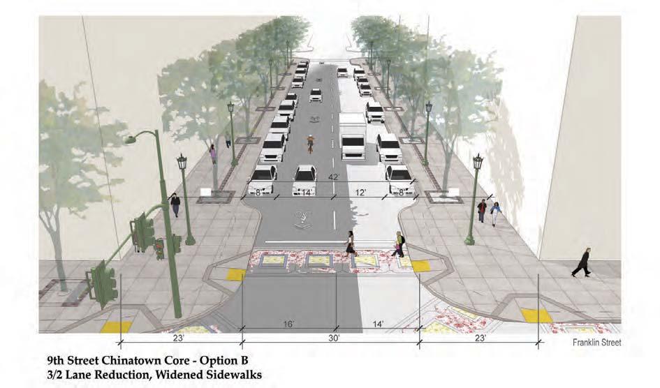
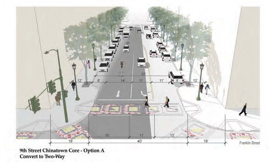
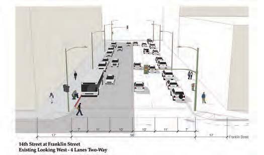
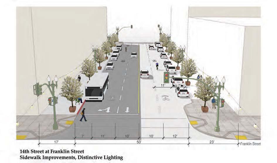
28 Lake Merritt Station Area Plan Draft Emerging Plan Analysis Report 6.4 Recommendations for Key Streets Streetscape improvement recommendations for key streets reflect the basic vision framework for the district described above, as well as current City of Oakland policies, recent study recommendations, and specific input from community members and CSG participants. Multiple improvement options are identified for a number of streets, generally those where excess roadway capacity allows for removal of more than one travel lane and/or conversion from one-way to two-way traffic without affecting adjacent streets in the roadway network. Improvements are described first for key east/west streets, proceeding from north to south, then for north/south streets, proceeding from west to east. Recommended improvements reflect the Circulation Improvement Strategies map in Chapter 7, and are illustrated with existing and proposed conditions sketches on following pages (Figure 6.3). EAST / WEST STREETS 14 th Street 14th Street is an east-west connector, linking Downtown to East Lake, and beyond. The initial concept for 14th Street includes corner bulb-outs, sharrow bikeway, sidewalk amenities including pedestrian-oriented lighting and street trees where subterranean basements and utility vaults allow; consider above-grade planter(s) with small trees where vault conditions constrain planting. Consider distinctive lighting feature(s), such as the necklace of lights, to create a strong link between the Downtown Civic Center and Lake Merritt. 10 th Street (West of Madison) 10th Street runs between Webster Street and East Oakland, changing from a one-way to twoway street at Madison Street. 10th Street has been identified as an important street for a range of pedestrian improvements, and also identified as a street with capacity for a two-way conversion or lane reduction. Several initial concepts were developed, including: Option A: Lane reduction from four lanes to three lanes and conversion from oneway to two-way (including left turn lane where needed); widened sidewalks, corner bulb-outs, sidewalk amenities including pedestrian-oriented lighting and street trees. Option B: Lane reduction from four lanes one-way to two lanes one-way; angle parking, sidewalk widening, and green street rain gardens and other features along north side; corner bulb-outs, sidewalk amenities including pedestrian-oriented lighting and street trees. Option C: Lane reduction from four lanes one-way to two lanes two-way; angle parking, sidewalk widening, and green street rain gardens and other features along north side; widened sidewalks, corner bulb-outs, sidewalk amenities including pedestrian-oriented lighting and street trees. Option D: Lane reduction from four lanes one-way to two lanes one-way; Class II bike lane; sidewalk widening, and green street rain gardens and other features 6-8
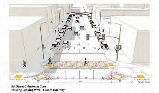
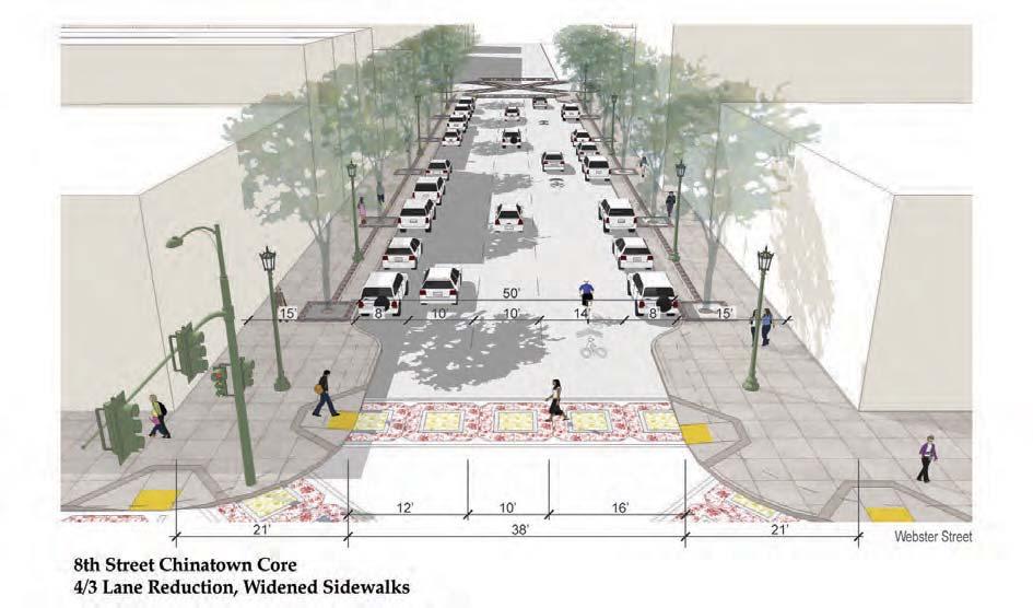
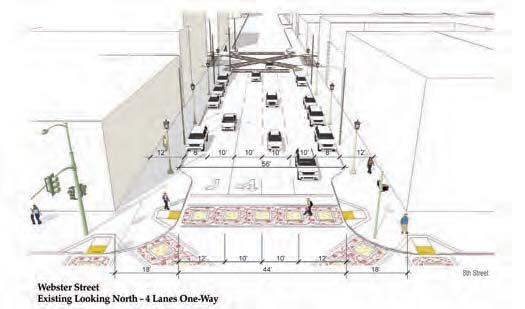
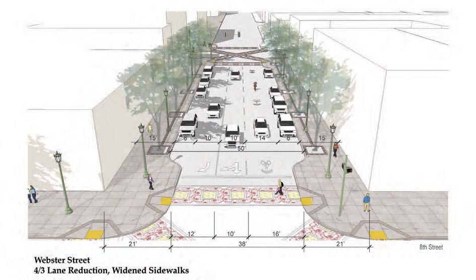
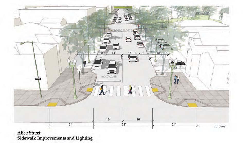
29 Lake Merritt Station Area Plan Draft Emerging Plan Analysis Report along north side; corner bulb-outs, sidewalk amenities including pedestrian-oriented lighting and street trees. 10 th Street (East of Madison) 10th Street East of Madison is a two-way low-volume street. The initial concept for 10th Street east of Madison Street includes class II bike lane; sidewalk widening, and green street rain gardens and other features along north side; corner bulb-outs, sidewalk amenities including pedestrian-oriented lighting and street trees. 9 th Street Chinatown Core/West of Harrison 9th Street is an important connecting street between the Chinatown commercial center and the Lake Merritt BART Station and was identified as a priority pedestrian connection by the community. The initial concepts for 9th Street Chinatown Core/West of Harrison include: Option A: Street conversion from three lanes one-way to three lanes two-way (including left turn lane where needed); corner bulb-outs, enhanced pedestrian crosswalks, and sidewalk amenities including pedestrian-oriented lighting and street trees. Option B: Lane reduction from three lanes one-way to two lanes one-way; sidewalk widening, corner bulb-outs, enhanced pedestrian crosswalks, and sidewalk amenities including pedestrian-oriented lighting and street trees. 9 th Street East of Harrison The initial concepts for 9th Street east of Harrison include: Option A: Street conversion from three lanes one-way to three lanes two-way (including left turn lane where needed); Class II bike lane, corner bulb-outs, enhanced pedestrian crosswalks, and sidewalk amenities including pedestrian-oriented lighting and street trees. Option B: Lane reduction from three lanes one-way to two lanes one-way; Class II bike lane, sidewalk widening, corner bulb-outs, enhanced pedestrian crosswalks, and sidewalk amenities including pedestrian-oriented lighting and street trees. 8 th Street Chinatown Core/West of Harrison 8th Street is an important connecting street between the Chinatown commercial center and the Lake Merritt BART Station and was identified as priority pedestrian connection by the community. The initial concept for 8th Street Chinatown Core/west of Harrison includes a lane reduction from four lanes one-way to three lanes one-way; sidewalk widening, corner bulb-outs, enhanced pedestrian crosswalks, and sidewalk amenities including pedestrianoriented lighting and street trees. 8 th Street East of Harrison The initial concept for 8th Street east of Harrison includes a lane reduction from four lanes one-way to three lanes one-way; Class II bike lanes; corner bulb-outs, enhanced pedestrian crosswalks, and sidewalk amenities including pedestrian-oriented lighting and street trees. 6-9
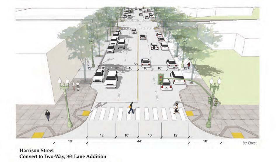
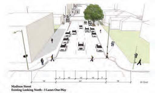
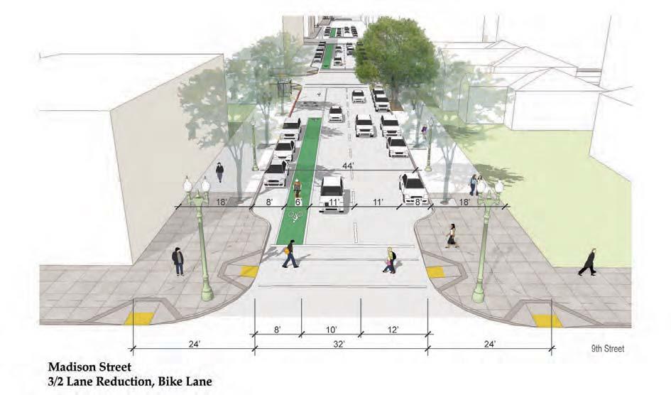
30 Lake Merritt Station Area Plan Draft Emerging Plan Analysis Report 7 th Street West of Fallon 7th Street is an important citywide east-west connector. 7th Street west of Fallon is one way eastbound. The initial concept for 7th Street west of Fallon includes corner bulb-outs, enhanced pedestrian crosswalks, and sidewalk amenities including pedestrian-oriented lighting and street trees. 7 th Street East of Fallon 7th Street is an important citywide east-west connector. 7th Street east of Fallon is a six-lane two way street that separates Laney Campus from the Laney Parking lot. The initial concept for 7th Street east of Fallon includes a reduction of three right-turn lanes to two right-turn lanes at Fallon Street intersection; expanded median island to create pedestrian crossing refuge; signalized mid-block crosswalk connecting central portion of Laney College campus and parking area; corner bulb-outs, enhanced pedestrian crosswalks. NORTH / SOUTH STREETS Webster Street Webster Street is a major north-south corridor and pedestrian street, connecting to the Webster Tube and the City of Alameda. The initial concept for Webster Street includes a lane reduction from four lanes one-way to three lanes one-way; sidewalk widening; corner bulbouts, enhanced pedestrian crosswalks, and sidewalk amenities including pedestrian-oriented lighting and street trees. Harrison Street Harrison Street is a major north-south corridor and pedestrian street, connecting to the Posey Tube and the City of Alameda. The initial concept for Harrison Street includes conversion from four lanes one-way to four lanes two-way between 10 th and 8 th Streets; corner bulb-outs, enhanced pedestrian crosswalks, and sidewalk amenities including pedestrian-oriented lighting and street trees. Alice Street Alice Street is a local street that has been identified as a key street for lighting improvements. The initial concept for Alice Street includes corner bulb-outs, enhanced pedestrian crosswalks, and sidewalk amenities including pedestrian-oriented lighting and street trees. Madison Street Madison Street is a regional north/south connector. The initial concept for Madison Street includes a lane reduction from three lanes one-way to two lanes one-way; Class II bike lane, corner bulb-outs, enhanced pedestrian crosswalks, and sidewalk amenities including pedestrian-oriented lighting and street trees. 6-10
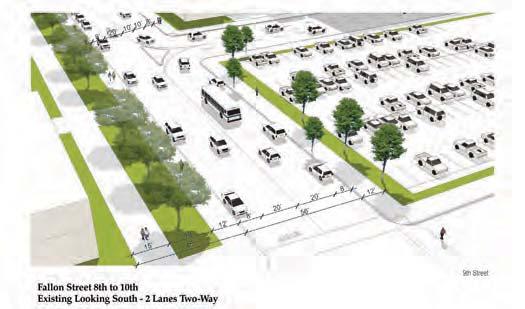
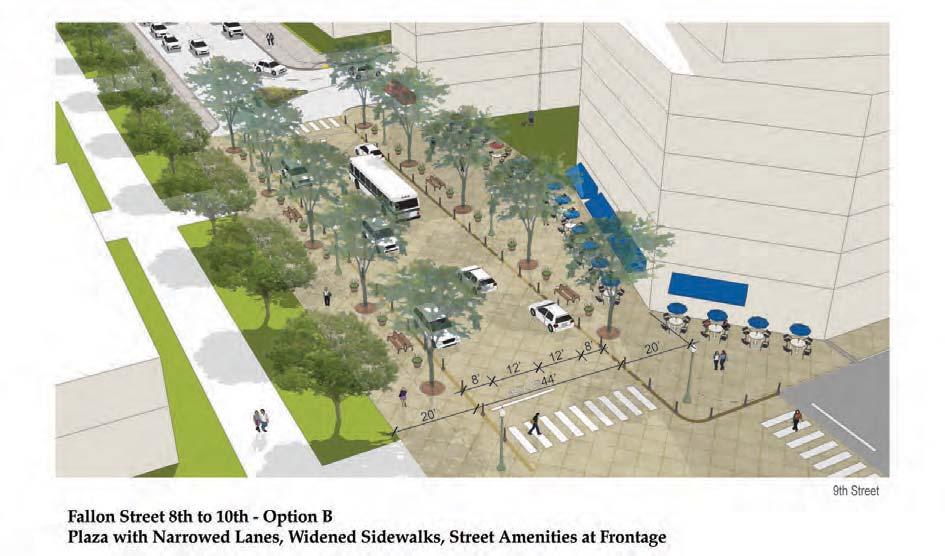
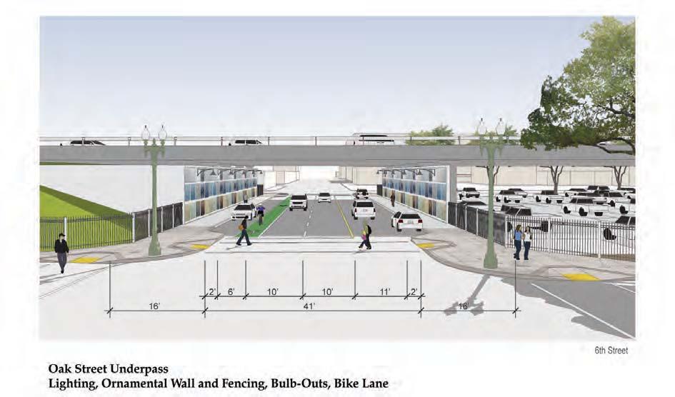
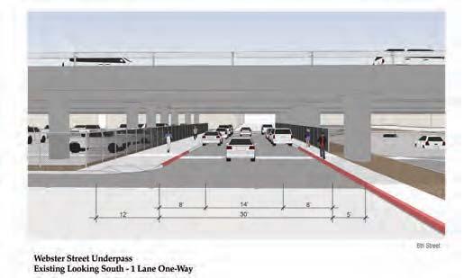
31 Lake Merritt Station Area Plan Draft Emerging Plan Analysis Report Oak Street Oak Street is a regional north/south connector. The initial concept for Oak Street includes a lane reduction from four lanes one-way to three lanes one-way; Class II bike lane; sidewalk widening north side; corner bulb-outs, enhanced pedestrian crosswalks, and sidewalk amenities including pedestrian-oriented lighting and street trees. Fallon Street (8 th to 10 th Streets) Fallon Street is a local two-way street that connects the BART Station and the entrance to Laney College. The initial concept for Fallon Street includes a street width reduction; a festival street treatment between Laney College main entrance and BART parking redevelopment site that uses traffic calming and unique streetscape features to create a street that can easily be converted to public use on weekends or special events; sidewalk widening; corner bulb-outs; enhanced pedestrian crosswalks; and sidewalk amenities including pedestrian-oriented lighting and street trees. I-880 Undercrossings Webster, Jackson, Madison, Oak Streets Improving the I-880 under-crossings is essential for connecting the Planning Area including Chinatown, Laney, and the BART Station to the Jack London District and waterfront areas. The initial concept for improving the under-crossings include an ornamental screen wall along sidewalk with integral lighting; corner bulb-outs, enhanced pedestrian crosswalks, pedestrian-oriented lighting at adjacent street corners. 6.5 Oak Street Transit Hub Primary access to the Lake Merritt BART station for automobiles and eastbound buses is provided along Oak Street. The block between 8 th and 9 th Streets should be improved as an on-street transit hub, with improved bus bays, kiss-and-ride drop-off area, and enhanced pedestrian and bicycle access and support facilities. BART patrons traveling on westbound buses would get off on 8 th Street at Oak. As depicted by the sketch in Figure 6.4, existing onstreet parking would be removed along the easterly frontage to create a bus-only transfer area, and parking along the westerly frontage would be programmed for kiss-and-ride drop-off and pick-up during peak commute hours. Substantial corner bulb-outs shorten pedestrian crossing distances and help define the transit hub as a special street segment. In this block, the bike lane planned north and south would continue through with dashed striping. The Transit Hub sketch also depicts general improvements to plaza areas on adjacent redevelopment sites. On the west side of Oak Street, planting areas are reconfigured to provide more visibility and pedestrian circulation adjacent to BART station escalator entries. On the east, the large existing concrete shelter structure is replaced with smaller, more contemporary architectural glass structures to allow more space for pedestrian circulation and provides a landmark for the transit hub area as a whole. A key card-accessed bicycle corral is depicted near planned new development on the adjacent BART parking site at 9 th Street. More open, corner café-oriented spaces are depicted adjacent to the proposed retail corners at 8 th and 9 th Streets. 6-11


32 Figure 6.3: STREETSCAPE CONCEPTS FIGURES 57


33 58 DRAFT EMERGING PLAN ANALYSIS REPORT

34 Figure 6.3 Continued: STREETSCAPE CONCEPTS FIGURES 59


35 60 DRAFT EMERGING PLAN ANALYSIS REPORT

36 Figure 6.3 Continued: STREETSCAPE CONCEPTS FIGURES 61
37 62 DRAFT EMERGING PLAN ANALYSIS REPORT

38 Figure 6.3 Continued: STREETSCAPE CONCEPTS FIGURES 63

39 Figure 6.3 Continued: STREETSCAPE CONCEPTS 64 DRAFT EMERGING PLAN ANALYSIS REPORT

40 Figure 6.3 Continued: STREETSCAPE CONCEPTS FIGURES 65


41 66 DRAFT EMERGING PLAN ANALYSIS REPORT

42 Figure 6.3 Continued: STREETSCAPE CONCEPTS FIGURES 67


43 Figure 6.4: OAK STREET TRANSIT HUB 68 DRAFT EMERGING PLAN ANALYSIS REPORT
Bicycle and Pedestrian Advisory Committee (BPAC) November 21, 2013
 November 21, 2013") Bicycle and Pedestrian Advisory Committee (BPAC) November 21, 2013 OVERALL LAND USE CONCEPT Overall Broadway Valdez District: 95.5 acres (35.1 acres right-of ways + 60.4 acres developable land) Plan Subareas:
Bicycle and Pedestrian Advisory Committee (BPAC) November 21, 2013 OVERALL LAND USE CONCEPT Overall Broadway Valdez District: 95.5 acres (35.1 acres right-of ways + 60.4 acres developable land) Plan Subareas:
Executive Summary Route 30 Corridor Master Plan
 Route Corridor Master Plan Project Overview The Route Corridor Master Plan is a coordinated multimodal transportation and land use plan for the entire stretch of Route through East Whiteland Township,
Streetscape: Core Shopping District
 Streetscape: Core Shopping District DRAFT DRAFT DRAFT May 00 Core Shopping District: Phase Blue Island s Core Shopping District is located along Western Avenue, between Grove and Union Streets. Streetscape
San Jose Transportation Policy
 San Jose Transportation Policy Protected Intersections in LOS Policies to Support Smart Growth Presented by: Manuel Pineda City of San Jose Department of Transportation Bay Area Map San Francisco Oakland
Vision: Traditional hamlet with an attractive business/pedestrian friendly main street connected to adjacent walkable neighborhoods
 N D. Focus Area II Vision: Traditional hamlet with an attractive business/pedestrian friendly main street connected to adjacent walkable neighborhoods Transit Road Focus Area II is located in the Hamlet
7 Circulation, Access, and Parking
 7 Circulation, Access, and Parking The Lake Merritt Station Planning Area provides local residents, employers and employees, students, and visitors access to a broad range of transportation options, including
City of Novi Non-Motorized Master Plan 2011 Executive Summary
 City of Novi Non-Motorized Master Plan 2011 Executive Summary Prepared by: February 28, 2011 Why Plan? Encouraging healthy, active lifestyles through pathway and sidewalk connectivity has been a focus
CITY OF BLOOMINGTON COMPLETE STREETS POLICY
 CITY OF BLOOMINGTON COMPLETE STREETS POLICY POLICY OBJECTIVE: The City of Bloomington will enhance safety, mobility, accessibility and convenience for transportation network users of all ages and abilities,
Solana Beach Comprehensive Active Transportation Strategy (CATS)
") Solana Beach Comprehensive Active Transportation Strategy (CATS) 3.0 Goals & Policies The Solana Beach CATS goals and objectives outlined below were largely drawn from the Solana Beach Circulation Element
Solana Beach Comprehensive Active Transportation Strategy (CATS) 3.0 Goals & Policies The Solana Beach CATS goals and objectives outlined below were largely drawn from the Solana Beach Circulation Element
Obey Creek PEDESTRIAN CIRCULATION EAST WEST PARTNERS PEDESTRIAN CIRCULATION CREEK SIDE LANE SLIP STREET SCOTT MURRAY MAIN STREETS EAST/WEST
 THE VILLAGE AT PEDESTRIAN CIRCULATION MAIN STREETS NORTH/SOUTH MAIN STREETS EAST/WEST SLIP STREET CREEK SIDE LANE PEDESTRIAN CIRCULATION DESCRIPTION: Circulation through the downtown of is organized by
Living Streets Policy
 Living Streets Policy Introduction Living streets balance the needs of motorists, bicyclists, pedestrians and transit riders in ways that promote safety and convenience, enhance community identity, create
Bicycle Master Plan Goals, Strategies, and Policies
 Bicycle Master Plan Goals, Strategies, and Policies Mobilizing 5 This chapter outlines the overarching goals, action statements, and action items Long Beach will take in order to achieve its vision of
A CHANGING CITY. of Edmonton, it is essential that it reflects the long-term vision of the City.
 A CHANGING CITY By the year 2040, Edmonton will be home to more than 1 million people. To accommodate growth and support a healthy and compact city, we need a new approach to development/redevelopment
5 CIRCULATION AND STREET DESIGN
 5 CIRCULATION AND STREET DESIGN This chapter describes circulation and streetscape improvements proposed for the Northwest Chico Specific Plan Area. It includes detailed design specifications for existing
Proposed. City of Grand Junction Complete Streets Policy. Exhibit 10
 Proposed City of Grand Junction Complete Streets Policy Exhibit 10 1 City of Grand Junction Complete Streets Policy Vision: The Complete Streets Vision is to develop a safe, efficient, and reliable travel
CONNECTING PEOPLE TO PLACES
 CONNECTING PEOPLE TO PLACES 82 EAST BENCH MASTER PLAN 07 Introduction The East Bench transportation system is a collection of slow moving, treelined residential streets and major arteries that are the
12/4/2016 VIA . RE: Grocery Outlet Del Paso (DR16-328)
") 12/4/2016 VIA EMAIL Ethan Meltzer, Assistant Planner City of Sacramento Community Development Department 300 Richards Blvd, 3 rd Floor Sacramento, CA 95811 RE: Grocery Outlet Del Paso (DR16-328) Dear Mr.
12/4/2016 VIA EMAIL Ethan Meltzer, Assistant Planner City of Sacramento Community Development Department 300 Richards Blvd, 3 rd Floor Sacramento, CA 95811 RE: Grocery Outlet Del Paso (DR16-328) Dear Mr.
Berkeley Strategic Transportation Plan A-76
 Berkeley Strategic Transportation Plan A-76 Appendices 1. A Team Effort 2. Where We ve Been A-11 Berkeley Strategic Transportation Plan Alameda County Transportation Plan Alameda County will be served
o n - m o t o r i z e d transportation is an overlooked element that can greatly enhance the overall quality of life for the community s residents.
 N o n - m o t o r i z e d transportation is an overlooked element that can greatly enhance the overall quality of life for the community s residents. 84 Transportation CHAPTER 11 INTRODUCTION Transportation
Exhibit 1 PLANNING COMMISSION AGENDA ITEM
 Exhibit 1 PLANNING COMMISSION AGENDA ITEM Project Name: Grand Junction Circulation Plan Grand Junction Complete Streets Policy Applicant: City of Grand Junction Representative: David Thornton Address:
Perryville TOD and Greenway Plan
 Perryville TOD and Greenway Plan Greenway Glossary Pathway: A bicycle and pedestrian path separated from motorized vehicular traffic by an open space, barrier or curb. Multi-use paths may be within the
Table #6 VISION CHARACTERISTICS
 Table #6 VISION White Flint is a place to live, work, play, shop, and walk with sufficient density to encourage quality redevelopment. Vibrant streets and consistent streetscapes are important. CHARACTERISTICS
PEDESTRIAN ACTION PLAN
 ATTACHMENT 2 CITY OF SANTA MONICA PEDESTRIAN ACTION PLAN CITY OF SANTA MONICA PEDESTRIAN ACTION PLAN This page intentionally left blank EXECUTIVE SUMMARY CHAPTER 1 EXECUTIVE SUMMARY Setting the Stage
WELCOME. Purpose of the Open House. Update you on the project. Present a draft recommended plan. Receive your input
 WELCOME Purpose of the Open House The Town of Smiths Falls has initiated the Beckwith Street Redevelopment Plan that includes the preparation of a streetscape functional design for the renewal of Beckwith
Corpus Christi Metropolitan Transportation Plan Fiscal Year Introduction:
 Introduction: The Safe, Accountable, Flexible, Efficient Transportation Equity Act: A Legacy for Users (SAFETEA-LU) has continued the efforts started through the Intermodal Surface Transportation Efficiency
APPENDIX A: Complete Streets Checklist DRAFT NOVEMBER 2016
 APPENDIX A: Complete Streets Checklist DRAFT NOVEMBER 2016 Complete Streets Checklist MetroPlan Orlando s Complete Streets Checklist is an internal planning tool for staff to further implementation of
Ann Arbor Downtown Street Plan
 1 Ann Arbor Downtown Street Plan Public Workshop #1 We know that. 2 Public right-of-way (streets, sidewalks, and alleys) make up 30% of the total District area of downtown. Streets need to provide mobility
Chapter 3: Multi-Modal Circulation and Streetscapes
 CHAPTER 3: MULTI-MODAL CIRCULATION AND STREETSCAPES Chapter 3: Multi-Modal Circulation and Streetscapes Overview Streetscape improvements have already been completed for Depot Street between Main Avenue
2.0 Existing Conditions
 20 2.0 Existing Conditions 2.1 Land Use, Future Growth Patterns, Physical Barriers Geographic Overview Sutter County s land use pattern is characterized by extensive agricultural areas, significant natural
Fitting Light Rail through Well-established Communities
 Fitting Light Rail through Well-established Communities San Francisco 2008 Michael D. Madden Chief, Project Development, Maryland Transit Administration Project Setting Located inside the Capital Beltway
7/23/2017 VIA . Michael Hanebutt City of Sacramento Community Development Department 300 Richards Boulevard, 3 rd Floor Sacramento, CA 95811
 7/23/2017 VIA EMAIL Michael Hanebutt City of Sacramento Community Development Department 300 Richards Boulevard, 3 rd Floor Sacramento, CA 95811 RE: 65 th Street Apartments (DR17-220) Dear Mr. Hanebutt:
Circulation in Elk Grove includes: Motor vehicles, including cars and trucks
 Circulation, as it is used in this General Plan, refers to the many ways people and goods move from place to place in Elk Grove and the region. Circulation in Elk Grove includes: Motor vehicles, including
Tonight is for you. Learn everything you can. Share all your ideas.
 Strathcona Neighbourhood Renewal Draft Concept Design Tonight is for you. Learn everything you can. Share all your ideas. What is Neighbourhood Renewal? Creating a design with you for your neighbourhood.
Illustrated Principles of Good Planning
 Illustrated Principles of Good Planning The Miami 21 Zoning Code incorporates time-tested planning principles into the zoning regulations of our City. These are principles that make for better neighborhoods,
Arapahoe Square Zoning + Design Standards & Guidelines Task Force Meeting 9 January 27, 2016
 Arapahoe Square Zoning + Design Standards & Guidelines Task Force Meeting 9 January 27, 2016 Agenda 3:00 Opening/Welcome 3:15 Touch Base on Schedule and Milestones Moving Forward 3:20 Review the Overall
ATTACHMENT 4 - TDM Checklist. TDM Checklist Overview
 ATTACHMENT 4 - TDM Checklist TDM Checklist Overview The proposed checklist rates developments on the degree to which they are TDM and transit supportive. Points are assigned based on the level of transit
HARRISON STREET/OAKLAND AVENUE COMMUNITY TRANSPORTATION PLAN
 HARRISON STREET/OAKLAND AVENUE Community Workshop #4: Draft Plan Review December 3, 2009 D E S I G N, C O M M U N I T Y & E N V I R O N M E N T INTRODUCTIONS Key Project Staff: Alisa Shen, Project Manager,
Stakeholder Meeting Handouts. January 2013
 January 2013 Stakeholder Meeting Handouts The Case FOR Parking Minimum Requirements Reduce street congestion around the development site Avoid parking spillover Create orderly development patterns Anticipate
5/7/2013 VIA . RE: University Village Safeway Expansion (P13-019)
") 5/7/2013 VIA EMAIL David Hung, Associate Planner Community Development Department, Current Planning Division City of Sacramento 300 Richards Boulevard, 3 rd Floor Sacramento, CA 95811 RE: University Village
5/7/2013 VIA EMAIL David Hung, Associate Planner Community Development Department, Current Planning Division City of Sacramento 300 Richards Boulevard, 3 rd Floor Sacramento, CA 95811 RE: University Village
NJDOT Complete Streets Checklist
 Background The New Jersey Department of Transportation s Complete Streets Policy promotes a comprehensive, integrated, connected multi-modal network by providing connections to bicycling and walking trip
City of Walnut Creek TELEGRAPH AVENUE BART LINE SELF-GUIDED TOD TOUR 19TH STREET BART STATION
 TELEGRAPH AVENUE City of Walnut Creek BART LINE SELF-GUIDED TOD TOUR 19TH STREET BART STATION Self-Guided TOD Tour With the Walnut Creek BART Station located squarely within its boundaries, the West Downtown
TRANSPORTATION NEEDS ASSESSMENT
 TRANSPORTATION NEEDS ASSESSMENT A travel demand analysis was carried out to determine the operational issues and the potential benefit that adding traffic capacity would have on the road network. All the
TRAVEL PLAN: CENTRAL EUROPEAN UNIVERSITY CAMPUS REDEVELOPMENT PROJECT TRAVEL PLAN. Central European University Campus Redevelopment Project.
 TRAVEL PLAN Central European University Campus Redevelopment Project Page 1 Table of Contents Introduction... 3 Background... 7 Building Users... 7 Transportation in Community Consultation... 7 Summary
PUBLIC REALM MASTER PLAN
 WESTSHORE BUSINESS DISTRICT PUBLIC REALM MASTER PLAN MASTER PLAN COMMITTEE MEETING MARCH 20, 2013 WESTSHORE BUSINESS DISTRCT PUBLIC REALM MASTER PLAN MACRO-SCALE CONCEPT: A PUBLIC REALM FRAMEWORK DEFINED
PEDESTRIAN CIRCULATION & STREETSCAPE DESIGN
 CHAPTER 4 Chapter 4 Pedestrian Circulation & Trails PEDESTRIAN CIRCULATION & STREETSCAPE DESIGN In recent years, the City has constructed new sidewalks and enhanced existing ones in the downtown with brick
CASE STUDY WALKABLE WASHINGTON WHO WE ARE & WHAT WE DO CITY OF BOTHELL DOWNTOWN REVITALIZATION PLAN BOTHELL, WA
 LKABLE SHNGTON Transformation towards walkability is taking place all over the state of Washington. From urban, suburban and small town initiatives, the program showcases the effects of a renewed focus
MARTIN LUTHER KING JR. WAY
 OCTOBER 2011 40 Vision and Goals The Martin Luther King, Jr. Way Illustrative Master Plan that follows has been developed through a process of community involvement. It expresses a long term vision for
4 MOBILITY PLAN. Mobility Plan Objectives. Mobility Context. 1. Integrate with Local and Regional Transit Improvements
 Harbor Mixed Use CHAPTER Transit Corridor 4: Mobility Plan 4 MOBILITY PLAN Mobility Plan Objectives The Harbor Corridor Plan seeks to expand and improve the ways that people move along and through the
summary of issues and opportunities
 1 summary of issues and opportunities EXECUTIVE SUMMARY CHAPTER 2: HISTORY - 3: LAND USE This first chapter is an overview of lessons learned from analysis of the existing conditions on El Camino as well
CURBSIDE ACTIVITY DESIGN
 5 CURBSIDE ACTIVITY DESIGN This chapter provides design guidance for separated bike lanes adjacent to curbside activities including parking, loading and bus stops. Typical configurations are presented
Chapter 7. Transportation. Transportation Road Network Plan Transit Cyclists Pedestrians Multi-Use and Equestrian Trails
 Chapter 7 Transportation Transportation Road Network Plan Transit Cyclists Pedestrians Multi-Use and Equestrian Trails 7.1 TRANSPORTATION BACKGROUND The District of Maple Ridge faces a number of unique
S T A T I O N A R E A P L A N
 The Circulation and Access Plan describes vehicle, pedestrian, and transit improvements recommended within the Concept Plan. In order to create and sustain a vibrant business district that provides pedestrian-friendly
Omaha s Complete Streets Policy
 Omaha s Complete Streets Policy (Adopted August 2015) VISION To create great places and enhance our quality of life, the City of Omaha will provide safe, accessible streets for all users. Complete Streets
Chapter 5 Future Transportation
 Chapter 5 Future Transportation The Future Land Use Plan identifies the desired land use designations. The land uses desired for Crozet depend, in large part, on the success of the transportation system,
TRANSPORTATION COMMISSION Agenda Staff Report
 TRANSPORTATION COMMISSION Agenda Staff Report Agenda Item No. 5.a DATE: JULY 31, 2014 TO: FROM: SUBJECT: TRANSPORTATION COMMISSION COMMUNITY DEVELOPMENT DEPARTMENT - PLANNING DRAFT OLYMPIC CORRIDOR PREFERRED
CITY OF SEATTLE RESOLUTION. WHEREAS, the Washington State Department of Transportation (WSDOT) led the Seattle
 led the Seattle") SDOT SR0 Design Refinements RES August, 0 Version #D 0 CITY OF SEATTLE RESOLUTION..title A RESOLUTION relating to the State Route 0, Interstate to Medina Bridge Replacement and High Occupancy Vehicle Project;
SDOT SR0 Design Refinements RES August, 0 Version #D 0 CITY OF SEATTLE RESOLUTION..title A RESOLUTION relating to the State Route 0, Interstate to Medina Bridge Replacement and High Occupancy Vehicle Project;
Thesis Presentation. Moorhead City Walk: A Master Plan to Reimage Moorhead, Minnesota s Urban Core. Brad Garcia Advisors: Jason Kost & Dominic Fischer
 Thesis Presentation Moorhead City Walk: A Master Plan to Reimage Moorhead, Minnesota s Urban Core Brad Garcia Advisors: Jason Kost & Dominic Fischer MOORHEAD, MN Red River Center Ave 8 TH St N FARGO, ND
Welcome. Background. Goals. Vision
 Welcome The formal Public Information Centre (PIC) for the Transportation Master Plan How We GO will be held in early 2017. At that time we will present the recommended transportation system for Niagara
CITY OF COCOA BEACH 2025 COMPREHENSIVE PLAN. Section VIII Mobility Element Goals, Objectives, and Policies
 CITY OF COCOA BEACH 2025 COMPREHENSIVE PLAN Section VIII Mobility Element Goals, Objectives, and Policies Adopted August 6, 2015 by Ordinance No. 1591 VIII MOBILITY ELEMENT Table of Contents Page Number
Transportation Master Plan Advisory Task Force
 Transportation Master Plan Advisory Task Force Network Alternatives & Phasing Strategy February 2016 BACKGROUND Table of Contents BACKGROUND Purpose & Introduction 2 Linking the TMP to Key Council Approved
complete streets design and construction standards public primer City of Edmonton
 complete streets design and construction standards public primer City of Edmonton introduction Complete Streets are streets for everyone: people who walk, wheel, bike, take transit, or drive. They are
STEERING COMMITTEE MEETING June 17, Streetscape Overview Burlington Comprehensive Master Plan
 STEERING COMMITTEE MEETING June 17, 2015 Streetscape Overview Burlington Comprehensive Master Plan 1 Introduction Slide This slide show was presented to the Burlington Steering Committee on June 17, 2015
Outreach Approach RENEW SF served as the primary liaison with the North Beach community; the Chinatown. Executive Summary
 Executive Summary Executive Summary The Columbus Avenue Neighborhood Transportation Study s objective is to identify changes to transportation infrastructure and policies that could enhance the livability
RESOLUTION NO ?? A RESOLUTION OF THE CITY OF NEPTUNE BEACH ADOPTING A COMPLETE STREETS POLICY
 RESOLUTION NO. 2018-?? A RESOLUTION OF THE CITY OF NEPTUNE BEACH ADOPTING A COMPLETE STREETS POLICY WHEREAS, safe, convenient, and accessible transportation for all users is a priority of the City of Neptune
Public Workshop #2. September 14, 2016
 Public Workshop #2 September 14, 2016 Agenda Welcome Project Overview Where We Have Been Alternatives for State Street Land Use Street Design Next Steps 2 Project Overview Create a Vibrant State Street
CONNECTIVITY PLAN. Adopted December 5, 2017 City of Virginia Beach
 CONNECTIVITY PLAN Adopted December 5, 2017 City of Virginia Beach CONTENTS 1.0 Background & Purpose... 2 2.0 Existing Inventory & Analysis... 3 ViBe District Existing Walking Conditions... 4 3.0 ViBe District
5 Circulation & Parking
 5 Circulation & Parking Downtown Parking & Circulation Strategy. Downtown Wayne has a somewhat disconnected system of local public streets to connect downtown with the residential neighborhoods, and primary
5/31/2016 VIA . Arwen Wacht City of Sacramento Community Development Department 300 Richards Blvd., 3 rd Floor Sacramento, CA 95811
 5/31/2016 VIA EMAIL Arwen Wacht City of Sacramento Community Development Department 300 Richards Blvd., 3 rd Floor Sacramento, CA 95811 RE: El Pollo Loco (P16-028) Dear Ms. Wacht: WALKSacramento has reviewed
NEWMARKET UPHAM S CORNER
 SOUTH STATION Planning Initiative NEWMARKET UPHAM S CORNER COLUMBIA ROAD (P) FOUR CORNERS/GENEVA Working Advisory Group (WAG) Meeting #5 TALBOT AVENUE MORTON STREET BLUE HILL AVE/CUMMINS HWY (P) RIVER
Comments The Plan for Port Whitby
 Comments The Plan for Port Whitby April 24th, 2013 Community Meeting #2 Summary Report Prepared by GLPi April 29th, 2013 1 Introduction The purpose of the Port Whitby Secondary Plan Update, Community Improvement
STONY PLAIN ROAD STREETSCAPE
 Jasper Place Revitalization Strategy: Vision The people involved in the Jasper Place Revitalization Strategy envision: Goal 1: Feeling safe in our community Create a community where feeling safe is common--where
Lincoln Neighborhood Corridor Plan The LiNC
 CITY OF SANTA MONICA Lincoln Neighborhood Corridor Plan The LiNC PLANNING COMMISSION September 2, 2015 COMMUNITY DESIGN + ARCHITECTURE TEAM: Community Design + Architecture Iteris Studio 111 Urban Place
CHAPTER 7.0 IMPLEMENTATION
 CHAPTER 7.0 IMPLEMENTATION Achieving the vision of the Better Streets Plan will rely on the ability to effectively fund, build and maintain improvements, and to sustain improvements over time. CHAPTER
Item to be Addressed Checklist Consideration YES NO N/A Required Description Complete Streets Guidelines
 Passaic County Complete Streets Checklist - Concept Development Project Name Item to be Addressed Checklist Consideration YES NO N/A Required Description Complete Streets Guidelines Existing Plans Have
EXECUTIVE SUMMARY. Vision
 Vision Walking and bicycling in Salt Lake City will be safe, convenient, comfortable, and viable transportation options that connect people to places, foster recreational and economic development opportunities,
Mainstreet Master Plan Land Use
 Mainstreet Master Plan 04 Land Use Top Recommendations Active Uses: Promote active ground-floor uses such as retail, restaurants, galleries and personal services with interactive storefronts for Mainstreet
Complete Streets. Designing Streets for Everyone. Sarnia
 Complete Streets Designing Streets for Everyone Sarnia Complete Streets ~ Sarnia ~ 2018 Introduction Our City is made up of a network of streets that we use to go for a walk, cycle to work, drive to the
JOINT PARTNERSHIPS: Working Together To Support Light Rail in Santa Monica
 JOINT PARTNERSHIPS: Working Together To Support Light Rail in Santa Monica ITY OF ANTA MONICA RAIL-VOLUTION / OCTOBER 17, 2012 SARAH LEJEUNE, PRINCIPAL PLANNER, STRATEGIC + TRANSPORTATION PLANNING DIVISION
Douglas Land Use and Transportation Strategy (DLUTS) Summary. August 2013
 Summary. August 2013") Douglas Land Use and Transportation Strategy (DLUTS) Summary August 2013 Background Douglas is a large and popular residential suburb of approximately 30,000 persons on the periphery of Cork City along
Douglas Land Use and Transportation Strategy (DLUTS) Summary August 2013 Background Douglas is a large and popular residential suburb of approximately 30,000 persons on the periphery of Cork City along
DRAFT. Table of Contents. Background
 Douglas County Table of Contents Existing Infrastructure 86 Funding 89 Policy and Program Recommendations 90 Infrastructure Recommendations 92 Conclusion 95 Background Home to 4,500 residents and Baker
Purpose and Need. Chapter Introduction. 2.2 Project Purpose and Need Project Purpose Project Need
 Chapter 2 Purpose and Need 2.1 Introduction The El Camino Real Bus Rapid Transit (BRT) Project (Project) would make transit and other transportation improvements along a 17.6-mile segment of the El Camino
Community Meeting February 27, 2007 Dorchester Avenue Transportation & Streetscape Improvements Action Plan February 27, 2007
 Community Meeting Tonight s Agenda 6:00 Introductions South Boston/Dot Ave Improvement Study Background 6:15 Consultant Introductions Review of Scope and Schedule Review of Proposed Corridor Wide Guidelines
APPROVE A RESOLUTION ADOPTING A COMPLETE STREETS POLICY
 STAFF REPORT MEETING DATE: September 13, 2016 TO: FROM: City Council Bob Brown, Community Development Director Russ Thompson, Public Works Director Patrick Filipelli, Management Analyst 922 Machin Avenue
Richmond Connects Visioning Update
 Richmond Connects Visioning Update To date there have been four elements of the visioning process: Vision20 Night at Byrd Theatre on May 3rd Advisory Committee Meeting on May 12 th Public Visioning Workshop
Chapter VISION, MISSION, AND GOALS AND OBJECTIVES. Vision. Mission. Goals and Objectives CONNECTING COMMUNITIES ACROSS THE ST.
 VISION, MISSION, AND GOALS AND OBJECTIVES Chapter 3 The Plan s vision, mission, and goals and objectives were developed through a series of interactive exercises with the Citizens Advisory Committee (CAC)
4. ENVIRONMENTAL IMPACT ANALYSIS 9. TRANSPORTATION AND TRAFFIC
 4. ENVIRONMENTAL IMPACT ANALYSIS 9. TRANSPORTATION AND TRAFFIC 4.9.1 INTRODUCTION The following section addresses the Proposed Project s impact on transportation and traffic based on the Traffic Study
HOOPA DESIGN FAIR 4. IMPLEMENTATION PHASES & FUNDING
 4. IMPLEMENTATION PHASES & FUNDING HOOPA DESIGN FAIR 4-1 4. IMPLEMENTATION PHASES & FUNDING Phase One Development 1. Implementation The Conceptual Plan recommends five concept elements to revitalize downtown
East Burke Transportation, Safety and Capacity Improvements
 East Burke Transportation, Safety and Capacity Improvements The purpose of this project is to increase mobility and improve safety for pedestrians, cyclists, and motor vehicles along VT Route 114 in the
Active Transportation Infrastructure Investment A Business Case
 Active Transportation Infrastructure Investment A Business Case In 2016, the Real Estate Foundation awarded the Capital Regional District a $50,000 grant for Shifting Gears: Land Use Change through Active
Classification Criteria
 SCHEDULE D TO RECOMMENDED OFFICIAL PLAN AMENDMENT NO. 40 SCHEDULE C-4 Road Criteria Criteria Traffic Service Objective Land Service/Access Typical Daily Traffic Volume Flow characteristics Travel Speed
FINAL REPORT DECEMBER 2011
 FINAL REPORT DECEMBER 2011 AKNOWLEDGEMENTS SFMTA Staff Erin Miller, Project Manager Timothy Papandreou Jerry Robbins Pamela Stone Mike Sallaberry Chris Dimeling Emily Drennen Suzanne Chen-Harding San
Observations and Ideas: Toomer s Corner Streetscape Improvements
 Observations and Ideas: Toomer s Corner Streetscape Improvements AUBURN DOWNTOWN MASTER PLAN planning downtown s future August 26, 2013 Observations: Vertical Clutter at Corners 6 3 7 5 9 2 8 4 1 Excess
DRAFT for a State Policy for Healthy Spaces and Places
 DRAFT for a State Policy for Healthy Spaces and Places 1 DRAFT State Policy for Healthy spaces and Places 1. Purpose To encourage the use and development of land that builds healthy communities through
Vision. cultural identity, income group, neighborhood identity, or mobility level. Rendering by Robin Chiang
 Vision Rendering by Robin Chiang The will result in a street system designed to promote human needs for the use and enjoyment of these public spaces by all. It will prioritize the needs of walking, bicycling,
5. Automobile Circulation, Wayfinding and Signage
 5. Automobile Circulation, Wayfinding and Signage Policy: The City Center should have a balanced, safe, and interconnected circulation system that provides expanded travel opportunities for transit, pedestrian,
EXECUTIVE SUMMARY: TRANSIT-ORIENTED DEVELOPMENT IN SMITHS FALLS, ONTARIO; A COMPARISON BETWEEN TWO SITES
 EECUTIVE SUMMARY: TRANSIT-ORIENTED DEVELOPMENT IN SMITHS FALLS, ONTARIO; A COMPARISON BETWEEN TWO SITES Topic and Purpose In 2007, the Mayor of Ottawa s Task Force on Transportation suggested adding a
Chapter 2. Bellingham Bicycle Master Plan Chapter 2: Policies and Actions
 Chapter 2 Bellingham Bicycle Master Plan Chapter 2: Policies and Actions Chapter 2: Policies and Actions The Bicycle Master Plan provides a road map for making bicycling in Bellingham a viable transportation
Mission-Geneva Transportation Study Community Workshop 2 July 8, 2006
 Community Workshop 2 July 8, 2006 Small Group Workbook 1 Basic Improvements on Mission Street Streetscape. Pedestrian-scale lighting; landscaping; community art on utility boxes; more (possibly unique)
Montford Drive Parking & Circulation Study
 Montford Drive Parking & Circulation Study Parking & Circulation Study Follow up to the Area Plan based on what we heard Purpose 1 2 3 4 To look closer and evaluate parking and network related issues (including
PEDALING FORWARD. A Glance at the SFMTA s Bike Program for SFMTA.COM
 PEDALING FORWARD A Glance at the SFMTA s Bike Program for 2017-2021 SFMTA.COM INTRODUCTION About This Booklet More people from all walks of life see their bicycle as a more convenient way to get where