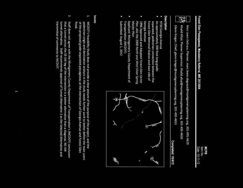
Comments EXECUTIVE SUMMARY
|
|
|
- Tamsyn Pope
- 6 years ago
- Views:
Transcription
1
2 Comments 1. Under any Alternatives, MCDOT should provide better at-grade pedestrian crossing of Georgia Avenue and Forest Glen Road, including improved crosswalks with wider medians and adequate signal time for pedestrians. 2. MCDOT should explore potential at-grade improvements, separately or in conjunction with the Maryland State Highway Administration s (MDSHA) Georgia Avenue Project Planning Study for the stretch of Georgia Avenue between 16 th Street and Forest Glen Road. 3. If at-grade upgrades are not possible, the Tunnel Alternative 2 (NE-SW) should be selected. 4. Per the Sector Plan, a sidewalk on the north side of Forest Glen Road should be constructed from the terminus of the Tunnel Alternative 2 to Dameron Drive and Holy Cross Hospital. 5. This Mandatory Referral review covers the alternative selection only. A separate Mandatory Referral for the project design of the selected alternative must be submitted for the Planning Board review during the facility planning stage. EXECUTIVE SUMMARY The MCDOT is proposing a pedestrian tunnel crossing of Georgia Avenue at Forest Glen Road (MD 192). Out of an initial group of six grade-separated alternatives, the MCDOT selected three alternatives and conducted a Feasibility Study to select a final alternative, Tunnel Alternative 1, across Georgia Avenue at the southern leg of the intersection. The segment of Georgia Avenue between 16 th Street and Forest Glen Road presents many pedestrian challenges. According to the Feasibility Study, this segment of Georgia Avenue between the I 495 off ramp to the south and Tilton Drive to the north (which includes the Forest Glen Road intersection) had nearly four times as many pedestrian related accidents as the statewide average for similar roadways. The total crash rate (all types combined) was 468 per 100 million vehicle miles traveled, which is more than twice the statewide average. Planning Staff s main concern is that the Study provided neither a clear rationale for a grade-separated crossing of the intersection, nor a full description of pedestrian activity at the intersection. Although the Study conducted four separate pedestrian surveys/counts at the intersection, it still did not provide a comprehensive picture of the issue of pedestrian safety and crossing of the intersection to access the Metro Station. Specifically, the study failed to define who the main users of the grade-separated interchange were going to be (community or the hospital users), and therefore which alternative would best serve their need for safely accessing the Forest Glen Metrorail Station. Without this information it is difficult to determine which at-grade, or grade-separated crossing would best improve pedestrian safety at this location. The submitted material also presented conflicting information regarding the purpose of the proposed project. MCDOT applied for two TIGER Grants through the United States Department of Transportation (USDOT) for funding for the Tunnel Alternative 1 (SE-SW). In both of these applications, MCDOT stated that the rationale for constructing the Passageway was to create a safer linkage from the Forest Glen Metrorail station to Holy Cross Hospital, particularly for users of mobility devices. This rationale was not included in the Feasibility Study, making it unclear what the objective of the Passageway is, and what measures should be used to improve pedestrian safety and how they should be evaluated. 2
3 Planning Staff s review of the proposed project and the submitted material indicates that the Feasibility Study did not address the full range of options to improve pedestrian safety for those crossing both Georgia Avenue and Forest Glen Road. MCDOT considered six grade-separated crossings of Georgia Avenue at Forest Glen Road, but did not evaluate at-grade improvements and what impact they would have on pedestrian safety. And the Study did not establish a set of standards on which to evaluate how best to improve pedestrian safety. Although Planning Staff is recommending Alternative 2 (NE-SW) based on the submitted Mandatory Referral, Staff believes that the project needs further evaluation before committing significant resources to this initiative. One option is to explore at-grade improvements as part of the ongoing MDSHA Georgia Avenue Project Planning Study, which will analyze pedestrian safety along the 0.7-mile segment of Georgia Avenue between 16 th Street and Forest Glen Road. This will also allow a more in depth evaluation of alternatives in terms of their consistency with the Forest Glen Sector Plan, which recommended at-grade pedestrian improvements at this location instead of a grade-separated pedestrian crossing. Project Description According the material submitted with this application, the Georgia Avenue/Forest Glen Road intersection is one of the most congested intersections in the County. Over 80,000 vehicles travel through the intersection daily, with a combined total of approximately 6,000 vehicles in the morning and evening peak hours. The intersection operates at a level of service F during the morning peak hour and level of service C during the evening peak hour. Currently, over 800 pedestrian trips per day occur across Georgia Avenue at this location, and over 90% of these crossings are related to the Forest Glen Metro Station. During the morning and evening peak hours, the portion of pedestrian crossings related to the Metro station is 97% and 99%, respectively. The community has lobbied WMATA and the County for several years for a grade-separated pedestrian crossing of Georgia Avenue. In response to community s requests, WMATA first conducted a study which mainly concluded that, physically, there was room for a tunnel under the intersection that would bring Metro users from the existing underground passage on the southwest to the northeast corner of the intersection. Due to the drop in topography on the northeast corner, Metro users would emerge and continue to a new sidewalk on the north side of Forest Glen Road without taking stairs up to the ground level. This would require acquisition of some rights-of-way (ROW) to accommodate an entrance at the NE corner (the NE corner is currently occupied by a medical office building setback from Forest Glen Road). Following the WMATA study, MCDOT conducted a more detailed study, the primary purpose of which was to explore safer, grade-separated pedestrian crossing of Georgia Avenue. The Study looked at existing accident data and conducted pedestrian counts, traffic analysis, preliminary engineering and cost/impact assessment, and surveys to determine the origins and destinations of pedestrians. It also looked at and found that changes could be made to the existing traffic signal and pedestrian crossing times to better accommodate safer pedestrian and traffic operations. The Study analyzed a total of six tunnel and bridge alternatives, and from these six (6) alternatives, MCDOT has selected the following three alternatives for further evaluation and selection of a preferred alternative: 3
; 2) Tunnel Alternative 2, diagonally across the intersection, which would connect the Metrorail Station on the southwest to the northeast corner of Georgia Avenue and Forest Glen Road")
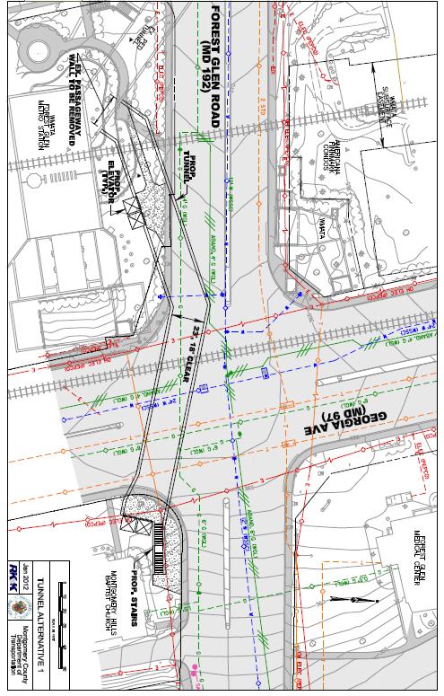
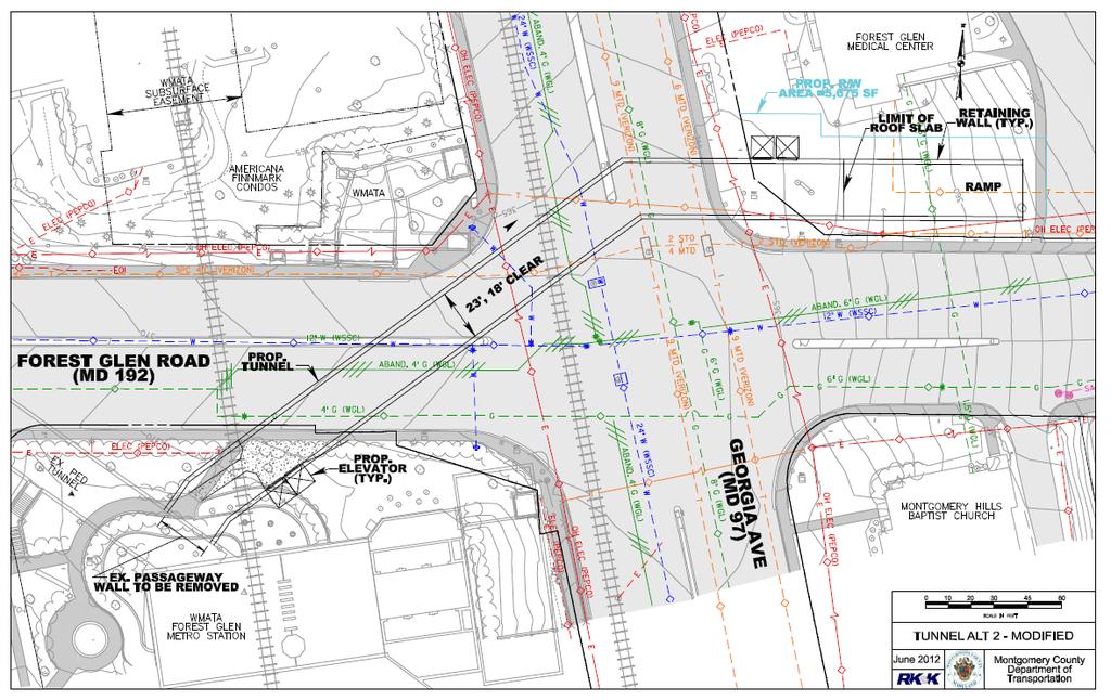
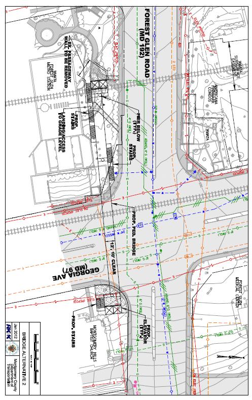
4 1) Tunnel Alternative 1, across the south leg of the intersection, which would connect the Metrorail Station on the southwest to the southeast corner of Georgia Avenue and Forest Glen Road (Attachment 1); 2) Tunnel Alternative 2, diagonally across the intersection, which would connect the Metrorail Station on the southwest to the northeast corner of Georgia Avenue and Forest Glen Road (Attachment 2); and 3) Bridge Alternative 2, across the south leg of the intersection, which would connect the Metrorail Station on the southwest to the southeast corner of Georgia Avenue and Forest Glen Road (Attachment 3). Detailed information about all three Alternatives, their costs, estimated construction times, potential users and impacts are listed in Table 1 below: 4
5 Table 1: Summary of the Three Alternatives Tunnel Alternative 1 (SE Quadrant to Metro) Tunnel Alternative 2 (NE Quadrant to Metro) Bridge Alternative 2 (SE Quadrant to Metro) Length (Ft.) Width (Ft.) 23 (18 Ft Clear) 23 (18 Ft Clear) 12 (10 Ft Clear) Estimated Pedestrian Usage (Crossing MD 97/Day)* Average Travel Time Savings (Sec/Pedestrian) Construction Duration 39 months 39 months 15 months Maintenance of Traffic Partial Night Time Work (18 months) Overnight Lane Closures to 2 3 Lanes on Georgia Ave and Forest Glen Rd Partial Night Time Work (18 months) Overnight Lane Closures to 2 3 Lanes on Georgia Ave and Forest Glen Rd Partial Night Time Work (3 months) Overnight Lane Closures to 2 3 Lanes on Georgia Ave. Single overnight complete closure of Georgia Ave Properties Impacted 1 Property, 2200 Square Feet 1 Property, 5700 Square Feet 1 Property, 1500 Square Feet Natural Resource Impacts Low Low Low Cultural Impacts Potential Impacts to Montgomery Hills Baptist Church None Potential Impacts to Montgomery Hills Baptist Church Utility Impacts High Underground, overhead and traffic signal High Underground, overhead and traffic signal Moderate Overhead and traffic signal Construction Cost $11.5 M $12.7 M $5.8 M Total Cost** $15.6 M $17.9 M $8.6 M * These numbers are revised, and different from the Feasibility Study Data ** Total Cost includes Planning, Engineering, Land Acquisition, Tunnel/Bridge, and Bike Share Stations Master Plan Consistency This intersection is subject to the 1996 Forest Glen Sector Plan and the 2000 North and West Silver Spring Master Plan. The 1996 Forest Glen Sector Plan considered a pedestrian bridge or tunnel crossing of Georgia Avenue at Forest Glen, but favored at-grade pedestrian crossing improvements for the following reasons (page 53): The cost of constructing a tunnel or bridge at this location would be prohibitively high, especially when compared to the potential usage. A potential conflict with Metrorail underground construction would exist. The ramps for a pedestrian bridge would adversely affect the properties on the corners of the intersection. Experience indicates that these structures are not used by all pedestrians and, therefore, the need would remain for a signalized at-grade crossing. The need for a bicycle crossing is not adequately met by building a tunnel or bridge. Perceived and real safety concerns with a tunnel require extensive lighting and other security measures. The recommendation to provide at-grade pedestrian and bicycle access across Georgia Avenue on the north side of the intersection, and the construction of wider medians, provide the best, most usable and lowest cost alternative. 5
6 However, the Sector Plan does state that the transportation system must provide for safe and efficient movements for all modes of travel, including bicyclists and pedestrians. The Sector Plan also recommends constructing a sidewalk on the north side of Forest Glen Road between Sligo Creek and Woodland Drive (page 51). Staff concurs with these recommendations and believes that the Sector Plan s guidance is still relevant and valid with respect to the construction of the Passageway. The 2000 North and West Silver Spring Master Plan states that MDSHA should study Georgia Avenue from 16 th Street to Dennis Avenue with the goal of making Montgomery Hills more pedestrian and vehicular friendly. (page 52) The Master Plan also states that the MDSHA study should include the Forest Glen Road intersection. As noted above, MDSHA has recently initiated this study, which should be completed before funding is committed for a grade-separated passageway. If the difficulties and complexity of creating a better, at-grade crossing of Georgia Avenue (lack of a median, ROW constraints, impacts on traffic) prove insurmountable, staff believes that providing a grade-separated passageway at this location would be consistent with the overall goals of the Sector Plan of providing safe and convenient circulation options for pedestrians, bicyclists and other non-motorized traffic in Forest Glen (page 31). SUMMARY OF THE STUDY The study analyzed accident data from and found that there were eighty-four (84) reported crashes at this intersection with no fatalities. Of the 84 crashes, eleven (11) were pedestrian involved, the highest number in one year was five (5) reported in The Study conducted four (4) separate sets of pedestrian counts and surveys. The first set looked at the total number of pedestrians crossing each of the four legs of the intersection during AM and PM peak hours (the top two diagrams in Figure 1 below), and over a 13-hour period (6:00 AM to 7:00 PM) (third diagram in Figure 1 below). These counts showed that the peak-hour (for pedestrians) was 7:00-8:00 AM and 5:45 PM to 6:45 PM, and that during the 13-hour period the highest counts occurred across the south leg of Georgia Avenue (237 eastbound and 230 westbound, Figure 1). The second set found that over a 13-hour period a total of 223 pedestrians ( ) crossed from northeast to the Metro Station on the southwest corner of the intersection (Figure 2). The third set was a survey of pedestrians walking along Forest Glen Road from the southwest corner to the Metrorail Station entrance to the west. This survey found that during the AM peak-hour, 97% of the pedestrians crossing Georgia Avenue were traveling to the Metrorail Station (the remaining 3% presumably continued west along Forest Glen Road). During the PM peak hour, 99% of pedestrians leaving the Metro Station crossed Georgia Avenue to the reach the southeast corner. The fourth set of counts was an origin-destination (O-D) survey, during peak periods, whose primary objective was to determine whether a Southeast-to-Southwest passageway alignment would serve significantly more pedestrians than a Northeast-to-Southwest alignment. The survey found that pedestrians who arrived at the southeast corner, and were travelling to the southwest corner, 11 out of 52 (21%) in the morning had already crossed Forest Glen Road from the north side to the south side, and 1 out of 13 (8%) in the afternoon were going to cross Forest Glen Road from the south side to the north further east of the intersection. The study found that a larger share of pedestrians originated from the northeast quadrant (52 out of 75). 6
7 Figure 1: AM and PM Peak Hour Pedestrian Crossing Volumes and total 13 hour Pedestrian Crossing Volumes Traffic Signal Operations The Study evaluated if at-grade pedestrian crossings, or pedestrian signal phases, could be eliminated, if the passageway were constructed. The study found that it was not possible to eliminate any at-grade crossings. Replacing only one of the crosswalks with a passageway would require the same pedestrian signal phasing as if the crosswalk was still there, because the remaining crosswalk would still require a pedestrian phase. The study also looked at: 1) Whether the signal timing could be optimized to increase the overall operations of the intersection; and; 2) What impact would increasing the pedestrian crossing time at Georgia Avenue and Forest Glen Road have on the intersection operation. 7
8 The Study found that the current signal is timed to provide better performance for Georgia Avenue traffic at the expense of increased delay on Forest Glen Road. It also concluded that the pedestrian signal does not provide adequate pedestrian crossing time (based on industry standards set by the Manual on Uniform Traffic Control Devices (MUTCD)). Providing adequate pedestrian crossing time would increase the delay per vehicle for the whole intersection from an average of 45.5 seconds per vehicle to 54.8 seconds per vehicle during the AM peak hour, and from 30.8 seconds per vehicle to 33.0 seconds per vehicle during the PM peak hour. Figure 2: Total 13-hour Pedestrian Volumes from the Special Southwest-Northeast Count ANALYSIS Although the Study took four different counts of pedestrians at this location, it still lacks a clear picture of pedestrians behavior and their origin-destination pattern. Although the Study recognizes that the highest number of pedestrians comes from the northeast quadrant, it projects a higher number for potential Metro users for the Tunnel Alternative 1 (SE-SW): approximately 834 users for Tunnel Alternative 1 (SE-SW), 799 for Tunnel Alternative 2 (NE-SW), and 683 for Bridge Alternative (Table 1 on page 4). Staff questions these projections because the existing counts show that more Metro users 8
 is much smaller than the northeast quadrant, and therefore generates far fewer Metro users than the")
9 originate in the Northeast Quadrant. And, the existing and future land use scenarios clearly show that there are far fewer houses in the SE quadrant than the northeast quadrant. The southeast quadrant bounded by the Beltway, the Holy Cross Hospital and the Forest Glen Road) is much smaller than the northeast quadrant, and therefore generates far fewer Metro users than the northeast quadrant (Map 2). Map 2: Half Mile Radius Around Metrorail Station The study s pedestrian counts and O-D surveys have demonstrated that some of the users arriving at the southeast corner actually were from the northeast quadrant, but crossed Forest Glen Road from the north side to the south side further east, which means that some of the users projected to be from the southeast quadrant actually live in the northeast quadrant, and therefore would prefer to stay on the north side of Forest Glen Road if the tunnel entrance was in the northeast corner. More specifically, the study found that 52 out of 75 pedestrians travelling from the Metro Station across Georgia Avenue to the east side were headed to the northeast quadrant while only 23 were from the southeast quadrant. Staff understands the study s assumption that more of the NE quadrant residents will be willing to cross Forest Glen Road to use the entrance of Tunnel Alternative 1 (SE-SW) than the number of southeast quadrant residents willing to cross Forest Glen Road to go north to access the tunnel entrance at the northeast corner for Tunnel Alternative 2 (NE-SW), since the northeast residents will have no option but to cross Forest Glen Road at-grade if the tunnel entrance was at the southeast corner. However, it is also 9
10 likely that some of the users would continue to cross Georgia Avenue instead of crossing Forest Glen Road at-grade, especially if they arrive at the northeast corner when the pedestrian signal is on to cross Georgia Avenue at-grade across the north leg of the intersection. Staff believes that Tunnel Alternative 1 (SE-SW) fails to meet the basic goal of the project to provide a grade-separated access to the Metro Station, requested mostly by the northeast quadrant residents by requiring the largest number of Metro users to continue to cross Forest Glen Road at-grade to access the tunnel at the southeast corner. Staff believes that the tunnel should be built for the convenience of the maximum users, i.e., those from the northeast quadrant, and not force them to cross Forest Glen Road to access the entrance at the southeast corner for the Tunnel Alternative 1 (SE-SW tunnel). Staff agrees with the MCDOT s conclusion that a bridge is not a viable alternative. Metro users are already below grade using the existing Metro tunnel, and they are more likely to continue travelling below grade to cross Georgia Avenue at that level. The bridge option would require a majority of pedestrians coming to the station from the northeast to cross Forest Glen Road at-grade, take an elevator or stairs to the bridge level to access the bridge, cross Georgia Avenue, and go down two levels to access the station. A bridge would also create more challenges of safety and visual impacts of such a large structure at this location. Given all these constraints, staff believes that the estimated number of bridge users projected in the study is too high. COMMUNITY OUTREACH On April 10, 2012, MCDOT held a public meeting to present the Alternatives for the Passageway at the Sligo Middle School. Approximately 70 citizens attended the meeting. There were several concerns expressed at the public meeting. First, citizens believed that the projected usage numbers for the three alternatives did not seem realistic (these number have since been revised by the MCDOT s consultant). Second, citizens stressed that traffic along Georgia Avenue was perceived as dangerous and made crossing Georgia Avenue to access the Metrorail Station seem dangerous. Third, the construction of a grade-separated passageway entrance on the east side of Georgia Avenue would cause additional traffic (and potentially traffic conflicts) along Forest Glen Road on the east side of Georgia Avenue as vehicles would stop to discharge and pick up Metrorail riders. MCDOT response was that they will monitor the traffic conditions once the passageway is constructed and take appropriate measures to address such concerns. TIGER GRANT APPLICATIONS While MCDOT has not chosen a Selected Alternative, MCDOT has submitted two applications to the USDOT with Tunnel Alternative 1 as their preferred alignment (SE-SW connection). On October 31, 2011, the Metropolitan Washington Council of Governments (MWCOG), on behalf of MCDOT, submitted an application for funding for the Tunnel Alternative 1 to the US Department of Transportation (USDOT) from the FY 2011 TIGER Grant 3. Grant winners were announced in December of 2011, and the Forest Glen Passageway was not selected. On March 16, 2012 MWCOG submitted another application for the Tunnel Alternative 1 for TIGER Grant 4. Grant winners were announced in June of this year, and the Forest Glen Passageway was not selected. Currently, there are no funding sources identified for the project. 10
11 CONCLUSION Based on information provided by the Applicant and the analysis contained in this report, Staff finds that the most desirable alternative is for MCDOT to improve at-grade crossing of Georgia Avenue. Staff believes that although allowing adequate time for pedestrian crossing of Georgia Avenue will create significant delays on Georgia Avenue (southbound AM), MCDOT should explore increasing the pedestrian crossing time to at least meet the industry standards (MUTCD suggested standard). In addition, MCDOT should provide a sidewalk along the north side of Forest Glen Road between Georgia Avenue and the Holy Cross Hospital. This sidewalk was suggested in the 1996 Forest Glen Sector Plan and would improve pedestrian safety in this area. If a grade-separated crossing is to be constructed, Staff believes that Tunnel Alternative 2 (NE-SW) is the best alternative for the following reasons: 1. It would provide the most direct, grade-separated passage for the highest number of Metro users, mainly those from the northeast quadrant. 2. Due to a significant drop in topography at the northeast corner, it would eliminate the need for stairs at the eastern terminus of the tunnel. 3. Unlike the Tunnel Alternative 1 (SE-SW), It would not require a majority of the potential users to continue to cross Forest Glen Road at Georgia Avenue to access the tunnel entrance. Staff recommends selecting Tunnel Alternative 2 as the preferred alternative with comments listed at the front of this report. MLDG:ha: n:\area 2 division\lewis-degrace\forest glen\forest glen passageway mr final Attachments: 1. Tunnel Alternative 1 2. Tunnel Alternative 2 Modified 3. Bridge Alternative 2 11
12 Attachment 1 12
13 Attachment 2 13
14 Attachment 3 14
Blair/Williamson Intersection Expressed Needs
 Blair/Williamson Intersection Expressed Needs NORTH Blair Street is a barrier for pedestrians and bicycles Relocate Capitol City Trail crossing from Blair Street and John Nolen Drive intersection to Williamson
Preliminary Transportation Analysis
 Preliminary Transportation Analysis Goals of a Robust, Multimodal Transportation Network Safe Accessible/Connected Efficient Comfortable Context-Sensitive Motor Vehicle: Continue to analyze the data to
Improving Cyclist Safety at the Dundas Street West and Sterling Road Intersection
 STAFF REPORT ACTION REQUIRED Improving Cyclist Safety at the Dundas Street West and Sterling Road Intersection Date: August 17, 2012 To: From: Wards: Reference Number: Public Works and Infrastructure Committee
Project Description Form 8EE
 Project Description Form 8EE Basic Project Information Submitting Jurisdiction/Agency: Town of Dumfries Project Title: Route 1 (Fraley Blvd) Widening: Brady's Hill Road to Dumfries Road Project Location:
ALLEY 24 TRAFFIC STUDY
 ALLEY 24 TRAFFIC STUDY in City of Frostburg, Maryland January 2013 3566 Teays Valley Road Hurricane, WV Office: (304) 397-5508 www.denniscorporation.com Alley 24 Traffic Study January 2013 Frostburg, Maryland
Approximately 360 trail users cross during a typical summer weekday and 420 cross during a typical summer
 5. PARKR ROAD AT MISSISSIPPI AVN CROSSIN xisting Conditions The High ine Canal trail crosses Parker Road near the Mississippi Avenue intersection (crossing location #3 on Figure 1). South of Parker, the
City of Sammamish. Welcome. Issaquah-Fall City Road Improvements Project Phase I Design: 242nd Avenue SE to Klahanie Drive SE
 Welcome Welcome to the third community meeting for the Issaquah-Fall City Road Improvements Project. AGENDA 6:00 p.m. Welcome and sign-in 6:10 p.m. Presentation 6:50 p.m. Open house Learn about the roadway
APPENDIX 2 LAKESHORE ROAD TRANSPORTATION REVIEW STUDY EXECUTIVE SUMMARY
 APPENDIX 2 LAKESHORE ROAD TRANSPORTATION REVIEW STUDY EXECUTIVE SUMMARY Appendix 2 City of Mississauga Lakeshore Road FINAL REPORT Transportation Review Study December 2010 EXECUTIVE SUMMARY Study Purpose
Bikeway action plan. Bicycle Friendly Community Workshop March 5, 2007 Rochester, MN
 Bikeway action plan Summary The was held on March 5, 2007 at the Rochester Mayo Civic Center. The workshop was hosted by Rochester-Olmsted County Planning Department in collaboration with the League of
APPENDIX G: INTERSECTION NEEDS AT OKEECHOBEE BOULEVARD
 APPENDIX G: INTERSECTION NEEDS AT OKEECHOBEE BOULEVARD INTERSECTION NEEDS AT SR 7 and OKEECHOBEE BOULEVARD SR 7 Extension Project Development and Environment (PD&E) Study From Okeechobee Boulevard (SR
Access Management Regulations and Standards
 Access Management Regulations and Standards January 2014 Efficient highway operation Reasonable property access Concept of Access Management The way to manage access to land development while preserving
MONTGOMERY COUNTY PLANNING DEPARTMENT THE MARYLAND-NATIONAL CAPITAL PARK AND PLANNING COMMISSION
 MONTGOMERY COUNTY PLANNING DEPARTMENT THE MARYLAND-NATIONAL CAPITAL PARK AND PLANNING COMMISSION SHA CTP Project No. MO891A21, US 29, Fairland Road to Musgrove Road Interchange Improvement, Design Review
INNOVATIVE INTERSECTION DESIGN
 INNOVATIVE INTERSECTION DESIGN J. Eddie Valtier, P.E. ELP TP&D Director Introduction Why Do We Need To Start Looking For Innovative Intersection Designs? Congestion is worsening and traffic volumes and
Route 29 Solutions Projects
 Route 29 Solutions Route 29 Solutions Projects www.route29solutions.org October 10, 2014 Route 29 Widening to Six Lanes Albemarle County This project will widen a 1.8-mile segment of Route 29 from four
DISTRIBUTION: Electronic Recipients List TRANSMITTAL LETTER NO. (17-01) MINNESOTA DEPARTMENT OF TRANSPORTATION. MANUAL: Road Design English Manual
 MINNESOTA DEPARTMENT OF TRANSPORTATION. MANUAL: Road Design English Manual") DISTRIBUTION: Electronic Recipients List MINNESOTA DEPARTMENT OF TRANSPORTATION DEVELOPED BY: Design Standards Unit ISSUED BY: Office of Project Management and Technical Support TRANSMITTAL LETTER NO.
DISTRIBUTION: Electronic Recipients List MINNESOTA DEPARTMENT OF TRANSPORTATION DEVELOPED BY: Design Standards Unit ISSUED BY: Office of Project Management and Technical Support TRANSMITTAL LETTER NO.
CITY OF LOS ANGELES INTER-DEPARTMENTAL MEMORANDUM
 CITY OF LOS ANGELES INTER-DEPARTMENTAL MEMORANDUM Date: April 1, 219 To: Honorable City Council c/o City Clerk, Room 395, City Hall Attention: Honorable Mike Bonin, Chair, Transportation Committee From:
Feasibility Study of Pedestrian Crossings Along Route 7, East of Cascades Parkway and West of Dranesville Road. October 3, 2017
 Feasibility Study of Pedestrian Crossings Along Route 7, East of Cascades Parkway and West of Dranesville Road October 3, 2017 Study Area (area within a ¼-mile radius of the study intersections) Route
Orange Center Elementary School
 Drag and drop pic and stretch/crop to the limits of the blue rectangle (delete this text box) Orange Center Elementary School Drag and drop pic and stretch/crop to the limits of the blue rectangle (delete
Supervisor Cook Announces Final Plans for Braddock Road Improvement Project
 Supervisor Cook Announces Final Plans for Braddock Road Improvement Project After more than two years of study and significant community input, I am pleased to announce the final plans for the Braddock
Complete Street Analysis of a Road Diet: Orange Grove Boulevard, Pasadena, CA
 Complete Street Analysis of a Road Diet: Orange Grove Boulevard, Pasadena, CA Aaron Elias, Bill Cisco Abstract As part of evaluating the feasibility of a road diet on Orange Grove Boulevard in Pasadena,
Bellevue Downtown Association Downtown Bike Series
 Bellevue Downtown Association Downtown Bike Series Meeting 2 Franz Loewenherz Andreas Piller Kyle Potuzak Chris Long October 26, 2017 Today s Agenda: 1) Meeting Purpose 2) 9/28 Meeting Recap 3) Candidate
Highway 49, Highway 351 and Highway 91 Improvements Feasibility Study Craighead County
 Highway 49, Highway 351 and Highway 91 Improvements Feasibility Study Craighead County Executive Summary March 2015 Highway 49, Highway 351 and Highway 91 Improvements Feasibility Study Craighead County
Summary: Mercer County Princeton Avenue & Spruce Street Study January 2009
 Summary: Several recent studies have assessed potential development and redevelopment opportunities in the Mercer Crossing area of Trenton, Ewing, and Lawrence. This Princeton Avenue and Spruce Street
Hidden Oaks Elementary School
 Hidden Oaks Elementary School SCHOOL ROUTE PLAN For HIDDEN OAKS ELEMENTARY SCHOOL LOCATION 13 ORANGE COUNTY Prepared for: ORANGE COUNTY SCHOOL ASSESSMENT PROGRAM ORANGE COUNTY PUBLIC WORKS Traffic Engineering
Access Management Regulations and Standards
 Access Management Regulations and Standards Efficient highway operation Reasonable property access Concept of Access Management The way to manage access to land development while simultaneously preserving
VDOT I-66 Inside the Beltway Eastbound Widening Environmental Assessment. Staff Recommendations
 VDOT I-66 Inside the Beltway Eastbound Widening Environmental Assessment Staff Recommendations Department of Environmental Services Transportation January 28, 2017 Timeline of Transform66 June 2012: I-66
Southwest Bus Rapid Transit (SW BRT) Functional Planning Study - Executive Summary January 19 LPT ATTACHMENT 2.
 Functional Planning Study - Executive Summary January 19 LPT ATTACHMENT 2.") Southwest Bus Rapid Transit (SW BRT) Functional Planning Study - Executive Summary 2011 January 19 1 of 19 Introduction This executive summary presents the results of the Southwest Bus Rapid Transit (SW
Southwest Bus Rapid Transit (SW BRT) Functional Planning Study - Executive Summary 2011 January 19 1 of 19 Introduction This executive summary presents the results of the Southwest Bus Rapid Transit (SW
4. ENVIRONMENTAL IMPACT ANALYSIS 9. TRANSPORTATION AND TRAFFIC
 4. ENVIRONMENTAL IMPACT ANALYSIS 9. TRANSPORTATION AND TRAFFIC 4.9.1 INTRODUCTION The following section addresses the Proposed Project s impact on transportation and traffic based on the Traffic Study
DEPARTMENT OF ENVIRONMENTAL SERVICES. North Harrison Street (Lee Highway to Little Falls Road) Comparative Analysis. Prepared for:
 Comparative Analysis. Prepared for:") DEPARTMENT OF ENVIRONMENTAL SERVICES North Harrison Street (Lee Highway to Little Falls Road) Comparative Analysis Prepared for: Arlington County Department of Environmental Services 2100 Clarendon Boulevard,
DEPARTMENT OF ENVIRONMENTAL SERVICES North Harrison Street (Lee Highway to Little Falls Road) Comparative Analysis Prepared for: Arlington County Department of Environmental Services 2100 Clarendon Boulevard,
Chapter 4 Traffic Analysis
 Chapter 4 Traffic Analysis PURPOSE The traffic analysis component of the K-68 Corridor Management Plan incorporates information on the existing transportation network, such as traffic volumes and intersection
See Figure 38, Existing Nonmotorized Connections.
 Nonmotorized Connections Existing Nonmotorized Connections Pedestrian, vehicle and bike traffic access and movements are confined primarily to Penny Drive on campus. Due to the steep slope along the length
Windy Ridge Elementary School
 Windy Ridge Elementary School SCHOOL ROUTE PLAN For WINDY RIDGE ELEMENTARY SCHOOL LOCATION 54 ORANGE COUNTY Prepared for: ORANGE COUNTY SCHOOL ASSESSMENT PROGRAM ORANGE COUNTY PUBLIC WORKS Traffic Engineering
Fitting Light Rail through Well-established Communities
 Fitting Light Rail through Well-established Communities San Francisco 2008 Michael D. Madden Chief, Project Development, Maryland Transit Administration Project Setting Located inside the Capital Beltway
TAKOMA METRO STATION
 TKOM METRO STTION Traffic nalysis Technical Memorandum Station Planning in Support of Joint evelopment Job No. 13-FQ165-LN-2 November 213 WSHINGTON METROPOLITN RE TRNSIT UTHORITY (WMT) Takoma Metro Station
Traffic Impact Memorandum. May 22, 2018
 BISHOP PROFESSIONAL DEVELOPMENT BUILDING Proposed Land-use Change & Parking Modification 3601 SW 31st Street Topeka, Kansas 66614 CFS Project No. 185077 Traffic Impact Memorandum May 22, 2018 Prepared
Scarlett Road Bridge & Road Improvements Lambton Park Community School - Gymnasium Tuesday November 28 th, 2017
 Scarlett Road Bridge & Road Improvements Lambton Park Community School - Gymnasium Tuesday November 28 th, 2017 PROJECT LOCATION 2 SCARLETT ROAD BRIDGE Constructed in 1912, the bridge carries 4 active
Ownership Lots 17 & 18 (Part of Lot 14), Montgomery Auto Sales Park
, Montgomery Auto Sales Park") Traffic Impact Analysis Ownership Lots 17 & 18 (Part of Lot 14), Montgomery Auto Sales Park Silver Spring, MD Lot 17: Site Plan No. 821413 Lot 18: Site Plan No. 821414 Filing Number: 13-TS-1198527A Prepared
Traffic Impact Analysis Ownership Lots 17 & 18 (Part of Lot 14), Montgomery Auto Sales Park Silver Spring, MD Lot 17: Site Plan No. 821413 Lot 18: Site Plan No. 821414 Filing Number: 13-TS-1198527A Prepared
CTDOT Pedestrian and Bicycle Safety Initiatives
 CTDOT Pedestrian and Bicycle Safety Initiatives 2017 Northeast Transportation Safety Conference Mark F. Carlino, P.E. Traffic Engineering Division Chief Bureau of Engineering and Construction Connecticut
Figure 1: East West Connector Alignment Alternatives Concept Drawing
 Page 2 of 9 Figure 1: East West Connector Alignment Alternatives Concept Drawing The Montebello Drive extension will run north south and connect Wilsonville Road to the Boones Ferry Road to Brown Road
A plan for improved motor vehicle access on Railroad Avenue in Provincetown
 A plan for improved motor vehicle access on Railroad Avenue in Provincetown February 2011 A plan for improved motor vehicle access on Railroad Avenue in Provincetown INTRODUCTION AND PROBLEM IDENTIFICATION
Proposed. City of Grand Junction Complete Streets Policy. Exhibit 10
 Proposed City of Grand Junction Complete Streets Policy Exhibit 10 1 City of Grand Junction Complete Streets Policy Vision: The Complete Streets Vision is to develop a safe, efficient, and reliable travel
INNOVATIVE INTERSECTION SOLUTIONS. Jay Bockisch, PE, PTOE Senior Associate
 INNOVATIVE INTERSECTION SOLUTIONS Jay Bockisch, PE, PTOE Senior Associate INNOVATIVE INTERSECTION SOLUTIONS Innovative intersection overview Case studies Continuous flow intersection Modern roundabouts
6.0 PEDESTRIAN AND BICYCLE FACILITIES 6.1 INTRODUCTION 6.2 BICYCLE DEMAND AND SUITABILITY Bicycle Demand
 6.0 PEDESTRIAN AND BICYCLE FACILITIES 6.1 INTRODUCTION Bicycle and pedestrian travel along and in the vicinity of the corridor is part of the vision of Somerset and Hunterdon counties and the integrated
Pine Hills Road Pedestrian/Bicycle Safety Study Board of County Commissioners Work Session
 Pine Hills Road Pedestrian/Bicycle Safety Study Board of County Commissioners Work Session February 20, 2018 Meeting Agenda Study Overview Existing Conditions Access Management Potential Gateway Features
J Street and Folsom Boulevard Lane Conversion Project (T ) Before and After Traffic Evaluation
 Before and After Traffic Evaluation") J Street and Folsom Boulevard Lane Conversion Project (T15125400) Before and After Traffic Evaluation Prepared by Transportation Division June 2014 Executive Summary On February 12, 2013, the City of Sacramento
J Street and Folsom Boulevard Lane Conversion Project (T15125400) Before and After Traffic Evaluation Prepared by Transportation Division June 2014 Executive Summary On February 12, 2013, the City of Sacramento
JONESBORO HIGHWAY 63 HIGHWAY 18 CONNECTOR STUDY
 JONESBORO HIGHWAY 63 HIGHWAY 18 CONNECTOR STUDY Craighead County May 2007 JONESBORO HIGHWAY 63 HIGHWAY 18 CONNECTOR STUDY Craighead County May 2007 Prepared by Planning and Research Division Arkansas State
6.4 RECOMMENDED IMPROVEMENTS
 6.4 RECOMMENDED IMPROVEMENTS 6.4.1 Williston Road Recommendations While all alternatives would be an improvement over existing conditions, Alternative 3B is recommended over the others because it provides
City of Gainesville Transportation/Roadway Needs PROJECT SUMMARY
 A1 Roadway Resurfacing $23,846,000 TYPE: Preservation of existing system Roadway resurfacing A2 Signal Replacement $6,000,000 TYPE: Preservation of existing system Replace traffic signals. B1 W 6th St
HENDERSON DEVELOPMENT 213, 217, 221, 221 ½, 223 HENDERSON AVENUE and 65 TEMPLETON STREET OTTAWA, ONTARIO TRANSPORTATION OVERVIEW.
 HENDERSON DEVELOPMENT 213, 217, 221, 221 ½, 223 HENDERSON AVENUE and 65 TEMPLETON STREET OTTAWA, ONTARIO TRANSPORTATION OVERVIEW Prepared for: 2294170 Ontario Inc. February 2, 2017 117-652 Report_1.doc
Offset Single Point Interchange I-25 at Rio Bravo Boulevard Albuquerque, New Mexico
 Offset Single Point Interchange I-25 at Rio Bravo Boulevard Albuquerque, New Mexico INSTITUTE OF TRANSPORTATION ENGINEERS 2016 WESTERN DISTRICT MEETING JULY 11, 2016 7/11/2016 1 Project Vicinity Map 7/11/2016
133 rd Street and 132 nd /Hemlock Street 132 nd Street and Foster Street MINI ROUNDABOUTS. Overland Park, Kansas
 133 rd Street and 132 nd /Hemlock Street 132 nd Street and Foster Street MINI ROUNDABOUTS Overland Park, Kansas September 1, 2017 TABLE OF CONTENTS 1. INTRODUCTION... 1 2. LITERATURE REVIEW... 1 3. CONCEPT
STREET AND HIGHWAY PLAN
 STREET AND HIGHWAY PLAN Introduction The street and highway system in the Winston-Salem Urban Area consists of thousands of miles of traffic carrying facilities, ranging from short local residential streets
TRANSPORTATION & MOBILITY
 TRANSPORTATION & MOBILITY ROADWAY SYSTEM There are approximately 40 miles of roadways in Manitou Springs. For planning purposes, roadways are typically assigned a functional classification which defines
Lee s Summit Road Improvement Study Public Open House June 7, 2007 Summary of Comment Card Responses
 Lee s Summit Road Improvement Study Public Open House June 7, 2007 Summary of Comment Card Responses Introduction At the Lee s Summit Road Improvement Study Public Open House held Thursday, June 7, 2007
Governance and Priorities Committee Report For the July 2, 2015 Meeting
 CITY OF VICTORIA For the July 2, 2015 Meeting To: Governance and Priorities Committee Date: From: Subject: Brad Dellebuur, A/Assistant Director, Transportation and Parking Services Executive Summary The
TRAFFIC IMPACT ANALYSIS
 TRAFFIC IMPACT ANALYSIS FOR THE CHAMPAIGN UNIT#4 SCHOOL DISTRICT PROPOSED HIGH SCHOOL (SPALDING PARK SITE) IN THE CITY OF CHAMPAIGN Final Report Champaign Urbana Urbanized Area Transportation Study 6/24/2014
Reference number /VP. Lafayette Downtown Congestion Study - Additional Traffic Analysis
 To James Hinkamp and Tony Coe, City of Lafayette Date January 19, 2017 Copies Reference number 243381/VP From Michael Iswalt and Vanessa Peers File reference 4-05 Subject Lafayette Downtown Congestion
APPENDIX E Evaluation of Improvement Alternatives
 APPENDIX E Evaluation of Improvement Alternatives Table E-1 Preliminary Comparison of Design Alternatives, Concord Table E-2 Preliminary Comparison of Route 2 Improvement Packages, Acton and Concord TABLE
Los Altos Hills Town Council - June 18, 2015 Palo Alto City Council June 22, AGENDA ITEM #2.B Presentation
 Los Altos Hills Town Council - June 18, 2015 Palo Alto City Council June 22, 2015 AGENDA ITEM #2.B Presentation Previous Presentations Los Altos Hills Town Council in May 2014 and February 2015 Palo Alto
Dr. M.L. King, Jr. Street North Complete Streets Resurfacing Opportunities HOUSING, LAND USE, AND TRANSPORTATION COMMITTEE MARCH 22, 2018
 Dr. M.L. King, Jr. Street North Complete Streets Resurfacing Opportunities HOUSING, LAND USE, AND TRANSPORTATION COMMITTEE MARCH 22, 2018 What s Happening The City plans to mill and resurface Dr. M.L.
INTRODUCTION THOROUGHFARE SYSTEM CLASSIFICATIONS
 INTRODUCTION The thoroughfare plan will assist public officials in the development of a specialized system for efficient and safe movement of vehicular traffic while minimizing potential conflicts with
DOWNTOWN MIAMI PEDESTRIAN PRIORITY ZONE
 DOWNTOWN MIAMI PEDESTRIAN PRIORITY ZONE AUGUST 6, 2013 DOWNTOWN MIAMI BY THE NUMBERS more than 200,000 people live, work, and play here every day is home to more than 1,000 events each year hosts more
Lake Whitney Elementary School
 Lake Whitney Elementary School SCHOOL ROUTE PLAN For LAKE WHITNEY ELEMENTARY SCHOOL LOCATION 18 ORANGE COUNTY Prepared for: ORANGE COUNTY SCHOOL ASSESSMENT PROGRAM ORANGE COUNTY PUBLIC WORKS Traffic Engineering
RM 620 FEASIBILITY STUDY
 RM 620 FEASIBILITY STUDY Sections 5 & 6 December 7, 2015 STUDY PROCESS Study Purpose and Goals The RM 620 Feasibility Study was launched by the Texas Department of Transportation (TxDOT) to analyze transportation
Project Report. South Kirkwood Road Traffic Study. Meadows Place, TX October 9, 2015
 Meadows Place, TX October 9, 2015 Contents 1 Introduction... 1 2 Data Collection... 1 3 Existing Roadway Network... 2 4 Traffic Volume Development... 2 5 Warrant Analysis... 3 6 Traffic Control Alternative
Clybourn Ave. Protected Bike Lane Study Halsted St. to Division St.
 Clybourn Ave. Protected Bike Lane Study Halsted St. to Division St. Nathan Roseberry, Senior Engineer Pam Broviak, Project Manager July 24, 2014 Agenda Project Goals Existing Roadway Conditions Traffic
2014/2015 BIKE ROUTE PLAN 83 AVENUE PROTECTED BIKE LANE
 About the Project 2014/2015 BIKE ROUTE PLAN The City of Edmonton is planning a major bike route on the south side of Edmonton. This bike route is one part of a plan to provide citizens with transportation
Donahue Drive Corridor Traffic Operational Evaluation
 Donahue Drive Corridor Traffic Operational Evaluation PREPARED FOR: THE CITY OF AUBURN PREPARED BY: JANUARY 2007 Donahue Drive Corridor Study--Auburn, Alabama TABLE OF CONTENTS Introduction... 1 Background
Non-Motorized Overpass at SR 5/US1
 Non-Motorized Overpass at SR 5/US1 And SR 97/SW th Street (Bird Road) Executive Summary March 9, 17 Prepared By: MARLIN Engineering Inc 17 NW th Avenue, Ste. 1 Plantation, FL 33313 P: 35.77.7575 www.marlinengineering.com
Proposed White Flint Separated Bike Lane Network September 2015
 Proposed White Flint Separated Bike Lane Network September 2015 Abstract This report includes a proposed separated bike lane network for the White Flint Sector Plan area. Separated bike lanes create a
STH 57 & STH 100 Intersection Village of Brown Deer Milwaukee County November 2015
 STH 57 & STH 100 Intersection Village of Brown Deer Milwaukee County November 2015 Introduction How we got to here WIS 57 Bridge over WIS 100 in need of replacement Local support favors At-Grade Intersection
Princeton Avenue and Spruce Street Transportation and Site Access Enhancements Project
 Princeton Avenue and Spruce Street Transportation and Site Access Enhancements Project Mercer County Planning Division AECOM Transportation (formerly DMJM Harris) January 29, 2009 Agenda Project Status
Frequently Asked Questions
 Frequently Asked Questions Business US 190 in Copperas Cove From Avenue D to Constitution Drive What is access management? A. Access Management is a growing effort by government agencies to improve how
Citywide Sidewalk and Crosswalk Programs
 Citywide Sidewalk and Crosswalk Programs Council Meeting October 20, 2015 Presented by Rita Hu and Jamal Mahmoud Program Goals Implement the City s comprehensive plan. Provide pedestrian with safe walking
Residential Traffic Calming Program Guide. Town of Ashland, Virginia
 Residential Traffic Calming Program Guide Town of Ashland, Virginia August 1, 2006 TABLE OF CONTENTS A. INTRODUCTION... 1 B. GOALS... 1 C. CRITERIA... 1 D. IDENTIFYING NEIGHBORHOOD TRAFFIC CONCERNS...
Welcome! San Jose Avenue Open House August 25, 2015
 Welcome! San Jose Avenue Open House August 25, 2015 Vision Zero The City and County of San Francisco adopted Vision Zero San Francisco Vision Zero High Injury Network as a policy in 2014, committing an
Goodlettsville Bicycle and Pedestrian Plan Executive Summary
 Goodlettsville Bicycle and Pedestrian Plan July 2010 In Cooperation with the Nashville Area Metropolitan Planning Executive Organization Summary Introduction Progressive and forward thinking communities
RCCG Jesus House. Preliminary Plan # TRAFFIC STUDY. Prepared for: RCCG Jesus House Montgomery County, Maryland
 TRAFFIC STUDY Prepared for: Montgomery County, Maryland Prepared by: SSSTS Consulting (410) 718-8660(410) 718-8660 Table of Contents SECTION 1 - INTRODUCTION... 1 SECTION 2 - EXISTING CONDITIONS... 4 Public
5 Transit & Traffic. Overview
 5 Transit & Traffic Overview Montgomery Place s roadways and overall traffic circulation are unique in the city due to the narrow streets and avenues with boulevards; however, no sidewalks or curbs in
Bicycle Facilities Planning
 Bicycle Facilities Planning Overview Types of Cyclists Purpose for Riding Types of Facilities Bike Lanes Bicycle Boulevards Cycle Tracks Intersections Signals Signing and Marking Discussion Types of Bicyclists
Town of Mooresville, North Carolina Neighborhood Traffic Calming and Control Device Policy
 Town of Mooresville, North Carolina Neighborhood Traffic Calming and Control Device Policy Adopted January 6, 2014 Town of Mooresville Development Services Department TOWN OF MOORESVILLE NEIGHBORHOOD TRAFFIC
TRANSPORTATION ANALYSIS REPORT US Route 6 Huron, Erie County, Ohio
 TRANSPORTATION ANALYSIS REPORT US Route 6 Huron, Erie County, Ohio December 12, 2012 Prepared for: The City of Huron 417 Main Huron, OH 44839 Providing Practical Experience Technical Excellence and Client
Bay to Bay Boulevard Complete Streets Project
 Bay to Bay Boulevard Complete Streets Project Dale Mabry Highway to Bayshore Boulevard February 08, 2018 Photo Source: Tampa Bay Times Alessandra Da Pra Meeting Format Introduction Resurfacing Information
Caltrans Sloat Boulevard Pedestrian Safety Project Response to Community Questions, Comments & Concerns
 Caltrans Sloat Boulevard Pedestrian Safety Project Response to Community Questions, Comments & Concerns Revised: May 10, 2016 The California Department of Transportation (Caltrans) is planning various
AGENDA REPORT. Issue: Discussion of potential improvements on Barnwell Road at Niblick Drive
 AGENDA REPORT To: From: By: Honorable Mayor and City Council Members Warren Hutmacher, City Manager Tom Black, Public Works Director Date: March 23, 2016 Agenda: March 28, 2016 WORK SESSION AGENDA: Barnwell
C C C
 C-012-001 Thank you for your support for the creation of new public space and nonmotorized access between downtown and the waterfront through the Overlook Walk, the East-West Connections, and the Promenade.
1 st and 2 nd Street Couplet FAQ s
 1 st and 2 nd Street Couplet FAQ s Q. Will the proposed roundabout at Flume/2nd/1 st Streets affect access to businesses nearby?... 2 Q. What if the project isn t received well by the community after construction?...
ENHANCED PARKWAY STUDY: PHASE 2 CONTINUOUS FLOW INTERSECTIONS. Final Report
 Preparedby: ENHANCED PARKWAY STUDY: PHASE 2 CONTINUOUS FLOW INTERSECTIONS Final Report Prepared for Maricopa County Department of Transportation Prepared by TABLE OF CONTENTS Page EXECUTIVE SUMMARY ES-1
1609 E. FRANKLIN STREET HOTEL TRAFFIC IMPACT STUDY EXECUTIVE SUMMARY
 1609 E. FRANKLIN STREET HOTEL TRAFFIC IMPACT STUDY EXECUTIVE SUMMARY Prepared for: The Town of Chapel Hill Public Works Department Traffic Engineering Division Prepared by: HNTB North Carolina, PC 343
SCHOOL ROUTE PLAN. For HUNTER S CREEK ELEMENTARY SCHOOL LOCATION 14 ORANGE COUNTY. Prepared for:
 SCHOOL ROUTE PLAN For HUNTER S CREEK ELEMENTARY SCHOOL LOCATION 14 ORANGE COUNTY Prepared for: ORANGE COUNTY SCHOOL ASSESSMENT PROGRAM ORANGE COUNTY PUBLIC WORKS Traffic Engineering Division 42 South John
City of Seattle Edward B. Murray, Mayor
 City of Seattle Edward B. Murray, Mayor Department of Transportation Scott Kubly, Director Eastlake Community Council 117 E Louisa St. #1 Seattle, WA 98102-3278 January 28, 2016 RE: Roosevelt to Downtown
Existing Transportation System
 < Open for Additional Text Transportation System Existing Transportation System This section describes vehicular transportation associated with Children s. transportation are described in a separate section
Meadow Woods Elementary School
 Drag and drop pic and stretch/crop to the limits of the blue rectangle (delete this text box) Meadow Woods Elementary School Drag and drop pic and stretch/crop to the limits of the blue rectangle (delete
Public Information Centre
 WELCOME Public Information Centre Father Tobin Road Lougheed Middle School - Library Wednesday November 7, 2012 7:00 p.m.to 9:00 p.m. Please sign in Neighbourhood Traffic Calming Guide Background The City
TRAFFIC IMPACT STUDY And A TRAFFIC SIGNAL WARRANT ANALYSIS FOR A SENIOR LIVING AND APARTMENT DEVELOPMENT
 TRAFFIC IMPACT STUDY And A TRAFFIC SIGNAL WARRANT ANALYSIS FOR A SENIOR LIVING AND APARTMENT DEVELOPMENT DEERFIELD TOWNSHIP, WARREN COUNTY, OHIO Nantucket Circle and Montgomery Road () Prepared for: ODLE
Chapter 5 Future Transportation
 Chapter 5 Future Transportation The Future Land Use Plan identifies the desired land use designations. The land uses desired for Crozet depend, in large part, on the success of the transportation system,
June 29, Dear Mr. Walter:
 From: CountyBoard@arlingtonva.us To: chickandsandy@msn.com Subject: County Board Response Regarding the Arlington Ridge Road Improvement Project (Intranet Quorum IMA00252707) Date: Wed, 29 Jun 2011 08:09:53-0400
ORANGE COUNTY PUBLIC WORKS TRAFFIC INVESTIGATIONS
 ORANGE COUNTY PUBLIC WORKS TRAFFIC INVESTIGATIONS STAFF REPORT OF: January 6, 2019 SUPERVISORIAL DISTRICT: 5 SUBJECT: LOCATION: INVESTIGATOR: O Neill Drive at Roanoke Drive; Ladera Ranch; TB 922-E6 Clever
Pattullo Bridge Replacement Project Community Connections Phase 2 Consultation. Appendix 3: Open House Display Boards
 Replacement Project Community Connections Phase 2 Consultation Appendix 3: Open House Display Boards November 2016 Welcome! Welcome to the Replacement Project Public Open House We Want to Hear from You
PRELIMINARY DRAFT WADDLE ROAD / I-99 INTERCHANGE PROJECT ALTERNATIVE ANALYSIS FINAL TRAFFIC SUMMARY REPORT
 PRELIMINARY DRAFT WADDLE ROAD / I-99 INTERCHANGE PROJECT ALTERNATIVE ANALYSIS FINAL TRAFFIC SUMMARY REPORT Prepared by: In Association with: November 2013 EXECUTIVE SUMMARY Patton Township, in partnership