Option W: N. Washington Street Project
|
|
|
- Aubrey Randall
- 6 years ago
- Views:
Transcription
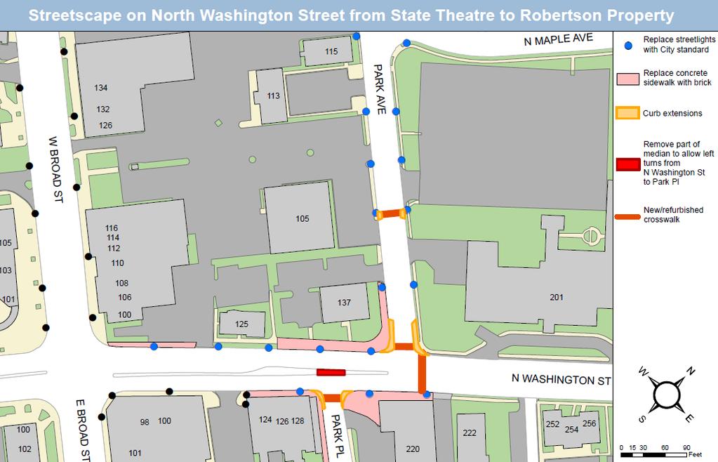
1 Option W: N. Washington Street Project Location: one block of North Washington Street, between West Broad Street and Park Avenue Description: upgrades to existing lighting new brick sidewalk to replace existing concrete new accessible curb ramps, curb extensions and a marked crossing at Park Place additional marked crossing at Park Avenue Cost: $160,000
2
3 Option B: W. Broad Street Project Location: two blocks of West Broad Street, between North Washington Street and Little Falls Street Description: upgrade to existing lighting (convert to LED and refurbish poles) new sidewalk brick pavers, as needed replant tree pits refresh crosswalks (thermoplastic markings) new conduit for electric and/or fiber optic in the utility strip sidewalk weed removal and pressure washing
4 three of the signal mast arms at Washington/Broad will be replaced o one existing NE mast arm has been damaged by a vehicle and will be replaced o two existing mast arms on the south side of the intersection are not the City standard decorative mast arms and would be replaced Cost: $506,000
5 Option S: LED Street Light Conversion Location: West Broad Street from Little Falls to Haycock Description: streetlight refurbishment (painting/part replacements) conversion to LED of the approximately 80 existing City streetlights depending upon contractor availability (i.e., number of crews available), may add 4 months to the work schedule Cost: $150,000
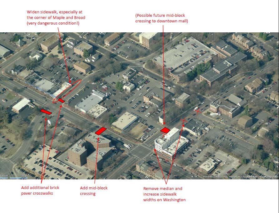
6 DOWNTOWN REINVESTMENT OPTIONS Notes from Meeting with Downtown Businesses January 9, 2015 Option W Comments: Can the median on N. Washington St. be removed or narrowed to create space to widen the sidewalk on the east side of the street? Staff s answered that the median could be removed, and along with a few other adjustments, could gain perhaps 2-4 feet of sidewalk. There was no consensus that a tradeoff of median for sidewalk space is preferable. Option B Comments: Do not replace the City trees any time soon. The trees are now reaching a size where business signage is less obscured. The VPIS investment of $10,000 several years ago for flowers and shrubs in sidewalk planters has mostly died due to inadequate maintenance. A replacement solution is needed for this and other lost landscaping. Roses planted on City streetscape at the far west end of Broad Street have been hardy and may be a solution for planters in the 100 and 200 blocks of W. Broad Street. Can holes be punched in the existing Broad Street planters to improve drainage? Staff s answer was yes. Install hose bibs and electrical outlets with lock boxes in the utility strip on Broad Street. Option S Comments: Double-headed LED lights could help with better lighting of sidewalks and provide better street lighting. Additional Ideas: Support was expressed again for double-headed street lights. Improve all pedestrian crossings at Washington and Broad intersection.
7 o Improve street markings. o Consider bump outs. o Consider pedestrian islands. o Install extra lighting on signal poles. Install and improve crosswalks at Park Ave. and Washington. Another crosswalk to/from the State Theatre and Park Ave. is needed. Beautify the Washington and Broad intersection, perhaps with public art on southeast and southwest corners such as Virginia s traveling LOVE sculpture. Gary LaPorta s compass image on the pavement in the center of the intersection is another creative idea to consider. Encourage the installation of murals on building walls that flank the City s mini-park and at other locations downtown. Create festival space downtown. The mini-park is a prime location for that. Fund other improvements to the mini-park, including electricity and water. Install decorative bike racks throughout the downtown. Install street trees on Park Ave. in the 100 and 200 blocks. Install street furniture throughout the downtown. Install some electric parking meters on City streets to test the concept of paid public parking. Install more and better directional signage for public parking. Paint all pedestrian street crossings and refresh the paint frequently. Investigate creative use of thermoplastics (different colors, patterns, etc.) to illustrate increased pedestrian intensity areas. Install larger and better signs at City entranceways and which feature the Little City logo. Move the Farmers Market nearer to downtown businesses. Consider Little Falls St. between Broad and Park as a new location. Study the expense of a shuttle to/from the downtown and Metro stations.
8 Install and maintain planters on light poles with accessible and permanent watering systems. Time expired at the meeting without a formal ranking of priorities. However, the additional items most discussed and supported by comments from representatives of business interests were: physical and aesthetic improvements to the Broad and Washington intersection; crosswalks at Park and Washington; improved markings for other pedestrian crosswalks; better lighting for traffic and pedestrians; pedestrian amenities and bike facilities; improved directional signage ; public art; and festival and special activity space built into or closer to the central downtown area. Downtown Business Feedback, a Additional Feedback from Mike Novotny, Next Pages.
9
10
STREETSCAPE CONCEPT PLAN
 03 STREETSCAPE CONCEPT PLAN Zone 1 This zone includes the gateway into both the downtown and the Village at Harlem. The gateway features are shown closer to the Harlem intersection to make them more prominent.
Streetscape: Core Shopping District
 Streetscape: Core Shopping District DRAFT DRAFT DRAFT May 00 Core Shopping District: Phase Blue Island s Core Shopping District is located along Western Avenue, between Grove and Union Streets. Streetscape
Derby Street. Project Updates. Salem, Massachusetts
 Derby Street Project Updates Salem, Massachusetts September 13, 2017 Project Limits Derby Street Project Objectives 1. Improve complete streets elements on Derby Street 2. Improve sidewalks on finger streets
Typical Cross Section: DOWNTOWN (Observer Highway - 8th Street)
") Typical Cross Section: DOWNTOWN (Observer Highway - 8th Street) DRAFT SEPTEMBER 23, 14 1 Washington Street Typical Block Downtown Typical Block: DOWNTOWN (Observer Highway - 8th Street) New crosswalks
Typical Cross Section: DOWNTOWN (Observer Highway - 8th Street) DRAFT SEPTEMBER 23, 14 1 Washington Street Typical Block Downtown Typical Block: DOWNTOWN (Observer Highway - 8th Street) New crosswalks
City of Darlington Beautification Report
 City of Darlington Beautification Report Approved by the City of Darlington Beautification Board February 2016 The New Downtown Darlington has seen many changes during the past decade with the rehabilitation
CONNECTIVITY PLAN. Adopted December 5, 2017 City of Virginia Beach
 CONNECTIVITY PLAN Adopted December 5, 2017 City of Virginia Beach CONTENTS 1.0 Background & Purpose... 2 2.0 Existing Inventory & Analysis... 3 ViBe District Existing Walking Conditions... 4 3.0 ViBe District
Observations and Ideas: Toomer s Corner Streetscape Improvements
 Observations and Ideas: Toomer s Corner Streetscape Improvements AUBURN DOWNTOWN MASTER PLAN planning downtown s future August 26, 2013 Observations: Vertical Clutter at Corners 6 3 7 5 9 2 8 4 1 Excess
Proposed Mural. Ninth St. Proposed Sitting Area. Proposed Bump-out. Bike Lane and Buffer Zone. Proposed Trees and Sitting Area.
 Proposed Mural Proposed Sitting Area Ninth St Proposed Bump-out Bike Lane and Buffer Zone Proposed Trees and Sitting Area Tenth St Bike Sign to Lake 47 Proposed Trees and Sitting Area Eighth St Bike Lane
UDC Street Cross Sections
 UDC Street Cross Sections Local Street - Downtown Local Street Mountable Curb Local Street Vertical Curb Alley Major Arterial Minor Arterial Residential Lane Residential Collector Residential Collector
 Phasing and Cost Estimate of Downtown Oxford Master Plan Prepared By: Phasing and Cost Estimate of Downtown Oxford Master Plan Purpose of the Study The primary objective of this study is to identify priority
Community Meeting February 27, 2007 Dorchester Avenue Transportation & Streetscape Improvements Action Plan February 27, 2007
 Community Meeting Tonight s Agenda 6:00 Introductions South Boston/Dot Ave Improvement Study Background 6:15 Consultant Introductions Review of Scope and Schedule Review of Proposed Corridor Wide Guidelines
FOCUS AREA 1 - Alberta Avenue Pocket Park 3 (121 Ave and 92 St)
") FOCUS AREA 1 - Alberta Avenue Pocket Park 3 (121 Ave and 92 St) New benches Plant evergreen trees Widen existing sidewalk from 1.5m to 1.8m Marked crosswalk 1.8m wide sidewalk Add pedestrian oriented lights
FOCUS AREA 1 - Alberta Avenue Pocket Park 3 (121 Ave and 92 St) New benches Plant evergreen trees Widen existing sidewalk from 1.5m to 1.8m Marked crosswalk 1.8m wide sidewalk Add pedestrian oriented lights
ALBERTA AVENUE WHAT WE HEARD REPORT BUILDING GREAT NEIGHBOURHOODS
 ALBERTA AVENUE WHAT WE HEARD REPORT BUILDING GREAT NEIGHBOURHOODS FEBRUARY 2019 EXECUTIVE SUMMARY Starting in 2019, Alberta Avenue will see the replacement and enhancement of its aging collector and local
WHITE STREET/ ENGLISH PLAZA STREETSCAPE IMPROVEMENT PROJECT
 WHITE STREET/ ENGLISH PLAZA STREETSCAPE IMPROVEMENT PROJECT 1 Project Goals 1 Improved Safety: Lighting, Multi-Modal Circulation, Emergency Access, Tripping Hazards; Stormwater 4 Environmental Performance:
Tonight is for you. Learn everything you can. Share all your ideas.
 Strathcona Neighbourhood Renewal Draft Concept Design Tonight is for you. Learn everything you can. Share all your ideas. What is Neighbourhood Renewal? Creating a design with you for your neighbourhood.
Design Guidelines. Overview. Design Vision for Yellow Brick Road
 Design Guidelines Overview This section presents the design vision for the Yellow Brick Road network. The Yellow Brick Road is envisioned to be an interconnected network of safe and secure roadways where
Memo. Ocean Avenue Corridor Design Project Public Workshop #2 Summary
 Ocean Avenue Corridor Design Project Public Workshop #2 Summary The second public workshop for the Ocean Avenue Corridor Design Project was held on Wednesday, May 14, 2014 from, 6 to 8 pm at Lick Wilmerding
Henderson Ave. Complete Streets Project
 Henderson Ave. Complete Streets Project Meeting Purpose To finalize conceptual components of project prior to proceeding with preliminary engineering www.dallascompletestreets.wordpress.com MeetingAgenda
Mission-Geneva Transportation Study Community Workshop 2 July 8, 2006
 Community Workshop 2 July 8, 2006 Small Group Workbook 1 Basic Improvements on Mission Street Streetscape. Pedestrian-scale lighting; landscaping; community art on utility boxes; more (possibly unique)
Pre-Construction Meeting
 Pre-Construction Meeting Wednesday, March 21 Drop-in from 5 9pm Please visit displays for project information, talk to staff, and ask questions! Edmonton.ca/SouthsideBikeRoutes Objectives & Project Scope
West Capitol Avenue Road Rehabilitation and Safety Enhancement Project
 West Capitol Avenue Road Rehabilitation and Safety Enhancement Project Stakeholder Focus Group Meeting #2 Tuesday, August 28, 2018 7:00 8:00 a.m. West Sacramento City Hall 1110 West Capitol Avenue, West
Omaha s Complete Streets Policy
 Omaha s Complete Streets Policy (Adopted August 2015) VISION To create great places and enhance our quality of life, the City of Omaha will provide safe, accessible streets for all users. Complete Streets
TRANSPORTATION STANDARDS
 INTRODUCTION LOCAL STREETS ON-STREET PARKING SIDEWALKS STREET LIGHTING STREET FURNISHINGS TRAFFIC CALMING STREET TREES MEDIAN PLANTING BOULEVARD LOCATIONS VILLAGE CENTER STREET LOCATIONS RESIDENTIAL STREET
Fulton Market Streetscape
 Fulton Market Streetscape Ogden Avenue to Halsted Street Public Meeting Recommended Improvements December 10th, 2014 Meeting Purpose and Goals Present Existing Conditions Community Input and Charrette
TRAFFIC CALMING TOOLBOX. For the residents of the City of Decatur, Georgia
 TRAFFIC CALMING TOOLBOX For the residents of the City of Decatur, Georgia 2 City of Decatur Traffic Calming Toolbox Public Works Department 2635 Talley Street Decatur, GA 30030 404.377.5571 3 Welcome to
Building Great Neighbourhoods STRATHEARN
 Building Great Neighbourhoods STRATHEARN Public Involvement Community League Meeting #1: October 5, 2015 Public Meeting #2: March 15, 2016 Public Meeting #3: January 17, 2017 Building Great Neighbourhoods
Please leave more comments below! (Or refer to numbered comments on your own comment sheet/form if you need more space)
") 1. Public washrooms and drinking fountains 2. Public washrooms could be beside the library? 3. Design Library grounds to be a more social space 4. Clear post divisions for RV parking Please leave more
1. Public washrooms and drinking fountains 2. Public washrooms could be beside the library? 3. Design Library grounds to be a more social space 4. Clear post divisions for RV parking Please leave more
Why invest in the 1 Street S.W. Corridor?
 Why invest in the 1 Street S.W. Corridor? This project is an investment in the Beltline Community and Calgary s economy. It is anticipated that The City s investment along this corridor will help with
Victoria Park Master Plan
 Victoria Park Master Plan Phase I Presented By: ARCHITECTURAL ALLIANCE & HUGHES HUGHES INC. History of Victoria Park Phase I Purpose Inventory of Existing Conditions Identification of Options by Type (for
PUBLIC REALM MASTER PLAN
 WESTSHORE BUSINESS DISTRICT PUBLIC REALM MASTER PLAN MASTER PLAN COMMITTEE MEETING MARCH 20, 2013 WESTSHORE BUSINESS DISTRCT PUBLIC REALM MASTER PLAN MACRO-SCALE CONCEPT: A PUBLIC REALM FRAMEWORK DEFINED
Enhancing Downtown
 Enhancing Downtown 2014-2015 Process Masterplan reviewed TIF scope, fund availability, and timing Conceptual cost estimate stage things may change with full engineering Sequencing Coordination with businesses
14 TH STREET TRANSPORTATION & STREETSCAPE DESIGN STUDY PLAN B PLAN B TRANSPORTATION & STREETSCAPE RECOMMENDATIONS
 14 TH STREET TRANSPORTATION & STREETSCAPE DESIGN STUDY PLAN B PLAN B TRANSPORTATION & STREETSCAPE RECOMMENDATIONS 141 Symbols Recommendations - Southern End of 14th Street Study Area Streetscape Each icon
83 AVENUE PRE-CONSTRUCTION MEETING
 83 AVENUE PRE-CONSTRUCTION MEETING April 6, 2017 5-8PM Please visit displays for project information Talk to staff, ask questions, visit website at: www.edmonton.ca/bike83avenue Pre-Construction Meeting
Building Great Neighbourhoods BELLEVUE AND VIRGINIA PARK
 Building Great Neighbourhoods BELLEVUE AND VIRGINIA PARK This is Meeting 2 Unfortunately, some residents in Bellevue and Virginia Park received the wrong information for this public open house (Meeting
PEDESTRIAN CIRCULATION & STREETSCAPE DESIGN
 CHAPTER 4 Chapter 4 Pedestrian Circulation & Trails PEDESTRIAN CIRCULATION & STREETSCAPE DESIGN In recent years, the City has constructed new sidewalks and enhanced existing ones in the downtown with brick
Chapter 4 TOOLBOX AND SAMPLE BIKE BOULEVARD LAYOUT
 Chapter 4 TOOLBOX AND SAMPLE BIKE BOULEVARD LAYOUT OVERVIEW This chapter describes a cohesive set of strategies to create a bicycle boulevard, namely to make streets safer and more efficient for bicycle
Item to be Addressed Checklist Consideration YES NO N/A Required Description Complete Streets Guidelines
 Passaic County Complete Streets Checklist - Concept Development Project Name Item to be Addressed Checklist Consideration YES NO N/A Required Description Complete Streets Guidelines Existing Plans Have
THE ALAMEDA CONCEPT DESIGN COMMUNITY MEETING 3. A Plan for The Beautiful Way JANUARY 28, 2010
 CONCEPT DESIGN COMMUNITY MEETING 3 JANUARY 28, 2010 AGENDA INTRODUCTION COMMUNITY INPUT ROADWAY STUDIES STREETSCAPE DESIGN STATIONS DISCUSSION SUMMARY AND DISCUSSION NEXT STEPS CLOSE INTRODUCTION SCHEDULE
Microscale Audit of Pedestrian Streetscapes (MAPS), Mini Version
, Mini Version") Microscale Audit of Pedestrian Streetscapes (MAPS), Mini Version Training Manual & Picture Guide Developed by: Carrie Geremia Kelli Cain Revised February 11, 2014 Tool and protocol developed by: James
Microscale Audit of Pedestrian Streetscapes (MAPS), Mini Version Training Manual & Picture Guide Developed by: Carrie Geremia Kelli Cain Revised February 11, 2014 Tool and protocol developed by: James
Lawrence Avenue Streetscape Concepts August 30, 2011
 Lawrence Avenue Streetscape Concepts August 30, 2011 Neighborhood Context Phase II: River to Western Ave. Phase I: Western Ave. to Clark St. Key Map Lawrence Ave. Existing Streetscape Conditions East of
Ocean Park Boulevard Green Street Project Alternatives & Trade Offs
 Planning Commission March 4, 2009 Ocean Park Boulevard Green Street Project Alternatives & Trade Offs Purpose of Tonight s Meeting Review concept plans and options Provide input on alternatives and trade-offs
El Camino Real Specific Plan. TAC/CAC Meeting #2 Aug 1, 2018
 El Camino Real Specific Plan TAC/CAC Meeting #2 Aug 1, 2018 Land Use Alternatives Goals and Tradeoffs Parks & open space Housing Retail & services Civic spaces Parking Community gathering spaces 3 Alternatives
COMPLETE STREETS PLANNER S PORTFOLIO
 COMPLETE STREETS PLANNER S PORTFOLIO ISSUE 3 APRIL 2016 PLANNER S PORTFOLIO COMPLETE STREETS 1 2 6 10 14 OVERVIEW MATURE NEIGHBORHOODS GROWING SUBURBS CENTRAL PLACES ACTIVITY CORRIDORS Planner s Portfolio
Chapter 3: Multi-Modal Circulation and Streetscapes
 CHAPTER 3: MULTI-MODAL CIRCULATION AND STREETSCAPES Chapter 3: Multi-Modal Circulation and Streetscapes Overview Streetscape improvements have already been completed for Depot Street between Main Avenue
Brooklyn Boulevard (County Road 152) Reconstruction Project Phase I. OPEN HOUSE June 20, 2017
 Reconstruction Project Phase I. OPEN HOUSE June 20, 2017") Brooklyn Boulevard (County Road 152) Reconstruction Project Phase I OPEN HOUSE June 20, 2017 Brooklyn Boulevard (County Road 152) Phase I Project Partners Project Lead Other Project Partners include Brooklyn
Brooklyn Boulevard (County Road 152) Reconstruction Project Phase I OPEN HOUSE June 20, 2017 Brooklyn Boulevard (County Road 152) Phase I Project Partners Project Lead Other Project Partners include Brooklyn
Complete Streets. Designing Streets for Everyone. Sarnia
 Complete Streets Designing Streets for Everyone Sarnia Complete Streets ~ Sarnia ~ 2018 Introduction Our City is made up of a network of streets that we use to go for a walk, cycle to work, drive to the
S T A T I O N A R E A P L A N
 The Circulation and Access Plan describes vehicle, pedestrian, and transit improvements recommended within the Concept Plan. In order to create and sustain a vibrant business district that provides pedestrian-friendly
Military Road Safety Improvements
 Military Road Safety Improvements 26 th Road North to 31 st Street North SUMMARY OF APPROVED RECOMMENDATIONS Prepared for: Department of Environmental Services Traffic Engineering and Operations Bureau
Ocean Park Boulevard Green Street Project Community Workshop
 Ocean Park Boulevard Green Street Project Community Workshop 2.2.10 Project Objectives Community Priority: reclaim OPB for public open space. Build upon LUCE principles; neighborhood enhancement, connectivity,
Safe Routes to School Action Plan Aberdeen, Idaho
 Background Aberdeen, Idaho is a largely agricultural community of nearly 2,000 people and is located in the southeast portion of the state on the western edge of American Falls Reservoir. The community
5. Automobile Circulation, Wayfinding and Signage
 5. Automobile Circulation, Wayfinding and Signage Policy: The City Center should have a balanced, safe, and interconnected circulation system that provides expanded travel opportunities for transit, pedestrian,
MEDIAN DESIGN example median A
 MEDIAN DESIGN example median A MLK Blvd Design Workshop #3 September 21, 2010 Participants voted on each idea, gave comments about specific ideas or general comments about all ideas. Comments and suggestions
1.3 Pedestrian Environments
 SECTION 1: COMMERCIAL DEVELOPMENT 1.3 Pedestrian Environments Design Principle The quality of the pedestrian environment often defines the overall success of a commercial project. Attention to the development
Ballston Station Multimodal Study WMATA and Arlington County. Meeting Minutes
 Date of Meeting: June 10, 2010 Location: Ballston Metrorail Station and NRECA Building 4301 Wilson Blvd, Arlington, VA Subject: Ballston Station Multimodal Study Stakeholder Meeting #1 Summary: This first
STEERING COMMITTEE MEETING June 17, Streetscape Overview Burlington Comprehensive Master Plan
 STEERING COMMITTEE MEETING June 17, 2015 Streetscape Overview Burlington Comprehensive Master Plan 1 Introduction Slide This slide show was presented to the Burlington Steering Committee on June 17, 2015
BROOKLAND Multi-Modal Transportation & Streetscape Study* NE Washington, DC
 BROOKLAND Multi-Modal Transportation & Streetscape Study* NE Washington, DC The study s goal is to create a multi-modal transportation and streetscape design plan to increase transportation efficiency,
4.0 STREETSCAPE ELEMENTS
 .0 Table 3 lists streetscape elements and their maintenance requirements. The figures that follow the table illustrate the streetscape elements. With respect to maintenance, if an element is required as
ROUTE 81 CORRIDOR STUDY DESIGN CONCEPTS
 RT 81 Corridor Study CLINTON ROUTE 81 CORRIDOR STUDY DESIGN CONCEPTS View north on High Street, with potential improvements to the streetscape Draft Recommendations November 8 th, 2018 TOWN OF CLINTON
Balboa Park Station CAC May 26, 2015 Improving Pedestrian Street Safety And Concerns at Existing Crossings.
 Balboa Park Station CAC May 26, 2015 Improving Pedestrian Street Safety And Concerns at Existing Crossings. By Aaron Goodman Seat 8 - Families and Children Wide street crossings No safe-crossing intermediate
Merrick and Memorial Neighborhood Study 5/14/2014 Public Meeting
 Merrick and Memorial Neighborhood Study 5/14/2014 Public Meeting Study Area April 9 Public Meeting Comments Summary Pedestrian Safety - A Walking Neighborhood Pedestrian traffic is very difficult A need
Santa Fe/Kalamath Pedestrian Improvements Study
 Santa Fe/Kalamath Pedestrian Improvements Study 2013 2 Santa Fe/Kalamath Pedestrian Improvements Study Table of Contents INTRODUCTION... 5 Introduction... 5 Area Context and Related Studies... 6 Existing
Steps to Conducting a Complete Streets Assessment
 Steps to Conducting a Complete Streets Assessment Familiarize yourself with Complete Streets Read through the Complete Streets Assessment Guidelines. This will give you an idea of what Complete Streets
Preparing a Curb Ramp Project. December 15, 2010
 Preparing a Curb Ramp Project December 15, 2010 3 Tiers of Project Types Non-Signalized Curb Ramp Reconstruction - Typically utilizing standard plans and identifying ramp types at each quadrant Signalized
TOWN OF PALM BEACH FOR IMMEDIATE RELEASE. Patricia Strayer, P.E., Town Engineer Phone: ,
 TOWN OF PALM BEACH DATE: November 9, 2018 FOR IMMEDIATE RELEASE MEDIA CONTACT: Patricia Strayer, P.E., Town Engineer Phone: 561-838-5440, Email: pstrayer@townofpalmbeach.com Construction & Traffic Highlights
Palou Complete Street Project Barneveld Avenue to Crisp Road Project overview and concept design Community Meeting #2 May 13, 2015
 Palou Complete Street Project Barneveld Avenue to Crisp Road Project overview and concept design Community Meeting #2 May 13, 2015 Agenda Welcome and introductions Project overview, history and goals Concept
WELCOME. Purpose of the Open House. Update you on the project. Present a draft recommended plan. Receive your input
 WELCOME Purpose of the Open House The Town of Smiths Falls has initiated the Beckwith Street Redevelopment Plan that includes the preparation of a streetscape functional design for the renewal of Beckwith
Advancing Transportation Choices in Des Moines. MPO Environmental Roundtable January 9, 2018
 Advancing Transportation Choices in Des Moines MPO Environmental Roundtable January 9, 2018 Presented by Jennifer McCoy, PE, PTOE City Traffic Engineer Agenda Des Moines Area Transportation Planning Connect
Blackfalds Downtown. Architectural Guidelines: Streetscape
 Blackfalds Downtown Architectural Guidelines: Streetscape Streetscape INTRODUCTION A variety of street furniture has been chosen for locations within the Town of Blackfalds Downtown and highway commercial
Atwood Avenue Fair Oaks Avenue Cottage Grove Road
 Atwood Avenue Fair Oaks Avenue Cottage Grove Road Agenda Purpose Review project scope & goals Present design alternatives Gather feedback Answer Questions Format Open House Presentation Q&A Open House
F L E T C H E R A V E N U E
 Jan. 29, 2014 Introduction F L E T C H E R A V E N U E FDOT Local Agency Program (LAP) Project FPN: 428214-1-58-01 CIP 63090 Hillsborough County, Traffic Engineering, PWD Stake holders and partners are
MINERAL AVENUE CORRIDOR ASSESSMENT STUDY IMPLEMENTATION STRATEGY
 MINERAL AVENUE CORRIDOR ASSESSMENT STUDY IMPLEMENTATION STRATEGY INTRODUCTION City Personnel Sign-in Sheet Comment Forms Please Write Down Any Feedback INTRODUCTION List of Topics for Presentation Study
COWETA HIGH SCHOOL AND EAST HIGHWAY 51
 COWETA HIGH SCHOOL AND EAST HIGHWAY 51 Lack of sidewalks along Ben Lumpkin Rd. Lack of crosswalks and ramps at intersection. Hwy 51 is wide to cross as a pedestrian. No ADA compliance or connection to
MARTIN LUTHER KING JR. WAY
 OCTOBER 2011 40 Vision and Goals The Martin Luther King, Jr. Way Illustrative Master Plan that follows has been developed through a process of community involvement. It expresses a long term vision for
New Orleans Complete Streets Experience CITY OF NEW ORLEANS. Louis Haywood Department of Public Works January 19, 2016
 New Orleans Complete Streets Experience CITY OF NEW ORLEANS Louis Haywood Department of Public Works January 19, 2016 Complete Streets policies Ensure that the entire right-of-way is planned, designed,
Neil Street Plaza Placemaking Plan
 Neil Street Plaza Placemaking Plan MARSHALL ST. SITE ORIENTATION VINE ST. COLUMBIA AVE. NEIL ST. HICKORY ST. WALNUT ST. MARKET ST. WASHINGTON ST. STATE ST. HILL ST. CHURCH ST. RANDOLPH ST. PLAZA SITE WALNUT
York Boulevard Streetscape Master Plan
 York Boulevard Streetscape Master Plan October 24 th, 2008 The Story of York Boulevard Streetscape Master Plan Design. Chapter 126 Dealing with Engineers. 2 1 Today s Presentation Topics: 1. Show the streetscape
Draft Recommended List of Potential Projects
 Draft Recommended List of Potential Projects To Pursue Using the GID Fund Recommendations are based on results of public outreach, City Council discussion, and staff evaluation of all project ideas identified
Guthriesville Village Manual of Written & Graphic Design Guidelines
 Exhibit B Revisions: May 23, June 21, July 20, September 20, & October 9, 2012 Updated: December 13, 2012; June 27, 2013; February 7, 2014 Outline of Contents: 1. Purpose and Applicability 2. Overall Form
E Grand Complete Street Pilot Project
 E Grand Complete Street Pilot Project Des Moines City Council Workshop March 6, 2017 Presented by Brian Willham, PE, PTOE Senior Traffic Engineer Background Connect Downtown Pilot Project Balances safety
5 CIRCULATION AND STREET DESIGN
 5 CIRCULATION AND STREET DESIGN This chapter describes circulation and streetscape improvements proposed for the Northwest Chico Specific Plan Area. It includes detailed design specifications for existing
REPORT TO MAYOR AND COUNCIL
 F.4 REPORT TO MAYOR AND COUNCIL PRESENTED: SEPTEMBER 12, 2016 - REGULAR AFTERNOON MEETING REPORT: 16-85 FROM: ENGINEERING DIVISION FILE: 5460-13-20-005 SUBJECT: RAINBOW CROSSWALK AT GLOVER ROAD AND MAVIS
Improving intersections for people that walk in Minneapolis
 Matthew Dyrdahl, AICP, LCI Bicycle and Pedestrian Coordinator Minneapolis Public Works CITY OF MINNEAPOLIS Improving intersections for people that walk in Minneapolis Transportation Bonanza February 8,
Appendix C. TRAFFIC CALMING PROGRAM TOOLBOX
 Appendix C. TRAFFIC CALMING PROGRAM TOOLBOX PHASE I...2 Do Not Enter Sign...3 One-Way Sign...4 Turn Prohibition...5 Pavement Markings...6 Speed Monitoring Trailer...7 Neighborhood Speed Watch...8 Police
4 GENERIC COST ESTIMATING TOOL
 4 GENERIC COST ESTIMATING TOOL Table 4-1 presents a generic cost estimating tools that can serve as a conceptual planning tool for local jurisdictions to estimate the costs of pedestrian improvements.
Knox Street Complete Streets Project
 Knox Street Complete Streets Project Meeting Purpose Get community feedback on two conceptual street design options Meeting Agenda Presentation (20 minutes) Project background and schedule Summary of preferences
Broad Street Bicycle Boulevard Design Guidelines
 Broad Street Bicycle Boulevard Design Guidelines Building from the strategies introduced in the 2013 Bicycle Transportation Plan and community input received thus far, City Transportation Staff have identified
Saskatchewan Drive Roadway Rehabilitation and Shared-Use Path Widening
 Saskatchewan Drive Roadway Rehabilitation and Shared-Use Path Widening We are here today to present the draft plan for the Saskatchewan Drive Roadway Rehabilitation and Shared-Use Path Widening project
Introduction. North 12 th Complete Street Project Overview
 Introduction On Wednesday, March 1, 2017, the City of Sacramento, in partnership with Sacramento Regional Transit District and the Sacramento Housing and Redevelopment Agency, hosted a community outreach
Northeast 65 th Street Vision Zero Project Proposals From A Roosevelt High School Student Joe Mangan
 Northeast 65 th Street Vision Zero Project Proposals From A Roosevelt High School Student Joe Mangan PROPOSALS: 1. Extend raised cycle tracks down 65 th Street Northeast. Please do not consider any other
Ocean Park Boulevard Streetscape Improvement Project Alternatives & Trade Offs
 City Council Study Session January 27, 2009 Ocean Park Boulevard Streetscape Improvement Project Alternatives & Trade Offs Scope of Work Purpose of Tonight s Meeting Review work to date and direct staff
Building Great Neighbourhoods BONNIE DOON
 Building Great Neighbourhoods BONNIE DOON We Are Here Today To Explain the Neighbourhood Renewal Process Show you the Westwood Preliminary Design Ask for local knowledge Highlight the Local Improvement
WELCOME. City of Eden Prairie West 70 th Street
 WELCOME City of Eden Prairie West 70 th Street Project Schedule Sep Oct Nov Dec Jan Feb Mar Apr May Jun Jul Aug >>> May WEST SEGMENT Concept Plan Fall 2014 Plan Development Winter 2014 Summer 2015 Construction
5 Circulation & Parking
 5 Circulation & Parking Downtown Parking & Circulation Strategy. Downtown Wayne has a somewhat disconnected system of local public streets to connect downtown with the residential neighborhoods, and primary
Construction Newsletter No. 32 October 14, 2016 On-Going
 Construction Newsletter No. 32 October 14, 2016 On-Going Here s a block-by-block breakdown of the work currently underway: Harvey Street to Clegg Street: Placement of green thermoplastic for the cycle
STREETSCAPE / URBAN DESIGN ELEMENTS
 CITY OF CHEYENNE STREETSCAPE / URBAN DESIGN ELEMENTS DEFINITIONS TABLE OF CONTENTS Introduction How To Use This Guide...1 Design Elements Sidewalks...2 Street Corners and Curb Extension...4 Trees and Landscape
 COMPLETE STREETS CHECKLIST City of Philadelphia The City of Philadelphia's Complete Streets policies are designed ensure that city streets are safe, comfortable and convenient for people of all ages and
Sidewalk Accessibility Checklist
 Starting Address: Ending Address: Date: Sidewalk Accessibility Checklist Please indicate your experience with any barriers you encountered when using the sidewalks in your neighborhood. 1. Did you have
Clarkson Walkability Audit: Results and Recommendations Summary
 Clarkson Walkability Audit: Results and Recommendations Summary The following document was prepared by the Region of Peel and includes a summary of comments made by participants during our breakout discussion
Placemaking Workshop: Crime Prevention through Design and Placemaking (Magnolia and Railroad) October 4, 2012
 October 4, 2012") Placemaking Workshop: Crime Prevention through Design and Placemaking (Magnolia and Railroad) October 4, 2012 TOTAL ATTENDEES = ~13 SITE A. - INTERSECTION OF MAGNOLIA AND CORNWALL Open - can see. Needs
Placemaking Workshop: Crime Prevention through Design and Placemaking (Magnolia and Railroad) October 4, 2012 TOTAL ATTENDEES = ~13 SITE A. - INTERSECTION OF MAGNOLIA AND CORNWALL Open - can see. Needs
What Is a Complete Street?
 Session 5 Charleen Zimmer, AICP, Zan Associates May 5-7, 2010 What Is a Complete Street? May 2010 5-1 Not a Complete Street More of a Complete Street May 2010 5-2 Benefits of Complete Streets Safety for