Committed to Service
|
|
|
- Isabella Morris
- 6 years ago
- Views:
Transcription


1 Committed to Service Paul Woods, President Rebecca W. Arnold, Vice President Sara M. Baker, Commissioner Jim D. Hansen, Commissioner Kent Goldthorpe, Commissioner September 19, 2017 Development Services TO: FROM: ACHD Commission Mindy Wallace, AICP SUBJECT: Barnwood District Subdivision Staff Report for the September 27, 2017 Commission Meeting Executive Summary The applicant is requesting approval of a preliminary plat application for the Barnwood District planning area of the Syringa Valley Specific Area Plan. The preliminary plat includes 453 building lots; consisting of 390 single family lots and 64 townhome lots, and 64 common lots on acres. The site is located at 6298 S. Cole Road in Boise, Idaho. This application is on the regular agenda to allow testimony from area property owners. Recommendation Staff recommends approval of the staff report as written. Attachment: 1. Staff report

2 Development Services Department Project/File: Lead Agency: Site address: Barnwood District Subdivision/ BPP / SUB This is a preliminary plat application to allow for the development of 453 building lots and 64 common lots on acres. The site is located east of Cole Road and south of the future Lake Hazel extension and is located within the Syringa Valley Specific Area Plan planning area. City of Boise 6298 S. Cole Road Commission Hearing: September 27, 2017 Regular Agenda Applicant: Shawn Brownlee Trilogy Development, Inc W. Cable Car Street Boise, ID Representative: Bob Tauton Taunton Group, LLP 2724 S. Palmatier Way Boise, ID Staff Contact: A. Findings of Fact Mindy Wallace, AICP Phone: mwallace@achdidaho.org 1. Description of Application: The applicant is requesting approval of a preliminary plat application for the Barnwood District planning area of the Syringa Valley Specific Area Plan. The preliminary plat includes 453 building lots; consisting of 390 single family lots and 64 townhome lots, and 64 common lots on acres. The applicant s proposal is consistent with the Syringa Valley Specific Area Plan (SP03). 2. Description of Adjacent Surrounding Area: Direction Land Use Zoning North Syringa Valley Specific Area Plan SP03 South Rural Residential RR (Ada County) East Syringa Valley Specific Area Plan SP03 West Rural Southwest RSW (Ada County) 1 DRAFT Barnwood District
3 3. Site History: ACHD previously reviewed this site as an annexation and rezone (CAR ) application in September At that time the site was annexed into Boise City and rezoned from Rural Preservation to A2 Open Land. ACHD did not have specific comments on the application. On February 12, 2014 and on January 27, 2016 ACHD reviewed and approved the site as part of the Syringa Valley Specific Area Plan (SP03). The conditions of this report are consistent with ACHD s prior action on the site. 4. Transit: Transit services are not available to serve this site. 5. New Center Lane Miles: The proposed development includes 4.51 centerline miles of new public road. 6. Impact Fees: There will be an impact fee that is assessed and due prior to issuance of any building permits. The assessed impact fee will be based on the impact fee ordinance that is in effect at that time. 7. Capital Improvements Plan (CIP)/ Integrated Five Year Work Plan (IFYWP): The Cole/Lake Hazel intersection is scheduled in the draft IFYWP to be widened to 5/6 lanes on Cole Road and 3 lanes on Lake Hazel Road and signalized in 2018, with construction starting this winter. The Victory/Cole intersection is scheduled in the IFYWP to be widened to 7 lanes on the west and to 6 lanes on the east legs of the intersection. The north and south legs of the intersection are to remain at 5 lanes. This project includes widening Cole Road to 5 lanes between Victory and McGlochlin and is scheduled to begin in Lake Hazel Road is listed in the CIP to be widened to 5-lanes from Maple Grove Road to Cole Road between 2022 and Lake Hazel Road is listed in the CIP to be extended as 5-lanes from Cole Road to Orchard Street between 2022 and The intersection of Lake Hazel Road and Cole Road is listed in the CIP to be improved between 2022 and The intersection of Lake Hazel Road and Orchard Street is listed in the CIP to be constructed as 5-lanes on the north leg, 0-lanes on the south, 5-lanes east, and 5-lanes on the west leg, and signalized between 2022 and B. Traffic Findings for Consideration 1. Trip Generation: This development is estimated to generate 4,045 vehicle trips per day; 391vehicle trips per hour in the PM peak hour, based on the traffic impact study. 2. Traffic Impact Study See Finding for Consideration 5. 2 DRAFT Barnwood District
4 3. Condition of Area Roadways Traffic Count is based on Vehicles per hour (VPH) Roadway Cole Road Lake Hazel Road Segment South of Overland South of Victory North of Lake Hazel South of Lake Hazel West of Cole Road PM Peak Hour Traffic Count 1,318 PM Peak Hour Level of Service Better than E * Acceptable level of service for a two-lane principal arterial is E (690 VPH). * Acceptable level of service for a three-lane principal arterial is E (880 VPH). 4. Average Daily Traffic Count (VDT) Average daily traffic counts are based on ACHD s most current traffic counts. Existing Plus Project Better than E 988 F F Better than E Better than E 481 Bette than E Better than E Better than E Better than E *Updated traffic counts were not provided for this application, as there were lane restrictions and road closures for utility work in the area and Lake Hazel Road between Maple Grove and Five Mile was resurfaced and restriped for 3 lanes this summer causing disruptions in area travel patterns. These are the same traffic counts provided in the January 27, 2016 staff reports for the Syringa Valley Specific Area Plan (SP03) and Kristen Subdivision. The average daily traffic count for Cole Road south of Overland Road was 32, 598 on 9/24/15. The average daily traffic count for Cole Road south of Victory Road was 17,011 on 4/23/15. The average daily traffic count for Cole Road north of Lake Hazel was 3,565 on 12/7/15. The average daily traffic count for Cole Road south of Lake Hazel was 3,924 on 12/7/15. The average daily traffic count for Lake Hazel Road west of Cole Road was 4,306 on 1/7/16. 3 DRAFT Barnwood District
5 C. Findings for Consideration 1. Lake Hazel Extension/Gowen Road Relocation Alignment Study and the Southwest Boise Transportation Study This site is located within the study areas of both the Lake Hazel/Gowen Road Relocation Alignment Study and the Southwest Boise Transportation Study. The Lake Hazel Extension/Gowen Road Relocation study was led by ACHD in partnership with Boise City and the Boise Airport. The study was adopted by the ACHD Commission on December 22, The adoption of the study allows ACHD to preserve a route for the Lake Hazel Extension and connecting roads as development occurs in the area. The study identifies an alignment and cross sections for the extensions of Lake Hazel Road and Orchard Street, and established ½ half mile intersection spacing on Lake Hazel Road. The Southwest Boise Transportation Study identifies future roadway, intersection and corridor needs to accommodate future traffic demand in the Southwest Boise area. The study was adopted by the ACHD Commission on May 27, 2009.The study identifies an alignment and cross sections for the extensions of Lake Hazel Road and Orchard Street. Both studies recommend that Lake Hazel be extended as a future 5-lane roadway and that Orchard Street be realigned as a 7-lane roadway from Gowen Road to Victory Road and extended as a 5-lane road from Gowen Road to Lake Hazel Road. 2. Syringa Valley Specific Area Plan (SP03) On January 27, 2016 the ACHD Commission heard and approved the Syringa Valley Specific Area Plan (SP03). The applicant is required to comply with all recommendations and conditions of the Specific Area Plan for each preliminary plat application unless specifically modified in subsequent preliminary plat approvals. 3. Current Application On January 27, 2016 ACHD reviewed and approved the preliminary plat for Kristen Subdivision, the first preliminary plat within SP03. The applicant has not proceeded with the first phase of Kristen Subdivision, but instead is proposing to develop the Barnwood District as the first phase of the development. To reduce the development impacts to Cole Road, as part of ACHD's action on Kristen Subdivision, the applicant was allowed to final plat 170 single family building lots prior to the construction of the Orchard Street and Lake Hazel Road extensions. An updated traffic impact study was also required prior to the 171 st lot. Boise City's conditions of approval for Kristen Subdivision were more restrictive, allowing 24 building permits and 12 units to be occupied prior to the construction of the Orchard Street and Lake Hazel Road extensions, with a maximum of 60 building permits until ACHD completes the Cole/Lake Hazel intersection project. The applicant is requesting that the Boise City conditions of approval be applied to the Barnwood District Subdivision, see attachment 3. As proposed, the cumulative approvals from Boise City would apply to both Kristen Subdivision and the Barnwood District. Between the two developments a maximum of 60 building permits could be issued until the Orchard Street and Lake Hazel Road extensions and the Cole/Lake Hazel intersection projects are completed and open for public use. 4 DRAFT Barnwood District
6 4. Area Roadway Improvements Since the 2016 approval of Kristen Subdivision by ACHD and the Boise City, the applicant has entered into a Cooperative Development Agreement (CDA) with ACHD to construct the Orchard Street and Lake Hazel Road extensions. In 2018 ACHD will be constructing the Cole/Lake Hazel intersection, and will be signalizing the Orchard/Gowen intersection and widening Gowen Road to 3 lanes as part of an ACHD maintenance project. Combined, these projects should reduce traffic impacts to Cole Road by providing an alternative route for access to I-84 and downtown Boise. CDA As noted above, the applicant has entered into a CDA with ACHD for the construction of Orchard Street from Gowen Road south to Lake Hazel Road and Lake Hazel Road east from Orchard Street to the site, as a 2 lane rural arterial. This project is on schedule with construction anticipated to start in April 2018 with substantial completion by June 30, Cole/Lake Hazel Intersection The Cole/Lake Hazel intersection project is on ACHD's 90 day bid list, with construction anticipated to start between November 2017 and January The bridge work will be complete prior to the spring 2018 irrigation season with substantial completion of the intersection and bridge projects by June 30, Gowen Road & Gowen/Orchard Intersection In anticipation of the construction of the Orchard Street and Lake Hazel Road extensions and the Cole/Lake Hazel intersection project, ACHD's Maintenance crews will be widening Gowen Road to 3 lanes from the Orchard extension to existing Orchard Street and ACHD s Traffic Operations crews will install a signal at the Gowen/Orchard intersection. This project is anticipated to be complete by May 30, All 3 of these roadway improvement projects will be constructed and roadways will be open for use by June 30, Given the roadway construction schedules, the applicant is not anticipated to have any occupied units within the Barnwood District until after the Orchard Street and Lake Hazel Road extensions are completed, minimizing the impact to Cole Road. 5. Traffic Impact Study Kittelson and Associates prepared a traffic impact study for the proposed Syringa Valley Specific Area Plan Planning Area in 2013 for the prior conditional use permit and preliminary plat applications. Because the land use assumptions proposed in the current application are consistent with those of the prior application and because ACHD policy requires updated traffic impact studies for each phase (subsequent preliminary plat applications) an updated traffic impact study was not required for this application. Consistent with ACHD's prior action on the site, the applicant should be required to submit an updated traffic impact study prior to ACHD's signature on the final plat that contains the 171 st lot. This will allow time for new traffic patterns to be established after the opening of the Orchard Street and Lake Hazel Road extensions and the Cole/Lake Hazel intersection project. Therefore, allowing the new traffic patterns and trip distributions to be evaluated as part of the study. The requirement for an updated traffic impact study for the final plat that contain the 171 st lot applies to both Kristen Subdivision and the proposed Barnwood District combined. Although an updated traffic impact study was not required for this application, the applicant s engineer did provide a memo which included a trip generation and distribution analysis for the Barnwood District, as well as, a brief analysis of the development s potential impacts to Cole Road, see attachment 4. The memo notes that with the construction of Orchard Street and Lake Hazel Road extension and the Cole/Lake Hazel intersection that residents of the development would have 3 ways to access 5 DRAFT Barnwood District
7 the site via; Cole Road, Lake Hazel Road, and Orchard Street. The memo estimates that 22% of the total traffic would use Cole Road to access the site. This would be approximately 68 trips in the AM peak hour, 86 trips in the PM peak hour and 890 daily trips. The memo also recommended the construction of a westbound left turn lane on Lake Hazel Road at the Barnwood/Lake Hazel Road intersection. The westbound left turn lane on Lake Hazel Road is included in the CDA and will be built as part of the Lake Hazel Road extension project. 6. Maximum Traffic on One Access a. Existing Conditions: There are no roadways within the site. b. Policy: Maximum Traffic on One Access: District Policy states that if a proposed development only has one access to a public street that is a collector street, or if it proposes to extend public streets from existing development with only one collector street access to the public street system, the maximum forecast ADT to be allowed at any point on the collector street access is 3,000 and is subject to fire department requirements for the provision of a secondary access. This volume may be reduced or increased based on information received from the lead land use agency, the applicable fire department, and/or emergency services. The District will also take into consideration the following items when determining whether or not to reduce or increase the maximum allowable ADT: railroad crossings, canal crossings, topography (foothills vs. flat land), pedestrian connectivity, location of schools, etc. c. Applicant Proposal: The applicant is proposing one access point, Barnwood Avenue, a collector roadway to access the site off of Lake Hazel Road. d. Staff Comments/Recommendations: As noted above, the applicant is proposing one access point, Barnwood Avenue to access the site until the proposed subdivision builds out, stub streets are extended and alternative (secondary) access becomes available. District policy restricts the number of vehicle trips to 3,000 trips per day on a collector road with only one access point. Based on the submitted preliminary plat application, the first phase of this project is anticipated to generate approximately 4,045 vehicle trips per day; far exceeding the average daily traffic allowed per District policy. Therefore, the applicant should be required to provide a secondary access to the site for the Barnwood District prior to ACHD's signature on the final plat that contains the 315 th building lot. The applicant should be required to coordinate the design and location of the secondary access with Development Services staff. 7. Lake Hazel Road a. Existing Conditions: There is 98-feet of unopened, unimproved right-of-way for Lake Hazel Road abutting the site. b. Policy: Arterial Roadway Policy: District Policy states that the developer is responsible for improving all street frontages adjacent to the site regardless of whether or not access is taken to all of the adjacent streets. Master Street Map and Typology Policy: District Policy states that the design of improvements for arterials shall be in accordance with District standards, including the Master Street Map and Livable Streets Design Guide. The developer or engineer should contact the District before starting any design. Street Section and Right-of-Way Width Policy: District Policies & state that the standard 5-lane street section shall be 72-feet (back-of-curb to back-of-curb) within 96-feet of right-of-way. This width typically accommodates two travel lanes in each direction, a continuous center left-turn lane, and bike lanes on a minor arterial and a safety shoulder on a principal arterial. 6 DRAFT Barnwood District
8 Street Section and Right-of Way Width Policy: District Policy & states that the standard 3-lane street section shall be 46-feet (back-of-curb to back-of-curb) within 70 feet of right-of-way. This width typically accommodates a single travel lane in each direction, a continuous center left-turn lane, and bike lanes. Right-of-Way Dedication: District Policy states that The District will provide compensation for additional right-of-way dedicated beyond the existing right-of-way along arterials listed as impact fee eligible in the adopted Capital Improvements Plan using available impact fee revenue in the Impact Fee Service Area. No compensation will be provided for right-of-way on an arterial that is not listed as impact fee eligible in the Capital Improvements Plan. The District may acquire additional right-of-way beyond the site-related needs to preserve a corridor for future capacity improvements, as provided in Section Sidewalk Policy: District Policy requires a concrete sidewalk at least 5-feet wide to be constructed on both sides of all arterial streets. A parkway strip at least 6-feet wide between the back-of-curb and street edge of the sidewalk is required to provide increased safety and protection of pedestrians. Consult the District s planter width policy if trees are to be placed within the parkway strip. Sidewalks constructed next to the back-of-curb shall be a minimum of 7-feet wide. Detached sidewalks are encouraged and should be parallel to the adjacent roadway. Meandering sidewalks are discouraged. A permanent right-of-way easement shall be provided if public sidewalks are placed outside of the dedicated right-of-way. The easement shall encompass the entire area between the rightof-way line and 2-feet behind the back edge of the sidewalk. Sidewalks shall either be located wholly within the public right-of-way or wholly within an easement. Pathway Crossings: United States Access Board R Shared Use Paths. In shared use paths, the width of curb ramps runs and blended transitions shall be equal to the width of the shared use path. AASHTO's Guidelines for the Development of Bicycle Facilities Other Intersection Treatments: The opening of a shared use path at the roadway should be at least the same width as the shared use path itself. If a curb ramp is provided, the ramp should be the full width of the path, not including any flared sides if utilized.... Detectable warnings should be placed across the full width of the ramp. FHWA's "Designing Sidewalks and Trails for Access" (1999) reflected common ADA-related concepts: Chapter 6, Page 16-6: The width of the ramp should be at least as wide as the average width of the trail to improve safety for users who will be traveling at various speeds. In addition, the overall width of the trail should be increased, so the curb ramp can be slightly offset to the side. The increased width reduces conflict at the intersection by providing more space for users at the bottom of the ramp. Frontage Improvements Policy: District Policy states that the developer shall widen the pavement to a minimum of 17-feet from centerline plus a 3-foot wide gravel shoulder adjacent to the entire site. Curb, gutter and additional pavement widening may be required (See Section ). ACHD Master Street Map: ACHD Policy Section requires the Master Street Map (MSM) guide the right-of-way acquisition, arterial street requirements, and specific roadway features required through development. This segment of Lake Hazel Road is designated in the MSM as a Residential Mobility Arterial with 5-lanes and on-street bike lanes, a 72-foot street section within 98-feet of right-of-way. 7 DRAFT Barnwood District
9 c. Applicant Proposal: Consistent with the CDA, the applicant is proposing to construct Lake Hazel Road as a 2-lane rural arterial with two 12-foot wide travel lanes, 8-foot wide paved shoulders on both sides of the roadway, 3-foot wide gravel shoulders, and 8-foot wide barrow ditch on both sides of the roadway. The applicant is proposing to construct a 10-foot wide detached concrete pathway on Lake Hazel Road abutting the site. d. Staff Comments/Recommendations: The applicant's proposal is consistent with the CDA and SP03 and should be approved, as proposed. The 10-foot wide concrete pathway should be located a minimum of 41-feet from the centerline of Lake Hazel Road abutting the site. The applicant should be required to provide a permanent right-of-way easement if the 10-foot wide detached concrete pathway is located outside of the dedicated right-of-way. As recommended in the traffic memo, the applicant should be required to construct a westbound left turn lane on Lake Hazel Road at Barnwood. The applicant should coordinate the design and construction of the turn lane with ACHD's Development Review staff. 8. Barnwood Avenue (Lake Hazel to Idlewood) a. Existing Conditions: Barnwood Avenue is not constructed within the site. b. Policy: Collector Street Policy: District policy states that the developer is responsible for improving all collector frontages adjacent to the site or internal to the development as required below, regardless of whether access is taken to all of the adjacent streets. Master Street Map and Typologies Policy: District policy states that if the collector street is designated with a typology on the Master Street Map, that typology shall be considered for the required street improvements. If there is no typology listed in the Master Street Map, then standard street sections shall serve as the default. Street Section and Right-of-Way Policy: District policy states that the standard right-of-way width for collector streets shall typically be 50 to 70-feet, depending on the location and width of the sidewalk and the location and use of the roadway. The right-of-way width may be reduced, with District approval, if the sidewalk is located within an easement; in which case the District will require a minimum right-of-way width that extends 2-feet behind the back-of-curb on each side. The standard street section shall be 46-feet (back-of-curb to back-of-curb). This width typically accommodates a single travel lane in each direction, a continuous center left-turn lane, and bike lanes. Residential Collector Policy: District policy states that the standard street section for a collector in a residential area shall be 36-feet (back-of-curb to back-of-curb). The District will consider a 33-foot or 29-foot street section with written fire department approval and taking into consideration the needs of the adjacent land use, the projected volumes, the need for bicycle lanes, and on-street parking. Sidewalk Policy: District policy requires a concrete sidewalks at least 5-feet wide to be constructed on both sides of all collector streets. A parkway strip at least 6-feet wide between the back-of-curb and street edge of the sidewalk is required to provide increased safety and protection of pedestrians. Consult the District s planter width policy if trees are to be placed within the parkway strip. Sidewalks constructed next to the back-of-curb shall be a minimum of 7-feet wide. Detached sidewalks are encouraged and should be parallel to the adjacent roadway. Meandering sidewalks are discouraged. 8 DRAFT Barnwood District
10 A permanent right-of-way easement shall be provided if public sidewalks are placed outside of the dedicated right-of-way. The easement shall encompass the entire area between the rightof-way line and 2-feet behind the back edge of the sidewalk. Sidewalks shall either be located wholly within the public right-of-way or wholly within an easement. Landscape Medians Policy: District policy states that landscape medians are permissible where adequate pavement width is provided on each side of the median to accommodate the travel lanes and where the following is provided: The median is platted as right-of-way owned by ACHD. The width of an island near an intersection is 12-feet maximum for a minimum distance of 150-feet. Beyond the 150-feet, the island may increase to a maximum width of 30-feet. At an intersection that is signalized or is to be signalized in the future, the median width shall be reduced to accommodate the necessary turn lane storage and tapers. The Developer or Homeowners Association shall apply for a license agreement if landscaping is to be placed within these medians. The license agreement shall contain the District s requirements of the developer including, but not limited to, a hold harmless clause; requirements for maintenance by the developer; liability insurance requirements; and restrictions. Vertical curbs are required around the perimeter of any raised median. Gutters shall slope away from the curb to prevent ponding. c. Applicant Proposal: The applicant has proposed to construct Barnwood Avenue, a north/south collector roadway with two 20-foot wide travel lanes, 14-foot wide center landscape islands, vertical curb, gutter, and 7-feet of an 8-foot wide planter strip within 56-feet of right-of-way with a 5-foot wide detached concrete sidewalk within an easement. Where center landscape islands are not constructed between Lake Hazel Road and Idlewood Street the applicant has proposed to construct Barnwood Avenue, as a 36-foot wide collector roadway with vertical curb, gutter, and 7-feet of an 8-foot wide planter strip within 50-feet of right-of-way with a 5-foot wide detached concrete sidewalk within an easement. d. Staff Comments/Recommendations: The applicant s proposal is consistent with ACHD s action on SP03 and meets District policy, with the exception of the width of the center landscape islands. The islands should be limited to a maximum width of 12-feet when they are located within 150-feet of an intersection. The islands should be platted as right-of-way owned by ACHD. The applicant or the future owners association should enter into a license agreement with ACHD if landscaping within the islands is desired. The right-of-way should be reduced to extend 2-feet behind the back of curb and permanent right-of-way easements should be provided for detached sidewalks located outside of the dedicated right-of-way. Parking is prohibited on collector roadways. The applicant should be required to sign both sides of Barnwood Avenue for NO PARKING. 9. Trestlewood Street (east of Chinook Avenue) a. Existing Conditions: Trestlewood Street is not constructed within the site. b. Policy: Collector Street Policy: District policy states that the developer is responsible for improving all collector frontages adjacent to the site or internal to the development as required below, regardless of whether access is taken to all of the adjacent streets. 9 DRAFT Barnwood District
11 Master Street Map and Typologies Policy: District policy states that if the collector street is designated with a typology on the Master Street Map, that typology shall be considered for the required street improvements. If there is no typology listed in the Master Street Map, then standard street sections shall serve as the default. Street Section and Right-of-Way Policy: District policy states that the standard right-of-way width for collector streets shall typically be 50 to 70-feet, depending on the location and width of the sidewalk and the location and use of the roadway. The right-of-way width may be reduced, with District approval, if the sidewalk is located within an easement; in which case the District will require a minimum right-of-way width that extends 2-feet behind the back-of-curb on each side. The standard street section shall be 46-feet (back-of-curb to back-of-curb). This width typically accommodates a single travel lane in each direction, a continuous center left-turn lane, and bike lanes. Residential Collector Policy: District policy states that the standard street section for a collector in a residential area shall be 36-feet (back-of-curb to back-of-curb). The District will consider a 33-foot or 29-foot street section with written fire department approval and taking into consideration the needs of the adjacent land use, the projected volumes, the need for bicycle lanes, and on-street parking. Sidewalk Policy: District policy requires a concrete sidewalks at least 5-feet wide to be constructed on both sides of all collector streets. A parkway strip at least 6-feet wide between the back-of-curb and street edge of the sidewalk is required to provide increased safety and protection of pedestrians. Consult the District s planter width policy if trees are to be placed within the parkway strip. Sidewalks constructed next to the back-of-curb shall be a minimum of 7-feet wide. Detached sidewalks are encouraged and should be parallel to the adjacent roadway. Meandering sidewalks are discouraged. A permanent right-of-way easement shall be provided if public sidewalks are placed outside of the dedicated right-of-way. The easement shall encompass the entire area between the rightof-way line and 2-feet behind the back edge of the sidewalk. Sidewalks shall either be located wholly within the public right-of-way or wholly within an easement. Landscape Medians Policy: District policy states that landscape medians are permissible where adequate pavement width is provided on each side of the median to accommodate the travel lanes and where the following is provided: The median is platted as right-of-way owned by ACHD. The width of an island near an intersection is 12-feet maximum for a minimum distance of 150-feet. Beyond the 150-feet, the island may increase to a maximum width of 30-feet. At an intersection that is signalized or is to be signalized in the future, the median width shall be reduced to accommodate the necessary turn lane storage and tapers. The Developer or Homeowners Association shall apply for a license agreement if landscaping is to be placed within these medians. The license agreement shall contain the District s requirements of the developer including, but not limited to, a hold harmless clause; requirements for maintenance by the developer; liability insurance requirements; and restrictions. Vertical curbs are required around the perimeter of any raised median. Gutters shall slope away from the curb to prevent ponding. c. Applicant Proposal: The applicant has proposed to construct Trestlewood Street, an east/west collector roadway with two 20-foot wide travel lanes, 14-foot wide center landscape 10 DRAFT Barnwood District
12 islands, vertical curb, gutter, and 7-feet of an 8-foot wide planter strip within 56-feet of right-ofway with a 5-foot wide detached concrete sidewalk within an easement on the south side of the roadway and a 10-foot wide path on the north side of the roadway. Where center landscape islands are not constructed the applicant has proposed to construct Trestlewood Street, as a 36-foot wide collector street with vertical curb, gutter, and 7-feet of an 8-foot wide planter strip within 50-feet of right-of-way with a 5-foot wide detached concrete sidewalk within an easement. d. Staff Comments/Recommendations: The applicant s proposal is consistent with ACHD s action on SP03 and meets District policy, with the exception of the width of the center landscape islands. The islands should be limited to a maximum width of 12-feet when they are located within 150-feet of an intersection. The islands should be platted as right-of-way owned by ACHD. The applicant or the future owners association should enter into a license agreement with ACHD if landscaping within the islands is desired. The right-of-way should be reduced to extend 2-feet behind the back of curb and permanent right-of-way easements should be provided for detached sidewalks located outside of the dedicated right-of-way. The 10-foot wide pathway on the north side of Trestlewood Street should be constructed out of concrete. A permanent right-of-way easement should be provided for the detached 10-foot wide pathway. 10. Barnwood/Trestelwood Intersection a. Staff Comments/Recommendations: The Barnwood Avenue/Trestlewood Street intersection is a collector/collector intersection which may need traffic control in the future. Staff believes this may be a good location for a mini roundabout to be constructed in lieu of a standard intersection treatment, such as signalization of the intersection. To allow for the construction of a mini roundabout at the intersection; consistent with FHWA standards, staff recommends that an inscribed circle diameter of not more than 90-feet be preserved at the intersection. 11. Internal Local Streets a. Existing Conditions: There are no internal local streets within the site. b. Policy: Local Roadway Policy: District Policy states that the developer is responsible for improving all local street frontages adjacent to the site regardless of whether or not access is taken to all of the adjacent streets. Street Section and Right-of-Way Policy: District Policy states that right-of-way widths for all local streets shall generally not be less than 50-feet wide and that the standard street section shall be 36-feet (back-of-curb to back-of-curb). The District will consider the utilization of a street width less than 36-feet with written fire department approval. Standard Urban Local Street 36-foot to 33-foot Street Section and Right-of-way Policy: District Policy states that the standard street section shall be 36-feet (back-of-curb to back-of-curb) for developments with any buildable lot that is less than 1 acre in size. This street section shall include curb, gutter, and minimum 5-foot concrete sidewalks on both sides and shall typically be within 50-feet of right-of-way. The District will also consider the utilization of a street width less than 36-feet with written fire department approval. Most often this width is a 33-foot street section (back-of-curb to backof-curb) for developments with any buildable lot that is less than 1 acre in size. Sidewalk Policy: District Policy states that five-foot wide concrete sidewalk is required on both sides of all local street, except those in rural developments with net densities 11 DRAFT Barnwood District
13 of one dwelling unit per 1.0 acre or less, or in hillside conditions where there is no direct lot frontage, in which case a sidewalk shall be constructed along one side of the street. Some local jurisdictions may require wider sidewalks. The sidewalk may be placed next to the back-of-curb. Where feasible, a parkway strip at least 8-feet wide between the back-of-curb and the street edge of the sidewalk is recommended to provide increased safety and protection of pedestrians and to allow for the planting of trees in accordance with the District s Tree Planting Policy. If no trees are to be planted in the parkway strip, the applicant may submit a request to the District, with justification, to reduce the width of the parkway strip. Detached sidewalks are encouraged and should be parallel to the adjacent roadway. Meandering sidewalks are discouraged. A permanent right-of-way easement shall be provided if public sidewalks are placed outside of the dedicated right-of-way. The easement shall encompass the entire area between the rightof-way line and 2-feet behind the back edge of the sidewalk. Sidewalks shall either be located wholly within the public right-of-way or wholly within an easement. Half Street Policy: District Policy required improvements shall consist of pavement widening to one-half the required width, including curb, gutter and concrete sidewalk (minimum 5-feet), plus 12-feet of additional pavement widening beyond the centerline established for the street to provide an adequate roadway surface, with the pavement crowned at the ultimate centerline. A 3-foot wide gravel shoulder and a borrow ditch sized to accommodate the roadway storm runoff shall be constructed on the unimproved side. Landscape Medians Policy: District policy states that landscape medians are permissible where adequate pavement width is provided on each side of the median to accommodate the travel lanes and where the following is provided: The median is platted as right-of-way owned by ACHD. The width of an island near an intersection is 12-feet maximum for a minimum distance of 150-feet. Beyond the 150-feet, the island may increase to a maximum width of 30-feet. At an intersection that is signalized or is to be signalized in the future, the median width shall be reduced to accommodate the necessary turn lane storage and tapers. The Developer or Homeowners Association shall apply for a license agreement if landscaping is to be placed within these medians. The license agreement shall contain the District s requirements of the developer including, but not limited to, a hold harmless clause; requirements for maintenance by the developer; liability insurance requirements; and restrictions. Vertical curbs are required around the perimeter of any raised median. Gutters shall slope away from the curb to prevent ponding. Minor Local Street Policy: District policy states that a minor local street is defined as a reduced width local street that provides direct lot access for residential uses, and in limited circumstances, commercial or mixed use as described below. Pavement Width and Curb Type: A minor local shall be constructed with a reduced width of 24-feet from back-of-curb to back-of-curb with curb and gutter. Where the minor local street is utilized in a gridded street system with alleys, vertical curb shall be required and direct lot access shall be restricted. Where the minor local street is utilized, with residential open space scenarios, rolled curb or ribbon curbing (with an inverted crown), is allowed if access to the rear of the parcels is provided from the minor local street. Sidewalk and Right-of-Way: Five-foot wide concrete sidewalks are required on both sides, unless as otherwise described below or approved by ACHD and the lead land use agency. 12 DRAFT Barnwood District
14 The sidewalk for this street section may be located within a permanent right-of-way easement. If the sidewalk is located within an easement, the minimum right-of-way width for this street section is 28-feet, to allow for 2-feet behind the back-of-curb on each side. Sidewalk may not be required, or may be required on one side only as determined by the lead land use agency, if the minor local street is used in residential areas where houses accessing the minor local street are built with the front of the house (including the front door) facing the common or open space lots that include a connected system of sidewalks or paved pathways and the lotting pattern is mirrored on both sides of the street. Parking: Parking is prohibited on both sides of this street section. No Parking signs are required. Alternative parking for guests, visitors, auxiliary residential parking, and deliveries shall be provided and shall be designated and located in coordination with the lead land use agency. Typically this parking will be provided via community parking spaces located within walking distance of these types of residences. Walking distance shall be defined by the lead land use agency. Requirements (This street section may only be used if the following conditions are met): The maximum projected ADT is less than 400. The street connects to two other standard size streets. There is support from the lead land use agency (either from staff or Commission/ Council). Maximum block length of 600-feet. In commercial or mixed use areas where urban designs utilizing alleys are desirable, but may be impractical due to access restrictions to classified roadways (arterials, collectors, and residential collectors). In this example, the minor local street would parallel the access-restricted roadway and would provide direct access to the commercial or mixed-use lots. No portion of a building shall be over 30-feet in height. If any portion of a building is over 30-feet in height, aerial fire apparatus is required and a 26-foot wide street is required (International Fire Code Appendix D Section C105). However, a 26-foot wide street, with a minimum right-of-way of 30-feet, is allowed if all other requirements for a minor local street are met. c. Applicant s Proposal: The applicant has proposed to construct the entry portion of Tarp Street (east & west of Barnwood) with two 20-foot wide travel lanes, 14-foot wide center landscape islands, vertical curb, gutter, and 7-feet of an 8-foot wide planter strip within 56-feet of right-of-way with a 5-foot wide detached concrete sidewalk within an easement. The applicant is proposing to construct all of the internal local streets as 33-foot street sections with rolled curb, gutter, and 7-feet of an 8-foot wide planter strip in 47-feet of right-ofway, with a 5-foot wide detached concrete sidewalk in an easement with the exception of Spindlebrush, Arista (Snowberry to Mossywood), Chucker (Cheyenne to Harvest Cove), Shelterwood, & Madronawood. The applicant has proposed to construct Spindlebrush, Arista (Snowberry to Mossywood), Chucker (Cheyenne to Harvest Cove), Shelterwood, & Madronawood as 24-foot wide minor local streets with rolled curb and gutter within 28-feet of right-of-way. The minor local streets are proposed to provide access to homes that front an open space lots and they are proposed to intersect a standard size public street on either end. In lieu of constructing sidewalks abutting the minor local streets, the applicant has proposed to construct pathways within the open space lots to provide pedestrian connectivity. The applicant has proposed to construct bulb-out at intersections throughout the site. d. Staff Comments/Recommendations: The applicant s proposal for the entry portion of Tarp Street (east & west of Barnwood) meets District policy, with the exception of the width of the 13 DRAFT Barnwood District
15 center landscape islands. The islands should be limited to a maximum width of 12-feet when they are located within 150-feet of an intersection. The islands should be platted as right-ofway owned by ACHD. The applicant or the future owners association should enter into a license agreement with ACHD if landscaping within the islands is desired. The applicant s proposal to construct the internal local streets as 33-foot street section with rolled curb, gutter, and 5-foot detached concrete sidewalks meet s District policy and should be approved, as proposed. The Y type intersection at the Barnwood/Jumper intersection is approved, as proposed. The applicant should be required to reduce the right-of-way to 2-feet behind the back of curb on the entry portions of Tarp Street and on the 33-foot wide streets. A permanent right-of-way easement should be provided for the detached sidewalks located outside of the right-of-way. The applicant s proposal to construct Spindlebrush, Arista (Snowberry to Mossywood), Chucker (Cheyenne to Harvest Cove), Shelterwood, & Madronawood as 24-foot wide minor local street with rolled curb and gutter within 28-feet of right-of-way meet s District policy and should be approved, as proposed. The applicant s proposal to construct bulb-outs at intersection throughout the site is approved, as proposed. The applicant will be required to provide a minimum of 24-feet of pavement between the bulb-outs at the intersection, as measured from face of curb to face of curb. The applicant should be required to provide written fire department approval for use of the reduced street sections. 12. Roadway Offsets a. Existing Conditions: There are no roadway offsets within the site. b. Policy: Local Street Intersection Spacing on Principal Arterials: District policy states that new local streets should not typically intersect arterials. Local streets should typically intersect collectors. If it is necessary, as determined by ACHD, for a local street to intersect an arterial, the minimum allowable offset shall be 1,320-feet as measured from all other existing roadways as identified in Table 1b ( ). Collector Offset Policy: District policy states that the optimum spacing for new signalized collector roadways intersecting minor arterials is one half-mile. District policy states that the optimum spacing for new signalized collector roadways intersecting principal arterials is one half-mile. District policy states that the preferred spacing for new collectors intersecting existing collectors is ¼ mile to allow for adequate signal spacing and alignment. Local Offset Policy: District policy , requires local roadways to align or provide a minimum offset of 125-feet from any other street (measured centerline to centerline). c. Applicant s Proposal: The applicant has proposed to construct one collector roadway onto Lake Hazel Road to access the site, Barnwood Avenue, located ¼ mile east of Cole Road. d. Staff Comments/Recommendations: The applicant s proposal is consistent with SP03 and should be approved, as proposed. This access point should be restricted to right-in/right-out only when Lake Hazel Road is widened to 5-lanes or traffic conditions warrant, as conditioned with SP03. The proposed collector network will provide future signalized access to Lake Hazel Road. 14 DRAFT Barnwood District
16 All of the internal roadway offsets meet or exceed ACHD policy and should be approved, as proposed. 13. Stub Streets a. Existing Conditions: There are no stub streets to or from the site. b. Policy: Stub Street Policy: District policies and state that stub streets will be required to provide circulation or to provide access to adjoining properties. Stub streets will conform with the requirements described in Sections and , except a temporary cul-de-sac will not be required if the stub street has a length no greater than 150- feet. A sign shall be installed at the terminus of the stub street stating that, "THIS ROAD WILL BE EXTENDED IN THE FUTURE. or THIS IS A DESIGNATED COLLECTOR ROADWAY. THIS STREET WILL BE EXTENDED AND WIDENDED IN THE FUTURE. In addition, stub streets must meet the following conditions: A stub street shall be designed to slope towards the nearest street intersection within the proposed development and drain surface water towards that intersection; unless an alternative storm drain system is approved by the District. The District may require appropriate covenants guaranteeing that the stub street will remain free of obstructions. Temporary Dead End Streets Policy: District policies and requires that the design and construction for cul-de-sac streets shall apply to temporary dead end streets. The temporary cul-de-sac shall be paved and shall be the dimensional requirements of a standard cul-de-sac. The developer shall grant a temporary turnaround easement to the District for those portions of the cul-de-sac which extend beyond the dedicated street right-ofway. In the instance where a temporary easement extends onto a buildable lot, the entire lot shall be encumbered by the easement and identified on the plat as a non-buildable lot until the street is extended. c. Applicant Proposal: The applicant has proposed to construct 6 stub streets to the east and 2 stub streets to the south. The stub streets are proposed to be located as follows: Stub Streets to the east: Snowberry Street, located approximately 230-feet south of Lake Hazel Road. Mossywood Street located approximately 970-feet south of Lake Hazel Road. Trestlewood Street, located approximately 1,145-feet south of Lake Hazel Road. Homewood Street, located approximately 1,325-feet south of Lake Hazel Road. Hearthside Street, located approximately 1,985-feet south of Lake Hazel Road. Stub Streets to the south: Barnwood Street, located at the site s southeast property line. Arista Avenue, located approximately 350-feet east of Barnwood Avenue. d. Staff Comments/Recommendations: The applicant s proposal meets District policy and should be approved, as proposed. The applicant should be required to install a sign at the terminus of local stub streets stating that, "THIS ROAD WILL BE EXTENDED IN THE FUTURE. 15 DRAFT Barnwood District
17 The applicant should be required to install a sign at the terminus of Trestlewood Street and Barnwood Avenue stating that, THIS IS A DESIGNATED COLLECTOR ROADWAY. THIS STREET WILL BE EXTENDED AND WIDENDED IN THE FUTURE. A temporary turnaround should be constructed at the terminus of Trestlewood Street, as it extends greater than 150-feet in length. The temporary turnaround should be paved and shall be the dimensional requirements of a standard cul-de-sac. The developer should grant a temporary turnaround easement to the District for those portions of the cul-de-sac which extend beyond the dedicated street right-of-way. In the instance where a temporary easement extends onto a buildable lot, the entire lot shall be encumbered by the easement and identified on the plat as a non-buildable lot until the street is extended. No other temporary turnaround should be required. The right-of-way for Harvest Cove Avenue abutting the site s east property line should extend to the property line. 14. Tree Planters Tree Planter Policy: Tree Planter Policy: The District s Tree Planter Policy prohibits all trees in planters less than 8-feet in width without the installation of root barriers. Class II trees may be allowed in planters with a minimum width of 8-feet, and Class I and Class III trees may be allowed in planters with a minimum width of 10-feet. 15. Landscaping Landscaping Policy: A license agreement is required for all landscaping proposed within ACHD right-of-way or easement areas. Trees shall be located no closer than 10-feet from all public storm drain facilities. Landscaping should be designed to eliminate site obstructions in the vision triangle at intersections. District Policy requires a 40-foot vision triangle and a 3-foot height restriction on all landscaping located at an uncontrolled intersection and a 50-foot offset from stop signs. Landscape plans are required with the submittal of civil plans and must meet all District requirements prior to signature of the final plat and/or approval of the civil plans. 16. Other Access Lake Hazel Road is classified as a principal arterial roadway. Barnwood Avenue (north of Idlewood) and Trestlewood Street are classified as collector roadways. Other than the access specifically approved with this application, direct lot access is prohibited to these roadways and should be noted on the final plat. D. Site Specific Conditions of Approval 1. Provide an updated traffic impact study prior to signature on the final plat, which contains 171 single family lots or exceeds 1,770 vehicle trips per day. 2. Provide a secondary access to the site prior to ACHD's signature on the final plat that contains the 315 th building lot. 3. Consistent with the CDA, construct Lake Hazel Road as a 2-lane rural arterial with two 12-foot wide travel lanes, 8-foot wide paved shoulders on both sides of the roadway, 3-foot wide gravel shoulders, and 8-foot wide barrow ditch on both sides of Lake Hazel Road abutting the site. 4. Construct a 10-foot wide detached concrete pathway located a minimum of 41-feet from the centerline of Lake Hazel Road abutting the site. Provide a permanent right-of-way easement if the 10-foot wide detached concrete pathway is located outside of the dedicated right-of-way. 5. Construct a westbound left turn lane on Lake Hazel Road at Barnwood Avenue. Coordinate the design and construction of the turn lane with ACHD's Development Review staff. 16 DRAFT Barnwood District
18 6. Construct Barnwood Avenue from Lake Hazel to Idlewood, with two 20-foot wide travel lanes, 12- foot wide center landscape islands, vertical curb, gutter, and an 8-foot wide planter strip, with a 5- foot wide detached concrete sidewalk. The dedicated right-of-way shall extend 2-feet behind the back of curb. Provide a permanent right-of-way easement for the detached sidewalk located outside of the dedicated right-of-way. Plat the center landscape islands as right-of-way owned by ACHD. The applicant or the future owners association shall enter into a license agreement with ACHD if landscaping within the islands is desired. 7. Where center landscape islands are not proposed between Lake Hazel and Idlewood construct Barnwood Avenue, as a 36-foot wide collector roadway with vertical curb, gutter, an 8-foot wide planter strip and a 5-foot wide detached concrete sidewalk. The dedicated right-of-way shall extend 2-feet behind the back of curb. Provide a permanent right-of-way easement for the detached sidewalk located outside of the dedicated right-of-way. 8. Sign Barnwood Avenue between Lake Hazel Road and Idlewood Street for NO PARKING. 9. Construct Trestlewood Street, with two 20-foot wide travel lanes, 12-foot wide center landscape islands, vertical curb, gutter, and an 8-foot wide planter strip, with an 10-foot wide concrete pathway on the north side of the roadway and 5-foot wide detached concrete sidewalk on the south side. The dedicated right-of-way shall extend 2-feet behind the back of curb. Provide a permanent right-of-way easement for the detached pathway and sidewalk located outside of the dedicated right-of-way. Plat the center landscape islands as right-of-way owned by ACHD. The applicant or the future owners association shall enter into a license agreement with ACHD if landscaping within the islands is desired. 10. Where center landscape islands are not proposed construct Trestlewood Street, as a 36-foot wide collector roadway with vertical curb, gutter, an 8-foot wide planter strip, with an 10-foot wide concrete pathway on the north side of the roadway and a 5-foot wide detached concrete sidewalk on the south. The dedicated right-of-way shall extend 2-feet behind the back of curb. Provide a permanent right-of-way easement for the detached sidewalk located outside of the dedicated right-of-way. 11. Sign Trestlewood Street between Barnwood Avenue and the east property line for NO PARKING. 12. Preserve an inscribed circle diameter of not more than 90-feet at the Barnwood/Trestlewood intersection to allow for the future construction of a mini roundabout. 13. Construct the entry portion of Tarp Street (east & west of Barnwood) with two 20-foot wide travel lanes, 12-foot wide center landscape islands, vertical curb, gutter, with an 8-foot wide planter and 5-foot wide detached concrete sidewalks. The dedicated right-of-way shall extend 2-feet behind the back of curb. Provide a permanent right-of-way easement for the detached sidewalks located outside of the dedicated right-of-way. Plat the center landscape islands as right-of-way owned by ACHD. The applicant or the future owners association shall enter into a license agreement with ACHD if landscaping within the islands is desired. 14. Construct Spindlebrush, Arista (Snowberry to Mossywood), Chucker (Cheyenne to Harvest Cove), Shelterwood, & Madronawood as 24-foot wide minor local streets with rolled curb and gutter within 28-feet of right-of-way. 15. Construct all other internal local streets as 33-foot street sections with rolled curb, gutter, and 5- foot detached concrete sidewalk. The dedicated right-of-way shall extend 2-feet behind the back of curb. Provide a permanent right-of-way easement for the detached sidewalks located outside of the dedicated right-of-way. 17 DRAFT Barnwood District
19 16. Construct bulb-outs at intersections throughout the site, as proposed. Provide a minimum of 24- feet of pavement between the bulb-outs at the intersection, as measured from face of curb to face of curb. 17. Provide written fire department approval for use of the reduced street sections. 18. Construct one collector roadway, Barnwood Avenue, onto Lake Hazel Road located ¼ mile east of Cole Road. 19. Construct the following stub streets to the east and south. Install a sign at the terminus of local stub streets stating that, "THIS ROAD WILL BE EXTENDED IN THE FUTURE. Install a sign at the terminus of Trestlewood Street and Barnwood Avenue stating that, THIS IS A DESIGNATED COLLECTOR ROADWAY. THIS STREET WILL BE EXTENDED AND WIDENDED IN THE FUTURE. Stub Streets to the east: Snowberry Street, located approximately 230-feet south of Lake Hazel Road. Mossywood Street located approximately 970-feet south of Lake Hazel Road. Trestlewood Street, located approximately 1,145-feet south of Lake Hazel Road. Homewood Street, located approximately 1,325-feet south of Lake Hazel Road. Hearthside Street, located approximately 1,985-feet south of Lake Hazel Road. Stub Streets to the south: Barnwood Street, located at the site s southeast property line. Arista Avenue, located approximately 350-feet east of Barnwood Avenue. 20. Construct a temporary turnaround at the terminus of Trestlewood Street, as it extends greater than 150-feet in length. 21. The right-of-way for Harvest Cove Avenue abutting the site s east property line shall extend to the site east property line. 22. Other than access specifically approved as part of this application direct lot access is prohibited to Lake Hazel Road, Barnwood Avenue (north of Idlewood), and Trestlewood Street and shall be noted on the final plat. 23. Payment of impact fees is due prior to issuance of a building permit. 24. Comply with all Standard Conditions of Approval. E. Standard Conditions of Approval 1. All proposed irrigation facilities shall be located outside of the ACHD right-of-way (including all easements). Any existing irrigation facilities shall be relocated outside of the ACHD right-of-way (including all easements). 2. Private Utilities including sewer or water systems are prohibited from being located within the ACHD right-of-way. 3. In accordance with District policy, , the applicant may be required to update any existing non-compliant pedestrian improvements abutting the site to meet current Americans with Disabilities Act (ADA) requirements. The applicant s engineer should provide documentation of ADA compliance to District Development Review staff for review. 18 DRAFT Barnwood District
20 4. Replace any existing damaged curb, gutter and sidewalk and any that may be damaged during the construction of the proposed development. Contact Construction Services at (with file number) for details. 5. A license agreement and compliance with the District s Tree Planter policy is required for all landscaping proposed within ACHD right-of-way or easement areas. 6. All utility relocation costs associated with improving street frontages abutting the site shall be borne by the developer. 7. It is the responsibility of the applicant to verify all existing utilities within the right-of-way. The applicant at no cost to ACHD shall repair existing utilities damaged by the applicant. The applicant shall be required to call DIGLINE ( ) at least two full business days prior to breaking ground within ACHD right-of-way. The applicant shall contact ACHD Traffic Operations in the event any ACHD conduits (spare or filled) are compromised during any phase of construction. 8. Utility street cuts in pavement less than five years old are not allowed unless approved in writing by the District. Contact the District s Utility Coordinator at (with file numbers) for details. 9. All design and construction shall be in accordance with the ACHD Policy Manual, ISPWC Standards and approved supplements, Construction Services procedures and all applicable ACHD Standards unless specifically waived herein. An engineer registered in the State of Idaho shall prepare and certify all improvement plans. 10. Construction, use and property development shall be in conformance with all applicable requirements of ACHD prior to District approval for occupancy. 11. No change in the terms and conditions of this approval shall be valid unless they are in writing and signed by the applicant or the applicant s authorized representative and an authorized representative of ACHD. The burden shall be upon the applicant to obtain written confirmation of any change from ACHD. 12. If the site plan or use should change in the future, ACHD Planning Review will review the site plan and may require additional improvements to the transportation system at that time. Any change in the planned use of the property which is the subject of this application, shall require the applicant to comply with ACHD Policy and Standard Conditions of Approval in place at that time unless a waiver/variance of the requirements or other legal relief is granted by the ACHD Commission. F. Conclusions of Law 1. The proposed site plan is approved, if all of the Site Specific and Standard Conditions of Approval are satisfied. 2. ACHD requirements are intended to assure that the proposed use/development will not place an undue burden on the existing vehicular transportation system within the vicinity impacted by the proposed development. G. Attachments 1. Vicinity Map 2. Site Plan 3. Applicant s Letter 4. Traffic Memo 5. Utility Coordinating Council 6. Development Process Checklist 7. Request for Reconsideration Guidelines 19 DRAFT Barnwood District

21 VICINITY MAP 20 DRAFT Barnwood District

22 SITE PLAN 21 DRAFT Barnwood District
23 08/30/17 SUB Taunton Group Community Development August 28, 2017 Todd Tucker Senior Planner Planning & Development Services 2 nd Floor, Boise City Hall!50 N. Capitol Blvd. Boise, ID RE: Barnwood District Subdivision Preliminary Plat Application - Cover Letter and Project Description Dear Todd, On behalf of the Applicant, Trilogy Development, I am pleased to submit this application for the Barnwood District Preliminary Plat. The Barnwood District plan implements the Syringa Valley Specific Plan community vision and is consistent with the Syringa Valley Specific Plan Conceptual Masterplan and community development principles. The property involved in this application totals acres and is located south of Lake Hazel Rd. and east of the NY Canal along S. Cole Rd. It includes the entire Hawk Lake planning area and portions of the Falcon and Kestrel planning areas. The owner of the property is the Corey Barton Homes Inc. In December 2016, the Boise City Council rezoned the Syringa Valley property to SP-03 Syringa Valley Specific Plan including a number of Sub-Districts with a range of allowable uses and dimensional standards; approved an amendment to the Boise Comprehensive Plan text related to the residential development north of Lake Hazel Rd.; and approved the Kirsten Subdivision Preliminary Plat. Since the approval, the Applicant has not proceeded with engineering plans and a final plat for the first phase of the Kirsten Subdivision and has chosen to focus initial development activities south of Lake Hazel Rd. The Applicant intends to develop the 10-acre Community Center, the major amenity in Syringa Valley, with the initial phase of development and to concentrate the installation of infrastructure and residential development south of Lake Hazel Rd. rather than also develop to the north.

24 08/30/17 SUB A neighborhood meeting was properly noticed and held on August 21, 2017, from 7:00 pm to approximately 8:30 pm at the Lake Hazel Branch Library at Lake Hazel Rd. Approximately individuals attended the meeting to learn about the application. Copies of the sign-in sheets have been forwarded to Boise Planning & Development Services.
25 08/30/17 SUB Project Description The preliminary plat includes 517 total lots with 453 buildable lots and 64 common lots. A total of 35.0 acres is open space or 30 percent of the site. The preliminary plat area is entirely located in the Low-Density Residential (LR) Sub-District of the SP-03 zone. The intent of this Sub-District is to provide for a diversity of urban housing products through flexible design standards. Densities in the LR Sub-District range from 3-6 units per gross acre. For the purposes of calculating residential density in the Barnwood District Preliminary Plat area, paragraph 6.F. of the Syringa Valley Specific Plan Zoning Ordinance defines the gross residential acreage as excluding the right of way already owned by ACHD for Lake Hazel Rd. and the NY Canal easement (11.71 acres). The gross residential acreage becomes acres, including the 10-acre community Center, and the density is 4.33 units/gross acre. Density will transition from roughly 6.5 units/gross acre north of Trestlewood St. surrounding the Community Center and adjacent the future Medium Density (MR) and Village Center (VC) Sub-Districts to a low of approximately 3.30 units/gross acre at the south portion of the preliminary plat area. While predominantly single family housing is expected in the LR Sub-District and limited service commercial uses as part of the Community Center development. The Barnwood District Preliminary Plat includes a diverse range of residential lots including 64 townhome lots. Lot sizes for non-townhome lots offer the opportunity for six distinct housing types on lots that are approximately 40, 50, 60, 70, 80, and 90 feet wide. Eighty -five units are alley-loaded and typically front on greenspace. This diversity in housing is intended to achieve the goal of providing a wide housing choice to meet consumer preferences, income levels, and life-stages. Circulation The multi-modal circulation system in Barnwood District has been designed to be consistent with the Syringa Valley Specific Plan. The Barnwood District Preliminary Plat area does not have direct access or frontage on S. Cole Rd. and will rely on the completion of Lake Hazel Rd. for access to the community. The planned completion of the Lake Hazel Rd. Orchard St. extension from Cole Rd. to Gowen Rd. is June 30, 2018 (see below for further discussion of the timeframe). ACHD will construct the Cole Rd.- Lake Hazel Rd. signalized intersection and a bridge over the NY Canal. The Syringa Valley project will construct Lake Hazel Rd. and Orchard St. from east of the bridge to Gowen Rd.
26 08/30/17 SUB The main access into the Barnwood District will be at the planned un-signalized intersection of Lake Hazel Rd. and Barnwood Ave. The Applicant will work with ACHD to determine the timing and location of a temporary secondary access to Lake Hazel Rd. Barnwood Ave. is planned as a collector standard roadway with landscaped islands and enhanced landscaping at the Tarp St. and Trestlewood St. intersections. The collector road will transition to a local residential street north of Idlewood St. and accommodates the existing SUEZ 16-inch water line. Trestlewood St. is the planned east-west collector in Syringa Valley linking Barnwood Ave. to Orchard St. Idlewood St. is positioned slightly north of the alignment depicted in the Specific Plan to allow for a tier of lots to back onto the adjacent out-parcel. Five local streets are 28 wide and will function as alleys for the adjacent rear-loaded lots. Sidewalks will access the front of the lots from internal greenspace. The use of a local street section allows addressing for the lots that front open space. The plan also includes the 10-foot pathway along Lake Hazel Rd., the 10-foot pathway along the full length of the NY Canal, and the 8-foot pathways adjacent Trestlewood St. and north of Idlewood St. that connect to the NY Canal pathway as depicted in the Specific Plan. There are also numerous locations of 5-foot micro-paths in the plan. This pedestrian and bicycle system combined with detached sidewalks will encourage alternative modes of travel and support healthy resident activity. Infrastructure Municipal water will be provided by SUEZ through an existing 16-inch water main in Barnwood Ave. Wastewater service will be provided by the City of Boise. The project will install a sewer trunk line in the most westerly streets parallel the NY Canal and will construct a lift station at the northwest corner of the preliminary plat area to pump sewage over the NY Canal into the existing trunk in Lake Hazel Rd. at Cole Rd. Storm water will be retained on site through shallow swales, borrow ditches (Lake Hazel Rd.), surface drainage ponds and subsurface infiltration facilities as contemplated in the Specific Plan. Community Features and Amenities Approximately 20 acres south of Lake Hazel Rd. and west of Barnwood Ave. receive irrigation water from the New York Irrigation District. The Specific Plan Conceptual Masterplan designated this area as the location of the 10-acre Community Center to take advantage of the surface water irrigation for playfields. While the design and programming are still underway,
27 08/30/17 SUB the facility will incorporate the elements described in the Specific Plan 5,000-7,000 square foot building, outdoor swimming pool, playground/tot lot, outdoor lighted basketball and tennis courts, and other outdoor playfields. The preliminary plat includes a central 1.6-acre neighborhood park with a pool, playground and picnic area accessed by the NY Canal pathway and the pathway north of Idlewood St. Barnwood District residents will be well-served by pools exceeding the Specific Plan threshold of one pool per housing units. A passive park area is located at the south end of the plan area adjacent to the NY Canal pathway. All amenities will be open to the residents of Barnwood District and other Syringa Valley residents. Environmental Barnwood District will adopt the Water Conservation Strategy outlined in the Syringa Valley Specific Plan. The Specific Plan anticipated that all residential units would be served solely by SUEZ without irrigation from the New York Irrigation District. Approximately 64 lots west of Barnwood Ave. and north of Mossywood St. will receive pressurized irrigation installed by the developer. The lighting standards included in the Specific Plan to minimize glare and spillage of light will be adopted. Consistency with the Syringa Valley Specific Plan The following summary chart demonstrates the consistency of the Barnwood District Preliminary Plat with the Specific Plan elements and other community development principles that apply to the LR Sub-District. Syringa Valley Specific Plan Principles and Features Syringa ValleyVision: A walkable mixed-use community, thoughtfully designed, and embracing its high desert setting. Syringa Valley will be a multi-generational community offering diverse and competitively priced housing options linked together by pathways and recreation facilities to encourage physical activity and social engagement for all residents. Barnwood District Subdivision Plan Features Specific Plan water conservation strategy is adopted Diverse housing (lot sizes and types) and townhomes appeal to a broad range of incomes and life stages Extensive multi-use pathway system and micro-paths connect to a 10-acre Community Center and 2 neighborhood parks Higher density lots front on internal
28 08/30/17 SUB CommunityDevelopmentPrinciples: Create a healthy community that is active, walkable and connected Adopt street patterns and building orientations that focus life on the street Utilize open space as an organizing element in neighborhood design Become a model for water-wise community development Offer a diversity of housing choices to match consumer incomes, preferences, and life stages Low-Density Residential (LR) Sub-District: Diversity of urban housing products through flexible design standards. Allows residential scale multi-family and limited service commercial uses Density is limited to an overall 6 units per gross acre south of Lake Hazel. Actual development densities will be subject to economic and market conditions. Hawk Lake Planning Area: Grid system of roads may not be appropriate due to canal barrier Approx. 20 ac. have surface irrigation NW corner is location of Community Center and sports field, i.e. dual function open space (combining storm water retention and recreation) with active and passive recreation SF housing to predominate. Other housing types possible. Lower densities near south boundary as transition to rural residential Circulation Plan Principles: Provide an efficient and safe network of neighborhood greenspace Interconnected gridded streets, extensive multi-use pathway system, and micro-paths encourage walking and biking Higher densities focused near the 10-acre Community Center encourage pedestrian access and activity Homes fronting the Community Center and 1.6-acre neighborhood park provide visual interest and direct access Higher density lots front on internal neighborhood greenspace Specific Plan Water Conservation Strategy adopted Diverse housing (lot sizes and types) and townhomes appeal to a broad range of incomes and life stages Reduced setbacks allow homes to connect to the street and internal greenspace Community Center offers opportunity for small scale commercial uses Density of 4.33 units/ac. is the higher range for a diverse single family development with 30% common area and lower transitional densities to the south. Barnwood District density will not preclude future development from achieving an overall density of 6 units per gross acre south of Lake Hazel Street pattern is a modified grid pattern adapting to the NY Canal alignment Community Center, including playfields, and approximately 10 acres of adjacent residential development will be served by pressurized irrigation from the NY Canal Community Center will be developed as dual function open space 64 townhome lots are included in addition to diverse single family lot sizes and types Larger lots planned in the southern portion of the site provide a transition to rural densities Interconnected gridded streets, extensive multi-use pathway system, and micro-paths
29 08/30/17 SUB vehicular, bicycle and pedestrian facilities that support the multi-modal vision of the project Support the planned land uses of the development in a manner that encourages vehicular and pedestrian connectivity within and between neighborhoods and other land uses and amenities Create streetscapes that are safe, pleasant and comfortable for a diverse population Improve the health of residents by providing convenient facilities that encourage walking and cycling Reduce vehicle trips through community design, travel demand strategies, and transit options Specific design elements to accomplish a pedestrian-scale system: Wide sidewalks separated from roadways with 8-foot planter strips that provide shade from street trees Multi-use pathways separated from streets Alley-loaded homes that reduce the conflict areas between vehicle and pedestrians and bicycles On-street parking along streets fronting residential and commercial uses Narrower street standards on low volume local streets Intersection treatments that reduce pedestrian crossing distances and vehicle travel speeds A grid system of streets with short blocks, intersection density, and frequent mid-block pedestrian connections Detached sidewalks on all streets. Use of micro-paths to connect neighborhoods and open space Pedestrian/bicycle network: 10 -concrete pathway on the south side of Lake Hazel transitioning to the 7 raised concrete sidewalk on the bridge. Pathways located in 30 landscape buffer 10 -paved trail along the NY canal outside of encourage walking and biking All sidewalks are detached with 8 planter strips and shade trees Pathway system provides convenient access to open space and recreational activity areas that encourage pedestrian and bike activity and fosters neighborhood connectivity Barnwood District s safe and comfortable system for pedestrians and cyclists reduces internal vehicle trips All sidewalks are detached with 8 planter strips and shade trees Multi-use pathways include the 10 pathway along Lake Hazel frontage; 10 pathway along the full length of the NY Canal; and two 8 -pathways linking the NY Canal pathway to future development through the Barnwood District Alley-loaded homes and townhomes front on internal greenspace Street standards adopt width and on-parking principals Attractive landscape intersection designs created along Cheyenne with street bulb outs Maximum block lengths are approximately 500 unless bisected by a pedestrian pathway Numerous 5 micro-paths provide mid-block connectivity Multi-use pathways include the 10 pathway along Lake Hazel; 10 pathway along the full length of the NY Canal and connecting to the Community Center; and two 8 -pathways linking the NY Canal pathway to future
30 08/30/17 SUB the 25 easement from toe of slope 8 -paved community pathway in corridor connecting to the NY Canal pathway and Community Center Allow for connections across Cheyenne at Trestlewood and north of Idlewood (see map) 5 -paved neighborhood pathways in 15 minimum corridor linking residents to amenities, other backbone pathways. development through the Barnwood District Numerous 5 micro-paths provide mid-block connectivity Amenities: Total acreage planned for the Community Center and the Dual-Function Open Space/Active and Passive Play Area is acres. Each neighborhood planning area to have 1-2 acres of planned park area centrally located for convenient access for the surrounding residents. Neighborhood pool for approximately housing units All park and pool facilities within the neighborhoods will be open for communitywide use. Design Guidelines To create visual interest, a variety of housing types and sizes are encouraged on a single block face. Block lengths should be less than 500 long unless bisected with a significant pedestrian pathway. Barnwood District includes the major Syringa Valley 10-ac. Community Center and Dual- Function Open Space/Active and Passive Play Area; a 1.6 ac. neighborhood park with pool; and a passive recreation park adjacent the NY Canal pathway Amenities are open to all residents and guests Diverse lot sizes and housing types in close proximity provide visual interest Maximum block lengths are approximately 500 unless bisected by a pedestrian pathway Barnwood District and the Future Village Center The Syringa Valley Specific Plan included illustrations depicting the Conceptual Masterplan, Zoning Sub-Districts, and the Village Center. The illustrations were not based on legal descriptions and minor adjustments to the boundaries may occur with detailed planning and engineering. However, to ensure that the Barnwood District Preliminary Plat will not negatively impact the Village Center (VR) Sub-District the plan was overlaid on the Village Center Concept plan. The following exhibit demonstrates that the preliminary plat matches well with the

31 08/30/17 SUB concept plan from a land use and circulation perspective. Note that two proposed multi-family buildings overlap the preliminary plat in error. The buildings are located in the LR Sub-District and exceed the western boundary of the MR Sub-District lying north of the Village Center.

32 08/30/17 SUB Conceptual Phasing The initial phase of development will occur between Barnwood Ave. and the NY Canal and progress south from Lake Hazel Rd. to take advantage of the logical extensions of the sewer and Barnwood Ave. The following exhibit provides a conceptual development phasing plan, subject to economic and marketing conditions. Syringa Valley Development Timeframe
33 08/30/17 SUB A key component of the Syringa Valley Specific Plan approval was the introduction of a development timeframe chart forecasting the timing of phase 1 of the Kirsten Subdivision and the construction of the Lake Hazel Rd. Orchard St. extension including the Cole Rd. intersection and bridge over the NY Canal. With the postponement of the Kirsten Subdivision development phase, the Applicant has prepared a revised timeframe which forecasts the opening of the connection from Cole Rd. to Gowen Rd. at least several months prior to the commencement of homebuilding. Note that ACHD extended the completion date from May 31 to June 30, Syringa Valley Timeline - Updated November December January February March April May June July August September October November December January February March April May June July August September October November December Syringa Valley Program 1. Barnwood District Subdivision Preliminary Plat Approval Approvals Phase 1 Subdivision Design Design Agency Approval Approvals Phase 1 Subdivision Construction Phase 1 Start Home Construction Market Initial Homes Homes Sales 2. Lake Hazel - Orchad Extension Design and ACHD Approval Approved Lake Hazel - Orchard Construction to Gowen Pave ACHD Design and Construction Program Design of Cole Intersection & NY Canal Bridge Designed Acquire Right-of-Way for Cole Intersection NEPA Clearance & R-O-W from Boise Acquired Airport R-O-W Bid NY Canal Bridge and Intersection Bid Construct NY Canal Bridge Bridge Construct Cole Intersection & Pave to Cheyenne Pave Completion of Lake Hazel & Orchard (Cole to Gowen) Open June 30 Existing & Proposed Barnwood District Conditions of Approval In 2016 the ACHD Commissioners placed conditions of approval on the Kirsten Subdivision Preliminary Plat limiting development until the developer completed the Lake Hazel Rd. Orchard St. extension and in December the Boise City Council imposed more restrictive transportation conditions and other plan related conditions on the preliminary plat and Syringa Valley Specific Plan. The Applicant has reviewed the existing City of Boise conditions and considering postponement of the Kirsten project and the revised timeframe and would like to propose the following modified conditions to apply to the Barnwood District Preliminary Plat.
34 08/30/17 SUB Key City of Boise Conditions of Approval Specific Plan Conditions Kirsten Preliminary Plat Conditions Proposed Barnwood District Preliminary Plat Conditions 1. Max. 24 building permits & 12 occupancy permits issued in Kirsten until developer completes Lake Hazel & Orchard extension 2. Max. 60 building permits issued in Kirsten until ACHD completes Lake Hazel/Cole intersection and bridge 3. Heavy construction truck traffic access from Cole restricted from 9:00 am - 2:30 pm until Lake Hazel Orchard extension completed Heavy construction truck traffic to only use Lake Hazel Orchard when completed Time restriction removed 4. Prior to approval of 1 st prelim. plat after Kirsten amend SP to identify minimum square feet of commercial or limits of residential on ground floor, or some other way to ensure an adequate level of commercial development in the Village Center 5. Prior to approval of 1 st prelim. plat after Kirsten work with Boise to establish a mechanism to fund a 2 nd fire station 6. All new residential development in the SP subject to an avigation Yes Yes correction needed to be consistent with SP Does not apply to Barnwood District no secondary access from Cole available Yes Yes Apply to Barnwood District Yes Yes Apply to Barnwood District Yes No Amend SP condition to require the amendment prior to approval of a final plat including the 450 th lot from either Kirsten or Barnwood District Yes No Condition satisfied Yes No SP condition applies by No condition needed SP condition applies
35 08/30/17 SUB easement and sound attenuation standards of a minimum noise level reduction (NLR) of 25 db 7. Coordinate with City to request Eagle Grove St. in Kirsten become permanent access 8. Submit updated TIS prior to approval of a final plat containing the 171 st lot in Kirsten (also an ACHD condition) reference by reference No Yes Does not apply to Barnwood District No Yes Apply to Barnwood District and revise to require approval prior to approval of a final plat including the 171 st lot from either Kirsten or Barnwood District Correction to Syringa Valley Zoning Ordinance The Applicant would like to propose PDS staff correct a minor drafting error in the Zoning Ordinance text on page 1 Paragraph 3.B. The density range was mistakenly written as 2 to 6 units per gross acre. The correct range is 3 to 6 units per acre. Please contact me if you have any questions or require any additional information related to the application. We look forward to working with the Planning & Development Services staff during the review of the application. Sincerely, Bob Taunton, President Taunton Group, LLC 2724 S. Palmatier Way Boise ID bobtaunton@tauntongroup.com Additional Exhibits on Following Pages Syringa Valley Zoning Sub-Districts Syringa Valley Overall Conceptual Masterplan Syringa Valley Street Circulation & Dedicated Bike Lanes
36 08/30/17 SUB Syringa Valley Open Space & Community Pathway/Bike Lane System
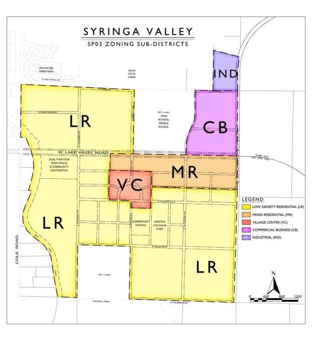
37 08/30/17 SUB
38 08/30/17 SUB
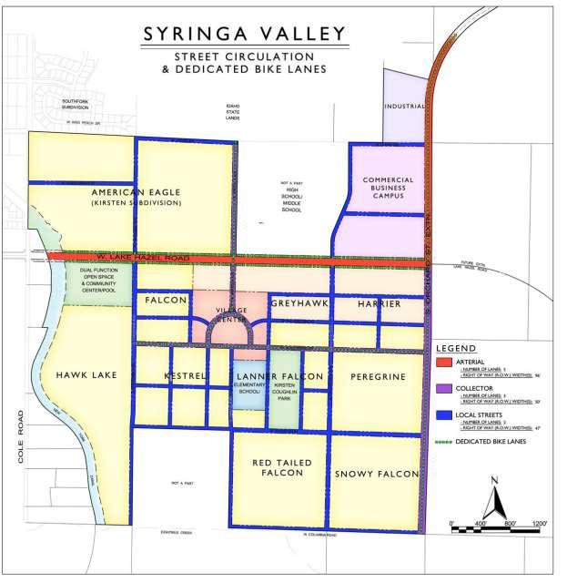
39 08/30/17 SUB
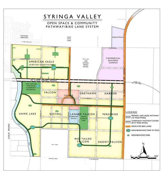
40 08/30/17 SUB
41 September 1, 2017 Project #: Corey Barton Homes, Inc. C/O Bob Taunton Taunton Group 2724 S. Palmatier Way Boise, ID RE: Syringa Valley Traffic Review of Phase 1 Relocated from the Kirsten Subdivision to the Barnwood District Subdivision - Boise, Idaho Dear Bob, This letter presents the results of the transportation evaluation for changing the location of the initial residential development from the approved Kirsten Subdivision, located in the northwest quadrant of the Syringa Valley Development, to the Barnwood District Subdivision to be located in the southwest quadrant of the development. The proposed development plan for the Barnwood District Subdivision includes approximately 454 housing units in the Hawk Lake development area south of Lake Hazel Road, which will include 64 townhomes and 390 single family homes. This would replace the 452 housing units approved for the Kirsten Subdivision on the north side of Lake Hazel Road, which included 40 townhomes and 412 single family homes. This study addresses the following key items: Evaluation of the site traffic projected to use S Cole Road with the change to the proposed development location and number of lots. Threshold analysis to identify the timing for a secondary connection to Lake Hazel Road from the new subdivision. Evaluation of the traffic operations and the need for turn lanes at the Barnwood Avenue (formerly shown as Cheyenne Avenue)/Lake Hazel Boulevard intersection. Conclusions and recommendations. BACKGROUND In November, 2016, the City of Boise approved the Kirsten Subdivision, which included approximately 412 single family homes and 40 condominium/townhome units. The Kirsten Subdivision included access to S Cole Road and Lake Hazel Road. The City required that no more than 12 occupancy permits at the Kirsten Subdivision be approved prior to completing the Lake-Hazel Road and Orchard Street extensions, such that site traffic access would not be limited to Cole Road.


42 Syringa Valley Barnwood District Evaluation Project #: September 1, 2017 Page: 2 Based an updated review of the development phasing, Cory Barton Homes determined the best phasing approach is to shift the majority of the first phase of the development near the proposed community center in the area to the south of Lake Hazel Road and to the east of the New York Canal. The new plat, named Barnwood District, would include the Hawk Lake development area as well as portions of the Falcon and Kestrel Development areas. Figure 1 shows the Syringa Valley Development Conceptual Master Plan with the location of the approved Kirsten Subdivision and the proposed Barnwood District Subdivision identified. Figure 2 illustrates the proposed site plan. Kirsten Subdivision (Previously Approved with 452 Units) Proposed Subdivision with 454 Units Figure 1. Master Plan with Kirsten and Proposed New Plat IMPACT TO TRAFFIC ON S COLE ROAD Based on a comparison of the development locations, and the City requirement that the development provide the Lake Hazel Road and Orchard Road extensions, the impact on S Cole Road is estimated to be similar with respect to the percentage of traffic that will utilize S Cole Road. Therefore, the primary factor that would impact the site traffic impact on S Cole Road is the trip generation of the development. Lake Hazel Road New ¼ mi Collector Street (Barnwood Ave) Figure 2. Proposed Site Plan for the Barnwood District Subdivision Kittelson & Associates, Inc. Boise, Idaho
43 Syringa Valley Barnwood District Evaluation Project #: September 1, 2017 Page: 3 Table 1 shows a trip generation comparison between the Kirsten Subdivision and the new proposed Barnwood District Subdivision. Table 1: Phase 1 Trip Generation Comparison Land Use ITE Code Size Daily Approved Kirsten Subdivision Weekday AM Peak Hour Weekday PM Peak Hour Total In Out Total In Out Single Family Residential Units 3, Condominium/Townhome Units Kirsten Total Trips 4, Proposed New Phase 1 Barnwood District Subdivision Buildout Proposal Single Family Residential Units 3, Condominium/Townhome Units New Subdivision Total 4, Net Difference As shown in Table 1, the change in the development location for the initial phase of the Syringa Valley development results in approximately 51 less daily trips and a decrease of approximately 5 to 6 weekday peak hour trips With the extension of both Lake Hazel Road and Orchard Street required as part of the initial phase of buildout, the traffic from the site is projected to utilize three primary roadways for access to the development which include S Cole Road, Orchard Street/Gowen Road, and Lake Hazel Road. Table 2 shows the estimated distribution of the difference in trips to the external roadways. Table 2: Distribution of the Difference in Trips between Phase 1 Subdivisions Land Use Trip Percentage Daily Trip Difference AM Peak Hour Trip Difference PM Peak Hour Trip Difference S. Cole Road 22% Lake Hazel Road 28% Orchard Street/Gowen Road 50% As shown in Table 2, the net impact on the S Cole Road corridor is approximately 1 trip during the weekday a.m and p.m. peak hours and 11 daily trips. This change is not significant and therefore the proposed change in the subdivision location will not have a significant impact on S Cole Road. TIMING FOR A SECOND ACCESS TO LAKE HAZEL ROAD One potential issue that is relevant to the new proposal plat is that the area will be served by only one public street connection to Lake Hazel Road. While there are other accesses to Lake Hazel Road Kittelson & Associates, Inc. Boise, Idaho
44 Syringa Valley Barnwood District Evaluation Project #: September 1, 2017 Page: 4 at 1/4 mile spacing, they will not be completed in the first subdivision. Section of the ACHD Policy Manual states the following: If a proposed development only has one access to a public street that is classified as a collector, or if it proposes to extend public streets from an existing development with only one collector street access to the public street system, the maximum forecast ADT to be allowed at any point on the collector street is 3,000. This volume may be reduced or increased based on information received from the lead land use agency, the applicable fire department, and/or emergency services. The District will also take into consideration the following items when determining whether or not to reduce or increase the maximum allowable ADT: railroad crossings, canal crossings, and topography (foothills vs. flat land). Based on the 3,000 ADT threshold, approximately 315 single family homes can be built and occupied for the new plat area prior to exceeding the ACHD policy threshold. Therefore, at approximately 315 homes, a secondary connection to Lake Hazel Road will be required or ACHD will need to grant an exception to their policy. The secondary access could be a planned street connection through a future plat to the east or a temporary access to Lake Hazel Road. OPERATIONS & TURN LANE ANALYSIS AT LAKE HAZEL ACCESS Based on an evaluation of the buildout of the proposed new Barnwood District Subdivision with an interim full access to Lake Hazel Road at Barnwood Avenue, the intersection level of service and ACHD turn lane warrants were evaluated. Traffic volumes were estimated based on a buildout year of the Barnwood District Subdivision of approximately This assumes that Lake Hazel Road is only two lanes (one through lane in each direction) and only the Barnwood subdivision is built-out. Table 3 shows the results of the level of service analysis. Table Total Traffic Intersection Operations - Lake Hazel Road/Barnwood Avenue Intersection Lake Hazel Rd/Barnwood Ave Intersection Control 1 Intersection AM (PM) AM Peak Hour PM Peak Hour V/C 1 LOS 2 Delay 3 Lane Group V/C 1 LOS 2 Delay 3 V/C 1 LOS 2 Delay 3 TWSC N/A N/A N/A EBL 0.01 A A 7.9 WBL 0.03 A A 8.4 NBLTR 0.50 C C 24.7 SBLTR 0.04 B C 19.2 Notes: 1 TWSC = Two-Way Stop Control intersection, ASWC = All-Way Stop Controlled intersection; 2 V/C Ratio is defined as vehicle-to-capacity ratio which calculates the number of vehicles divided by the capacity of the roadway/intersection during the peak 15 minutes of the peak hour; 5 LOS = Level of Service; 4 Delay is reported as average delay in seconds per vehicle; and Bold and italics and highlighted cells indicate an intersection and/or lane group operating below its jurisdiction s standards. As shown in Table 3, the intersection movements are below capacity and the critical northbound side street approach on Barnwood Avenue operates at an acceptable LOS C. The turn lane evaluation analyzed the need for a westbound left-turn lane and eastbound right-turn lane on Lake Hazel Road and assumed a posted speed of 40 mph on Lake Hazel Road. Table 4 shows the results of the turn lane evaluation. Kittelson & Associates, Inc. Boise, Idaho
45
46 Syringa Valley Barnwood District Evaluation Project #: September 1, 2017 Page: 6 ATTACHMENTS Trip Generation Computations Projected 2025 Turning Movement at Barnwood Avenue/Lake Hazel Road Average Daily Traffic Calculation at Barnwood Avenue Level of Service and Turn Lane Evaluation Worksheets Kittelson & Associates, Inc. Boise, Idaho

47 Trip Generation Comparison Original Trip Generation Phase 1 (with Connection to Orchard/Gowen) Kirsten Sub - Trip Generation Based on Revised Plat Weekday AM Weekday PM ITE Code Size Daily Trips Total In Out Total In Out Single Family Residential Condominium/Townhome Total Note that Equation was not used for townhomes since internal trips between uses is not calculated and townhomes are part of a larger overall larger number of residential units that is over the average in the ITE manual. Plat #2 - Trip Generation Weekday AM Weekday PM ITE Code Size Daily Trips Total In Out Total In Out Kirsten - Single Family Residential 0.0 Condominium/Townhome Single Family Residential Total Net Difference
Committed to Service
 Development Services Department Committed to Service January 19, 2016 TO: FROM: SUBJECT: ACHD Board of Commissioners Mindy Wallace, AICP Planner III Kirsten Subdivision/BPP15-0023 Executive Summary: The
BPP / SUB
 Development Services Department Project/File: Lead Agency: Site address: Millwell Place Subdivision/ BPP15-0031/ SUB15-0064 This is a preliminary plat application to allow for the development of 68 building
 Development Services Department Project/File: Lead Agency: Site address: Fall Creek Subdivision (MPP-12-016) This is a preliminary plat application to subdivision approximately 110 acres into 296 residential
 Development Services Department Project/File: Lead Agency: Site address: Applicant: Memory Ranch / KPP15-0003 / 15-02-AN / 15-01-S The applicant is requesting annexation of approximately 10 acres, rezoning
ACHD Board of Commissioners Stacey Yarrington, Planner III Tandem Ridge/ EPP / PP-07-16/ RZ-12-16/ CPA-01-16/ A-07-16
 Development Services Department DATE: December 14, 2016 TO: FROM: SUBJECT: ACHD Board of Commissioners Stacey Yarrington, Planner III Tandem Ridge/ EPP16-0012/ PP-07-16/ Executive Summary: This is an annexation,
Committed to Service. Development Services. February 21, ACHD Commission. Mindy Wallace, AICP
 Committed to Service Sara M. Baker, President Rebecca W. Arnold, Vice President Jim D. Hansen, Commissioner Kent Goldthorpe, Commissioner Paul Woods, Commissioner February 21, 2018 Development Services
Committed to Service
 Development Services Department Committed to Service TO: FROM: Ada County Highway District Commissioners Mindy Wallace, AICP Planner III COMISSION HEARING: January 27, 2016 SUBJECT: Syringa Valley Specific
Development Services Department
 Kent Goldthorpe, President Paul Woods, Vice President Rebecca W. Arnold, Commissioner Sara M. Baker, Commissioner Jim D. Hansen, Commissioner July 21, 2016 Development Services Department To: From: ACHD
Committed to Service
 Committed to Service Kent Goldthorpe, President Paul Woods, Vice President Rebecca W. Arnold, Commissioner Sara M. Baker, Commissioner Jim D. Hansen, Commissioner May 24, 2017 Development Services TO:
 Development Services Department Project/File: Lead Agency: Site address: Aralar Park/SUB13-00048 This is a preliminary plat application to construct 55 buildable lots and 6 common lots on 12.67 acres.
Committed to Service
 Committed to Service Sara M. Baker, President Rebecca W. Arnold, Vice President Jim D. Hansen, Commissioner Kent Goldthorpe, Commissioner Paul Woods, Commissioner February 21, 2018 Development Services
BPP / SUB /CAR /PUD
 Development Services Department Project/File: Lead Agency: Site address: Roe Street Townhomes/ BPP16-0023/ SUB16-00046/CAR16-00023/PUD16-00022 This is a rezone, preliminary plat, and planned unit development
BOI / DRH S. 13 th Street Mixed use office/retail development with residential dormitory
 Jim D. Hansen, President Sara M. Baker, Vice President Rebecca W. Arnold, Commissioner Kent Goldthorpe, Commissioner Paul Woods, Commissioner October 21, 2015 To: Rick Nesser ISS River Partners, LLC 8312
Development Services Department
 Kent Goldthorpe, President Paul Woods, Vice President Rebecca W. Arnold, Commissioner Sara M. Baker, Commissioner Jim D. Hansen, Commissioner July 28, 2016 Development Services Department To: From: ACHD
Development Services Department
 Development Services Department Project/File: Lead Agency: Site address: Harris Ranch Specific Area Plan Text Amendments/ZOA14-00001 The applicant is requesting approval of a text amendment application
Roadway Classification Design Standards and Policies. Pueblo, Colorado November, 2004
 Roadway Classification Design Standards and Policies Pueblo, Colorado November, 2004 Table of Contents Page Chapter 1. General Provisions 1.1 Jurisdiction 3 1.2 Purpose and Intent 3 1.3 Modification 3
2. Caven Ridge Estates Subdivision No. 1 adds 0.54 centerline miles to the ACHD roadway system.
 Kent Goldthorpe, President Paul Woods, Vice President Rebecca W. Arnold, Commissioner Sara M. Baker, Commissioner Jim D. Hansen, Commissioner October 12, 2016 Development Services Department To: From:
Committed to Service
 Development Services Department Committed to Service June 30, 2014 TO: FROM: SUBJECT: ACHD Board of Commissioners Christy Little Planning Review Supervisor Victory Middle School/MCUP-14-003 DATE: July
SECTION 3 STREET DESIGN
 3.01 GENERAL SECTION 3 STREET DESIGN For purposes of geometric and structural design, streets shall be classified according to the following table. The City Engineer will determine the class of all proposed
This Chapter sets forth the minimum design, technical criteria and specifications to be used in the preparation of all roadway plans.
 4.1 GENERAL This Chapter sets forth the minimum design, technical criteria and specifications to be used in the preparation of all roadway plans. These Roadway Standards are for new construction and modification
Committed to Service
 Committed to Service Paul Woods, President Rebecca W. Arnold, Vice President Sara M. Baker, Commissioner Jim D. Hansen, Commissioner Kent Goldthorpe, Commissioner January 16, 2018 Development Services
Subdivision Staff Report
 Subdivision Staff Report Subdivision Name Plano Road Subdivision File Number SUB07-00065 Approval Preliminary Plat Lead Agency Boise City Annexation Date Pending (CAR07-00042/DA) Comp. Plan Does Not Comply
5.0 Roadway System Plan
 Southwest Boise Transportation Study Page 16 5.0 Roadway System Plan The Roadway System Plan outlines roadway improvements in the Initial Study Area. It forecasts future deficiencies on the arterial system,
Town of Siler City - Unified Development Ordinance ARTICLE XIV - Streets and Sidewalks
 ARTICLE XIV - Streets and Sidewalks 193 Street Classification (a) In all new subdivisions, streets that are dedicated to public use shall be classified as provided in 193(b) (1) The classification shall
T A B L E OF C O N T E N T S
 T A B L E OF C O N T E N T S PART III SUBDIVISION REGULATIONS OF THE DEPARTMENT OF PUBLIC WORKS, C & C D PAGE PAGE Responsibility for Development of Streets......... 29 Right-of-Way Widths...... 37 Purpose...........
2. The applicant is Corey Barton Homes, Inc. and the principal for the applicant is Corey D. Barton, President.
 Kent Goldthorpe, President Paul Woods, Vice President Rebecca W. Arnold, Commissioner Sara M. Baker, Commissioner Jim D. Hansen, Commissioner February 25, 2016 Development Services Department To: ACHD
Access requests to County streets and roadways are processed through one of the following methods:
 13.1 GENERAL APPLICATION PROCESS Access requests to County streets and roadways are processed through one of the following methods: A. Planned Developments may set general locations for access points.
Recommended Roadway Plan Section 2 - Land Development and Roadway Access
 Recommended Roadway Plan Section 2 - Land Development and Roadway Access SECTION 2 Land Development and Roadway Access 2.1 Land Use and Access Management The Federal Highway Administration (FHWA) defines
Classification Criteria
 SCHEDULE D TO RECOMMENDED OFFICIAL PLAN AMENDMENT NO. 40 SCHEDULE C-4 Road Criteria Criteria Traffic Service Objective Land Service/Access Typical Daily Traffic Volume Flow characteristics Travel Speed
4APNOIPF Vh, YII PTC CITY COUNCIL AGENDA REPORT. Honorable Mayor and City Council Members. 8K TH 63 River Crossing Bridge Replacement Project
 City of RE 4APNOIPF Vh, X` W\ YII PTC ING, CITY COUNCIL AGENDA REPORT Council Meeting Date: September 26, 2016 To: From: Agenda Item: Honorable Mayor and City Council Members Ron Rosenthal, Engineering
RZC Appendix 8A Marymoor Subarea Street Requirements
 RZC Appendix 8A Marymoor Subarea Street Requirements For additional design details for Marymoor Subarea infrastructure, refer to the 2017 Marymoor Subarea Infrastructure Planning Report. STREET REQUIREMENTS
Clackamas County Comprehensive Plan
 ROADWAYS The County s road system permits the movement of goods and people between communities and regions, using any of a variety of modes of travel. Roads provide access to virtually all property. They
WYDOT DESIGN GUIDES. Guide for. Non-NHS State Highways
 WYDOT DESIGN GUIDES Guide for Non-NHS State Highways 2014 GUIDE FOR Non-NATIONAL HIGHWAY SYSTEM (Non-NHS) STATE HIGHWAYS PRESERVATION REHABILITATION RECONSTRUCTION INTRODUCTION This Guide is directed to
Poor pavement condition Substandard Intersections. / Substandard bike/pedestrian/transit accommodations. Driveway access Environmental concerns
 Public Informational Meeting University Avenue (Allen Boulevard Segoe Road) March 23, 2011 City of Madison City of Middleton Village of Shorewood Hills Dane County Existing Roadway Conditions Poor pavement
WYDOT DESIGN GUIDES. Guide for. NHS Arterial (Non-Interstate)
") WYDOT DESIGN GUIDES Guide for NHS Arterial (Non-Interstate) 2014 GUIDE FOR NATIONAL HIGHWAY SYSTEM (NHS) HIGHWAYS (NHS ARTERIALS, Non-Interstate) PRESERVATION REHABILITATION RECONSTRUCTION INTRODUCTION
WYDOT DESIGN GUIDES Guide for NHS Arterial (Non-Interstate) 2014 GUIDE FOR NATIONAL HIGHWAY SYSTEM (NHS) HIGHWAYS (NHS ARTERIALS, Non-Interstate) PRESERVATION REHABILITATION RECONSTRUCTION INTRODUCTION
This chapter describes the proposed circulation system and transportation alternatives associated with
 5.0 Circulation 5.1 OVERVIEW This chapter describes the proposed circulation system and transportation alternatives associated with West Landing, and summarize the information contained in the Existing
5 CIRCULATION AND STREET DESIGN
 5 CIRCULATION AND STREET DESIGN This chapter describes circulation and streetscape improvements proposed for the Northwest Chico Specific Plan Area. It includes detailed design specifications for existing
M-58 HIGHWAY ACCESS MANAGEMENT STUDY Mullen Road to Bel-Ray Boulevard. Prepared for CITY OF BELTON. May 2016
 M-58 HIGHWAY ACCESS MANAGEMENT STUDY Prepared for CITY OF BELTON By May 2016 Introduction Missouri State Highway 58 (M-58 Highway) is a major commercial corridor in the City of Belton. As development has
Provides an extension of a road to the subdivision boundary or parcel to facilitate the continuity of possible adjacent development.
 SECTION 2 - ROADWAYS 2-1 Continuity of the Public Road System The continuity of a publicly maintained system is a prerequisite to the addition of any street into the County road system. A road or street
Street Paving and Sidewalk Policy
 City Commission Policy 600 Street Paving and Sidewalk Policy DEPARTMENT: Public Works DATE ADOPTED: June 7, 1995 DATE OF LAST REVISION: December 10, 2014 Policy No. 600.01 AUTHORITY: PASS City of Tallahassee-Leon
Review and Comment ACHD s FY Five Year Work Program Draft for Adoption
 Date: January 5, 2006 To: From: Mayor and City Council Karen Gallagher Planning and Development Services Meeting: January 10, 2006 Re: Review and Comment ACHD s FY 2007-2011Five Year Work Program Draft
APPENDIX G: INTERSECTION NEEDS AT OKEECHOBEE BOULEVARD
 APPENDIX G: INTERSECTION NEEDS AT OKEECHOBEE BOULEVARD INTERSECTION NEEDS AT SR 7 and OKEECHOBEE BOULEVARD SR 7 Extension Project Development and Environment (PD&E) Study From Okeechobee Boulevard (SR
CURBSIDE ACTIVITY DESIGN
 5 CURBSIDE ACTIVITY DESIGN This chapter provides design guidance for separated bike lanes adjacent to curbside activities including parking, loading and bus stops. Typical configurations are presented
December 2, ACHD Board of Commissioners. Lauren Watsek Planner I. PUD (Deep Green Condominiums) Executive Summary:
 Executive Summary:") Development Services Department December 2, 2013 TO: FROM: SUBJECT: ACHD Board of Commissioners Lauren Watsek Planner I PUD13-00013 (Deep Green Condominiums) Executive Summary: The applicant is requesting
Development Services Department December 2, 2013 TO: FROM: SUBJECT: ACHD Board of Commissioners Lauren Watsek Planner I PUD13-00013 (Deep Green Condominiums) Executive Summary: The applicant is requesting
CHAPTER 16 PEDESTRIAN FACILITIES DESIGN AND TECHNICAL CRITERIA TABLE OF CONTENTS
 CHAPTER 16 PEDESTRIAN FACILITIES DESIGN AND TECHNICAL CRITERIA TABLE OF CONTENTS Section Title Page 16.1 General... 16-1 16.1.1 AASHTO Reference... 16-1 16.1.2 ADA Requirements... 16-1 16.2 Sidewalks...
Committed to Service
 Development Services Department Committed to Service November 4, 2014 TO: FROM: SUBJECT: ACHD Board of Commissioners Mindy Wallace, AICP Planner III Village Charter School/ BOI14-0105/CUP14-00046/DRH14-000324
Off-road Trails. Guidance
 Off-road Trails Off-road trails are shared use paths located on an independent alignment that provide two-way travel for people walking, bicycling, and other non-motorized users. Trails specifically along
5.0 ROADWAY DESIGN 5.1 INTRODUCTION
 SECTION 5 5.0 ROADWAY DESIGN 5.1 INTRODUCTION In the design of roadways, it is essential to account for all the components that may affect the efficiency and safety of the roadway network. The four (4)
County of Greenville South Carolina. Traffic Calming Program Neighborhood Traffic Education Program and Speed Hump Program
 County of Greenville South Carolina Traffic Calming Program Neighborhood Traffic Education Program and Speed Hump Program (rev) August 2008 I. PURPOSE The potential negative impacts from vehicular traffic
9.1 FUNCTIONAL HIGHWAY SYSTEMS IN URBANIZED AREAS Principal Arterial Interstate Principal Arterial Non-Interstate
 Greater Bozeman Area Transportation Plan (2007 Update) Chapter 9: Recommended Major Street Network & Roadway Typical Sections 9.1 FUNCTIONAL HIGHWAY SYSTEMS IN URBANIZED AREAS The discussion in this Chapter
Chapter 4: Funding and Implementation
 Chapter 4: Funding and Implementation 83 84 Cost Estimating Cost estimating is an iterative process. When a project is in the conceptual stage, preliminary cost estimates are also provided conceptually,
INDEX. Geometric Design Guide for Canadian Roads INDEX
 Acceleration lane, see Lanes, Acceleration Access, 8.1 Access Management and Functional Classification 8.2 Access Management by Design Classification 8.3 Access Configuration 8.4 Building Set-Back Guidelines
State Street and Pierce Park Lane Intersection Concept Report
 State Street and Pierce Park Lane Intersection Prepared for September 2017 Prepared by CITATION Parametrix. 2017. State Street & Pierce Park Lane Intersection. Prepared by Parametrix, Boise, ID. September
This page intentionally left blank.
 This page intentionally left blank. COMMUNITY Coweta Community Overview Coweta Coweta, a residential community located in Wagoner County, is a suburb of Tulsa situated southeast of the metropolitan area
Appendix T CCMP TRAIL TRAFFIC & TRANSPORTATION DESIGN STANDARD
 Appendix T CCMP 3.3.4 TRAIL TRAFFIC & TRANSPORTATION DESIGN STANDARD 3.3.4 Trail Traffic and Transportation Design Multi-use trails have certain design standards, which vary depending on the agency that
DRAFT - CITY OF MEDFORD TRANSPORTATION SYSTEM PLAN Roadway Cross-Sections
 Roadway Cross-Sections Medford s roadway cross-section standards apply to new and reconstructed roads. The crosssections take into consideration roadway function and operational characteristics, including
4.0 ACCESS CONTROL PLAN - SH 14 (JEFFERSON STREET/RIVERSIDE AVENUE)
") 4.1 Existing Conditions Roadway Physical Characteristics Typical Sections Jefferson Street 4.0 ACCESS CONTROL PLAN - SH 14 (JEFFERSON STREET/RIVERSIDE AVENUE) The existing typical cross-section for SH
4.1 Existing Conditions Roadway Physical Characteristics Typical Sections Jefferson Street 4.0 ACCESS CONTROL PLAN - SH 14 (JEFFERSON STREET/RIVERSIDE AVENUE) The existing typical cross-section for SH
4. ENVIRONMENTAL IMPACT ANALYSIS 9. TRANSPORTATION AND TRAFFIC
 4. ENVIRONMENTAL IMPACT ANALYSIS 9. TRANSPORTATION AND TRAFFIC 4.9.1 INTRODUCTION The following section addresses the Proposed Project s impact on transportation and traffic based on the Traffic Study
INTRODUCTION THOROUGHFARE SYSTEM CLASSIFICATIONS
 INTRODUCTION The thoroughfare plan will assist public officials in the development of a specialized system for efficient and safe movement of vehicular traffic while minimizing potential conflicts with
Summary: Mercer County Princeton Avenue & Spruce Street Study January 2009
 Summary: Several recent studies have assessed potential development and redevelopment opportunities in the Mercer Crossing area of Trenton, Ewing, and Lawrence. This Princeton Avenue and Spruce Street
GWINNETT COUNTY DEPARTMENT OF TRANSPORTATION
 GWINNETT COUNTY DEPARTMENT OF TRANSPORTATION 1 of 7 June 20, 2007 GENERAL: The following guidelines shall be used in the determination of the requirement for left turn lanes for development projects and
Complete Streets Policy DAVID CRONIN, P.E., CITY ENGINEER
 Complete Streets Policy DAVID CRONIN, P.E., CITY ENGINEER Complete Streets City Commission adopted a Complete Streets policy in 2012 Complete Streets are road networks that are designed for all users:
Geometric Design Tables
 Design Manual Chapter 5 - Roadway Design 5C - Geometric Design Criteria 5C-1 Geometric Design Tables A. General The following sections present two sets of design criteria tables - Preferred Roadway Elements
City of Wayzata Comprehensive Plan 2030 Transportation Chapter: Appendix A
 A1. Functional Classification Table A-1 illustrates the Metropolitan Council s detailed criteria established for the functional classification of roadways within the Twin Cities Metropolitan Area. Table
Corpus Christi Metropolitan Transportation Plan Fiscal Year Introduction:
 Introduction: The Safe, Accountable, Flexible, Efficient Transportation Equity Act: A Legacy for Users (SAFETEA-LU) has continued the efforts started through the Intermodal Surface Transportation Efficiency
DESIGN MEMORANDUM WITH DESIGN EXCEPTIONS SP SP
 DRAFT NOT FINAL (Note: document was not finalized due to an eastbound stopping site distance design issue that requires more detailed bridge and roadway design considerations. This discussion starts on
SECTION 1 - TRAFFIC PLANNING
 SECTION 1 - TRAFFIC PLANNING 1.1 TRAFFIC OPERATIONS 1.1.1 Roadway Functional Classification The Multnomah County Comprehensive Framework Plan s Policy 34: Trafficways and the Functional Classification
MAJOR THOROUGHFARE PLAN
 MAJOR THOROUGHFARE PLAN Adopted by City Commission On November 21, 2005 Per Resolution No. 4420 Amendment to the Comprehensive Community Development Plan City of Hobbs City of Hobbs MAJOR THOROUGHFARE
Driveway Design Criteria
 Design Manual Chapter 5 - Roadway Design 5L - Access Management 5L-4 Driveway Design Criteria A. General For efficient and safe operations, access drives and minor public street intersections can be improved
CONNECTIVITY PLAN. Adopted December 5, 2017 City of Virginia Beach
 CONNECTIVITY PLAN Adopted December 5, 2017 City of Virginia Beach CONTENTS 1.0 Background & Purpose... 2 2.0 Existing Inventory & Analysis... 3 ViBe District Existing Walking Conditions... 4 3.0 ViBe District
Chapter 2: Standards for Access, Non-Motorized, and Transit
 Standards for Access, Non-Motorized, and Transit Chapter 2: Standards for Access, Non-Motorized, and Transit The Washtenaw County Access Management Plan was developed based on the analysis of existing
9 Leeming Drive Redevelopment Ottawa, ON Transportation Brief. Prepared By: Stantec Consulting Ltd.
 9 Leeming Drive Redevelopment Ottawa, ON Transportation Brief Prepared By: Stantec Consulting Ltd. TIA GUIDELINES CHECKLIST Report Context Municipal Address Comment: Section 1.1 Location relative to major
11/28/2016 VIA
 11/28/2016 VIA EMAIL Ethan Meltzer, Assistant Planner City of Sacramento Community Development Department 300 Richards Blvd., 3 rd Floor Sacramento, Ca 95811 RE: Natomas Corporate Center Commercial Building
Committed to Service
 Committed to Service Sherry R. Huber, President Rebecca W. Arnold, Vice President John S. Franden, Commissioner Carol A. McKee, Commissioner Sara M. Baker, Commissioner To: From: ACHD Commissioners, Director,
Section 7 Complete Green Street Guidelines DRAFT
 Section 7 Complete Green Street Guidelines DRAFT 1 Section: 7.0 COMPLETE GREEN STREET GUIDELINES These guidelines serve as options to mitigate the environmental impact of a project as well as guide the
MOUNTAIN HOUSE SPECIFIC PLAN I 9.1 INTRODUCTION ASSUMPTIONS TRANSPORTATION FACILITIES TRANSPORTATION IMPROVEMENTS PHASING 9.
 CHAPTER NINE: TRANSPORTATION AND CIRCULATION 9.1 INTRODUCTION 9.1 9.2 ASSUMPTIONS 9.1 9.3 TRANSPORTATION FACILITIES 9.1 9.4 TRANSPORTATION IMPROVEMENTS PHASING 9.3 LIST OF FIGURES LIST OF TABLES Figure
DUNBOW ROAD FUNCTIONAL PLANNING
 DUNBOW ROAD FUNCTIONAL PLANNING Final Report August 3, 216 #31, 316 5th Avenue NE Calgary, AB T2A 6K4 Phone: 43.273.91 Fax: 43.273.344 wattconsultinggroup.com Dunbow Road Functional Planning Final Report
REMOVE BARRIERS TO, ENCOURAGE CREATION OF AND PROVIDE GUIDELINES FOR SAFE ROUTES (ALL DISTRICTS)
") Ordinance 2009-98 AN ORDINANCE OF THE BOARD OF SUPERVISORS OF PIMA COUNTY, ARIZONA; RELATING TO ZONING; AMENDING THE PIMA COUNTY ZONING CODE TITLE 18 BY AMENDING SECTION 18.03.020 (DEFINITIONS) TO ADD
Ordinance 2009-98 AN ORDINANCE OF THE BOARD OF SUPERVISORS OF PIMA COUNTY, ARIZONA; RELATING TO ZONING; AMENDING THE PIMA COUNTY ZONING CODE TITLE 18 BY AMENDING SECTION 18.03.020 (DEFINITIONS) TO ADD
Access Management Standards
 Access Management Standards Section 1: Application of Access Standards This chapter describes the Department's access management standards for access connections on the county roadway system. The standards
Central Arkansas Regional Transportation Study Area ROADWAY DESIGN STANDARDS And Implementation Procedures
 Central Arkansas Regional Transportation Study Area ROADWAY DESIGN STANDARDS And Implementation Procedures These standards have been prepared for the use of all jurisdictions to incorporate into their
Route 47 (North Main Street) Reconstruction
 Reconstruction") TOWN OF SUNDERLAND Route 47 (North Main Street) Reconstruction Presented by Lou Rabito, P.E. Presented to Town of Sunderland June 11, 2018 Project Overview MassDOT Project No. 607245 Resurfacing and Related
TOWN OF SUNDERLAND Route 47 (North Main Street) Reconstruction Presented by Lou Rabito, P.E. Presented to Town of Sunderland June 11, 2018 Project Overview MassDOT Project No. 607245 Resurfacing and Related
POLICY REVIEW SUMMARY
 E POLICY REVIEW SUMMARY The project team reviewed planning and design standards for each community in the region. The following tables summarize the relevant code in these documents that pertains to the
Urban Planning and Land Use
 Urban Planning and Land Use 701 North 7 th Street, Room 423 Phone: (913) 573-5750 Kansas City, Kansas 66101 Fax: (913) 573-5796 Email: planninginfo@wycokck.org www.wycokck.org/planning To: From: City Planning
Access Location, Spacing, Turn Lanes, and Medians
 Design Manual Chapter 5 - Roadway Design 5L - Access Management 5L-3 Access Location, Spacing, Turn Lanes, and Medians This section addresses access location, spacing, turn lane and median needs, including
REGIONAL BICYCLE AND PEDESTRIAN DESIGN GUIDELINES
 REGIONAL BICYCLE AND PEDESTRIAN DESIGN GUIDELINES November 16, 2011 Deb Humphreys North Central Texas Council of Governments Bicycle and Pedestrian Advisory Committee Snapshot of the Guide 1. Introduction
Houma-Thibodaux Metropolitan Planning Organization STP<200K Funding Application APPLICATION
 APPLICATION HOUMA-THIBODAUX METROPOLITAN PLANNING ORGANIZATION (HTMPO) FOR SURFACE TRANSPORTATION PROGRAM (STP
General Design Factors
 Chapter 3: 3-1.0 Introduction General Design Factors Mn/DOT s goals include encouraging and accommodating safe bicycling. From a design perspective, these goals are achieved by first having an understanding
Project Update May 2018
 Project Update May 2018 Dakota County, in cooperation with the City of Lakeville, is planning to reconstruct 202 nd Street West (County Road 50) from Holyoke Avenue to Cedar Avenue (County Road 23). 202
West Dimond Blvd Upgrade Jodhpur Street to Sand Lake Road
 West Dimond Blvd Jodhpur St to Sand Lake CSS Transportation Project Summary Municipality of Anchorage Project # 05 005 Project Manager: John Smith, P.E. (MOA PM&E) Project Administrator: Julie Makela,
Multimodal Through Corridors and Placemaking Corridors
 68 Multimodal Through Corridors and Placemaking Corridors Corridors have different functions in a region. Some corridors are used to get smoothly and rapidly through a region or to get quickly to major
Chapter Five: Transportation Plan
 Introduction Transportation and Circulation Street Sections Intersections Traffic Calming Public Transit Trails Public Landscape and Streetscape Circulation Policies September 2008 Page 5-1 Tidewater Crossing
Peer Review of Highlands Neighborhood Traffic and Pedestrian Safety Plan
 FINAL REPORT March 14, 2017 Prepared for: Ada County Highway District Prepared by: SIX MILE ENGINEERING, PA Executive Summary The (Highlands Safety Plan) developed by the Ada County Highway District (ACHD)
11/3/2017 VIA . RE: River Oaks Phase 2 (P17-051)
") 11/3/2017 VIA EMAIL Ethan Meltzer, Assistant Planner City of Sacramento Community Development Department 300 Richards Blvd., 3 rd Floor Sacramento, CA 98811 RE: River Oaks Phase 2 (P17-051) Dear Mr. Meltzer:
11/3/2017 VIA EMAIL Ethan Meltzer, Assistant Planner City of Sacramento Community Development Department 300 Richards Blvd., 3 rd Floor Sacramento, CA 98811 RE: River Oaks Phase 2 (P17-051) Dear Mr. Meltzer:
Atwood Avenue Fair Oaks Avenue Cottage Grove Road
 Atwood Avenue Fair Oaks Avenue Cottage Grove Road Agenda Purpose Review project scope & goals Present design alternatives Gather feedback Answer Questions Format Open House Presentation Q&A Open House
CITY OF LUCAS 2014 MASTER THOROUGHFARE PLAN
 INTRODUCTION CITY OF LUCAS 2014 MASTER THOROUGHFARE PLAN A thoroughfare system is intended to provide an effective means of moving vehicles within and through a city. The thoroughfare plan will assist
Exhibit B: Proposed amendments to the Transportation Element of the Oakland Comprehensive Plan
 Exhibit B: Proposed amendments to the Transportation Element of the Oakland Comprehensive Plan TRANSPORTATION Introduction An important aspect of any community is its transportation system, the means by
GEOMETRIC DESIGN STANDARDS FOR NEW RESIDENTIAL SUBDIVISION STREETS TABLE 1A CG-6 CURB AND GUTTER SECTION
 TABLE 1A CG-6 CURB AND GUTTER SECTION HORIZONTAL AND VERTICAL CONTROLS CURB AND GUTTER ROADWAYS MAXIMUM 3:1 CUT OR FILL SLOPE CURVE DATA MIN. SIGHT DISTANCE PROJECTED TRAFFIC VOLUME (ADT) MIN. DESIGN SPEED
Citizens Handbook for Requesting Traffic Calming Devices
 Citizens Handbook for Requesting Traffic Calming Devices January 19, 2015 Table of Contents 1. PURPOSE... - 1-2. DEFINITIONS... - 2-3. GENERAL INFORMATION... - 3-3.1. ELIGIBILITY REQUIREMENTS... - 3-3.2.
PROJECT NO. 093 MA 199 H C. FEDERAL NO. xxxx WIKIEUP-WICKENBURG-PHOENIX HIGHWAY TEGNER STREET, ALTERNATIVE 10 PROJECT IMPROVEMENT
 PROJECT NO. 093 MA 199 H 5807 01C FEDERAL NO. xxxx WIKIEUP-WICKENBURG-PHOENI HIGHWAY TEGNER STREET, ALTERNATIVE 10 PROJECT IMPROVEMENT (INTERSECTION IMPROVEMENT) US 93/US 60 FINAL PROJECT ASSESSMENT April
Zlatko Krstulich, P.Eng. City of O9awa
 Zlatko Krstulich, P.Eng. City of O9awa 1. Introduction to the Ontario Traffic Manual Series 2. What is OTM Book 18: Bicycle Facilities? 3. Study / Committee Team Members 4. Brief overview of the content