Dundas. Plan Propose. ed North Northea Town
|
|
|
- Jody Gaines
- 6 years ago
- Views:
Transcription


1 Dundas Trafalgar Inc. Transit Facilities Plan Propose ed North Oakville Residential Subdivision Northea ast Corner of Dundas Street and Trafalgar Road Town of Oakville December 2012
2
3 Table of Contents 1 Introduction 1 2 Proposed Development Land Use Road System 3 3 Transit Streets North Oakville East Transit Plan Existing Transit Routes Dundas Street Bus Rapid Transit 6 4 Transit stops 7 5 Conclusions 10 Figure Figure 1 Site Location 2 Figure 2 Preliminary Draft Plan 4 Figure 3 Functional Servicing Plan 9 Appendix Appendix A North Oakville Plans Appendix B Cross Sections Appendix C Transit Stops GHD Dundas Trafalgar Inc. Transit Facilities Plan December i
4 1 Introduction Dundas Trafalgar Inc. is filing a draft plan of subdivision application for Phase 1, 2 and 3 of the Dundas Trafalgar Inc. North Oakville Development located in the northeast quadrant of Dundas Street East and Trafalgar Road in the Town of Oakville, see Figure 1. These land form part of the North Oakville Secondary Plan. GHD was retained by Dundas Trafalgar Inc. to prepare a Transit Facilities Plan for Phases 1, 2 and 3 to confirm that the proposed subdivision development is consistent with the Town s transit plan for North Oakville. GHD Dundas Trafalgar Inc. Transit Facilities Plan December

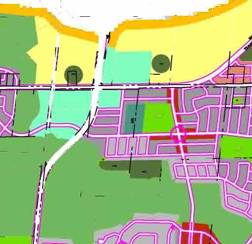
5 BURNHAMTHORPE ROAD EAST DUNDAS STREET EAST HIGHWAY 407 BURNHAMTHORPE ROAD EAST SITE DUNDAS STREET EAST SITE LOCATION NOT TO SCALE FIGURE 1
6 2 Proposed Development 2.1 Land Use Figure 2 shows the preliminary draft plan of subdivision provided by Bousfields Inc., dated December The subject lands are currently primarily agricultural and occupied by two small businesses. The surrounding lands are also primarily agricultural farmland to the north, east and west. The land to the south has been recently built-out with a mix of residential and commercial uses. The proposal is to develop approximately 2,000 townhouse/apartment units and a ha commercial block. The Dundas Trafalgar Inc. lands are designated within the Town of Oakville s Official Plan (February 2008) as an urban residential area and are proposed to be developed and marketed as part of the Trafalgar Urban Core Area. 2.2 Road System The internal road system currently shows a modified layout from that contained in the North Oakville East Secondary Plan resulting in a discontinuous north-south avenue/transit corridor through the development. A proposed realignment within Phase 2 has converted Street A into two roads north (Street D ) and south (Street A ) of Street C. Street C intersects Street D and Street A approximately 90 metres and 315 metres east of Trafalgar respectively. The subdivision has one connection to Dundas Street through the subdivision to the south, identified as Street A. Street A is a north-south Avenue/Transit Corridor, opposite Postridge Drive, that extends from Dundas Street to Street C. The subdivision has two connections to Trafalgar Road through the subdivision to the west, identified as Street B and Street C. Streets B and C are both east-west roads that extend from Trafalgar Road to the subdivision s east boundary, they are classified as an Avenue/Transit Corridor and a Connector/Transit Corridor respectively. In the future, both transit corridors will extend through the entire North Oakville Secondary Plan. The subdivision has one connection through the subdivision to the north, identified as Street D. Street D is a north-south Avenue/Transit Corridor that extends from Street C to the subdivision s north boundary. In the future, this transit corridor will extend through future development to the north and intersect with Burnhamthorpe Road and the New North Oakville Transportation Corridor. Access to the Dundas Street and Trafalgar Road Urban Core blocks will be provided by internal local roads. GHD Dundas Trafalgar Inc. Transit Facilities Plan December

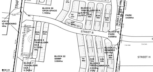
7 NOT TO SCALE PRELIMINARY DRAFT PLAN FIGURE 2
8 3 Transit Streets 3.1 North Oakville East Transit Plan The North Oakville East Transportation Plan has identified the transit routes that are intended to serve the new development north of Dundas Street. Within the Dundas Trafalgar Inc. lands the transit routes include the Postridge Drive extension (Street A ) and Street D in the north-south direction and Streets B and C in the east-west direction. Street A intersects Street B and Street C approximately 315 metres and 620 metres north of Dundas Street respectively. Street C intersects Street D approximately 90 metres east of Trafalgar Road. The North Oakville East Transportation Plan is appended. Streets A and D are classified as Avenue / Transit Corridors and proposed to provide community (local) service. The right-of-way width is 22 metres with a pavement width of 12.5 metres. This leaves 4.75 metres for boulevard on each side. Transit stop facilities will be located in the boulevards. Street C is classified as a Connector / Transit Corridor and is also proposed to provide community (local) service. The right-of-way width is 19 metres with a pavement width of 9.5 metres. This leaves 4.75 metres for boulevard on each side. Transit stop facilities will be located in the boulevards. Local services provide the highest degree of local access at the neighbourhood level. Some routes will be very similar to many of the existing local routes, operating at similar levels of service. These routes provide direct access to lower demand and existing areas, and operate on the network of arterial, avenue and connector roads. Transit riders will use these routes to access local destinations, such as schools or shopping, and as connections to the corridor routes for longer trips. Street B is classified as an Avenue / Transit Corridor and proposed to provide secondary transit corridor service. The right-of-way width is 22 metres with a pavement width of 12.5 metres. This leaves 4.75 metres for boulevard on each side. Transit stop facilities will be located in the boulevards. Secondary transit corridors provide high level of service, operate on the grid network of streets and provide cross-boundary connections. Trafalgar Road and Dundas Street are classified as Major Arterial / Transit Corridors and proposed to provide bus-way corridor service. The mid-block right-of-way width is 50 metres with a pavement width of 28.4 metres; two travel lanes, one bus only lane and a parking lane in each direction. The boulevard width on each side varies. Transit stop facilities will be located in the boulevards. All units in the subdivision are located less than 150 metres from one of the Transit Corridors which define the planned transit service routes. Samples of the North Oakville roadway cross-sections are appended. 3.2 Existing Transit Routes Oakville Transit Oakville Transit operates one transit route in close proximity to the site with a bus stop located 45 metres north of English Rose Lane on Postridge Drive. Route #20 (Northridge) provides north-south through Oakville s Trafalgar neighbourhood with 30-minute frequency during the weekday peak hours, and 60-minute frequency during the weekend peak hours. The route provides service to/from the Oakville GO Station to the Uptown Core Bus Terminal. GHD Dundas Trafalgar Inc. Transit Facilities Plan December
9 GO Transit GO Transit operates two routes along Trafalgar Road with a stop at the Dundas Street intersection, within 400 metres of the planned Street A intersection at Dundas Street. Route #20 (Milton/Oakville) provides north-south service along Trafalgar Road with one-way 60-minute frequency during the weekday a.m. peak hours from the Milton GO Station to the Oakville GO Station. During the weekday p.m. peak hours, one-way 60-minute frequency is provided from the Oakville GO Station to the Milton GO Station. There is no scheduled weekend bus service for this route. Route #46 (407 West) provides east-west via Trafalgar Road with 30-minute frequency during the weekday peak hours. The route provides service to/from the Oakville GO Station to York University. There is no scheduled weekend bus service for this route. 3.3 Dundas Street Bus Rapid Transit Halton Region with the City of Burlington and the Town of Oakville is carrying out a study to consider Bus Rapid Transit (BRT) within the Burlington and Oakville along Dundas Street and Trafalgar Road. The study provides an opportunity to develop improvements along both major arterials and other transit supportive corridors so that people living or working in Halton Region have a better alternative to automotive travel. The proposed infrastructure improvements will provide exclusive transit lanes on Dundas Street from Brant Street to Trafalgar Road, and on Trafalgar Road from the Oakville GO Station to the Oakville Highway 407 carpool lot. Curb BRT is preferred over Median BRT as it would provide slightly better BRT travel time and better integration with local transit services. The Trafalgar BRT Corridor study identifies potential far-side curb BRT stations at Street B on each side of Trafalgar Road. The Dundas BRT Corridor study identifies the closest potential BRT station at the Uptown Core Bus Terminal. GHD Dundas Trafalgar Inc. Transit Facilities Plan December
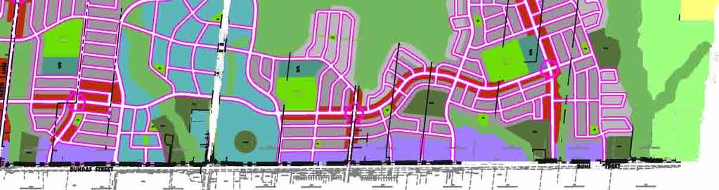
10 4 Transit stops Bus stop type Based on the warrants for bus stop levels of amenities such as; boarding volumes, transfer locations, land use activity type, type of road and wait time. Stop types A-Sheltered Info, C-Comfort and D-Basic transit stops are warranted for this area. A Type D-Basic bus stop should provide the following standard amenities: Sign and post Route designation Route schedules Route map(s) Shelter pads A Type C-Comfort bus stop should provide the same as a Type D-Basic plus a bench. A Type A-Sheltered Info bus stop should provide the same as a Type C-Comfort plus a shelter, lighting and power pedestal. The physical space requirement for Types D, C and A are 3.25, 4.00 and 4.75 metres, respectively, from the front of curb, including the sidewalk, which can be accommodated within the 4.75 metre boulevard that is available on the roads. No additional property is required to provide the described bus stops. Recommended bus stop type exhibits are appended. Streets A & D The street distance between Dundas Street and the north limit of the subdivision is approximately 1200 metres. This transit corridor would provide community service with connections to primary and secondary transit corridors with minute service frequency. North-south transit stops along Street A would be located at Dundas Street, Street B, Street C and mid-block approximately 150 metres north of Dundas Street. North-south transit stops along Street D would be located at Street C and approximately 80 metres south of the subdivision s north property limit at a local road T -intersection. Street C The street distance between Trafalgar Road and the east limit of the subdivision is approximately 390 metres. This transit corridor would provide community service with connections to primary and secondary transit corridors with minute service frequency. East-west transit stops along Street C would be located at Trafalgar Road, Street C and Street D. GHD Dundas Trafalgar Inc. Transit Facilities Plan December
11 Street B The street distance between Trafalgar Road and the east limit of the subdivision is approximately 390 metres. This transit corridor would provide secondary transit corridor service with connection to primary transit corridors and community (local) service with minute service frequency. East-west transit stops along Street C would be located at Trafalgar Road, Street A and approximately 170 metres east of Trafalgar Road at a local road T -intersection. Figure 3 shows the Functional Servicing Plan - Transit Stop Locations when full transit service is provided along the transit corridor roads. Spacing of transit stops ranges from 110 metres to 250 metres. GHD Dundas Trafalgar Inc. Transit Facilities Plan December


12 Ensure Connection Stop D Stop D Mid-Block Ensure Connection Stop C Stop D Stop D Far Side Stop D Stop D Stop D Ensure Connection Ensure Connection Stop A Stop D Mid-Block Stop D Stop C Stop C Stop C Stop C Ensure Connection Stop D Mid-Block Stop D Mid-Block Stop C Ensure Connection TRANSIT STOP COMMUNITY SERVICE SECONDARY TRANSIT CORRIDOR SERVICE BUSWAY CORRIDOR GO TRANSIT SERVICE FUNCTIONAL SERVICING PLAN TRANSIT STOP LOCATIONS FIGURE 3
13 5 Conclusions The transit facilities plan has evaluated conditions for the Dundas Trafalgar Inc. lands. The long term transit plan utilizes two Avenue/Transit Corridors in the north-south and east-west directions and a Connector/Transit Corridor in the east-west direction. These roads will form part of the continuous routes between Neyagawa Boulevard and White Oaks Golf Club (east-west), and between Dundas Street and the New North Oakville Transportation Corridor (north-south). The Dundas Trafalgar Inc. development is located adjacent to Dundas Street to the south, Trafalgar Road to the west and the Shield Bay subdivision to the east. This is consistent with the phasing objective of avoiding creation of lengthy transit routes with limited market. The number of residential units is 1,990, made up of a variety of dwelling types. All units are located less than 400 metres from one of the Transit Corridors which define the planned transit service routes. The proposed bus stops will be implemented at the maximum spacing of 250 metres along the transit routes. Based on the warrants for bus stop levels of amenities, Type A-Sheltered Info. Type C-Comfort and Type D-Basic stops are warranted for the area. Spacing of transit stops in ranges from 110 metres to 250 metres. Postridge Drive extension (Street A ) and Street B will be constructed prior to any occupancy in the subdivision. This will allow introductory transit service to be started whenever deemed appropriate. The actual route of initial transit service will be governed by the overall system services in operation at the time and practical integration of the new route. GHD Dundas Trafalgar Inc. Transit Facilities Plan December
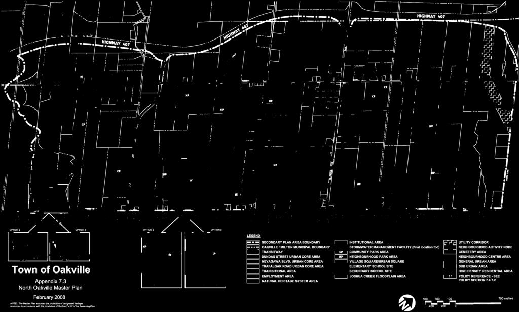
14 Appendix A North Oakville Plans

15 Exhibit 5A ~ North Oakville East Transportation Plan Town of Oakville Page 9

16
17 Appendix B Cross Sections
18
19
20 Appendix C Transit Stops
21 Exhibit 15 ~ Stop A, Sheltered Info Stop Page Town of Oakville
22 Exhibit 17 ~ Stop C, Comfort Page Town of Oakville
23 Exhibit 18 ~ Stop D, Basic Town of Oakville Page 25
24 GHD 6705 Millcreek Drive Unit 1 Mississauga Ontario L5N 5M4 Canada T: F: E: michael.dowdall@ ghd.com GHD 2012 This document is and shall remain the property of GHD. The document may only be used for the purpose for which it was commissioned and in accordance with the Terms of Engagement for the commission. Unauthorised use of this document in any form whatsoeverr is prohibited. \\mississauga2\sernastranstech\projects\2012\12237 MINTO TRAFALGAR DEVELOPMENTS\Reports\12237 Dundas Trafalgar Inc. Transit Facilities Plan Dec docx Document Status Rev No. 0 Author Michael Dowdall Reviewer Name William Maria Signature Approved for Issue Name Signature William Maria Date Dec

25
Prepared For: Shieldbay Developments Inc. c/o Matson, McConnell Ltd. 2430A Bloor Street West Toronto, Ontario M6S 1P9.
 Prepared For: Shieldbay Developments Inc. c/o Matson, McConnell Ltd. 2430A Bloor Street West Toronto, Ontario M6S 1P9 Prepared By: URS Canada Inc. 4 th Floor, 30 Leek Crescent Richmond Hill, Ontario L4B
Sixth Line Development - Transit Facilities Plan
 Memorandum Date: November 13, 2012 To: From: c.c. Subject: Rob Freeman (Freeman Planning) Kevin Phillips Sixth Line Development - Transit Facilities Plan 33016631 This memo was prepared to review the transit
VIVA RETIREMENT COMMUNITIES OAKVILLE TRAFFIC IMPACT STUDY
 VIVA RETIREMENT COMMUNITIES OAKVILLE TRAFFIC IMPACT STUDY VIVA RETIREMENT COMMUNITIES OAKVILLE TRAFFIC IMPACT STUDY DECEMBER 2012 READ, VOORHEES & ASSOCIATES TORONTO, ONTARIO Read, Voorhees & Associates
4. ALTERNATIVE DESIGN
 Chapter 4 Alternative Design 4. ALTERNATIVE DESIGN As noted in Chapters 1 and 2, Metrolinx Regional Transportation Plan (2008), The Big Move, a higher-order transit facility along Dundas Street between
North Oakville. Terms of Reference for Transportation Impact Studies and Transportation Functional Design Studies
 North Oakville Terms of Reference for Transportation Impact Studies and Transportation Functional Design Studies North Oakville Terms of Reference for Transportation Impact Studies and Transportation
Chapter 3 BUS IMPROVEMENT CONCEPTS
 Chapter 3 BUS IMPROVEMENT CONCEPTS The purpose of this chapter is to describe potential bus improvement strategies and potential impacts or implications associated with BRT implementation within the existing
APPENDIX 2 LAKESHORE ROAD TRANSPORTATION REVIEW STUDY EXECUTIVE SUMMARY
 APPENDIX 2 LAKESHORE ROAD TRANSPORTATION REVIEW STUDY EXECUTIVE SUMMARY Appendix 2 City of Mississauga Lakeshore Road FINAL REPORT Transportation Review Study December 2010 EXECUTIVE SUMMARY Study Purpose
APPENDIX 5. February 2013
 APPENDIX 5 APPENDIX 5 February 2013 APPENDIX 5-A Paper #5a Transit Service and Infrastructure Paper #5a TRANSIT SERVICE AND INFRASTRUCTURE This paper outlines public transit service within the Town of
Town of Oakville Growth Areas Transportation Report
 Growth Areas Transportation Report Oakville itrans Consulting Inc. 100 York Blvd., Suite 300 Richmond Hill, ON L4B 1J8 Tel: (905) 882-4100 Fax: (905) 882-1557 www.itransconsulting.com Growth Areas Transportation
Dundas Street (Regional Road 5) Corridor Improvements Class EA. Welcome to Public Information Centre #3. Thursday, September 13, 2012
 Corridor Improvements Class EA. Welcome to Public Information Centre #3. Thursday, September 13, 2012") Dundas Street (Regional Road 5) Corridor Improvements Class EA Welcome to Public Information Centre #3 Thursday, September 13, 2012 Members of the Project Team are available to discuss the information
Dundas Street (Regional Road 5) Corridor Improvements Class EA Welcome to Public Information Centre #3 Thursday, September 13, 2012 Members of the Project Team are available to discuss the information
Dundas Street (Regional Road 5) Corridor Improvements Class EA Neyagawa Boulevard to Oak Park Boulevard. Welcome Public Information Centre
 Corridor Improvements Class EA Neyagawa Boulevard to Oak Park Boulevard. Welcome Public Information Centre") Dundas Street (Regional Road 5) Corridor Improvements Class EA Neyagawa Boulevard to Oak Park Boulevard Welcome Public Information Centre Wednesday, May 15, 2013 Members of the Project Team are available
Dundas Street (Regional Road 5) Corridor Improvements Class EA Neyagawa Boulevard to Oak Park Boulevard Welcome Public Information Centre Wednesday, May 15, 2013 Members of the Project Team are available
EUCLID AVENUE PARKING STUDY CITY OF SYRACUSE, ONONDAGA COUNTY, NEW YORK
 EUCLID AVENUE PARKING STUDY CITY OF SYRACUSE, ONONDAGA COUNTY, NEW YORK CITY OF SYRACUSE DEPARTMENT OF PUBLIC WORKS 1200 CANAL STREET EXTENSION SYRACUSE, NEW YORK 13210 DRAFT REPORT DATE: November 13,
HENDERSON DEVELOPMENT 213, 217, 221, 221 ½, 223 HENDERSON AVENUE and 65 TEMPLETON STREET OTTAWA, ONTARIO TRANSPORTATION OVERVIEW.
 HENDERSON DEVELOPMENT 213, 217, 221, 221 ½, 223 HENDERSON AVENUE and 65 TEMPLETON STREET OTTAWA, ONTARIO TRANSPORTATION OVERVIEW Prepared for: 2294170 Ontario Inc. February 2, 2017 117-652 Report_1.doc
Decision on North Waterloo Routing
 Next Steps Decision on North Waterloo Routing Two route variations remain in north Waterloo. The final preferred route will include only one of the two variations. Please consider these two variations
Southwest Bus Rapid Transit (SW BRT) Functional Planning Study - Executive Summary January 19 LPT ATTACHMENT 2.
 Functional Planning Study - Executive Summary January 19 LPT ATTACHMENT 2.") Southwest Bus Rapid Transit (SW BRT) Functional Planning Study - Executive Summary 2011 January 19 1 of 19 Introduction This executive summary presents the results of the Southwest Bus Rapid Transit (SW
Southwest Bus Rapid Transit (SW BRT) Functional Planning Study - Executive Summary 2011 January 19 1 of 19 Introduction This executive summary presents the results of the Southwest Bus Rapid Transit (SW
OTTAWA TRAIN YARDS PHASE 3 DEVELOPMENT CITY OF OTTAWA TRANSPORTATION IMPACT STUDY. Prepared for:
 OTTAWA TRAIN YARDS PHASE 3 DEVELOPMENT CITY OF OTTAWA TRANSPORTATION IMPACT STUDY Prepared for: The Ottawa Train Yards Inc. 223 Colonnade Road South, Suite 212 Nepean, Ontario K2E 7K3 January 17, 2012
5 Transit & Traffic. Overview
 5 Transit & Traffic Overview Montgomery Place s roadways and overall traffic circulation are unique in the city due to the narrow streets and avenues with boulevards; however, no sidewalks or curbs in
Classification Criteria
 SCHEDULE D TO RECOMMENDED OFFICIAL PLAN AMENDMENT NO. 40 SCHEDULE C-4 Road Criteria Criteria Traffic Service Objective Land Service/Access Typical Daily Traffic Volume Flow characteristics Travel Speed
2136 And 2148 Trafalgar Road Townhouse Development Traffic Brief. Paradigm Transportation Solutions Limited
 2136 And 2148 Trafalgar Road Townhouse Development Traffic Brief Paradigm Transportation Solutions Limited March 217 March 217 Project: 1627 Diana Vlasic, M.C.I.P., R.P.P Metropolitan Consulting 445 Paletta
INTRODUCTION THOROUGHFARE SYSTEM CLASSIFICATIONS
 INTRODUCTION The thoroughfare plan will assist public officials in the development of a specialized system for efficient and safe movement of vehicular traffic while minimizing potential conflicts with
Welcome. If you have any questions or comments on the project, please contact:
 Welcome This drop-in public open house is intended to provide information about the Bay Street bike lanes project. This project proposes a dedicated cycling facility along Bay Street between Aberdeen Avenue
West Dimond Blvd Upgrade Jodhpur Street to Sand Lake Road
 West Dimond Blvd Jodhpur St to Sand Lake CSS Transportation Project Summary Municipality of Anchorage Project # 05 005 Project Manager: John Smith, P.E. (MOA PM&E) Project Administrator: Julie Makela,
9 Leeming Drive Redevelopment Ottawa, ON Transportation Brief. Prepared By: Stantec Consulting Ltd.
 9 Leeming Drive Redevelopment Ottawa, ON Transportation Brief Prepared By: Stantec Consulting Ltd. TIA GUIDELINES CHECKLIST Report Context Municipal Address Comment: Section 1.1 Location relative to major
OFFICE/RETAIL DEVELOPMENT 1625 BANK STREET OTTAWA, ONTARIO TRANSPORTATION BRIEF. Prepared for: Canada Inc.
 OFFICE/RETAIL DEVELOPMENT 1625 BANK STREET OTTAWA, ONTARIO TRANSPORTATION BRIEF Prepared for: 9402209 Canada Inc. December 15, 2015 115-625 Report_2.doc D. J. Halpenny & Associates Ltd. Consulting Transportation
5858 N COLLEGE, LLC N College Avenue Traffic Impact Study
 5858 N COLLEGE, LLC nue Traffic Impact Study August 22, 2016 Contents Traffic Impact Study Page Preparer Qualifications... 1 Introduction... 2 Existing Roadway Conditions... 5 Existing Traffic Conditions...
CPC Parking Lot Riverside Drive. Transportation Rationale
 CPC Parking Lot Transportation Rationale Prepared By: NOVATECH Suite 200, 240 Michael Cowpland Drive Ottawa, Ontario K2M 1P6 September 2015 Novatech File: 114093 Ref: R-2015-153 Table of Contents 1.0 INTRODUCTION...
CITY OF SASKATOON COUNCIL POLICY
 ORIGIN/AUTHORITY Clause 1, Report No. 1-1980 and Clause 4, Report No. 22-1990 of the Works and Utilities Committee; Clause 6, Report No. 17-2004 of the Planning and Operations Committee; and Clause D5,
BUS RAPID TRANSIT. A Canadian Perspective. McCormick Rankin International. John Bonsall P.Eng
 BUS RAPID TRANSIT A Canadian Perspective Why choose BRT? Because it is a practical and cost effective rapid transit solution for the most common types of land use in urban Canada Operating experience shows
5 CIRCULATION AND STREET DESIGN
 5 CIRCULATION AND STREET DESIGN This chapter describes circulation and streetscape improvements proposed for the Northwest Chico Specific Plan Area. It includes detailed design specifications for existing
MEDICAL/OFFICE BUILDING 1637 BANK STREET OTTAWA, ONTARIO TRANSPORTATION OVERVIEW. Prepared for:
 MEDICAL/OFFICE BUILDING 1637 BANK STREET OTTAWA, ONTARIO TRANSPORTATION OVERVIEW Prepared for: 2434984 Ontario Inc. 13-5510 Canotek Road Ottawa, Ontario K1J 9J5 June 4, 2015 115-613 Report_2.doc D. J.
STONY PLAIN ROAD STREETSCAPE
 Jasper Place Revitalization Strategy: Vision The people involved in the Jasper Place Revitalization Strategy envision: Goal 1: Feeling safe in our community Create a community where feeling safe is common--where
Public Works and Infrastructure Committee. General Manager, Transportation Services
 STAFF REPORT ACTION REQUIRED Extending the Bay Street Bicycle Lanes Date: May 16, 2013 To: From: Public Works and Infrastructure Committee General Manager, Transportation Services Wards: Toronto Centre
7 June 2018 OUR REF:
 7 June 2018 OUR REF: 476729-01000 Mirtillo Estates Inc. 1681 Langstaff Road, Unit 1 Vaughan, Ontario, L4K 5T3 Attention: Joran Weiner Vice-President Dear Mr. Weiner: Re: Mirtillo Estates Sales Office Transportation
In station areas, new pedestrian links can increase network connectivity and provide direct access to stations.
 The Last Mile Planning for Pedestrians Planning around stations will put pedestrians first. Making walking to stations safe and easy is important; walking will be a part of every rapid transit Accessible
NEWMARKET CENTRE Mobility Hub Profile
 Mobility Hub Profile Dundas Newmarket West-Bloor Centre Anchor Hub Gateway Hub N MOBILITY HUBS: Places of connectivity between regional and rapid transit services, where different modes of transportation
Downtown BRT Corridor Alternatives Review: 1 st, 2 nd, 3 rd and 4 th Avenue. Bus Rapid and Conventional Transit Planning and Design Services
 Downtown BRT Corridor Alternatives Review: 1 st, 2 nd, 3 rd and 4 th Avenue Bus Rapid and Conventional Transit Planning and Design Services City of Saskatoon February 2018 Project Team HDR Corporation
Roadways. Roadways III.
 Introduction 97 Roadway Design Principles 98 Safe Speeds 99 Optimizing of Street Space 00 Minimum Lane Widths in the City of Boston 02 Design Features that Reduce Operating Speeds 05 Travel Lanes Transit
AMEC Earth and Environmental. Bovaird Drive Environmental Assessment. Traffic Study Final Report. August Excellence in Transportation Planning
 AMEC Earth and Environmental Bovaird Drive Environmental Assessment Traffic Study Final Report August Excellence in Transportation Planning AMEC Earth and Environmental Bovaird Drive Class EA Traffic
M-58 HIGHWAY ACCESS MANAGEMENT STUDY Mullen Road to Bel-Ray Boulevard. Prepared for CITY OF BELTON. May 2016
 M-58 HIGHWAY ACCESS MANAGEMENT STUDY Prepared for CITY OF BELTON By May 2016 Introduction Missouri State Highway 58 (M-58 Highway) is a major commercial corridor in the City of Belton. As development has
NEW YORK CENTRAL PARK SUBDIVISION BLAIS STREET/ST-PIERRE STREET EMBRUN, ONTARIO TRAFFIC IMPACT STUDY. Prepared for:
 NEW YORK CENTRAL PARK SUBDIVISION BLAIS STREET/ST-PIERRE STREET EMBRUN, ONTARIO TRAFFIC IMPACT STUDY Prepared for: Solidex Holdings Limited & Investissement Maurice Lemieux Investments Attn: Mr. Anthony
2.0 LANE WIDTHS GUIDELINE
 2.0 LANE WIDTHS GUIDELINE Road Engineering Design Guidelines Version 2.0.1 May 2018 City of Toronto, Transportation Services City of Toronto Page 0 Background In early 2014, Transportation Services initiated
Corporation of the Town of Oakville. December 16, 2013
 Corporation of the Town of Oakville Transportation Impact Analysis and Parking Study for Proposed Secondary School, Oakville Draft Final Report Submitted by: HDR Corporation 100 York Boulevard, Suite 300
DON MILLS-EGLINTON Mobility Hub Profile
 Mobility Hub Profile Dundas Don Mills-Eglinton West-Bloor Anchor Hub Gateway Hub N MOBILITY HUBS: Places of connectivity between regional and rapid transit services, where different modes of transportation
Fieldgate. Traffic Impact Study Proposed Retail Commercial and Residential Development Thompson Road and Louis St. Laurent Avenue Town of Milton
 Fieldgate Traffic Impact Study Proposed Retail Commercial and Residential Development Thompson Road and Louis St. Laurent Avenue Town of Milton September 214 September 23 214 Ms Debbie Pacchiarotti Our
Cycling Network Plan Implementation in Thorncliffe Park and Flemingdon Park
 PW28.13 REPORT FOR ACTION Cycling Network Plan Implementation in Thorncliffe Park and Flemingdon Park Date: March 26, 2018 To: Public Works and Infrastructure Committee From: General Manager, Transportation
TOWN OF CHAPEL HILL POLICY AND PROCEDURES FOR TRAFFIC CALMING MEASURES
 TOWN OF CHAPEL HILL POLICY AND PROCEDURES FOR TRAFFIC CALMING MEASURES (Adopted by the Town Council on June 30, 2004) (Revised December 6, 2010) (Revised February 8, 2016) POLICY AND PROCEDURES FOR TRAFFIC
Multimodal Through Corridors and Placemaking Corridors
 68 Multimodal Through Corridors and Placemaking Corridors Corridors have different functions in a region. Some corridors are used to get smoothly and rapidly through a region or to get quickly to major
Circulation in Elk Grove includes: Motor vehicles, including cars and trucks
 Circulation, as it is used in this General Plan, refers to the many ways people and goods move from place to place in Elk Grove and the region. Circulation in Elk Grove includes: Motor vehicles, including
Noise Assessment Technical Memorandum. City of Mississauga Rathburn Road Transit Priority Measures Transit Project Assessment Process
 City of Mississauga Rathburn Road Noise Assessment Technical Memorandum McCORMICK RANKIN CORPORATION 2655 North Sheridan Way Mississauga, Ontario, L5K 2P8 Tel: (905)823-8500 Fax: (905) 823-8503 E-mail:
PALERMO TRANSIT TERMINAL LOCATION STUDY
 FINAL REPORT NOVEMBER 2010 DOCUMENT CONTROL Client: Project Name: Report Title: Palermo Transit Terminal location Study Palermo Transit Terminal Location Study IBI Reference: 26886 Version: Digital Master:
Cyclists and Bikeways: What s your match? A guide to bikeway options for a variety of cyclists
 Cyclists and Bikeways: What s your match? guide to bikeway options for a variety of cyclists The workshop and this resource were made possible by funding from the Province of Ontario via the Ministry of
Goodlettsville Bicycle and Pedestrian Plan Executive Summary
 Goodlettsville Bicycle and Pedestrian Plan July 2010 In Cooperation with the Nashville Area Metropolitan Planning Executive Organization Summary Introduction Progressive and forward thinking communities
SECTION 1 - TRAFFIC PLANNING
 SECTION 1 - TRAFFIC PLANNING 1.1 TRAFFIC OPERATIONS 1.1.1 Roadway Functional Classification The Multnomah County Comprehensive Framework Plan s Policy 34: Trafficways and the Functional Classification
Roadway Classification Review
 District of North Vancouver 355 West Queens Road North Vancouver British Columbia V7N 4N5 Roadway Classification Review District of North Vancouver January 2013 District of North Vancouver Roadway Classification
DUNDAS WEST-BLOOR Mobility Hub Profile
 Mobility Hub Profile Dundas West-Bloor Anchor Hub Gateway Hub N MOBILITY HUBS: Places of connectivity between regional and rapid transit services, where different modes of transportation come together
ORLEANS GARDENS SHOPPING CENTRE 1615 ORLEANS BOULEVARD CITY OF OTTAWA, ONTARIO TRANSPORTATION IMPACT STUDY. Prepared for:
 ORLEANS GARDENS SHOPPING CENTRE 1615 ORLEANS BOULEVARD CITY OF OTTAWA, ONTARIO TRANSPORTATION IMPACT STUDY Prepared for: Orleans Gardens Shopping Centre Inc. 2851 John Street, Suite 1 Markham, ON K3R 5R7
Executive Summary BEYOND THE B-LINE: RAPID TRANSIT LINE PHASE II - COMMERCIAL DRIVE WEST. Final Draft December 13, Appendix B BROADWAY/LOUGHEED
 BEYOND THE B-LINE: BROADWAY/LOUGHEED RAPID TRANSIT LINE PHASE II - COMMERCIAL DRIVE WEST Appendix B Executive Summary Final Draft December 13, 1999 UMA Lloyd Lindley Davidson Yuen Simpson Architects BROADWAY/LOUGHEED
4 DISRUPTION MANAGEMENT PLAN HIGHWAY 7 RAPIDWAY CONSTRUCTION BETWEEN BAYVIEW AVENUE AND WARDEN AVENUE TOWNS OF MARKHAM AND RICHMOND HILL
 4 DISRUPTION MANAGEMENT PLAN HIGHWAY 7 RAPIDWAY CONSTRUCTION BETWEEN BAYVIEW AVENUE AND WARDEN AVENUE TOWNS OF MARKHAM AND RICHMOND HILL The Transportation Services Committee recommends the adoption of
T A B L E OF C O N T E N T S
 T A B L E OF C O N T E N T S PART III SUBDIVISION REGULATIONS OF THE DEPARTMENT OF PUBLIC WORKS, C & C D PAGE PAGE Responsibility for Development of Streets......... 29 Right-of-Way Widths...... 37 Purpose...........
Welcome to the Open House
 Leslie Street Between 19 th Avenue and Stouffville Road Addendum to Class Environmental Assessment Study Welcome to the Open House Please sign in at the front desk. March 28, 2017 Richmond Green Sports
Traffic Control Signals - Cosburn Avenue and Cedarvale Avenue
 REPORT FOR ACTION Traffic Control Signals - Cosburn Avenue and Cedarvale Avenue Date: April 24, 2017 To: Toronto and East York Community Council From: Acting Director, Transportation Services, Toronto
MONTGOMERY COUNTY PLANNING DEPARTMENT THE MARYLAND-NATIONAL CAPITAL PARK AND PLANNING COMMISSION
 MONTGOMERY COUNTY PLANNING DEPARTMENT THE MARYLAND-NATIONAL CAPITAL PARK AND PLANNING COMMISSION MCPB Item No. 3 Date: 01-19-12 Worksession: Countywide Transit Corridors Functional Master Plan Larry Cole,
Harbord Street and Hoskin Avenue Bicycle Lane Upgrades
 STAFF REPORT ACTION REQUIRED and Bicycle Lane Upgrades Date: April 22, 2014 To: From: Wards: Reference Number: Public Works and Infrastructure Committee General Manager, Transportation Services 19 and
S T A T I O N A R E A P L A N
 The Circulation and Access Plan describes vehicle, pedestrian, and transit improvements recommended within the Concept Plan. In order to create and sustain a vibrant business district that provides pedestrian-friendly
Road Alterations - Wellington Street East, Church Street, and Front Street Intersection
 REPORT FOR ACTION Road Alterations - Wellington Street, Church Street, and Front Street Intersection Date: November 1, 2016 To: Toronto and York Community Council From: Director, Public Realm Section,
Centennial Neighbourhoods Transportation Management Plan Summary of Phase 1 Consultation. Overview of Issues
 1 Centennial Neighbourhoods Transportation Management Plan Summary of Phase 1 Consultation The Centennial Neighbourhoods Transportation Management Plan (CNTMP) is being undertaken to support the Secondary
Corridor Advisory Group and Task Force Meeting #10. July 27, 2011
 Corridor Advisory Group and Task Force Meeting #10 July 27, 2011 1 Agenda Recap CAG/TF #9 Public Meeting #2 Summary Single Mode Alternatives Evaluation Results Next Steps 2 3 CAG/TF #9 Recap CAG /TF #9
City of Tamarac, Florida Traffic Calming Policy
 City of Tamarac, Florida Traffic Calming Policy Temp. Reso. 12614 Exhibit 1 I. Introduction: The City of Tamarac recognizes that the conditions of residential streets can greatly affect neighborhood livability
Proposed Bridge Street East Bicycle Lanes Public Open House Thursday, April 27, 2017
 WELCOME Proposed Bridge Street East Bicycle Lanes Public Open House Thursday, April 27, 2017 Purpose of the Open House The purpose of this Open House is to gain public input on the bicycle lanes proposed
Main-McVay Transit Study: Phase 2 Options Definition and High Level Constraints Evaluation
 Main-McVay Transit Study: Phase 2 Options Definition and High Level Constraints Evaluation APRIL 2016 A collaborative study between: For Additional Information or to Comment If you would like additional
BLUE SEA VILLAGE MER BLEUE 2159 MER BLEUE ROAD OTTAWA, ONTARIO TRANSPORTATION IMPACT ASSESSMENT. Prepared for: Ontario Limited.
 BLUE SEA VILLAGE MER BLEUE 2159 MER BLEUE ROAD OTTAWA, ONTARIO TRANSPORTATION IMPACT ASSESSMENT Prepared for: 2534189 Ontario Limited April 6, 2018 117-668 TIA Report_2.doc D. J. Halpenny & Associates
Highway 111 Corridor Study
 Highway 111 Corridor Study June, 2009 LINCOLN CO. HWY 111 CORRIDOR STUDY Draft Study Tea, South Dakota Prepared for City of Tea Sioux Falls Metropolitan Planning Organization Prepared by HDR Engineering,
Donahue Drive Corridor Traffic Operational Evaluation
 Donahue Drive Corridor Traffic Operational Evaluation PREPARED FOR: THE CITY OF AUBURN PREPARED BY: JANUARY 2007 Donahue Drive Corridor Study--Auburn, Alabama TABLE OF CONTENTS Introduction... 1 Background
MASTER BICYCLE AND PEDESTRIAN PLAN
 VILLAGE OF NORTHBROOK MASTER BICYCLE AND PEDESTRIAN PLAN DRAFT PLAN OPEN HOUSE May 2, 2018 AGENDA 1. Community Engagement 2. Vision and Goals 3. General Structure of Plan 4. Recommendations Overview 5.
CITY OF VANCOUVER ADMINISTRATIVE REPORT
 CITY OF VANCOUVER ADMINISTRATIVE REPORT Report Date: May 31, 2007 Author: Paul Storer Phone No.: 604.873.7693 RTS No.: 06348 VanRIMS No.: 13-5000-20 Meeting Date: June 12, 2007 TO: FROM: SUBJECT: Standing
PEDESTRIAN ACTION PLAN
 ATTACHMENT 2 CITY OF SANTA MONICA PEDESTRIAN ACTION PLAN CITY OF SANTA MONICA PEDESTRIAN ACTION PLAN This page intentionally left blank EXECUTIVE SUMMARY CHAPTER 1 EXECUTIVE SUMMARY Setting the Stage
Frequently Asked Questions (FAQ)
") Frequently Asked s (FAQ) Study Process... 2 Rapid Transit Service and Operations... 5 Public Consultation... 8 Business Impacts... 8 Design and Property Impacts... 9 Construction Impacts...12 Traffic,
Frequently Asked s (FAQ) Study Process... 2 Rapid Transit Service and Operations... 5 Public Consultation... 8 Business Impacts... 8 Design and Property Impacts... 9 Construction Impacts...12 Traffic,
Access Management Guidelines February 2013 THE CITY OF
 Access Management Guidelines February 2013 THE CITY OF Table of Contents Introduction 2 Review and Approval Process 5 Technical Guidelines 9... 10... 12 3. Separation Distance: Non-Signalized All-Turns
Transportation Corridor Studies: Summary of Recommendations
 Transportation Corridor Studies: Summary of Recommendations Route 4 Corridor Study: Route 10 Corridor Study: Route 44 Corridor Study: Route 175 Corridor Study: Route 5/15 Corridor Study: Rentschler Field
DUNBOW ROAD FUNCTIONAL PLANNING
 DUNBOW ROAD FUNCTIONAL PLANNING Final Report August 3, 216 #31, 316 5th Avenue NE Calgary, AB T2A 6K4 Phone: 43.273.91 Fax: 43.273.344 wattconsultinggroup.com Dunbow Road Functional Planning Final Report
83 AVENUE PRE-CONSTRUCTION MEETING
 83 AVENUE PRE-CONSTRUCTION MEETING April 6, 2017 5-8PM Please visit displays for project information Talk to staff, ask questions, visit website at: www.edmonton.ca/bike83avenue Pre-Construction Meeting
Appendix B Transportation Report
 Project File Report Appendix B Transportation Report Town of Whitby HMM Project No. 327878 Final Report October 2014 Revision and Version Tracking CP Rail Crossing at New Coronation Road Class EA Study
CONNECTING PEOPLE TO PLACES
 CONNECTING PEOPLE TO PLACES 82 EAST BENCH MASTER PLAN 07 Introduction The East Bench transportation system is a collection of slow moving, treelined residential streets and major arteries that are the
Complete Street Analysis of a Road Diet: Orange Grove Boulevard, Pasadena, CA
 Complete Street Analysis of a Road Diet: Orange Grove Boulevard, Pasadena, CA Aaron Elias, Bill Cisco Abstract As part of evaluating the feasibility of a road diet on Orange Grove Boulevard in Pasadena,
Brian McHugh, Buckhead Community Improvement District. SUBJECT: Wieuca Road at Phipps Boulevard Intersection Improvements Project
 MEMO TO: FROM: Brian McHugh, Buckhead Community Improvement District Jagan Kaja, AICP, WSP Parsons Brinckerhoff SUBJECT: Wieuca Road at Phipps Boulevard Intersection Improvements Project DATE: October
This chapter describes the proposed circulation system and transportation alternatives associated with
 5.0 Circulation 5.1 OVERVIEW This chapter describes the proposed circulation system and transportation alternatives associated with West Landing, and summarize the information contained in the Existing
Station Plan: Penn & 43rd Avenue
 Station Plan: Penn & 43rd Avenue This station will serve the northern portion of the Penn Avenue corridor, including the commercial node at 44th Avenue. Ridership and roadway geometry support station siting
Tonight is for you. Learn everything you can. Share all your ideas.
 Strathcona Neighbourhood Renewal Draft Concept Design Tonight is for you. Learn everything you can. Share all your ideas. What is Neighbourhood Renewal? Creating a design with you for your neighbourhood.
INDUSTRIAL BUILDING 3009 HAWTHORNE ROAD CITY OF OTTAWA TRANSPORTATION OVERVIEW REVISED. Prepared for: Canada Inc.
 INDUSTRIAL BUILDING 3009 HAWTHORNE ROAD CITY OF OTTAWA TRANSPORTATION OVERVIEW REVISED Prepared for: 7849648 Canada Inc. Octiober 1, 2015 114-598 Overview_2.doc D. J. Halpenny & Associates Ltd. Consulting
Markham Sports, Entertainment and Cultural Centre Transportation Overview
 Markham Sports, Entertainment and Cultural Centre Transportation Overview ARENA LOCATION 2 3 TRANSPORTATION VISION IN MARKHAM On April 12, 2011, Markham Council adopted a long-term Transportation Vision
Long Island Rail Road Expansion Project Floral Park to Hicksville
 Long Island Rail Road Expansion Project Floral Park to Hicksville Final Environmental Impact Statement Appendix 1-D Complete Streets Policy Checklist April 2017 0902ML PIN: Project Location: 18A-4 Floral
TECHNICAL MEMORANDUM. Introduction
 TECHNICAL MEMORANDUM To: From: John M. Welsh Chris Furlong AHC, Inc. Andrew T. Smith, P.E. Edward Y. Papazian, P.E. Kimley-Horn and Associates, Inc. Date: July 6, 2017 Subject: 200 9 th reet South Redevelopment
Appendix G. Mavis Road / Sombrero Way Multi-Use Trail Design Alternatives
 Appendix G Mavis Road / Sombrero Way Multi-Use Trail Design Alternatives MEMO To: Dana Glofcheskie, City of Mississauga Date: October 17, 2016 From: Stefan Sirianni, E.I.T., MMM Group Job No.: 3215102
10.0 CURB EXTENSIONS GUIDELINE
 10.0 CURB EXTENSIONS GUIDELINE Road Engineering Design Guidelines Version 1.0 March 2017 City of Toronto, Transportation Services City of Toronto Page 0 Background In early 2014, Transportation Services
122 Avenue: 107 Street to Fort Road
 : 107 Street to Fort Road November 24, 2015 4:30 8:00 p.m. Meeting Purpose Summarize project work completed to date Share results of public input from Phase 1 Share the draft concept plan and proposed
WELCOME TO OPEN HOUSE # 1 June 14, 2017
 Langstaff Road Weston Road to Highway 7 Class Environmental Assessment Study WELCOME TO OPEN HOUSE # 1 June 14, 2017 Please sign in and join our mailing list Purpose of Open House #1 & Study Area York
3.0 PROJECT DESCRIPTION
 The following section of the Draft EIR contains a description of the proposed Elk Grove Boulevard/SR 99 Interchange Modification project, consistent with the requirements of CEQA Guidelines Section 15124.
EL CAMINO REAL BUS RAPID TRANSIT PROJECT
 EL CAMINO REAL BUS RAPID TRANSIT PROJECT Would upgrade the current 522 Rapid Bus to BRT status by making changes to El Camino Real and The Alameda that make transit FAST, FREQUENT AND RELIABLE and make
Town of Milton. Derry Green Corporate Business Park Secondary Plan. Transportation Strategy Report Final. December 2010
 Town of Milton Derry Green Corporate Business Park Secondary Plan Transportation Strategy Report Final December 2010 Excellence in Transportation Planning Town of Milton Derry Green Corporate Business
ALLEY 24 TRAFFIC STUDY
 ALLEY 24 TRAFFIC STUDY in City of Frostburg, Maryland January 2013 3566 Teays Valley Road Hurricane, WV Office: (304) 397-5508 www.denniscorporation.com Alley 24 Traffic Study January 2013 Frostburg, Maryland