ROAD SAFETY AUDIT. Route 1 at Route 123 Route 1 at Route 1A Route 1 at May Street Route 1A and Route 123. City of Attleboro, MA. September 15, 2015
|
|
|
- Barbara Dawson
- 6 years ago
- Views:
Transcription

1 ROAD SAFETY AUDIT Route 1 at Route 123 Route 1 at Route 1A Route 1 at May Street Route 1A and Route 123 City of Attleboro, MA September 15, 2015 Prepared For: MassDOT On Behalf Of: Prepared By: Fay, Spofford & Thorndike 15 Broad Street Suite 301 Boston, Massachusetts
2 Road Safety Audit Route 1, 1A, 123 and May Street Intersections in Attleboro, MA Prepared by FST Table of Contents Contents Background... 1 Project Data... 2 Project Location and Description... 3 Audit Observations and Potential Safety Enhancements... 8 Summary of Road Safety Audit List of Appendices Appendix A. Appendix B. Appendix C. Appendix D. RSA Meeting Agenda RSA Audit Team Contact List Detailed Crash Data Additional Information List of Figures Figure 1: Locus Map... 5 Figure 2: Project Area Northern Portion... 6 Figure 3: Project Area Southern Portion... 7 List of Tables Table 1: Participating Audit Team Members... 2 Table 2: Estimated Time Frame and Costs Breakdown Table 3: Potential Safety Enhancement Summary - Route 1 at Route Table 4: Potential Safety Enhancement Summary - Route 1 at Route 1A Table 5: Potential Safety Enhancement Summary - Route 1 at May Street Table 6: Potential Safety Enhancement Summary - Route 1A at Route
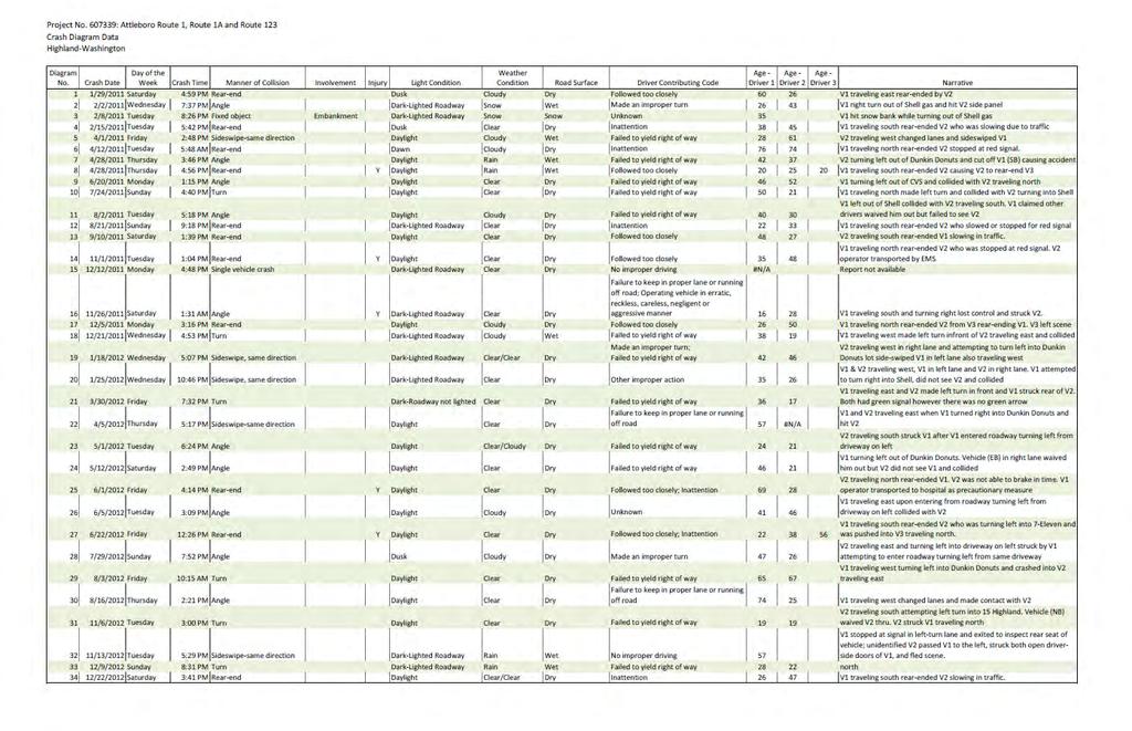
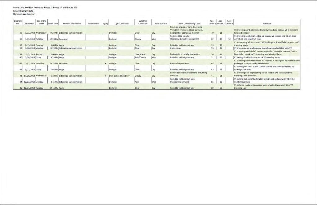
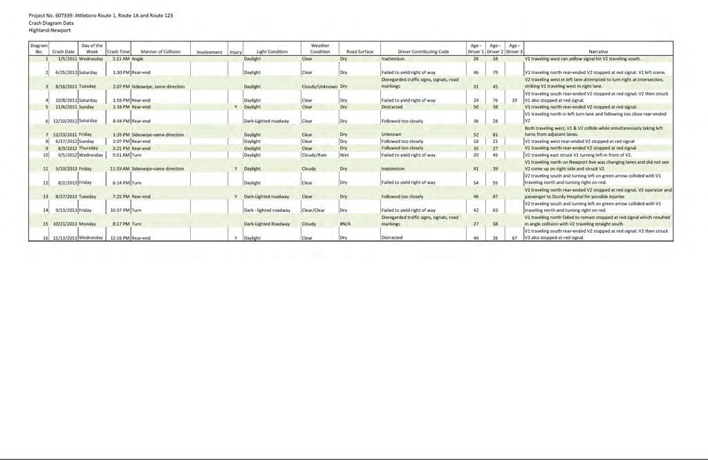
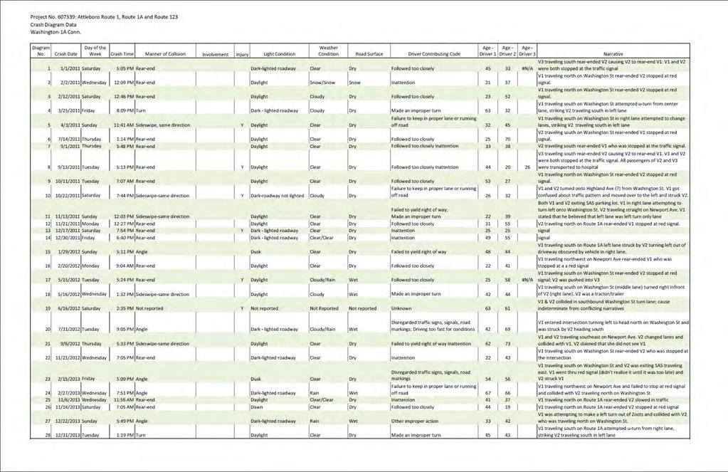
3 Road Safety Audit Route 1, 1A, 123 and May Street Intersections in Attleboro, MA Prepared by FST Background The Federal Highway Administration defines a Road Safety Audit (RSA) as the formal safety examination of an existing or future road or intersection by an independent, multidisciplinary team. The purpose of an RSA is to identify potential safety issues and possible opportunities for safety improvements considering all roadway users. Fay, Spofford & Thorndike (FST) has been contracted by the Massachusetts Department of Transportation (MassDOT) Highway Division s District 5, in cooperation with the City of Attleboro, to provide consulting services to evaluate potential transportation improvements at four closely-spaced intersections in Attleboro in the southern part of Attleboro between Exits 2 and 3 on I-95. As shown on Figure 1, these intersections include: Route 1 (Washington Street) at Route 123 (Highland Avenue), Route 1 (Washington Street) at Route 1A (Newport Avenue Connector), Route 1 (Washington Street) at May Street, and Route 1A (Newport Avenue Connector) at Route 123 (Newport Avenue) The area is urban and contains a number of commercial driveways leading to shopping centers, restaurants and other retail uses such as a grocery store, pharmacy, gas station, and a convenience store among others. Some of these uses have multiple driveways and curb cuts for access. Two of the four intersections are deemed a Highway Safety Improvement Program (HSIP) High Crash Locations by MassDOT. These HSIP intersections include: Route 1 (Washington Street) at Route 123 (Highland Avenue), and Route 1 (Washington Street) at May Street. In addition to being a high crash location, Route 1 at Route 123 is also on the MassDOT State Wide Top 200 Crash Location List for the years These intersections have been identified as being in need of transportation improvements and are currently undergoing the 25% Design Process. The work is scheduled to be funded under the State Transportation Improvements Plan (TIP) for As part of the assessment process, FST investigated the crash reports for the prior three years from January 2011 to December 2013 provided by the Attleboro Police Department, and developed crash diagrams to identify and depict the crash location frequencies, the crash types and the severity of each crash. Page 1
4 Road Safety Audit Route 1, 1A, 123 and May Street Intersections in Attleboro, MA Prepared by FST Project Data After the crash data was reviewed, FST conducted an on-site RSA with participating parties (see Table 1 for the members of the Audit Team) at the Attleboro South Fire Station on May 29 th, 2015 at 1476 West Street in Attleboro, MA. The Audit Team consisted of a multi-disciplined team of State engineers; law enforcement professionals, maintenance and emergency response professionals, as well as City representatives. The Audit Team was assembled and the RSA was conducted in conjunction with input from MassDOT s Safety Management Unit. A list of the Audit Team members is provided in Appendix B. The purpose of this meeting was to identity key issues and discusses potential short-term and longterm improvements and solutions. Prior to the Audit, FST provided the participants with crash diagrams and maps of the RSA study area. An existing conditions aerial photo (Figure 2 and 3) was also provided to depict specific project focus areas as it related to the discussion. Participants were encouraged to visit the intersections prior to the Audit and were urged to consider elements from MassDOT s Safety Review Prompt List (also included in the handout materials provided as Attachment E). Table 1: Participating Audit Team Members Audit Team Member Agency/Affiliation Ron Dubuc Attleboro Dept. of Public Works - Highway Division Walter Thibodeau Attleboro Municipal Council Dennis Perkins Attleboro Fire Dept. Kyle Heagney Attleboro Police Dept. (ADP) John Mastera MassDOT Highway Division Edward Feeney MassDOT Highway Division District 5 Nitza Otero MassDOT - MassRIDES Safe Routes to School Jacqueline Schmidt SRPEDD Patrick Dunford Vanasse Hangen Brustlin (VHB) Sarah Borenstein Fay, Spofford & Thorndike Heather Ostertog Fay, Spofford & Thorndike William Ullom MassDOT Highway Division Stephanie Davies City of Attleboro, Planning Gary Agrassian City of Attleboro, Planning Richard Oliveira MassDOT Highway Division District 5 Page 2
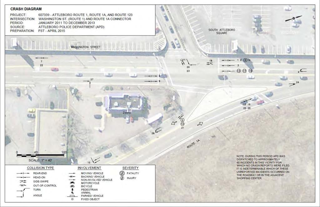
5 Road Safety Audit Route 1, 1A, 123 and May Street Intersections in Attleboro, MA Prepared by FST Project Location and Description The Audit Team gathered in the field to observe the four intersections. Surrounding Area These four intersections are a priority for the City of Attleboro and other neighboring communities for transportation improvements because of the land uses associated near the intersections. Route 1 in the RSA study area is an important shopping and retail corridor for Attleboro and the surrounding towns. The four intersections are also located at a short distance from three interchanges with I-95: at Route 123, Route 1A, and Route 1. The Route 1 interchange with I-295 is also at close proximity to the RSA study area. Furthermore, the MBTA South Attleboro commuter rail station is located on Route 1A, approximately1.6-miles south of the Route 1A at Route 123 intersections. The South Attleboro station, located on the Providence Line, has an average boarding of over 1,400 riders a day. The following sections provide a detailed description of the major roadways in the RSA study area. Route 1 (Washington Street), Attleboro, MA Route 1 (Washington Street) in Attleboro is a state-owned urban arterial which runs in a north-south direction (see Figure 2B). In the RSA study area, Route 1 has a four lane cross-section (two lanes in each direction) and is undivided. Route 1 is densely developed with commercial properties with numerous driveway curb-cuts. Retail properties in the RSA study area include the South Attleboro Shopping Center, BJ s Wholesale Club, Stop and Shop grocery store, CVS pharmacy, Dunkin Donuts, Sunoco Gas Station, Zoot s Dry Cleaning, and a 7-Eleven Convenience Store. North to Angeline Drive, there are sidewalks on both sides of Route 1 from Route 123. North of the Route 1 and Angeline Drive intersection, there are only sidewalks on the west side of Route 1. From the Route 1/Route 123 intersection, Route 1 carries traffic at a distance of 1.6 miles south to I-95 at Exit 1 towards Pawtucket, RI, and 2.1 miles north to I-295 Exit 16 towards the Emerald Square Mall in North Attleboro. Route 1A/ Newport Avenue Route 1A (Newport Avenue) is a state-owned urban arterial which runs in a north-south direction (see Figure 2A). Route 1A in the RSA study area has a four lane cross section (two lanes in each direction) and is undivided. Route 1A in the RSA study area has commercial uses and driveways, including a driveway to Seven-Eleven and to a tuxedo rental store. There are sidewalks located on both sides of Route 1A in the RSA study area. From the Route 1/ Route1A intersection, Route 1A carries traffic 1.4 miles south to Exit 2 onto I-95, as well as to the South Attleboro commuter rail station on the Providence line. Page 3
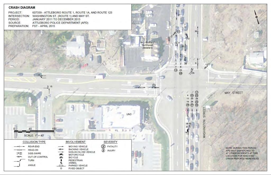
6 Road Safety Audit Route 1, 1A, 123 and May Street Intersections in Attleboro, MA Prepared by FST Route 123 (Highland Avenue) Route 123 is a four lane cross-section roadway between Route 1 to Route 1A. East of Route 1A, Route 123 narrows to two lanes (see Figure 2B). Four lanes of traffic are carried west through the Route 1A/Route 1 intersection but then the roadway tapers down to two lanes after 600 feet. The I-95/Route 123 Interchange is approximately 2.2 miles east of the Route 123/Route 1A intersection. Sidewalks exist on both sides of Route 123 between Route 1 and Route 1A. There are also sidewalks on both sides of Route 123 east of Route 1A, but exist only on the southern side of Route 123 west of Route 1. There is dense commercial development with related driveways and curb cuts located on Route 123. In the RSA study area; there are driveways for BJ s Wholesale Club, Sunoco gas station, Dunkin Donuts, CVS pharmacy and D Angelo s restaurant. There are also two small granite monuments located adjacent to Route 123. One is on the northeast corner of Route 1 and Route 123 and the other one is located on the southwest corner of Route 123 and Route 1A. May Street May Street is a two-lane residential street that widens to three lanes (two westbound and one eastbound lane) as it approaches Route 1 (see Figure 2B). The two westbound lanes consist of an exclusive right-turn lane and one through lane. The two lane eastbound approach of May Street to Route 1 widens to three lanes, consisting of an exclusive left-turn lane, a shared left and through lane and an exclusive right-turn lane. May Street provides a connection from Route 1 to Route 123 with only one intersection under signalized control within the 0.25-mile distance between these two highways. The other way to access Route 123 from Route 1 in this area is via three signalized intersections. Local drivers familiar with the area will use May Street to access Route 123 instead of Route 1A. Page 4

7 Road Safety Audit Route 1, 1A, 123 and May Street Intersections in Attleboro, MA Prepared by FST Figure 1: Locus Map Page 5

8 Road Safety Audit Route 1, 1A, 123 and May Street Intersections in Attleboro, MA Prepared by FST Figure 2: Project Area - Northern Section Page 6

9 Road Safety Audit Route 1, 1A, 123 and May Street Intersections in Attleboro, MA Prepared by FST Figure 3: Project Area - Southern Portion Page 7
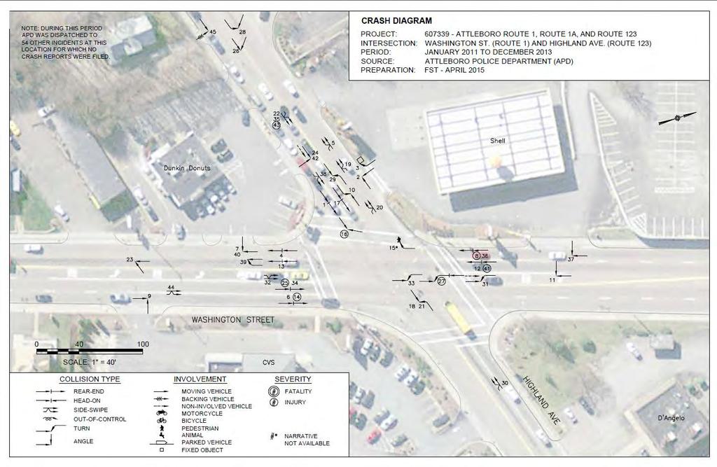
10 Road Safety Audit Route 1, 1A, 123 and May Street Intersections in Attleboro, MA Prepared by FST On the day of the Audit, a meeting was held at the Attleboro South Fire Station to discuss the audit process, review the distributed materials, and discuss the issues that the audit team members had observed in individual pre-audit visits to the site, or from past personal experiences and knowledge of the project area. Questions and concerns about the project site were noted on a whiteboard at the head of the meeting room, as well as initial ideas for short- and long-term improvements to the site. After the initial meeting, parties from the audit team assembled on site for the Audit Field Walk, which enabled participants a firsthand view of the project site layout, signage, and topography at the four intersections. It also allowed the team to gain a better understanding of the surrounding area and local business. From this perspective, more issues were raised about the overall performance and service of the four intersections and additional ideas for possible improvements were discussed and noted. In addition to the discussion at the pre-audit meeting and during the field visit, there was discussion concerning a proposed development on vacant property south of the intersection at Route 1 and May Street (see Figure 1). The discussion about the development focused on driveway locations and proposed mitigation, which includes a new traffic signal at Angeline Street. Following the Audit Field Walk, the audit team returned to the Fire Station to review the initial concerns and to discuss information gathered during the site walk. At this post-field Walk meeting, the group discussed potential short-term and long-term improvements to the intersections. Audit Observations and Potential Safety Enhancements Audit Team members were solicited for their observations during the Audit Meeting at the South Attleboro Fire Station and during the Audit Field Walk. The Audit Team members offered the following observations on roadway and intersection issues as they relate to safety. Route 1/ (Washington Street) at Route 123 (Highland Avenue) Route 1 at Route 123 is a HSIP High Crash Location and is also on MassDOT s Top 200 Crash Locations list for the Commonwealth of Massachusetts. According to crash data, most of the crashes at this location occurred during November and December and may be related to increased holiday traffic to the South Attleboro Shopping Center. Pavement Markings and Signs Eastbound and Westbound approaches from Route 123 are not marked with signs or pavement markings and there is ambiguity about which lanes to be in. Multi-Modal Page 8
11 Road Safety Audit Route 1, 1A, 123 and May Street Intersections in Attleboro, MA Prepared by FST A pedestrian was struck in the westbound crosswalk on Route 123. According to crash records, it is not clear why the pedestrian was struck by the motor vehicle because the report was not available. It is possible that the turning vehicle from Route 1 southbound turned right on red before realizing that the pedestrian had a walk signal. One of the bulbs on the pedestrian signal was not functioning during the site visit on the day of the road safety audit. Pedestrian signals were outdated and did not include count-down timers. There are no bike lanes, sharrows or shoulder accommodation for bicyclists. Sidewalk is not provided on the westbound side of Route 123 past the intersection with Route 1. The crosswalk pavement markings are somewhat faded. Furthermore, the crosswalks use apex ramps which pose a hazard to blind pedestrians. The existing ramps do not include the ADA compliant detectable panels or APS push buttons. Intersection Control Westbound turning vehicles from Route 123 to Route 1 southbound as well as Route 1 southbound turning vehicles turning onto Route 123 eastbound were observed getting caught in the middle of the intersection at the end of a yellow cycle. As a result, once the signal turned red, they needed to make an illegal turn against an opposing green light to clear the intersection. Upon review of crash data involving these two movements, the illegal turns against opposing green movements are likely occurring due to driver frustration from delays that are occurring for this movement. A right-turn-on-red is allowed for the eastbound traffic on Highland Avenue and it is unclear if the sight distance is adequate enough to properly allow for this permitted movement. Obstructions Queued traffic creates sight obstructions for traffic turning out of the commercial driveways. Crash data shows that the driveway that this is occurring more at include the ones at BJ s, Dunkin Donuts, CVS and Shell gas station. In addition to driver confusion, drivers may be getting frustrated with delays and queues through the intersection and it was observed that high drivers speed can likely lead to the large number of rear-end and injury collisions observed at this location. Coordinate with property owners to remove and/or relocate commercial signage that blocks the view of motorists at intersections. Access Points and Traffic Generators Page 9

12 Road Safety Audit Route 1, 1A, 123 and May Street Intersections in Attleboro, MA Prepared by FST There are multiple driveways for every business or use (example provided in the photo above). Dunkin Donuts has four curb-cuts and painted arrows for eight movements four entrances and four egresses. The Shell gas station has three curb cuts while the CVS has three as well, two of which lead into the intersection. The most problematic driveway appears to be the BJ s driveway; this is due to the heavy left turn movements out of the driveway that need to merge with heavy through eastbound movement on Highland Avenue. The most common type of crash that occurs at and near the Route 1/Route 123 intersection is an angle crash which is likely caused by people forcing themselves out of driveways without being able to see oncoming cars. Another type of driver behavior occurring at this location is when someone who has the right-of-way will allow another vehicle to cut in front of Figure 4: Multiple Curb Cuts at Dunkin Donuts Then while a driver in the other lane, who also has the right-of-way, does not know this is occurring and is not able to yield in time to avoid a collision. Auxiliary Lanes Parking Two lanes narrow into one lane heading westbound on Route 123 through the intersection. At The same time there is a heavily used driveway to the BJ s Wholesale Club. Vehicles are turning into this driveway from Route 123. This geometry leads to a merge condition, which causes queues and delays, in addition to added queuing and delays from slower right turning vehicles into the BJ s driveway. This causes turbulence and congestion that affects intersection operations downstream. The presence of an exclusive westbound left-turn lane but lack of a clearly marked and exclusive eastbound left-turn lane can lead to driver confusion, thus increasing the risk of crashes. There are no safety issues related to parking in the intersection since parking is restricted at this intersection and is signed No Parking Anytime on Route 123. Page 10

13 Road Safety Audit Route 1, 1A, 123 and May Street Intersections in Attleboro, MA Prepared by FST Route 1 (Washington Street) and Route 1A (Newport Avenue) Pavement Markings Obstructions Markings are faded at the Attleboro Square shopping center onto Route 1. The Zoots and Seven-Eleven signs block sight distance for drivers leaving these businesses. Work with property owners to relocate signs. Speed Figure 5: No Sidewalk on Southeast Leg of Route 1A Vehicles approaching from the southeast begin to increase speed as the travel northbound on Route 1A. This increase in speed may be attributed to driver frustration caused excessive queuing. Due to the poor signal coordination with the downstream intersection, all northeast-bound vehicles are stopped at a red signal at Route 1 and Route 1A. This higher rate of speed increases the required stopping distance and the likelihood of a vehicle attempting to run a red light, thus partially contributing to the high number of rear end collisions at this location. Multi-Modal Signs Wheelchair ramps at this intersection do not appear to be ADA compliant. They are missing warning plates while the sidewalk and curb where the ramp meets the pavement are not flush. Pedestrian signal does not include countdown phase and should be considered for an upgrade. There is no sidewalk on the southeast leg of Route 1A. Lack of sidewalk continues to extend downstream on Route 1A. Sidewalks terminate on the northbound side of Route 1 just north of this intersection at Angeline Drive. There is a lack of signage that informs southbound traffic from Route 1 to take a left-turn at the signal to continue onto Route 1A. Intersection Control Page 11

14 Road Safety Audit Route 1, 1A, 123 and May Street Intersections in Attleboro, MA Prepared by FST Due to the lack of signal coordination between Route 1A and Route 123, vehicles that arrive from the south from Route 1A are frequently stopped by a red signal. This lack of signal coordination could be contributing to the rear-end crashes that are occurring on the Route 1A approach from the south. Access Points and Traffic Generators Parking To access the South Attleboro Square shopping plaza from the northbound approach with Route 1A, drivers need to continue northbound onto Route 1 and make a U-Turn at the intersection with May Street. There are two curb cuts south of this intersection on the northbound side of Route 1. It is likely that one of these curb cuts contributed to an angle collision. Occurring while a vehicle attempted to turn left from the driveway to Route 1 southbound and the vehicle traveling southbound on Route 1 did not have time to yield the right-of-way for the left-turning vehicle. There is proposed development on the vacant lot east of the intersection. This development is being proposed to be bounded by Angeline Drive to the north and Route 1A to the south. The proponent is proposing a new signal at Angeline Drive as well as a right turn-in/right turn-out only driveway on the Route 1A northbound side. Parking is restricted around the intersection and on the roadways comprising the intersection and therefore does not contribute to collisions or any safety issues within the intersection. Auxiliary Lanes The southbound left turn pocket on Route 1 is not long enough for its peak queue on Saturday afternoons, resulting in the queue spilling over into the southbound through lanes. Although this did not contribute to any crashes in the past three years, it is possible that it could in the future. Route 1 (Washington Street) and May Street Figure 6: No Lane Designations out of South Attleboro Shopping Plaza Route 1 (Washington Street) at May Street is an HSIP high crash location. Page 12

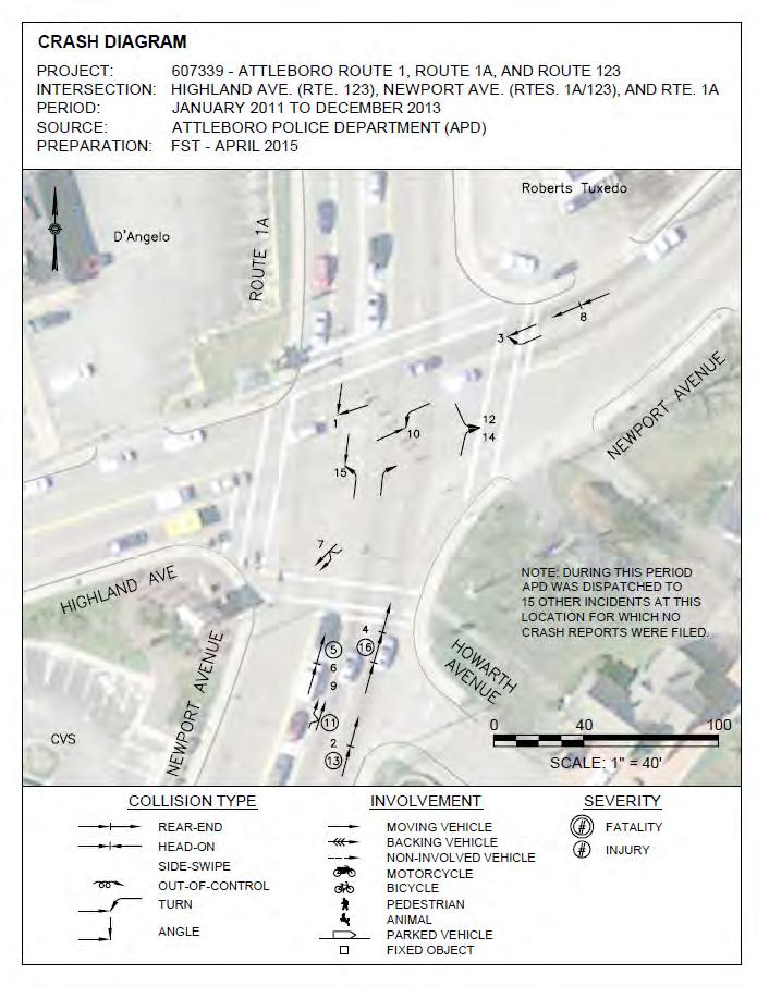
15 Road Safety Audit Route 1, 1A, 123 and May Street Intersections in Attleboro, MA Prepared by FST Pavement Markings and Signs The eastbound right-turn lane should not have a permitted arrow and should have a No- Turn-on-Red sign installed because one of the phases that the permitted right turn would operate on is the northbound left turn phase, which is also used as a U-turn phase as indicted by the curb cut out south of the intersection on the southbound side. Speed Figure 7: Right Turn at May Street Should Have a "No-Turn on Red Sign" Almost 50% of the collisions that occurred at this intersection indicate that the drivers may be speeding or following too closely. Speeding is possibly an issue at this location because of the design speed of the road and the fact that the land use north of this intersection is less dense. Both of these factors make drivers more comfortable driving at higher speeds. Furthermore, speeding may be contributing to rear-end collisions at this location because drivers need more time to break to come to a complete stop if there is an oncoming red light. Multi-Modal Sidewalks, crosswalks and pedestrians crossing are not provided on the east side of Route 1 northbound from Angelina Drive to May Street. A pedestrian signal or crosswalk is not provided on the east side of the May Street approach. Obstructions There were three collisions with fixed objects on the side of the roadway. A likely cause for this is that signs are too close to the roadway. Access Points and Traffic Generators The approaches entering and exiting May Street to the west of the intersection serve the South Attleboro Square Plaza as well as the Arbour Fuller Hospital. Furthermore, the first phase of the development at Shops at Mayfair is proposed to open across the street on the Page 13
16 Road Safety Audit Route 1, 1A, 123 and May Street Intersections in Attleboro, MA Prepared by FST Parking southeast quadrant of the intersection. This will increase traffic and movements in and out of the intersection. Parking is restricted in the intersection and on the roadway approaches to the intersection. Therefore, parking does not contribute to any safety concerns within this intersection. Auxiliary Lanes The queue from the southbound left-turn lane extends into the through lanes. Route 1A and Route 123 Pavement Markings and Signs Speed There is no delineation of the eastbound movements through the intersection. This could also be contributing to the angle collisions that have occurred with east-westbound traffic on Route 123 with north-southbound traffic on Route 1A due to driver confusion Northbound permitted right turn on red- vehicles from the Route 1A approach have had collisions with protected left-turning vehicles from the southbound Route 1A approach. As eastbound traffic is speeding up on Route 123 past the intersection, there is a crossing guard for the Elementary School on Roy Avenue. The curve that exists along this section of Route 123 makes it even more difficult to observe this pedestrian crossing. Multi-Modal There are no shoulders for bicycle accommodation on all of the approaching roadways to the intersection. Ramps do not appear to be ADA compliant. Outdated pedestrian equipment. Intersection Control The westbound approach on Route 123 past the intersection, heading towards Route 1, spills over into the intersection. Obstructions Vegetation on the westbound approach near Robert s Tuxedo is obstructing the lane assignment sign. Page 14
17 Road Safety Audit Route 1, 1A, 123 and May Street Intersections in Attleboro, MA Prepared by FST Following the intersection on Route 123 eastbound, a curve in the roadway obstructs sight lines. Traffic spilling over on approaching roadways can block the driver s view of the signals. Access Points and Traffic Generators Parking D Angelo s, CVS and Mr. Tux all have two redundant driveways. Since parking is restricted at the intersection and on the street at all roadway approaches to the intersection, it does not contribute to a safety issue. Auxiliary Lanes The eastbound through, left-, and right-turn movements are not delineated by pavement markings or signs. Also, the through lanes do not line up to the opposite side on Route 123 eastbound approach. There is no eastbound right-turn lane on Route 123. Potential Safety and Serviceability Enhancements Throughout the RSA, Audit team members voiced ideas about potential transportation that may enhance the safety and serviceability within the RSA project area. Improvements ranged from long term high-cost improvements to short term, low-cost improvements that would offer solutions to the issues observed. The following provides a summary of these recommended transportation improvements. Route 1 and May Street The speeds of vehicles are significantly high in this location. More regulation must be incorporated to establish more control over driver aggression. Multimodal additions are also beneficial. Intersection Control Apply directional pavement markings to guide vehicles safely across the intersection. Obstructions Signs Cut down any vegetation jutting out into the roadway to reduce visual blockage of the oncoming intersection. Relocate signs that obstruct the sight path from all approaches within the intersection. Page 15

18 Road Safety Audit Route 1, 1A, 123 and May Street Intersections in Attleboro, MA Prepared by FST Auxiliary Lanes Lengthen the Route 1 southbound left-turn lane to allow drivers more access and decision time and to accommodate the queuing. Access Points On the May Street eastbound approach, add a no right-turn-on-red only sign to regulate eastbound vehicles turning right. Route 1 and Route 1A Pavement Markings Apply lane markings on the pavement to guide drivers exiting the plaza. And include pavement markings from the plaza driveway eastbound into intersections. Lastly, possibly repave the intersection. Intersection Control Signage Apply directional guidance on pavement to direct vehicles safely through the intersection, particularly on lanes that require exclusive turning movements (e.g. left-turn only lane). Upgrade the pedestrian signal to include a visible countdown. Reconfiguring and squaring the intersection to allow the northbound movement on Route 1A to access the driveway to the South Attleboro Square shopping plaza. Increase the all-red time for traffic signals to improve queue clearance and prevent rear-end collisions Implement more signs that warn drivers about the lane designations at the intersection. Auxiliary Lanes Lengthen the southbound left-turn lane to reduce congestion and trapped vehicles. Figure 8: No Route 123 Eastbound Lane Designations Multi-modal Page 16
19 Road Safety Audit Route 1, 1A, 123 and May Street Intersections in Attleboro, MA Prepared by FST Pedestrian facilities such as sidewalks must be extended along the southeast portion of the intersection at where Route 1A is. Route 1A and Route 123 Pavement Markings Speed Apply lane pavement markings, elephant tracks to guide drivers through the intersection. Possibly repave the road. Repaint the crosswalk to make it more conspicuous to drivers, so that they will be more alert to it and drive more cautiously as a result. Apply more signage that provide more regulation to speed limits on Route 123. Multi-Modal Widen the shoulders of the existing roadway to accommodate bicycle travel. Replace and/or redesign ramps to be ADA compliant Intersection Control Coordinate signal timings with neighboring intersections, specifically with the northbound traffic to Route 1 and the eastbound traffic from Route 1. Obstructions Remove or trim trees obstructing signs on the Route 123 eastbound approach. Access Points Improve driveways in adjacent commercial areas to encourage uniform traffic movement. Eliminate any unnecessary driveway entrances/exits that may interfere with the intersection. Route 1 and Route 123 Multi-modal Replace sidewalks to improve pedestrian safety along the intersection. Specifically, remove unnecessary curb cuts along sidewalks. Reconstruct pedestrian ramps to comply with ADA regulations. Page 17
20 Road Safety Audit Route 1, 1A, 123 and May Street Intersections in Attleboro, MA Prepared by FST Install new pedestrian signal equipment. Updated Bicycle accommodations by either increasing the shoulder length or incorporating sharrows. Install crosswalk markings that are accurately aligned with the intersection geometry. Intersection Control Update the signal timing plan of the intersection so that green times are effectively distributed towards all roadway approaches; this can alleviate traffic queues, which is a major issue here. Access Points The Southeastern Regional Planning and Economic Development District (SRPEDD) did a study documenting all of the curb cuts in the study area. Recommendations of working with business owners to consolidate curb cuts were evaluated. The recommendations in this study should be revisited. An evaluation of locations of curb cuts where left-turns can be eliminated. BJ s driveway is an issue and mitigation for it should be investigated. Evaluate allowing right-turn on red allowed on eastbound traffic. Pavement Markings Elephant track pavement markings placed from Route 123 eastbound to Route 1 northbound along with the same type of pavement markings from Route 123 westbound to Route 1 southbound would guide drivers into their lane, cut down on confusion and make lane delineation more apparent. In addition, clear pavement markings representing distinct turning movements should be installed on all lanes in the approaching roadways Route 1A at Route 123, Route 1A at Route 1 and Route 1 at May Street Intersection Control and Access Points Discussed creating a one-way street pattern among these three intersections. Advantages of this enhancement include reduced delay, driver confusion and conflict points and better access to destinations within the area of these three intersections. These enhancements could all result in reduced crashes and improved safety for all three intersections. This alternative should be evaluated in the proposed design. Page 18
21 Road Safety Audit Route 1, 1A, 123 and May Street Intersections in Attleboro, MA Prepared by FST Summary of Road Safety Audit List each safety issue and potential safety enhancement discussed during the audit. For each safety issue, describe the potential safety enhancement, its potential safety payoff, the estimated time frame for completion, the estimated construction cost, and the responsible agency. If there are conceptual or design plans in progress for this location, identify the potential safety enhancements that have been incorporated into the design. If there are issues with the plans, as designed, this should be noted as well. Safety payoff estimates are subjective and may be based on the relative percent of crashes that may be reduced by the enhancement based on known and documented crash reduction factors, if available, or estimated crash reduction based on a stated source. Table 2: Estimated Time Frame and Costs Breakdown Time Frame Costs Short-Term <1 Year Low <$10,000 Mid-Term 1-3 Years Medium $10,000-$50,000 Long-Term >3 Years High >$50,000 Page 19
22 Road Safety Audit Route 1, 1A, 123 and May Street Intersections in Attleboro, MA Prepared by FST Table 3: Potential Safety Enhancement Summary Route 1 at Route 123 Safety Issue Potential Safety Enhancement Safety Payoff Time Frame Cost Responsible Agency Pavement Markings Apply new pavement markings for turning movements on various lanes. Medium Short Low MassDOT Obstructions Intersection Control Auxiliary Lanes Coordinate with property owners to remove and/or relocate commercial signage that blocks the view of motorists at intersections. Evaluate Lead Green time for traffic signals to improve queue clearance and reduce rear-ends collisions. Right turn on red should not be allowed. Extend the lane merge on Route 123 to the west to avoid interference with the heavily-used driveway for the BJ s Wholesale Club Replace and construct new sidewalks to improve pedestrian safety. Also, remove unnecessary curb cuts along sidewalks Medium Short Low City of Attleboro High Short Low MassDOT High Mid Medium High Long High MassDOT and City of Attleboro MassDOT and City of Attleboro Multi-modal Access Points and Traffic Generators Implement exclusive bike lanes on Rt. 123 to accommodate/improve cyclist safety Medium Mid Low MassDOT Re-apply crosswalk pavement markings to enhance pedestrian guidance across intersection Medium Short Low MassDOT Upgrade the pedestrian signals to include a visible countdown Medium Short Medium MassDOT Reduce and/or combine curb cuts for driveways to adjacent commercial/retail properties. High Mid High City of Attleboro Page 20
23 Road Safety Audit Route 1, 1A, 123 and May Street Intersections in Attleboro, MA Prepared by FST Table 4: Potential Safety Enhancement Summary Route 1 at Route 1A Safety Issue Potential Safety Enhancement Safety Payoff Time Frame Cost Responsible Agency Pavement Markings Obstructions Intersection Control Auxiliary Lanes Multi-modal Signs Apply new pavement markings for turning movements on various lanes. Medium Short Low MassDOT Coordinate with property owners to remove and/or relocate commercial signage that blocks the view of motorists at intersections. Medium Short Low Increase the all-red time for traffic signals to improve queue clearance and prevent further vehicle collisions Improve the signal coordination between adjacent intersections to increase safety and improve mobility. Lengthen left turn lanes/bays to store higher volumes and enhance driver s Medium Mid Medium decision time Replace and construct new sidewalks to improve pedestrian safety. Also, remove unnecessary curb cuts along High Long High sidewalks Reconstruct ramps to comply with ADA regulations Medium Mid Medium City of Attleboro High Short Low MassDOT High Mid Medium MassDOT MassDOT and City of Attleboro MassDOT and City of Attleboro MassDOT and City of Attleboro Upgrade the pedestrian signals to include a visible countdown Medium Short Medium MassDOT Add and relocate highway guide signs to inform drivers about the assigned High Short Low MassDOT directions of each lane. Add signage that warns drivers of an upcoming signalized intersection. Medium Short Low MassDOT Page 21
24 Road Safety Audit Route 1, 1A, 123 and May Street Intersections in Attleboro, MA Prepared by FST Table 4: Potential Safety Enhancement Summary Route 1 at Route 1A (cont.) Safety Issue Potential Safety Enhancement Safety Payoff Time Frame Cost Responsible Agency Access Points and Traffic Generators Reduce and/or combine curb cuts for driveways to adjacent High Mid High City of Attleboro commercial/retail properties. Remove unnecessary curb cuts along City of Attleboro sidewalks High Long High Add a new traffic signal at Angeline Street for the proposed new development area Medium Long High MassDOT Reconfigure Intersection to allow the NB thru movement of Rte 1A to access the shopping center High Long High MassDOT and the City of Attleboro Page 22
25 Road Safety Audit Route 1, 1A, 123 and May Street Intersections in Attleboro, MA Prepared by FST Table 5: Proposed Safety Enhancement Summary - Route 1 at May Street Safety Issue Potential Safety Enhancement Safety Payoff Time Frame Cost Responsible Agency Pavement Markings Apply a new permitted arrow for the eastbound right turn lane Medium Short Low MassDOT Obstructions Coordinate with property owners to remove and/or relocate commercial signage that blocks the view of motorists at intersections. Medium Short Low Trim trees and other vegetation obstruct motorists views of highway guide signs. Low Short Low City of Attleboro City of Attleboro Intersection Control Auxiliary Lanes Multi-modal Signs Access Points and Traffic Generators Speed Increase the all-red time for traffic signals to improve queue clearance and reduce various vehicle collisions. Lengthen left turn lanes/bays to store higher volumes and enhance driver s decision time where applicable. High Short Low MassDOT Medium Mid Medium Add no-turn-on-red signs where applicable. Medium Short Low Replace and construct new sidewalks to improve pedestrian safety. Also, remove unnecessary curb cuts along sidewalks High Long High Install new pedestrian signals that include a visible countdown MassDOT and City of Attleboro MassDOT MassDOT and City of Attleboro Medium Mid High MassDOT Add and relocate highway guide signs to inform drivers about the assigned directions of each lane. High Short Low MassDOT Add signs that warn drivers of an upcoming signalized intersection. Reduce and/or combine curb cuts for driveways to adjacent commercial/retail properties affiliated with the South Attleboro Square Plaza. Discussion of mitigation for the proposed development on Route 1 south of May Street. Medium Short Low MassDOT High Mid High City of Attleboro Increase enforcement and speed regulation signage between adjacent intersections. High Short Low MassDOT Page 23
26 Road Safety Audit Route 1, 1A, 123 and May Street Intersections in Attleboro, MA Prepared by FST Table 6: Proposed Safety Enhancement Summary - Route 1A/Newport Ave and Route 123/Highland Ave Safety Issue Potential Safety Enhancement Safety Payoff Time Frame Cost Responsible Agency Pavement Markings Apply a new permitted arrow for the eastbound right turn lane Medium Short Low MassDOT Obstructions Remove and/or relocate current signs (i.e. commercial type) on the concrete island that may block the view of intersecting roadways Trim vegetation blocking intersection Medium Short Low City of Attleboro Low Short Low City of Attleboro Intersection Control Auxiliary Lanes Multi-modal Access Points and Traffic Generators Increase the all-red time for traffic signals to improve queue clearance High Short Low MassDOT Retime and optimize cycle lengths to improve distribution of green time Apply clear delineation of pavement markings for the eastbound approach Medium Short Low MassDOT Medium Short Low MassDOT Add no-turn-on-red sign that can clearly inform drivers of limited priority when turning right on the eastbound approach Medium Short Low MassDOT Implement bike lanes, ramps and equipment on Rt. 123 to accommodate higher cyclist volumes Medium Mid Low MassDOT Implement constraints and regulations that will enhance safer, uniform traffic flow along nearby driveways High Mid High City of Attleboro Speed Increase signage that incorporate more speed regulation between adjacent intersections High Short Low Add signs that warn drivers of areas with high pedestrian volumes between intersections High Short Low MassDOT and City of Attleboro MassDOT and City of Attleboro Page 24
27 Appendix A. RSA Meeting Agenda
28
29 Route 1 (Washington Street), 1A (Newport Ave), 123 (Highland Ave) and May Street Attleboro Friday May 29, :30 Noon Attleboro South Fire Station 1476 West Street Road Safety Audit Outline Prepared by Heather Ostertog, FST Introductions 8:30AM Welcome and Thanks for coming What is a RSA? A formal safety performance examination of an existing or future road or intersection by an independent audit team. Important to get input from a broad cross section of individuals that are most familiar with the study area including public responders, designers, maintenance staff and pedestrian and bicycle advocacy. Review Agenda Review Existing Conditions Map with ADTs on it Identify signals Identify pedestrian signals and crosswalks Identify the Middle School Identify traffic volumes Operations o AM Peak Hour LOS C or better o AM Queues Ok o PM Peak Hour LOS is D or better. D at Newport Ave and Highland Avenue and C at Washington Street at May Street. o PM Queues WB Left queue from Highland to Washington spills out of pocket. EB queue at Washington and May Street possible problem? SB Left queue at Washington Street and Newport Avenue Connector. o Saturday Peak Hour LOS Washington Street at Newport Avenue Connector. SB left turn and EB left turn LOS F. Overall LOS F and overall delay of 100 seconds. Washington and May Street. EB and SB left LOS F. Overall LOS E and delay of 70 seconds. Other two intersections operate at LOS C. o Saturday Queues EB Washington at May Street spill over in the through lane. SB left spill over from left turn lane. SB Left at Washington and Newport Connector spill over. Crashes o HSIP High Crash Locations Washington Street at May Street and Washington Street at Highland Avenue (Top 200 Intersection Crash Location Statewide) o 128 Total reported crashes in 3 years o Crash Trends by Location
30 o Washington at Highland Driveways, rear-ends, left turns, sideswipes pedestrian in crosswalk o Highland at Newport Left turns and rear-ends o Washington at Newport Ave Connector Left turns and rear-ends o Washington at May Street Rear-end, Single Vehicle crashes, bicycle crash Talk About Field Visit o Purpose? To ID the issues that impact safety o What to look for? Review Prompt List Field Visit 9:30AM 10:45AM o Thoughts and personal experiences on how location operates o Thoughts from your professional knowledge and expertise Post Visit 11:00 AM - Noon o ID issues o SOLUTIONS Short/Medium/Long Term
31 Appendix B. RSA Audit Team Contact List
32 Participating Audit Team Members Date: September 15, 2015 Location: Attleboro, MA Audit Team Members Agency/Affiliation Address Phone Number Ron Dubuc Walter Thibodeau Dennis Perkins Kyle Heagney John Mastera Edward Feeney Nitza Otero Attleboro Dept. of Public Works - Highway Division Attleboro Municipal Council Attleboro Fire Dept. Attleboro Police Dept. (ADP) MassDOT Highway Division MassDOT Highway Division District 5 MassDOT - MassRIDES Safe Routes to School dpw2@cityofattleboro. us walterthibodeau2@aol. com fireprevention@cityofa ttleboro.us kheagney@attleboropo lice.org john.mastera@dot.stat e.ma.us edward.feeney@state. ma.us nitza.otero@dot.state. ma.us x Jacqueline Schmidt SRPEDD jschmidt@srpedd.org x234 Patrick Dunford Sarah Borenstein Heather Ostertog William Ullom Stephanie Davies Gary Agrassian Richard Oliveira Vanasse Hangen Brustlin (VHB) Fay, Spofford & Thorndike Fay, Spofford & Thorndike MassDOT Highway Division City of Attleboro, Planning City of Attleboro, Planning MassDOT Highway Division District 5 pdunford@vhb.com sborenstein@fstinc.co m hostertog@fstinc.com william.ullom@state.m a.us seniorplanner@cityofat tleboro.us cityplanner@cityofattle boro.us Richard.oliveira@state. ma.us x x
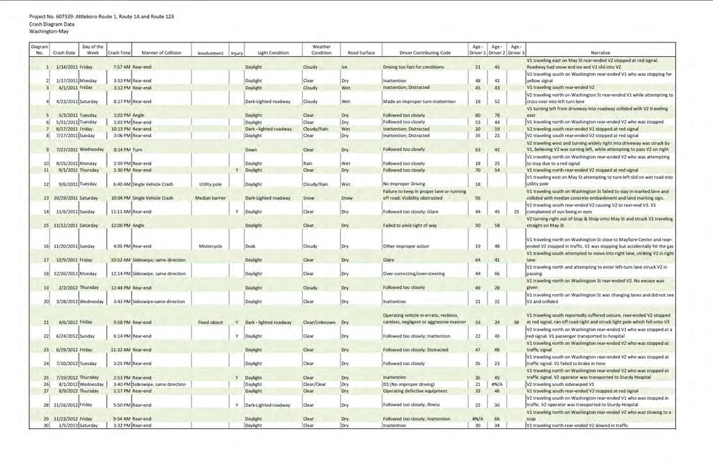
33 Appendix C. Detailed Crash Data

34
35
36
37
38
39
40
41
42
43
44 Appendix D. Additional Information
45
46
47
48
49
50 Appendix E. Road Safety Audit References
51 Road Safety Audit References Massachusetts Traffic Safety Toolbox, Massachusetts Highway Department, Road Safety Audits, A Synthesis of Highway Practice. NCHRP Synthesis 336. Transportation Research Board, National Cooperative Highway Research Program, Road Safety Audits. Institute of Transportation Engineers and U.S. Department of Transportation, Federal Highway Administration, FHWA Road Safety Audit Guidelines. U.S. Department of Transportation, Federal Highway Administration, Road Safety Audit, 2 nd edition. Austroads, Road Safety Audits. ITE Technical Council Committee 4S-7. Institute of Transportation Engineers, February 1995.
ROAD SAFETY AUDIT. State Road (Route 6) Corridor Town of Dartmouth. March Prepared For: MassDOT
 Corridor Town of Dartmouth. March Prepared For: MassDOT") ROAD SAFETY AUDIT State Road (Route 6) Corridor Town of Dartmouth March 2015 Prepared For: MassDOT Prepared By: McMahon Associates, Inc. 300 Myles Standish Blvd. Suite 201 Taunton, MA 02780 Table of Contents
ROAD SAFETY AUDIT State Road (Route 6) Corridor Town of Dartmouth March 2015 Prepared For: MassDOT Prepared By: McMahon Associates, Inc. 300 Myles Standish Blvd. Suite 201 Taunton, MA 02780 Table of Contents
ROAD SAFETY AUDIT. East Main Street (Route 123) at Route I-495 Northbound & Southbound Ramps Town of Norton. May 11, Prepared For: MassDOT
 at Route I-495 Northbound & Southbound Ramps Town of Norton. May 11, Prepared For: MassDOT") ROAD SAFETY AUDIT East Main Street (Route 123) at Route I-495 Northbound & Southbound Ramps Town of Norton May 11, 2016 Prepared For: MassDOT Prepared By: 101 Walnut Street Watertown, MA Road Safety Audit
ROAD SAFETY AUDIT East Main Street (Route 123) at Route I-495 Northbound & Southbound Ramps Town of Norton May 11, 2016 Prepared For: MassDOT Prepared By: 101 Walnut Street Watertown, MA Road Safety Audit
Route 28 (South Orleans Road)/Route 39 (Harwich Road)/Quanset Road Intersection
/Route 39 (Harwich Road)/Quanset Road Intersection") TRAFFIC FEASIBILITY STUDY Route 28 (South Orleans Road)/Route 39 (Harwich Road)/Quanset Road Intersection Orleans, Massachusetts Prepared for: Town of Orleans Prepared by: Fay, Spofford & Thorndike, LLC
TRAFFIC FEASIBILITY STUDY Route 28 (South Orleans Road)/Route 39 (Harwich Road)/Quanset Road Intersection Orleans, Massachusetts Prepared for: Town of Orleans Prepared by: Fay, Spofford & Thorndike, LLC
ROAD SAFETY AUDIT. Centre Street (Route 123) at Plymouth Street. Municipality of Brockton. November, Prepared For: MassDOT
 at Plymouth Street. Municipality of Brockton. November, Prepared For: MassDOT") ROAD SAFETY AUDIT Centre Street (Route 123) at Plymouth Street Municipality of Brockton November, 2017 Prepared For: MassDOT On Behalf Of: City of Brockton Prepared By: Old Colony Planning Council 70 School
ROAD SAFETY AUDIT Centre Street (Route 123) at Plymouth Street Municipality of Brockton November, 2017 Prepared For: MassDOT On Behalf Of: City of Brockton Prepared By: Old Colony Planning Council 70 School
ROAD SAFETY AUDIT. Blue Hill Avenue (Route 28) and Warren Street High Crash Locations City of Boston. November 1, 2016
 and Warren Street High Crash Locations City of Boston. November 1, 2016") ROAD SAFETY AUDIT Blue Hill Avenue (Route 28) and Warren Street High Crash Locations City of Boston November 1, 2016 Prepared For: MassDOT Highway Division Prepared By: BETA Group, Inc. Table of Contents
ROAD SAFETY AUDIT Blue Hill Avenue (Route 28) and Warren Street High Crash Locations City of Boston November 1, 2016 Prepared For: MassDOT Highway Division Prepared By: BETA Group, Inc. Table of Contents
ROAD SAFETY AUDIT. County Street at Hart Street. City of Taunton. January 30, Prepared For: Massachusetts Department of Transportation
 ROAD SAFETY AUDIT County Street at Hart Street City of Taunton January 30, 2015 Prepared For: Massachusetts Department of Transportation Prepared By: Toole Design Group 33 Broad Street, 4 th Floor Boston,
ROAD SAFETY AUDIT. Granite Avenue at Interstate 93 Ramps. Town of Milton. May 22, Prepared for: MassDOT
 ROAD SAFETY AUDIT Granite Avenue at Interstate 93 Ramps Town of Milton May 22, 2017 Prepared for: MassDOT Prepared by: Toole Design Group 2 Oliver Street, Suite 305 Boston, MA 02109 Table of Contents Background...
Ottawa Beach Road Study
 Ottawa Beach Road Study Prepared For: Park Township September 30, 2014 Project No. G140303 OTTAWA BEACH ROAD STUDY PREPARED FOR: PARK TOWNSHIP SEPTEMBER 30, 2014 PROJECT NO. G140303 TABLE OF CONTENTS 1.0
ROAD SAFETY AUDIT. Route 114 at Interstate I-495 Northbound Ramps. City of Lawrence. July 30, 2015
 ROAD SAFETY AUDIT Route 114 at Interstate I-495 Northbound Ramps City of Lawrence July 30, 2015 Prepared For: Massachusetts Department of Transportation Prepared By: Toole Design Group 33 Broad Street,
Draft North Industrial Area-Wide Traffic Plan
 Summary of North Industrial and Hudson Bay Industrial Recommended Improvements Table 1. Summary of s Item Location 1 2 3 4 5 6 7 8 9 10 11 12 Millar Ave north of 51st St Super 8 Motel back lane 400 Block
ROAD SAFETY AUDIT. May 18, Prepared For: MassDOT. On Behalf Of: Town of Milford
 ROAD SAFETY AUDIT East Main Street (Route 16) at Medway Road (Route 109), East Main Street (Route 16) at Quarry Square Driveways, East Main Street (Route 16) at Beaver Street/ Fortune Boulevard Town of
ROAD SAFETY AUDIT. Providence Street (Route 122A) at McKeon Road/Millbury Street. City of Worcester. July 14, Prepared For: MassDOT
 at McKeon Road/Millbury Street. City of Worcester. July 14, Prepared For: MassDOT") ROAD SAFETY AUDIT Providence Street (Route 122A) at McKeon Road/Millbury Street City of Worcester July 14, 2016 Prepared For: MassDOT Prepared By: Stantec Consulting Services, Inc. Burlington, Massachusetts
ROAD SAFETY AUDIT Providence Street (Route 122A) at McKeon Road/Millbury Street City of Worcester July 14, 2016 Prepared For: MassDOT Prepared By: Stantec Consulting Services, Inc. Burlington, Massachusetts
Date: April 4, Project #: Re: A Street/Binford Street Traffic/Intersection Assessment
 To: Peter Cavanaugh General Electric From: David Bohn, PE Ryan White, PE Date: April 4, 217 Project #: 13421. Re: / Traffic/Intersection Assessment Consistent with the Cooperation Agreement between the
FLORIDA DEPARTMENT OF TRANSPORTATION DISTRICT 7 DISTRICT WIDE BICYCLE/PEDESTRIAN ACCESS TO TRANSIT SAFETY ASSESSMENT AND IMPROVEMENT PLAN
 FLORIDA DEPARTMENT OF TRANSPORTATION DISTRICT 7 DISTRICT WIDE BICYCLE/PEDESTRIAN ACCESS TO TRANSIT SAFETY ASSESSMENT AND IMPROVEMENT PLAN TRANSIT SAFETY ASSESSMENT SR 55/US 19 AT 80 TH AVE N DRAFT JUNE
ROAD SAFETY AUDIT. Route 16 at Interstate 395 Town of Webster. October Prepared For: MassDOT
 ROAD SAFETY AUDIT Route 16 at Interstate 395 Town of Webster October 2015 Prepared For: MassDOT Prepared By: McMahon Associates, Inc. 300 Myles Standish Blvd. Suite 201 Taunton, MA 02780 Table of Contents
Forest Hills Improvement Initiative
 Forest Hills Improvement Initiative Transportation Action Plan Short Term Recommendations ONLY Final Draft as of April 30, 2008 For Community Review and Feedback Prepared for: The City of Boston Boston
ROAD SAFETY AUDIT. Route 38 from Route 62 to Woburn Town Line. Town of Wilmington. April 10, Prepared For: MassDOT
 ROAD SAFETY AUDIT Route 38 from Route 62 to Woburn Town Line Town of Wilmington April 10, 2017 Prepared For: MassDOT Prepared By: Green International Affiliates, Inc. 239 Littleton Road, Suite 3, Westford,
Orange Center Elementary School
 Drag and drop pic and stretch/crop to the limits of the blue rectangle (delete this text box) Orange Center Elementary School Drag and drop pic and stretch/crop to the limits of the blue rectangle (delete
ROAD SAFETY AUDIT. Route 202 (East State Street)/School Street & Route 202 (West State Street)/Pleasant Street/Amherst Street Town of Granby
/School Street & Route 202 (West State Street)/Pleasant Street/Amherst Street Town of Granby") ROAD SAFETY AUDIT Route 202 (East State Street)/School Street & Route 202 (West State Street)/Pleasant Street/Amherst Street Town of Granby March 2013 Prepared for: Massachusetts Department of Transportation
ROAD SAFETY AUDIT Route 202 (East State Street)/School Street & Route 202 (West State Street)/Pleasant Street/Amherst Street Town of Granby March 2013 Prepared for: Massachusetts Department of Transportation
Traffic Study of Fuller Street, Cady Street, West Street and West Avenue. Final Report
 Traffic Study of Fuller Street, Cady Street, West Street and West Avenue Final Report July 2005 Prepared for: Town of Ludlow Prepared by: Pioneer Valley Planning Commission 26 Central Street West Springfield,
TRAFFIC ACTION PLAN. Laurie Meadows Neighborhood CITY OF SAN MATEO
 TRAFFIC ACTION PLAN Laurie Meadows Neighborhood CITY OF SAN MATEO Draft January 2017 Table of Contents Introduction... 2 The Traffic Forum Process... 5 Neighborhood Traffic Issues... 7 Neighborhood Recommendations
MEMORANDUM. Layout Of Study Intersections And Traffic Control
 BOSTON REGION METROPOLITAN PLANNING ORGANIZATION Richard A. Davey, MassDOT Secretary and CEO and MPO Chairman Karl H. Quackenbush, Executive Director, MPO Staff DATE November 15, 2012 TO FROM RE Town of
A plan for improved motor vehicle access on Railroad Avenue in Provincetown
 A plan for improved motor vehicle access on Railroad Avenue in Provincetown February 2011 A plan for improved motor vehicle access on Railroad Avenue in Provincetown INTRODUCTION AND PROBLEM IDENTIFICATION
Traffic Impact Analysis Chatham County Grocery Chatham County, NC
 Chatham County Grocery Chatham County, NC TABLE OF CONTENTS 1. INTRODUCTION... 1 1.1. Location and Study Area... 1 1.2. Proposed Land Use and Access... 2 1.3. Adjacent Land Uses... 2 1.4. Existing ways...
Windy Ridge Elementary School
 Windy Ridge Elementary School SCHOOL ROUTE PLAN For WINDY RIDGE ELEMENTARY SCHOOL LOCATION 54 ORANGE COUNTY Prepared for: ORANGE COUNTY SCHOOL ASSESSMENT PROGRAM ORANGE COUNTY PUBLIC WORKS Traffic Engineering
ROAD SAFETY AUDIT. Route 113 (Storey Avenue) at Woodman Way and Low Street. Newburyport, MA. May 27, Prepared For: MassDOT
 at Woodman Way and Low Street. Newburyport, MA. May 27, Prepared For: MassDOT") ROAD SAFETY AUDIT Route 113 (Storey Avenue) at Woodman Way and Low Street Newburyport, MA May 27, 2015 Prepared For: MassDOT Prepared By: Bayside Engineering, Inc. 600 Unicorn Park Drive Woburn, MA 01801
ROAD SAFETY AUDIT Route 113 (Storey Avenue) at Woodman Way and Low Street Newburyport, MA May 27, 2015 Prepared For: MassDOT Prepared By: Bayside Engineering, Inc. 600 Unicorn Park Drive Woburn, MA 01801
ROAD SAFETY AUDIT. Santilli Circle and Sweetser Circle. Municipality of Everett. March 10, Prepared For: MassDOT
 ROAD SAFETY AUDIT Santilli Circle and Sweetser Circle Municipality of Everett Prepared For: MassDOT On Behalf Of: WYNN Design and Development Prepared By: AECOM 250 Apollo Drive Chelmsford, MA Road Safety
MT. LEBANON COMPREHENSIVE PLAN UPDATE ELEVATING CONNECTIVITY FOR PEDESTRIANS AND CYCLISTS
 MT. LEBANON COMPREHENSIVE PLAN UPDATE ELEVATING CONNECTIVITY FOR PEDESTRIANS AND CYCLISTS Municipality of Mt. Lebanon, Allegheny County, Pennsylvania INTRODUCTION The Mt. Lebanon Comprehensive Plan Update
Improving Cyclist Safety at the Dundas Street West and Sterling Road Intersection
 STAFF REPORT ACTION REQUIRED Improving Cyclist Safety at the Dundas Street West and Sterling Road Intersection Date: August 17, 2012 To: From: Wards: Reference Number: Public Works and Infrastructure Committee
HIGHBURY AVENUE/HAMILTON ROAD INTERSECTION IMPROVEMENTS PUBLIC INFORMATION CENTRE 1 MAY 14, 2015
 HIGHBURY AVENUE/HAMILTON ROAD INTERSECTION IMPROVEMENTS Municipal Class Environmental Assessment PUBLIC INFORMATION CENTRE 1 MAY 14, 2015 ACCESSIBILITY Under the Accessibility Standards 2015 for Customer
Public Information Centre
 WELCOME Public Information Centre Father Tobin Road Lougheed Middle School - Library Wednesday November 7, 2012 7:00 p.m.to 9:00 p.m. Please sign in Neighbourhood Traffic Calming Guide Background The City
ROAD SAFETY AUDIT. Boston Road (Route 20) at Parker Street and Pasco Road to Dumaine Street City of Springfield Town of Wilbraham.
 at Parker Street and Pasco Road to Dumaine Street City of Springfield Town of Wilbraham.") ROAD SAFETY AUDIT Boston Road (Route 2) at Parker Street and Pasco Road to Dumaine Street City of Springfield Town of Wilbraham October 4, 212 Prepared For: MassDOT Highway Division Prepared By: BETA Group,
ROAD SAFETY AUDIT Boston Road (Route 2) at Parker Street and Pasco Road to Dumaine Street City of Springfield Town of Wilbraham October 4, 212 Prepared For: MassDOT Highway Division Prepared By: BETA Group,
ROAD SAFETY AUDIT. Damon Road. City of Northampton. October Prepared for: Massachusetts Department of Transportation
 ROAD SAFETY AUDIT Damon Road City of Northampton October 2013 Prepared for: Massachusetts Department of Transportation Prepared by: Howard/Stein-Hudson Associates 38 Chauncy Street Boston, MA 02111 Table
Overview. Updated pictures of the intersection are shown in Exhibits 1 thru 4, and the aerial photo provided by Google Maps is shown in Exhibit 5.
 Overview The (here in after referred to as the Village ) is submitting the follow up interim RLRC Safety Report for the intersection of Lincoln Highway (US 30) at Orchard Drive. Additional reports, as
Multi-Modal Traffic Analysis. Parisi and Associates
 Mill Valley to Corte Madera Bicycle and Pedestrian Corridor Study Appendix D: Multi-Modal Traffic Analysis Prepared by Parisi and Associates August 2009 Appendix D - Multi-Modal Traffic Analysis Table
DEPARTMENT OF ENVIRONMENTAL SERVICES. North Harrison Street (Lee Highway to Little Falls Road) Comparative Analysis. Prepared for:
 Comparative Analysis. Prepared for:") DEPARTMENT OF ENVIRONMENTAL SERVICES North Harrison Street (Lee Highway to Little Falls Road) Comparative Analysis Prepared for: Arlington County Department of Environmental Services 2100 Clarendon Boulevard,
DEPARTMENT OF ENVIRONMENTAL SERVICES North Harrison Street (Lee Highway to Little Falls Road) Comparative Analysis Prepared for: Arlington County Department of Environmental Services 2100 Clarendon Boulevard,
AGENDA ITEM 6 D THOMASVILLE ROAD (HERMITAGE BOULEVARD TO LIVE OAK PLANTATION ROAD) ROADWAY SAFETY AUDIT
 ROADWAY SAFETY AUDIT") May 15, 2018 AGENDA ITEM 6 D THOMASVILLE ROAD (HERMITAGE BOULEVARD TO LIVE OAK PLANTATION ROAD) ROADWAY SAFETY AUDIT TYPE OF ITEM: Discussion STATEMENT OF ISSUE The Florida Department of Transportation
May 15, 2018 AGENDA ITEM 6 D THOMASVILLE ROAD (HERMITAGE BOULEVARD TO LIVE OAK PLANTATION ROAD) ROADWAY SAFETY AUDIT TYPE OF ITEM: Discussion STATEMENT OF ISSUE The Florida Department of Transportation
ROAD SAFETY AUDIT. Route 3A from Evans Street to Abigail Adams State Park. Town of Weymouth. October 12, Prepared For: MassDOT
 ROAD SAFETY AUDIT Route 3A from Evans Street to Abigail Adams State Park Town of Weymouth October 12, 2016 Prepared For: MassDOT Prepared By: Green International Affiliates, Inc. 239 Littleton Road, Suite
Capital Region Council of Governments
 March 23, 2018 Capital Region Council of Governments PROJECT CONCEPT REPORT Realignment of Swamp and Northfield Road s approaches to Route 44 (Boston Turnpike) Town of Coventry SUMMARY: The Town of Coventry
ROAD SAFETY AUDIT. West Central Street (Route 140) at Franklin Village Drive. Town of Franklin. February 03, 2016
 at Franklin Village Drive. Town of Franklin. February 03, 2016") ROAD SAFETY AUDIT West Central Street (Route 140) at Franklin Village Drive Town of Franklin February 03, 2016 Prepared for: Massachusetts Department of Transportation Prepared by: Howard Stein Hudson
ROAD SAFETY AUDIT West Central Street (Route 140) at Franklin Village Drive Town of Franklin February 03, 2016 Prepared for: Massachusetts Department of Transportation Prepared by: Howard Stein Hudson
M-58 HIGHWAY ACCESS MANAGEMENT STUDY Mullen Road to Bel-Ray Boulevard. Prepared for CITY OF BELTON. May 2016
 M-58 HIGHWAY ACCESS MANAGEMENT STUDY Prepared for CITY OF BELTON By May 2016 Introduction Missouri State Highway 58 (M-58 Highway) is a major commercial corridor in the City of Belton. As development has
Evaluation of M-99 (Broad Street) Road Diet and Intersection Operational Investigation
 Road Diet and Intersection Operational Investigation") Evaluation of M-99 (Broad Street) Road Diet and Intersection Operational Investigation City of Hillsdale, Hillsdale County, Michigan June 16, 2016 Final Report Prepared for City of Hillsdale 97 North Broad
Evaluation of M-99 (Broad Street) Road Diet and Intersection Operational Investigation City of Hillsdale, Hillsdale County, Michigan June 16, 2016 Final Report Prepared for City of Hillsdale 97 North Broad
Road Safety Audit for the Intersection of VFW Highway & Bridge Street in Lowell, Massachusetts
 Road Safety Audit for the Intersection of VFW Highway & Bridge Street in Lowell, Massachusetts Prepared by University of Massachusetts Traffic Safety Research Program Prepared for Massachusetts Highway
Active Transportation Facility Glossary
 Active Transportation Facility Glossary This document defines different active transportation facilities and suggests appropriate corridor types. Click on a facility type to jump to its definition. Bike
Bicycle RSAs: How to Conduct Road Safety Audits and How to Use Them to Promote Bicyclist Safety. Dan Nabors, PE, VHB Bill DeSantis, PE, VHB
 PBIC Webinar Bicycle RSAs: How to Conduct Road Safety Audits and How to Use Them to Promote Bicyclist Safety [IMAGE] Dan Nabors, PE, VHB Bill DeSantis, PE, VHB Sept. 26, 2013, 2 pm Today s Presentation
Broad Street Bicycle Boulevard Design Guidelines
 Broad Street Bicycle Boulevard Design Guidelines Building from the strategies introduced in the 2013 Bicycle Transportation Plan and community input received thus far, City Transportation Staff have identified
Comments EXECUTIVE SUMMARY
 Comments 1. Under any Alternatives, MCDOT should provide better at-grade pedestrian crossing of Georgia Avenue and Forest Glen Road, including improved crosswalks with wider medians and adequate signal
ROAD SAFETY AUDIT. Route 135 at Route 30 Town of Westborough. January Prepared For: MassDOT
 ROAD SAFETY AUDIT Route 135 at Route 30 January 2016 Prepared For: MassDOT Prepared By: McMahon Associates, Inc. 300 Myles Standish Blvd. Suite 201 Taunton, MA 02780 Road Safety Audit Route 135 at Route
Bay to Bay Boulevard Complete Streets Project
 Bay to Bay Boulevard Complete Streets Project Dale Mabry Highway to Bayshore Boulevard February 08, 2018 Photo Source: Tampa Bay Times Alessandra Da Pra Meeting Format Introduction Resurfacing Information
ROAD SAFETY AUDIT. Mass Pike Interchange 6, I-291 and Burnett Road. City of Chicopee. November 4, Prepared For: MassDOT Highway Division
 ROAD SAFETY AUDIT Mass Pike Interchange 6, I-291 and Burnett Road City of Chicopee November 4, 2013 Prepared For: MassDOT Highway Division Prepared By: BETA Group, Inc. Table of Contents Project Data...
ROAD SAFETY AUDIT. Auburn Street at Southbridge Street (Route 12) Town of Auburn. March Prepared For: Massachusetts Department of Transportation
 Town of Auburn. March Prepared For: Massachusetts Department of Transportation") ROAD SAFETY AUDIT Auburn Street at Southbridge Street (Route 12) Town of Auburn March 2017 Prepared For: Massachusetts Department of Transportation Prepared By: Vanasse Hangen Brustlin, Inc Union Station
ROAD SAFETY AUDIT Auburn Street at Southbridge Street (Route 12) Town of Auburn March 2017 Prepared For: Massachusetts Department of Transportation Prepared By: Vanasse Hangen Brustlin, Inc Union Station
WELCOME Public Information Centre
 WELCOME Public Information Centre Fernforest Drive Brampton Soccer Centre Community Room #2 Tuesday January 19, 2016 6:30 p.m.to 9:00 p.m. Please sign in Neighbourhood Traffic Calming Guide Background
Falmouth Road Safety Audit
 Falmouth Road Safety Audit Sandwich Road: Carriage Shop Road to Hatchville Road September 2011 Prepared by the Cape Cod Commission in cooperation with the Town of Falmouth and Massachusetts Department
Edgemont Village Traffic and Parking Technical Report January 2014
 Edgemont Village Traffic and Parking Technical Report January 2014 In the fall of 2013, the District of North Vancouver engaged consultants to assess existing intersection and parking conditions in Edgemont
CITY OF WEST LAKE HILLS. Forest View Neighborhood Traffic Calming Study
 CITY OF WEST LAKE HILLS 901 South Mopac Expressway Building V, Suite 220 Austin, Texas 78746 Texas P.E. Firm Registration No. F-929 Klotz Associates Final Report Submittal: March 20, 2015 Revised Final
Access Location, Spacing, Turn Lanes, and Medians
 Design Manual Chapter 5 - Roadway Design 5L - Access Management 5L-3 Access Location, Spacing, Turn Lanes, and Medians This section addresses access location, spacing, turn lane and median needs, including
Chapter 2: Standards for Access, Non-Motorized, and Transit
 Standards for Access, Non-Motorized, and Transit Chapter 2: Standards for Access, Non-Motorized, and Transit The Washtenaw County Access Management Plan was developed based on the analysis of existing
Washington St. Corridor Study
 FIGURE 7.17 Bridge Alternatives - Cross Sections 86 Discarded Alternative: Short-Term Bridge Repair Short-term repairs and west bridge span replacement were considered during analysis. Short-term repairs
Meeting Schedule 7:00-7:15 Open House 7:15-7:45 Existing Conditions/Short-Term Improvements Study Presentation 7:45-8:00 Q&A Session 8:00-8:10
 Meeting Schedule 7:00-7:15 Open House 7:15-7:45 Existing Conditions/Short-Term Improvements Study Presentation 7:45-8:00 Q&A Session 8:00-8:10 Long-Term Study Presentation 8:10-8:40 Table Discussions 8:40-9:00
Meadow Woods Elementary School
 Drag and drop pic and stretch/crop to the limits of the blue rectangle (delete this text box) Meadow Woods Elementary School Drag and drop pic and stretch/crop to the limits of the blue rectangle (delete
ROAD SAFETY AUDIT. Water Street (Route 129) at Vernon Street. Town of Wakefield. September Prepared For: MassDOT
 at Vernon Street. Town of Wakefield. September Prepared For: MassDOT") ROAD SAFETY AUDIT Water Street (Route 129) at Vernon Street September 2017 Prepared For: MassDOT Massachusetts Department of Transportation Prepared By: WorldTech Engineering Road Safety Audit Water Street
ROAD SAFETY AUDIT Water Street (Route 129) at Vernon Street September 2017 Prepared For: MassDOT Massachusetts Department of Transportation Prepared By: WorldTech Engineering Road Safety Audit Water Street
ROAD SAFETY AUDIT. Plain Street (Route 139) at Furnace Street and Proprietors Drive Town of Marshfield. June 9, 2017.
 at Furnace Street and Proprietors Drive Town of Marshfield. June 9, 2017.") ROAD SAFETY AUDIT Plain Street (Route 139) at Furnace Street and Proprietors Drive Town of Marshfield June 9, 2017 Prepared for: MassDOT On Behalf of: Vanasse & Associates, Inc. 35 New England Business
ROAD SAFETY AUDIT Plain Street (Route 139) at Furnace Street and Proprietors Drive Town of Marshfield June 9, 2017 Prepared for: MassDOT On Behalf of: Vanasse & Associates, Inc. 35 New England Business
MEMORANDUM. DATE March 1, 2012 TO Town of Milton Mark Abbott, Seth Asante, and Efi Pagitsas Boston Region MPO Staff
 MEMORANDUM DATE March 1, 212 TO Town of Milton FROM RE Mark Abbott, Seth Asante, and Efi Pagitsas Boston Region MPO Staff FFY 211 Safety and Operations Analyses at Selected Boston Region MPO Intersections:
ROAD SAFETY AUDIT. Washington Street (Route 53) at Pleasant Street. Town of Pembroke. June 26, Prepared For: MassDOT Highway Division
 at Pleasant Street. Town of Pembroke. June 26, Prepared For: MassDOT Highway Division") ROAD SAFETY AUDIT Washington Street (Route 53) at Pleasant Street Town of Pembroke June 26, 2014 Prepared For: MassDOT Highway Division Prepared By: BETA Group, Inc. Table of Contents Project Data... 1
ROAD SAFETY AUDIT Washington Street (Route 53) at Pleasant Street Town of Pembroke June 26, 2014 Prepared For: MassDOT Highway Division Prepared By: BETA Group, Inc. Table of Contents Project Data... 1
BOSTON REGION METROPOLITAN PLANNING ORGANIZATION
 PLANNING ORGANIZATIO BOSTON REGION MPO NMETROPOLITAN BOSTON REGION METROPOLITAN PLANNING ORGANIZATION Stephanie Pollack, MassDOT Secretary and CEO and MPO Chair Karl H. Quackenbush, Executive Director,
sm1 CDMth '}lf!j1i!~~!2q[ ROAD SAFETY AUDIT County Street City of New Bedford March 22, 2017 Prepared For: MassDOT
 ROAD SAFETY AUDIT County Street City of New Bedford March 22, 2017 '}lf!j1i!~~!2q[ ~ j ighway Divl.sion Prepared For: MassDOT On Behalf Of: City of New Bedford Massachusetts Prepared By: CDM Smith 260
CITY OF LOS ANGELES INTER-DEPARTMENTAL MEMORANDUM
 CITY OF LOS ANGELES INTER-DEPARTMENTAL MEMORANDUM Date: April 1, 219 To: Honorable City Council c/o City Clerk, Room 395, City Hall Attention: Honorable Mike Bonin, Chair, Transportation Committee From:
Route 117 Review of Ownership Transfer October 2014
 Route 117 Review of Ownership Transfer October 2014 Page 1 of 27 I. INTRODUCTION... 3 II. EXISTING CONDITIONS... 4 A. Town of Lancaster Site-Investigation... 4 B. Town of Bolton Site-Investigation... 9
CURBSIDE ACTIVITY DESIGN
 5 CURBSIDE ACTIVITY DESIGN This chapter provides design guidance for separated bike lanes adjacent to curbside activities including parking, loading and bus stops. Typical configurations are presented
COWETA HIGH SCHOOL AND EAST HIGHWAY 51
 COWETA HIGH SCHOOL AND EAST HIGHWAY 51 Lack of sidewalks along Ben Lumpkin Rd. Lack of crosswalks and ramps at intersection. Hwy 51 is wide to cross as a pedestrian. No ADA compliance or connection to
Harrah s Station Square Casino
 Transportation Analysis Harrah s Station Square Casino Pittsburgh, Pennsylvania Submitted To: City of Pittsburgh and Pennsylvania Gaming Control Board Prepared By: DKS Associates GAI Consultants December
Date: September 7, Project #: Re: Spaulding Youth Center Northfield, NH Property. Traffic Impact Study
 To: Ms. Susan C. Ryan Spaulding Youth Center 72 Spaulding Road Northfield, NH 03276 Date: September 7, 2017 Project #: 52455.00 From: Robin Bousa Director of Transportation Systems Re: Spaulding Youth
Walmart (Store # ) 60 th Street North and Marion Road Sioux Falls, South Dakota
 60 th Street North and Marion Road Sioux Falls, South Dakota") Walmart (Store #4865-00) 60 th Street North and Marion Road Sioux Falls, South Dakota Prepared for: Wal-Mart Stores, Inc. Bentonville, Arkansas Prepared by: Kimley-Horn and Associates, Inc. ã2013 Kimley-Horn
Walmart (Store #4865-00) 60 th Street North and Marion Road Sioux Falls, South Dakota Prepared for: Wal-Mart Stores, Inc. Bentonville, Arkansas Prepared by: Kimley-Horn and Associates, Inc. ã2013 Kimley-Horn
WELCOME. Stakeholder Involvement Group Meeting #2 Round Lake Public Works October 24, 2018
 WELCOME Stakeholder Involvement Group Meeting #2 Round Lake Public Works October 24, 2018 MEETING AGENDA 1. Welcome and Introductions 2. Study Progress Update 3. Problem Statement 4. Technical Analysis
Off-road Trails. Guidance
 Off-road Trails Off-road trails are shared use paths located on an independent alignment that provide two-way travel for people walking, bicycling, and other non-motorized users. Trails specifically along
METHODOLOGY. Signalized Intersection Average Control Delay (sec/veh)
") Chapter 5 Traffic Analysis 5.1 SUMMARY US /West 6 th Street assumes a unique role in the Lawrence Douglas County transportation system. This principal arterial street currently conveys commuter traffic
Chapter 5 Traffic Analysis 5.1 SUMMARY US /West 6 th Street assumes a unique role in the Lawrence Douglas County transportation system. This principal arterial street currently conveys commuter traffic
Route 28 Centerville-Hyannis Corridor Study
 Route 28 Centerville-Hyannis Corridor Study Old Stage Road to Bearses Way February 2016 Barnstable Route 28 Old Stage Road to Bearses Way 2016 This page intentionally left blank Barnstable Route 28 Old
C/CAG. Sunnybrae Elementary School Walking and Bicycling Audit. San Mateo-Foster City School District JUNE 2013
 Sunnybrae Elementary School Walking and Bicycling Audit JUNE 2013 San Mateo-Foster City School District C/CAG City/County Association of Governments of San Mateo County SUNNYBRAE ELEMENTARY SCHOOL WALKING
LSC TRANSPORTATION CONSULTANTS, INC. 516 North Tejon Street Colorado Springs, CO (719) FAX (719)
 FAX (719)") LSC TRANSPORTATION CONSULTANTS, INC. 516 North Tejon Street Colorado Springs, CO 80903 (719) 633-2868 FAX (719) 633-5430 E-mail: lsc@lsccs.com May 15, 2009 Mr. Davis Farrar Western Slope Consulting, LLC
LSC TRANSPORTATION CONSULTANTS, INC. 516 North Tejon Street Colorado Springs, CO 80903 (719) 633-2868 FAX (719) 633-5430 E-mail: lsc@lsccs.com May 15, 2009 Mr. Davis Farrar Western Slope Consulting, LLC
Clay Street Bridge Replacement Project
 Clay Street Bridge Replacement Project Frequently Asked Questions (FAQs) The project is located in downtown Placerville on Clay Street between US Highway 50 and Main Street and Cedar Ravine Road. The proposed
Lake Whitney Elementary School
 Lake Whitney Elementary School SCHOOL ROUTE PLAN For LAKE WHITNEY ELEMENTARY SCHOOL LOCATION 18 ORANGE COUNTY Prepared for: ORANGE COUNTY SCHOOL ASSESSMENT PROGRAM ORANGE COUNTY PUBLIC WORKS Traffic Engineering
Agenda. Overview PRINCE GEORGE S PLAZA METRO AREA PEDESTRIAN PLAN
 PRINCE GEORGE S PLAZA METRO AREA PEDESTRIAN PLAN May 28, 2008 Agenda Welcome and introductions Project overview and issue identification Planning context and strengths Design challenges and initial recommendations
Rank #1 Highest Priority Intersection
 Rank #1 Highest Priority Intersection Attachment 3: Proposed Interventions Pedestrian Safety City of Toronto s 10 Priority Intersections Sheppard Avenue East and Ambrose Road/Provost Drive Located in the
Governance and Priorities Committee Report For the July 2, 2015 Meeting
 CITY OF VICTORIA For the July 2, 2015 Meeting To: Governance and Priorities Committee Date: From: Subject: Brad Dellebuur, A/Assistant Director, Transportation and Parking Services Executive Summary The
ROAD SAFETY AUDIT. Marston s Corner Route 113 at Jackson and Howe Sts. City of Methuen. February 14, 2014
 ROAD SAFETY AUDIT Marston s Corner Route 113 at Jackson and Howe Sts. City of Methuen February 14, 2014 Prepared For: Merrimack Valley Metropolitan Planning Organization Prepared By: Merrimack Valley Planning
Chapter 4 Traffic Analysis
 Chapter 4 Traffic Analysis PURPOSE The traffic analysis component of the K-68 Corridor Management Plan incorporates information on the existing transportation network, such as traffic volumes and intersection
Gateway Transportation Study
 Gateway Transportation Study Amherst, Massachusetts SUBMITTED TO University of Massachusetts Amherst Town of Amherst SUBMITTED BY Vanasse Hangen Brustlin, Inc. Watertown, Massachusetts March 213 Back of
ROAD SAFETY AUDIT MDM. Columbia Road at Dorchester Avenue. Dorchester, MA 10/14/2016. Prepared For: MassDOT. On Behalf Of: Edens
 ROAD SAFETY AUDIT Columbia Road at Dorchester Avenue Dorchester, MA 10/14/2016 Prepared For: MassDOT On Behalf Of: Edens Prepared By: MDM Transportation Consultants, Inc. 28 Lord Road Suite 280 Marlborough,
ROAD SAFETY AUDIT. Northampton Road (Route 9) at University Drive and Snell Street Town of Amherst. November 15, Prepared For: MassDOT
 at University Drive and Snell Street Town of Amherst. November 15, Prepared For: MassDOT") ROAD SAFETY AUDIT Northampton Road (Route 9) at University Drive and Snell Street Town of Amherst November 15, 2016 Prepared For: MassDOT Prepared By: Greenman-Pedersen, Inc. 181 Ballardvale Street, Suite
ROAD SAFETY AUDIT Northampton Road (Route 9) at University Drive and Snell Street Town of Amherst November 15, 2016 Prepared For: MassDOT Prepared By: Greenman-Pedersen, Inc. 181 Ballardvale Street, Suite
Summary: Mercer County Princeton Avenue & Spruce Street Study January 2009
 Summary: Several recent studies have assessed potential development and redevelopment opportunities in the Mercer Crossing area of Trenton, Ewing, and Lawrence. This Princeton Avenue and Spruce Street
Access Management Regulations and Standards
 Access Management Regulations and Standards Efficient highway operation Reasonable property access Concept of Access Management The way to manage access to land development while simultaneously preserving
Truck Turning Study for Main Street Intersection, Orange
 Truck Turning Study for Main Street Intersection, Orange Franklin Regional Council of Governments September 2015 0 Truck Turning Study for Main Street Intersection, Orange September 2015 Prepared by: Franklin
ROAD SAFETY AUDIT. South Street (Route 1A) at East Bacon Street (Route 106) and West Bacon Street Town of Plainville.
 at East Bacon Street (Route 106) and West Bacon Street Town of Plainville.") ROAD SAFETY AUDIT South Street (Route 1A) at East Bacon Street (Route 106) and West Bacon Street Town of Plainville March 15, 2018 Prepared For: MassDOT On Behalf Of: Town of Plainville Prepared By: BETA
ROAD SAFETY AUDIT South Street (Route 1A) at East Bacon Street (Route 106) and West Bacon Street Town of Plainville March 15, 2018 Prepared For: MassDOT On Behalf Of: Town of Plainville Prepared By: BETA
CITY OF OTTAWA ROADWAY MODIFICATION APPROVAL UNDER DELEGATED AUTHORITY
 RMA-2015-ATM-038 CITY OF OTTAWA ROADWAY MODIFICATION APPROVAL UNDER DELEGATED AUTHORITY DATE: April 22, 2015 SUBJECT Approval of Roadway Modifications Recommended through an Area Traffic Management Study
Cycle Track Design Best Practices Cycle Track Sections
 Design Best Practices Sections It is along street segments where the separation and protection methods of cycle tracks offer more comfort than conventional bicycle lanes, and are more attractive to a wide
Corporate. Report COUNCIL DATE: May 25, 1998 NO: R1500 REGULAR COUNCIL. TO: Mayor & Council DATE: April 27, 1998
 R1500 : Traffic Safety at 25 Avenue and 128 Street Intersection Corporate NO: R1500 Report COUNCIL DATE: May 25, 1998 REGULAR COUNCIL TO: Mayor & Council DATE: April 27, 1998 FROM: General Manager, Engineering
TRANSPORTATION IMPACT STUDY PROPOSED RIVERFRONT 47 MIXED USE DEVELOPMENT
 November 2016 TRANSPORTATION IMPACT STUDY PROPOSED RIVERFRONT 47 MIXED USE DEVELOPMENT & Aspinwall Borough, Sharpsburg Borough & O Hara Township, Allegheny County, Pennsylvania Prepared for: Riverfront
OFFICE/RETAIL DEVELOPMENT 1625 BANK STREET OTTAWA, ONTARIO TRANSPORTATION BRIEF. Prepared for: Canada Inc.
 OFFICE/RETAIL DEVELOPMENT 1625 BANK STREET OTTAWA, ONTARIO TRANSPORTATION BRIEF Prepared for: 9402209 Canada Inc. December 15, 2015 115-625 Report_2.doc D. J. Halpenny & Associates Ltd. Consulting Transportation
MEMORANDUM. Charlotte Fleetwood, Transportation Planner
 MEMORANDUM Date: Updated August 22, 2017 To: Organization: Charlotte Fleetwood, Transportation Planner Boston Transportation Department From: Jason DeGray, P.E., PTOE, Regional Director of Engineering
Lee s Summit Road Improvement Study Public Open House June 7, 2007 Summary of Comment Card Responses
 Lee s Summit Road Improvement Study Public Open House June 7, 2007 Summary of Comment Card Responses Introduction At the Lee s Summit Road Improvement Study Public Open House held Thursday, June 7, 2007