Sydney to Thornleigh via Lane Cove Tourist Park
|
|
|
- Hector Berry
- 6 years ago
- Views:
Transcription


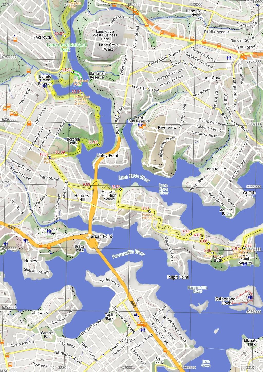
1 Sydney to Thornleigh via Lane Cove Tourist Park 2 Days 33 km One way Hard track m This overnight walk starts from the Obelisk in Macquarie Park, Sydney, at the official start of the Great North Walk. The walk soon boards the ferry from Circular Quay to Woolwich, and follows the Great North Walk through the streets of Hunters Hill and into the Lane Cove National Park. After staying the night in a caravan park here, the walk backtracks a little, then heads north, winding through the Lane Cove Valley, up to Thornleigh train station. Repeated keys in data Lane Maps, text & images are copyright wildwalks.com Thanks to OSM, NASA and others for data used to generate some map layers. Cove National Park
 in 1818.")
2 The Obelisk Before You walk The Obelisk in Macquarie Place (Cnr of Bridge and Loftus Sts) is the original Mile Stone for 19th century roads in NSW. The surrounding park is the original town square built in 181, while the Obelisk was erected by Governor Macquarie (well actually the Convicts did the heavy work) in For nearly 2 years this monument stood as the zero mile/km marker for all principal roads. There are a number of inscriptions including distance markers and "The Obelisk was erected in Macquarie Place A.D.1818, to Record that all the Public Roads Leading to the Interior of the Colony are measured from it. L.Macquarie Esq Governor". The park has a number of other historic items worth exploring. Bushwalking is fun and a wonderful way to enjoy our natural places. Sometimes things go bad, with a bit of planning you can increase your chance of having an ejoyable and safer walk. Before setting off on your walk check 1) Weather Forecast (BOM Metropolitan District) 2) Fire Dangers (Greater Sydney Region, unknown) 3) Park Alerts (Lane Cove National Park, Berowra Valley National Park) 4) Research the walk to check your party has the skills, fitness and equipment required 5) Agree to stay as a group and not leave anyone to walk solo Goat Paddock Goat Paddock is the open area north of Woolwich Dock. The park has a path winding down through the middle, providing access to the waters edge. In 1835, the Clarke family received a grant of the land at the eastern end of the peninsula, what we now call Woolwich. In 1898, Morts Dock and Engineering Company bought this land and commissioned the excavation of the dock. The area is well maintained and is used by many locals for their morning strolls. Woolwich Lookout Woolwich Lookout is a fenced lookout atop of the cliffs at the western end of Woolwich Dock. There are great views down the sandstone cutting, through the dock at the mouth of the Lane Cove River and to North Sydney. In December 191, the W. Solomon & Sons company (commissioned by Morts Dock and Engineering Company) completed the excavation of 85, cubic metres of sandstone to construct this dry dock. At the time, this 188 metres long, and 27 metres wide, pit was the largest dry dock in Australia. In 1963, the Army purchased the site and now it is managed by the Sydney Harbour Federation Trust. Kellys Bush In the late 188s, pocket of bushland between Prince George Parade and Alfred St, Woolwich was set aside to to act as a buffer zone between the Parramatta River and the Sydney Smelting Company. The area was named after the owner of the land and smelting company, T.H. Kelly. From the passion of the local people who fought to protect this area, Kelly's Bush is now owned by the Hunters Hill Council and cared for by a team of local bush regenerators. Think before you TREK The 'Think before you TREK' program developed by NSW Police & NPWS promotes the benefits of planning ahead for your bushwalking trip by using an easy to remember acronym: adequate supplies of food, water, navigation and first T Take aid equipment. your planned route and tell friends and family when R Register you expect to return. beacon (PLB's) should be carried on walks with E Emergency significant gaps in mobile coverage (check terrain profile). to your planned route and follow the map and walking K Keep trails. Topo Maps The maps provided on wildwalks are helpful, but there are times where you may need maps covering a broader area. Maps that cover this walk include; 1:25 Map Series:9134S HORNSBY, 9133N PARRAMATTA RIVER 1:1 Map Series:913 SYDNEY Grade This walk has been graded using the AS The overall grade of the walk is dertermined by the highest classification along the whole track. 4 Grade 4/6 Hard track Length 33 km One way Time 2 Days Quality of track Rough track, where fallen trees and other obstacles are likely (4/6) Signs Directional signs along the way (3/6) Experience Required Some bushwalking experience recommended (3/6) Weather Storms may impact on navigation and safety (3/6) Infrastructure Limited facilities, not all cliffs are fenced (3/6)
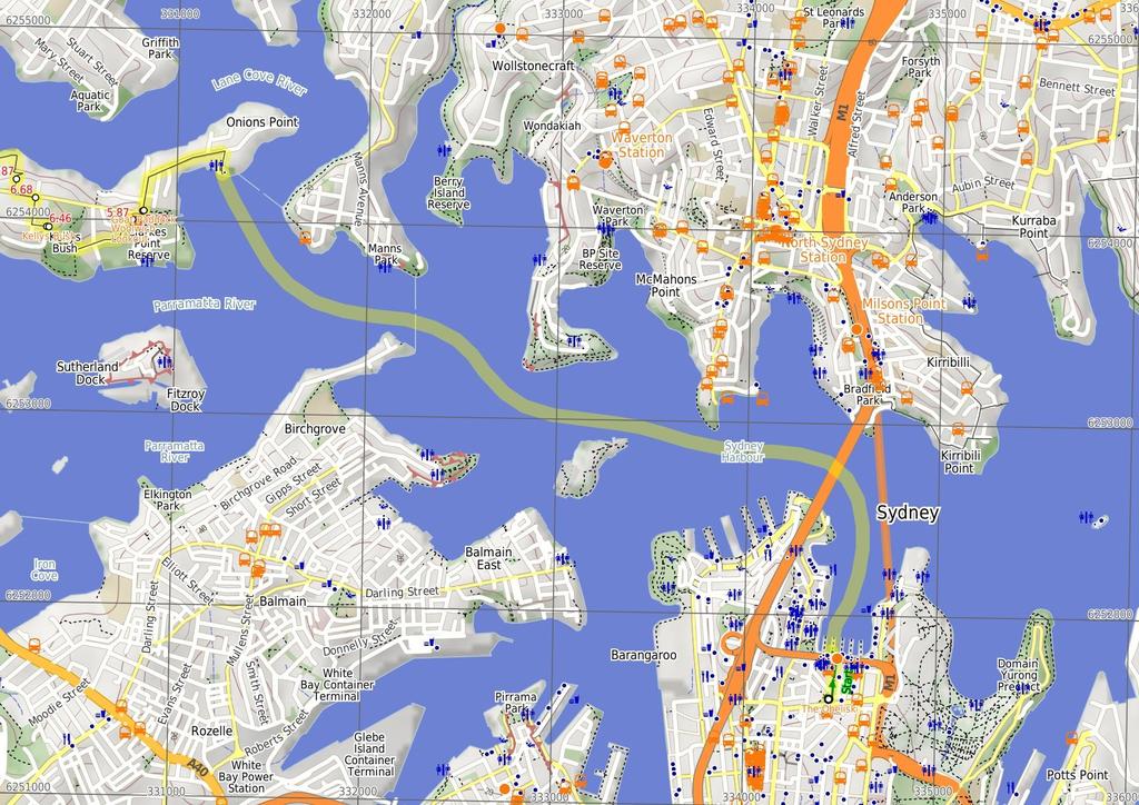
3 Are you ready to have fun? Please ensure you and your group are well prepared and equipped for all possible hazards and delays. Check park closures, weather information and Fire Danger Rating before setting out. Optional side trips and alternate routes noted are not included in this walks overall grade, length or time estimate. Please allow extra time for resting and exploring areas of interest. The authors, staff and owners of wildwalks take care in preparing this information but will not accept responsibility for any inconvenience, loss or injury you may experience. Please take care, have fun - Happy Walking. Getting there You can get to The Obelisk (gps: , ) by car, ferry, train or bus. Car: There is free parking available. You can get back from Thornleigh Train Station (gps: , ) by car, train or bus. Car: There is free parking available. Find up to date and more information inlcuding; travel directions, weather, park closures and walker feedback at The Obelisk The Obelisk in Macquarie Place (Cnr of Bridge and Loftus Sts) is the original Mile Stone for 19th century roads in NSW. The surrounding park is the original town square built in 181, while the Obelisk was erected by Governor Macquarie (well actually the Convicts did the heavy work) in For nearly 2 years this monument stood as the zero mile/km marker for all principal roads. There are a number of inscriptions including distance markers and "The Obelisk was erected in Macquarie Place A.D.1818, to Record that all the Public Roads Leading to the Interior of the Colony are measured from it. L.Macquarie Esq Governor". The park has a number of other historic items worth exploring. The Obelisk (26 m 4 mins) From the tall sandstone obelisk (in Macquarie Place at the intersection of Bridge and Loftus Sts, Sydney), this walk heads down along the footpath beside Loftus St, towards the view of the Harbour Bridge. After about 8m, the footpath leads past 'Jessie Street Gardens', which is 'Dedicated to the achievements of Australian women' - definitely worth the time to read the plaques. From here, the walk continues down past McDonald's and across Alfred St to underneath the 'Circular Quay Railway Station' building..26 Circular Quay (4.8 km 2 mins) Continue straight: From Circular Quay ferry terminal, this walk heads over to Wharf 5 and catches a ferry (about $6) to Woolwich Ferry Wharf, Valentia St. A ferry leaves every 3-6 mins during the day. The trip is very pleasant and passes the Opera House, travels the under the Harbour Bridge, around Garden Island, near Cockatoo Island and on to Woolwich Ferry Wharf near the mouth of the Lane Cove River. 5.7 Woolwich Ferry Wharf, Valentia St (72 m 13 mins) Continue straight: From Woolwich Wharf (at the end of Valentia Street), this walk follows the footpath, past the toilets and the large 'Great North Walk' sign (and past the children's playground which is across the road) to the top of 'Valentia St'. The walk turns left and follows the treelined 'The Point Rd', which bends left and becomes 'Gale St'. Not far along Gale St, this walk comes to the front of the gates at the top of the signposted 'Goat Paddock' park (on your left) 5.8 Goat Paddock Goat Paddock is the open area north of Woolwich Dock. The park has a path winding down through the middle, providing access to the waters edge. In 1835, the Clarke family received a grant of the land at the eastern end of the peninsula, what we now call Woolwich. In 1898, Morts Dock and Engineering Company bought this land and commissioned the excavation of the dock. The area is well maintained and is used by many locals for their morning strolls. the road and heads to the end of Serpentine Rd. There are some GNW arrows here and a footpath on the left. 5.8 Goat Paddock (8 m 1 mins) Continue straight: From the gates at the top of 'Goat Paddock', this walk follows the footpath uphill beside Gale St, which soon bends right. The walk passes 'Woolwich Pier Hotel' (on the opposite side of the road), then veers left across the grass on the signposted 'Woolwich Lookout' park, and soon comes to the fenced lookout platform on the left, about 8m from the lookout End of Serpentine Rd (42 m 1 mins) Continue straight: From the end of Serpentine Rd, this walk follows the GNW arrows down a few steps, then downhill along the footpath. The path soon leads down to Vernon St to turn left, following the street for about 3m. Here the walk turns right, leading down a pedestrian lane-way and steps between two house, coming to 'Mornington Reserve', beside Alexandra Bay on the Lane Cove River. Here the walk turns left, leading up along the grassy track reserve behind some houses for about 18m to turn left at a GNW post marking another pedestrian lane-way. The walk heads up this lane-way then up the steps to turn right on Vernon St, coming almost immediately to an intersection with Brookes St (on your right) Woolwich Lookout Woolwich Lookout is a fenced lookout atop of the cliffs at the western end of Woolwich Dock. There are great views down the sandstone cutting, through the dock at the mouth of the Lane Cove River and to North Sydney. In December 191, the W. Solomon & Sons company (commissioned by Morts Dock and Engineering Company) completed the excavation of 85, cubic metres of sandstone to construct this dry dock. At the time, this 188 metres long, and 27 metres wide, pit was the largest dry dock in Australia. In 1963, the Army purchased the site and now it is managed by the Sydney Harbour Federation Trust Woolwich Lookout (36 m 7 mins) Continue straight: From 'Woolwich Lookout', this walk winds down the concrete footpath, initially keeping the water view to your left. Crossing the road, this walk then follows the GNW arrow post downhill along Edgecliff Rd, which soon bends right (enjoying the water views across to Cockatoo Island), then crosses Margaret St to become Alfred St. Continuing to the end of Alfred St, this walk comes to a short sandstone wall and a 'Kellys Bush' sign 6.23 Bottom of Kellys Bush (23 m 6 mins) Continue straight: From the end of Alfred St, this walk follows the 'Nelson Parade' sign up the sandstone steps. At the top of the steps, this walk turns right, following the 'Picnic Area' sign along the dirt track for about 8m to a three-way intersection just past a bench seat. This walk veers right, following the 'Nelson Parade' sign up the steps, passing a 'Kellys bush' information sign at the top of the hill, then leaves the park through a gap in the timber fence to come to a road beside Weil Park (a large playing field) Kellys Bush In the late 188s, pocket of bushland between Prince George Parade and Alfred St, Woolwich was set aside to to act as a buffer zone between the Parramatta River and the Sydney Smelting Company. The area was named after the owner of the land and smelting company, T.H. Kelly. From the passion of the local people who fought to protect this area, Kelly's Bush is now owned by the Hunters Hill Council and cared for by a team of local bush regenerators Top of Kellys Bush (22 m 4 mins) Continue straight: From the top of Kellys Bush, this walk follows the GNW arrow gently uphill along Prince George Parade (directly away from the park). Soon after passing a set of swings (on the central reservation), this walk turns right (crossing over the other part Prince George Parade) to follow another GNW arrow post along 'Gladstone Ave' until coming to an intersection with 'Woolwich Rd' Int of Gladstone Ave and Woolwich Rd (19 m 3 mins) Turn left: From the intersection, this walk follows the GNW arrow west alongside Woolwich Rd for about 1m, then turns right across 7.29 Int of Brookes and Vernon Sts (1.2 km 22 mins) Continue straight: From the intersection, this walk heads uphill along Vernon St which soon bends left. At the top of the hill, this walk turns right to follow the footpath beside Woolwich Rd for about 15m, then turns right down Futuna Lane. At the T-intersection, this walk turns left to follow Futuna St past the grand 'St. Peter Chanel Catholic Church' building and then come to another T-intersection. Here the walk crosses Crescent St and turns right a short distance and then left into Garrick Ave. At the end of Garrick Ave, this walk follows the GNW arrow along the zigzagging pedestrian lane way for about 17m to come to Passy Ave. Here the walk crosses the road and turns right, following the footpath for about 15m to then turn left onto Ambrose St. After a further 1m, the walk turns right at Ferry St to pass in front of the large sandstone 'All Saints Anglican Church' building. Just past this church, the walk passes a few shops to cross Alexandra St, then turns left. Just after crossing Ady St, this walk comes to to 'Jaspers Restaurant', opposite more cafes and shops. 8.5 Hunters Hill Shops Just opposite the intersection of Alexandra and Ady Streets is a community shopping village in Hunters Hill. There are a few cafes and small restaurants set among a lovely series of sandstone buildings. You could even get your hair cut if so desired. The Ricciotti Deli Cafe open 7 days 8-17 (weekends 8-15) ph: (2) Hunters Hill Shops (77 m 15 mins) Continue straight: From in front of 'Jaspers Restaurant', this walk heads gently downhill along Alexandra St almost immediately passing 'Vienna' Cottage (an artisan's home built in 1871). This walk continues along beside Alexandra St for about 5m, passing the post office, Masonic Centre, town hall, Congregational Church, a tiny and very old-looking pharmacy to come to a four-way intersection with Mount St (on your right), opposite a children's playground. Here the walk follows the GNW post right and downhill along Mount St to come to a waterfront intersection at the end of the street End of Mount St (62 m 11 mins) Turn left : From the northern end of Mount St, this walk follows the asphalt footpath behind Hunters Hill High School, whilst keeping the Lane Cover River to your right. The path leads past a few information signs, then bends left at the grassy clearing to head up the side of the school. The path leads up a small set of stairs and turns right on Reiby Rd, where the walk follows the road for 1m until the road bends right. Here, the walk crosses the road to follow the GNW arrow up to the right and along the concrete footpath, which leads under under Burns Bay Rd (Fig Tree Bridge). Just after passing under the bridge, the walk heads left, diagonally up through Joubert Street Reserve to Joubert St (just downhill from the intersection with
4 Figtree Rd) Joubert Street Reserve (93 m 17 mins) Continue straight: From Joubert Street Reserve, this walk crosses Joubert St and heads uphill to then turn right into Figtree Rd. The walk leads along the footpath beside Figtree Rd for about 35m, then turns right onto Ryde Rd (there is a Coles Express service station to your left, if you want a cold drink). Following the footpath alongside Ryde Rd for about 5m (passing St Joseph's College along the way), this walk comes to Boronia Ave, just beside Boronia Park Boronia Park Boronia Park is found at the intersection of Ryde Rd and Boronia Ave. The park is centered around a couple of large playing fields and a grand stand. Here you will find public toilets, tap water, electric BBQs and a children's playground. There is also shade from the trees and rain shelter to provide some relief on the hot or wet days Boronia Park (27 m 5 mins) Turn right: From the intersection of 'Boronia Ave' and 'Ryde Rd' (beside 'Boronia Park' ), this walk follows 'Boronia Ave' downhill for just over 25m to come to the end of the road End of Boronia Ave (84 m 17 mins) Continue straight: From the end of Boronia Avenue, this walk follows the GNW arrow post up along the rocky track. The track leads over a small rise then bends right (ignoring the track to your left), to head down a few stone steps, then a series of timber steps. The track then continues along the bank of the Lane Cove River (to your right) for about 1m to come to a T-intersection with Princes St. Here the walk turns left and heads up the road (away from the water view) for about 5m, coming to an intersection with another track and a large green 'The Great North Walk' signpost (on your right). Turn right: From the intersection, this walk follows the 'Buffalo Ck. Park' arrow down along track. Veering right after about 5m, this wide track then leads through the casuarina forest for a short time, coming to an intersection and a small clearing with a picnic table, the informally named Brickmakers Creek picnic area. Turn right: From the picnic area, this walk follows the GNW arrow post across the rocky Brickmakers Creek and up the steps. The walk continues along the short timber boardwalk, then leads up the timber steps for about 1m where the track flattens out, veering right at another GNW arrow post. Here the track leads down between the rocks, with a filtered view to the water, and a short distance later, the track veers right again at another GNW arrow post, heading gently down between some more rocks. For another 15m, the mostly flat track leads over some rock platforms then along a short section of timber boarding to come to a three-way intersection marked with a GNW arrow, and a larger unfenced rock platform (to the right) Int of GNW and Meyers Avenue track (1 km 2 mins) Veer right: From the intersection, this walk heads along the rock platform, keeping the river down to your right. The walk soon heads down some steps carved in the rock, then follows the rocky and sandy track gently downhill, passing some interesting rock formations over about 14m then climbing over some rocks with a metal handrail. The track leads up a series of steps for about 2m, then goes up some carved steps (also with a handrail). From here, the rocky track heads down the steps then leads alongside the mangroves for just shy of 1m, coming to a T-intersection marked with a GNW arrow. Turn left: From the intersection, this walk follows the GNW arrow up the steps. The track bends right and comes to an intersection with the signposted 'Access to Barons Cres' track on your left, just below the large concrete building. Continue straight: From the intersection, this walk follows the GNW arrow post along the clear track, leading gently uphill (initially keeping the concrete building and Barton Cres track on your left). The fairly flat, rocky track leads through the forest, keeping the Lane Cove River not far to your right. After about 3m, the track leads up some steps to a boulder outcrop with good views over the river. The track continues for another 1m to a small clearing and a timber viewing platform (on your right) Mangrove viewing platform This timber viewing platform is found on bank on south-west of the confluence of the Lane Cove River and Buffalo Creek. This area is affected by the tides so the view is constantly changing. The lookout platform provides an opportunity to view the mangroves community and the eroded sandstone ruins Mangrove viewing platform (78 m 13 mins) Turn left: From the timber platform, this walk heads directly away from the Lane Cove River and follows the track up the valley, keeping the Buffalo Creek mangroves to your right. The track soon leads under a fallen tree and meanders along the flat for about 12m, then follows a short section of timber boardwalk. The track then leads up some steps to pass under a small sandstone overhang, then continues along the base of a sandstone wall, from where the track leads over another shorter section of timber boardwalk. The track then comes to another section of boardwalk which leads through the wetlands, over a small creek and past the information sign about the 'Friends of Buffalo Creek'. The boardwalk then leads past some paperbark trees and turns right onto the dirt track. The walk follows this track for about 5m before heading up the timber ramp and steps to Pains Rd. Turn right: From the intersection, this walk follows GNW arrow up along Pains Rd for about 2m to the intersection with a wide track, marked with another GNW arrow post, just where the road bends left. Continue straight: From the bend in Pains Rd (near house number 4), this walk follows GNW arrow along the wide track, whilst keeping a few houses up to your left. After about 12m, the track leads up a grassy hill to find a large open parkland, Buffalo Creek Reserve. Here, the walk turns right and follows the 'Great North Walk' sign across the grass, passing a picnic table and fireplace, and coming to the large 'Buffalo Creek Track Head' signpost (on your right) Buffalo creek track head (54 m 13 mins) Turn right: From the 'Buffalo Creek Track Head', this walk follows the 'Newcastle' sign down three sets of timber stairs. Here the walk follows the timber boardwalk as it winds through the mangroves to a handrailed viewing area, just before a bridge. From here, the walk crosses Buffalo Creek on the bridge then climbs up the stone steps to veer left at a faint intersection (at the top of the steep climb), marked with a GNW arrow post. The rocky track leads more gently up past the 'Lane Cove River National Park - Sugarloaf Point' sign to a signposted T-intersection, where another GNW arrow points back down the track. Turn right: From the intersection, this walk follows the 'Sugarloaf Point' sign along the flat rocky and sandy track, keeping the valley to your right. The track generally bends left around the side of the hill, passing a few interesting rock platforms along the way. Soon after heading down some stone steps, this track comes to a signposted T-intersection with a wide sandy trail. There is a 'Buffalo Ck Reserve' sign pointing back up the steps Optional sidetrip to Sugarloaf Point (28 m 5 mins) Turn right: From the intersection, this walk follows the 'Sugarloaf Point' sign down the hill and along the service trail to the open waterfront clearing at Sugarloaf Point, which extends all the way along to the end of the grass clearing. At the end of this side trip, retrace your steps back to the main walk then Continue straight Sugarloaf Point Sugarloaf Point is a large grassy clearing with a picnic area on the edge of the Lane Cove River, just north of the Buffalo Creek junction. The riverside picnic area has a couple of picnic benches and a small beach, making it possible to pull a boat up to the point Int of GNW and Sugarloaf Point tracks (78 m 14 mins) Turn left: From the intersection, this walk follows the 'Pittwater Road.25km' sign up along the wide management trail, which soon becomes sealed. The trail winds up beside a large, fenced, high-tension power line concrete tower. The trail soon leads around a locked gate and comes to an intersection just before Pittwater Rd, with a 'Great North Walk' track sign (on the right). Turn right: From the intersection, this walk follows the 'Great North Walk' sign past the picnic table and down the timber steps, whilst keeping Pittwater Rd through the trees to your left. The track soon passes a 'Lane Cove National Park' sign then heads down some timber stairs. The track continues just below the road (on your left) and beside the mangroves (on your right) for a little over 4m, crossing several timber platforms and going up and down a few steps to come to a 'Coastal Wetlands' information sign. Having moved away from the road, the track now heads along a timber boardwalk that winds through the mangroves and wetlands to cross Kitty Creek on a bridge. Just on the other side of the bridge, this walk comes to a Tintersection with a sign pointing back to 'Sugarloaf Point' Kittys Creek bridge int (72 m 14 mins) Turn right: From the intersection, this walk follows the GNW arrow along the wide track, initially keeping Kittys Creek to your right. The track almost immediately bends left (ignoring the side track on the left) and follows the bank of the Lane Cove River (on your right) through the casuarina forest for just shy of 2m. Here, the track starts edging away from the river and enters more dense vegetation for just over 2m, before the track opens up and comes to a 'Lane Cove National Park - Sugarloaf Point' sign. From the sign, the walk leads up along the grass, keeping the playing fields to your right and coming to a GNW arrow post in front of the toilet block beside Magdala Park car park Magdala Park Magdala Park, found at the end of Magdala Rd, North Ryde, is home to a large playing field with a baseball diamond in the corner and a smaller playing field to the north. There is a car park, public toilets, sheltered picnic tables, childrens playground, garbage bins, and town water on tap. There are a few Great North Walk signs highlighting the direction of the walk as it winds across the open grassy area Magdala Park carpark (11 m 2 mins) Turn right: From the front of the toilet block, this walk follows the GNW arrow across the car park. The walk then heads through the gap in the fence and turns left, heading over the grass to the intersection with a concrete footpath at the base of the large transmissions tower, where a sign points back to 'Sydney Cove' Magdala Park transmissions tower (1.4 km 31 mins) Turn right: From the transmissions tower, this walk follows the 'Newcastle' sign downhill along the concrete footpath away from Magdala Park. The path soon turns right and leads over the 'Clifford Love'
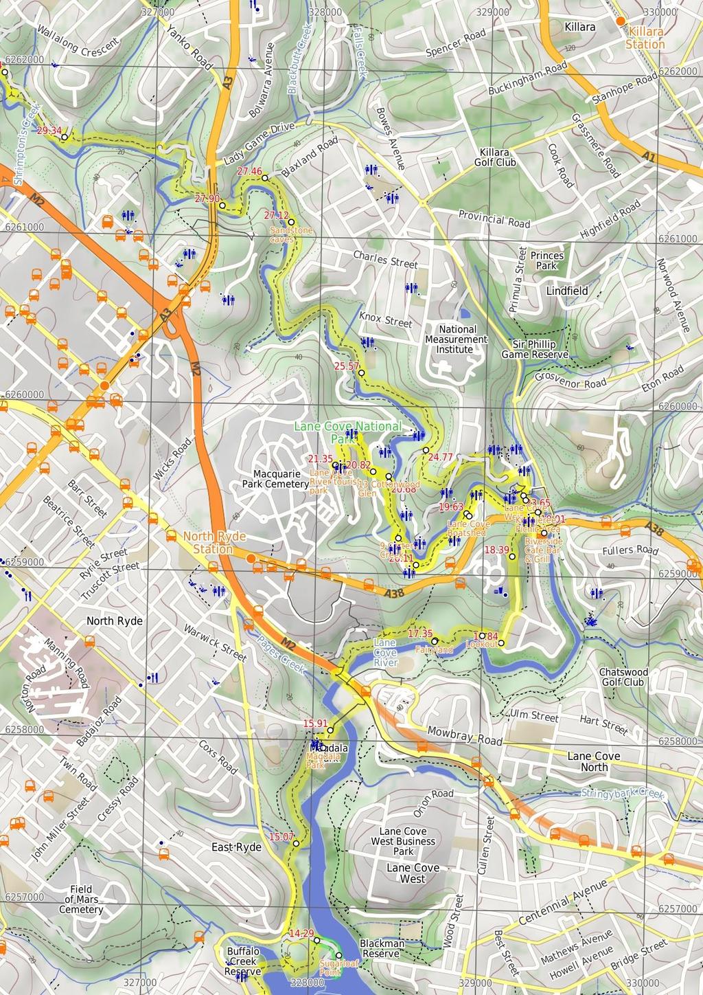
5 footbridge. The 15m-long bridge leads over Lane Cove River and then over the 'National Starch' factory, to find a footpath on the other side. The footpath leads around the edge of the fenced car park and comes to the footpath beside Epping Rd, just beside the traffic lights at Mowbray Rd. Continue straight: From the traffic lights, this walk heads downhill towards the bridge, crossing the factory driveway. Just over 1m past the driveway, the shared footpath leads to an intersection marked with a GNW arrow post, and a set of steps (on the left). Continue straight: From the intersection, this walk follows the GNW arrow post down across the main bridge span, keeping the traffic to your right. After almost 1m, this walk comes to the other side of the bridge, where there is an intersection with another set of stairs (on your left) and another GNW arrow. Turn left: From the intersection, this walk follows the GNW arrow post down the stairs and towards the water. At the bottom of the stairs, the walk turns left and follows the footpath under the bridge then up a few steps to a signposted intersection, just on the other side of the bridge. Veer right: From the intersection, this walk follows the 'Lane Cove National Park - Fairyland Track' sign down along the dirt track, keeping the filtered view of Lane Cove River to your right. The track soon leads down some timber steps, past a short rock wall and across two short flat timber bridges. The walk continues up some steps and across a timber bridge with a hand rail. The rocky track then leads downhill for about 1m before going gently uphill past the high tension transmission tower, to then come to a signposted intersection, just after passing under the power lines. Continue straight: From the intersection, this walk heads away from the buildings and the high tension power line tower, following the GNW arrow post downhill and almost immediately crosses a small flat timber bridge. The rocky track leads up a short hill then the track starts to leads down for about 7m, where the track bends sharply right. Then the walk leads down a series of timber steps into the lusher forest and a 'Site of Fairyland Pleasure Grounds' information sign. Here the walk heads along the timber boardwalk, then follows the track past the 'Take Yourself Back to Fairyland' photo sign, and then onto an intersection beside a large palm tree. There is a 'Fairyland Pleasure Grounds' sign and short track on the right that leads to a seat beside Lane Cove River Fairyland Once formally known as 'Fairyland Pleasure Grounds', and casually as 'The Rest', this site was similar to several others in Sydney. The land was purchased by Robert Swan in 1896 and encompassed about 17 acres in total. Part of the land was cleared for a market garden, growing strawberries and melons. By the early 19s, the market garden had closed and the area had become a popular picnic and play ground, for people arriving mostly by boat. This was a very popular spot to visit for a special day out. Today, the buildings have (mostly) gone and the cleared area has grown back, but it still can offer a relaxing picnic and lunch spot by the river Fairyland (36 m 7 mins) Continue straight: From the intersection at the centre of Fairylands, this walk follows the clear track whilst keeping the Lane Cove River through the trees to your right, past the 'Fairyland Pleasure Grounds' sign. The mostly flat track winds gently through the ferns to pass the 'Site of Fairyland Pleasure Grounds' information sign, then continues along the short timber boardwalk and up a series of timber steps. The now mostly-flat track leads along the side of the hill for about 15m, coming to a short track which takes this walk to an unfenced rock platform with river views (on your right) Lookout This small, informal and unfenced viewpoint is atop a large natural rock platform, between Fairyland and River Ave. There are a few in the area, but this is the most distinct. From here, there are nice views down the Lane Cove River. The area is unfenced and there is a significant drop off the side River view (13 m 3 mins) Continue straight: From the view point, this walk heads along the flat track whilst keeping the river below to your right. After about 1m, the track crosses a short section of timber boardwalk then leads past a series of National Park signs to come to a T-intersection with Quebec Rd (opposite number 11) Int. of Quebec Rd and Fairyland Track (55 m 12 mins) Turn left: From the intersection, this walk heads uphill following the GNW arrow post along Quebec Rd. At the top of the hill, the road bends right and comes to a signposted intersection, where this walk turn left to follow the GNW arrow post up what looks like a long sealed driveway. The walk follows Quebec Ave for about 3m past a couple of driveways (on your right) then below the fenced Northern Suburbs Memorial Gardens (on your left), coming to a turning circle and a locked gate at the end of the road End of Quebec Ave (4 m 8 mins) Continue straight: From the end of Quebec Ave, this walk follows the GNW arrow post around the locked gate and along the fairly flat, rocky track. After about 17m, this track leads to the edge of a large rock platform. From here, the walk tends right, going down through a gap in the rock then leading along the base of a short rock wall. The track then starts to lead more steeply downhill when, just after passing a small bench seat, the track leads down a steep stone staircase and then comes to a signposted Tintersection with River Rd (near Delhi Rd). Here, a 'Sydney Cove' sign points back up the hill. Continue straight: From the intersection, follows the GNW arrow post across River Ave, down along the minor road (keeping the busy Delhi Rd to your left). At the end of this minor rd this walk finds a footpath in front of 'Riverside Cafe Bar & Grill' Riverside Cafe Bar & Grill The Riverside Cafe is found at the end of service road on the south-west corner of Fullers Bridge. The nicely renovated building looks over the Lane Cove River and is open 7 days, serving breakfast, lunch and dinner. The food is cafe-style and meals are priced upwards from $13. Ph: (2) Riverside Cafe (23 m 4 mins) Turn left: From in front of 'Riverside Cafe Bar AND Grill', this walk follows the GNW arrow post and footpath under Fullers Bridge to an intersection with a set of steps just on the other side. Turn left: From the intersection (on the north-west corner of Fullers Bridge), this walk heads up the steps to come to another footpath beside Dehli Rd. Turn right: From the bus stop, this walk heads along the footpath, away from Fullers Bridge. The walk soon crosses the entrance road to Lane Cove National Park before winding right, through the low bushes, to come to the toilet block. Turn right: From the toilet blocks, this walk heads across the road to follow the footpath through the middle of the Koonjeree picnic area, to the intersection near the water's edge Koonjeree Picnic Area Koonjeree Picnic Area is at the southern end of Lane Cove National Park, just near Fullers Bridge. The picnic area boasts free gas barbecues, flushing toilets, town tap water, picnic tables and shelters, a large open area and car parking. On the bank of the Lane Cove River, this is a pleasant spot to enjoy the park Koonjeree Middle Trk (1 m 2 mins) Turn left: From the intersection, this walk follows the GNW arrow post along the concrete footpath, keeping the river just to your right. The path leads around the edge of the clearing and comes to a T-intersection with a road, just beside the weir (on your right) Lane Cove Weir South (52 m 9 mins) Turn left : From the southern end of the weir, this walk follows the sealed road up (away from the weir) for about 1m to turn right following the 'Riverside walking track' sign along the fenced timber boardwalk. After about 5m, this boardwalk leads past the fish ladder to come to a lookout (with stepped seats) and great views over the Lane Cove River. From the lookout, this walk continues along the boardwalk for about 8m (enjoying more river views) to then follow another 'Riverside walking track' sign along the edge of '3 Spoonbill' picnic area for about 13m, and come to '4 Illoura' picnic area (with toilets and water). This walk continues along the track beside the river for another 12m to pass below a large picnic shelter, then just over 1m later, this walk comes to the shop-front side of the sandstone boatshed building Lane Cove Boatshed Lane Cove Boatshed, in Lane Cove National Park, is situated on the bank of the (you guessed it) Lane Cove River. You can hire rowboats, kayaks, pedal boats, bikes and canoes, for different ways to enjoy the river. The shop also sells ice-creams, chips and drinks. The shed is open on weekend from 1am 5pm. During summer school holidays, the shop is also open from 12-5pm. For more info, call Greg on Boat Shed (47 m 9 mins) Continue straight: From the shop-front side of the boatshed, this walk follows the riverside track upstream, keeping the river just to your right. The track soon narrows and after about 8m, comes to a large clearing, the '7 Moola' picnic area (with toilets and water). The track leads over a small flat timber bridge in the middle of the picnic area to then find a NPWS arrow post on the far side. Here this walk follows the arrow along the track for about 7m to then climb up the metal staircase, where the track continues for another 18m, first up and over a rocky outcrop then along a flat track to find another large clearing. On the far side of this picnic area, just past the '8 Ironbarks' sign, this walk comes to a three-way intersection (with a concrete path on your left) Ironbarks (22 m 4 mins) Continue straight: From the intersection, this walk follows the NPWS arrow post along the narrow management trail, keeping the river to your right. After about 6m, this walk heads around a locked gate, then heads up over the grass to find a picnic area. Here the walk heads over the timber bridge, past the '9 Carters Creek' sign and into the picnic area. The walk veers left across the picnic area to come back to the car park, just below the toilet block on the far side of the picnic area Carters Creek Carters Creek Picnic Area is the ninth formal picnic space along this stretch of the Lane Cove River. This picnic area is home to a couple of sheltered picnic tables, a gas BBQ a large open grassy area, garbage bins, toilets and a car park. There is some limited access to the river view. A pleasant spot among the tall gums Carters Creek (36 m 6 mins) Continue straight: From the picnic area, this walk follows the NPWS arrow post across a small creek and up the footpath, away from the picnic area. From the the top of the small hill, the track now leads (keeping the river on your right) for almost 3m, passing through a re-vegetating tall
6 gum forest then a pleasant she-oak stand, to come to a large gravel car park just before Cottonwood Glen picnic area Cottonwood Glen Cottonwood Glen picnic area is a large open grassy spot on the bank of the Lane Cove River. There is a grove of trees along the edge of the river, but you can still get clear views across the water from the car park area. There are several picnic tables and a small toilet block just up the hill Cottonwood Glen (13 m 3 mins) Turn left: From car park beside '13 Cottonwood Glen' picnic area, this walk follows the 'Lane Cove Tourist Park' arrow post up the road. This walk soon veers left to head up beside the '12 Blackbutt' picnic area, then up some steps to come to a signposted intersection with Riverside Drive Riverside Dr (54 m 11 mins) Continue straight: From the intersection, this walk follows the 'Tourist Park' sign gently up the track (away from the road) for about 3m to pass a 'Native Fauna' information sign and cross a small metal bridge beside the tall fern trees. Here the walk continues gently up through the forest for another 3m to pass the 'Bush Regeneration' information sign, then the track continues to wind gently uphill for almost 18m, passing the 'Native Flora' information sign and coming to a three-way intersection beside a large gum, where a sign points back down to 'Lane Cove River Weir' sign. Turn left: From the intersection, the walk heads uphill directly away from the face of the 'Scribbly Gums picnic area' sign and past the large scribbly gum. The track leads under a banksia tree and after about 4m starts to climb a series of stone steps. After climbing these steps for about 6m, this walk heads through a gap in a fence to come to the edge of the Lane Cove Tourist Park. From here, this walk head directly away from the face of the 'Lane Cove National Park' sign and straight up the internal road. This road soon bends left then leads though the campsite for about 1m before bending right just past the laundry. Here the walk heads up this road for about 5m, past the boom gates, to come to the front of the the 'Lane Cove Tourist Park' office Lane Cove River tourist park This is a well-established caravan park on the edge of Lane Cove National Park, offering a variety of camp sites from tent to powered sites for caravans and even en suite cabins. The campsite is a great point to access many wonderful walks in Lane Cove Valley. There are many facilities including a laundry, toilets, showers (including facilities for people with disabilities and with infants), recreation room, Internet kiosk (with free access to Wildwalks.com), wireless Internet, BBQ's and a pool. There is bike hire available and the reception has basic supplies for sale (bread, milk, snacks, newspapers) End of day 1 This is the planned overnight stay for the end of day 1, happy camping.
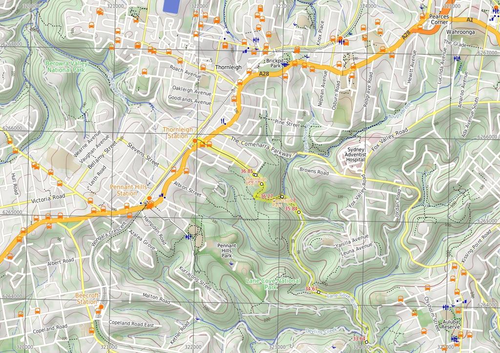
7 21.35 Lane Cove Tourist Park (2.2 km 42 mins) Turn around: From the office of the 'Lane Cove Tourist Park', this walk heads down the internal road, past the boom gates for about 5m to turn left just past the laundry. The walk then continues along this road as it bends right after about 1m, then leads down to a T-intersection. Just on the other side (and to the left) of this intersection, there is a set of steps beside the large 'Lane Cove National Park' sign. From this concreted section between sites 152 and 151, this walk follows the sign down the stone steps for about 6m, where the track then leads gently down to a T-intersection marked with a timber signpost (beside a large scribbly gum). Turn right: From the intersection, the walk follows 'Lane Cove River Weir' sign south down the hill. The track leads gently down the side of the hill for about 8m to pass a 'Native Flora' information sign, then about 9m later passes a 'Bush Regeneration' information sign among the ferns. Just 3m past this sign, the track leads over a small metal bridge beside the tall fern trees and 'Native Fauna' information sign. Here the track continues for a short distance to come to an intersection with Riverside Drive, where a 'Tourist Park' sign points back up the hill. Continue straight: From the intersection, this walk follows the 'Riverside walk' arrow post down the steps and then follows the road down past the '12 Blackbutt' picnic area. Soon the road leads to a Y-intersection and veers right down to the car park beside '13 Cottonwood Glen' picnic area and the Lane Cove River. Turn right: From the car park on the south side of 'Cottonwood Glen', this walk follows the NPWS arrow post along the track into the bush, keeping the river to your left. The track leads along side the river for about 3m, first through a lovely she-oak stand, then through a re-vegetating tall gum forest before heading down a sealed footpath to come to a car park (beside the toilet block) at Carters Creek picnic area. Continue straight: From in front of the toilets at Carters Creek picnic area, this walk heads across the grass clearing and across the small timber bridge to come to the car park. After crossing the car park, this walk continues over the grass, beside the road, keeping the river to your left, and then veers left and follows the NPWS arrow post down around the locked gate. Here the walk follows the narrow trail for about 6m to come to an intersection with a footpath on your right, just before the '8 Ironbarks' sign and picnic area. Continue straight: From the intersection just west of '8 Ironbarks', this walk follows the track through the picnic area, keeping the river on the left. On the far side of the picnic area, this walk follows the NPWS arrow post for about 18m up over a rocky outcrop to then head down a metal staircase. The track winds down alongside the river for another 7m to come to the edge of another large grassy clearing. Here, this walk heads across '7 Moola' picnic area (with toilets and water), crossing a small flat timber bridge in the middle. The track soon leaves this clearing and continues for another 8m to come to the shop-front side of the sandstone boatshed building. Continue straight: From the shop-front side of the boat shed, this walk follows the riverside track, keeping the river to your left. After about 4m, this walk veers left at the Y-intersection and continues alongside the river for another 9m to pass below a large picnic shelter. The walk continues along the track for another 12m to pass alongside '4 Illoura' picnic area (with toilets and water). The walk continues alongside the river for another 7m to then pass through '3 Spoonbill' picnic area. From the far side of this picnic area, the walk follows the path, and then fenced boardwalk, for about 8m to come to a lookout (with stepped seats) and great views over the Lane Cove River. From this lookout point, this walk continues up along the boardwalk for about 5m (passing the fish ladder) to turn left onto the sealed drive and come to another intersection just before the weir Lane Cove Weir South (5 m 1 mins) Continue straight: From the intersection, this walk follows the GNW arrow post across the top of the weir to another GNW arrow post at the top of the steps (on your right), just on the other side of the weir. After heavy or prolonged rain this crossing may be closed if water is flowing over the top. and crosses the 'weedy' creek on a short timber boardwalk. The now flat track leads for another 5m to a signposted intersection (with some steps on your right), where a 'Visitor Centre Loop' sign points back along the track Lane Cove Weir The Lane Cove River Weir was built in 1938 during the depression. The motivation for building the lake was to make the area more apealing for visitors' picnics. The weir created environmental issues such as silting and a decline in native fish populations. In much more recent years, a 'fish ladder' has been construcuted to allow fish to undertake their natural migration route for breeding. The weir proved an easy way for walkers to cross the Lane Cove River whilst enjoying the views up and downstream Fiddens Wharf Oval Trk (1.6 km 32 mins) Continue straight: From the intersection, this walk follows the 'Blue Hole' sign across the flat timber boardwalk bridge, keeping the river to your left. After about 6m, the track passes a small sandstone overhang then crosses a section of timber boardwalk, heading over the rock to a small beach beside the Lane Cove River. The track then continues along the river bank for about 12m to then turn right up a side gully, crossing the creek on a timber footbridge. The track then leads up a short but steep set of timber steps, where the track flattens out to come to a signposted intersection. Here the walk continues straight, following the 'Blue Hole' sign over the small rise then back down to the bank of the river. The rocky track follows the bank for about 25m, where the track climbs the hill for a short time to follow the side of the hill around through the eucalypt and grass tree forest. After about 23m, the track passes along the top of an unfenced cliff (to your left). The track continues for just shy of 4m, passing a series of rock walls. At the end of the clearest (and longest) rock wall, the track turns sharply right and comes to the top of this rock wall. From here, the walk turns left to lead over a rise, then crosses a small flat timber bridge. The rocky track then continues to climb for 1m to come to an unfenced rock platform. Turning right here, this walk climbs up a little further to pass through a sandstone overhang, coming immediately to a second overhang which provides a bit more shelter Lane Cove Weir North (1.1 km 25 mins) Continue straight: From the weir, this walk follows the footpath straight up the hill for approximately 2m to the large concrete area of the intersection. Turn right: From the intersection, this walk heads along the footpath to the road. Veer left: From the intersection, this walk follows the road uphill, keeping the short sandstone wall and National Parks office on your left. The road soon bends left and leads up past the staff parking, to an intersection (with a track on your right) marked with a large 'Great North Walk' sign. Veer right: From the intersection, this walk follows the GNW arrow post up the timber steps away from the road. The track passes a 'Caution - Swimming in Lane Cover River is not advisable...' sign and then comes to an intersection with a wider management trail. Veer left: From the intersection, this walk follows the wide trail uphill, initially keeping the cliff line to your right. The trail bends right then leads uphill for about 13m, coming to an intersection (just below the power lines) where a 'Park Visitors Centre' sign points back down the hill. Turn left: From the intersection, this walk follow the 'Blue Hole - Fiddens Wharf' sign and power line up along the wide management trail. Just as the trail flattens out, this walk comes to an signposted intersection with a narrower track (on your left). Veer left: From the intersection, this walk follows the GNW arrow posts down the timber steps. The track gently meanders through the open forest for a short time then heads up a few steps to come to a T-intersection with a sealed road. Veer left: From the intersection, this walk follows the GNW arrow down along the road for a short distance and comes to another signposted intersection with a track (on your right). Turn right: From the intersection, this walk follows the NPWS arrow up the timber steps, away from the road. The track soon leads down a longer set of timber steps where the track meanders through the bush, passing a few rocky outcrops before heading down the another series of timber stairs. Just beyond these steps, the track leads to a T-intersection with a wide management trail, marked with a 'Sandstone Hillslope Community' information sign Int. GNW and Thistlethwaytes Picnic Area Trk (8 m 16 mins) Turn right: From the intersection, this walk follows the upper arrow on the historic walk sign post, gently uphill along the wide trail. The trail leads through the casuarina forest for about 3m then passes the 'Scribbly Gum' information sign. The trail then bends left and leads downhill, narrowing significantly. Here the track heads down a series of timber steps to pass a 'Sydney Red Gum' information sign. The track then crosses the ferny gully and passes the 'Sandstone Gully Community' and then the 'Sydney Peppermint' information signs. From here, the track leads across another gully then up and along the side of a steep hill (with an unfenced cliff to your left) for about 7m, coming to a rock platform with a 'Blackbutts' information sign. Here the walk leads down the staircase and stone path for a short time Sandstone caves This fairly large sandstone overhang is found on the eastern side of the Lane Cove Valley. The walking track leads through the two caves that run in series, with the northern cave being larger. The lip of the overhang hangs down a bit, providing some extra protection from wind and rain. The cave also provide some shade and a cooler spot on hot days, and there are also a couple of well placed boulders forming nice seats Sandstone caves (34 m 1 mins) Continue straight: From the cave, this walk follows the track along the side of the hill, keeping the valley down to your left. The track soon follows along the base of long sandstone wall (on your right) for about 13m and passes around the right-hand side of a large cube boulder (know as 'The Block'). The track leads across a mossy and rocky gully then uphill to pass through a long tunnel-like sandstone overhang, and along the base of another long sandstone wall. At the end of this wall, the track leads up some rocky steps and then leads gently through the open forest for about 5m before passing under some power lines. The track soon leads up some steps, coming to a signposted T-intersection with a management trail, where a GNW arrow points back along the track Int. GNW and Blaxland Rd Service Trail (44 m 8 mins) Veer left: From the intersection, the walk follows the 'Great North Walk - Deburghs Bridge' sign downhill along the wide management trail. The trail soon bends right and follows the power lines down, stepping over a partially buried, green metal pipeline (sometimes hissing). After this, the trail follows a GNW arrow left as the trail significantly narrows and leads down a series of timbers steps then across the rocky Blackbutt Creek. Here, the walk follows the GNW arrow up onto the rock platform, where the track turns left then leads along the flat to a T-intersection with a GNW arrow post, and a set of steps (up to your right AND down to your left). Turn right: From the intersection, the walk follows the GNW arrow post up the timber steps. The track then leads up some stone steps and comes to a three-way intersection, where a sign points back to 'Lane Cove River Weir via Great North Walk'.
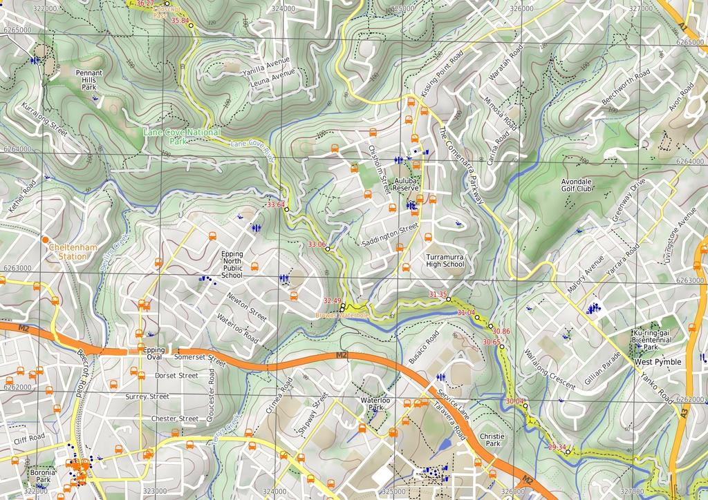
8 27.9 Int GNW and Ryde Rd Access Trk NE (1.4 km 29 mins) Continue straight: From the intersection, this walk follows the 'Thornleigh via Great North Walk' sign down a couple of steps and along the track towards Deburghs Bridge, keeping the valley to your left. After about 5m, the track leads under the large concrete Deburghs Bridge, with some graffiti. On the other side of the bridge, the track bends right to head up over some rocks, following two sections of hand railing. From the end of these handrails, the track leads gently up among the grass trees for about 4m (and a weedy section of track) to come to a clear T-intersection with a management trail, where a 'Great North Walk' sign points back down the track. Continue straight: From the intersection, this walk follows the 'The Great North Walk' sign north, gently downhill along the management trail. After about 8m, this trail crosses a concrete bridge over Rudder Creek (beside a concrete sewerage pipe). From here, the trail leads uphill for just shy of 2m to come to an intersection with the GNW track (on your left), where a 'Lane Cove Weir' sign points back down along the trail. Turn left: From the intersection, this walk follows the 'Thornleigh Oval' sign west, gently down the track, away from the management trail. The track almost immediately passes the large metal pipe (crossing the Lane Cove River) then winds down the rocky track for about 2m, through open eucalypt forest with some limited views left over the valley, to come to a weedy section of track marked with a concrete sewerage access point. Here the track mostly flattens out and leads along the side of the hill for about 4m to head down a few steps and cross Quarry Creek. The walk then heads up some steps and follows the track for another 3m to come to a T-intersection with the Gloucester Ave fire trail, marked with a GNW and NPWS arrow post Int of GNW and Gloucester Ave fire trail (east) (3 m 1 mins) Turn left: From the intersection, the walk follows the GNW arrow post gently uphill along the management trail, away from the gate whilst keeping the power line poles on your left. After about 3m (just past the second power pole), this trail leads to an intersection with a track (on the left), marked with another set of NPWS & GNW arrow posts (just under the high tension power lines) Int of GNW and Gloucester Ave service trail (sth) (69 m 15 mins) Turn left: From the intersection, this walk follows the GNW arrow post south, downhill along the track and under the high tension power lines. The track winds gently downhill for almost 15m until, just after passing close to the the high tension power line tower, this walk comes to a locked green shed opposite a fenced-off pipe bridge (down in the valley to your left). Continue straight: From the green shed, this walk follows the track along the side of the hill, keeping the valley to your left (running parallel with the high tension power lines, up to your right). After about 15m, this walk comes to an intersection with a faint track on your right (that leads a short distance to a management trail), marked with a GNW arrow post. Continue straight: From the intersection, this walk follows the GNW arrow post along the mostly flat track, through the dense forest, and almost immediately passes a concrete sewerage access point. After about 7m, this walk heads down a few timbers steps to cross a small gully, where the track continues for another 1m (passing close to a few houses), then crosses two flat timber bridges over Congham Creek. Here the walk veers left up onto the rock platform and follows the track gently uphill for another 8m to come to a three-way intersection, marked with a GNW arrow post (and a sign pointing left to 'Marsfield'). Veer right: From the intersection, the walk follows the GNW arrow post north, uphill for about 3m to come to a faint intersection with a track (on your right) marked with a GNW arrow post. Veer left: From the intersection, this walk follows the GNW arrow post gently uphill along the side of the hill (keeping the valley to your left) for about 1m to come to a small clearing and three way intersection, marked with yet another GNW arrow post and a pile of rocks (on your left). 3.4 Int of the GNW and mid Gloucester Ave fire trail a (62 m 14 mins) Turn left : From the intersection, this walk follows the GNW arrow post up the short rocky hill and away from the high tension power lines. The track (rocky early on) leads along the side of the hill among some grass trees for about 3m before passing under the power lines again. Here the track continues for another 3m along the side of the valley to come to a clear intersection with intersection with a wide management trail. (on your left, that leads to an informal unfenced lookout), just before a GNW arrow post. Continue straight: From the intersection, the walk heads fairly steeply downhill along the concrete path. The path passes a few signs over about 1m, then comes to an intersection with a track (on your left), marked with a timber barricade and a GNW arrow post. Veer right: From the intersection, this follows the concrete path downhill for just shy of 5m to come to a intersection with a dirt management trail. This intersection is beside the Lane Cove River crossing (on your left) and is marked with a 'The Great North Walk' sign here Int of the GNW and the West Pymble service trail l (21 m 4 mins) Continue straight: From the intersection, this walk follows the GNW arrow post downhill along the management trail. The trail leads down for about 7m to cross a small gully then runs closely beside the Lane Cove River (on your left) for another 12m to come to an intersection marked with a GNW arrow post and a 'Lane Cove Valley' aluminum sign and map Browns Waterhole Browns Waterhole is a wide, shallow section of the Lane Cove River, downstream of a concrete weir. There is a concrete shared cycle/footpath crossing over the top of the weir, linking Kissing Point Road, South Turramurra to Vimiera Rd, Macquarie Park. On the western side of the waterhole, there is a picnic table and small clearing with a view over this section of the river Int of the GNW and the Avondale creek service trai (18 m 4 mins) Turn left : From the intersection, this walk follows the GNW arrow post, directly away from the face of the 'Lane Cove Valley' aluminum sign and map, down the track and timber steps to a sandy beach on the Lane Cove River. Here the walk turns right to cross the weir and bridge over Avondale Creek, (this may become impassable after heavy or prolonged rain) then climb gently uphill for about 12m to come to a faint intersection with a faint track (on your left - this faint track leads down to another old weir). Continue straight: From the intersection, this walk heads gently uphill following the main track, whilst keeping the valley to your left for about 3m to come to a clear Y-intersection marked with a GNW arrow post Browns Waterhole int (57 m 12 mins) Veer right: From the intersection, this walk follows the 'The Great North Walk' sign along the dirt management trail, keeping the Lane Cove River to your left. After about 8m, the trail leads under some high tension power lines, where there is a mostly clear view over the river (to your left). The trail then gently leads down through the valley for about 4m to come to an intersection with Cove St trail, marked with a GNW arrow post. Veer left: From the intersection, this walk follows the GNW arrow post downhill along the management trail for about 3m to cross a small culverted creek. The walk then follows the trail up the short hill to come to an intersection with the signposted 'STEP track' (on your right) Int of GNW and the Turramurra High School bushtrac (31 m 9 mins) Veer left: From the intersection, this walk follows the GNW arrow post along the track, keeping the Lane Cove River a short distance to your left. After about 8m, the track steps up to and crosses a short section to timber boardwalk/bridge. Here the walk climbs up the rocky hill following a series of concrete access points and timber steps for about 23m to come to a T-intersection with a management trail, marked with a GNW arrow post Int of GNW and the STEP track (east) (58 m 1 mins) Continue straight: From the intersection, this walk follows the GNW arrow post and STEP Track markers along the management trail, whilst keeping the river to your left. The trail undulates through the valley (weedy in places) and tall forest for just shy of 6m, to come to a clear intersection at the bottom of a sealed management trail (on your right). This intersection is marked with another 'STEP Track' map/sign and a 'The Great North Walk' sign Int of the GNW and the Turramurra High School serv (1.1 km 23 mins) Veer left: From the intersection, this walk follows the GNW arrow post gently downhill along the management trail for about 4m to come to an intersection with a short trail (on the right, which leads to the gate at the end of Koombalah Ave). Continue straight: From the intersection just below the Koombalah Ave gate, this walk follows the management trail gently downhill, whilst keeping the valley to your left. The trail initially leads over a rock platform, then about 5m later, leads down a steep hill. The trail then heads gently down for about 4m before a short steep hill leads down to a metal high tension power line tower. Here the trail bends right and leads down and along the side of the hill for another 2m to pass another high tension power line tower and head behind a few houses. Just behind the second house, this walk comes to ephemeral creek on a rock platform. Continue straight: From here, this walk crosses the ephemeral creek (keeping the houses up to your right) and continues along the trail for about 3m to come to a T-intersection with a wide, shared, concrete path, marked with several signposts. Turn left: From the intersection, this walk follows the GNW arrow post downhill along the wide, shared, concrete path. After about 5m, this path leads under some high tension power lines then bends right. About 5m after passing under the power lines, this path leads to an intersection with a track Int of GNW and the STEP track (west) (1 km 18 mins) Veer left: From the intersection, the walk follows the 'The Great North Walk' sign gently downhill along the management trail, directly away from the face of the 'STEP Track' map/sign. Keeping the river to your left, the trail leads downhill for about 8m to come to a Y-intersection, where there is a 'Lane Cove Valley' map/sign and a 'Lane Cove River Park' sign pointing back along the trail. Veer right: From the intersection, this walk follows the 'Thornleigh Station' sign past the 'Lane Cove Valley' map, initially keeping the other trail and river to your left. The trail follows the valley floor, keeping the river just to your left, for a bit over 5m, to then cross the Lane Cove River at a rocky ford. This crossing may become impassable after heavy or prolonged rain. On the other side of the river, this walk continues along the trail for about 4m (with the river now close by on your right) to come to an intersection with a faint track (on your left, that leads up towards Pennant Hills Park) Int of GNW and the Pennant Hills Park track (1.2 km 21 mins) Continue straight: From the intersection, the walk follows the management trail, keeping the river just to your right. After about 6m, the trail bends right and crosses the Lane Cove River at a rocky ford, then continues along the valley floor among the fern trees (and concrete pipe
 for just over 15m to come to an intersection at the bottom of the sealed Morona Ave trail (on your right), marked")
9 access points) for about 9m to cross the Lane Cove River again at another rocky ford. (These crossings may become impassable after heavy or prolonged rain). The trail then continues along the valley floor (with the river now on your left) for just over 15m to come to an intersection at the bottom of the sealed Morona Ave trail (on your right), marked with a 'Lane Cove Valley' map/sign and a GNW arrow post Int of the GNW and the Morona Ave trail (33 m 8 mins) Veer left: From the intersection, this walk follows the GNW arrow post along the valley floor, away from the two trails, keeping the river just to your left. The track soon narrows, leading past a water depth indicator, and becomes rocky for about 15m before coming to a faint intersection, where GNW arrow post points left. Here, the walk turns left and crosses the Lane Cove River using the concrete stepping stones (this crossing may become impassable after heavy or prolonged rain) to follow the 'Thornleigh Station' sign up the timber steps for about 4m and find a GNW registration box (damaged at time of writing). The track bends sharply right and zigzags up the rocky hill for another 3m, before bending sharply left to find the 'Conscript Pass' and 'B Stevens' engravings (at the third metal hand rail) Conscript Pass Conscript Pass is a small sandstone pass between the Lane Cove River and Thornleigh, on the Great North Walk. During the 193s, some stone steps were built through a cleft in the rock as part of a public works program, in response to the depression. The pass has two main engravings. Firstly 'Conscript Pass' is followed with a downwards pointing arrow and a series of initials and numbers. On another wall (that you face when walking up) is engraved 'B Stevens' followed a surprisingly good caricature of the then Premier of NSW, Bertram Stevens. Stevens (later knighted) replaced Jack Lang in 1932 as Premier of NSW, when Lang was dismissed by the Governor (just two months Lang after opening the Sydney Harbour Bridge) Conscript Pass (1 m 3 mins) Continue straight: From 'Conscript Pass', this walk heads up the stone steps through the cleft in the rock to follow the track and more stone steps uphill for about 1m, coming to a T-intersection with Lorna Pass track, marked with a GNW arrow post Int of the GNW and Lorna Pass tracks (43 m 11 mins) Veer left: From the intersection, the walk follows the 'Thornleigh' sign uphill along the rocky track, keeping the valley to your left. The track leads up a series of timber steps for about 23m, becoming steeper as they go, to come to a clear T-intersection signposted with a large 'The Great North Walk' sign, and a stone 'Lorna Pass' arrow pointing back down the track. Veer right: From the intersection, this walk follows the GNW arrow post and 'Thornleigh Station' sign uphill along the wide rocky track. After just over 15m, the track bends left (ignoring a faint track on your right) and heads uphill for another 4m to come to the back (south-east corner) of Thornleigh Oval, marked with a 'Lane Cove National Park' signpost Back of Thornleigh Oval (16 m 3 mins) Turn right: From the intersection, this walk follows the GNW arrow post along the fence line around the oval, keeping the oval to your left. After about 1m, this walk passes in front of the clubhouse (there are toilets and a water tap on your right) to pass a 'Great North Walk' sign and come to the corner of 'Handley' and 'Ferguson' Avenues in front of the 'Thornleigh Oval' sign Thornleigh Oval Thornleigh Oval is found at the intersection of Handley and Ferguson Avenues, Thornleigh. There is a large playing field, tap water, public toilets and some shelter in the awning of the club house. The oval has a car park, and a number io signs for the Great North walk and other local tracks Int of Handley and Ferguson Avenues (92 m 16 mins) Continue straight: From the intersection, this walk follows the 'Thornleigh Station' sign across the road to follow the footpath beside 'Handley Ave'. After about 13m, the walk crosses Clifford Ave then after about 25m, crosses 'Orchard St' to follow 'Station St' almost directly ahead. About 19m along 'Station St', this walk continues straight across 'Wood St' (you can get to Parkway Plaza if you turn right here) and continues for just over 2m to find a footbridge beside Pennant Hills Rd. Here the walk heads up the ramp and crosses over the busy road then down the ramp (or steps) to find the intersection with Railway Parade. Veer left: From the base of the steps, this walk follows the GNW arrow across 'Railway Pde', heading towards the train line. At the fence, this walk veers left and leads along the pedestrian alley for about 6m before turning right and climbing up the railway bridge steps, coming to the 'Thornleigh' Train Station.
10
11
12
13
14
Hunters Hill to Epping Road
 Hunters Hill to Epping Road 2 hrs 30 mins 5.5 km One way Moderate track 154m An enjoyable walk through lower sections of the Lane Cove National Park, this walk features plenty of mangroves next to the
Woolwich Wharf to Boronia Park
 Woolwich Wharf to Boronia Park 2 hrs 5.8 km One way Moderate track 175m Going through the streets of Hunters Hill, this walk is on the first segment of the Great North Walk. The majority of the walk is
De Burghs Bridge to Fullers Bridge
 De Burghs Bridge to Fullers Bridge 2 hrs 3 mins Hard track 6 km One way 2m 4 Following the Lane Cove River, this walk mostly follows a section of the Great North Walk and is well maintained and signposted.
Lane Cove Tourist Park River Circuit
 Lane Cove Tourist Park River Circuit 5 hrs 12 km Circuit Hard track 383m This walk follows a large section of Lane Cove River. The walk follows the Riverside Walking track up the Lane Cove River to De
North Ryde Fairyland circuit
 North Ryde Fairyland circuit 2 hrs 30 mins Hard track 6.9 km Circuit 193m 4 Starting at North Ryde train station this walk explores a stretch of the Lane Cove River, visiting the historic Fairlylands Pleasure
Roseville to Macquarie Park
 Roseville to Macquarie Park 3 hrs 3 mins 8.8 km One way Hard track 4 29m This walk starts at Roseville station and explores the streets and alleyways of Roseville before joining the main spine of the Great
Gordon to Chatswood Station
 Gordon to Chatswood Station 4 hrs 30 mins 12.2 km One way Hard track 4 381m This walk is a great way to get into the bush without being far from civilisation. The walk wanders through untouched valleys
De Burgs Bridge to Thornleigh station
 De Burgs Bridge to Thornleigh station 3 hrs 45 mins 9.7 km One way Hard track 4 363m This walk follows a section of the Great North Walk, starting from De Burghs bridge. The walk winds north west, through
Morgans Creek to Padstow
 Morgans Creek to Padstow 2 hrs 45 mins 8 km One way Moderate track 3 144m This pleasant walk starts from the Morgans Creek park, at Henry Lawsons Drive, and follows the Georges River past the Boomerang
Rail to River Walk. 3 hrs. Hard track 7.5 km Circuit. 222m
 Rail to River Walk 3 hrs Hard track 7.5 km Circuit 4 222m This walk is a great one from Chatswood Station to the Lane Cove River National Park. The walk descends through the vegetated bushland which fills
Wentworth Falls Conservation Hut Loop
 Wentworth Falls Conservation Hut Loop 3 hrs Hard track 6.7 km Circuit 4 341m This scenic walk from Wentworth Falls Station, winds along the Nature Trail to Conservation Hut, then drops into the magnificent
Epping to Pennant Hills Station (via Lane Cove River)
") Epping to Pennant Hills Station (via Lane Cove River) 3 hrs 5 mins 8.4 km One way Hard track 249m This walk, from Epping to Pennant Hills Station, is a great way to see the upper Lane Cove River Valley.
Epping to Pennant Hills Station (via Lane Cove River) 3 hrs 5 mins 8.4 km One way Hard track 249m This walk, from Epping to Pennant Hills Station, is a great way to see the upper Lane Cove River Valley.
Govetts Leap Loop. 1065m. 909m Blue Mountains National Park. 4 hrs 30 mins 8.7 km Circuit. Hard track 380m
 Govetts Leap Loop 4 hrs 30 mins 8.7 km Circuit Hard track 380m This walk, from Blackheath Train Station, is a fantastic way to see some of the iconic areas of the Blue Mountains in the Blackheath area.
Currie Rd to Davidson Park
 Currie Rd to Davidson Park 3 hrs 7.2 km One way Moderate track 28m Starting at Currie Rd in Forestville, this walk follows Middle Harbour to Davidson Park, under Roseville Bridge. There are two optional
Popes Glen, Pulpit Rock, Govetts Leap and Braeside Walk
 Popes Glen, Pulpit Rock, Govetts Leap and Braeside Walk 8 hrs Hard track 13.6 km Circuit 4 1068m This large circuit walk, from Popes Glen to Pulpit Rock, Govetts leap and along the Braeside Track, passes
Epping to Eastwood Station (via Lane Cove River)
") Epping to Eastwood Station (via Lane Cove River) hrs 45 mins 10.2 km One way Moderate track 189m Epping to Eastwood, via Lane Cove River, is the longer route through the bush between the stations. This
Epping to Eastwood Station (via Lane Cove River) hrs 45 mins 10.2 km One way Moderate track 189m Epping to Eastwood, via Lane Cove River, is the longer route through the bush between the stations. This
Teralba to Charlestown Park track head
 Teralba to Charlestown Park track head 4 hrs 30 mins 13.3 km One way Moderate track 3 220m This section of the Great North Walk starts from the Teralba train station and winds down and around the edge
Hornsby Blue Gum Walk
 Hornsby Blue Gum Walk 3 hrs Hard track 6.7 km Circuit 4 374m This delightful loop is one of the prettiest and most popular walks in the Hornsby area. Going from an environment of ferns and clear bushland
Little Digger Track to Davidson Reserve and Lyrebird Circuit
 Little Digger Track to Davidson Reserve and Lyrebird Circuit 4 hrs 3 mins 11.5 km One way Hard track 4 47m Exploring both the eastern and western sides of Middle Harbour Creek, this walk follows the Little
Echo Point to Leura Forest via Three Sisters and Giant Stairs loop
 Echo Point to Leura Forest via Three Sisters and Giant Stairs loop 3 hrs 3.8 km Circuit Hard track 512m This walk starts from the popular Echo Point, in Katoomba, and winds down to the base of the Three
Sid Pulsford Walk. 175m. 33m. 1 hr 45 mins 4.1 km One way. Hard track 118m. Gosford LGA
 Sid Pulsford Walk 1 hr 5 mins.1 km One way Hard track 118m Sid Pulsford Walk explores the ridge top of Kincumber Mountain, from Honeman's Rock to Green Point. The walk mostly follows wide management trails.
Berowra to Mt Kuring-gai
 Berowra to Mt Kuring-gai 4 hrs 30 mins 9.4 km One way Hard track 4 551m From the ridges above Cowan Creek, this walk takes in some great lookouts (especially around Mt Kuringgai) as well as enjoying an
Rail to River and Stringybark Creek Reserve Walk
 Rail to River and Stringybark Creek Reserve Walk 4 hrs Hard track 11.2 km Circuit 4 302m This walk begins in the busy city of Chatswood and soon enters the nearby bushland around the Lane Cove River. The
Carrington Park to Leura Forest and pass loop
 Carrington Park to Leura Forest and pass loop 3 hrs Hard track 4.8 km Circuit 4 674m This walk is a fantastic way to see Leura Forest. The walk descends from Carrington Park, visiting Leura Forest and
The Basin Track and Mackerel Track
 The Basin Track and Mackerel Track 3 hrs 5.9 km Circuit Hard track 226m This walk is a great way to see some popular areas in Ku-ring-gai Chase National Park. The walk from West Head Rd travels to The
Campbell Drive to Snapper Point
 Campbell Drive to Snapper Point 1 hr 45 mins 4.2 km One way Experienced only 135m This walk follows the Coast Track to Frazer Beach, along the Geebung and (overgrown) Grass Tree Tracks. From the northern
Sphinx, Warrimoo and Bobbin Head tracks
 Sphinx, Warrimoo and Bobbin Head tracks 4 hrs 9.6 km Circuit Moderate track 499m This great walk starts at the Sphinx Memorial and loops around via Cowan Creek, exploring diverse environments as it changes
Callicoma Loop. 174m. 98m. 2 hrs. Hard track 5.1 km Circuit. 153m
 Callicoma Loop 2 hrs Hard track 5.1 km Circuit 153m This great circuit walk passes through some really nice forest around the fringe of Cherrybrook. Highlights of the walk include some beautiful rock overhangs
Waterfall to Heathcote
 Waterfall to Heathcote 5 hrs Hard track 10.8 km One way 4 467m This walk explores the heart of Heathcote National Park, and is easily accessed with a train station at either end. Although relatively close
Epping to Gordon Station
 Epping to Gordon Station 4 hrs 15 mins 11.7 km One way Hard track 4 365m This walk, from Epping Station to Gordon Station, passes below the homes which sit on the hills high above the Lane Cove River.
Wattamolla to Big Marley Beach
 Wattamolla to Big Marley Beach 4 hrs 10.4 km Circuit Moderate track 4m This walk is an excellent loop which takes in both the coast and the heathy inland of Royal National Park. Nearly the whole walk has
Wallarah Coastal Walk
 Wallarah Coastal Walk 3 hrs 8.3 km Return Hard track 247m This walk starts at Caves Beach and travels south along the coastline, until reaching the Pinney s Headland Lookout. There are many opportunities
The Foreshore Walk. 24m. 1m Lake Macquarie LGA. 1 hr 15 mins 2.9 km One way. Hard track 81m
 The Foreshore Walk 1 hr 15 mins 2.9 km One way Hard track 81m This walk traverses the coastline of the Green Point reserve. By following a variety of tracks and occasionally traveling inland through eucalyptus
Middle Harbour Creek Loop
 Middle Harbour Creek Loop 5 hrs 45 mins 15.1 km Circuit Experienced only 5 570m This walk explores the upper reaches of Middle Harbour Creek, starting and ending at the great parklands at Davidson Park,
Little Digger Track. 68m. 1 Hr 2.2 km One way. Moderate track 93m. Moores Creek Reserve
 Little Digger Track Hr 2.2 km One way Moderate track 93m This walk follows Moores Creek through several reserves in east Roseville and East Lindfield. The track is named after Australia's 7th Prime Minster,
Katoomba Falls Circuit
 Katoomba Falls Circuit hr 5 mins.5 km Circuit Hard track 59m For those looking for a walk involving more than simple boardwalk, this trail winding through the temperate rain forest could be just the thing.
Balmoral Beach to The Spit
 Balmoral Beach to The Spit 2 hrs 30 mins.3 km One way Hard track 85m This walks follows the coast from Balmoral to the Spit and across Spit Bridge. There are some alternate tracks to consider at high-tides,
Mackerel Beach, West Head Loop
 Mackerel Beach, West Head Loop 5 hrs 8.6 km Circuit Hard track 422m The Mackerel Beach, West Head Loop is a walk which explores a large part of the West Head. The journey starts and finishes with a ferry
Heathcote to Engadine via Audley
 Heathcote to Engadine via Audley 6 hrs 3 mins 5 km One way Hard track 4 635m Covering a large section of central Royal National Park, this walk goes through the heath and scrub along a well managed and
Dead Horse Gap Loop track
 Dead Horse Gap Loop track 4 hrs 30 mins Hard track 9.8 km Circuit 144m 4 This walk starts with a ride up the Kosciuszko Express Chairlift. There is an opportunity to eat at Australia's highest restaurant,
Patonga to Woy Woy. 5 hrs 45 mins 15.5 km One way. Hard track. 497m
 Patonga to Woy Woy 5 hrs 45 mins 15.5 km One way Hard track 4 497m This walk explores a variety of environments from the shore line and coastal cliffs near Patonga, to the dry, rocky and open ridge line.
Mackerel Beach and Resolute Loop
 Mackerel Beach and Resolute Loop 3 hrs 5.4 km Circuit Hard track 384m This walk is another great walk in Ku-ring-gai Chase National Park, accessed by ferry. From the Mackerel Beach wharf, this walk uses
Blackheath Station to Junction Rock Loop (via Grand Canyon and Popes
 Blackheath Station to Junction Rock Loop (via Grand Canyon and Popes 8 hrs 30 mins 18.2 km Circuit Hard track 4 1254m This circuit starts in Blackheath and heads down into the Grand Canyon and Rodriguez
Scenic World to Echo Point
 Scenic World to Echo Point 1 hr 15 mins 2.1 km One way Moderate track 192m This is one of the most popular tourist walks in the Katoomba area. The walk follows the cliffs along a well maintained and signposted
Chatswood to Epping Station
 Chatswood to Epping Station 6 hrs Hard track 16.3 km One way 4 533m This walk, from Chatswood to Epping, is a long but enjoyable walk along the Lane Cove valley. The walk mostly follows the Lane Cove River
Upper Rumbalara circuit
 Upper Rumbalara circuit 1 hr 30 mins 3.3 km Circuit Hard track 176m A great circuit walk, covering most of the walking tracks and sights in the upper section of the Rumbalara Reserve. There is some really
Under and Over Cliff Walk
 Under and Over Cliff Walk 4 hrs 9.4 km Circuit Moderate track 576m This walk from Wentworth Falls Station is a fantastic way to see a large majority of the Wentworth Falls cliffline. The track winds under
Green Point Circuit Walk
 Green Point Circuit Walk 3 hrs 7.7 km Circuit Hard track 269m This walk visits all of the popular locations in Green Point Reserve, as well as some of the lesser-visited areas inland. Taking in Sea Eagle
Wentworth Falls Station Loop (Undercliff Walk)
") Wentworth Falls Station Loop (Undercliff Walk) 4 hrs 3 mins Hard track 8.9 km Circuit 658m 4 This walk passes some stunning waterfalls and views into the Jamison Valley, following the cliff edges around
Wentworth Falls Station Loop (Undercliff Walk) 4 hrs 3 mins Hard track 8.9 km Circuit 658m 4 This walk passes some stunning waterfalls and views into the Jamison Valley, following the cliff edges around
Sphinx to Mt Kuring-gai
 Sphinx to Mt Kuring-gai 4 hrs 45 mins 1.7 km One way Hard track 673m This walk starts at the Sphinx War Memorial and follows some well maintained and popular walking tracks down to Cowan Creek. Enjoy the
Spit Bridge to Middle Head Forts
 Spit Bridge to Middle Head Forts 2 hrs 30 mins 6.3 km One way Hard track 4 181m This scenic walk takes you from the Spit Bridge, along the coast to explore the Middle Head Forts. There are a few alternate
Bouddi Coastal Walk. 5 hrs. Hard track 8.1 km One way. 364m
 Bouddi Coastal Walk 5 hrs Hard track 8.1 km One way 4 364m This is one of the longer walks in the Bouddi National Park and it is rich in scenery. The walk follows the coastline with many side trips to
Thornleigh to Hornsby
 Thornleigh to Hornsby 4 hrs Hard track 10.2 km One way 4 526m Starting at Thornleigh station you walk through suburban streets for a short while before diving into the bush at the southern end of Berowra
Dubbo Gully and Ten Mile Hollow Circuit (via Clares Bridge)
") Dubbo Gully and Ten Mile Hollow Circuit (via Clares Bridge) 2 Days Hard track 24.3 km Circuit 4 1117m This two day (or ten hour) walk follows several historic roads, now closed to traffic. Starting with
Dubbo Gully and Ten Mile Hollow Circuit (via Clares Bridge) 2 Days Hard track 24.3 km Circuit 4 1117m This two day (or ten hour) walk follows several historic roads, now closed to traffic. Starting with
Taronga Wharf to Chowder Bay
 Taronga Wharf to Chowder Bay 2 hrs 4.4 km One way Moderate track 246m Starting at Taronga Wharf, this walk passes many icons of Sydney, including Taronga Zoo, HMAS Sydney Mast, Chowder Bay. The walk also
National Pass from Wentworth Falls to Conservation Hut
 National Pass from Wentworth Falls to Conservation Hut 3 hrs Hard track 3.6 km One way 739m Starting at Wentworth Falls picnic area, this scenic and historic walk explores many waterfalls, lookouts and
Hermitage Foreshore Track
 Hermitage Foreshore Track 1 Hr 2.2 km One way Moderate track 123m The Hermitage Foreshore Walk is a wonderful way to explore Sydney Harbour from the perspective of South Head. This walk starts from Nielsen
Glenbrook and Euroka Circuit
 Glenbrook and Euroka Circuit 2 Days 16.6 km Circuit Experienced only 790m This two day circuit, returning to Glenbrook Station, is a scenic walk which passes many of the tourist attractions within the
MAPS & WALK NOTES. DAY 2: Greenwich Wharf to Woolwich Wharf
 MAPS & WALK NOTES DAY 2: Greenwich Wharf to Woolwich Wharf Total Distance: 15.5km Time: Approximately 5 hours 30 mins five Sections Walk Notes in Section Name Length Time 2:1 Greenwich Wharf to Northwood
Federal Pass Walking Track
 Federal Pass Walking Track 5 hrs Hard track 8 km One way 4 989m This classic trail follows along the base of the cliffs from Leura to the Golden Stairs, passing many of the more popular sights of the Katoomba
Charlestown Park trackhead to Newcastle station
 Charlestown Park trackhead to Newcastle station 5 hrs 30 mins 12.1 km One way Hard track 4 287m This section of the Great North Walk starts from the Charleston Park track head and winds through the streets
Wentworth Falls Station Loop
 Wentworth Falls Station Loop 5 hrs 3 mins 9.5 km Circuit Hard track 4 13m The Wentworth Falls Station Loop takes in most of the upper tracks around Wentworth Falls. There are many scenic views near the
Wentworth Falls Loop. 893m. 665m. 6 hrs 10.2 km Circuit. Hard track 1093m. Blue Mountains National Park
 Wentworth Falls Loop 6 hrs 1.2 km Circuit Hard track 193m This is a great walk, both in size and spectacular views. The walk makes its way from Wentworth Falls train station and drops off the plateau,
Bobbin Head Loop. 166m. 0m Ku-ring-gai Chase National Park. 5 hrs 12.9 km Circuit. Hard track 619m
 Bobbin Head Loop 5 hrs 12.9 km Circuit Hard track 619m This great circuit walk enjoys a variety of landscapes in Ku-ring-gai Chase National Park. The walk starts at the historic Sphinx war memorial and
Faulconbridge to Blaxland
 Faulconbridge to Blaxland 2 Days Experienced only 15.2 km One way 5 693m This two-day walk, or very solid one-day walk, takes you from station to station, through lush, scenic forest in the lower Blue
Echo Point to Leura Forest Circuit
 Echo Point to Leura Forest Circuit 3 hrs 4.8 km Circuit Hard track 588m Forming a circuit around the cliffs and then the valley floor, this is a walk more then capable of convincing a walker of the beauty
Spit Bridge to Manly (Manly Scenic Walkway)
") Spit Bridge to Manly (Manly Scenic Walkway) 3 hrs 45 mins 9.1 km One way Moderate track 349m The Spit to Manly walk is a classic bushwalk on Sydney's Northern Beaches. The walk follows a well-maintained
Spit Bridge to Manly (Manly Scenic Walkway) 3 hrs 45 mins 9.1 km One way Moderate track 349m The Spit to Manly walk is a classic bushwalk on Sydney's Northern Beaches. The walk follows a well-maintained
Rumbalara Explorer. 158m. 5m Rumbalara Reserve. 2 hrs 45 mins 6.1 km Circuit. Hard track 326m
 Rumbalara Explorer 2 hrs 5 mins 6.1 km Circuit Hard track 326m Pretty well the grand tour of the Rumbalara Reserve, this walk takes in much of the great scenery the reserve has to offer. The walk covers
Gosford to Lisarow. 202m
 Gosford to Lisarow 4 hrs 3 mins Hard track 11.3 km One way 4 479m This walk is a great way to explore the ridge-top bushland between Gosford and Lisarow. Passing through Rumbalara and Katandra Reserves,
Narrabeen Lagoon Trail (from Middle Creek)
") Narrabeen Lagoon Trail (from Middle Creek) 2 hrs 30 mins 8.6 km Circuit Very easy 1 105m The Narrabeen Lagoon Trail is a wonderful and accessible walk on the Northern Beaches of Sydney. The trail is used
Narrabeen Lagoon Trail (from Middle Creek) 2 hrs 30 mins 8.6 km Circuit Very easy 1 105m The Narrabeen Lagoon Trail is a wonderful and accessible walk on the Northern Beaches of Sydney. The trail is used
The Coast Track. 2 Days. Hard track 27.4 km One way. 1351m
 The Coast Track 2 Days Hard track 27.4 km One way 4 1351m Heading south, this walk covers the coastline of the Royal National Park and can truly only be described as amazing. With breathtaking coastal
Manly to Seaforth Oval
 Manly to Seaforth Oval 5 hrs 45 mins 13.7 km One way Moderate track 3 624m This walk follows the Manly to Spit Scenic Walkway, then continues past The Spit Bridge to Seaforth Oval. The walk provides magnificent
Taronga Zoo to Spit Bridge
 Taronga Zoo to Spit Bridge 5 hrs Hard track 1.4 km One way 4 41m This is a scenic and culturally rich walk with views over Sydney Harbour and many interesting heritage buildings along the way. The start
Scenic world to Three Sisters Loop via Furber Steps
 Scenic world to Three Sisters Loop via Furber Steps 5 hrs 5.8 km Circuit Hard track 722m This walk starts from the popular Scenic World, in Katoomba, and winds down the Furber steps into the Jamison Valley,
Cape Banks Circuit. 50m. 2m Botany Bay National Park. 3 hrs 7.3 km Circuit. Hard track 190m
 Cape Banks Circuit 3 hrs 7.3 km Circuit Hard track 19m This Cape Banks Circuit has a lot to offer and is thoroughly recommended. The walking travels over beaches, through coastal forest and across exposed
Bouddi Ridge and Coastal Walk
 Bouddi Ridge and Coastal Walk 2 Days Hard track 27 km Circuit 4 126m This overnight walk takes in the majority of the magnificent Bouddi National Park. The walk starts from the pleasant Putty Beach camping
Six Foot Track. 1212m
 Six Foot Track 3 Days 44.8 km One way Hard track 4 2066m This classic walk takes you from Katoomba to Jenolan Caves via a historic horse route. The walk travels mainly along well-maintained service tracks
Beautiful Walks from the Blue Ball Inn
 Walk No. 7 COAST AND VALLEY WALK Countisbury, Glenthorne, County Gate, Brendon, Rockford and Wilsham 10 MILES APPROX. Walking time 5 hours approx. (not including breaks)> OS Sheet 64/74 Lynton and Lynmouth.
Light to Light Walk 2 days
 Light to Light Walk 2 days 2 Days Hard track 3.9 km One way 4 794m Over two days, this classic walk explores the coast from Boyd Tower to the Green Cape Lighthouse in the south. Hegartys Bay Camp is over
Christchurch to Hengistbury Head
 Last checked 6 June 2018 Document last updated: 13 July 2018 This document and information herein are copyrighted to Saturday Walkers Club. If you are interested in printing or displaying any of this material,
THE WELLDIGGERS ARMS, HESWORTH AND FITTLEWORTH TRAIL
 THE WELLDIGGERS ARMS, HESWORTH AND FITTLEWORTH TRAIL 5.5 miles Circular 3 hours 041017 Challenging Terrain A 300-year-old pub turned country-inn on the edge of the South Downs National Park, The Welldiggers
SELF GUIDED TOURING ROUTE
 SELF GUIDED TOURING ROUTE Things to see and places to go on the loop from Orbost to Marlo, Cape Conran, Cabbage Tree and back to Orbost (or onwards to Cann River) V6 April 2017 This guide should be read
A Walk from Our Lady of Victories Church, Bowen Hills to The Cathedral of Saint Stephen
 A Walk from Our Lady of Victories Church, Bowen Hills to The Cathedral of Saint Stephen 1 0.0km 30m 185m 270m From the Start to Breakfast Creek Rd is 8 minutes This pilgrimage walk should take the average
ULTRA-TRAIL AUSTRALIA May 2018 COURSE DESCRIPTION AND COURSE NOTES
 ULTRA-TRAIL AUSTRALIA 100 19-20 May 2018 COURSE DESCRIPTION AND COURSE NOTES LEG 1 Scenic World (Start) to Narrow Neck (Checkpoint 1) Course Description: From the start, at the front entrance of Scenic
The Year Of Mercy Pilgrimage Sts Peter and Paul s Church, Bulimba To The Cathedral of St Stephen
 The Year Of Mercy Pilgrimage Sts Peter and Paul s Church, Bulimba To The Cathedral of St Stephen Dist Route Photos Photos 0.0km St Peter and Paul s Church, 235 Riding Rd & Cnr Main Ave, Balmoral. http://www.bulimbacatholic.com/
Detailed maps, and portaging and camping information follow.
 Overview of Bain route. The launch site is at Davidson Lake, just before the Manitoba/Ontario border. You can do a loop if you leave a vehicle at Tulabi Lake (at the canoe route parking lot). The road
Hammer Vale and Linchmere Common
 point your feet on a new path Hammer Vale and Linchmere Common Distance: 9 km=5½ miles or 6 km=3¾ miles easy walking with one steep section Region: Hampshire, West Sussex Author: Botafuego Refreshments:
THE BECK STONE Backstone Beck on Ilkley Moor
 THE BECK STONE Backstone Beck on Ilkley Moor 1 Three different routes which take in the best of the lower slopes of Ilkley Moor, with bracken, heather, a tarn (a small mountain lake) and rushing streams.
The North Pennines from near Langwathby
 3.6 Langwathby to Armathwaite Map panel?? Distance 12.7 miles (20.5 km) Terrain farm, woodland and riverside paths; some potentially muddy tracks; a few short sections of road Grade gently undulating Food
Start / Finish. Version 2
 Start / Finish Version 2 Gosford (Start) to Woy Woy Head South down Etna Street, crossing Henry Parry Drive, then Mann St, Gosford, where Etna St becomes Racecourse Road. Follow this road all the way
8 Miles Circular 4 hours
 VISIT RYEDALE HELMSLEY AND RICCAL DALE 8 Miles Circular 4 hours 090616 Challenging Terrain An 8 mile (13km) circular walk from the market town of Helmsley in Ryedale. The route heads out across sheep pastures
The Hundred Parishes
 The Hundred Parishes Walks from railway stations number 9 6.4 miles (10kms) from Bishop s Stortford to Stansted Mountfitchet Start: Bishop s Stortford station (Grid Reference TL492209) (ample parking and
10 Miles Circular 5 hours
 VISIT RYEDALE PICKERING AND CAWTHORN CAMPS 10 Miles Circular 5 hours Moderate Terrain 120616 A 10 mile (16km) there and back walk from the market town of Pickering in Ryedale. The route heads north through
Walk Description. Directions
 Title: Saffron Trail: Battlesbridge to Chelmsford Distance: 14¾ miles Time taken: 6 hours Start Point: Outside the Barge Inn, Battlesbridge OS Explorer Map: 175 & 183 Grid Ref.: TQ 780 947 Transport: Rail:-
ST. AGNES. you cannot put a time limit on beauty.
 ST. AGNES CIRCULAR WALKS AROUND There are many enjoyable and picturesque walks around St. Agnes most are signposted and are featured on the St. Agnes Mini-guide map. Because most of our footpaths are in
A Walk around Holmes Chapel starting & finishing at Holmes Chapel Railway Station. by Tony & Lindsay Wright (2016)
") A Walk around Holmes Chapel starting & finishing at Holmes Chapel Railway Station. by Tony & Lindsay Wright (2016) Introduction Holmes Chapel Railway Station is on the Crewe to Manchester line. The station
A Walk around Holmes Chapel starting & finishing at Holmes Chapel Railway Station. by Tony & Lindsay Wright (2016) Introduction Holmes Chapel Railway Station is on the Crewe to Manchester line. The station
Walk 7: Watchet to washford
 Walk 7: Watchet to washford Length: Moderate - 7.5 miles / 12 km Good For: Theme: History Duration: 2-3 hours depending on speed of walking Notes: This is a moderate to difficult walk in places, with steps,
WETHERBY CIRCULAR by Tania Dickinson
 WETHERBY CIRCULAR by Tania Dickinson This walk in lower Wharfedale includes a disused railway line at the beginning and riverside at the end, with parkland, fields, woodland and villages in between. Distance
Thornton le Dale Walks
 Thornton le Dale Walks A collection of circular walks in, and around, the village www.visitthorntonledale.co.uk Thornton-le-Dale Traders Forum and Thornton le Dale Parish Council 1 Thornton le Dale Circular
Androscoggin River Trail Access Sites. Mahoosucs. 168 miles from its source at Lake Umbagog to Merrymeeting Bay
 Androscoggin River Trail Access Sites Mahoosucs 168 miles from its source at Lake Umbagog to Merrymeeting Bay Trail Under Construction More than 40 Public Access Sites Available Androscoggin River Watershed