Faulconbridge to Blaxland
|
|
|
- Laureen Burns
- 6 years ago
- Views:
Transcription


1 Faulconbridge to Blaxland 2 Days Experienced only 15.2 km One way 5 693m This two-day walk, or very solid one-day walk, takes you from station to station, through lush, scenic forest in the lower Blue Mountains. The walk follows the upper section of Glenbrook Creek most of the way to Blaxland, with a venture over the St Helena Ridge to add some views. An enjoyable twoday walk exploring the diverse range of gully and rocky ridge-top environments in the lower Blue Mountains. 450m 91m Blue Mountains National Park Maps, text & images are copyright wildwalks.com Thanks to OSM, NASA and others for data used to generate some map layers.

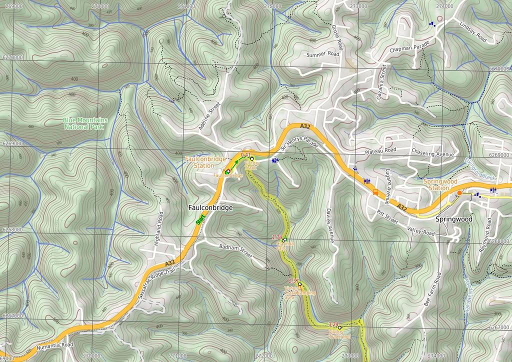
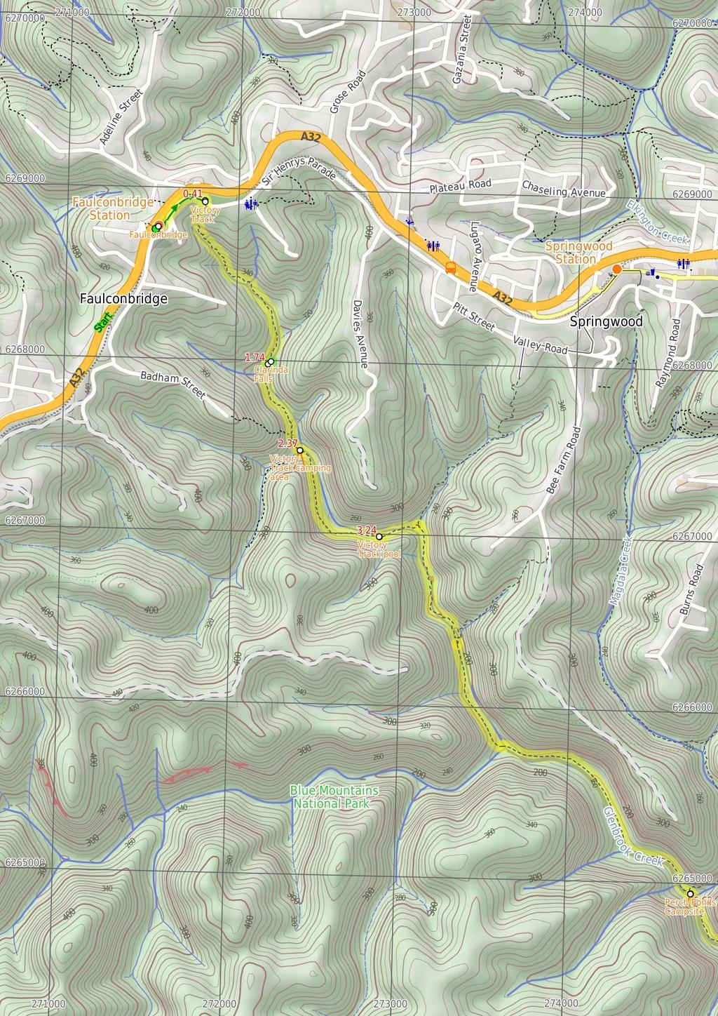
2 Faulconbridge Before You walk Faulconbridge, in the Blue Mountains, New South Wales, was named after the maiden name of Sir Henry Parkes' mother. Faulconbridge sits on the Great Western Highway and is surrounded by valleys of lush bushland. This picturesque town was a home, and final resting place, for Sir Henry Parkes', heralded as the 'Father of Federation'. Faulconbridge was originally explored by nonindigenous Australians in 1813, by Blaxland, Wentworth and Lawson who were searching for a route over the Blue Mountains. Bushwalking is fun and a wonderful way to enjoy our natural places. Sometimes things go bad, with a bit of planning you can increase your chance of having an ejoyable and safer walk. Before setting off on your walk check Victory Track The Victory Track is more formally know as the 'Sir Henry Parkes Victory Track' and is called the 'Victoria Track' in many guide books. The track starts near Sir Henry Parkes' grave in Faulconbridge and leads to Sassafrass Gully Creek. Sir Henry Parks ( ) was a politician and journalist, born in England. He is considered to be the 'Father of Federation' for Australia, although he died of natural causes 5 years before Australia's federation. Parkes was the premier of New South Wales five times. The town Parkes was named in his honour. Parkes would sometime write under the pseudonym 'Faulconbridge' (his mothers maiden name) for the Sydney Morning Herald and other papers and Faulconbridge (the township) was named after his mother when Parkes purchased 600 acres in More info. Clarinda Falls Clarinda Falls is a charming waterfall on Sassafras Creek. The water cascades over a near-vertical wall, into a sandy pool below. The falls are signposted from the main track and provide a nice cool detour, especially on warmer days. The falls are named for the first wife of Sir Henry Parkes, 'Father of Australian Federation'. Victory Track camping area Victory Track camping area is a fairly large, informal camping place at the junction of Sassafras and Numantia Creeks. The clearing is in a moist section of forest with plenty of shade. Water from the creek should be treated before use. Victory Track pool The Victory Track pool is an unofficially-named pond in Sassafras Creek. The pond is deep in parts but not adequate for a swim. It does, however, offer a chance to rest and gaze over the water. There is a small sandy beach, some moss-covered rocks and a lovely grove of Sassafras trees around the pool. This is a nice spot to stop, catch your breath and soak up your surroundings. 1) Weather Forecast (BOM Central Tablelands District) 2) Fire Dangers (Greater Sydney Region) 3) Park Alerts (Blue Mountains National Park) 4) Research the walk to check your party has the skills, fitness and equipment required 5) Agree to stay as a group and not leave anyone to walk solo Think before you TREK The 'Think before you TREK' program developed by NSW Police & NPWS promotes the benefits of planning ahead for your bushwalking trip by using an easy to remember acronym: adequate supplies of food, water, navigation and first T Take aid equipment. your planned route and tell friends and family when R Register you expect to return. beacon (PLB's) should be carried on walks with E Emergency significant gaps in mobile coverage (check terrain profile). to your planned route and follow the map and walking K Keep trails. Topo Maps The maps provided on wildwalks are helpful, but there are times where you may need maps covering a broader area. Maps that cover this walk include; 1: Map Series:90304S SPRINGWOOD, 90303N PENRITH 1: Map Series:9030 PENRITH Grade This walk has been graded using the AS The overall grade of the walk is dertermined by the highest classification along the whole track. 5 Grade 5/6 Experienced only Length 15.2 km One way Time 2 Days Quality of track Rough unclear track (5/6) Signs No directional signs (5/6) Experience Required Moderate level of bushwalking experience recommended (4/6) Weather Storms may impact on navigation and safety (3/6) Infrastructure No facilities provided (5/6) * This walk passes through very remote areas and sections have no visible track. At least one person in your group should have training and experience in off track walking and navigation. Even with these notes and a GPS these extra skills and equipment are required.
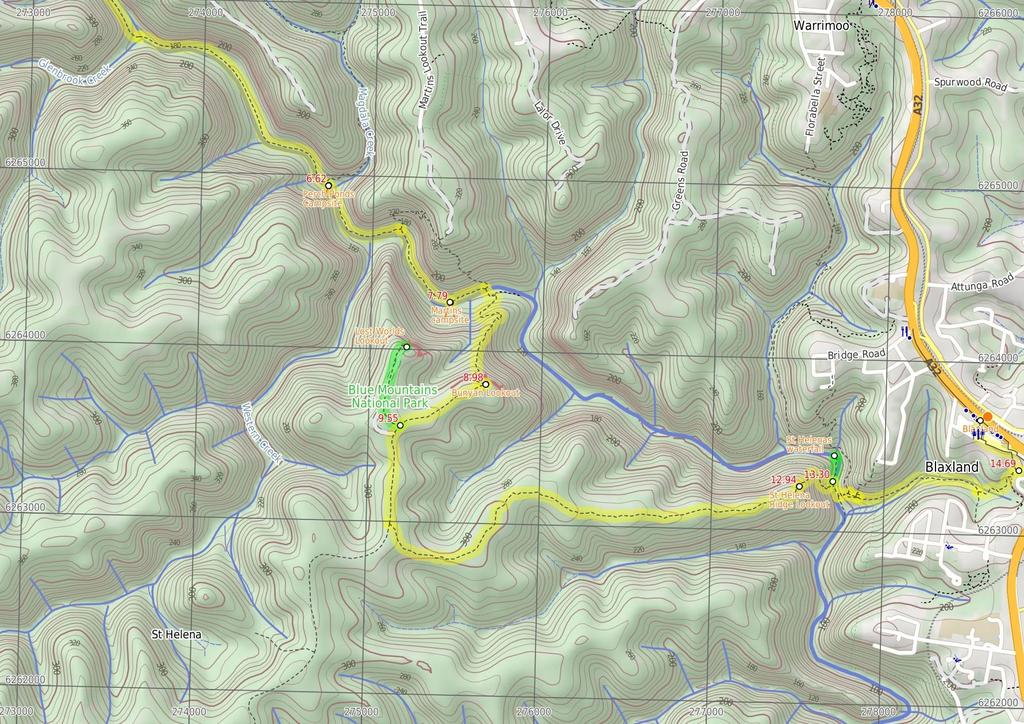
3 Are you ready to have fun? Please ensure you and your group are well prepared and equipped for all possible hazards and delays. Check park closures, weather information and Fire Danger Rating before setting out. Optional side trips and alternate routes noted are not included in this walks overall grade, length or time estimate. Please allow extra time for resting and exploring areas of interest. The authors, staff and owners of wildwalks take care in preparing this information but will not accept responsibility for any inconvenience, loss or injury you may experience. Please take care, have fun - Happy Walking. Experainced walkers only: This walk passes through very remote areas and sections have no visible track. At least one person in your group should have training and experience in off track walking and navigation. Even with these notes and a GPS these extra skills and equipment are required. Getting there You can get to Faulconbridge Station (gps: , ) by car, train or bus. Car: There is free parking available. You can get back from Blaxland Station (gps: , ) by car, train or bus. Car: There is free parking available. Find up to date and more information inlcuding; travel directions, weather, park closures and walker feedback at 0 Faulconbridge Faulconbridge, in the Blue Mountains, New South Wales, was named after the maiden name of Sir Henry Parkes' mother. Faulconbridge sits on the Great Western Highway and is surrounded by valleys of lush bushland. This picturesque town was a home, and final resting place, for Sir Henry Parkes', heralded as the 'Father of Federation'. Faulconbridge was originally explored by non-indigenous Australians in 1813, by Blaxland, Wentworth and Lawson who were searching for a route over the Blue Mountains. 0 Faulconbridge Station (410 m 8 mins) From the top of Faulconbridge Station, the walk heads off the station overpass to the bushland side of the station (if you come to a car park, you have gone to the wrong side of the station). The walk then keeps the rail line on the left as it follows the footpath down to the road. After a while, the walk comes to an intersection with Sir Henrys Pde, opposite house number Victory Track The Victory Track is more formally know as the 'Sir Henry Parkes Victory Track' and is called the 'Victoria Track' in many guide books. The track starts near Sir Henry Parkes' grave in Faulconbridge and leads to Sassafrass Gully Creek. Sir Henry Parks ( ) was a politician and journalist, born in England. He is considered to be the 'Father of Federation' for Australia, although he died of natural causes 5 years before Australia's federation. Parkes was the premier of New South Wales five times. The town Parkes was named in his honour. Parkes would sometime write under the pseudonym 'Faulconbridge' (his mothers maiden name) for the Sydney Morning Herald and other papers and Faulconbridge (the township) was named after his mother when Parkes purchased 600 acres in More info No. 10 Sir Henrys Pde (1.3 km 38 mins) Turn right: From 10 Sir Henrys Pde (bushland side), the walk follows the 'Victory Track' sign down into the bush. The walk passes under a few rock overhangs and then crosses a creek. Passing a smaller track (on the left, which leads to the top of the falls), the walk soon comes down to a 'Clarinda Falls' sign Optional sidetrip to Clarinda Falls (30 m 1 mins) Turn left: From the intersection, the track follows the 'Clarinda Falls' sign towards the log fallen on the rock. The track tends left around the hillside, coming to Clarinda Falls. At the end of this side trip, retrace your steps back to the main walk then Continue straight Clarinda Falls Clarinda Falls is a charming waterfall on Sassafras Creek. The water cascades over a near-vertical wall, into a sandy pool below. The falls are signposted from the main track and provide a nice cool detour, especially on warmer days. The falls are named for the first wife of Sir Henry Parkes, 'Father of Australian Federation' Int. Victory Trk and Clarinda Falls (630 m 18 mins) Turn right: From the intersection, the walk follows the 'Sassafras Gully' sign down the hill. The track keeps the creek on the left as it continues down the gully then crosses a creek junction. The walk meanders down the hillside and soon crosses a larger creek junction, before entering a campground clearing (beneath power lines) Victory Track camping area Victory Track camping area is a fairly large, informal camping place at the junction of Sassafras and Numantia Creeks. The clearing is in a moist section of forest with plenty of shade. Water from the creek should be treated before use Victory Trk camping area (880 m 24 mins) Continue straight: From the campground clearing, the walk follows the creek, keeping it to the left. The track winds up the hill and back down to the creek a few times and soon comes to an intersection with a faint track on the left (which leads to a pool in the creek) Victory Track pool The Victory Track pool is an unofficially-named pond in Sassafras Creek. The pond is deep in parts but not adequate for a swim. It does, however, offer a chance to rest and gaze over the water. There is a small sandy beach, some moss-covered rocks and a lovely grove of Sassafras trees around the pool. This is a nice spot to stop, catch your breath and soak up your surroundings Victory Trk pool (3.4 km 1 hr 11 mins) Continue straight: From the intersection, the walk heads down the valley, keeping the creek on the left. The walk soon turns left, crosses the creek and continues down the valley, with the creek now on the right. Leading down the valley, the track then crosses a gully to arrive at a blue 'Faulconbridge Station' sign (pointing back the way you came). Turn right: From the intersection, the walk heads down across the creek in the direction of the 'To Wiggins Track' sign. The walk winds along the hillside, keeping the creek on the right, passing a blue track marker which directs the walk to the other side of the creek. The walk now keeps the creek on the left as it winds up to a 'Perch Ponds, Springwood Stn' sign. Veer right: From the intersection, the walk follows the direction of the 'Perch Ponds' sign across the hillside. The walk soon nears the creek on the left, then undulates above it for a short while. The track crosses a steeply banked creek junction, then continues following the main creek (which is on the left). The walk stays near this creek, coming into a campground clearing with large boulders. Continue straight: From the campground clearing, the walk exits the clearing, keeping the main creek to the right, and immediately crosses a side creek. The walk keeps the main creek on the right as it slowly climbs the hillside. The track then heads downhill, passing under a few rock overhangs and soon entering the campground clearing of 'Perch Ponds' Perch Ponds Campsite Perch Ponds is a lovely waterhole, with a clearing suitable to pitch a tent, located at the junction of Magdala Creek and Glenbrook Creeks. The meeting of the two creek provides a relaxing sound of rushing water and a cool spot to rest on warmer days. The campsite is a flat area above the pool marked with a fire scar. A great shady and quiet area for a camp. There are no facilities and water from the creek needs to be treated Perch Ponds camping area (1.2 km 27 mins) Continue straight: From the intersection, the walk follows the direction of the 'Martins Lookout' sign across the campground clearing to an arrow bolted to a tree. The walk follows this arrow down the hill and across the creek, and then follows creek, keeping it on the right. The walk leads up the hill away from the creek to a signposted intersection for 'Martins Lookout'. Veer right: From the intersection, the walk follows direction of the 'Long Track' sign, down the hill. The track winds down near the creek and passes a sandy beach access before soon entering a second clearing Martins campsite Martins campsite is an unofficial camping area beside Glenbrook Creek. The camping area is a sandy clearing, opposite cliffs on the other bank. The camping area is situated below Martins Lookout, with Bunyan Lookout up the ridge on the opposite hillside. A quiet and shaded location which can give a great night's sleep End of day 1 This is the planned overnight stay for the end of day 1, happy camping.
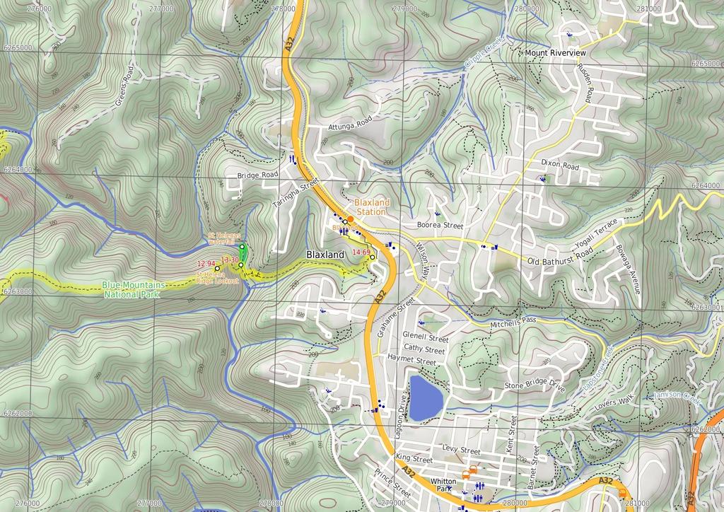
4 7.79 Martins camping area (1.2 km 44 mins) Turn left: From the fireplace, the walk heads along the creek bank, keeping the creek near and on the right. The walk then tends left, up the hill to the intersection and pole without a sign. Veer right: From the intersection, the walk follows the 'Bunyan Lkt' post down the stairs. The walk soon meets the creek and turns left, following the creek for a short distance before crossing at an opening in the shrubs around the creek. From here, the walk follows the cairns (rock stacks) across creek flats before climbing the hill to the base of a small cliff line. At one point beneath the cliff line, the walk ducks through a hole in the rock, then winds up through boulders, following more cairns. The walk continues up the hill, passing through a few more rocky outcrops to reach the informal, unfenced Bunyan Lookout, in a clearing near the cliff line Bunyan Lookout Bunyan Lookout is an large, unfenced sandstone platform overlooking the Glenbrook Creek valley. Behind the lookout, there is a small sandy clearing, big enough for a few tents. The lookout spans across Glenbrook Creek and sandstone cliffs of the valley Bunyan Lookout (570 m 10 mins) Turn sharp right: From Bunyan Lookout, the walk heads back into the clearing behind the unfenced cliff line and turns left at the cairn (if you head down into the valley, you have gone the wrong way). The walk meanders through the heath for a short time before coming to a red painted stump, on the right of the track Optional sidetrip to Lost Worlds Lookout (570 m 11 mins) Turn right: From the red stump intersection, the walk follows the 'Lost Worlds' sign up the small hill. The walk winds through the bush for a short time then crosses a rocky surface. The track then leaves the rocky surface briefly to return to a similar rock surface with a white crucifix on the edge of the cliff. At the end of this side trip, retrace your steps back to the main walk then Turn right Lost Worlds Lookout Lost Worlds Lookout is a cliff edge marked by a cross. The cross commemorates the Rev. Raymer who was a prominent bushwalker in the area, and has been commemorated by a plaque at Martins Lookout across the valley. The lookout views Glenbrook Creek valley below, the surrounding cliffs and down to Penrith in the west Int. Bunyan Lookout Trk and Lost Worlds Trk (3.4 km 59 mins) Continue straight: From the intersection, the walk heads in a southerly direction away from the red stump, keeping it behind on the right of the track. The walk winds through the bush, crossing a few sandy areas that lead to a small cairn marking the intersection, on the left of the track. Veer left: From the intersection, this walk heads south east along track soon leading downhill. The walk meanders through the heath for quite some time. The walk nears a cliff line on the left, which it continues near for a short time before opening out onto a rocky outcrop with a view across to houses on the opposite hill (just before the steep downhill section) St Helena Ridge Lookout St Helena Ridge Lookout, does not have the clearest view or the most spectacular scenery. However, it is a great place to rest before continuing on your way St Helena Ridge Lookout (360 m 18 mins) Continue straight: From St Helena Ridge lookout, the walk follows a very faint track initially very steeply down off the rock platform, The track initially tends a little to the left to then follow the main ridge line down. The track soon becomes much less steep (and a little clearer) when after about 100m the faint track bends right at another rocky outcrop. Here the walk leads off the side of the ridge to then wind down through the rocky outcrops and continue down through the scrub for about 180m until just before Glenbrook Creek where this walk comes to an un-signposted intersection Optional sidetrip to St Helena waterfall (160 m 3 mins) Veer left: From the intersection, the walk heads upstream, keeping the creek on the right. The track undulates along the bank, passing a few large boulders in the creek before coming to a sandy beach at a bend in the creek. Continue straight: From the beach, the walk heads across the sand bar (covered in reeds) to come within ear-shot of the waterfall, located behind the inlet on the creek. The walk passes through the sandy, shallow section of the creek then walks up the bank and around to the waterfall. At the end of this side trip, retrace your steps back to the main walk then Continue straight St Helenas waterfall St Helenas waterfall is a small fall, flowing from a side creek into Glenbrook Creek. It is rather unimpressive unless there has been recent rainfall. The water cascades down a nice rock face, among the sassafras trees and mossy rocks Int. Waterfall and ridge trk (1.4 km 34 mins) Turn right: From the intersection, the walk heads downstream, keeping the creek on the left. After approximately 10m, the walk comes to a bushy creek crossing and winds over the rocks and through the bushes. Following this, the walk keeps the creek on the right whilst winding downstream. The track soon arrives at an intersection, which is a sandy area with rocks and stairs leading up the hill. Turn left : From the large boulder, this walk heads up the hill and climbs the stone steps steeply, with a number of pink ribbons marking the initial track. The track continues steeply (eroded in places) up the hill and winds its way up to the un-signposted T-intersection. Turn sharp right: From the intersection, this walk heads along the mostly flat track along the side of the hill, keeping the valley to your right. Soon the track leads to another intersection at the base of more stone steps, and a rock wall (on the left) that has 'Florabella Pass' engraved in it. Continue straight: From the intersection, the walk heads around the boulder (which is on the left) and soon meets a set of stairs, to the left of a 'Pippas Pass' sign in a tree. Turn right: From the intersection, this walk follows the 'Pippas Pass' sign (that is about 2m up a tree) gently downhill along the track, directly away from the rockface, keeping the main valley to your right. The track winds along the side of the hill for about 100m to then climb up a set of sandstone steps just past a shallow sandstone overhang. From here the track gently undulates along the side of the hill (with a steep valley to your right) for about 300m to lead gently down and cross the usually small creek in the shaded valley. Just after crossing this creek, the track bends left to head gently up through the valley along the base of a few natural sandstone walls for about 200m, where the the track becomes rocky and starts to climb a bit more steeply. The track then leads up through a cleft in the rock then about 60m later comes to a unsignposted three-way intersection (with the track on the left crossing the creek), marked with a smooth bark Angophera. Turn left: From the intersection, this walk crosses the sandstone platform and creek. Here the track winds gently uphill for about 40m to cross a smaller often dry creek where the track continues uphill for another 30m to pass a grafittied sandstone overhang (on your left). The track continues gently uphill and bends right to cross a sandstone rock platform and small creek to almost immediately come to a faint intersection with a track in the tall heath. Here the walk turns left and heads uphill for for about 50m where the track then leads up some steps to come to the base of a sandstone cliff and smaller overhang. Here the track bends left and and continues along the side of the hill for another 15m to pass a larger and more grafittied sandstone overhang. From here the track continues to wind more steeply uphill for about 80m before turning left and following a wider track (away from the houses) and into the lower car park of Blaxland library just past the 'Bushcare site' information sign. Here this walk turns right to head up to the library and main car park Blaxland Library Carpark (460 m 9 mins) Turn left: From the Blaxland Library car park, this walk heads up the ramp on the side of the building then follows the back deck behind the library and community centre. On the far side of the building, this walk follows the bitumen footpath footpath uphill to turn left at the 'Blaxland Civic Centre' sign onto the footpath beside Hope St. This walk follows the footpath uphill for about 150m before turning right to cross Hope St at the traffic calming device. Here the walk bends left and crosses a car park entrance, then soon turns right into 'Station St'. Here the walk heads up the footpath to cross another car park entrance then onto the pedestrian lane way that leads between the buildings, under the foot bridge to the main footpath, just before the Great Western Highway, among the Blaxland shops Blaxland Blaxland, found along the Great Western Highway, is one of the larger towns of the Lower Blue Mountains. The town has a number of shops and petrol station all lining the highway which lies between the town and train station. Wascoe was the original name of Blaxland until 1914 when it was renamed after Gregory Blaxland who was one of the explorers who found the route across the mountains for the colony. The Blaxland community hosts a number of events during the month of September. More info Blaxland Shops (70 m 1 mins) Turn left: From the footpath, the walk uses the stairs or ramp to climb onto the pedestrian bridge. The walk then crosses the bridge over the Great Western Highway and then heads down onto Blaxland Station.
5
6
7
8
9 Summary navigation sheet for the Faulconbridge to Blaxland km From Start Faulconbridge Station , (GR Springwood, ) 0.41 No. 10 Sir Henrys Pde , (GR Springwood, ) 1.74 Int. Victory Trk and Clarinda Falls , (GR Springwood, ) 1.74 Int. Victory Trk and Clarinda Falls , (GR Springwood, ) 2.37 Victory Trk camping area , (GR Springwood, ) 3.24 Victory Trk pool , (GR Springwood, ) 6.62 Perch Ponds camping area , (GR Springwood, ) 7.79 End of day , (GR Springwood, ) 7.79 Martins camping area , (GR Springwood, ) 8.98 Bunyan Lookout , (GR Springwood, ) 9.55 Int. Bunyan Lookout Trk and Lost Worlds Trk , (GR Springwood, ) 9.55 Int. Bunyan Lookout Trk and Lost Worlds Trk , (GR Springwood, ) St Helena Ridge Lookout , (GR Springwood, ) Int. Waterfall and ridge trk , (GR Springwood, ) Int. Waterfall and ridge trk , (GR Springwood, ) Blaxland Library Carpark , (GR Springwood, ) Blaxland Shops , (GR Springwood, ) Powered by TCPDF ( Up/Dwn Length Initial directions (Use full tracknotes and maps for more detail) m 8 mins 1.3 km 38 mins 30 m 1 mins 630 m 18 mins 880 m 24 mins 3.4 km 1 hr 11 mins 1.2 km 27 mins 0m 1.2 km 44 mins 570 m 10 mins 570 m 11 mins 3.4 km 59 mins 360 m 18 mins 160 m 3 mins 1.4 km 34 mins 460 m 9 mins 70 m 1 mins From the top of Faulconbridge Station, the walk heads off the station overpass to the bushland side of the station (if you come to a car park, you have gone to the wrong side of the station). Turn right: From 10 Sir Henrys Pde (bushland side), the walk follows the 'Victory Track' sign down into the bush. Optional sidetrip to Clarinda Falls. Turn left: From the intersection, the track follows the 'Clarinda Falls' sign towards the log fallen on the rock. Turn right: From the intersection, the walk follows the 'Sassafras Gully' sign down the hill. Continue straight: From the campground clearing, the walk follows the creek, keeping it to the left. Continue straight: From the intersection, the walk heads down the valley, keeping the creek on the left. Continue straight: From the intersection, the walk follows the direction of the 'Martins Lookout' sign across the campground clearing to an arrow bolted to a tree. This is the planned overnight stay for the end of day 1, happy camping. Turn left: From the fireplace, the walk heads along the creek bank, keeping the creek near and on the right. Turn sharp right: From Bunyan Lookout, the walk heads back into the clearing behind the unfenced cliff line and turns left at the cairn (if you head down into the valley, you have gone the wrong way). Optional sidetrip to Lost Worlds Lookout. Turn right: From the red stump intersection, the walk follows the 'Lost Worlds' sign up the small hill. Continue straight: From the intersection, the walk heads in a southerly direction away from the red stump, keeping it behind on the right of the track. Continue straight: From St Helena Ridge lookout, the walk follows a very faint track initially very steeply down off the rock platform, The track initially tends a little to the left to then follow the main ridge li... Optional sidetrip to St Helena waterfall. Veer left: From the intersection, the walk heads upstream, keeping the creek on the right. Turn right: From the intersection, the walk heads downstream, keeping the creek on the left. Turn left: From the Blaxland Library car park, this walk heads up the ramp on the side of the building then follows the back deck behind the library and community centre. Turn left: From the footpath, the walk uses the stairs or ramp to climb onto the pedestrian bridge.
Little Digger Track. 68m. 1 Hr 2.2 km One way. Moderate track 93m. Moores Creek Reserve
 Little Digger Track Hr 2.2 km One way Moderate track 93m This walk follows Moores Creek through several reserves in east Roseville and East Lindfield. The track is named after Australia's 7th Prime Minster,
Wentworth Falls Conservation Hut Loop
 Wentworth Falls Conservation Hut Loop 3 hrs Hard track 6.7 km Circuit 4 341m This scenic walk from Wentworth Falls Station, winds along the Nature Trail to Conservation Hut, then drops into the magnificent
Govetts Leap Loop. 1065m. 909m Blue Mountains National Park. 4 hrs 30 mins 8.7 km Circuit. Hard track 380m
 Govetts Leap Loop 4 hrs 30 mins 8.7 km Circuit Hard track 380m This walk, from Blackheath Train Station, is a fantastic way to see some of the iconic areas of the Blue Mountains in the Blackheath area.
Popes Glen, Pulpit Rock, Govetts Leap and Braeside Walk
 Popes Glen, Pulpit Rock, Govetts Leap and Braeside Walk 8 hrs Hard track 13.6 km Circuit 4 1068m This large circuit walk, from Popes Glen to Pulpit Rock, Govetts leap and along the Braeside Track, passes
Carrington Park to Leura Forest and pass loop
 Carrington Park to Leura Forest and pass loop 3 hrs Hard track 4.8 km Circuit 4 674m This walk is a fantastic way to see Leura Forest. The walk descends from Carrington Park, visiting Leura Forest and
Echo Point to Leura Forest via Three Sisters and Giant Stairs loop
 Echo Point to Leura Forest via Three Sisters and Giant Stairs loop 3 hrs 3.8 km Circuit Hard track 512m This walk starts from the popular Echo Point, in Katoomba, and winds down to the base of the Three
Hunters Hill to Epping Road
 Hunters Hill to Epping Road 2 hrs 30 mins 5.5 km One way Moderate track 154m An enjoyable walk through lower sections of the Lane Cove National Park, this walk features plenty of mangroves next to the
Waterfall to Heathcote
 Waterfall to Heathcote 5 hrs Hard track 10.8 km One way 4 467m This walk explores the heart of Heathcote National Park, and is easily accessed with a train station at either end. Although relatively close
Hornsby Blue Gum Walk
 Hornsby Blue Gum Walk 3 hrs Hard track 6.7 km Circuit 4 374m This delightful loop is one of the prettiest and most popular walks in the Hornsby area. Going from an environment of ferns and clear bushland
Currie Rd to Davidson Park
 Currie Rd to Davidson Park 3 hrs 7.2 km One way Moderate track 28m Starting at Currie Rd in Forestville, this walk follows Middle Harbour to Davidson Park, under Roseville Bridge. There are two optional
Wattamolla to Big Marley Beach
 Wattamolla to Big Marley Beach 4 hrs 10.4 km Circuit Moderate track 4m This walk is an excellent loop which takes in both the coast and the heathy inland of Royal National Park. Nearly the whole walk has
Little Digger Track to Davidson Reserve and Lyrebird Circuit
 Little Digger Track to Davidson Reserve and Lyrebird Circuit 4 hrs 3 mins 11.5 km One way Hard track 4 47m Exploring both the eastern and western sides of Middle Harbour Creek, this walk follows the Little
The Basin Track and Mackerel Track
 The Basin Track and Mackerel Track 3 hrs 5.9 km Circuit Hard track 226m This walk is a great way to see some popular areas in Ku-ring-gai Chase National Park. The walk from West Head Rd travels to The
Rail to River Walk. 3 hrs. Hard track 7.5 km Circuit. 222m
 Rail to River Walk 3 hrs Hard track 7.5 km Circuit 4 222m This walk is a great one from Chatswood Station to the Lane Cove River National Park. The walk descends through the vegetated bushland which fills
Epping to Eastwood Station (via Lane Cove River)
") Epping to Eastwood Station (via Lane Cove River) hrs 45 mins 10.2 km One way Moderate track 189m Epping to Eastwood, via Lane Cove River, is the longer route through the bush between the stations. This
Epping to Eastwood Station (via Lane Cove River) hrs 45 mins 10.2 km One way Moderate track 189m Epping to Eastwood, via Lane Cove River, is the longer route through the bush between the stations. This
Heathcote to Engadine via Audley
 Heathcote to Engadine via Audley 6 hrs 3 mins 5 km One way Hard track 4 635m Covering a large section of central Royal National Park, this walk goes through the heath and scrub along a well managed and
Campbell Drive to Snapper Point
 Campbell Drive to Snapper Point 1 hr 45 mins 4.2 km One way Experienced only 135m This walk follows the Coast Track to Frazer Beach, along the Geebung and (overgrown) Grass Tree Tracks. From the northern
Epping to Pennant Hills Station (via Lane Cove River)
") Epping to Pennant Hills Station (via Lane Cove River) 3 hrs 5 mins 8.4 km One way Hard track 249m This walk, from Epping to Pennant Hills Station, is a great way to see the upper Lane Cove River Valley.
Epping to Pennant Hills Station (via Lane Cove River) 3 hrs 5 mins 8.4 km One way Hard track 249m This walk, from Epping to Pennant Hills Station, is a great way to see the upper Lane Cove River Valley.
Mackerel Beach, West Head Loop
 Mackerel Beach, West Head Loop 5 hrs 8.6 km Circuit Hard track 422m The Mackerel Beach, West Head Loop is a walk which explores a large part of the West Head. The journey starts and finishes with a ferry
Sid Pulsford Walk. 175m. 33m. 1 hr 45 mins 4.1 km One way. Hard track 118m. Gosford LGA
 Sid Pulsford Walk 1 hr 5 mins.1 km One way Hard track 118m Sid Pulsford Walk explores the ridge top of Kincumber Mountain, from Honeman's Rock to Green Point. The walk mostly follows wide management trails.
Katoomba Falls Circuit
 Katoomba Falls Circuit hr 5 mins.5 km Circuit Hard track 59m For those looking for a walk involving more than simple boardwalk, this trail winding through the temperate rain forest could be just the thing.
Blackheath Station to Junction Rock Loop (via Grand Canyon and Popes
 Blackheath Station to Junction Rock Loop (via Grand Canyon and Popes 8 hrs 30 mins 18.2 km Circuit Hard track 4 1254m This circuit starts in Blackheath and heads down into the Grand Canyon and Rodriguez
Wallarah Coastal Walk
 Wallarah Coastal Walk 3 hrs 8.3 km Return Hard track 247m This walk starts at Caves Beach and travels south along the coastline, until reaching the Pinney s Headland Lookout. There are many opportunities
Dead Horse Gap Loop track
 Dead Horse Gap Loop track 4 hrs 30 mins Hard track 9.8 km Circuit 144m 4 This walk starts with a ride up the Kosciuszko Express Chairlift. There is an opportunity to eat at Australia's highest restaurant,
Rail to River and Stringybark Creek Reserve Walk
 Rail to River and Stringybark Creek Reserve Walk 4 hrs Hard track 11.2 km Circuit 4 302m This walk begins in the busy city of Chatswood and soon enters the nearby bushland around the Lane Cove River. The
Glenbrook and Euroka Circuit
 Glenbrook and Euroka Circuit 2 Days 16.6 km Circuit Experienced only 790m This two day circuit, returning to Glenbrook Station, is a scenic walk which passes many of the tourist attractions within the
Morgans Creek to Padstow
 Morgans Creek to Padstow 2 hrs 45 mins 8 km One way Moderate track 3 144m This pleasant walk starts from the Morgans Creek park, at Henry Lawsons Drive, and follows the Georges River past the Boomerang
National Pass from Wentworth Falls to Conservation Hut
 National Pass from Wentworth Falls to Conservation Hut 3 hrs Hard track 3.6 km One way 739m Starting at Wentworth Falls picnic area, this scenic and historic walk explores many waterfalls, lookouts and
Callicoma Loop. 174m. 98m. 2 hrs. Hard track 5.1 km Circuit. 153m
 Callicoma Loop 2 hrs Hard track 5.1 km Circuit 153m This great circuit walk passes through some really nice forest around the fringe of Cherrybrook. Highlights of the walk include some beautiful rock overhangs
Middle Harbour Creek Loop
 Middle Harbour Creek Loop 5 hrs 45 mins 15.1 km Circuit Experienced only 5 570m This walk explores the upper reaches of Middle Harbour Creek, starting and ending at the great parklands at Davidson Park,
Scenic World to Echo Point
 Scenic World to Echo Point 1 hr 15 mins 2.1 km One way Moderate track 192m This is one of the most popular tourist walks in the Katoomba area. The walk follows the cliffs along a well maintained and signposted
Balmoral Beach to The Spit
 Balmoral Beach to The Spit 2 hrs 30 mins.3 km One way Hard track 85m This walks follows the coast from Balmoral to the Spit and across Spit Bridge. There are some alternate tracks to consider at high-tides,
De Burgs Bridge to Thornleigh station
 De Burgs Bridge to Thornleigh station 3 hrs 45 mins 9.7 km One way Hard track 4 363m This walk follows a section of the Great North Walk, starting from De Burghs bridge. The walk winds north west, through
Mackerel Beach and Resolute Loop
 Mackerel Beach and Resolute Loop 3 hrs 5.4 km Circuit Hard track 384m This walk is another great walk in Ku-ring-gai Chase National Park, accessed by ferry. From the Mackerel Beach wharf, this walk uses
Under and Over Cliff Walk
 Under and Over Cliff Walk 4 hrs 9.4 km Circuit Moderate track 576m This walk from Wentworth Falls Station is a fantastic way to see a large majority of the Wentworth Falls cliffline. The track winds under
Wentworth Falls Station Loop (Undercliff Walk)
") Wentworth Falls Station Loop (Undercliff Walk) 4 hrs 3 mins Hard track 8.9 km Circuit 658m 4 This walk passes some stunning waterfalls and views into the Jamison Valley, following the cliff edges around
Wentworth Falls Station Loop (Undercliff Walk) 4 hrs 3 mins Hard track 8.9 km Circuit 658m 4 This walk passes some stunning waterfalls and views into the Jamison Valley, following the cliff edges around
The Foreshore Walk. 24m. 1m Lake Macquarie LGA. 1 hr 15 mins 2.9 km One way. Hard track 81m
 The Foreshore Walk 1 hr 15 mins 2.9 km One way Hard track 81m This walk traverses the coastline of the Green Point reserve. By following a variety of tracks and occasionally traveling inland through eucalyptus
Bouddi Coastal Walk. 5 hrs. Hard track 8.1 km One way. 364m
 Bouddi Coastal Walk 5 hrs Hard track 8.1 km One way 4 364m This is one of the longer walks in the Bouddi National Park and it is rich in scenery. The walk follows the coastline with many side trips to
Sphinx, Warrimoo and Bobbin Head tracks
 Sphinx, Warrimoo and Bobbin Head tracks 4 hrs 9.6 km Circuit Moderate track 499m This great walk starts at the Sphinx Memorial and loops around via Cowan Creek, exploring diverse environments as it changes
Patonga to Woy Woy. 5 hrs 45 mins 15.5 km One way. Hard track. 497m
 Patonga to Woy Woy 5 hrs 45 mins 15.5 km One way Hard track 4 497m This walk explores a variety of environments from the shore line and coastal cliffs near Patonga, to the dry, rocky and open ridge line.
De Burghs Bridge to Fullers Bridge
 De Burghs Bridge to Fullers Bridge 2 hrs 3 mins Hard track 6 km One way 2m 4 Following the Lane Cove River, this walk mostly follows a section of the Great North Walk and is well maintained and signposted.
Berowra to Mt Kuring-gai
 Berowra to Mt Kuring-gai 4 hrs 30 mins 9.4 km One way Hard track 4 551m From the ridges above Cowan Creek, this walk takes in some great lookouts (especially around Mt Kuringgai) as well as enjoying an
Teralba to Charlestown Park track head
 Teralba to Charlestown Park track head 4 hrs 30 mins 13.3 km One way Moderate track 3 220m This section of the Great North Walk starts from the Teralba train station and winds down and around the edge
Dubbo Gully and Ten Mile Hollow Circuit (via Clares Bridge)
") Dubbo Gully and Ten Mile Hollow Circuit (via Clares Bridge) 2 Days Hard track 24.3 km Circuit 4 1117m This two day (or ten hour) walk follows several historic roads, now closed to traffic. Starting with
Dubbo Gully and Ten Mile Hollow Circuit (via Clares Bridge) 2 Days Hard track 24.3 km Circuit 4 1117m This two day (or ten hour) walk follows several historic roads, now closed to traffic. Starting with
Upper Rumbalara circuit
 Upper Rumbalara circuit 1 hr 30 mins 3.3 km Circuit Hard track 176m A great circuit walk, covering most of the walking tracks and sights in the upper section of the Rumbalara Reserve. There is some really
Epping to Gordon Station
 Epping to Gordon Station 4 hrs 15 mins 11.7 km One way Hard track 4 365m This walk, from Epping Station to Gordon Station, passes below the homes which sit on the hills high above the Lane Cove River.
Federal Pass Walking Track
 Federal Pass Walking Track 5 hrs Hard track 8 km One way 4 989m This classic trail follows along the base of the cliffs from Leura to the Golden Stairs, passing many of the more popular sights of the Katoomba
Spit Bridge to Middle Head Forts
 Spit Bridge to Middle Head Forts 2 hrs 30 mins 6.3 km One way Hard track 4 181m This scenic walk takes you from the Spit Bridge, along the coast to explore the Middle Head Forts. There are a few alternate
Wentworth Falls Station Loop
 Wentworth Falls Station Loop 5 hrs 3 mins 9.5 km Circuit Hard track 4 13m The Wentworth Falls Station Loop takes in most of the upper tracks around Wentworth Falls. There are many scenic views near the
Roseville to Macquarie Park
 Roseville to Macquarie Park 3 hrs 3 mins 8.8 km One way Hard track 4 29m This walk starts at Roseville station and explores the streets and alleyways of Roseville before joining the main spine of the Great
Thornleigh to Hornsby
 Thornleigh to Hornsby 4 hrs Hard track 10.2 km One way 4 526m Starting at Thornleigh station you walk through suburban streets for a short while before diving into the bush at the southern end of Berowra
Taronga Wharf to Chowder Bay
 Taronga Wharf to Chowder Bay 2 hrs 4.4 km One way Moderate track 246m Starting at Taronga Wharf, this walk passes many icons of Sydney, including Taronga Zoo, HMAS Sydney Mast, Chowder Bay. The walk also
Echo Point to Leura Forest Circuit
 Echo Point to Leura Forest Circuit 3 hrs 4.8 km Circuit Hard track 588m Forming a circuit around the cliffs and then the valley floor, this is a walk more then capable of convincing a walker of the beauty
Green Point Circuit Walk
 Green Point Circuit Walk 3 hrs 7.7 km Circuit Hard track 269m This walk visits all of the popular locations in Green Point Reserve, as well as some of the lesser-visited areas inland. Taking in Sea Eagle
Gordon to Chatswood Station
 Gordon to Chatswood Station 4 hrs 30 mins 12.2 km One way Hard track 4 381m This walk is a great way to get into the bush without being far from civilisation. The walk wanders through untouched valleys
Wentworth Falls Loop. 893m. 665m. 6 hrs 10.2 km Circuit. Hard track 1093m. Blue Mountains National Park
 Wentworth Falls Loop 6 hrs 1.2 km Circuit Hard track 193m This is a great walk, both in size and spectacular views. The walk makes its way from Wentworth Falls train station and drops off the plateau,
Lane Cove Tourist Park River Circuit
 Lane Cove Tourist Park River Circuit 5 hrs 12 km Circuit Hard track 383m This walk follows a large section of Lane Cove River. The walk follows the Riverside Walking track up the Lane Cove River to De
Woolwich Wharf to Boronia Park
 Woolwich Wharf to Boronia Park 2 hrs 5.8 km One way Moderate track 175m Going through the streets of Hunters Hill, this walk is on the first segment of the Great North Walk. The majority of the walk is
Bouddi Ridge and Coastal Walk
 Bouddi Ridge and Coastal Walk 2 Days Hard track 27 km Circuit 4 126m This overnight walk takes in the majority of the magnificent Bouddi National Park. The walk starts from the pleasant Putty Beach camping
Gosford to Lisarow. 202m
 Gosford to Lisarow 4 hrs 3 mins Hard track 11.3 km One way 4 479m This walk is a great way to explore the ridge-top bushland between Gosford and Lisarow. Passing through Rumbalara and Katandra Reserves,
Sphinx to Mt Kuring-gai
 Sphinx to Mt Kuring-gai 4 hrs 45 mins 1.7 km One way Hard track 673m This walk starts at the Sphinx War Memorial and follows some well maintained and popular walking tracks down to Cowan Creek. Enjoy the
Hermitage Foreshore Track
 Hermitage Foreshore Track 1 Hr 2.2 km One way Moderate track 123m The Hermitage Foreshore Walk is a wonderful way to explore Sydney Harbour from the perspective of South Head. This walk starts from Nielsen
Bobbin Head Loop. 166m. 0m Ku-ring-gai Chase National Park. 5 hrs 12.9 km Circuit. Hard track 619m
 Bobbin Head Loop 5 hrs 12.9 km Circuit Hard track 619m This great circuit walk enjoys a variety of landscapes in Ku-ring-gai Chase National Park. The walk starts at the historic Sphinx war memorial and
The Coast Track. 2 Days. Hard track 27.4 km One way. 1351m
 The Coast Track 2 Days Hard track 27.4 km One way 4 1351m Heading south, this walk covers the coastline of the Royal National Park and can truly only be described as amazing. With breathtaking coastal
Charlestown Park trackhead to Newcastle station
 Charlestown Park trackhead to Newcastle station 5 hrs 30 mins 12.1 km One way Hard track 4 287m This section of the Great North Walk starts from the Charleston Park track head and winds through the streets
Scenic world to Three Sisters Loop via Furber Steps
 Scenic world to Three Sisters Loop via Furber Steps 5 hrs 5.8 km Circuit Hard track 722m This walk starts from the popular Scenic World, in Katoomba, and winds down the Furber steps into the Jamison Valley,
North Ryde Fairyland circuit
 North Ryde Fairyland circuit 2 hrs 30 mins Hard track 6.9 km Circuit 193m 4 Starting at North Ryde train station this walk explores a stretch of the Lane Cove River, visiting the historic Fairlylands Pleasure
Rumbalara Explorer. 158m. 5m Rumbalara Reserve. 2 hrs 45 mins 6.1 km Circuit. Hard track 326m
 Rumbalara Explorer 2 hrs 5 mins 6.1 km Circuit Hard track 326m Pretty well the grand tour of the Rumbalara Reserve, this walk takes in much of the great scenery the reserve has to offer. The walk covers
Spit Bridge to Manly (Manly Scenic Walkway)
") Spit Bridge to Manly (Manly Scenic Walkway) 3 hrs 45 mins 9.1 km One way Moderate track 349m The Spit to Manly walk is a classic bushwalk on Sydney's Northern Beaches. The walk follows a well-maintained
Spit Bridge to Manly (Manly Scenic Walkway) 3 hrs 45 mins 9.1 km One way Moderate track 349m The Spit to Manly walk is a classic bushwalk on Sydney's Northern Beaches. The walk follows a well-maintained
Chatswood to Epping Station
 Chatswood to Epping Station 6 hrs Hard track 16.3 km One way 4 533m This walk, from Chatswood to Epping, is a long but enjoyable walk along the Lane Cove valley. The walk mostly follows the Lane Cove River
Cape Banks Circuit. 50m. 2m Botany Bay National Park. 3 hrs 7.3 km Circuit. Hard track 190m
 Cape Banks Circuit 3 hrs 7.3 km Circuit Hard track 19m This Cape Banks Circuit has a lot to offer and is thoroughly recommended. The walking travels over beaches, through coastal forest and across exposed
Light to Light Walk 2 days
 Light to Light Walk 2 days 2 Days Hard track 3.9 km One way 4 794m Over two days, this classic walk explores the coast from Boyd Tower to the Green Cape Lighthouse in the south. Hegartys Bay Camp is over
Taronga Zoo to Spit Bridge
 Taronga Zoo to Spit Bridge 5 hrs Hard track 1.4 km One way 4 41m This is a scenic and culturally rich walk with views over Sydney Harbour and many interesting heritage buildings along the way. The start
Six Foot Track. 1212m
 Six Foot Track 3 Days 44.8 km One way Hard track 4 2066m This classic walk takes you from Katoomba to Jenolan Caves via a historic horse route. The walk travels mainly along well-maintained service tracks
Manly to Seaforth Oval
 Manly to Seaforth Oval 5 hrs 45 mins 13.7 km One way Moderate track 3 624m This walk follows the Manly to Spit Scenic Walkway, then continues past The Spit Bridge to Seaforth Oval. The walk provides magnificent
Narrabeen Lagoon Trail (from Middle Creek)
") Narrabeen Lagoon Trail (from Middle Creek) 2 hrs 30 mins 8.6 km Circuit Very easy 1 105m The Narrabeen Lagoon Trail is a wonderful and accessible walk on the Northern Beaches of Sydney. The trail is used
Narrabeen Lagoon Trail (from Middle Creek) 2 hrs 30 mins 8.6 km Circuit Very easy 1 105m The Narrabeen Lagoon Trail is a wonderful and accessible walk on the Northern Beaches of Sydney. The trail is used
PRE-APPROVED WALKS. RED HANDS CAVE CIRCUIT Grade: Easy Description: A circuit walk from either the causeway or the Red Hands Cave parking area. 8km.
 Bushwalking Club Inc. PO Box 126 NSW 2777 www.springwoodbushwalker.org.au PRE-APPROVED WALKS The purpose of this list of pre-approved walks is to enable leaders to put on walks at very short notice (up
Sydney to Thornleigh via Lane Cove Tourist Park
 Sydney to Thornleigh via Lane Cove Tourist Park 2 Days 33 km One way Hard track 4 1114m This overnight walk starts from the Obelisk in Macquarie Park, Sydney, at the official start of the Great North Walk.
Detailed maps, and portaging and camping information follow.
 Overview of Bain route. The launch site is at Davidson Lake, just before the Manitoba/Ontario border. You can do a loop if you leave a vehicle at Tulabi Lake (at the canoe route parking lot). The road
Loch Ness Shores Club Site
 Loch Ness Shores Club Site Camping and Caravanning Falls of Foyers Route Summary A strenuous walk from Loch Ness Shores Club Site. The route climbs through forest to The Upper Foyers Waterfall and then
Start / Finish. Version 2
 Start / Finish Version 2 Gosford (Start) to Woy Woy Head South down Etna Street, crossing Henry Parry Drive, then Mann St, Gosford, where Etna St becomes Racecourse Road. Follow this road all the way
Fish Lake Team Relay Course Information 2016
 Fish Lake Team Relay Course Information 2016 Fish Lake Team Relay Course Information 2016 The Fish Lake Team Relay begins at Fish Lake Lodge on the shores of beautiful Fish Lake located in Sevier County,
ULTRA-TRAIL AUSTRALIA May 2018 COURSE DESCRIPTION AND COURSE NOTES
 ULTRA-TRAIL AUSTRALIA 100 19-20 May 2018 COURSE DESCRIPTION AND COURSE NOTES LEG 1 Scenic World (Start) to Narrow Neck (Checkpoint 1) Course Description: From the start, at the front entrance of Scenic
HURL ELKHORN 50K RUN AID STATIONS COURSE MARKINGS
 HURL ELKHORN 50K RUN AID STATIONS The race starts and finishes at Crystal Creek Campground, where primitive camping is available. The race starts at 7:00 am. The finish cut off time is 9:00 pm. No drop
Detailed Descriptions and Maps of Woodside s Nature Trails
 Detailed Descriptions and Maps of Woodside s Nature Trails Access Mill Road Trail Park along Anderson Mill road. Signs on West Pleasant Colony and Anderson Mill road clearly point to the beginning of the
Harbour Bridge to Taronga Zoo
 Harbour Bridge to Taronga Zoo 4 hrs 9.8 km One way Moderate track 389m On this walk, you will explore much of the foreshore linking Milsons Point Station to Taronga Zoo Ferry wharf. The walk is mostly
MAPS & WALK NOTES. DAY 2: Greenwich Wharf to Woolwich Wharf
 MAPS & WALK NOTES DAY 2: Greenwich Wharf to Woolwich Wharf Total Distance: 15.5km Time: Approximately 5 hours 30 mins five Sections Walk Notes in Section Name Length Time 2:1 Greenwich Wharf to Northwood
Thanks to Burt Strom, Dick Pearce, and Ed Lombardo, Sr. for their help and information.
 The upper section of the Wood River that runs approximately two miles downstream from the bridge on State Route 165 contains a number of significant pools. Although the river is constantly changing through
THE WELLDIGGERS ARMS, HESWORTH AND FITTLEWORTH TRAIL
 THE WELLDIGGERS ARMS, HESWORTH AND FITTLEWORTH TRAIL 5.5 miles Circular 3 hours 041017 Challenging Terrain A 300-year-old pub turned country-inn on the edge of the South Downs National Park, The Welldiggers
Coyote Buttes/The Waves
 Coyote Buttes/The Waves Ron Ross December 22, 2007 Coyote Buttes is located in the Paria Canyon-Vermilion Cliffs Wilderness just south of US 89 about halfway between Kanab, Utah and Page, Arizona. The
Calaveras Big Trees State Park--South Grove Loop
 Copyright 1999 by Jeff Robinson. You are free to use and reproduce this description for personal, not-for-profit, and not-forbusiness use. Any reproduction other than for personal use, including businesses,
Tideswell to Castleton
 Tideswell to Castleton 1 Walk summary Length: 14 km, 8.5 miles Maps: OS Explorer OL1 The Peak District - Dark Peak Area, OS Explorer OL24 The Peak District - White Peak Area, OS Landranger 110 Sheffield
Cross Country Skiing in the Tumbler Ridge Area
 Cross Country Skiing in the Tumbler Ridge Area There are numerous locations that are great for cross country skiing in the area surrounding Tumbler Ridge. Some are on trails that have hiking brochures
MELBOURNE MIDDAY MILERS MARCH MADNESS BARWON HEADS 5MS RELAY
 MELBOURNE MIDDAY MILERS MARCH MADNESS BARWON HEADS 5MS RELAY 2013 Pre-race admin 1. We will meet at 8.15am on Sunday 17 March in the car park opposite the Barwon Heads Hotel & fronting the beach on Ewing
Macutagon Creek to Russell s Landing
 Day Trips Macutagon Creek to Russell s Landing Manitouwadge Public Consultation Committee Canoe Route #13 #13 MACUTAGON CREEK TO RUSSELL S LANDING This route is suitable to all levels of paddlers but due
Eardley Canyon, Straight Wash San Rafael Swell, Central Swell
 Eardley Canyon, Straight Wash San Rafael Swell, Central Swell Rating: Best Season: Time: Access: Permit: Equipment: Map: Cold Protection: Drinking Water: Flash Flood Risk: Skills Required: Technical Note:
Gravel Bike Guide Haywood County
 Gravel Bike Guide Haywood County Haywood County is an ideal place for bicycling on gravel roads, because 37% or 129,994 acres of Haywood County is federal property, including portions of the Pisgah National
Navigating Briones: getting around an advanced orienteering course. Brown Course, October 2011.
 Navigating Briones: getting around an advanced orienteering course. Brown Course, October 2011. The trek to the start this year wasn t short and boy was it steep. But this should be treated as an opportunity
Fish Lake Team Relay Course Information
 Fish Lake Team Relay Course Information Fish Lake Team Relay Course Information The Fish Lake Team Relay begins at Fish Lake Lodge on the shores of beautiful Fish Lake located in Sevier County, Utah. The
Hammer Vale and Linchmere Common
 point your feet on a new path Hammer Vale and Linchmere Common Distance: 9 km=5½ miles or 6 km=3¾ miles easy walking with one steep section Region: Hampshire, West Sussex Author: Botafuego Refreshments: