Recommendations to Improve Pedestrian & Bicycle Safety for the Community of North Shore
|
|
|
- Amber Moore
- 6 years ago
- Views:
Transcription

1 Recommendations to Improve Pedestrian & Bicycle Safety for the Community of North Shore October 2017
 Introduction At the invitation of the non-profit organization Leadership Counsel for Justice and Accountability, the University of California at Berkeley s Safe")
2 Recommendations to Improve Pedestrian & Bicycle Safety for the Community of North Shore By Tony Dang, Wendy Ortiz, California Walks; Jill Cooper, Ana Lopez, UC Berkeley Safe Transportation Research & Education Center (SafeTREC) Introduction At the invitation of the non-profit organization Leadership Counsel for Justice and Accountability, the University of California at Berkeley s Safe Transportation Research and Education Center (SafeTREC) and California Walks (Cal Walks) facilitated a community-driven pedestrian and bicycle safety actionplanning workshop in the unincorporated community of North Shore in Riverside County to improve pedestrian safety, bicycle safety, walkability, and bikeability across the community. North Shore is a rural unincorporated community located along the northeast shore of the Salton Sea and has a population of approximately 3,500 people. The community of North Shore in relation to the Coachella Valley (northwest photo area). Prior to the workshop, Cal Walks staff conducted an in-person site visit on Tuesday, August 29, 2017, to adapt the Community Pedestrian and Bicycle Safety Training program curriculum to meet the local communities needs and to provide context-sensitive example strategies for the community s existing conditions. Cal Walks facilitated the workshop on Friday, September 22, 2017 from 4:00 pm to 8:00 pm at a community resident s home, which consisted of: 1) an overview of multidisciplinary approaches to improve pedestrian and bicycle safety; 2) two walkability and bikeability assessments along two key routes; 3) an exercise to crowdsource undocumented traffic collisions and to document safety concerns and barriers identified by residents; and 4) action-planning discussions to facilitate the 1
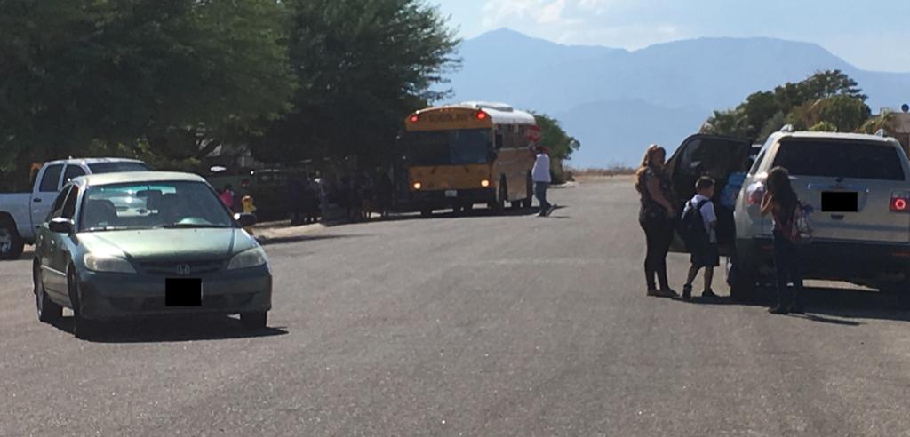
3 development of community-prioritized recommendations to inform active transportation efforts in North Shore. This report summarizes the workshop proceedings, as well as ideas identified during the process and recommendations for pedestrian and bicycle safety projects, policies, and programs. Background Community Pedestrian and Bicycle Safety Training Program The Community Pedestrian and Bicycle Safety Training (CPBST) program is a joint project of UC Berkeley SafeTREC and Cal Walks. Funding for this program is provided by a grant from the California Office of Traffic Safety (OTS) through the National Highway Traffic Safety Administration (NHTSA). The purpose of the CPBST program is to train local neighborhood residents and safety advocates on how to improve pedestrian and bicycle safety and to strengthen their collaboration with local officials and agency staff to make communities safer and more pleasant to walk and bike. For each training, the program convenes a multi-sector, multi-disciplinary local planning committee to tailor and refine the training s curriculum and focus to meet the community s needs. Additionally, Cal Walks staff conduct pre-training site visits to collect on-the-ground observations of existing walking and biking conditions to inform the training s scope and focus. The half-day training is designed to provide participants with both pedestrian and bicycle safety best practices and a range of proven strategies (the 6 E s: Empowerment & Equity, Evaluation, Engineering, Enforcement, Education, and Encouragement) to address and improve pedestrian and bicycle safety conditions and concerns. Participants are then guided on a walkability and bikeability assessment of nearby streets before setting pedestrian and bicycle safety priorities and actionable next steps for their community. For a summary of outcomes from past CPBST workshops, please visit: and Selected Pedestrian & Bicycle Safety Conditions in North Shore Lack of Sidewalks & Other Pedestrian Facilities With the exception of the immediate area surrounding Reyes Market, no sidewalks or crosswalk markings exist in the community of North Shore. Combined with the wide streets and lack of travel lane markings, the lack of sidewalks creates unsafe conditions for residents walking in the community, and in particular, for students walking to/from school bus stops distributed throughout the community. In an attempt to ensure the safe passage of their students, the Coachella Valley Unified School District requires its bus drivers to exit their buses with a hand-held stop sign to help manage traffic. However, this also poses a threat to the bus drivers as they often stand in the middle of the street while drivers maneuver around them. 2


4 Lack of sidewalks, street lighting, and lane markings, as well as blurring of street edge by sand. Bus driver required to direct traffic to help kids alight from school bus. 3

5 Lack of Street Lighting, Pedestrian-Scale Lighting, & Shade With the exception of the immediate area surrounding Reyes Market, no street lighting or pedestrianscale lighting exists in the community. The dark conditions make it very difficult for drivers to see anyone walking in the streets. Compounded by the lack of sidewalks, these conditions create a dangerous environment for pedestrians and bicyclists to share the roadway with vehicles. Additionally, the community has no shade trees or shade structures, which are especially needed in the hot summer months. The sole exception to this is a relatively new bus shelter in front of Reyes Market that provides some shade; yet this bus stop sits directly across from a completely unimproved bus stop. Unimproved bus stop lacking shade and lighting across from a newly installed bus shelter. Wide Streets & High Speeds Many streets in the community are very wide and lack lane or center divider markings. Many streets are straight and consequently, are conducive to drivers traveling at very high speeds. The wide streets and high speeds of drivers combined with the lack of sidewalks or other physical separation for people walking in the community result in dangerous conditions for residents, especially for students who travel in all directions when alighting from their school buses. 4


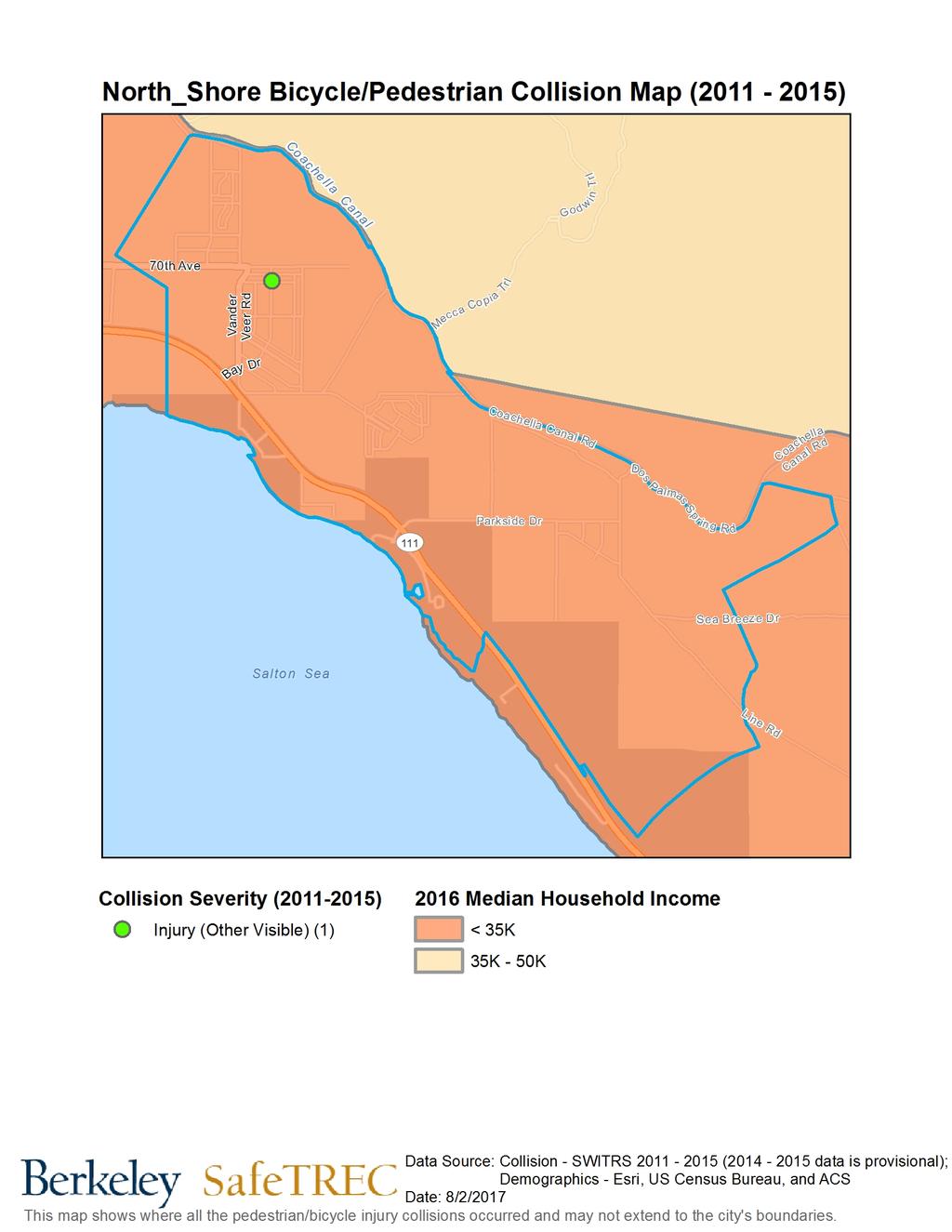
6 Wide streets with minimal pavement markings. Wide turn radii of streets can encourage drivers to make turns at high speeds. Wide streets with long straight sections often facilitate drivers to travel at high speeds in the community. Pedestrian & Bicycle Collision History Between , 1 there was 1 pedestrian collision and 2 bicycle collisions. Fortunately, none of these collisions resulted in fatalities or serious injuries. While this is a low number of collisions, the rate of collisions per 100,000 population for a community the size of North Shore is quite alarming. This situation is common in rural communities. To serve geographically and culturally diverse communities means that rate should be taken into consideration. A full discussion of the pedestrian and bicyclist collision data from official data sources prepared by UC Berkeley SafeTREC can be found Appendix A. Due to the community s remote location where law enforcement and emergency services response times have been reported by residents to take over one hour, there may be a number of unreported 1 Please note 2014 and 2015 data is provisional. 5

7 collisions in official data sources where a person in a collision might go directly to receive medical care. As part of the workshop, community members were asked to identify both overall traffic collisions that have occurred in the community that were not captured in the official data sources, as well as other safety concerns and barriers. Through this crowdsourcing exercise, community members identified an additional 5 traffic collisions not reflected in official data sources (Costa Mesa Drive and 69th Avenue; Sea View Way and 70th Avenue; Flamingo Drive and Miramar Drive; and Via Costa Brava and Miramar Drive), as well as one incident on Coral Reed Road and Harbor Drive where a pedestrian was killed by stray and aggressive pitbulls. Participants working on large-scale plotter maps to crowdsource collision and other safety data not reflected in official data sources. In terms of safety concerns and barriers, participants identified high speeds (particularly along 70th Avenue, Harbord Drive, 72nd Avenue, Rocky Point Drive, Vander Veer Road, and Mirarmar Drive); stray and aggressive dogs (especially on the east end of 70th Avenue and near 72nd Avenue and Windlass Drive); the lack of sidewalks near school and SunLine bus stops; off-road vehicle users traveling at high speeds on the weekends and during holidays; and the lack of street and pedestrian-scale lighting (particularly on Vander Veer Road, Seaside Avenue, and Costa Mesa Drive) as their primary safety concerns and barriers that prevent them from walking, biking, or taking transit more often. September 22, 2017 Workshop Leadership Counsel for Justice and Accountability requested a workshop to 1) provide County staff, community organizations, and residents with a toolkit for promoting pedestrian and bicycle safety to inform future active transportation projects; 2) strengthen working relationships between County and other regional agency staff, community organizations, residents, and other stakeholders to ensure the 6
![best outcomes for the residents of North Shore]; and 3) develop consensus regarding pedestrian and bicycle safety priority and actionable next steps that can help inform a regional mobility plan for](/docs-images/78/77190819/images/8-0.jpg "the unincorporated Eastern Coachella Valley communities, as well as to inform potential grant applications to the state s Active Transportation Program. Riverside County Supervisor V.")

8 best outcomes for the residents of North Shore]; and 3) develop consensus regarding pedestrian and bicycle safety priority and actionable next steps that can help inform a regional mobility plan for the unincorporated Eastern Coachella Valley communities, as well as to inform potential grant applications to the state s Active Transportation Program. Riverside County Supervisor V. Manuel Pérez providing opening remarks for the workshop. The workshop was hosted from 4:00 pm to 8:00 pm, and dinner and child watch were provided to maximize community participation. Additionally, the workshop was facilitated entirely in Spanish with simultaneous interpretation from Spanish to English to accommodate agency staff participants who do not speak Spanish. Forty (40) individuals attended the workshop, including community residents, Riverside County Supervisor V. Manuel Pérez, and representatives from Leadership Counsel for Justice and Accountability, SunLine Transit Agency, Kounkuey Design Initiative (KDI), Inland Congregations United for Change (ICUC), and Lideres Campesinas. Participants learning the 6 E s approach to pedestrian and bicycle safety 7

9 Reflections from Walkability & Bikeability Assessment & Community Resident Recommendations Workshop participants conducted walkability and bikeability assessments along 2 routes: Route 1 traveled from Miramar Drive to Dolphin Drive, then traveled down Dolphin Drive to Sea View Way, and finally returned to the workshop location via Lookout Drive. This Route focused on conditions along Miramar Drive, where a school bus stop and small community playground is located, as well as on conditions along Sea View Way, which residents noted felt dangerous to to drivers traveling at high speeds. Route 2 traveled from Miramar Drive down 70th Avenue to the intersection of 70th Avenue and Vander Veer Road. The focus of this route was to examine conditions along 70th Avenue and to compare and contrast conditions along 70th Avenue and other parts of the community to the improved conditions around Reyes Market. Participants discussing community conditions during the walk assessment. Participants were asked to 1) observe infrastructure conditions and the behavior of all road users; 2) apply strategies learned from the 6 E s presentation that could help overcome infrastructure concerns and unsafe driver, pedestrian, and bicyclist behavior; and 3) identify positive community assets and strategies which can be built upon. Following the walkability and bikeability assessment, the participants shared the following reflections and priorities for improvements to key routes where they currently walk, bike or take transit (in order of priority): Installation of Sidewalks at Key Locations: Participants underscored the need for sidewalks in the community to provide physical separation to residents and children walking to/from bus stops and other community destinations in North Shore. Participants identified installing sidewalks throughout North Shore as a top priority for improving safety for people walking. Residents prioritized sidewalk installation to connect the community to the planned North Shore Community Park; to connect residences to school bus stops and to SunLine bus stops; 8

10 and to connect residences with key community destinations such as Reyes Market and the playground on Miramar Drive. Installation of Lighting at Key Locations: Participants underscored the complete lack of street lighting throughout North Shore, and universally agreed that pedestrian-scale lighting should be prioritized for areas leading to school bus stops and SunLine bus stops. Participants noted that SunLine has historically refused to install bus shelters and lighting in areas with no sidewalk due to a concern about letting customers disembark safely, so residents feel caught in a bind where neither option offers safety. The playground on Miramar Drive also lacked any sort of lighting. Participants identified the installation of street lighting and pedestrian-scale lighting throughout North Shore as a top priority for improving safety for people walking and biking. Residents also prioritized the installation of pedestrian-scale lighting at the planned North Shore Community Park, at school bus stop locations, at SunLine bus stops, and at the community playground. Lack of lighting at community playground. Installation of High-Visibility Crosswalks: Residents strongly supported the installation of highvisibility crosswalks near key community destinations, particularly leading to the planned North Shore Community Park and at the Reyes Market intersection (Vander Veer Rd and 70th Avenue). Participants also identified the following locations for high-visibility crosswalks: Lookout Drive and Miramar Drive and 70th Avenue and Costa Mesa Drive. Regulating Off-Road Vehicle Users & Events: Residents also noted that people from outside the community come to North Shore to use their all-terrain vehicles (ATVs), off-road vehicles (OHV), and motocross vehicles, primarily on weekends and holidays. These users operate their vehicles at extremely high speeds on residential streets, jeopardizing the safety of North Shore residents and cause a great deal of noise pollution. Participants voiced strong support for the County to better regulate off-road vehicle users and events. Though residents did not identify specific measures, they are committed to work with the County to develop an appropriate and effective response. Desire for Transit Improvements: Participants underscored that many residents rely on SunLine buses for their transportation to access health care, school, and other essential social services. Residents expressed a strong desire for more frequent SunLine service to North Shore, as well 9

11 as to expand bus routes to serve the entire community. Participants also shared that they have experienced SunLine buses regularly failing to have ramps that can be deployed for riders who need them. Improved bus stop in front of Reyes market that residents would like to see in more locations throughout North Shore. Need to Address High Speeds: Residents repeatedly expressed concerns with drivers traveling at high speeds, particularly along Sea View Way, Costa Mesa Drive, 70th Avenue, Vander Veer Road, Bounty Avenue, and 72nd Avenue. Participants supported the installation of speed bumps and other traffic calming measures to slow drivers on 70th Avenue.Participants were asked to 1) observe infrastructure conditions and the behavior of all road users; 2) apply strategies learned from the 6 E s presentation that could help overcome infrastructure concerns and unsafe driver, pedestrian, and bicyclist behavior; and 3) identify positive community assets and strategies which can be built upon. 10

12 Off-road vehicle users observed during walk assessment. California Walks/SafeTREC Recommendations California Walks and SafeTREC also submit the following recommendations for consideration by the Riverside County Transportation Department, SunLine Transit Agency, and community groups: Train Residents to Conduct Additional Walk/Bike Assessments: Cal Walks and SafeTREC recommend that Leadership Counsel for Justice and Accountability and Kounkuey Design Initiative (KDI) who spearheaded the planning for this workshop work with Inland Congregations United for Change (ICUC) and Lideres Campesinas to train more residents to conduct additional walk/bike assessments. The community collection of qualitative data is critically important to better position North Shore to be competitive for grant opportunities. Specifically, we recommend working with residents to identify the key routes to school bus stops, SunLine bus stops, and the planned North Shore Community Park. Conducting walk/bike assessments along these routes to collect data should be coupled with photos to document existing conditions and safety concerns/barriers. Cal Walks has provided large-scale plotter maps of North Shore depicting designated school bus stops to assist in this effort and is able to offer follow-up technical assistance to community organizations if needed. Develop a Safe Routes to Transit Application to Active Transportation Program (ATP): With an anticipated call for projects for the state Active Transportation Program (ATP) slated for Spring 2018, we recommend that the Riverside County Transportation Department and SunLine Transit Agency work with community organizations and residents in Fall 2017/Winter 2018 to 11
13 begin developing a Safe Routes to Transit grant application that would fund many of the residents priorities, including the installation of sidewalks, pedestrian-scale lighting, and highvisibility crosswalk markings to school bus stops and to SunLine bus stops. Findings from community-led walk/bike assessments (as recommended above) can support the proposal and strengthen the grant application. Develop a Rural Safe Routes to School Program: Cal Walks and SafeTREC recommend that the Riverside County Department of Public Health partner with Leadership Counsel for Justice and Accountability as it begins its Safe Routes to School program for the Eastern Coachella Valley. Particularly if the Safe Routes to Transit project is awarded ATP funds, the Public Health Department can work with parents and residents to organize walking school buses to/from the school bus stops, as well as to/from the planned North Shore Community Park to encourage additional physical activity opportunities. Additional resources that may help include the Safe Routes to School National Partnership s Rural Communities: Best Practices and Promising Approaches for Safe Routes guide to help rural communities develop a SRTS program in light of their unique infrastructural and environmental obstacles. Investing time and resources in this programming now can help the community develop a program at the school anticipated to be built in North Shore in the coming years. Acknowledgments We would like to thank Rebecca Zaragoza (and her predecessor Mariela Magana) of Leadership Counsel for Justice and Accountability for inviting us to North Shore and to Maria ( Conchita ) Concepcion Pozar-Gonzalez for inviting us into her community and hosting the Community Pedestrian and Bicycle Safety Training in her home. We would also like to thank Juan Antonio Ramirez of Circulate San Diego for facilitating the training in Spanish. Lastly, we would like to acknowledge the many community members and agencies present at the workshop and their dedication to pedestrian and bicycle safety. Their collective participation meaningfully informed and strengthened the workshop s outcomes. Funding for this program was provided by a grant from the California Office of Traffic Safety through the National Highway Traffic Safety Administration. 12
14 Appendix A Pedestrian and Bicycle Collision Data Analysis
15 CPBST North Shore, CA September 22, 2017 Pedestrian and Bicycle Collision Analyses, * PEDESTRIANS Number of Collisions Involving Pedestrians, The blue line shows the number of pedestrian collisions where a fatality and/or injury occurred. There were 1 people injured or killed in 1 pedestrian collisions over the last 10 years. The green line shows the three-year moving average of the number of pedestrian collisions where a fatality and/or injury occurred. The moving average is useful for tracking trend change over time, especially when the number of collisions is subject to variability. Data points are the midpoint of the three years of data specified. The following analyses are based on the most current 10 years, 2006 to 2015, of data for North Shore, CA. In the last five years, , there were 0 people killed or injured in 0 pedestrian collisions. Top Violation Types for Collisions Involving Pedestrians, Type of Violation Collisions N(%) Unsafe Starting or Backing 1 (100%) Total 1 (100%) Pedestrian Actions in Collisions Involving Pedestrians, Pedestrian Action Collisions N(%) Not in Road 1 (100%) Total 1 (100.0%) This crash occurred on a Sunday in August between 6PM and 9PM. The lighting was dark with no streetlights. The crash occurred at 70 th Ave at Vander Veer Road. * Data Source: California Statewide Integrated Traffic Records System (SWITRS). Collision data for 2014 and 2015 are provisional at this time. Funding for this project was provided by a grant from the California Office of Traffic Safety through the National Highway Traffic Safety Administration.
16 CPBST North Shore, CA September 22, 2017 Pedestrian and Bicycle Collision Analyses, * Pedestrian Victim Demographics The age of the pedestrian victim ranged between 14 or younger. The victim was a male. 2 Number of Victims (n) (100%) 14 or younger 15 to to to to or older Victim Age Victim Injury Severity, The victim injury resulted in complaint of pain. Complaint of Pain 1 (100%) Male 1 (100%) * Data Source: California Statewide Integrated Traffic Records System (SWITRS). Collision data for 2014 and 2015 are provisional at this time. Funding for this project was provided by a grant from the California Office of Traffic Safety through the National Highway Traffic Safety Administration.
17 CPBST North Shore, CA September 22, 2017 Pedestrian and Bicycle Collision Analyses, * BICYCLISTS Number of Collisions Involving Bicyclists, The blue line shows the number of bicycle collisions where a fatality and/or injury occurred. There were 2 people killed or injured in 2 bicycle collisions over the last 10 years. The green line shows the threeyear moving average of the number of bicycle collisions where a fatality and/or injury occurred. The moving average is useful for tracking trend change over time, especially when the number of collisions is subject to variability. The following analyses are based on the most current 10 years, 2006 to 2015, of data for North Shore, CA. In the last five years, , there was 1 person killed or injured in 1 bicycle collision. Top Violation Types for Collisions Involving Bicycles Type of Violation Collisions N(%) Automobile Right of Way 1 (50%) Traffic Signals and Signs 1 (50%) Total 2 (100.0%) The two crashes occurred on Wednesday in May and Friday in June between 6PM and 9PM in daylight. One collision involved alcohol. The collisions occurred at Miramar Drive at Flamingo Drive and at 70 th Ave at Vander Veer Road. * Data Source: California Statewide Integrated Traffic Records System (SWITRS). Collision data for 2014 and 2015 are provisional at this time. Funding for this project was provided by a grant from the California Office of Traffic Safety through the National Highway Traffic Safety Administration.
18 CPBST North Shore, CA September 22, 2017 Pedestrian and Bicycle Collision Analyses, * Bicycling Victims Demographics The age of bicycling collision victims was concentrated among the youth, with youth age 14 or younger accounting for 100 percent of victims. Both victims were male. 3 Number of Victims (n) (100%) 0 14 or younger 15 to to to to or older Victim Age Victim Injury Severity, Most collisions resulted in other visible injuries. Other Visible Injury 2 (100%) Male * Data Source: California Statewide Integrated Traffic Records System (SWITRS). Collision data for 2014 and 2015 are provisional at this time. Funding for this project was provided by a grant from the California Office of Traffic Safety through the National Highway Traffic Safety Administration.
19 CPBST North Shore, CA September 22, 2017 Pedestrian and Bicycle Collision Analyses, * Pedestrian Collision Locations, * Data Source: California Statewide Integrated Traffic Records System (SWITRS). Collision data for 2014 and 2015 are provisional at this time. Funding for this project was provided by a grant from the California Office of Traffic Safety through the National Highway Traffic Safety Administration.
. Collision data for 2014 and 2015 are provisional at this time.")
20 CPBST North Shore, CA September 22, 2017 Pedestrian and Bicycle Collision Analyses, * Bicycle Collision Locations, * Data Source: California Statewide Integrated Traffic Records System (SWITRS). Collision data for 2014 and 2015 are provisional at this time. Funding for this project was provided by a grant from the California Office of Traffic Safety through the National Highway Traffic Safety Administration.
21
Recommendations to Improve Pedestrian & Bicycle Safety for the Missouri Flat Area (El Dorado County)
") Recommendations to Improve Pedestrian & Bicycle Safety for the Missouri Flat Area (El Dorado County) October 2017 Recommendations to Improve Pedestrian & Bicycle Safety for the Missouri Flat Area (El Dorado
Recommendations to Improve Pedestrian & Bicycle Safety for the Missouri Flat Area (El Dorado County) October 2017 Recommendations to Improve Pedestrian & Bicycle Safety for the Missouri Flat Area (El Dorado
Recommendations to Improve Pedestrian & Bicycle Safety in the Azusa Unified School District
 Recommendations to Improve Pedestrian & Bicycle Safety in the Azusa Unified School District October 2017 Recommendations to Improve Pedestrian & Bicycle Safety in the Azusa Unified School District By Mihaela
Recommendations to Improve Pedestrian & Bicycle Safety for the Community of Palermo
 Recommendations to Improve Pedestrian & Bicycle Safety for the Community of Palermo September 2017 Recommendations to Improve Pedestrian & Bicycle Safety for the Community of Palermo By Wendy Ortiz, Jaime
Recommendations to Improve Pedestrian & Bicycle Safety for the Community of Southwest Fresno
 Recommendations to Improve Pedestrian & Bicycle Safety for the Community of Southwest Fresno October 2017 Recommendations to Improve Pedestrian & Bicycle Safety for the Community of Southwest Fresno By
RECOMMENDATIONS TO IMPROVE PEDESTRIAN SAFETY IN MCKINLEYVILLE
 RECOMMENDATIONS TO IMPROVE PEDESTRIAN SAFETY IN MCKINLEYVILLE May 2015 By Tony Dang, Jaime Fearer, Wendy Alfsen, California Walks; Jill Cooper, UC Berkeley SafeTREC Recommendations to Improve Pedestrian
Recommendations to Improve Pedestrian & Bicycle Safety for the Arden-Arcade Community
 Recommendations to Improve Pedestrian & Bicycle Safety for the Arden-Arcade Community June 2018 Acknowledgements Planning Committee Joelle Orrock Gail Kelly Molly Patterson Dan Allison Heather Yee Molly
Recommendations to Improve Pedestrian & Bicycle Safety for the City of Arvin
 Recommendations to Improve Pedestrian & Bicycle Safety for the City of Arvin July 2018 1 Acknowledgements Planning Committee Jack Becker Tammy Fisher Pat Ebel Peter Smith Carlos Bello Christine Viterelli
RECOMMENDATIONS TO IMPROVE PEDESTRIAN & BICYCLIST SAFETY IN LOS ANGELES CHINATOWN
 RECOMMENDATIONS TO IMPROVE PEDESTRIAN & BICYCLIST SAFETY IN LOS ANGELES CHINATOWN October 2016 By Tony Dang, Caro Jauregui, Jaime Fearer, Wendy Alfsen, California Walks; Jill Cooper, Katherine Chen, UC
RECOMMENDATIONS TO IMPROVE PEDESTRIAN & BICYCLE SAFETY IN ROSEMONT
 RECOMMENDATIONS TO IMPROVE PEDESTRIAN & BICYCLE SAFETY IN ROSEMONT SEPT 2017 By Tony Dang, Jaime Fearer, Miha Tomuta, Wendy Ortiz, California Walks; Jill Cooper, Jessica Rosas, UC Berkeley SafeTREC Recommendations
RECOMMENDATIONS TO IMPROVE PEDESTRIAN & BICYCLE SAFETY IN THE COMMUNITY OF FLORENCE-FIRESTONE
 RECOMMENDATIONS TO IMPROVE PEDESTRIAN & BICYCLE SAFETY IN THE COMMUNITY OF FLORENCE-FIRESTONE September 2017 By Miha Tomuta, Wendy Ortiz, California Walks; Jill Cooper, Katherine Chen, UC Berkeley SafeTREC
RECOMMENDATIONS TO IMPROVE PEDESTRIAN & BICYCLIST SAFETY FOR THE MOUNTAIN VIEW SCHOOL DISTRICT (EL MONTE/SOUTH EL MONTE)
") RECOMMENDATIONS TO IMPROVE PEDESTRIAN & BICYCLIST SAFETY FOR THE MOUNTAIN VIEW SCHOOL DISTRICT (EL MONTE/SOUTH EL MONTE) August 2016 By Caro Jauregui, Jaime Fearer, Tony Dang, Wendy Alfsen California Walks;
RECOMMENDATIONS TO IMPROVE PEDESTRIAN & BICYCLIST SAFETY FOR THE MOUNTAIN VIEW SCHOOL DISTRICT (EL MONTE/SOUTH EL MONTE) August 2016 By Caro Jauregui, Jaime Fearer, Tony Dang, Wendy Alfsen California Walks;
Recommendations to Improve Pedestrian & Bicycle Safety for the City of Bakersfield
 Recommendations to Improve Pedestrian & Bicycle Safety for the City of Bakersfield August 2018 1 Acknowledgements Planning Committee Jack Becker Bike Bakersfield Cindy Parra Bike Bakersfield Christopher
Recommendations to Improve Pedestrian & Bicycle Safety for the Zane Middle School Community
 Recommendations to Improve Pedestrian & Bicycle Safety for the Zane Middle School Community October 2018 1 Acknowledgements Planning Committee Nicole Sager Jesse Willor Jenny Weiss Emily Sinkhorn Scott
PEDESTRIAN ACTION PLAN
 ATTACHMENT 2 CITY OF SANTA MONICA PEDESTRIAN ACTION PLAN CITY OF SANTA MONICA PEDESTRIAN ACTION PLAN This page intentionally left blank EXECUTIVE SUMMARY CHAPTER 1 EXECUTIVE SUMMARY Setting the Stage
Recommendations to Improve Pedestrian & Bicycle Safety for the Clegg Elementary School & Stacey Middle School Community
 Recommendations to Improve Pedestrian & Bicycle Safety for the Clegg Elementary School & Stacey Middle School Community (Westminster School District) October 2018 1 Acknowledgements Planning Committee
Recommendations to Improve Pedestrian & Bicycle Safety for the City of Hayward: Tennyson Road Corridor
 Recommendations to Improve Pedestrian & Bicycle Safety for the City of Hayward: Tennyson Road Corridor October 2018 1 Acknowledgments Planning Committee Charmine Solla Steven Chang Patty Garcia Sergio
City of San Diego Vision Zero Draft Strategic Plan FY 2017
 City of San Diego Vision Zero Draft Strategic Plan FY 2017 Engineering Objective: To develop and implement a strategy that employs best planning, design and engineering practices. Background: Over the
Chapter 14 PARLIER RELATIONSHIP TO CITY PLANS AND POLICIES. Recommendations to Improve Pedestrian Safety in the City of Parlier (2014)
") Chapter 14 PARLIER This chapter describes the current status and future plans for biking and walking in the City of Parlier. RELATIONSHIP TO CITY PLANS AND POLICIES The Parlier General Plan is the primary
Chapter 14 PARLIER This chapter describes the current status and future plans for biking and walking in the City of Parlier. RELATIONSHIP TO CITY PLANS AND POLICIES The Parlier General Plan is the primary
Recommendations to Improve Pedestrian & Bicycle Safety for the Valley West Community in Arcata
 Recommendations to Improve Pedestrian & Bicycle Safety for the Valley West Community in Arcata October 2018 1 Acknowledgements Planning Committee Netra Khatri Julie Neander Emily Sinkhorn Jennifer Weiss
COMMUNITY PEDESTRAIN SAFETY TRAINING. Santa Ana June 27 th 2009
 COMMUNITY PEDESTRAIN SAFETY TRAINING Santa Ana June 27 th 2009 Santa Ana Santa Ana is the heart of Orange County located in Southern California. The estimated population of Santa Ana is 339,130 in 2008,
Bringing together community and health. Physical Activity and Nutrition Unit Office of Statewide Health Improvement Initiatives
 Bringing together community and health. Physical Activity and Nutrition Unit Office of Statewide Health Improvement Initiatives Physical Activity and Nutrition Unit Office of Statewide Health Improvement
Recommendations to Improve Pedestrian & Bicycle Safety for the City of Lemon Grove
 Recommendations to Improve Pedestrian & Bicycle Safety for the City of Lemon Grove October 2018 1 Acknowledgements Planning Committee Anita Lopez Rosa Carney Steve Browne Angeles Nelson Lemon Grove Healthy
May 12, 2016 Metro Potential Ballot Measure Issue Brief: Local Return
 Summary: Local return is an important revenue source for cities to maintain their local transportation infrastructure. Most cities use their local return to operate small bus systems and repave streets,
City of Novi Non-Motorized Master Plan 2011 Executive Summary
 City of Novi Non-Motorized Master Plan 2011 Executive Summary Prepared by: February 28, 2011 Why Plan? Encouraging healthy, active lifestyles through pathway and sidewalk connectivity has been a focus
Bikeway action plan. Bicycle Friendly Community Workshop March 5, 2007 Rochester, MN
 Bikeway action plan Summary The was held on March 5, 2007 at the Rochester Mayo Civic Center. The workshop was hosted by Rochester-Olmsted County Planning Department in collaboration with the League of
The Miami-Dade Safe Routes to School Initiative
 The Miami-Dade Safe Routes to School Initiative Perla Tabares Hantman School Board Chair Miami-Dade County Public Schools & Governing Board Member of the Miami-Dade Metropolitan Planning Organization August
Bicycle Master Plan Goals, Strategies, and Policies
 Bicycle Master Plan Goals, Strategies, and Policies Mobilizing 5 This chapter outlines the overarching goals, action statements, and action items Long Beach will take in order to achieve its vision of
Pedestrian injuries in San Francisco: distribution, causes, and solutions
 Pedestrian injuries in San Francisco: distribution, causes, and solutions Presentation to the San Francisco Health Commission RAJIV BHATIA, MD, MPH DIRECTOR OF OCCUPATIONAL AND ENVIRONMENTAL HEALTH, SAN
COMMUNITY PEDESTRAIN SAFETY TRAINING. Long Beach June 5 th, 2010
 COMMUNITY PEDESTRAIN SAFETY TRAINING Long Beach June 5 th, 2010 Long Beach The City of Long Beach is located in Los Angeles County, Southern California. Long Beach is currently home to 462,604 persons
APPENDIX A. Outreach Summary
 APPENDIX A Outreach Summary COUNTYWIDE TRANSPORTATION PLAN Summary of Public Outreach and Engagement To gather an understanding of the transportation issues and priorities throughout the county, and inform
NM-POLICY 1: Improve service levels, participation, and options for non-motorized transportation modes throughout the County.
 Transportation PRINCE WILLIAM COUNTY 2008 COMPREHENSIVE PLAN NON-MOTORIZED PLAN CONTENTS Goals, Policies, and Action Strategies Table 4 (Bike Facility Classifications and Descriptions) Table 5 (Bike Facility
Vallecito Elementary School. Travel Plan
 Vallecito Elementary School Travel Plan TABLE OF CONTENTS 1. PURPOSE... 1 1.1. SR2S PLANNING, IMPLEMENTATION AND MONITORING... 1 1.2. MARIN COUNTY MEASURE A... 1 2. VALLECITO ELEMENTARY SCHOOL PROFILE...
5. Pedestrian System. Accomplishments Over the Past Five Years
 5. Pedestrian System Accomplishments Over the Past Five Years The Alamo Area Metropolitan Planning Organization (MPO) and its partner agencies recognize the importance of improving pedestrian mobility.
SAFE ROUTES TO SCHOOL (SR2S)
") SAFE ROUTES TO SCHOOL (SR2S) In partnership with Burbank Unified School District (BUSD) & City of Burbank George Washington Elementary School Thomas Jefferson Elementary School John Muir Middle School
SAFE ROUTES TO SCHOOL (SR2S) In partnership with Burbank Unified School District (BUSD) & City of Burbank George Washington Elementary School Thomas Jefferson Elementary School John Muir Middle School
CONNECTING PEOPLE TO PLACES
 CONNECTING PEOPLE TO PLACES 82 EAST BENCH MASTER PLAN 07 Introduction The East Bench transportation system is a collection of slow moving, treelined residential streets and major arteries that are the
DRAFT MOVING FORWARD RHODE ISLAND BICYCLE MOBILITY PLAN 2018 PREPARED FOR PREPARED BY IN ASSOCIATION WITH
 RHODE ISLAND MOVING FORWARD BICYCLE MOBILITY PLAN 2018 PREPARED FOR PREPARED BY IN ASSOCIATION WITH T AF CHAPTER 1 D R INTRODUCTION CHAPTER 3 ARTICULATES VISION Bicycling is safe, fun and practical in
CITY OF BLOOMINGTON COMPLETE STREETS POLICY
 CITY OF BLOOMINGTON COMPLETE STREETS POLICY POLICY OBJECTIVE: The City of Bloomington will enhance safety, mobility, accessibility and convenience for transportation network users of all ages and abilities,
RECOMMENDATIONS TO IMPROVE PEDESTRIAN & BICYCLIST SAFETY IN THE CITY OF SHASTA LAKE
 RECOMMENDATIONS TO IMPROVE PEDESTRIAN & BICYCLIST SAFETY IN THE CITY OF SHASTA LAKE October 2016 By Tony Dang, Jaime Fearer, Wendy Alfsen, California Walks; Jill Cooper, Jesus Barajas, UC Berkeley SafeTREC
8. Collisions INTRODUCTION
 8. Collisions INTRODUCTION While traffic collisions can affect anyone, they have a disproportionate impact on bicyclists, who along with pedestrians are the most vulnerable users of the transportation
Toward Zero Deaths. Regional SHSP Road Show Meeting. Virginia Strategic Highway Safety Plan. presented by
 Toward Zero Deaths Regional SHSP Road Show Meeting presented by Virginia Strategic Highway Safety Plan December 1, 2016 1 Welcome & Introductions Purpose of the Meeting Objectives & Key Outcomes Agenda»
FINAL PLAN APPENDIX D CITY OF BERKELEY BIKE PLAN D-1
 CITY OF BERKELEY BIKE PLAN D-1 . Proposed Programs D.1. EDUCATION This appendix presents the recommended bicycle-related programs for the City of Berkeley. The recommendations are organized in four E s:
SPEED MANAGEMENT FOR VISION ZERO
 SPEED MANAGEMENT FOR VISION ZERO LUANN HAMILTON, DEPUTY COMMISSIONER FOR PROJECT DEVELOPMENT CHICAGO DEPARTMENT OF TRANSPORTATION NACTO DESIGNING CITIES 2017 Vision Zero Action Plan Speed management and
MASTER BICYCLE AND PEDESTRIAN PLAN
 VILLAGE OF NORTHBROOK MASTER BICYCLE AND PEDESTRIAN PLAN DRAFT PLAN OPEN HOUSE May 2, 2018 AGENDA 1. Community Engagement 2. Vision and Goals 3. General Structure of Plan 4. Recommendations Overview 5.
Living Streets Policy
 Living Streets Policy Introduction Living streets balance the needs of motorists, bicyclists, pedestrians and transit riders in ways that promote safety and convenience, enhance community identity, create
Cherry Creek Transportation and Land Use Forum September 25, 2013 Meeting Summary
 Cherry Creek Transportation and Land Use Forum September 25, 2013 Meeting Summary I. LEAD-IN TO SMALL GROUP DISCUSSION, POLLING AND STEERING COMMITTEE/TECHNICAL TASK FORCE DISCUSSION The meeting began
TABLE OF CONTENTS. Executive Summary
 Executive Summary Background... ES-1 Pedestrian Network... ES-2 Bikeway Network... ES-2 Collision History... ES-2 Public Input... ES-4 Conclusions and Recommendations... ES-4 1. Introduction and Setting
Lawrence Safe Routes to School. Community Meeting January 14, 2015
 Lawrence Safe Routes to School Community Meeting January 14, 2015 Safe Routes to School The 6 E s Education Encouragement Enforcement Engineering Evaluation Equity What are the elements of a SRTS plan?
RECOMMENDATIONS TO IMPROVE PEDESTRIAN & BICYCLIST SAFETY IN MODESTO S AIRPORT NEIGHBORHOOD
 RECOMMENDATIONS TO IMPROVE PEDESTRIAN & BICYCLIST SAFETY IN MODESTO S AIRPORT NEIGHBORHOOD August 2016 By Jaime Fearer, Caro Jauregui, Tony Dang, Wendy Alfsen, California Walks; Jill Cooper, UC Berkeley
Item 7 Enclosure Citizens Advisory Committee March 27, 2013 San Francisco Safe Routes to School Program
 Item 7 Enclosure Citizens Advisory Committee March 27, 2013 1 San Francisco Safe Routes to School Program Ana Validzic, MPH SF Department of Public Health 2 Safe Routes to School Program Need Fewer kids
SAFE ROUTES TO SCHOOL
 SAFE ROUTES TO SCHOOL Forest Ridge Elementary School Existing Conditions and ACTION PLAN > Oak Creek - Franklin Joint School District Table of Contents CONTEXT Enrollment Boundaries
POLICY AGENDA For Elder Pedestrian Safety
 POLICY AGENDA For Elder Pedestrian Safety Older adults and people with disabilities often have mobility, cognitive, and sensory limitations that affect their behavior as pedestrians and place them at risk
Perryville TOD and Greenway Plan
 Perryville TOD and Greenway Plan Greenway Glossary Pathway: A bicycle and pedestrian path separated from motorized vehicular traffic by an open space, barrier or curb. Multi-use paths may be within the
Defining Purpose and Need
 Advanced Design Flexibility Pilot Workshop Session 4 Jack Broz, PE, HR Green May 5-6, 2010 Defining Purpose and Need In your agency s project development process, when do design engineers typically get
ABOUT THIS STUDY The Tenderloin-Little Saigon Community-Based Transportation Plan
 ABOUT THIS STUDY The Tenderloin-Little Saigon Community-Based Transportation Plan The Greater Tenderloin Community Study Milestones October Community based organizations (Tenderloin Housing Clinic and
AMENDING MOTION: Mobility Plan - Pedestrians and Disadvantaged Communities
 I MOVE that the Council: AMENDING MOTION: Mobility Plan - Pedestrians and Disadvantaged Communities 1. INSTRUCT the Department of City Planning to amend the proposed Mobility Plan to include the following;
Summary Report School Walking & Bicycling Audits. Mesa County Regional Transportation Planning Office
 Summary Report School Walking & Bicycling Audits Mesa County Regional Transportation Planning Office This page left blank intentionally WALKING & BICYCLING AUDIT SUMMARY 2 Executive Summary Background:
Chapter 13 ORANGE COVE
 Chapter 13 ORANGE COVE This chapter describes the current status and future plans for biking and walking in the City of Orange Cove. RELATIONSHIP TO CITY PLANS AND POLICIES The Orange Cove General Plan
Bike Flemingdon Park and Thorncliffe Park Public Consultation Report
 Bike Flemingdon Park and Thorncliffe Park Public Consultation Report January 2018 Prepared by: Robyn Shyllit Senior Public Consultation Coordinator Public Consultation Unit, City of Toronto Contents Executive
CITY OF LOS ANGELES INTER-DEPARTMENTAL MEMORANDUM
 CITY OF LOS ANGELES INTER-DEPARTMENTAL MEMORANDUM Date: December 12,2011 To: Honorable City Council c/o City Clerk, Room 395, City Hall Attention: Honorable Bill Rosendahl, Chair, Transportation Committee
The Florida Bicycle and Pedestrian Partnership Council
 The Florida Bicycle and Pedestrian Partnership Council Input to the Update of the Florida Transportation Plan March 2015 This document presents input from the Florida Bicycle and Pedestrian Advisory Council
This page intentionally left blank.
 This page intentionally left blank. COMMUNITY Coweta Community Overview Coweta Coweta, a residential community located in Wagoner County, is a suburb of Tulsa situated southeast of the metropolitan area
CITY OF OAK CREEK SAFE ROUTES TO SCHOOL ACTION PLAN. East Middle School
 CITY OF OAK CREEK SAFE ROUTES TO SCHOOL ACTION PLAN East Middle School CITY OF OAK CREEK SAFE ROUTES TO SCHOOL ACTION PLAN East Middle School Why Safe Routes to School? Safe Routes to School ( SRTS ) is
Traffic Safety Barriers to Walking and Bicycling Analysis of CA Add-On Responses to the 2009 NHTS
 Traffic Safety Barriers to Walking and Bicycling Analysis of CA Add-On Responses to the 2009 NHTS NHTS Users Conference June 2011 Robert Schneider, Swati Pande, & John Bigham, University of California
Safe and Active Routes to School in Cabarrus County
 Safe and Active Routes to School in Cabarrus County In 2014, Cabarrus Health Alliance became the host agency for the Charlotte region s coordinator in the NC Active Routes to School program. The NC-ARTS
San Bernardino County Non-Motorized Transportation Plan - Chapter 5
 City of Yucaipa Population 51,476 City Overview Yucaipa is located in the eastern portion of the San Bernardino Valley area, at the foot of the San Bernardino Mountains, between the Cities of Redlands
Welcome! San Jose Avenue Open House August 25, 2015
 Welcome! San Jose Avenue Open House August 25, 2015 Vision Zero The City and County of San Francisco adopted Vision Zero San Francisco Vision Zero High Injury Network as a policy in 2014, committing an
Focus on Enforcement. 3/14/2017 Presentation to the Vision Zero Taskforce. Joe Lapka Corina Monzón
 Focus on Enforcement Insights from research and analysis in support of San Francisco s Vision Zero plan to eliminate traffic deaths Joe Lapka Corina Monzón 3/14/2017 Presentation to the Vision Zero Taskforce
Focus on Enforcement. 7/21/2017 Presentation to SFMTA Policy & Governance Committee. Joe Lapka Corina Monzón
 Focus on Enforcement Insights from research and analysis in support of San Francisco s Vision Zero plan to eliminate traffic deaths Joe Lapka Corina Monzón 7/21/2017 Presentation to SFMTA Policy & Governance
COWETA HIGH SCHOOL AND EAST HIGHWAY 51
 COWETA HIGH SCHOOL AND EAST HIGHWAY 51 Lack of sidewalks along Ben Lumpkin Rd. Lack of crosswalks and ramps at intersection. Hwy 51 is wide to cross as a pedestrian. No ADA compliance or connection to
Pedestrian Safety Workshop SAN FRANCISCO, CALIFORNIA
 Pedestrian Safety Workshop 02 15 2011 SAN FRANCISCO, CALIFORNIA 1 Agenda Walking in San Francisco Accomplishments and Current Pedestrian Activities Mayor s Pedestrian Safety Executive Directive Next Steps
Vision Zero Task Force February 28, Collision Landscape Analysis
 Vision Zero Task Force February 28, 2017 Collision Landscape Analysis Welcome! What happened since our last Task Force meeting: City Council adopted the Vision Zero Resolution Applied for an OTS grant
Agenda. Overview PRINCE GEORGE S PLAZA METRO AREA PEDESTRIAN PLAN
 PRINCE GEORGE S PLAZA METRO AREA PEDESTRIAN PLAN May 28, 2008 Agenda Welcome and introductions Project overview and issue identification Planning context and strengths Design challenges and initial recommendations
TOWN OF PORTLAND, CONNECTICUT COMPLETE STREETS POLICY
 TOWN OF PORTLAND, CONNECTICUT COMPLETE STREETS POLICY I. VISION, GOALS & PRINCIPLES VISION To improve the streets of Portland making them safer and more accessible for all users including pedestrians,
PRINCE GEORGE S PLAZA METRO AREA PEDESTRIAN PLAN
 PRINCE GEORGE S PLAZA METRO AREA PEDESTRIAN PLAN May 28, 2008 Agenda Welcome and introductions Project overview and issue identification Planning context and strengths Design challenges and initial recommendations
SAN FRANCISCO MUNICIPAL TRANSPORTATION AGENCY
 THIS PRINT COVERS CALENDAR ITEM NO. : 10.2 DIVISION: Sustainable Streets BRIEF DESCRIPTION: SAN FRANCISCO MUNICIPAL TRANSPORTATION AGENCY Adopting Conceptual Proposal for Streetscape Improvements to Broadway,
Appendix C 3. Bicycle / Pedestrian Planning
 Appendix C 3. Bicycle / Pedestrian Planning BICYCLE/PEDESTRIAN PLANNING 2005 Master Plan GOAL: Provide for safe and convenient bicycle and pedestrian circulation throughout the City. Develop a city-wide
Lisa Quinn Executive Director
 Transforming Injury and Violence Prevention: Innovations in Policy, Practice, and Partnerships Advocating for Prevention: Enacting and Reacting to Legislation Lisa Quinn Executive Director Feet First works
NYC Pedestrian Safety Study & Action Plan. NYTMC Brown Bag Lunch Presentation December 15, 2010
 NYC Pedestrian Safety Study & Action Plan NYTMC Brown Bag Lunch Presentation December 15, 2010 1 Introduction DOT Safety Goal Strategic Plan: Reduce Fatalities by 50% by 2030 From 274 (2007) to 137 (2030)
CHAPTER 3: Vision Statement and Goals
 Davidson Walks & Rolls: Active Transportation Master Plan CHAPTER 3 Contents: Overview Vision Statement Measurable Goals Public Outreach CHAPTER 3: Vision Statement and Goals Overview The vision statement
RESOLUTION NO ?? A RESOLUTION OF THE CITY OF NEPTUNE BEACH ADOPTING A COMPLETE STREETS POLICY
 RESOLUTION NO. 2018-?? A RESOLUTION OF THE CITY OF NEPTUNE BEACH ADOPTING A COMPLETE STREETS POLICY WHEREAS, safe, convenient, and accessible transportation for all users is a priority of the City of Neptune
Safety and Active Transport. Dr. Maureen Carew, Medical Officer of Health Renfrew County and District Health Unit May 30, 2014
 Safety and Active Transport Dr. Maureen Carew, Medical Officer of Health Renfrew County and District Health Unit May 30, 2014 Active Transport Vision Increase levels of walking and cycling Reduce vehicle
Pedestrian Safety Initiatives National Highway Traffic Safety Administration (NHTSA)
") Pedestrian Safety Initiatives National Highway Traffic Safety Administration (NHTSA) Report to the Transportation Research Board Pedestrian Safety Committee January 2010 Leah Walton Safety Countermeasures
Pedestrian Safety Initiatives National Highway Traffic Safety Administration (NHTSA) Report to the Transportation Research Board Pedestrian Safety Committee January 2010 Leah Walton Safety Countermeasures
Department of Transportation
 Department of Transportation I. Internal Scan The number of older drivers in the United States will double over the next 30 years. By 2030 one in five Americans will be age 65 or older. On a licensed-driver
POLICY STATEMENT: VISION ZERO
 Overview of APBP Policy Statements POLICY STATEMENT: VISION ZERO The Association of Pedestrian and Bicycle Professionals (APBP) supports the community of professionals working to create more walkable,
7/23/2017 VIA . Michael Hanebutt City of Sacramento Community Development Department 300 Richards Boulevard, 3 rd Floor Sacramento, CA 95811
 7/23/2017 VIA EMAIL Michael Hanebutt City of Sacramento Community Development Department 300 Richards Boulevard, 3 rd Floor Sacramento, CA 95811 RE: 65 th Street Apartments (DR17-220) Dear Mr. Hanebutt:
University-Community Partnerships for Environmental Justice: An example from the San Fernando Valley
 University-Community Partnerships for Environmental Justice: An example from the San Fernando Valley Zeynep Toker, Ph.D., Associate Professor, Urban Studies and Planning Department, California State University,
CONTRA COSTA. Countywide Bicycle and Pedestrian Plan. Executive Summary. July Contra Costa Countywide Bicycle & Pedestrian Plan
 CONTRA COSTA Countywide Bicycle and Pedestrian Plan Executive Summary July 2018 i The preparation of this report has been financed through a grant from the U.S. Department of Transportation and the Federal
USDOT Bicycle and Pedestrian Safety Initiative: Safer People and Safer Streets. Barbara McCann, USDOT Office of Policy
 { USDOT Bicycle and Pedestrian Safety Initiative: Safer People and Safer Streets Barbara McCann, USDOT Office of Policy 4 Steps from policy to practice Creating multi-modal streets means: 1. Change Decision-Making
TULARE COUNTY ASSOCIATION OF GOVERNMENTS
 TULARE COUNTY ASSOCIATION OF GOVERNMENTS Workshop: Creating Bikeable, Walkable Communities Wednesday, June 7, 2017 REVIEW OF THE 2016 REGIONAL ACTIVE TRANSPORTATION PLAN TCAG - 559-623-0450 210 N. Church
AGENDA ITEM NO. 5b HCAOG TAC meeting of May 8, 2014
 Humboldt County Association of Governments Eureka, CA, 95501 AGENDA ITEM NO. 5b HCAOG TAC meeting of May 8, 2014 DATE: May 1, 2014 TO: HCAOG Technical Advisory Committee (TAC) FROM:, SUBJECT: Letters of
How to Develop a Pedestrian Safety Action Plan
 How to Develop a Pedestrian Safety Action Plan Course Introduction Presented by: Peter Eun FHWA RC Safety Engineer Ryan Snyder President, Ryan Snyder Associates, LLC Paul Zykofsky Director, Land Use and
West Capitol Avenue Road Rehabilitation and Safety Enhancement Project
 West Capitol Avenue Road Rehabilitation and Safety Enhancement Project Stakeholder Focus Group Meeting #2 Tuesday, August 28, 2018 7:00 8:00 a.m. West Sacramento City Hall 1110 West Capitol Avenue, West
April 30 th, Reducing the Risks to Child Pedestrians
 April 30 th, 2018 Reducing the Risks to Child Pedestrians Technical Tips Audio is broadcast through computer speakers Download resources in the File Share pod (above the slides) If you experience audio
FHWA Resources for Pedestrian and Bicycle Professionals
 FHWA Resources for Pedestrian and Bicycle Professionals Charlie Zegeer, UNC Highway Safety Research Center/PBIC Libby Thomas, UNC Highway Safety Research Center Dan Nabors, Vanasse Hangen Brustlin (VHB)
Chapter 2: Standards for Access, Non-Motorized, and Transit
 Standards for Access, Non-Motorized, and Transit Chapter 2: Standards for Access, Non-Motorized, and Transit The Washtenaw County Access Management Plan was developed based on the analysis of existing
City of Charlottesville Bicycle and Pedestrian Master Plan Update
 City of Charlottesville Bicycle and Pedestrian Master Plan Update September 17, 2014 I. Welcome and meeting overview II. Project status update III. Network overview IV. Break-out groups Pedestrian Network
We believe the following comments and suggestions can help the department meet those goals.
 The Honorable Secretary Anthony Foxx The Secretary of Transportation United States Department of Transportation 1200 New Jersey Avenue, SE Washington, DC 20590 August 30, 2013 Dear Secretary Foxx, Thank
MnDOT Implementation of Complete Streets Policy. January 2014
 MnDOT Implementation of Complete Streets Policy January 2014 1 Prepared by Minnesota Department of Transportation 395 John Ireland Boulevard Saint Paul, Minnesota 55155-1899 Phone: 651-296-3000 Toll-Free:
Sistrunk Corridor DOTMOCRACY SUMMARY
 DOTMOCRACY SUMMARY The TOUCH initiative is a true collaborative working with multi- sector community organizations and agencies to reduce tobacco use and exposure to secondhand smoke, improve access to
WELCOME Mission-Geneva Transportation Study
 WELCOME Mission-Geneva Transportation Study Study Process and Schedule 2005 2006 Oct Nov Dec Jan Feb Mar Apr May Jun Jul Aug Sept Oct Task 2 Develop Outreach Plan Task 3 Document Existing Conditions/ Prioritize