NY Route 5 Comprehensive Pedestrian Safety Study: A Corridor Perspective CDTC Planning Committee. January 7, 2015
|
|
|
- Shanna Lane
- 6 years ago
- Views:
Transcription

1 NY Route 5 Comprehensive Pedestrian Safety Study: A Corridor Perspective CDTC Planning Committee January 7, 2015

2 Project Objective Study Scope: Perform an analysis of pedestrian related accidents, An engineering assessment of existing infrastructure related to pedestrian safety. Develop planning level recommendations that, upon implementation, will help to improve pedestrian safety along this highly traveled corridor. Form a comprehensive pedestrian safety plan for the Route 5 corridor through a combination of the Three E s : Education Enforcement Engineering The data collection, analysis, and suggested countermeasures were conducted and developed to support the Education, Enforcement, and Engineering components of the study.


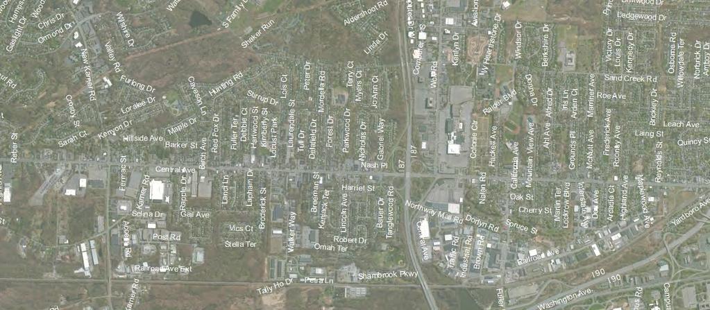
3 Study Area 15.4 Mile Segment of Route 5 Washington Avenue in Schenectady to Broadway in Albany Schenectady Segment 4 miles NYSDOT Segment 7.6 Miles» Town of Niskayuna» Town of Colonie» Village of Colonie Albany Segment 3.8 Miles


4 Study Area 81 signalized intersections City of Schenectady Segment» 29 Signalized Intersections NYSDOT Segment» 20 Signalized Intersections City of Albany Segment» 32 Signalized Intersections
 47 of the 81 signalized intersections represented Findings can be applied through corridor")
5 Study Area Scoping Process Study area divided into Eight Focus Areas» 2 Schenectady» 3 Colonie» 3 Albany 206 of the 290 pedestrian accidents represented (6 years of data) 47 of the 81 signalized intersections represented Findings can be applied through corridor
 15 signalized intersections, 1 pedestrian")
 Bicycle Accidents (acting as a pedestrian)")
6 Study Area Schenectady Segment Focus Area 1 (Washington Ave Nott Terrace/Veeder Ave) Focus Area 2 (Swan St Fehr Ave/Elbert St) 15 signalized intersections, 1 pedestrian only signal Daily Traffic Volume = 9,600 to 15,900 cars per day Vehicular Accidents = 1,005 Pedestrian Accidents = 44 (1 Fatality) Bicycle Accidents (acting as a pedestrian) =
 Focus Area 4 (Shoprite/Willow Ave Nicholas Drive/Woolard")

 Bicycle Accidents (acting")
7 Study Area NYSDOT Segment Focus Area 3 (Midway Fire Dept. Vly Road) Focus Area 4 (Shoprite/Willow Ave Nicholas Drive/Woolard Ave) Focus Area 5 (Wolf Road Osborne Road) 14 signalized intersections, 1 pedestrian only/fire signal Daily Traffic Volume = 25,500 to 43,250 cars per day Vehicular Accidents = 1,390 Pedestrian Accidents = 55 (5 Fatalities) Bicycle Accidents (acting as a pedestrian) =
 Focus Area")
 15 signalized")


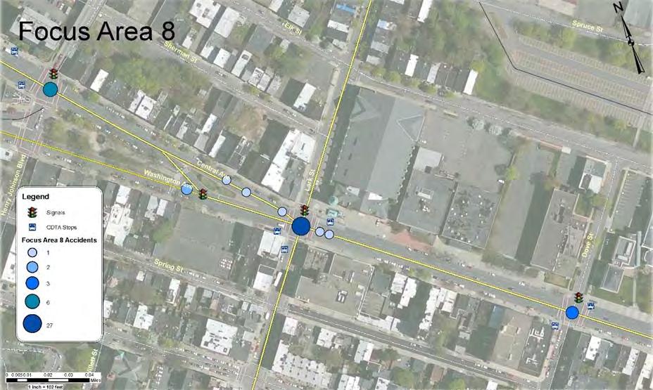
8 Study Area Albany Segment Focus Area 6 (Colvin Ave North Allen St/Watervliet Ave) Focus Area 7 (Partridge St Robin St) Focus Area 8 (Henry Johnson Blvd Dove St) 15 signalized intersections, 1 pedestrian only signal Daily Traffic Volume = 16,675 to 28,800 cars per day Vehicular Accidents = 1,761 Pedestrian Accidents = 107 Bicycle Accidents (acting as a pedestrian) =

")
9 Engineering Recent Improvements Upgrades in 2013/2014: Leading pedestrian intervals added to various signals New elevator style pedestrian buttons Other recent upgrades independent of study: Median barrier installed on Washington Ave Streetscape/Traffic Calming projects Erie Blvd to Nott Terrace/Veeder Avenue Kelton Avenue to Fehr Avenue Erie Boulevard reconstruction project New traffic signals Willow Avenue/ShopRite OTB/ShopRite ADA improvements to pedestrian push buttons, signs, ramps CDTA bus rapid transit stations, TSP and QJ features Included some pedestrian upgrades (i.e., Jupiter Lane)

10 Project Complexities Municipal/Agency Coordination NYSDOT Cities of Schenectady and Albany Towns of Colonie and Niskayuna Village of Colonie 22 meetings in approximately 6 months CDTA Considerations including BusPlus Highest CDTA Ridership in Capital District with 3.9 million riders per year Traffic signal coordination throughout the corridor Extensive field work component
11 Project Overview Planning Level Study Existing Conditions Assessment Pedestrian Accident Analysis» Review of bicycle accidents Provisions for Pedestrians» Crosswalks» Pedestrian push buttons» Signs» Pedestrian phasing at signals Pedestrian Counts and Traffic Volumes» Peak Hour Counts and Off Peak Counts (10 locations)» Document use of Equipment Roadway Geometry» Lane widths and lane use» Pavement markings» Parking regulations Traffic Signal timing and operations Street lighting Transit

12 Overall Accident Review
 Vehicle Only 1 3,315 21 1 7 386 2 1,960 22 0 6 619 3 400 16 2 2 325 4 235 14 1 10 450 5 710 20 2 15 615 6 1,270 21 0 8 880 7 3,390 43 0 11 528 8 3,465 43 0 2 353 Total 14,745 200")
13 Overall Accident Review Focus Area Pedestrians (Total 4 Hour Count) Six Year Crash History (January 2007 to December 2012) Pedestrian Injury Pedestrian Fatality Bicycle (acting as pedestrian) Vehicle Only 1 3, , , , , Total 14, ,156
14 Observed Behavior Using Ped. Phase Focus Area Total Pedestrian Crossing Total Pedestrian Observed Using Pedestrian Phase Side Street Route 5 Side Street Route 5 FA 1 2,084 1, (28%) 229 (19%) FA 2 1, (1%) 46 (7%) FA (6%) 56 (32%) FA (0%) 45 (55%) FA (2%) 76 (18%) FA (20%) 138 (26%) FA 7 2,849 1, (34%) 593 (30%) FA 8 2,807 2,269 1,646 (59%) 1,406 (62%) Based on field data collection AM, PM, & Off Peak Counts Points to the important link between the Three E s
15 Accident Overview (Fatalities) FA 1 1 Fatality Driver ran red light and struck pedestrian crossing Erie Boulevard (night) FA 3 2 Fatalities Both midblock between Midway Fire Department and New Karner Road» Both night time accidents» Both pedestrians were intoxicated FA 4 1 Fatality Midblock west of Lincoln Avenue Pedestrian crossing Route 5 (night wet/rainy) FA 5 2 Fatalities Both near Osborne Road (one east and west) Midblock crossings of Route 5 by pedestrians Both night time» One driver traveling down median pedestrian alcohol involvement» Second pedestrian using cell phone distracted
16 Review of Trends Weather Cloudy 29% Rain 14% Clear 54% Snow 2% Sleet/Hail/Freezing Rain 0.5% Fog/Smog 0.5%
17 Review of Trends Day of Week Saturday 10% Sunday 6% Friday 16% Monday 16% Tuesday 15% Thursday 19% Wednesday 18%
18 Review of Trends Light Condition Dark Road Unlighted 1% Dark Road Lighted 31% Dusk 1.5% 1% Daylight 65% Dawn 1.5%
19 Review of Trends Time of Day 7PM 12AM 18% 12AM 6AM 6% 6AM 10AM 17% 4PM 7PM 19% 10AM 4PM 40%
20 Review of Trends Primary Contributing Factors Ped Confusion/Error 50% Failure to yield Right of Way 17% Driver Inattention 19% Pavement Slippery Alchohol Involvement Other Vehicular 0% 1% 0.5% 0.5% 1% Traffic Control Disregarded 3% Turning Improperly 1% View Obstructed/ Limited 2% Glare 2% Backing Unsafely 2% Passing or Lane Usage Improper 1% Cell Phone (Hand held) 1%

21 Review of Trends


 Crosswalk Marking (Hi")

22 Assessment of Available Ped. Features Intersection Operations Leading Pedestrian Interval Exclusive Pedestrian Phase No Turn on Red Signs (Active/Static) Pedestrian Clearance Pedestrian Accommodations Pedestrian Signal Compliance and Upgrades Responsive Push Buttons Crosswalk Presence (Marking a Crosswalk) Crosswalk Marking (Hi Visibility Crosswalks) Roadway Infrastructure Bus Stop Locations Lighting Levels Median Barrier Traffic Calming Road Diet Driver Feedback Signs Miscellaneous Yield to Pedestrian Sign

23 Leading Pedestrian Interval (LPI)
24 Assessment of Available Ped. Features Intersection Operations Leading Pedestrian Interval Exclusive Pedestrian Phase No Turn on Red Signs (Active/Static) Pedestrian Clearance Pedestrian Accommodations Pedestrian Signal Compliance and Upgrades Responsive Push Buttons Crosswalk Presence (Marking a Crosswalk) Crosswalk Marking (Hi Visibility Crosswalks) Roadway Infrastructure Bus Stop Locations Lighting Levels Median Barrier Traffic Calming Road Diet Driver Feedback Signs Miscellaneous Yield to Pedestrian Sign
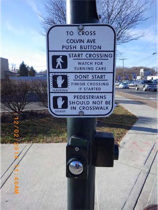
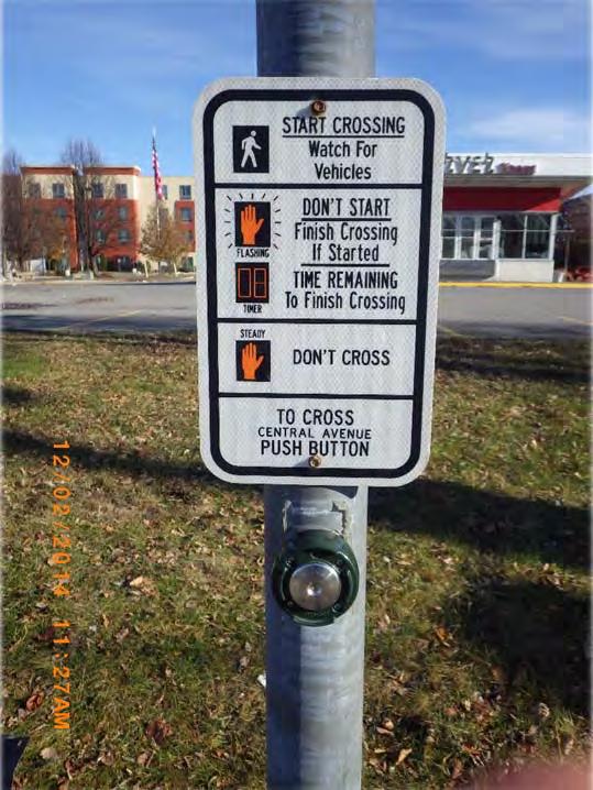
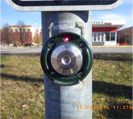
25 Responsive Pedestrian Buttons
26 Assessment of Available Ped. Features Intersection Operations Leading Pedestrian Interval Exclusive Pedestrian Phase No Turn on Red Signs (Active/Static) Pedestrian Clearance Pedestrian Accommodations Pedestrian Signal Compliance and Upgrades Responsive Push Buttons Crosswalk Presence (Marking a Crosswalk) Crosswalk Marking (Hi Visibility Crosswalks) Roadway Infrastructure Bus Stop Locations Lighting Levels Median Barrier Traffic Calming Road Diet Driver Feedback Signs Miscellaneous Yield to Pedestrian Sign


27 Education / Enforcement Governor s Traffic Safety Committee ndx.htm Education campaign announced September 15, 2014 Pedestrian Safety Education See, be seen How the systems works Use crossings Wait for Walk Cross with signal

28 Education / Enforcement Week long enforcement campaign announced on September 15, 2014 Goal of improving pedestrian safety Police Departments» Schenectady» Albany» Niskayuna» Colonie 298 total warnings with 170 warnings directly related to pedestrian error 352 total tickets issued with 71 summons directly related to pedestrian error One pedestrian accident witnessed in Schenectady
29 Suggested Improvements Schenectady NY Route 5/Brandywine Avenue INSERT SPECIFIC INTERSECTION EXAMPLES STATE STREET BRANDYWINE AVENUE
30 Suggested Improvements Schenectady Summarized accidents in Focus Area using typical TE 213 form 5 of 6 accidents were right angle collisions (4 associated with pedestrian confusion/error) One left turn accident associated with pedestrian confusion/error Accidents were shown on a collision diagrams to identify patterns

31 Suggested Improvements Schenectady Improvements were identified at each location

32 Suggested Improvements Schenectady Simulated intersection operations with a Leading Pedestrian Interval Phase City Concerns with coordination between Albany Street and McClellan Street

33 Suggested Improvements Schenectady NY Route 5/Brandywine Ave Install new traffic signal with LPI INSERT SPECIFIC INTERSECTION EXAMPLES STATE STREET BRANDYWINE AVENUE

34 Suggested Improvements Schenectady Used a light meter to observe existing conditions Visual 2012 was used to develop models of each location

35 Suggested Improvements Schenectady Below 0.75 fc 250w Luminaire 150w Luminaire Lighting Levels Current standards recommend 3.2 foot candles (fc) for the overall intersection Existing Levels = 1.1 fc

36 Suggested Improvements Schenectady Below 0.75 fc 400w Luminaire 400w Luminaire Lighting Levels Recommended Levels = 3.2 fc Existing Levels = 1.1 fc Bulb Upgrades = 2.1 fc
37 Suggested Improvements Schenectady 400w Luminaire 400w Luminaire 400w Luminaire Lighting Levels Recommended Levels = 3.2 fc Existing Levels = 1.1 fc Bulb Upgrades = 2.1 fc Additional Light Fixture Upgrade = 3.2 fc
38 Suggested Improvements NYSDOT NY Route 5/Osborne Road INSERT SPECIFIC INTERSECTION EXAMPLES OSBORNE ROAD CENTRAL AVENUE
39 Suggested Improvements NYSDOT A mix of right angle, left turn, and right turn accidents 3 of 4 accidents were a result of pedestrian confusion/error One fatal accident 40 feet east of intersection associated with pedestrian confusion/error Second fatal accident <800 feet west of intersection associated with pedestrian in median and vehicle traveling in median toward Osborne Road

40 Suggested Improvements NYSDOT

41 Suggested Improvements NYSDOT NY Route 5/Osborne Road Incorporated LPI INSERT SPECIFIC INTERSECTION EXAMPLES OSBORNE ROAD CENTRAL AVENUE

42 Suggested Improvements NYSDOT Colonie Center Median Concept
43 Suggested Improvements Albany NY Route 5/Lark Street LARK STREET CENTRAL AVENUE WASHINGTON AVENUE
44 Suggested Improvements Albany A mix of right angle (10), left turn (11), and right turn (6) accidents 10 of 27 accidents were a result of pedestrian confusion/error

45 Suggested Improvements Albany

46 Suggested Improvements Albany NY Route 5/Lark Street Incorporate Exclusive Pedestrian Phase LARK STREET CENTRAL AVENUE WASHINGTON AVENUE


47 Schedule Short Term (within 1 year) Pedestrian Timing/Phasing 10 Intersections Yield to Pedestrian Signs 10 Intersections Outside Focus Areas Pedestrian Signals 27 Intersections Marked Crosswalks 5 Intersections Bus Stop Locations 10 Locations

48 Schedule Short Term (within 1 year) Push Buttons Install responsive push buttons where push buttons are not present, where pedestrian accommodations are added, or where they were not identified under Immediate suggestions. This includes elevator and talking style push buttons. Traffic Signal Replacement The existing traffic signal at Brandywine Avenue will be replaced in order to incorporate the pedestrian accommodations and related timing changes. Raised Median A raised median barrier with a fence should be considered at Colonie Center to discourage the observed mid block crossing trend. A crosswalk with full pedestrian accommodations is also proposed on the eastern side of the raised median.


49 Engineering Schedule Long Term (as funding becomes available) Signal Timing Pedestrian Signals Crosswalk Styles Bus Stop Locations Lighting Driver Feedback Road Diet Before After
50 Discussion
Pedestrian Road Safety Audit
 Pedestrian Road Safety Audit Middlebrook Road From Father Hurley Boulevard to Waring Station Road December 2017 Montgomery County Department of Transportation Table of Contents 1. Introduction... 1 1.1
Lincoln Way Multimodal Safety and Operations Study. City and University Summary Presentation
 Lincoln Way Multimodal Safety and Operations Study City and University Summary Presentation February 27, 2018 Agenda Introductions Study Overview: Phase 1 - Discovery Phase 2 Improvement Recommendations
Pine Hills Road Pedestrian/Bicycle Safety Study Board of County Commissioners Work Session
 Pine Hills Road Pedestrian/Bicycle Safety Study Board of County Commissioners Work Session February 20, 2018 Meeting Agenda Study Overview Existing Conditions Access Management Potential Gateway Features
The DC Pedestrian Master Plan
 The DC Pedestrian Master Plan September 28, 2010 George Branyan Pedestrian Program Coordinator District Department of Transportation Presentation Agenda Scope of the Plan Methodology Recommendations Implementation
Retrofitting Urban Arterials into Complete Streets
 Retrofitting Urban Arterials into Complete Streets John N. LaPlante, P.E., P.T.O.E., T.Y. Lin International Prepared for: Illinois Traffic Engineering & Safety Conference Urbana, Illinois October 18, 2007
CITY OF LOS ANGELES INTER-DEPARTMENTAL MEMORANDUM
 CITY OF LOS ANGELES INTER-DEPARTMENTAL MEMORANDUM Date: April 1, 219 To: Honorable City Council c/o City Clerk, Room 395, City Hall Attention: Honorable Mike Bonin, Chair, Transportation Committee From:
Pedestrian Safety Guide for Transit Agencies
 Pedestrian Safety Guide for Transit Agencies FDOT/FTPA/CUTR Professional Development Workshop June 15, 2010 1 Purpose Presentation Overview Bus Stop Location and Design Process/Partnership 2 Purpose Every
Pinellas County Metropolitan Planning Organization (MPO) 2014 Crash Data Report
 2014 Crash Data Report") Pinellas County Metropolitan Planning Organization (MPO) 2014 Crash Data Report MPO Board July 8, 2015 2 Crash Data Collection Motorcycle drove between stopped cars, ran a red light and collided with a
Pinellas County Metropolitan Planning Organization (MPO) 2014 Crash Data Report MPO Board July 8, 2015 2 Crash Data Collection Motorcycle drove between stopped cars, ran a red light and collided with a
Active Transportation Facility Glossary
 Active Transportation Facility Glossary This document defines different active transportation facilities and suggests appropriate corridor types. Click on a facility type to jump to its definition. Bike
Public Involvement Meeting Tuesday, June 13, Albany Shaker Road Corridor Study
 Public Involvement Meeting Tuesday, June 13, 2017 Albany Shaker Road Corridor Study Agenda / Meeting Outline 1. Introduce the project 2. Complete Streets 3. Share/confirm our findings 4. Your Opinion 5.
Rank #1 Highest Priority Intersection
 Rank #1 Highest Priority Intersection Attachment 3: Proposed Interventions Pedestrian Safety City of Toronto s 10 Priority Intersections Sheppard Avenue East and Ambrose Road/Provost Drive Located in the
CTDOT Pedestrian and Bicycle Safety Initiatives
 CTDOT Pedestrian and Bicycle Safety Initiatives 2017 Northeast Transportation Safety Conference Mark F. Carlino, P.E. Traffic Engineering Division Chief Bureau of Engineering and Construction Connecticut
COWETA HIGH SCHOOL AND EAST HIGHWAY 51
 COWETA HIGH SCHOOL AND EAST HIGHWAY 51 Lack of sidewalks along Ben Lumpkin Rd. Lack of crosswalks and ramps at intersection. Hwy 51 is wide to cross as a pedestrian. No ADA compliance or connection to
This page intentionally left blank.
 This page intentionally left blank. COMMUNITY Coweta Community Overview Coweta Coweta, a residential community located in Wagoner County, is a suburb of Tulsa situated southeast of the metropolitan area
DEPARTMENT OF ENVIRONMENTAL SERVICES. North Harrison Street (Lee Highway to Little Falls Road) Comparative Analysis. Prepared for:
 Comparative Analysis. Prepared for:") DEPARTMENT OF ENVIRONMENTAL SERVICES North Harrison Street (Lee Highway to Little Falls Road) Comparative Analysis Prepared for: Arlington County Department of Environmental Services 2100 Clarendon Boulevard,
DEPARTMENT OF ENVIRONMENTAL SERVICES North Harrison Street (Lee Highway to Little Falls Road) Comparative Analysis Prepared for: Arlington County Department of Environmental Services 2100 Clarendon Boulevard,
City of Albert Lea Policy and Procedure Manual 4.10 ALBERT LEA CROSSWALK POLICY
 4.10 ALBERT LEA CROSSWALK POLICY PURPOSE: Pedestrian crosswalks are an integral part of our transportation infrastructure. To be effective and promote safety, marked crosswalks must be installed after
Designing for Pedestrians: An Engineering Symposium. Rutgers University March 21, 2013
 Designing for Pedestrians: An Engineering Symposium Rutgers University March 21, 2013 The Problem 2 Pedestrian Fatalities Pedestrian Fatalities by Year in US (1994-2010) 6000 5000 4000 3000 2000 1000 0
Appendix C. TRAFFIC CALMING PROGRAM TOOLBOX
 Appendix C. TRAFFIC CALMING PROGRAM TOOLBOX PHASE I...2 Do Not Enter Sign...3 One-Way Sign...4 Turn Prohibition...5 Pavement Markings...6 Speed Monitoring Trailer...7 Neighborhood Speed Watch...8 Police
MT. LEBANON COMPREHENSIVE PLAN UPDATE ELEVATING CONNECTIVITY FOR PEDESTRIANS AND CYCLISTS
 MT. LEBANON COMPREHENSIVE PLAN UPDATE ELEVATING CONNECTIVITY FOR PEDESTRIANS AND CYCLISTS Municipality of Mt. Lebanon, Allegheny County, Pennsylvania INTRODUCTION The Mt. Lebanon Comprehensive Plan Update
For Information Only. Pedestrian Collisions (2011 to 2015) Resolution. Presented: Monday, Apr 18, Report Date Tuesday, Apr 05, 2016
 Resolution. Presented: Monday, Apr 18, Report Date Tuesday, Apr 05, 2016") Presented To: Operations Committee For Information Only Pedestrian Collisions (0 to 0) Presented: Monday, Apr 8, 06 Report Date Tuesday, Apr 0, 06 Type: Correspondence for Information Only Resolution For
Presented To: Operations Committee For Information Only Pedestrian Collisions (0 to 0) Presented: Monday, Apr 8, 06 Report Date Tuesday, Apr 0, 06 Type: Correspondence for Information Only Resolution For
STATUS OF 2009 PEDESTRIAN MASTER PLAN (AS OF DECEMBER 2013)
") Appendix P.1 STATUS OF 2009 PEDESTRIAN MASTER PLAN (AS OF DECEMBER 2013) The 2009 Pedestrian Master Plan establishes 21 core recommendations in three goal areas to improve pedestrian transportation in
Appendix P.1 STATUS OF 2009 PEDESTRIAN MASTER PLAN (AS OF DECEMBER 2013) The 2009 Pedestrian Master Plan establishes 21 core recommendations in three goal areas to improve pedestrian transportation in
Americans with Disabilities Act Transition Plan for Public Right-of-Way Improvements
 Americans with Disabilities Act Transition Plan for Public Right-of-Way Improvements Prepared by: Public Works Department Engineering Division October 2015 Table of Contents Section I Introduction.. 3
Neighborhood Pedestrian Safety and Traffic Calming Study
 Neighborhood Pedestrian Safety and Traffic Calming Study for the area bounded by Foster Avenue, Bedford Avenue, Farragut Road and Ocean Avenue Flatbush, Brooklyn, New York prepared by Michael King, miking@trafficcalmer.com
INTERSECTION CRASH COUNTERMEASURES
 INTERSECTION CRASH COUNTERMEASURES ALL SEVERE INTERSECTION (include gap CRASHES High Friction Surface Treatment - Intersection Markings - advanced acceptance and intersection approaches to intersections
MONTCLAIR TOWNSHIP PEDESTRIAN SAFETY COMMITTEE
 + MONTCLAIR TOWNSHIP PEDESTRIAN SAFETY COMMITTEE + PEDESTRIAN SAFETY COMMITTEE CURRENT MISSION: The Committee was formed in 2013 to call attention to and eliminate unsafe conditions on Montclair streets
Albany Shaker Road Corridor Study Public Meeting # 2
 Albany Shaker Road Corridor Study Public Meeting # 2 Scope / Meeting Purpose This project is a CDTC Linkage Study. The Linkage Program is designed to implement the adopted planning and investment principles
PEDESTRIAN ACTION PLAN
 ATTACHMENT 2 CITY OF SANTA MONICA PEDESTRIAN ACTION PLAN CITY OF SANTA MONICA PEDESTRIAN ACTION PLAN This page intentionally left blank EXECUTIVE SUMMARY CHAPTER 1 EXECUTIVE SUMMARY Setting the Stage
MOBILITY WORKSHOP. Joint City Council and Transportation Commission May 5, 2014
 MOBILITY WORKSHOP Joint City Council and Transportation Commission May 5, 2014 Review of General Plan M-1 Develop world-class transit system M-3 Maintain/enhance pedestrian-oriented City M-4 Create comprehensive
THE NACTO MANUALS AND DESIGNING FOR VISION ZERO ZAKI MUSTAFA SHIRLEY ZAMORA
 THE NACTO MANUALS AND DESIGNING FOR VISION ZERO ZAKI MUSTAFA SHIRLEY ZAMORA NACTO Design Guides 2 City of Los Angeles Vision Zero 3 Vision Zero Roscoe Boulevard Corridor SHIRLEY ZAMORA TRANSPORTATION ENGINEERING
Traffic Improvements for the Transit Oriented Development District (TODD) Meriden Public Library March 11, 2014
 Meriden Public Library March 11, 2014") Traffic Improvements for the Transit Oriented Development District (TODD) Meriden Public Library March 11, 2014 Project Overview Coordinate roadway improvements with other major projects HUB Flood Control
Traffic Improvements for the Transit Oriented Development District (TODD) Meriden Public Library March 11, 2014 Project Overview Coordinate roadway improvements with other major projects HUB Flood Control
Transportation Planning Division
 Transportation Planning Division Presentation Outline Study Tasks Recap of Previous Meeting Stakeholder Interviews Data Collection Design Principles Tool Box Recommendations Schedule Moving Forward North
PEDESTRIAN ACCOMMODATIONS DPS 201 AT ROUNDABOUTS
 PEDESTRIAN ACCOMMODATIONS DPS 201 AT ROUNDABOUTS WHY THEY WORK FOR PEDESTRIANS IF DESIGNED CORRECTLY Separated sidewalks direct peds to crosswalks Splitter island Slow speed exit Truck apron Crosswalk
Designing for Pedestrian Safety in Washington, DC
 Designing for Pedestrian Safety in Washington, DC February 25, 2014 George Branyan Pedestrian Program Coordinator District Department of Transportation DC Journey to work mode split: 2012 Means of Transportation
Draft North Industrial Area-Wide Traffic Plan
 Summary of North Industrial and Hudson Bay Industrial Recommended Improvements Table 1. Summary of s Item Location 1 2 3 4 5 6 7 8 9 10 11 12 Millar Ave north of 51st St Super 8 Motel back lane 400 Block
Broad Street Bicycle Boulevard Design Guidelines
 Broad Street Bicycle Boulevard Design Guidelines Building from the strategies introduced in the 2013 Bicycle Transportation Plan and community input received thus far, City Transportation Staff have identified
About the Studio. Edward J. Bloustein School of Planning and Public Policy - Rutgers University
 About the Studio Edward J. Bloustein School of Planning and Public Policy - Rutgers University Purpose of studio: Help City of Bayonne apply for Safe Routes to School (SRTS) funding by producing a School
Closing Plenary Session
 TRAFFIC SAFETY CONFERENCE Closing Plenary Session June 9, 2017 Las Colinas, TX Order of Report Out June 9, 2017 Las Colinas, TX Distracted Driving Prioritized Countermeasures Countermeasure 4a Systemically
Appendix A: Crosswalk Policy
 Appendix A: Crosswalk Policy Appendix A: Crosswalk Policy Introduction This citywide Crosswalk Policy is aimed at improving pedestrian safety and enhancing pedestrian mobility by providing a framework
Watertown Complete Streets Prioritization Plan. Public Meeting #1 December 14, 2017
 Watertown Complete Streets Prioritization Plan Public Meeting #1 December 14, 2017 Goals for Public Meeting Overview of MassDOT Complete Streets Funding Program Educate the community on Complete Streets
Walk On, Victoria Pedestrian Issues Policy Research
 Issue: Distracted walking a. Study of police accident report data shows no correlation between distracted walking and an increase in injury or death, similar data for distracted driving shows a steep relationship.
WELCOME Public Information Centre
 WELCOME Public Information Centre Fernforest Drive Brampton Soccer Centre Community Room #2 Tuesday January 19, 2016 6:30 p.m.to 9:00 p.m. Please sign in Neighbourhood Traffic Calming Guide Background
Northbound San Jose Avenue & I-280 Off-Ramp Road Diet Pilot Project
 Project Overview Fed by a two-lane Interstate-280 (I-280) off-ramp, high vehicular volumes and speeds are longstanding issues along San Jose Avenue. Residents in the surrounding neighborhoods have expressed
US 41 (Tamiami Trail) Corridor Study. Roadway Safety Audit
 Corridor Study. Roadway Safety Audit") US 41 (Tamiami Trail) Corridor Study Roadway Safety Audit US 41 RSA June 14/15, 2017 Agenda Project Overview Schedule RSA Process Overview RSA Responsibilities Historical Crash Review 2 PROJECT OVERVIEW
US 41 (Tamiami Trail) Corridor Study Roadway Safety Audit US 41 RSA June 14/15, 2017 Agenda Project Overview Schedule RSA Process Overview RSA Responsibilities Historical Crash Review 2 PROJECT OVERVIEW
Improving intersections for people that walk in Minneapolis
 Matthew Dyrdahl, AICP, LCI Bicycle and Pedestrian Coordinator Minneapolis Public Works CITY OF MINNEAPOLIS Improving intersections for people that walk in Minneapolis Transportation Bonanza February 8,
Project Goal and Description. Why Broadway? Broadway SFMTA.COM/BROADWAY. The goal of the Broadway Safety Improvement
 PROJECT OVERVIEW Project Goal and Description The goal of the Broadway Safety Improvement d St Van Ness Ave Project is to improve safety and comfort for all who Franklin St Hyde St Octavia St Gough St
Road Safety Audit Course Participant Guidebook. August 22 & 23, Cleveland Avenue Columbus, Ohio
 Road Safety Audit Course Participant Guidebook August 22 & 23, 2017 Cleveland Avenue Columbus, Ohio 1 2 Table of Contents Executive Summary... 5 Cleveland Avenue City of Columbus... 6 Road Location Details...
Complete Street Analysis of a Road Diet: Orange Grove Boulevard, Pasadena, CA
 Complete Street Analysis of a Road Diet: Orange Grove Boulevard, Pasadena, CA Aaron Elias, Bill Cisco Abstract As part of evaluating the feasibility of a road diet on Orange Grove Boulevard in Pasadena,
5. RUNNINGWAY GUIDELINES
 5. RUNNINGWAY GUIDELINES These guidelines should be considered collectively when making runningway decisions. A runningway is the linear component of the transit system that forms the right-of-way reserved
Bangor, ME. August 9, A Joint Project of the Maine Department of Transportation and the Bicycle Coalition of Maine
 Bangor, ME August 9, 2017 A Joint Project of the Maine Department of Transportation and the Bicycle Coalition of Maine Welcome--Agenda Welcome: Intros, Agenda, Using Clicker Tech Perceptions and Realities
ROAD SAFETY AUDIT. County Street at Hart Street. City of Taunton. January 30, Prepared For: Massachusetts Department of Transportation
 ROAD SAFETY AUDIT County Street at Hart Street City of Taunton January 30, 2015 Prepared For: Massachusetts Department of Transportation Prepared By: Toole Design Group 33 Broad Street, 4 th Floor Boston,
MTCF. Michigan Traffic Crash Facts FACT SHEETS
 FACT SHEETS This page left intentionally blank GENERAL FACTS The driver, the roadway, and the motor vehicle contribute in some measure to every crash. A preponderance of evidence, however, points to driver
F L E T C H E R A V E N U E
 Jan. 29, 2014 Introduction F L E T C H E R A V E N U E FDOT Local Agency Program (LAP) Project FPN: 428214-1-58-01 CIP 63090 Hillsborough County, Traffic Engineering, PWD Stake holders and partners are
Hennepin Avenue Reconstruction Washington Avenue to 12 th Street
 CITY OF MINNEAPOLIS Hennepin Avenue Reconstruction Washington Avenue to 12 th Street April 2016 1 Upcoming Opportunities Public Meeting #2 April 25, 2016 Minneapolis Central Library Doty Board Room Repeat
IMPLEMENTATION. PEDESTRIAN USERS (Continued /) A: Class 2 Pedestrian / Cycle Ways. Pedestrian and Cycle Ways:
 A: Class 2 Pedestrian / Cycle Ways. Pedestrian and Cycle Ways:") A: Class 2 Pedestrian / Cycle Ways PLAN VIEW Pedestrian and Cycle Ways: Layout and Geometry (Refer to A): Walkways and cycle to be provided adjacent to all Class 2 Roads (these facilities should always
A: Class 2 Pedestrian / Cycle Ways PLAN VIEW Pedestrian and Cycle Ways: Layout and Geometry (Refer to A): Walkways and cycle to be provided adjacent to all Class 2 Roads (these facilities should always
Caltrans Sloat Boulevard Pedestrian Safety Project Response to Community Questions, Comments & Concerns
 Caltrans Sloat Boulevard Pedestrian Safety Project Response to Community Questions, Comments & Concerns Revised: May 10, 2016 The California Department of Transportation (Caltrans) is planning various
City of Madison, WI. Crash Report
 City of Madison, WI 2009 Crash Report 2009 City of Madison, WI Traffic Engineering Division Crash Report Table of Contents Page Annual Crash Overview... 1 Crash Totals... 1 5-Year Graphical Crash History...
Rightsizing Streets: The Seattle Experience
 Rightsizing Streets: The Seattle Experience April 30, 2013 Brian Dougherty Seattle Department of Transportation Complete Streets 16% of households do not have a car Seniors Youth Transit riders Safety
Military Road Safety Improvements
 Military Road Safety Improvements 26 th Road North to 31 st Street North SUMMARY OF DATA REVIEW AND PRELIMINARY RECOMMENDATIONS Prepared for: Department of Environmental Services Traffic Engineering and
MCARTHUR AVENUE AS WE HEARD IT REPORT CYCLING LANES. City of Ottawa Transportation Services. Photo: istock
 MCARTHUR AVENUE CYCLING LANES Photo: istock AS WE HEARD IT REPORT City of Ottawa Transportation Services CONTENTS Background...1 Consultation Activities Summary...1 Public Commentary Questionnaire Results...2
Lessons Learned from Cycle Tracks (Class IV Bikeways) Design Practice
 Design Practice") Lessons Learned from Cycle Tracks (Class IV Bikeways) Design Practice By: Min Zhou, P.E., Principal/Vice President KOA Corporation 1 What is a Cycle Track (Class IV) TYPICAL BIKEWAY CLASSIFICATION CLASS
Lessons Learned from Cycle Tracks (Class IV Bikeways) Design Practice By: Min Zhou, P.E., Principal/Vice President KOA Corporation 1 What is a Cycle Track (Class IV) TYPICAL BIKEWAY CLASSIFICATION CLASS
CITY OF OTTAWA ROADWAY MODIFICATION APPROVAL UNDER DELEGATED AUTHORITY
 RMA-2015-ATM-038 CITY OF OTTAWA ROADWAY MODIFICATION APPROVAL UNDER DELEGATED AUTHORITY DATE: April 22, 2015 SUBJECT Approval of Roadway Modifications Recommended through an Area Traffic Management Study
Road Diets FDOT Process
 Florida Department of TRANSPORTATION Road Diets FDOT Process Humberto Castillero, PE, PTOE Roadway Design Office Purpose of Guide Develop a statewide lane elimination review process Balance state & local
Agenda. Overview PRINCE GEORGE S PLAZA METRO AREA PEDESTRIAN PLAN
 PRINCE GEORGE S PLAZA METRO AREA PEDESTRIAN PLAN May 28, 2008 Agenda Welcome and introductions Project overview and issue identification Planning context and strengths Design challenges and initial recommendations
REGIONAL BICYCLE AND PEDESTRIAN DESIGN GUIDELINES
 REGIONAL BICYCLE AND PEDESTRIAN DESIGN GUIDELINES November 16, 2011 Deb Humphreys North Central Texas Council of Governments Bicycle and Pedestrian Advisory Committee Snapshot of the Guide 1. Introduction
Citywide Sidewalk and Crosswalk Programs
 Citywide Sidewalk and Crosswalk Programs Council Meeting October 20, 2015 Presented by Rita Hu and Jamal Mahmoud Program Goals Implement the City s comprehensive plan. Provide pedestrian with safe walking
CAPITOL DRIVE & FOND DU LAC AVENUE INTERSECTION ANALYSIS. Urban Planning 772 SARAH BREGANT, RYAN PETERSON, & MATT WERDERITCH
 CAPITOL DRIVE & FOND DU LAC AVENUE INTERSECTION ANALYSIS Urban Planning 772 SARAH BREGANT, RYAN PETERSON, & MATT WERDERITCH OVERVIEW N 51 ST BOULEVARD N 51 ST BOULEVARD 12,100 44,700 W CAPITOL DRIVE 52,600
Safe Routes to School: Munroe Elementary Walk Audit Report. Image: Drexel, Barrell & Co.
 Safe Routes to School: Munroe Elementary Walk Audit Report Image: Drexel, Barrell & Co. April 12, 2016 OVERVIEW As part of the 2014/2015 Denver Safe Routes to School (SRTS) Program, WalkDenver coordinated
PEDESTRIAN CROSSING TREATMENTS
 PEDESTRIAN CROSSING TREATMENTS BEST PRACTICES Presented by: Doug Enderson, P.E., PTOE Cody Salo, P.E. 1 PRESENTER INTRODUCTIONS Doug Enderson, P.E., PTOE Ped Crossing Experience: ADA Design-Build ADA Inventory
Most Dangerous Roads for Walking And How States Can Make them Safer. Route 110, Long Island, New York Image by Dougtone
 Most Dangerous Roads for Walking And How States Can Make them Safer Route 110, Long Island, New York Image by Dougtone Tri-State Transportation Campaign February 2013 Introduction Key Findings More than
MTCF. Michigan Traffic Crash Facts FACT SHEETS
 FACT SHEETS This page left intentionally blank GENERAL FACTS The driver, the roadway, and the motor vehicle contribute in some measure to every crash. A preponderance of evidence, however, points to driver
APPENDIX A: Complete Streets Checklist DRAFT NOVEMBER 2016
 APPENDIX A: Complete Streets Checklist DRAFT NOVEMBER 2016 Complete Streets Checklist MetroPlan Orlando s Complete Streets Checklist is an internal planning tool for staff to further implementation of
City of Prince Albert Statement of POLICY and PROCEDURE. Department: Public Works Policy No. 66. Section: Transportation Issued: July 14, 2014
 Page: 1 of 8 1 POLICY 1.01 The City shall follow all of the specifications in the Manual of Uniform Traffic Control Devices for Canada, prepared by the National Committee of Uniform Traffic Control, and
Topsham, ME. September 20, A Joint Project of the Maine Department of Transportation and the Bicycle Coalition of Maine
 Topsham, ME September 20, 2017 A Joint Project of the Maine Department of Transportation and the Bicycle Coalition of Maine Agenda Welcome: Intros, Agenda, Using Clicker Tech Perceptions and Realities
Pine Hills Road Pedestrian/Bicycle Safety Study Community Meeting #1
 Pine Hills Road Pedestrian/Bicycle Safety Study Community Meeting #1 June 8, 2017 Meeting Agenda Study Overview Community Survey Existing Conditions Access Management Potential Safety Countermeasures Potential
Pedestrian Safety: A Federal Perspective. Emmett McDevitt Transportation Safety Engineer September 28, 2010
 Pedestrian Safety: A Federal Perspective Emmett McDevitt Transportation Safety Engineer September 28, 2010 Pedestrian Fatalities by Year in US (1997-2009) 6,000 5,000 4,000 3,000 2,000 1,000 0 1997 1998
Downtown BRT Corridor Alternatives Review: 1 st, 2 nd, 3 rd and 4 th Avenue. Bus Rapid and Conventional Transit Planning and Design Services
 Downtown BRT Corridor Alternatives Review: 1 st, 2 nd, 3 rd and 4 th Avenue Bus Rapid and Conventional Transit Planning and Design Services City of Saskatoon February 2018 Project Team HDR Corporation
Public Information Centre
 WELCOME Public Information Centre Father Tobin Road Lougheed Middle School - Library Wednesday November 7, 2012 7:00 p.m.to 9:00 p.m. Please sign in Neighbourhood Traffic Calming Guide Background The City
Speed Management Action Plan
 Speed Management Action Plan National Selection Criteria Criteria Description Fatalities The number of fatalities resulting from speeding-related crashes. Percentage Compares total fatalities in each State
FHWA Resources for Pedestrian and Bicycle Professionals
 FHWA Resources for Pedestrian and Bicycle Professionals Charlie Zegeer, UNC Highway Safety Research Center/PBIC Libby Thomas, UNC Highway Safety Research Center Dan Nabors, Vanasse Hangen Brustlin (VHB)
Balancing Highway Speeds and Community Needs
 Balancing Highway Speeds and Community Needs State/Tribal Transportation Conference September 2016 Three parts to this session: Session Overview What are the WSDOT considerations? What are issues we are
Acknowledgements. Mr. David Nicol 3/23/2012. Daniel Camacho, P.E. Highway Engineer Federal Highway Administration Puerto Rico Division
 Daniel Camacho, P.E. Highway Engineer Federal Highway Administration Puerto Rico Division Acknowledgements Mr. David Nicol Director, FHWA Office of Safety FHWA Office of Safety http://safety.fhwa.dot.gov/provencountermeasures/
REDUCING COLLISIONS AT HIGH CRASH LOCATIONS
 REDUCING COLLISIONS AT HIGH CRASH LOCATIONS Presented by Nazir Lalani P.E. Traffex Engineers Inc. N_lalani@hotmail.com ACCIDENTS AND SAFETY Why is safety important? Safety components Who is responsible?
MINERAL AVENUE CORRIDOR ASSESSMENT STUDY IMPLEMENTATION STRATEGY
 MINERAL AVENUE CORRIDOR ASSESSMENT STUDY IMPLEMENTATION STRATEGY INTRODUCTION City Personnel Sign-in Sheet Comment Forms Please Write Down Any Feedback INTRODUCTION List of Topics for Presentation Study
Public Works Committee Meeting Richard E. Mastrangelo Council Chamber November 20, 2017
 Public Works Committee Meeting Richard E. Mastrangelo Council Chamber November 20, 2017 Purpose of Meeting Why are we here? Project Recap/Updates Project Limits/Segments Road Diet Concept Lessons Learned
Study Area and Location District PSA Ward ANC Phase Description B Existing 2500 Block Naylor Road Southeast Northbound
 Speed Limit and Safety Nexus Studies for Automated Enforcement Locations in the District of Columbia 25 Block Naylor Road SE Study Area and Location District PSA Ward ANC Phase Description 7 71 7 7B Existing
SAFE ROUTES TO SCHOOL (SR2S)
") SAFE ROUTES TO SCHOOL (SR2S) In partnership with Burbank Unified School District (BUSD) & City of Burbank George Washington Elementary School Thomas Jefferson Elementary School John Muir Middle School
SAFE ROUTES TO SCHOOL (SR2S) In partnership with Burbank Unified School District (BUSD) & City of Burbank George Washington Elementary School Thomas Jefferson Elementary School John Muir Middle School
Welcome! San Jose Avenue Open House August 25, 2015
 Welcome! San Jose Avenue Open House August 25, 2015 Vision Zero The City and County of San Francisco adopted Vision Zero San Francisco Vision Zero High Injury Network as a policy in 2014, committing an
Hillsborough Pedestrian Safety Action Plan 2015 Update. Hillsborough MPO BPAC May 2015
 Hillsborough Pedestrian Safety Action Plan 2015 Update Hillsborough MPO BPAC May 2015 Presentation Overview Pedestrian Safety Action Plan (PSAP) Review Pedestrian Crash Trends Stakeholder Activities Engineering
KIETZKE LANE SAFETY MANAGEMENT PLAN FINAL REPORT August, 2013 Submitted By: Parsons. Submitted to:
 KIETZKE LANE SAFETY MANAGEMENT PLAN FINAL REPORT August, 2013 Submitted By: Parsons Submitted to: KIETZKE LANE SAFETY MANAGEMENT PLAN EXECUTIVE SUMMARY The Nevada Department of Transportation (NDOT) has
Toolbox of Countermeasures and Their Potential Effectiveness to Make Intersections Safer
 8 Toolbox of Countermeasures and Their to Make Intersections Safer Introduction Studies included in the NCHRP 17-18 (3), Guidance for Implementation of the AASHTO Strategic Highway Safety Plan, as well
Major Bike Routes 102 Avenue Workshop April 21, 2015
 Major Bike Routes 102 Avenue Workshop April 21, 2015 Our Purpose Today Provide context on how Major Bike Routes fit into Edmonton s future Share information on what we heard in our last phase, and how
BETHEL ROAD AND SEDGWICK ROAD CORRIDOR STUDY
 DRAFT PLAN City Council Meeting August 14, 2017 STUDY AREA Sedgwick Corridor State Route 160, principal arterial with Class 3 access management designation, commuter and freight route, connection to SR
Balancing Operation & Safety for Motorized and Non-Motorized Traffic
 Balancing Operation & Safety for Motorized and Non-Motorized Traffic Brian Willham, PE, PTOE Iowa Director - MOVITE June 30, 2014 Learning Objectives: When & Why should we measure the performance of complete
Taking a Step back, can we make crossing the street less chancy? Kerry Wilcoxon City of Phoenix Street Transportation Department
 Taking a Step back, can we make crossing the street less chancy? Kerry Wilcoxon City of Phoenix Street Transportation Department What are the realities? Pedestrian Source - Neighborhood - Bus Stop - Business
CITY OF HAMILTON PLANNING AND ECONOMIC DEVELOPMENT DEPARTMENT Transportation Planning and Parking Division
 CITY OF HAMILTON PLANNING AND ECONOMIC DEVELOPMENT DEPARTMENT Transportation Planning and Parking Division TO: Chair and Members Public Works Committee COMMITTEE DATE: June 18, 2018 SUBJECT/REPORT NO:
10.0 CURB EXTENSIONS GUIDELINE
 10.0 CURB EXTENSIONS GUIDELINE Road Engineering Design Guidelines Version 1.0 March 2017 City of Toronto, Transportation Services City of Toronto Page 0 Background In early 2014, Transportation Services
Meeting Schedule 7:00-7:15 Open House 7:15-7:45 Existing Conditions/Short-Term Improvements Study Presentation 7:45-8:00 Q&A Session 8:00-8:10
 Meeting Schedule 7:00-7:15 Open House 7:15-7:45 Existing Conditions/Short-Term Improvements Study Presentation 7:45-8:00 Q&A Session 8:00-8:10 Long-Term Study Presentation 8:10-8:40 Table Discussions 8:40-9:00
Transportation Planning Division
 Transportation Planning Division Presentation Outline Study Tasks Recap of Previous Meetings Data Collected Focus Areas within Study Limits Design Principles Tool Box Recommended Concepts Schedule Moving
Geary Corridor Bus Rapid Transit
 Geary Corridor Bus Rapid Transit Near-term Improvements Update SAN FRANCISCO COUNTY TRANSPORTATION AUTHORITY SAN FRANCISCO MUNICIPAL TRANSPORTATION AGENCY Phasing Packages Phase 1 Near-term: Delivers project
Town of Bethlehem. Planning Assessment. Bethlehem Town Board
 Town of Bethlehem US 9W Corridor Transportation Planning Assessment Presented e to: Bethlehem Town Board June 2009 Overview Study Background Route 9W Corridor Conditions and Improvements Selkirk Bypass