MBTA Key Bus Route. Community Meeting Route 1 - Cambridge
|
|
|
- Hortense Weaver
- 6 years ago
- Views:
Transcription
1 MBTA Key Bus Route Improvement Program Community Meeting Route 1 - Cambridge Cambridge Senior Center, Central Square Agenda Welcome and introductions Safety briefing/accommodations Key Bus Route Program overview Existing conditions Recommendations Next Steps Discussion 2 1

2 Introduction Enhancements to 15 Key Bus Routes Funded by $10 million ARRA grant 3 Implementation Process Coordination with municipalities Development of initial concepts Community meetings Incorporation of public comments Refinement of concepts and final community buy-in Final design and construction 4 2
3 Project Schedule Bus Route 1 Develop Concept Jan/ Feb Apr Jun 2012 Mar Finalize Plan Engineering Implementation Public Process 5 1/19 1/20 2/2 3/8 6/13 6/14 Key Bus Route Goals Reliability less bus bunching Faster service fewer delays, less stops, shorter trip times Improved accessibility p Passenger amenities for seniors and persons with disabilities shelters, benches, signage, trash receptacles 6 3


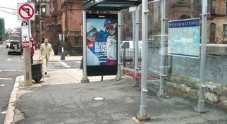
4 Typical Conditions Bus stop too short Signage issues Poorly located boarding area 7 Bus stops too close Improved Accessibility Legal Mandate All bus doors must open at curb Deter cars from parking in stops Providing accessible curb access requires longer bus stops Bus Stops must meet Current Guidelines for 40 buses 8 8 4

 100ft")

5 Farside 60ft Nearside 80ft Required Bus Stop Lengths 9 Midblock (or after left hand turn) 100ft Reliability Issues Bus bunching Overcrowding On-time performance 10 5

6 Preferred Bus Stop Locations Sufficient length to allow buses to pull to the curb Clear boarding/alighting area Not blocking crosswalks or driveways Considerate of adjacent traffic Appropriate distance between stops 11 Factors for Improving Stop Locations Ridership customer boardings and alightings Proximity to schools, medical centers etc Distance to adjacent stops Reducing traffic congestion Parking impacts Potential to add amenities shelters, benches etc. 12 6
 (4-6 minutes walking distance) Route")


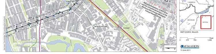
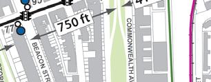
7 Bus Stop Spacing Ideal spacing is 4-7 stops per mile (every 750-1,320 ft) (4-6 minutes walking distance) Route 1 has stops as close as 260 ft Bus Stop Consolidation Benefits Shortens bus trip times Improves service reliability Minimizes stop & go experience Provides additional parking spaces Ability to provide better stop amenities 14 7


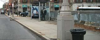
8 Traffic Signal Improvements Provide advance green time for buses Reduce overall congestion Requires coordination with roadway authority 15 Improved Amenities Trash receptacles Shelters 16 Benches Pavement markings 8


9 Improving Customer Information 17 Route 1: Overview Harvard Square to Dudley Station Via Mass Ave, Central Sq. Cambridge, and South End Harvard University, MIT, Boston Medical Center, Symphony Hall 5 miles long Run time varies by time of day (20-39 min.) Connects to: Red, Green, Orange & Silver Lines 30+ bus routes, including: KBR 15, 23, 28,39, 57, 66, 71, 73,

10 Route 1: Overview MBTA s 4 th busiest route Over 12,300 avg. daily boardings Peak Hour Headways Every 7-9 minutes On-time performance 65% weekdays Source:MBTA s 2008 Biennial Service Plan 69 stops 35 inbound (to Dudley) 34 outbound (to Harvard) 19 Proposed Recommendations (updated) 20 10

11 30% Design Plans 21 Boston Improvements 22 11


12 Mass Mass Ave Station Pavement markings/crossing improvements. 23 June Leading 13, 2011 the Nation in Transportation Excellence Mass Christian Science OB Consolidate Westland Ave with Clearway St. Construct landing area and add shelter and pavement markings. 90 Proposed


13 Mass Christian Science OB Consolidate Westland Ave with Clearway St. Construct landing area and add shelter and pavement markings. 25 Mass Christian Science IB Consolidate Christian Science Center with Westland Ave. Add shelter, trash receptacle and pavement markings. 81 Proposed


14 Mass Christian Science IB Consolidate Christian Science Center with Westland Ave. Add shelter, trash receptacle and pavement markings. 27 Mass Belvidere St Remove stop to provide better bus stop spacing and improve pedestrian and vehicle flow


15 Mass Boylston Street Investigate shared bus/right turn lane Outbound Inbound 29 June Leading 13, 2011 the Nation in Transportation Excellence Mass Hynes/Newbury St Repair sidewalk; consider adding bus lane


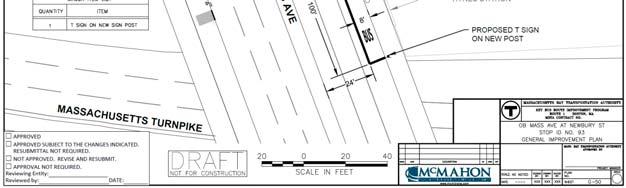
16 Mass Hynes/Newbury St Relocate OB stop closer to Green Line Station. Add pavement markings, bus lane, and bus advance signal. 93 Proposed 31 Mass Hynes/Newbury St Relocate OB stop closer to Green Line Station. Add bus lane and TSP

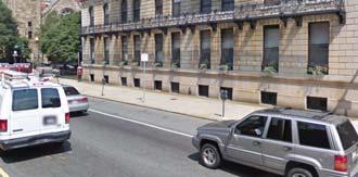
17 Mass Comm Ave Remove inbound/outbound stops and relocate shelters Leading the Nation in Transportation 94 Excellence Mass Beacon Street Retain stops. Investigate shelter at OB stop


18 Cambridge Improvements 35 Mass Memorial Dr IB Remove stop due to stop spacing and to improve traffic flow


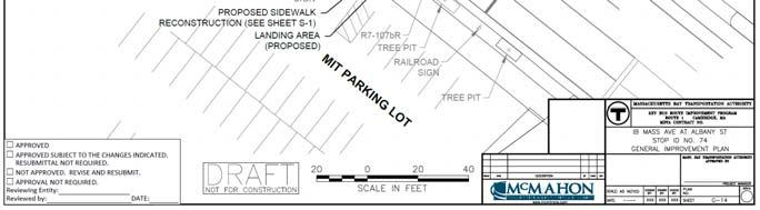
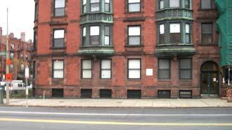
19 Mass Albany St IB Eliminate driveway, reconstruct sidewalk Mass Albany St IB Eliminate driveway, reconstruct sidewalk


20 Mass Landsdowne/Front St Eliminate inbound/outbound stops Mass Pleasant St Lengthen stop and add pavement markings


21 Mass Hancock/Sellers St IB Lengthen Hancock St stop to ; add bench and pavement markings. Remove Sellers St stop due to low ridership and to improve bus stop spacing Mass Clinton St Remove OB stop due to low ridership and to improve bus stop spacing


22 Mass Hancock/Dana St Relocate OB Hancock St stop farside of Hancock St. Remove Dana St Stop. 107 Proposed Mass Johnston Gate Add shelter, bench, and pavement markings


23 Mass Johnston Gate Add shelter, bench, and pavement markings. 45 Quincy Harvard St Repaint pavement markings. Proposal to relocate stop to nearside of Harvard St withdrawn
24 Summary of Preliminary Recommendations Add benches, trash receptacles, pavement markings, shelters Stops lengthened for accessibility Stops relocated Stops Consolidated Current Stop Plan 36 IB/33 OB Proposed Stop Plan 28 IB/26 OB Investigating traffic signal improvements Sidewalk Improvements 47 Summary of Preliminary Recommendations IB OB Total Total existingstops Existing stops lengthened Existing stops relocated Proposed stops Proposed shelters Proposed benches Proposed trash receptacles Parking added Parking removed


25 Project Schedule Bus Route 1 Develop Concept Jan/ Feb Apr Jun 2012 Mar Finalize Plan Engineering Implementation Public Process 49 1/19 1/20 2/2 3/8 6/13 6/14 Public Outreach 50 25


26 51 Comments and Next Steps Project Updates at Mail to Operations and Service Development, 45 High St, Boston, MA to Comments due by June 30, 2011 Next community meeting Route 57: June 22 Boston Route 66: June 23 Mission Hill Discussion 52 26
27 Discussion We want to hear from you! 53 27
MBTA Key Bus Route Improvement Program. Community Meeting Route 1 - Boston
 MBTA Key Bus Route Improvement Program Community Meeting Route 1 - Boston January 24, 2011 USES, 566 Columbus Ave., Boston Agenda Welcome and introductions Safety briefing/accommodations Key Bus Route
MBTA Key Bus Route Improvement Program. Community Meeting Route 66 - Brookline
 MBTA Key Bus Route Improvement Program Community Meeting Route 66 - Brookline February 9, 2011 Brookline Town Hall, 333 Washington St., Brookline Agenda Welcome and introductions Safety briefing/accommodations
MBTA Key Bus Route. Community Meeting Route 66 - Boston
 MBTA Key Bus Route Improvement Program Community Meeting Route 66 - Boston Jackson Mann Community Center Agenda Welcome and introductions Safety briefing/accommodations Key Bus Route Program overview Existing
MBTA Key Bus Route Improvement Program. Community Meeting Route 28
 MBTA Key Bus Route Improvement Program Community Meeting Route 28 April 5, 2012 Boston Public Library Mattapan Branch Agenda Welcome and introductions Safety briefing/accommodations Key Bus Route Program
MBTA Route 39 Key Bus Route Improvement Program
 MBTA Route 39 Key Bus Route Improvement Program Presentation of Improvements Kennedy School 7 Bolster Street Jamaica Plain Agenda Welcome and Introductions Overview of Route 39 Improvement Program Final
California Department of Transportation, District 4. Sloat Boulevard Project Skyline Blvd. to 19 th Ave. Community Update January 13, 2016
 California Department of Transportation, District 4 Sloat Boulevard Project Skyline Blvd. to 19 th Ave. Community Update January 13, 2016 Agenda Welcome and introductions Project overview, history and
TRANSPORT CHICAGO: STRATEGIC PUBLIC TRANSIT BUS RELIABILITY IMPROVEMENTS
 TRANSPORT CHICAGO: STRATEGIC PUBLIC TRANSIT BUS RELIABILITY IMPROVEMENTS Presented by David VanderZee and Jack Chalabian Monday, June 02, 2014 Overview of Strategic Route Management CTA Strategic Route
CURBSIDE ACTIVITY DESIGN
 5 CURBSIDE ACTIVITY DESIGN This chapter provides design guidance for separated bike lanes adjacent to curbside activities including parking, loading and bus stops. Typical configurations are presented
Providence Downtown Transit Connector STAKEHOLDER MEETING #2. Stakeholder Meeting #1 October 24, 2016
 Providence Downtown Transit Connector STAKEHOLDER MEETING #2 Stakeholder Meeting #1 October 24, 2016 February 2017 1 AGENDA 1 DTC Goals and Expectations 2 Street Design Concepts 3 Potential Benefits and
M14A/D Select Bus Service
 M14A/D Select Bus Service Manhattan Community Board 6: April 1, 2019 New York City Transit 2 Background M14 Select Bus Service M14 was identified as a critical future SBS corridor in past BRT studies as
Chapter 3 BUS IMPROVEMENT CONCEPTS
 Chapter 3 BUS IMPROVEMENT CONCEPTS The purpose of this chapter is to describe potential bus improvement strategies and potential impacts or implications associated with BRT implementation within the existing
ALTERNATIVES TO BE CONSIDERED
 ALTERNATIVES TO BE CONSIDERED EXISTING CONDITIONS (BASE CASE) In order to evaluate and understand the potential benefits and impacts of introducing downtown transit improvements in Providence, a Base Case
September 20, 2016 L Taraval Rapid Project SFMTA Board of Directors Meeting
 September 20, 2016 L Taraval Rapid Project SFMTA Board of Directors Meeting WHY TARAVAL STREET L TARAVAL PROJECT GOALS 1. Improve state of good repair of our transit system Track and overhead replacement
Pine Hills Road Pedestrian/Bicycle Safety Study Board of County Commissioners Work Session
 Pine Hills Road Pedestrian/Bicycle Safety Study Board of County Commissioners Work Session February 20, 2018 Meeting Agenda Study Overview Existing Conditions Access Management Potential Gateway Features
Contents. Champaign-Urbana Mass Transit District Stop Placement Guidelines
 Contents Champaign-Urbana Mass Transit District Introduction... 1 Stop Spacing... 2 Rural... 2 Low Density Suburban... 2 General Urban... 2 Urban Core... 2 Operational Safety... 3 Stop Placement... 4 Nearside
95 th Street Corridor Transportation Plan. Steering Committee Meeting #2
 95 th Street Corridor Transportation Plan Steering Committee Meeting #2 February 18, 2015 PURPOSE OF THE MEETING Update Steering Committee Present Community/Stakeholder Survey Results Present Transportation
Station Plan: Penn & 43rd Avenue
 Station Plan: Penn & 43rd Avenue This station will serve the northern portion of the Penn Avenue corridor, including the commercial node at 44th Avenue. Ridership and roadway geometry support station siting
Public Works Committee Meeting Richard E. Mastrangelo Council Chamber November 20, 2017
 Public Works Committee Meeting Richard E. Mastrangelo Council Chamber November 20, 2017 Purpose of Meeting Why are we here? Project Recap/Updates Project Limits/Segments Road Diet Concept Lessons Learned
Better Market Street. Engineering, Maintenance & Safety Committee (EMSC) February 28, 2018
 February 28, 2018") Better Market Street Engineering, Maintenance & Safety Committee (EMSC) February 28, 2018 1 Market Street Market Street - San Francisco by rulenumberone2 2 Market Street is the... City s busiest pedestrian
Better Market Street Engineering, Maintenance & Safety Committee (EMSC) February 28, 2018 1 Market Street Market Street - San Francisco by rulenumberone2 2 Market Street is the... City s busiest pedestrian
Welcome! Thank you for joining us today for a Geary Rapid project open house. Geary Rapid Project. SFMTA.com/GearyRapid
 Welcome! Thank you for joining us today for a Geary Rapid project open house. Get the most out of this event: 1. Sign in and get your feedback sheet 2. Visit project information stations hosted by project
Mission-Geneva Transportation Study Community Workshop 2 July 8, 2006
 Community Workshop 2 July 8, 2006 Small Group Workbook 1 Basic Improvements on Mission Street Streetscape. Pedestrian-scale lighting; landscaping; community art on utility boxes; more (possibly unique)
Roadways. Roadways III.
 Introduction 97 Roadway Design Principles 98 Safe Speeds 99 Optimizing of Street Space 00 Minimum Lane Widths in the City of Boston 02 Design Features that Reduce Operating Speeds 05 Travel Lanes Transit
Community Meeting February 27, 2007 Dorchester Avenue Transportation & Streetscape Improvements Action Plan February 27, 2007
 Community Meeting Tonight s Agenda 6:00 Introductions South Boston/Dot Ave Improvement Study Background 6:15 Consultant Introductions Review of Scope and Schedule Review of Proposed Corridor Wide Guidelines
MASSACHUSETTS AVENUE BRIDGE REPLACEMENT PROJECT APRIL 25, 2018
 MASSACHUSETTS AVENUE BRIDGE REPLACEMENT PROJECT APRIL 25, 2018 AGENDA Introductions Project Benefits Progress to Date Schedule for Remaining Work Phase 3 Activities, Impacts & Traffic Detours Phase 4 Activities
GENERAL. 1. Description
 GENERAL 1. Description This standard identifies minimum requirements that shall be met for all Bus Stops in the design and construction of elements for Arlington County Horizontal Design Standards. This
ALTERNATIVE A ONLY. Right Turn Only. BOTH ALTERNATIVES on southbound Mission from 23rd St to 25th St and on northbound Mission from 20th St to 23rd St
 Proposal Detail: 22nd on southbound Mission from on both sides of Mission from to 23rd from at northbound Mission and 22nd St and at at northbound Mission and 23rd St Reconfigure Lanes ONLY No Parking
9. TRANSIT ACCOMMODATIONS
 9. TRANSIT ACCOMMODATIONS INTRODUCTION... 1 FDOT District Four Facilities Guidelines... 1 ESSENTIAL PRINCIPLES OF DESIGNING STREETS FOR TRANSIT... 1 ACCESS TO TRANSIT... 2 BUS STOPS... 3 Layout... 3 -Specific
Tonight is for you. Learn everything you can. Share all your ideas.
 Strathcona Neighbourhood Renewal Draft Concept Design Tonight is for you. Learn everything you can. Share all your ideas. What is Neighbourhood Renewal? Creating a design with you for your neighbourhood.
C Line Rapid Bus Preliminary Station Design
 C Line Rapid Bus Preliminary Station Design C Terrence Anderson, Community Outreach Coordinator Shawn Walding, Senior Engineer Metro Transit TAAC February 1, 2016 1 C Line project overview Substantially
Wilshire Boulevard Bus Rapid Transit Project
 Los Angeles County Metropolitan Transportation Authority Wilshire Boulevard Bus Rapid Transit Project COMMUNITY MEETINGS November 2008 Agenda Introduction Proposed Project Overview Participating Agencies
Pine Hills Road Pedestrian/Bicycle Safety Study Community Meeting #1
 Pine Hills Road Pedestrian/Bicycle Safety Study Community Meeting #1 June 8, 2017 Meeting Agenda Study Overview Community Survey Existing Conditions Access Management Potential Safety Countermeasures Potential
Arterial Transitway Corridors Study. Ave
 Arterial Transitway Corridors Study Ave January 2012 Arterial Transitway Corridors Study Overview Corridor Features and Demographics 11 study corridors, 95 route miles 86,000 daily rides and half of existing
Caltrans Sloat Boulevard Pedestrian Safety Project Response to Community Questions, Comments & Concerns
 Caltrans Sloat Boulevard Pedestrian Safety Project Response to Community Questions, Comments & Concerns Revised: May 10, 2016 The California Department of Transportation (Caltrans) is planning various
Service Analysis INTRODUCTION
 Service Analysis INTRODUCTION The Everett Transit Action Plan is an initiative to develop near and long-term solutions to improve transit for the residents and workers of Everett. As an initial step in
Community Task Force November 15, 2017
 Community Task Force November 15, 2017 Welcome and Introductions Project Partners Regional Transportation District (RTD) Colorado Department of Transportation (CDOT) Denver Regional Council of Governments
Technical Working Group November 15, 2017
 Technical Working Group November 15, 2017 Welcome and Introductions Project Partners Regional Transportation District (RTD) Colorado Department of Transportation (CDOT) Denver Regional Council of Governments
Everett Transit Action Plan. Community Open House November 16, 2015
 Everett Transit Action Plan Community Open House Everett has a great location, but getting around the city and into surrounding communities is a problem for all ages Many Voices, One Future: The Everett
Geary Corridor Bus Rapid Transit
 Geary Corridor Bus Rapid Transit Near-term Improvements Update SAN FRANCISCO COUNTY TRANSPORTATION AUTHORITY SAN FRANCISCO MUNICIPAL TRANSPORTATION AGENCY Phasing Packages Phase 1 Near-term: Delivers project
9. TRANSIT ACCOMMODATIONS
 9. TRANSIT ACCOMMODATIONS INTRODUCTION...1 Broward County County-Wide Community Design Guidebook...1 FDOT District Four Transit Facilities Guidelines...2 ESSENTIAL PRINCIPLES OF DESIGNING STREETS FOR TRANSIT...3
Southside Pilot Proposal
 To improve bicycle access and mobility to UC Berkeley, Downtown Berkeley, and the Southside area, a pilot project could include a two-way parking-protected cycle track. Turn pockets and island bus stops
Arterial Transitway Corridors Study
 Arterial Transitway Corridors Study February 2012 Arterial Transitway Corridors Study Overview Corridor Features and Demographics 11 study corridors, 95 route miles Routes: 86,000 daily rides and half
SAN FRANCISCO MUNICIPAL TRANSPORTATION AGENCY
 THIS PRINT COVERS CALENDAR ITEM NO. : 11 DIVISION: Transit BRIEF DESCRIPTION: SAN FRANCISCO MUNICIPAL TRANSPORTATION AGENCY Approving parking and traffic modifications on San Bruno Avenue included in the
WELCOME Mission-Geneva Transportation Study
 WELCOME Mission-Geneva Transportation Study Study Process and Schedule 2005 2006 Oct Nov Dec Jan Feb Mar Apr May Jun Jul Aug Sept Oct Task 2 Develop Outreach Plan Task 3 Document Existing Conditions/ Prioritize
NY 5 BRT Conceptual Design Study: Study Advisory Committee Meeting 1. with Creighton Manning Engineering, LLP Logitrans Herb Levinson
 NY 5 BRT Conceptual Design Study: Study Advisory Committee Meeting 1 with Creighton Manning Engineering, LLP Logitrans Herb Levinson September 22, 2003 Overview Introduction to the consultant team Goals
Clybourn Ave. Protected Bike Lane Study Halsted St. to Division St.
 Clybourn Ave. Protected Bike Lane Study Halsted St. to Division St. Nathan Roseberry, Senior Engineer Pam Broviak, Project Manager July 24, 2014 Agenda Project Goals Existing Roadway Conditions Traffic
Eliminate on-street parking where it will allow for a dedicated bus only lane %
 Traffic Dashboard Priorities Survey Responses Introduction 1) Are you familiar with bus rapid transit (BRT)? a. No, BRT is new to me. 597 23.5% b. I ve heard of BRT, but I don t know much about it. 1,136
Agenda. Overview PRINCE GEORGE S PLAZA METRO AREA PEDESTRIAN PLAN
 PRINCE GEORGE S PLAZA METRO AREA PEDESTRIAN PLAN May 28, 2008 Agenda Welcome and introductions Project overview and issue identification Planning context and strengths Design challenges and initial recommendations
HARRISON STREET/OAKLAND AVENUE COMMUNITY TRANSPORTATION PLAN
 HARRISON STREET/OAKLAND AVENUE Community Workshop #4: Draft Plan Review December 3, 2009 D E S I G N, C O M M U N I T Y & E N V I R O N M E N T INTRODUCTIONS Key Project Staff: Alisa Shen, Project Manager,
Citizen Advisory Group Meeting #8 May 5, Welcome. Today s meeting will focus on: Land Use & Transportation CHARLOTTEPLANNING.
 Citizen Advisory Group Meeting #8 May 5, 2010 Welcome. Today s meeting will focus on: Land Use & Transportation CHARLOTTEPLANNING.ORG Meeting Agenda Handouts: o Meeting Agenda o Summary of East Seventh
Improvements within the Route 107 study area were developed in accordance with the MassDOT Project Development and Design Guide of 2006.
 VI. RECOMMENDATIONS INTRODUCTION Improvements within the Route 107 study area were developed in accordance with the MassDOT Project Development and Design Guide of 2006. In selecting the recommended cross-sections
Hennepin Avenue Reconstruction Washington Avenue to 12 th Street
 CITY OF MINNEAPOLIS Hennepin Avenue Reconstruction Washington Avenue to 12 th Street April 2016 1 Upcoming Opportunities Public Meeting #2 April 25, 2016 Minneapolis Central Library Doty Board Room Repeat
Transportation Planning Division
 Transportation Planning Division Presentation Outline Study Tasks Recap of Previous Meetings Data Collected Focus Areas within Study Limits Design Principles Tool Box Recommended Concepts Schedule Moving
About the study. North Milwaukee Ave. Key goals of this study are to: Achieve Vision Zero* by. Harmonize the space and improve walkability
 About the study Key goals of this study are to: North Milwaukee Avenue is a local and regional street for multiple modes of transportation. It is officially zoned and functions as a pedestrian street southeast
In station areas, new pedestrian links can increase network connectivity and provide direct access to stations.
 The Last Mile Planning for Pedestrians Planning around stations will put pedestrians first. Making walking to stations safe and easy is important; walking will be a part of every rapid transit Accessible
STADIUM DISTRICT CENTER PLATFORM TACOMA LINK EXPANSION. Existing bus stop remains. Existing parallel parking removed for bus access.
 STADIUM DISTRICT CENTER PLATFORM Inbound to Tacoma Dome Redevelopment increases parking on Division Ave Existing bus stop remains TULLY S Existing parallel parking removed for bus access Ped plaza or landscaping
APPENDIX A: Complete Streets Checklist DRAFT NOVEMBER 2016
 APPENDIX A: Complete Streets Checklist DRAFT NOVEMBER 2016 Complete Streets Checklist MetroPlan Orlando s Complete Streets Checklist is an internal planning tool for staff to further implementation of
Building Great Neighbourhoods QUEEN ALEXANDRA
 Building Great Neighbourhoods QUEEN ALEXANDRA We are here today to Explain how the City is investing in improving your neighbourhood and how your neighbourhood will be improved to meet current City standards.
MOBILITY WORKSHOP. Joint City Council and Transportation Commission May 5, 2014
 MOBILITY WORKSHOP Joint City Council and Transportation Commission May 5, 2014 Review of General Plan M-1 Develop world-class transit system M-3 Maintain/enhance pedestrian-oriented City M-4 Create comprehensive
Better Market Street Project. Project Update January 15, 2015
 Better Market Street Project Project Update January 15, 2015 Better Market Street Project Area Limits Market Street 2.2 Miles Mission Street Better Market Street Schedule Market Street City s busiest transit
Pocatello Regional Transit Master Transit Plan Draft Recommendations
 Pocatello Regional Transit Master Transit Plan Draft Recommendations Presentation Outline 1. 2. 3. 4. What is the Master Transit Plan? An overview of the study Where Are We Today? Key take-aways from existing
WHAT IS BRT? Jack M. Gonsalves, PE, Parsons Brinckerhoff, Inc. February 22, 2012
 WHAT IS BRT? Jack M. Gonsalves, PE, Parsons Brinckerhoff, Inc. February 22, 2012 What is Bus Rapid Transit (BRT)? A flexible, high performance rapid transit mode that combines a variety of physical, operating,
MEMORANDUM. TO: Transportation Planning and Programming Committee December 4, 2008 of the Boston Region Metropolitan Planning Organization
 MEMORANDUM TO: Transportation Planning and Programming Committee December 4, 2008 of the Boston Region Metropolitan Planning Organization FROM: Mark S. Abbott, PE Efi Pagitsas RE: MBTA Transit Signal Priority
Downtown Naples Mobility and Connectivity Study. Naples City Council Presentation January 2017
 Downtown Naples Mobility and Connectivity Study Naples City Council Presentation January 2017 Agenda 1. Introduction 2. Scope Review 3. Project Schedule 4. Existing Conditions 5. Public Charrette 6. Mobility
MASONIC AVENUE STREET DESIGN STUDY Community Workshop 2. Masonic Ave Street Design Study Community Workshop 2 August 10, 2010
 Masonic Ave Street Design Study Community Workshop 2 August 10, 2010 Introduction MASONIC AVENUE STREET DESIGN STUDY Community Workshop 2 SF Municipal Transportation Agency Javad Mirabdal, Project Manager
Columbia Pike Implementation Team (CPIT) Meeting
 Meeting") Columbia Pike Implementation Team (CPIT) Meeting November 30, 2010 Agenda Introductions / Purpose of Meeting Review of project goals Multimodal project: 10% street design between the curbs Discussion Multimodal
Columbia Pike Implementation Team (CPIT) Meeting November 30, 2010 Agenda Introductions / Purpose of Meeting Review of project goals Multimodal project: 10% street design between the curbs Discussion Multimodal
S T A T I O N A R E A P L A N
 The Circulation and Access Plan describes vehicle, pedestrian, and transit improvements recommended within the Concept Plan. In order to create and sustain a vibrant business district that provides pedestrian-friendly
ADVANCED TRANSIT OPERATIONS AND MODELING
 SOUTHERN DISTRICT OF INSTITUTE OF TRANSPORTATION ENGINEERS (SDITE) 2017 ADVANCED TRANSIT OPERATIONS AND MODELING SURESH KARRE, PE, PTOE ROBERT DUBNICKA, PE, TE, PTOE AGENDA Background Transit operations
NJDOT Complete Streets Checklist
 Background The New Jersey Department of Transportation s Complete Streets Policy promotes a comprehensive, integrated, connected multi-modal network by providing connections to bicycling and walking trip
Forest Hills Improvement Initiative
 Forest Hills Improvement Initiative Transportation Action Plan Short Term Recommendations ONLY Final Draft as of April 30, 2008 For Community Review and Feedback Prepared for: The City of Boston Boston
PROJECT OBJECTIVES. Improve vehicle capacity for the intersection. Improve pedestrian and bicycle access
 COMMUNITY MEETING Project Update March 15, 2010 Purcellville, Virginia OVERVIEW Project need / objectives Project recap Design elements Proposed improvements Summary of project benefits / next steps PROJECT
MONTGOMERY COUNTY PLANNING DEPARTMENT
 MONTGOMERY COUNTY PLANNING DEPARTMENT THE MARYLAND-NATIONAL CAPITAL PARK AND PLANNING COMMISSION Veirs Mill Corridor Master Plan: Work Session #5 MCPB Item No. Date: 10/04/18 Jessica McVary, Planner Coordinator,
SAN FRANCISCO MUNICIPAL TRANSPORTATION AGENCY
 THIS PRINT COVERS CALENDAR ITEM NO.: 11 DIVISION: Transit Services BRIEF DESCRIPTION: SAN FRANCISCO MUNICIPAL TRANSPORTATION AGENCY Approving the installation of traffic and parking modifications along
PURPOSE AND NEED SUMMARY 54% Corridor Need 1. Corridor Need 2. Corridor Need 3. Corridor Need 4. Corridor Need 5
 SUMMARY PURPOSE AND NEED Chapel Hill Transit ridership has increased Buses operate every 4 minutes and have standing room only Exceeding seated capacity by 12% Corridor Need 1 by more than 20 percent between
Rhode Island Bus Stop Design Guide
 Rhode Island Bus Stop Design Guide In partnership with Community Meeting June 2016 Meeting Format Welcome! Presentation Q&A on presentation Break-up Review bus stop design typologies Opportunity to Post-it
Transit Priority. Peter G Furth
 Transit Priority Peter G Furth Fourth in a series of Policy Briefings to Boston City Council s Committee on Parks, Recreation, & Transportation Feb 2, 2017 What Does Transit Priority Look Like? Zurich
Pedestrian Safety Guide for Transit Agencies
 Pedestrian Safety Guide for Transit Agencies FDOT/FTPA/CUTR Professional Development Workshop June 15, 2010 1 Purpose Presentation Overview Bus Stop Location and Design Process/Partnership 2 Purpose Every
Brooklyn Boulevard (County Road 152) Reconstruction Project Phase I. OPEN HOUSE June 20, 2017
 Reconstruction Project Phase I. OPEN HOUSE June 20, 2017") Brooklyn Boulevard (County Road 152) Reconstruction Project Phase I OPEN HOUSE June 20, 2017 Brooklyn Boulevard (County Road 152) Phase I Project Partners Project Lead Other Project Partners include Brooklyn
Brooklyn Boulevard (County Road 152) Reconstruction Project Phase I OPEN HOUSE June 20, 2017 Brooklyn Boulevard (County Road 152) Phase I Project Partners Project Lead Other Project Partners include Brooklyn
Greater Cleveland Regional Transit Authority
 Greater Cleveland Regional Transit Authority Transit Priority Corridor Initiatives West 25 th Street /East 105 th /East 93 rd Streets June 20, 2017 Presented to: Planning & Development Committee Greater
Southview Blvd & 3 rd Avenue Improvement Project. Public Open House December 4, to 7pm
 Southview Blvd & 3 rd Avenue Improvement Project Public Open House December 4, 2014 5 to 7pm Southview Blvd & 3 rd Avenue Public Information Meeting Agenda Presentation 5:30 to 6:15 pm Purpose of Project
5. MODIFICATIONS AT JEANNE D ARC BOULEVARD/REGIONAL ROAD 174 INTERCHANGE INTERSECTION - PUBLIC HEARING COMMITTEE RECOMMENDATION
 5. MODIFICATIONS AT JEANNE D ARC BOULEVARD/REGIONAL ROAD 174 INTERCHANGE INTERSECTION - PUBLIC HEARING COMMITTEE RECOMMENDATION Having held a public hearing, that Council approve the preliminary designs
Working Group Meeting
 Working Group Meeting February 6, 2018 Parks and Natural Resources Operations Building Transportation Analysis Draft Policy Framework Agenda 7:05 pm Welcome 7:10 pm Follow-up from Previous Meetings Schedule
February 2018 HIGHWAY 316 IMPROVEMENTS PROJECT
 February 2018 HIGHWAY 316 IMPROVEMENTS PROJECT Agenda 1 2 3 4 5 A Message from the City Project Area Traffic Conditions Pedestrian/Bicycle Comfort & Safety Next Steps Q&A City of Hastings Supports a study
Richmond-Adelaide Cycle Tracks
 Public Drop-In Event Richmond-Adelaide Cycle Tracks June 25, 2018 12:00 p.m. 3:00 p.m. 4:30 p.m. 7:30 p.m. Metro Hall, Rotunda 55 John Street 1 Purpose of Event In Scope Communicate an update about the
Queensboro Bridge Bus Priority Study: Summary of Recommendations. Presentation to Manhattan Community Board 8 May 4, 2011
 : Summary of Recommendations Presentation to Manhattan Community Board 8 May 4, 2011 1 Overview Study Goal: Identify cost-effective ways to improve bus speed and reliability for local and express buses
CARTA East Cooper Transit Service Transportation Committee Town of Mount Pleasant. February 5, 2013
 CARTA East Cooper Transit Service Transportation Committee Town of Mount Pleasant February 5, 2013 Service Overview Study Overview East Cooper Service Analysis Provide additional analysis as a follow up
Building Great Neighbourhoods BELLEVUE AND VIRGINIA PARK
 Building Great Neighbourhoods BELLEVUE AND VIRGINIA PARK This is Meeting 2 Unfortunately, some residents in Bellevue and Virginia Park received the wrong information for this public open house (Meeting
Bicycle and Pedestrian Advisory Committee (BPAC) November 21, 2013
 November 21, 2013") Bicycle and Pedestrian Advisory Committee (BPAC) November 21, 2013 OVERALL LAND USE CONCEPT Overall Broadway Valdez District: 95.5 acres (35.1 acres right-of ways + 60.4 acres developable land) Plan Subareas:
Bicycle and Pedestrian Advisory Committee (BPAC) November 21, 2013 OVERALL LAND USE CONCEPT Overall Broadway Valdez District: 95.5 acres (35.1 acres right-of ways + 60.4 acres developable land) Plan Subareas:
1. Provide a dedicated westbound approach bus lane at the intersection;
 3. MODIFICATIONS AT HIGHWAY 417 WESTBOUND OFF-RAMP/PINCREST ROAD - PUBLIC HEARING COMMITTEE RECOMMENDATIONS Having held a public hearing, that Council approve the preliminary design for the proposed modifications
City of Sammamish. Welcome. Issaquah-Fall City Road Improvements Project Phase I Design: 242nd Avenue SE to Klahanie Drive SE
 Welcome Welcome to the third community meeting for the Issaquah-Fall City Road Improvements Project. AGENDA 6:00 p.m. Welcome and sign-in 6:10 p.m. Presentation 6:50 p.m. Open house Learn about the roadway
Executive Summary Route 30 Corridor Master Plan
 Route Corridor Master Plan Project Overview The Route Corridor Master Plan is a coordinated multimodal transportation and land use plan for the entire stretch of Route through East Whiteland Township,
Geary Bus Rapid Transit Project
 Geary Bus Rapid Transit Project Outreach Update SAN FRANCISCO COUNTY TRANSPORTATION AUTHORITY SAN FRANCISCO MUNICIPAL TRANSPORTATION AGENCY April 28, 2016 Project Activities Since January Meeting Continued
Southwest Bus Rapid Transit (SW BRT) Functional Planning Study - Executive Summary January 19 LPT ATTACHMENT 2.
 Functional Planning Study - Executive Summary January 19 LPT ATTACHMENT 2.") Southwest Bus Rapid Transit (SW BRT) Functional Planning Study - Executive Summary 2011 January 19 1 of 19 Introduction This executive summary presents the results of the Southwest Bus Rapid Transit (SW
Southwest Bus Rapid Transit (SW BRT) Functional Planning Study - Executive Summary 2011 January 19 1 of 19 Introduction This executive summary presents the results of the Southwest Bus Rapid Transit (SW
Crystal City Potomac Yard Transitway. Enforcement Ordinance & Construction Update
 Enforcement Ordinance & Construction Update December 2015 Project Purpose Provide high-capacity, high-quality transit service Support redevelopment in Crystal City and in Potomac Yard in Alexandria and
Maywood Town Hall Meeting. May 4, 2016
 Maywood Town Hall Meeting May 4, 2016 1 AGENDA Overall I-290 Study Background Maywood Advisory Working Group (AWG) findings to date Noise Wall Update Next Steps 2 Questions? Study team members also available
Palou Complete Street Project Barneveld Avenue to Crisp Road Project overview and concept design Community Meeting #2 May 13, 2015
 Palou Complete Street Project Barneveld Avenue to Crisp Road Project overview and concept design Community Meeting #2 May 13, 2015 Agenda Welcome and introductions Project overview, history and goals Concept
David Jickling, Public Transportation Director Regional Transportation Commission, Washoe County
 David Jickling, Public Transportation Director Regional Transportation Commission, Washoe County Virginia Street Resort corridor connecting University of Nevada, Reno Downtown Truckee River Strip Casinos
Welcome to the Quebec Alternatives Analysis Public Meeting
 Welcome to the Public Meeting Please sign in. Public Comment Please fill out a comment card and tell us what you think. Check back or comment any time at: www.quebecalternatives.com Project Area Technical
Water Street Promenade. Engineering and Design Services. Public Information Meeting No. 2. Education / Infrastructure / Innovation. Maplewood Avenue &
 Public Information Meeting No. 2 Water Street Promenade Maplewood Avenue & Engineering and Design Services Adjacent Areas July 16,2014Portsmouth, NH May 10, 2016 Education / Infrastructure / Innovation
Community Task Force March 14, 2018
 Community Task Force March 14, 2018 Welcome and Introductions Project Partners Regional Transportation District (RTD) City of Aurora Colorado Department of Transportation (CDOT) Denver Regional Council
City of Albert Lea Policy and Procedure Manual 4.10 ALBERT LEA CROSSWALK POLICY
 4.10 ALBERT LEA CROSSWALK POLICY PURPOSE: Pedestrian crosswalks are an integral part of our transportation infrastructure. To be effective and promote safety, marked crosswalks must be installed after