San Francisco County Transportation Authority. Tenderloin-Little Saigon Neighborhood Transportation Plan Final Report
|
|
|
- Whitney Osborne
- 6 years ago
- Views:
Transcription


1 San Francisco County Transportation Authority Tenderloin-Little Saigon Neighborhood Transportation Plan Final Report March 2007


2 Acknowledgements This study has been a truly collaborative effort. The Authority would like to thank: STUDY TEAM MEMBERS Authority staff: Rachel Hiatt, project manager; Tilly Chang, Deputy Director for Planning; and interns Mary Brown, Aileen Carrigan, Karla Solheim, and Danny Yost. Outreach Consultants: Casey Mills, project manager, Tenderloin Housing Clinic; Luis Barahona, Tenderloin Housing Clinic; Philip Nguyen, Richard Wada, and Tony Nguyen, Southeast Asian Community Center; Peter Cohen, Asian Neighborhood Design. Technical Consultants: the Nelson/Nygaard team, including Jay Primus, project manager; Bonnie Nelson; Steve Boland; Chris Mitchell, Fehr & Peers; Thomas Kronemeyer; Sam Zimmerman-Bergman, CD+A. TECHNICAL ADVISORY COMMITTEE MEMBERS Peter Straus, Javad Mirabdal, Frank Markowitz, Sam Fielding, and Jim Campbell, Municipal Transportation Agency; Patrick Rivera, Department of Public Works; Therese Knudsen, Metropolitan Transportation Commission; Ana Validzic, Department of Public Health; Erica Byrne and Diego Sanchez, community participants.
3 Table of Contents Chapter 1: Overview 1.1 Neighborhood Transportation Planning Program Methodology Study Area Chapter 2: Outreach Process Introduction Chapter 3: Goals and Needs 3.1 Needs Assessment Methodology Existing Conditions and Needs Assessment Summary of Project Goals Chapter 5: Priority Projects 5.1 Potential Strategies and Projects Pedestrian Safety Traffic Calming Transit Service Streetscape Environment Phasing Strategy Chapter 6: Funding and Implementation Plan Steps in Project Implementation Projects Currently Underway Near Term Projects Chapter 4: Projects Development 4.1 Project Development Process Technical Evaluation Methodology Overview of Project Alternatives Community Evaluation Pedestrian Safety Transit Service Streetscape Traffic Calming Table of Contents and Table of Figures i
4 Table of Figures Figure 1-1 Study Area Figures 2-1: Walking Tour Figures 2-2 Needs and Existing Conditions Workshop Figure 3-1 Percent of Households with Zero Vehicles Figure 3-2 Locations of Pedestrian Accidents Figure 3-3 Reliability of Muni Routes Serving the Tenderloin Figure 3-5 Transportation Needs and Project Goals Figure 3.4 Community Prioritization of Needs Figure 4-1 Project Development Process Figure 5-1 Potential Two-Way Configurations Figure 5-2 Candidate Streets for Two-Way Conversion Figure 5-3 Potential Pedestrian Safety Improvements for Key Intersections Figure 5-4 Potential Consolidation of Transit Routes on Two-Way Streets Figure 5-5 Pedestrian Scale and Sidewalk Lighting Option Figure 5-6 Potential Approach to Planting Trees in Parking Lane 5-5 Figure 5-7 Streets Recommended for Traffic Calming Study Figure 5-8 Tenderloin-Little Saigon Neighborhood Transportation Study Recommended Improvements Figure 5-9 Near-Term Improvements Figure 5-10 Mid-Term Improvements Figure 5-11 Long-Term Improvements Figure 6-1 Funding and Implementation Plan ii SAN FRANCISCO COUNTY TRANSPORTATION AUTHORITY Tenderloin-Little Saigon Neighborhood Transportation Plan
5 CHAPTER 1: OVERVIEW TENDERLOIN-LITTLE SAIGON NEIGHBORHOOD TRANSPORTATION PLAN MARCH 2007 CONTENTS 1.1 Neighborhood Transportation Planning Program Methodology Study Area CHAPTER 1 Overview 1.1 Neighborhood Transportation Planning Program The Tenderloin-Little Saigon Transportation Study is a community-based transportation plan designed to prioritize community transportation needs and develop near and mid-term improvements in the Tenderloin and Little Saigon neighborhoods. The study is part of the MTC s Lifeline Transportation Program and the Authority s Neighborhood Transportation Planning program. The goal of both programs is to find consensus within communities on transportation problems and preferred solutions. Each NTP study: partners with community-based organizations (CBOs) to conduct outreach; works with the community to identify top priority transportation needs; develops top priority improvements through technical analysis, agency participation, and outreach; and builds capacity in the community to help develop the recommended projects through to implementation. 1-1
6 The Metropolitan Transportation Commission provided support for the study through its Community Based Transportation Planning program, which focuses on improving transportation in low income and minority neighborhoods. San Francisco s Proposition K sales tax also contributed funding. Recommended projects have been grouped into short (1 to 2 years) and medium (3 to 5 years) term phases to achieve visible change soon. 1.3 Study Area For purposes of the study the Tenderloin was defined as the area bounded by Van Ness Avenue, Market Street, Powell Street, and Post Street (see Figure 1-1). The community identified the core residential area bounded by Larkin, Ellis, Taylor, and McAllister as a priority for focus. 1.2 Methodology The Authority s Neighborhood Transportation Planning (NTP) process is designed to integrate community and agency stakeholders in the planning process. Led by the Authority, the study team included a technical advisory committee consisting of implementing agency partners working alongside members of the community, and a consulting team that included both Technical Consultants and Community Based Organizations serving as outreach consultants. By creating opportunities for collaboration between residents, neighborhood organizations, implementing agencies and technicians, the project will have benefits that go well beyond the traditional planning and engineering study. The Tenderloin Housing Clinic, the Southeast Asian Community Center, and Asian Neighborhood Design, three community-based organizations (CBOs) with strong ties to the Tenderloin community, served as outreach consultants on the study. The study also utilized traditional planning and engineering analysis in a variety of specialties including transit planning, urban design, and traffic engineering to develop solutions that are implementable within the study s time frame. The Technical Consulting team was led by Nelson\Nygaard Consulting Associates and included Fehr & Peers, a traffic engineering consultant and Community, Design and Architecture, an urban planning firm. Agency partners on the Technical Advisory Committee included MUNI, the Department of Parking and Traffic, the Department of Public Works, the Planning Department, the Department of Public Health, and MTC. 1-2 SAN FRANCISCO COUNTY TRANSPORTATION AUTHORITY Tenderloin-Little Saigon Neighborhood Transportation Plan

7 Figure 1-1 Study Area CHAPTER 1 Overview 1-3
8 CHAPTER 2: OUTREACH PROCESS TENDERLOIN-LITTLE SAIGON NEIGHBORHOOD TRANSPORTATION PLAN MARCH 2007 CONTENTS Introduction Regular Community Meetings Focus Groups and Stakeholder Interviews Walking Tours Merchant Interviews Multilingual Surveys Community-Wide Workshops Introduction The Tenderloin Housing Clinic (THC) served as the lead outreach consultant to this process, with assistance by the Southeast Asian Community Center (SEACC) and Asian Neighborhood Design. These organizations were selected through a competitive selection process because they are well-established and active in the community and provide links to the broad diversity of stakeholders in the Tenderloin and Little Saigon neighborhood. The outreach consultants organized an array of activities to involve the broader Tenderloin and Little Saigon communities in developing and prioritizing transportation improvements that address their top needs. Activities began in Fall, The complete Outreach Plan is provided as Appendix 1. REGULAR COMMUNITY MEETINGS CHAPTER 2 Outreach Process Attending regularly scheduled meetings of community organizations was one of the cornerstones of the study outreach approach. These included: La Voz Latina de la Ciudad Central Tenant Associations Coalition Alliance for a Better District 6 2-1


9 Tenderloin Futures Collaborative Central City SRO Collaborative Community Leadership Alliance FOCUS GROUPS AND STAKEHOLDER INTERVIEWS The study gathered input from senior and youth groups, as well as civic non-profits, through focus groups and stakeholder interviews. These included: Curry Senior Center YMCA after school program Figures 2-1 Walking Tour Transportation for a Livable City WALKING TOURS The THC and SEACC, along with the Authority, hosted three separate walking tours with a wide array of stakeholders including participants invited from the community at large. Three walking tours were held over a two-week period. These tours were held in addition to the TAC walking tour. The purpose of the tours was to visit key problem and opportunity sites in the neighborhood, and discuss and envision potential improvements. Each participant was given a disposable camera to shoot pictures of problem areas or opportunities. Figures 2-1 includes some of the hundreds of photos that were taken. 2-2 SAN FRANCISCO COUNTY TRANSPORTATION AUTHORITY Tenderloin-Little Saigon Neighborhood Transportation Plan

 and")

10 MERCHANT INTERVIEWS THC organized targeted outreach to small merchants. Merchants with a long history in the neighborhood were specifically targeted. 20-minute interviews were conducted with three merchants representing food, retail, and convenience store businesses. Figures 2-2 Workshop Activities MULTILINGUAL SURVEYS The Authority developed a survey to obtain community feedback on potential projects. These surveys were distributed by the Tenderloin Housing Clinic and the Authority at community meetings; the walking tours; at the June community meetings; and directly by SEACC (in Vietnamese) and the THC to their organizations clients. Over 100 surveys were completed. COMMUNITY-WIDE WORKSHOPS Two community-wide workshops were held at key points in the study: after the initial assessment of existing conditions and needs, and after the development of potential improvements. The first workshop was held after the study team completed technical analysis as well as outreach activities to understand transportation existing conditions and needs in the neighborhood. The purpose of this workshop was to confirm the study team s understanding of the community s transportation concerns, share technical analysis of transportation conditions in the neighborhood and work with the community to prioritize needs and issues. The second workshop was held after the study team hosted walking tours and developed transportation improvement concepts. The purpose of the workshop was to present a technical evaluation of the potential benefits and impacts of the array of proposed improvements, and work with the community to prioritize improvements. THC publicized both workshops to a broad array of stakeholders, including residents, merchants, and community leaders. Publicizing strategies included announcement on the Authority s website, lists distribution, placing notices in local media, posters in businesses, flyers in apartments and other buildings, and door-to-door outreach. The media contacted to promote the community workshop included: Print: Central City Extra, Street Spirit, Bay Area Reporter, SF Weekly, SF Bay Guardian, SF Examiner, SF Chronicle; Online: Beyond Chron, SF Sentinel; Ethnic media: Ming Pao Daily News, Nichi Bei Times, El Tecolote, El Bohemio, El Mensajero; listservs: District 6 list CHAPTER 2 Outreach Process 2-3

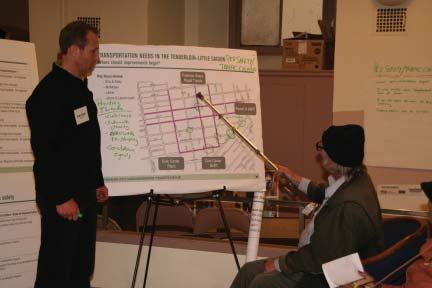
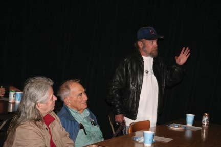
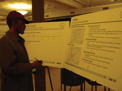
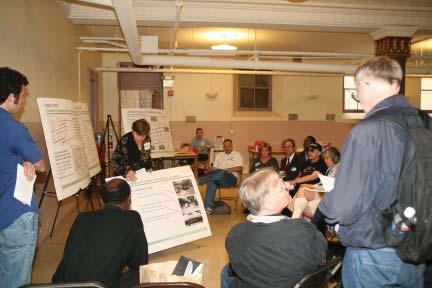
11 Figures 2-2 Workshop Activities
12 CHAPTER 3: GOALS AND NEEDS TENDERLOIN-LITTLE SAIGON NEIGHBORHOOD TRANSPORTATION PLAN MARCH 2007 CONTENTS 3.1 Needs Assessment Methodology Existing Conditions and Needs Assessment Summary of Project Goals CHAPTER 3 Goals and Needs This chapter summarizes the process for identifying the highest priority transportation needs in the Tenderloin, and reports the key findings. This effort resulted in community-derived goals to guide the development of improvement projects. The complete Existing Conditions and Needs Report is provided as Appendix Needs Assessment Methodology The Tenderloin-Little Saigon Neighborhood has been the subject of a number of previous studies that all identified similar transportation issues in the community. Key among these were the need for enhanced pedestrian safety, to slow and calm traffic traveling through the neighborhood, to improve the condition of the sidewalks, and to improve transit reliability. These needs were further developed through technical analysis and outreach. Technical steps to identify transportation needs included: 2000 U.S. Census data, used for demographic and land-use analysis; Travel patterns and mode shares estimated using the San Francisco County Transportation Authority s 3-1
")
13 San Francisco Travel Demand Model (SF-CHAMP); Field observations and inventories to assess streetscape, bus stop, and pedestrian conditions; Statewide Integrated Traffic Records System (SWITRS) data on pedestrian accidents to assess pedestrian safety and collisions; Transit schedules and performance data from Muni records; Muni ridership statistics from Muni s National Transit Database (NTD) Data for fiscal year 2005; Field observations and reviews of roadway geometry (e.g. number of lanes, directionality (one-way vs. two-way) and functional classification (arterial, collector) to document automobile circulation patterns; City-provided data on traffic volumes were independently verified by supplemental field observations; City s Synchro model of traffic operations, updated with newly collected traffic counts; and Site visits and city diagrams to catalog parking spaces and evaluate conditions. Figure 3-1 Percent of Households with Zero Vehicles 3.2 Existing Conditions and Needs Assessment The Tenderloin-Little Saigon area is unique among San Francisco neighborhoods. As a place, it is one of San Francisco s oldest neighborhoods, and its fine-grained streets provide a humane, pedestrian scale. Located next to San Francisco s urban core, it is home to a high density of housing, employment, and shops. The Tenderloin is unique in other ways. It is San Francisco s most ethnically diverse neighborhood, providing a home to many recent immigrants who give it a dynamic and rapidly evolving character. It is also one of its poorest communities, with low household incomes and the lowest car ownership rates in the City just 18% of households own an automobile (see Figure 3-1). To get around the City, Tenderloin residents are first and foremost pedestrians who use transit. Perhaps because of this, the key transportation needs that emerged from the community focused on improving transit and walking conditions. 3-2 SAN FRANCISCO COUNTY TRANSPORTATION AUTHORITY Tenderloin-Little Saigon Neighborhood Transportation Plan


14 Given the unique environment and transportation setting in this neighborhood, it is not surprising that the primary needs identified by the community focus on establishing a safe environment for diverse users including pedestrians, cyclists,and transit riders. One of the most critical needs identified by the community was the need to rebalance the transportation system to improve the pedestrian and transit environment, since most Tenderloin residents walk or take transit for nearly all their trips. The most critical needs include: Improve pedestrian safety. Accident rates are six times higher in the Tenderloin than in the city at large, and especially at intersections with Market Street and the intersection of McAllister and Leavenworth Streets. Improve transit service reliability and accessibility to low income individuals. The neighborhood is well served by multiple bus lines with frequent service, but buses are often crowded and bunched together in other words, service is unreliable. Residents are also concerned with the affordability of transit for low-income individuals. Reduce the speed of traffic through the neighborhood. The Tenderloin s multi-lane, oneway streets, many with excess capacity, encourage speeding and careless turn movements, endangering pedestrians and lowering the neighborhood s quality of life. Use the street environment as a tool to enhance security and improve the community experience. Narrow, cluttered, damaged and often barren sidewalks aren t just unattractive; sidewalk activity in confined spaces often forces pedestrians into the street. Improve Pedestrian Safety Figure 3-2 Locations of Pedestrian Accidents Figure 3-3 Sidewalk space is often constrained relative to demand As shown in Figure 3-2, the Tenderloin has a high rate of pedestrian incidents: order of magnitude estimates show that pedestrians are about six times more likely to be injured or killed by a car in the Tenderloin than in other areas of the City. Additionally, collisions are distributed throughout the neighborhood, indicating that traffic speeds are an issue in the neighborhood at large and not just at one or two hot spots. CHAPTER 3 Goals and Needs 3-3
 service.")

15 Figure 3-4 Reliability of Muni Routes Serving the Tenderloin Improve transit service reliability and accessibility Because of its central location, no neighborhood in San Francisco has a better supply of transit in terms of geographical coverage, frequency of service, regional connectivity, or amount of late night (i.e., 24 hour) service. In this sense, there is an abundance of transit in the Tenderloin. primary modes of travel, the streets themselves are generally designed to move large volumes of traffic going through the Tenderloin to the downtown core and the freeway system. The majority of the streets in the area are multi-lane one-way arterials designed to move cars as efficiently as possible to and from downtown or the freeway entrances and exits south of Market Street. The tension between the desires of residents living in this high-density, largely residential and mixed-use neighborhood, and the role its roads currently play for cars, is a common theme throughout this report. Community members repeatedly expressed concerns about speeding traffic and pedestrian conflicts, and the technical analysis found that in many locations there is excess auto capacity. Analysis of nine key intersections found afternoon-peak Level of Service (LOS) rankings at seven of them to be free flowing or Level of Service A - a very unusual result for an urban neighborhood with high volumes of traffic. The finding demonstrates the fact that cars move through the neighborhood very quickly, and indicates that the area is over-designed for automobile flow relative to other needs. The Tenderloin community s concerns with transit are not related to its supply, but rather to its performance. Many Tenderloin residents perceive Muni as unreliable and crowded, and data confirm these impressions. The 5-Fulton and the 38L-Geary Limited recently have surpassed Muni s load standards, and only about half of trips on those lines arrived according to scheduled headways. Every Tenderloin route except the 27-Bryant is less reliable than the Muni average. Unfortunately, the Tenderloin s location is related to transit performance problems. Transit routes are typically at their fullest when they arrive in the neighborhood. Routes that pass through the Tenderloin are among the longest in the City, so they have many opportunities to get off schedule before arriving in the Tenderloin, impacting their reliability. Moreover, it is likely that transit reliability degrades when traveling within the Tenderloin because of unpredictable delays caused by high volumes of vehicle, passenger, and pedestrian activity. Finally, Tenderloin residents frequently mention the expense of paying for transit trips as a significant concern, particularly since a fare increase in September Reduce The Speed Of Traffic Through The Neighborhood While the location, density, demographics and scale of the neighborhood support walking and transit as the 3-4 Use the street environment as a tool to enhance security and improve the community experience One of the primary concerns expressed by community members was the condition of sidewalks, their lack of cleanliness and state of disrepair. Desire for more pedestrian scale lighting was widely voiced. Additionally, because so much of the public right of way has been dedicated to automobile travel and parking, sidewalks in the Tenderloin may be too narrow for the high volume of pedestrian traffic they carry. Although considered pedestrian and streetscape amenities, the existing street furniture, trees, and transit shelters further constrain the effective width of the sidewalks. Finally, pedestrian conditions in the Tenderloin are degraded by the quantity of automobile traffic. SAN FRANCISCO COUNTY TRANSPORTATION AUTHORITY Tenderloin-Little Saigon Neighborhood Transportation Plan


16 Figure 3-5 Tree wells can collect refuse 3.3 Summary of Project Goals Figure 3-6 Community Prioritization of Needs Working with the community through stakeholder meetings, focus groups and public workshops, the high priority needs were translated into goals for the project. The relationships between transportation needs and project goals are summarized in Figure 3-7. Figure 3-7 Transportation Needs and Project Goals TRANSPORTATION NEED Improve Pedestrian Safety Rate of pedestrian collisions in the Tenderloin is several times higher than S.F. average Improve the street experience Sidewalks often feel dangerous, uncomfortable, unattractive Improve Transit Reliability Service is unreliable, passenger experience is uncomfortable, access is limited Reduce the Speed of Traffic Traffic is too fast CHAPTER 3 Goals and Needs PROJECT DEVELOPMENT GOAL Implement street designs that reduce likelihood of collisions Reduce vehicle speeds Increase pedestrian visibility Reduce conflicts between pedestrian and cars at intersections Reduce conflicts between pedestrians and bicyclists on the sidewalks Establish balance between pedestrian and auto traffic Use street design treatments to improve the look and feel of the street Provide ample space, light, and amenities for pedestrians Buffer pedestrians and transit passengers from traffic Improve bus stop quality Implement measures that improve the transit experience Increase reliability Increase user friendliness Reduce physical barriers to access, including to regional services such as BART or Golden Gate Improve access of low income individuals to Muni s Lifeline Fast Pass Implement street designs that slow down car traffic Reduce design speed of streets Reallocate mixed vehicle capacity to other street users transit, pedestrians, bicyclists 3-5
17 CHAPTER 4: PROJECTS DEVELOPMENT TENDERLOIN-LITTLE SAIGON NEIGHBORHOOD TRANSPORTATION PLAN MARCH 2007 CONTENTS 4.1 Project Development Process Technical Evaluation Methodology Overview of Project Alternatives Community Evaluation Pedestrian Safety Traffic Calming Transit Service Streetscape The issues, needs and goals articulated by the community during the outreach process guided the development of potential improvements. Projects were evaluated both based on technical analysis and community support, as well as their ability to be implemented in a relatively short time frame. The complete Projects Development and Evaluation Report is provided as Appendix Project Development Process The following table summarizes the process the project team used to develop potential projects. CHAPTER 4 Projects Development 4-1

18 Figure 4-1 Project Development Process Time Period March 2006 Step in Process TAC walking tour. Before the project team started in earnest to develop potential projects, the technical team led the TAC on a walking tour of the neighborhood. The walking tour was an opportunity to review general issues and goals raised by the community, to review problematic intersections and areas, and brainstorm possible solutions. The walking tour was well attended and followed the route shown on the map. Walking tours for community members were also part of the process. April 2006 Develop initial project ideas to respond to those needs/goals. After digesting the results of the community outreach process and the walking tour, the technical project team developed some preliminary project ideas. After reviewing these with the overall project team, including the CBOs, the technical project team developed the most promising ideas for presentation at the June 2006 community meeting. May 2006 Technical evaluation. Projects were evaluated for multimodal benefits and impacts according to the criteria described in Section 4.2. June 2006 Community meeting to present and prioritize potential projects. At the June 2006 community meeting, the project team presented potential projects to the community for feedback. This information, in addition to feedback gathered from additional outreach in input from the TAC, was used in the next step, refining the projects. Summer 2006 Fall 2006 Refine projects based on community feedback. Community, stakeholder, and TAC feedback was used to refine the proposed projects and to develop implementation phasing. The results of the community prioritization are described in the next chapter. 4-2 SAN FRANCISCO COUNTY TRANSPORTATION AUTHORITY Tenderloin-Little Saigon Neighborhood Transportation Plan
19 4.2 Technical Evaluation Methodology Prior to the June 2006 community workshop, the technical team evaluated potential transportation improvements. The technical evaluation documented likely benefits and impacts of projects and strategies using several criteria and quantitative and qualitative analysis. The results were presented at the community workshop to provide participants with a broad range of information to use in weighing priorities. 4.3 Overview of Project Alternatives The following tables summarize the range of projects, and their evaluation, that were considered to meet each of the study goals. Potential projects are summarized by the study goal they address, although many strategies may address more than one goal area. The evaluation addressed the following aspects of transportation in the Tenderloin: Transit operations and rider experience Pedestrian safety and access Streetscape environment Bicycle safety and access Traffic impacts and parking Cost Construction impacts Key evaluation results are presented in Section 4.3. Detailed results of the technical evaluation are provided in Appendix 3, the Projects Development and Evaluation Report. CHAPTER 4 Projects Development 4-3


 Red light running enforcement cameras No change to sidewalk width, sidewalk")

20 Pedestrian Safety Strategy Benefits Crossing Experience Sidewalk Conditions Impacts Parking Traffic Circulation Ease of Implementation Intersection curb bulbs Reduces crossing distance by 7-14 No change in traffic volumes or buffer from traffic. Reduces speed of right-turning vehicles. Increases sidewalk width at corners by 7. Reduces obstruction at corners. Minor impact on traffic circulation (slows down right-turning cars). Possible removal of 1 or 2 parking spaces where red curbs don t exist. Minor construction impact. Implementation: Near Term Visible crosswalks/ advance limit lines No change to sidewalk width, sidewalk obstructions, crossing distance or buffer from traffic. Reduce number of cars that don t yield to pedestrians. No traffic circulation, parking, or construction impacts. Implementation: Mid Term (standard City design to be developed over the next year through the Better Streets Master Plan) Red light running enforcement cameras No change to sidewalk width, sidewalk obstructions, crossing distance or buffer from traffic No change to traffic volumes. Reduces number of red light runners. No traffic circulation, parking, or construction impacts. Implementation: Near Term Pedestrian countdowns No change to sidewalk width, sidewalk obstructions, crossing distance, traffic volumes, traffic speeds, or buffer from traffic. Improves ease of crossing for pedestrians. No traffic circulation, parking, or construction impacts. Implementation: Near Term Bike lane or sharrows Reduces traffic crossing distance by Possible decrease to traffic speeds and volumes. Provides generous additional 5-6 buffer between pedestrians and traffic. Varies. Some traffic may divert to other streets. On many Tenderloin streets, bike lanes are unlikely to increase delays or congestion. No parking impacts designs recommended using mixed vehicle lanes for bike lanes rather than parking. No construction impacts. Implementation: Mid Term (requires further study) 4-4 SAN FRANCISCO COUNTY TRANSPORTATION AUTHORITY Tenderloin-Little Saigon Neighborhood Transportation Plan


21 Traffic Calming Strategy Narrow street or traffic lane width Bike lanes or bus only lanes Convert one way streets to two-way Retime signal progression for slower speed Benefits Average Traffic Speeds Traffic Volumes Reduce average travel speeds. Reduce average travel speeds. Reduced average travel speeds and slight reduction in traffic volumes. Reduce average travel speeds. Impacts Parking Traffic Circulation Ease of Implementation Potential slight increase in traffic on other routes due to lower travel speeds. No expected congestion or parking impacts. Implementation: Near Term, unless linked to other longer term changes Slight increase in traffic on other routes due to lower travel speeds. No expected congestion or parking impacts. Implementation: Mid Term (requires further study) Will alter circulation patterns for vehicle traffic, but is not likely to increase congestion or vehicle delays on most Tenderloin streets. The circulation links with SOMA streets to the south and the Van Ness corridor to the west require further study. No impact on parking. Implementation: Mid Term (requires circulation study) Slight increases in traffic on other routes due to lower travel speeds. No expected congestion or parking impacts. Implementation: Near Term, unless linked to longer term changes Reduce number of lanes Trees in the parking lane Reduce average travel speeds. Reduce average travel speeds. Slight increase in traffic on other routes due to lower travel speeds. No expected congestion or parking impacts. Implementation: Near Term, unless linked to other long term changes Slight increase in traffic on other routes due to lower travel speeds. No expected congestion. Removes about 4 parking spaces per block face. Requires community maintenance. Implementation: Near Term, unless linked to other long term changes CHAPTER 4 Projects Development 4-5


22 Transit Service Strategy Bus bulb outs Benefits Reliability Travel Times Waiting Experience Wayfinding Improve reliability. Decrease travel time. Improve waiting experience. No significant effect on wayfinding. Impacts Parking Traffic Circulation Ease of Implementation Minor traffic circulation impact. No parking impact unless length of bus stop is increased. Moderate construction impact. Implementation: Near Term Colorize Geary/O Farrell bus-only lane Improve reliability. Decrease travel time. No effect on waiting experience. Improve wayfinding. Minor traffic circulation impact. No parking impact. Moderate construction impact. Implementation: 5+ Years (paving moratorium) Reroute both directions on the same street Stop improvements (NextBus, shelters) Expand access to Lifeline Fast Pass Improve reliability, depending on the route. Decrease travel time (potentially 2.5 min. for the 5-Fulton) No effect on waiting experience. Significantly improve wayfinding. No effect on travel time, reliability, or wayfinding. Significantly improve waiting experience. Outreach to raise awareness of the Lifeline Fast Pass improves access to transit for low-income individuals. Minor traffic circulation impact. No parking impact. Implementation: Mid Term (requires circulation study) No traffic or parking impacts. Minor construction impact. Implementation: Near Term Implementation: Near Term 4-6 SAN FRANCISCO COUNTY TRANSPORTATION AUTHORITY Tenderloin-Little Saigon Neighborhood Transportation Plan


23 Streetscape Environment Strategy Pedestrian-scale and sidewalk lighting Benefits Street Identity Land Use Integration Connectivity Establishes recognizable theme for individual streets. Use a distinctive fixture design to brand the Tenderloin or Little Saigon neighborhood. New full spectrum light bulbs add more pleasing, less harsh light. Implement on a corridor basis that includes key destinations (Civic Center BART Station/ UN Plaza, Powell BART, Little Saigon) to improve connectivity within the Tenderloin and to adjacent neighborhoods. Impacts Parking Traffic Circulation Ease of Implementation No traffic or parking impacts. Minor construction impact. Implementation: Mid Term (requires standard City design, to be developed through Better Streets Master Plan) Widened sidewalks Trees in parking lane Widens buffer between traffic and pedestrians by about 3. Provides flexible sidewalk space that can be used by commercial and retail activities. Creates a double-row of trees that establishes a distinct streetscape identity. Reduces noise pollution on sidewalks by visually narrowing travel lanes and increasing buffer between pedestrians and traffic. Minor traffic circulation impact (slows traffic). No parking impact. Significant construction impact. Implementation: Near Term (unless linked to other long term changes) Minor traffic circulation impact (slows traffic). Removes about 4 parking spaces per block face. Moderate construction impact. Implementation: 1-2 Years; requires community maintenance Pedestrian-scale directional signs Implement on a corridor basis that includes key destinations (Civic Center BART Station/ UN Plaza, Powell BART, Little Saigon) to improve connectivity within the Tenderloin and to adjacent neighborhoods. No traffic or parking impacts. Negligible construction impact. Implementation: Near Term CHAPTER 4 Projects Development 4-7
24 4.4 Community Evaluation The community weighed in on preferred and top priority types of improvements through the survey (in Spanish, Vietnamese, and English) as well as through conversations at regularly scheduled community meetings, merchant interviews, and walking tours. PEDESTRIAN SAFETY A number of pedestrian safety improvements enjoyed broad support in the community: Countdown signals Visible crosswalks Corner bulbs Conversion of double-turn lanes to single-turn lanes Greater enforcement of traffic laws Additional signage Traffic Calming TRAFFIC CALMING Two of the potential traffic calming projects were also especially favored by the community: Wider sidewalks Retiming traffic signals for slower speeds Two traffic calming proposals were more controversial: Bicycle lanes. While survey respondents generally supported the concept, noting that Eddy and Ellis are flat streets connecting to bicycle routes beyond the neighborhood, many voiced reservations, including the possibility that skateboarders might use the lanes on hilly streets such as Jones. Conversion of one-way streets to two-way traffic. While the overwhelming majority of survey respondents supported the idea, community members raised a number of concerns. Arguments expressed for conversion included: Pedestrian safety Economic development Land-use benefits Improved sense of place Arguments against conversion included: Traffic congestion, including impacts on circulation beyond the neighborhood, in the larger street network Problems for left-turning vehicles Increased noise pollution from emergency vehicles consolidated onto two-way streets 4-8 (although the street most impacted by sirens is Hyde, which this study does not recommend as a candidate for conversion) Increased emergency response times As an alternative, some community members suggested reducing mixed-traffic capacity while retaining one-way operations. Overall, the sense that emerged was the need for a careful study of traffic calming alternatives, recommended by this plan. TRANSIT SERVICE Several ideas for improving transit service were popular among respondents: Increased affordability, including increased access to the Lifeline Fast Pass program for low-income riders Real-time bus arrival information Strategies to improve the cleanliness and comfort of bus stops, including bus bulbs and more widely available trash receptacles Another concept was more controversial: Consolidation of transit routes onto two-way streets. Arguments for re-routing included: Reduction of delays caused by circuitous routing Improved wayfinding Arguments against included: Greater pollution along streets with increased service STREETSCAPE Finally, the proposed streetscape improvement most widely supported was: Pedestrian-scale lighting Two proposals, meanwhile, received a mixed response: Trees in the parking lane. Concerns included: Trash collection Impacts on street cleaning Removal of parking spaces Conventional sidewalk tree-plantings. Concerns included: Reduction of light reaching the sidewalk Increased maintenance responsibilities SAN FRANCISCO COUNTY TRANSPORTATION AUTHORITY Tenderloin-Little Saigon Neighborhood Transportation Plan
25 CHAPTER 5: PRIORITY PROJECTS TENDERLOIN-LITTLE SAIGON NEIGHBORHOOD TRANSPORTATION PLAN MARCH 2007 CONTENTS 5.1 Potential Strategies and Projects Pedestrian Safety Traffic Calming Transit Service Streetscape Environment Phasing Strategy Potential Strategies and Projects This section outlines recommended improvements, categorized by goal area. Projects are further described, prioritized, and priority locations are illustrated in section 5.2, Phasing Strategy PEDESTRIAN SAFETY The community outreach process identified improving pedestrian safety as the primary goal of this transportation plan. Pedestrians in the Tenderloin are involved in collisions at a rate several times higher than the citywide average. The following list summarizes the improvements proposed, from simple low-cost maintenance issues to larger, transformative improvements. Improve Existing Crosswalks Repair Existing Worn Crosswalks Install Advance Limit Lines at Crosswalks Where Needed CHAPTER 5 Priority Projects 5-1
26 Develop and Install High-Visibility (Non-School Area) Standard Design Install Pedestrian Countdown Signals Install Permanent or Low-Cost Corner Bulbs Traffic Calming (see section 5.1.2) TRAFFIC CALMING Much of the auto traffic impacting the Tenderloin is not local traffic. The neighborhood s unique location adjacent downtown results in large volumes of through traffic to and from the Bay Bridge, the Financial District, and other areas of the City. Many of the roads are designed as auto-oriented, high-capacity facilities, with multiple lanes and one-way configurations. The residents of the area have expressed a strong desire to see the neighborhood s streets become more livable by shifting the balance away from maximizing auto throughput toward an improved environment for pedestrians and public transit. Slowing traffic speeds or traffic calming through the neighborhood is one way to achieve this goal. The following list summarizes the improvements proposed, from relatively low-cost strategies to larger, transformative improvements. Red Light Cameras Retime Traffic Signals Signal Mast Arms Comprehensive Traffic Calming and Circulation Study Study Converting Some Streets to Two-Way Operation. Candidate streets include the one way pairs Ellis / Eddy Streets and Leavenworth / Jones Streets. Develop Detailed Design for Reconfiguration of Some Intersections, especially McAllister/ Leavenworth and Golden Gate/Taylor/Market/ 6th. Sidewalk Widening Landscaping/Trees (see section 5.1.4) Figure 5-1 Potential Two-Way Configurations 5-2 SAN FRANCISCO COUNTY TRANSPORTATION AUTHORITY Tenderloin-Little Saigon Neighborhood Transportation Plan


27 Figure 5-2 Candidate Streets for Two-Way Conversion Figure 5-3 Potential Pedestrian Safety Improvements for Key Intersections CHAPTER 5 Priority Projects 5-3

28 5.1.3 TRANSIT SERVICE While some of the projects recommended below are related exclusively to transit, others would also serve to improve pedestrian conditions; bus bulbs, for example, would improve Muni reliability, provide additional sidewalk space, and reduce street crossing distances to improve pedestrian safety. Because transit riders begin and end every trip as a pedestrian, recommended pedestrian improvements will also make using transit easier and more pleasant. The following list summarizes the projects recommended to improve transit service. Improve Muni Performance in Neighborhood Reduce double parking on transit routes by reassessing the location of loading zones and of Parking Control Office enforcement patterns. Bus Bulbs Colorize Transit-Only Lanes Consolidate Route Operation on Two-Way Streets Improve Experience of Using Muni Install NextBus Muni Real-Time Arrival Information at Some Stops Bus Shelter Improvements, including increased maintenance and cleaning, larger shelters, and lighting improvements (see section 5.1.4). Improve Affordability of Muni for Low-Income Riders Improve Access to Muni s Lifeline Fast Passes Figure 5-4 Potential Consolidation of Transit Routes on Two-Way Streets 5-4 SAN FRANCISCO COUNTY TRANSPORTATION AUTHORITY Tenderloin-Little Saigon Neighborhood Transportation Plan

29 5.1.4 STREETSCAPE ENVIRONMENT The recommended improvements outlined below address specific needs articulated by members of the Tenderloin/Little Saigon community for improving their overall experience and security traveling through the neighborhood: improved lighting, increased sidewalk width and quality, and improved visual appearance of the streetscape. Streetscape components also contribute to broader goals, such as reducing traffic speeds and improving pedestrian safety. Figure 5-5 Pedestrian Scale and Sidewalk Lighting Options The following list summarizes the projects recommended to improve the streetscape environment. Street Furnishings Trash Receptacles Corner Bulb Outs Bus Shelters Lighting Mid-Term Lighting Improvement strategies, such as switching from High-Pressure Sodium to Metal Halide Lamps, or installing building-mounted fixtures. Install High-Quality Pedestrian-Oriented Light Fixtures Figure 5-6 Potential Approach to Planting Trees in Parking Lane Street Trees Street Trees in Corner Bulbouts (Select Species with Airy Canopies) Street Trees in Parking Lanes (Select Species with Airy Canopies) Sidewalks Sidewalk Repairs, including notifying property owners of required repairs, and replanting in or filling (e.g., with decomposed granite) empty tree wells. Sidewalk Widening Bus Bulbs CHAPTER 5 Priority Projects 5-5

30 5.2 Phasing Strategy The improvements recommended by the study team have been grouped and phased to achieve visible and meaningful improvements as quickly as possible and to have the right mix of area-wide and location-specific improvements. Some improvements are recommended for the entire neighborhood, while others are focused on primary pedestrian corridors or individual intersections. These short, medium, and long-term phases are summarized below, as well as in a table of improvements (Figure 5-8) and in maps of short, medium, and longterm improvements (Figures 5-9 to 5-11). Muni performance challenges are system-wide concerns that are being addressed by the City s Transit Effectiveness Project (TEP), which should issue recommendations in mid The transit improvements recommended as part of this study will make small improvements to Muni performance, but will greatly enhance the experience of using Muni in the Tenderloin. The recommended Traffic Calming and Circulation Study has the potential to alter Muni routing in the neighborhood and could result in a significant net benefit for Muni riders in the area. Figure 5-7 Streets Recommended for Traffic Calming Study 5-6 SAN FRANCISCO COUNTY TRANSPORTATION AUTHORITY Tenderloin-Little Saigon Neighborhood Transportation Plan
31 5.2.1 TIER 1 In order of priority, the short-term phasing strategy is to: Implement low-cost area-wide improvements as soon as possible. Some area-wide improvements are inexpensive, have dedicated funding sources, and can be done quickly. Pedestrian safety Install pedestrian countdown signals at intersections that do not yet have them Traffic calming Install a red light running camera on a commuter route through the Tenderloin Transit service Increase awareness and availability of subsidized Muni Fast Passes for low income residents Install NextBus signs at 38-Geary stops Enhance stop maintenance Streetscape environment Require property owners to repair damaged sidewalks and loading elevators Fill empty tree wells with decomposed granite or new trees to make level with sidewalks and prevent litter from collecting Fund and initiate additional studies. Some of the recommended larger-scale and/or more capital-intensive improvements require additional study. These studies should be initiated immediately so that recommendations can be implemented in the mid term. It is important to initiate these relatively small studies while the plan still has momentum within the community and City agencies. Otherwise, new outreach may have to be done, adding to their cost. Additional studies that are recommended include: Traffic Calming and Circulation Study. This study recommends several strategies to calm traffic, including conversion of some streets from one-way to two-way operation. Though this planning-level feasibility analysis suggests that such changes are feasible, change of this magnitude to the operation of the downtown street grid will require a more thorough analysis of impacts, benefits, and costs. A new study would also be relevant to MTA s Transit Effectiveness Project (TEP), as changes to the grid could benefit and/or impact Muni service design and quality. CHAPTER 5 Priority Projects Better Streets Master Plan Efforts. The Better Streets Master Plan (BSP), led by the MTA and the SF Planning Department, is developing standard approaches for a number of the recommendations developed for the Tenderloin. These include visible crosswalks; potential low-cost corner bulbouts; and pedestrian scale lighting treatments. Develop visible crosswalk standard. A new standard for a high-visibility crosswalk to be used in areas without schools will be developed by the BSP. Trial low-cost temporary corner bulbs. Constructing some trial corner bulbs in the first phase would allow them to be evaluated in the near term; if found successful, their design could be replicated throughout the Tenderloin and the City. Low cost corner bulbs could also be implemented more widely throughout the neighborhood in the medium term as a placeholder until funding becomes available for permanent poured concrete construction. Pedestrian-scale lighting treatments. The Better Streets Master Plan is developing an approach for providing more pedestrian scale lighting in neighborhoods TIER 2 With the exception of some projects dependent on further study, medium-term recommendations are highpriority improvements that are more capital-intensive. Securing funding for these projects will take time. Because it is likely that sufficient funding for all desired improvements will not be secured in the medium-term, these recommendations prioritize investment in the Tenderloin s primary pedestrian corridors, leaving similar improvements to other streets as recommendations for the long-term. Medium-term recommendations include: Implement low-cost improvements recommended by Better Streets Master Plan. The BSP is expected to develop a standard for non-school high-visibility crosswalks, as well as recommendations for providing pedestrian scale lighting. Once standards are adopted, they should be implemented in the Tenderloin at locations per the guidelines of the Better Streets Plan. Implement recommendations of Traffic Calming and Circulation Study. The cost of these improvements is yet unknown, but traffic calming strategies such as twoway street operations, tree plantings in parking lanes, and a potential east/west bicycle facility should be implemented as soon as possible. Recommended medium-term transit improvements are also dependent on this study and on the Transit 5-7
32 Effectiveness Project (TEP). Once Muni routings and stop locations in the Tenderloin are finalized, additional NextBus locations should be installed and sidewalk widening can be implemented in the mid term as funding is identified. These circulation changes will require legislative approvals. Widen sidewalks on core pedestrian corridors. Some sidewalk widening along primary pedestrian corridors is recommended. These widenings should be done in conjunction with the installation of traditional corner bulbs and new pedestrian lighting; these projects will cost less if built simultaneous than if built independently. Opportunities may exist to time these larger-scale improvements to coincide with DPW s scheduled reconstructions of Tenderloin streets, as well as to include their specifications in DPW construction bids, reducing costs TIER 3 Improvements recommended for the long-term are capital-intensive pedestrian projects such as sidewalk widening, corner bulbs, and tree plantings throughout the neighborhood. These projects could be implemented sooner if significant funding from an unexpected source were to become available TABLE AND MAPS Figures 5-8 to 5-11 clarify the emphasis of the recommended improvements: pedestrian safety and streetscapes. These correspond directly to the needs and goals identified by the Tenderloin community during the outreach process. Concentrating a complete suite of pedestrian improvements on Eddy, Ellis, Jones, and Leavenworth, or at least along the four blocks of Eddy between Leavenworth and the Powell BART/Muni Metro station, is part of a long-term funding strategy. It will be easier for the City to secure more funding for the same complete set of improvements for other area streets in the future if there is a concrete example that can be seen and experienced. Construct permanent corner bulbs. On core pedestrian corridors, traditional poured concrete corner bulbs are recommended. Where appropriate, these should be extended to create bus bulbs. Bulbs would not be designed until the routing recommendations of the TEP and Traffic Calming and Circulation Study are finalized, in order to maximize benefits for pedestrians and Muni riders. Significantly improve sidewalk lighting. Specific recommendations should be made following the guidelines of the BSP, prioritizing the core pedestrian corridors. 5-8 SAN FRANCISCO COUNTY TRANSPORTATION AUTHORITY Tenderloin-Little Saigon Neighborhood Transportation Plan
ABOUT THIS STUDY The Tenderloin-Little Saigon Community-Based Transportation Plan
 ABOUT THIS STUDY The Tenderloin-Little Saigon Community-Based Transportation Plan The Greater Tenderloin Community Study Milestones October Community based organizations (Tenderloin Housing Clinic and
Mission-Geneva Transportation Study Community Workshop 2 July 8, 2006
 Community Workshop 2 July 8, 2006 Small Group Workbook 1 Basic Improvements on Mission Street Streetscape. Pedestrian-scale lighting; landscaping; community art on utility boxes; more (possibly unique)
Outreach Approach RENEW SF served as the primary liaison with the North Beach community; the Chinatown. Executive Summary
 Executive Summary Executive Summary The Columbus Avenue Neighborhood Transportation Study s objective is to identify changes to transportation infrastructure and policies that could enhance the livability
WELCOME Mission-Geneva Transportation Study
 WELCOME Mission-Geneva Transportation Study Study Process and Schedule 2005 2006 Oct Nov Dec Jan Feb Mar Apr May Jun Jul Aug Sept Oct Task 2 Develop Outreach Plan Task 3 Document Existing Conditions/ Prioritize
Proposed. City of Grand Junction Complete Streets Policy. Exhibit 10
 Proposed City of Grand Junction Complete Streets Policy Exhibit 10 1 City of Grand Junction Complete Streets Policy Vision: The Complete Streets Vision is to develop a safe, efficient, and reliable travel
Van Ness Avenue Bus Rapid Transit (BRT) San Francisco Environment Commission Policy Committee
 San Francisco Environment Commission Policy Committee") Van Ness Avenue Bus Rapid Transit (BRT) San Francisco Environment Commission Policy Committee 04.30.12 Van Ness Avenue BRT Project Background Key north-south link in San Francisco s Rapid Transit network
Van Ness Avenue Bus Rapid Transit (BRT) San Francisco Environment Commission Policy Committee 04.30.12 Van Ness Avenue BRT Project Background Key north-south link in San Francisco s Rapid Transit network
Living Streets Policy
 Living Streets Policy Introduction Living streets balance the needs of motorists, bicyclists, pedestrians and transit riders in ways that promote safety and convenience, enhance community identity, create
Bicycle Master Plan Goals, Strategies, and Policies
 Bicycle Master Plan Goals, Strategies, and Policies Mobilizing 5 This chapter outlines the overarching goals, action statements, and action items Long Beach will take in order to achieve its vision of
Executive Summary Route 30 Corridor Master Plan
 Route Corridor Master Plan Project Overview The Route Corridor Master Plan is a coordinated multimodal transportation and land use plan for the entire stretch of Route through East Whiteland Township,
ALTERNATIVES SCREENING REPORT
 VAN NESS AVENUE BUS RAPID TRANSIT (BRT) ALTERNATIVES SCREENING REPORT Revised Draft, 3/28/08 San Francisco County Transportation Authority 1 Introduction The San Francisco County Transportation Authority
SAN FRANCISCO MUNICIPAL TRANSPORTATION AGENCY
 THIS PRINT COVERS CALENDAR ITEM NO. : 10.2 DIVISION: Sustainable Streets BRIEF DESCRIPTION: SAN FRANCISCO MUNICIPAL TRANSPORTATION AGENCY Adopting Conceptual Proposal for Streetscape Improvements to Broadway,
Arterial Transitway Corridors Study. Ave
 Arterial Transitway Corridors Study Ave January 2012 Arterial Transitway Corridors Study Overview Corridor Features and Demographics 11 study corridors, 95 route miles 86,000 daily rides and half of existing
Ann Arbor Downtown Street Plan
 1 Ann Arbor Downtown Street Plan Public Workshop #1 We know that. 2 Public right-of-way (streets, sidewalks, and alleys) make up 30% of the total District area of downtown. Streets need to provide mobility
Polk Streetscape Project
 What is this project? The Polk Streetscape Project is an effort to improve safety for everyone traveling on Polk Street between Union and McAllister streets. Also included in this project are paving, sewer
Multimodal Through Corridors and Placemaking Corridors
 68 Multimodal Through Corridors and Placemaking Corridors Corridors have different functions in a region. Some corridors are used to get smoothly and rapidly through a region or to get quickly to major
PEDESTRIAN ACTION PLAN
 ATTACHMENT 2 CITY OF SANTA MONICA PEDESTRIAN ACTION PLAN CITY OF SANTA MONICA PEDESTRIAN ACTION PLAN This page intentionally left blank EXECUTIVE SUMMARY CHAPTER 1 EXECUTIVE SUMMARY Setting the Stage
Pocatello Regional Transit Master Transit Plan Draft Recommendations
 Pocatello Regional Transit Master Transit Plan Draft Recommendations Presentation Outline 1. 2. 3. 4. What is the Master Transit Plan? An overview of the study Where Are We Today? Key take-aways from existing
Welcome! Thank you for joining us today for a Geary Rapid project open house. Geary Rapid Project. SFMTA.com/GearyRapid
 Welcome! Thank you for joining us today for a Geary Rapid project open house. Get the most out of this event: 1. Sign in and get your feedback sheet 2. Visit project information stations hosted by project
Existing Pedestrian Conditions. PSAC February 8, 2011
 Existing Pedestrian Conditions PSAC February 8, 2011 Contents 1. Project Background & Goals 2. Pedestrian Activity: Where people walk 3. Pedestrian Safety: The conditions people face Project Background
PEDALING FORWARD. A Glance at the SFMTA s Bike Program for SFMTA.COM
 PEDALING FORWARD A Glance at the SFMTA s Bike Program for 2017-2021 SFMTA.COM INTRODUCTION About This Booklet More people from all walks of life see their bicycle as a more convenient way to get where
CITY OF COCOA BEACH 2025 COMPREHENSIVE PLAN. Section VIII Mobility Element Goals, Objectives, and Policies
 CITY OF COCOA BEACH 2025 COMPREHENSIVE PLAN Section VIII Mobility Element Goals, Objectives, and Policies Adopted August 6, 2015 by Ordinance No. 1591 VIII MOBILITY ELEMENT Table of Contents Page Number
Better Market Street. Engineering, Maintenance & Safety Committee (EMSC) February 28, 2018
 February 28, 2018") Better Market Street Engineering, Maintenance & Safety Committee (EMSC) February 28, 2018 1 Market Street Market Street - San Francisco by rulenumberone2 2 Market Street is the... City s busiest pedestrian
Better Market Street Engineering, Maintenance & Safety Committee (EMSC) February 28, 2018 1 Market Street Market Street - San Francisco by rulenumberone2 2 Market Street is the... City s busiest pedestrian
Berkeley Strategic Transportation Plan A-76
 Berkeley Strategic Transportation Plan A-76 Appendices 1. A Team Effort 2. Where We ve Been A-11 Berkeley Strategic Transportation Plan Alameda County Transportation Plan Alameda County will be served
FOLSOM-HOWARD STREETSCAPE OVERVIEW
 FOLSOM-HOWARD STREETSCAPE OVERVIEW SoMa residents should have the same kinds of amenities that other neighborhoods have. The Folsom- Howard Streetscape Project will make SoMa more livable by making it
TRAVEL PLAN: CENTRAL EUROPEAN UNIVERSITY CAMPUS REDEVELOPMENT PROJECT TRAVEL PLAN. Central European University Campus Redevelopment Project.
 TRAVEL PLAN Central European University Campus Redevelopment Project Page 1 Table of Contents Introduction... 3 Background... 7 Building Users... 7 Transportation in Community Consultation... 7 Summary
Chapter 7. Transportation. Transportation Road Network Plan Transit Cyclists Pedestrians Multi-Use and Equestrian Trails
 Chapter 7 Transportation Transportation Road Network Plan Transit Cyclists Pedestrians Multi-Use and Equestrian Trails 7.1 TRANSPORTATION BACKGROUND The District of Maple Ridge faces a number of unique
Better Market Street Project Update. Urban Forestry Council September 17, 2014
 Better Market Street Project Update Urban Forestry Council September 17, 2014 Project Area Limits Better Market Street Schedule Market Street City s busiest transit corridor Over 85 buses per hour 14 surface
25th Avenue Road Diet Project A One Year Evaluation. Transportation Fund for Clean Air Project #05R07
 25th Avenue Road Diet Project A One Year Evaluation Transportation Fund for Clean Air Project #05R07 Submitted by: The San Francisco Municipal Transportation Agency Dan Provence May 22, 2009 EXECUTIVE
Replace century-old sewer & water pipes Pedestrian-scale sidewalk lighting
 PROJECT OVERVIEW The Masonic Avenue Streetscape Project is an effort to improve safety for everyone travelling on Masonic Avenue between Geary Boulevard and Fell Street. This project will bring a variety
Pedestrian Project List and Prioritization
 To: Kyle Wagenschutz, City of Memphis CC: From: Anne Conlon and John Cock, Alta Planning + Design Date: December, 2014 Re: Project List Development (Task 3.1-3.2) and Project List Prioritization (Task
WELCOME. Purpose of the Open House. Update you on the project. Present a draft recommended plan. Receive your input
 WELCOME Purpose of the Open House The Town of Smiths Falls has initiated the Beckwith Street Redevelopment Plan that includes the preparation of a streetscape functional design for the renewal of Beckwith
Appendix A-2: Screen 1 Alternatives Report
 Appendix A-2: Screen 1 Alternatives Report SCREEN 1 ALTERNATIVES REPORT Western & Ashland Corridors Bus Rapid Transit (BRT) Project Prepared for Chicago Transit Authority 567 West Lake Street Chicago,
Community Task Force July 25, 2017
 Community Task Force July 25, 2017 Welcome and Introductions Project Partners Regional Transportation District (RTD) Colorado Department of Transportation (CDOT) Denver Regional Council of Governments
Geary Corridor Bus Rapid Transit SFMTA Citizens Advisory Committee
 Geary Corridor Bus Rapid Transit SFMTA Citizens Advisory Committee Project Update SAN FRANCISCO COUNTY TRANSPORTATION AUTHORITY SAN FRANCISCO MUNICIPAL TRANSPORTATION AGENCY August 6, 2015 Project Overview
Bicycle and Pedestrian Advisory Committee (BPAC) November 21, 2013
 November 21, 2013") Bicycle and Pedestrian Advisory Committee (BPAC) November 21, 2013 OVERALL LAND USE CONCEPT Overall Broadway Valdez District: 95.5 acres (35.1 acres right-of ways + 60.4 acres developable land) Plan Subareas:
Bicycle and Pedestrian Advisory Committee (BPAC) November 21, 2013 OVERALL LAND USE CONCEPT Overall Broadway Valdez District: 95.5 acres (35.1 acres right-of ways + 60.4 acres developable land) Plan Subareas:
5. Automobile Circulation, Wayfinding and Signage
 5. Automobile Circulation, Wayfinding and Signage Policy: The City Center should have a balanced, safe, and interconnected circulation system that provides expanded travel opportunities for transit, pedestrian,
Chapter 2. Bellingham Bicycle Master Plan Chapter 2: Policies and Actions
 Chapter 2 Bellingham Bicycle Master Plan Chapter 2: Policies and Actions Chapter 2: Policies and Actions The Bicycle Master Plan provides a road map for making bicycling in Bellingham a viable transportation
City of Elizabeth City Neighborhood Traffic Calming Policy and Guidelines
 City of Elizabeth City Neighborhood Traffic Calming Policy and Guidelines I. Purpose: The City of Elizabeth City is committed to ensure the overall safety and livability of residential neighborhoods. One
APPENDIX A: Complete Streets Checklist DRAFT NOVEMBER 2016
 APPENDIX A: Complete Streets Checklist DRAFT NOVEMBER 2016 Complete Streets Checklist MetroPlan Orlando s Complete Streets Checklist is an internal planning tool for staff to further implementation of
CITY OF BLOOMINGTON COMPLETE STREETS POLICY
 CITY OF BLOOMINGTON COMPLETE STREETS POLICY POLICY OBJECTIVE: The City of Bloomington will enhance safety, mobility, accessibility and convenience for transportation network users of all ages and abilities,
Memo. Ocean Avenue Corridor Design Project Public Workshop #2 Summary
 Ocean Avenue Corridor Design Project Public Workshop #2 Summary The second public workshop for the Ocean Avenue Corridor Design Project was held on Wednesday, May 14, 2014 from, 6 to 8 pm at Lick Wilmerding
122 Avenue: 107 Street to Fort Road
 : 107 Street to Fort Road November 24, 2015 4:30 8:00 p.m. Meeting Purpose Summarize project work completed to date Share results of public input from Phase 1 Share the draft concept plan and proposed
Environment and Public Works Committee Presentation
 Mixed Use Centers Complete Streets Guidelines Project Environment and Public Works Committee Presentation December 10, 2008 Project Objectives: Conduct an inter-departmental and agency process to study
5. RUNNINGWAY GUIDELINES
 5. RUNNINGWAY GUIDELINES These guidelines should be considered collectively when making runningway decisions. A runningway is the linear component of the transit system that forms the right-of-way reserved
EXECUTIVE SUMMARY. Vision
 Vision Walking and bicycling in Salt Lake City will be safe, convenient, comfortable, and viable transportation options that connect people to places, foster recreational and economic development opportunities,
North Shore Transportation Improvement Strategy
 North Shore Transportation Improvement Strategy Preliminary, Near-term Recommendation 2016 April Transportation Improvement Strategy (TIS) Comprehensive and Analytical A multi-modal transportation strategy
Active Transportation Facility Glossary
 Active Transportation Facility Glossary This document defines different active transportation facilities and suggests appropriate corridor types. Click on a facility type to jump to its definition. Bike
San Jose Transportation Policy
 San Jose Transportation Policy Protected Intersections in LOS Policies to Support Smart Growth Presented by: Manuel Pineda City of San Jose Department of Transportation Bay Area Map San Francisco Oakland
o n - m o t o r i z e d transportation is an overlooked element that can greatly enhance the overall quality of life for the community s residents.
 N o n - m o t o r i z e d transportation is an overlooked element that can greatly enhance the overall quality of life for the community s residents. 84 Transportation CHAPTER 11 INTRODUCTION Transportation
Data Analysis February to March Identified safety needs from reported collisions and existing travel patterns.
 Welcome! Thank you for participating in today s Valencia Bikeway Improvements workshop. Data Analysis February to March Identified safety needs from reported collisions and existing travel patterns. Initial
Central Freeway and Octavia Circulation Study
 Central Freeway and Octavia Circulation Study Final Report Plans and Programs Committee San Francisco County Transportation Authority September 18, 2012 Presentation Outline Background and Study Purpose
Project Goal and Description. Why Broadway? Broadway SFMTA.COM/BROADWAY. The goal of the Broadway Safety Improvement
 PROJECT OVERVIEW Project Goal and Description The goal of the Broadway Safety Improvement d St Van Ness Ave Project is to improve safety and comfort for all who Franklin St Hyde St Octavia St Gough St
Philadelphia Bus Network Choices Report
 Philadelphia Bus Network Choices Report JUNE 2018 SEPTA Table of Contents Executive Summary...7 What if transit gave us more freedom?... 8 What is this report?... 8 The main conclusions... 9 What is happening
FINAL REPORT DECEMBER 2011
 FINAL REPORT DECEMBER 2011 AKNOWLEDGEMENTS SFMTA Staff Erin Miller, Project Manager Timothy Papandreou Jerry Robbins Pamela Stone Mike Sallaberry Chris Dimeling Emily Drennen Suzanne Chen-Harding San
Public Information Centre
 WELCOME Public Information Centre Father Tobin Road Lougheed Middle School - Library Wednesday November 7, 2012 7:00 p.m.to 9:00 p.m. Please sign in Neighbourhood Traffic Calming Guide Background The City
City of Wayzata Comprehensive Plan 2030 Transportation Chapter: Appendix A
 A1. Functional Classification Table A-1 illustrates the Metropolitan Council s detailed criteria established for the functional classification of roadways within the Twin Cities Metropolitan Area. Table
CONNECTING PEOPLE TO PLACES
 CONNECTING PEOPLE TO PLACES 82 EAST BENCH MASTER PLAN 07 Introduction The East Bench transportation system is a collection of slow moving, treelined residential streets and major arteries that are the
Van Ness Avenue BRT Overview and Scoping Process. Geary BRT CAC January 8, 2009
 Van Ness Avenue BRT Overview and Scoping Process Geary BRT CAC January 8, 2009 VAN NESS AVENUE S ROLE Identified in Prop K for BRT treatment Muni 47 and 49; 19 operates on Polk 20,000 daily riders on Van
CURBSIDE ACTIVITY DESIGN
 5 CURBSIDE ACTIVITY DESIGN This chapter provides design guidance for separated bike lanes adjacent to curbside activities including parking, loading and bus stops. Typical configurations are presented
Chapter 5. Complete Streets and Walkable Communities.
 Chapter 5. Complete Streets and Walkable Communities. 5.1 Description of Complete Streets. Cities throughout the world, and specifically the United States, are coming to embrace a new transportation and
Corpus Christi Metropolitan Transportation Plan Fiscal Year Introduction:
 Introduction: The Safe, Accountable, Flexible, Efficient Transportation Equity Act: A Legacy for Users (SAFETEA-LU) has continued the efforts started through the Intermodal Surface Transportation Efficiency
Roadways. Roadways III.
 Introduction 97 Roadway Design Principles 98 Safe Speeds 99 Optimizing of Street Space 00 Minimum Lane Widths in the City of Boston 02 Design Features that Reduce Operating Speeds 05 Travel Lanes Transit
HARRISON STREET/OAKLAND AVENUE COMMUNITY TRANSPORTATION PLAN
 HARRISON STREET/OAKLAND AVENUE Community Workshop #4: Draft Plan Review December 3, 2009 D E S I G N, C O M M U N I T Y & E N V I R O N M E N T INTRODUCTIONS Key Project Staff: Alisa Shen, Project Manager,
Vision: Traditional hamlet with an attractive business/pedestrian friendly main street connected to adjacent walkable neighborhoods
 N D. Focus Area II Vision: Traditional hamlet with an attractive business/pedestrian friendly main street connected to adjacent walkable neighborhoods Transit Road Focus Area II is located in the Hamlet
5 CIRCULATION AND STREET DESIGN
 5 CIRCULATION AND STREET DESIGN This chapter describes circulation and streetscape improvements proposed for the Northwest Chico Specific Plan Area. It includes detailed design specifications for existing
Planning Guidance in the 2012 AASHTO Bike Guide
 Planning Guidance in the 2012 AASHTO Bike Guide Presentation by: RJ Eldridge Peter Lagerwey August 22, 2012 WEBINAR 2: PLANNING GUIDANCE IN THE 2012 AASHTO BIKE GUIDE Today s Webinar Significant Updates
Chapter 3: Multi-Modal Circulation and Streetscapes
 CHAPTER 3: MULTI-MODAL CIRCULATION AND STREETSCAPES Chapter 3: Multi-Modal Circulation and Streetscapes Overview Streetscape improvements have already been completed for Depot Street between Main Avenue
SAN FRANCISCO MUNICIPAL TRANSPORTATION AGENCY
 THIS PRINT COVERS CALENDAR ITEM NO. : 11 DIVISION: Sustainable Streets BRIEF DESCRIPTION: SAN FRANCISCO MUNICIPAL TRANSPORTATION AGENCY Approving traffic modifications on Twin Peaks Boulevard between Christmas
Data Analysis February to March Identified safety needs from reported collisions and existing travel patterns.
 Welcome! Thank you for participating in today s Valencia Bikeway Improvements workshop. Data Analysis February to March Identified safety needs from reported collisions and existing travel patterns. Initial
C C C
 C-012-001 Thank you for your support for the creation of new public space and nonmotorized access between downtown and the waterfront through the Overlook Walk, the East-West Connections, and the Promenade.
City of Novi Non-Motorized Master Plan 2011 Executive Summary
 City of Novi Non-Motorized Master Plan 2011 Executive Summary Prepared by: February 28, 2011 Why Plan? Encouraging healthy, active lifestyles through pathway and sidewalk connectivity has been a focus
Caltrans Sloat Boulevard Pedestrian Safety Project Response to Community Questions, Comments & Concerns
 Caltrans Sloat Boulevard Pedestrian Safety Project Response to Community Questions, Comments & Concerns Revised: May 10, 2016 The California Department of Transportation (Caltrans) is planning various
City of Davenport CitiBus Public Transportation Study. April 2015
 City of Davenport CitiBus Public Transportation Study April 2015 Overview Project Background Key Findings CitiBus Service Allocation Policy Discussion 2 Project Background 3 About CitiBus Operates 17 routes
GIS Based Non-Motorized Transportation Planning APA Ohio Statewide Planning Conference. GIS Assisted Non-Motorized Transportation Planning
 The Purpose of GIS Assisted Network GIS Assisted Non-Motorized Transportation 2011 APA Ohio Statewide Conference Friday, 10:45 AM to Noon Focus on near-term projects wwwgreenwaycollabcom The purpose of
STONY PLAIN ROAD STREETSCAPE
 Jasper Place Revitalization Strategy: Vision The people involved in the Jasper Place Revitalization Strategy envision: Goal 1: Feeling safe in our community Create a community where feeling safe is common--where
PRINCE GEORGE S PLAZA METRO AREA PEDESTRIAN PLAN
 PRINCE GEORGE S PLAZA METRO AREA PEDESTRIAN PLAN May 28, 2008 Agenda Welcome and introductions Project overview and issue identification Planning context and strengths Design challenges and initial recommendations
Typical Rush Hour Commute. PennyforTransportation.com
 Typical Rush Hour Commute In the News Overview of the Plan Collaborative plan with projects in every community Prioritizing connectivity and congestion relief Dedicated transportation-specific funding;
Omaha s Complete Streets Policy
 Omaha s Complete Streets Policy (Adopted August 2015) VISION To create great places and enhance our quality of life, the City of Omaha will provide safe, accessible streets for all users. Complete Streets
Purpose and Need. Chapter Introduction. 2.2 Project Purpose and Need Project Purpose Project Need
 Chapter 2 Purpose and Need 2.1 Introduction The El Camino Real Bus Rapid Transit (BRT) Project (Project) would make transit and other transportation improvements along a 17.6-mile segment of the El Camino
Better Market Street Project. Project Update January 15, 2015
 Better Market Street Project Project Update January 15, 2015 Better Market Street Project Area Limits Market Street 2.2 Miles Mission Street Better Market Street Schedule Market Street City s busiest transit
Arterial Transitway Corridors Study
 Arterial Transitway Corridors Study February 2012 Arterial Transitway Corridors Study Overview Corridor Features and Demographics 11 study corridors, 95 route miles Routes: 86,000 daily rides and half
Hennepin County Bicycle and Pedestrian Planning
 Hennepin County Bicycle and Pedestrian Planning 1 Value of bicycle and sidewalk systems Safety Livability Mobility Health Personal Finances Economic Sustainability Clean Air Recreation Parking and congestion
Agenda. Overview PRINCE GEORGE S PLAZA METRO AREA PEDESTRIAN PLAN
 PRINCE GEORGE S PLAZA METRO AREA PEDESTRIAN PLAN May 28, 2008 Agenda Welcome and introductions Project overview and issue identification Planning context and strengths Design challenges and initial recommendations
RESOLUTION NO ?? A RESOLUTION OF THE CITY OF NEPTUNE BEACH ADOPTING A COMPLETE STREETS POLICY
 RESOLUTION NO. 2018-?? A RESOLUTION OF THE CITY OF NEPTUNE BEACH ADOPTING A COMPLETE STREETS POLICY WHEREAS, safe, convenient, and accessible transportation for all users is a priority of the City of Neptune
Chapter 14 PARLIER RELATIONSHIP TO CITY PLANS AND POLICIES. Recommendations to Improve Pedestrian Safety in the City of Parlier (2014)
") Chapter 14 PARLIER This chapter describes the current status and future plans for biking and walking in the City of Parlier. RELATIONSHIP TO CITY PLANS AND POLICIES The Parlier General Plan is the primary
Chapter 14 PARLIER This chapter describes the current status and future plans for biking and walking in the City of Parlier. RELATIONSHIP TO CITY PLANS AND POLICIES The Parlier General Plan is the primary
Active Transportation Rail to River Corridor. Community Meeting - Segment A
 Active Transportation Rail to River Corridor Community Meeting - Segment A June 29, 2017 Tonight s Agenda > Open House (30 min) > Welcome / Project Overview > Presentation of 30% Design Refinements > Next
CHAPTER 7.0 IMPLEMENTATION
 CHAPTER 7.0 IMPLEMENTATION Achieving the vision of the Better Streets Plan will rely on the ability to effectively fund, build and maintain improvements, and to sustain improvements over time. CHAPTER
MASONIC AVENUE STREET DESIGN STUDY Community Workshop 2. Masonic Ave Street Design Study Community Workshop 2 August 10, 2010
 Masonic Ave Street Design Study Community Workshop 2 August 10, 2010 Introduction MASONIC AVENUE STREET DESIGN STUDY Community Workshop 2 SF Municipal Transportation Agency Javad Mirabdal, Project Manager
5/31/2016 VIA . Arwen Wacht City of Sacramento Community Development Department 300 Richards Blvd., 3 rd Floor Sacramento, CA 95811
 5/31/2016 VIA EMAIL Arwen Wacht City of Sacramento Community Development Department 300 Richards Blvd., 3 rd Floor Sacramento, CA 95811 RE: El Pollo Loco (P16-028) Dear Ms. Wacht: WALKSacramento has reviewed
City of San Diego Vision Zero Draft Strategic Plan FY 2017
 City of San Diego Vision Zero Draft Strategic Plan FY 2017 Engineering Objective: To develop and implement a strategy that employs best planning, design and engineering practices. Background: Over the
A CHANGING CITY. of Edmonton, it is essential that it reflects the long-term vision of the City.
 A CHANGING CITY By the year 2040, Edmonton will be home to more than 1 million people. To accommodate growth and support a healthy and compact city, we need a new approach to development/redevelopment
Bikeway action plan. Bicycle Friendly Community Workshop March 5, 2007 Rochester, MN
 Bikeway action plan Summary The was held on March 5, 2007 at the Rochester Mayo Civic Center. The workshop was hosted by Rochester-Olmsted County Planning Department in collaboration with the League of
WELCOME Public Information Centre
 WELCOME Public Information Centre Fernforest Drive Brampton Soccer Centre Community Room #2 Tuesday January 19, 2016 6:30 p.m.to 9:00 p.m. Please sign in Neighbourhood Traffic Calming Guide Background
Why Zone In on Speed Reduction?
 Learn it. Do it. Live it! SPEED REDUCTION IN THE ZONE Why Zone In on Speed Reduction? Speeding is a serious issue that plays a major role in the risk of serious injury and pedestrian fatality in a crash.
Richmond Connects Visioning Update
 Richmond Connects Visioning Update To date there have been four elements of the visioning process: Vision20 Night at Byrd Theatre on May 3rd Advisory Committee Meeting on May 12 th Public Visioning Workshop
Tonight is for you. Learn everything you can. Share all your ideas.
 Strathcona Neighbourhood Renewal Draft Concept Design Tonight is for you. Learn everything you can. Share all your ideas. What is Neighbourhood Renewal? Creating a design with you for your neighbourhood.
Physical Implications of Complete Streets Policies
 Presentation Overview Physical Implications of Complete Norm Cox, ASLA, LLA Landscape Architect Ann Arbor, Michigan, 10:45 to Noon What Are Complete Streets? What Matters to Bicyclists and Pedestrians
ABOUT THIS OPEN HOUSE
 ABOUT THIS OPEN HOUSE Welcome, and thanks for joining us today for the Folsom-Howard Near-Term Project! The purpose of today s open house is to: Understand how the near-term project ties into the larger
County of Greenville South Carolina. Traffic Calming Program Neighborhood Traffic Education Program and Speed Hump Program
 County of Greenville South Carolina Traffic Calming Program Neighborhood Traffic Education Program and Speed Hump Program (rev) August 2008 I. PURPOSE The potential negative impacts from vehicular traffic
Draft Traffic Calming Policy Paper
 Draft Traffic Calming Policy Paper What is Traffic Calming The term traffic calming is defined differently throughout the United States. The Institute of Transportation Engineers, an international educational