Sustainability and Livability
|
|
|
- Henry Atkins
- 6 years ago
- Views:
Transcription

1 Implementing Abu Dhabi s 21 st Century Vision for Sustainability and Livability

2 Global Context Emirate of Abu Dhabi is the largest of seven nation-states that make up the United Arab Emirates. Abu Dhabi controls most of the nation s oil wealth. Abu Dhabi City is the capital city of the Emirate. Abu Dhabi seeks to be known as the cultural capital of the Middle East.


3 Abu Dhabi s Early Days - A Small Seaside Fishing Village


4 Villagers walked from place to place... This was only about 40 to 50 years ago


5 Then


6 Things began to change very rapidly

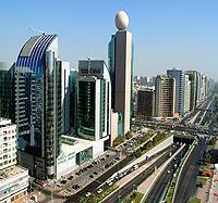
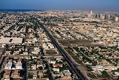

7 Phenomenal growth and change 1960s through the present


8 Same problems as western cities with sprawling, unchecked growth
9 It was time for a new vision Abu Dhabi Plan 2030
10


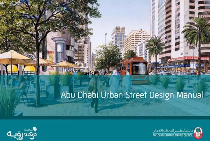
11 Why a Street Design Manual? Implementing Plan 2030 Creating a World Class City Enhancing livability, health, and sustainability Making the urban environment better for next generations


12 Why a Street Design Manual? Providing better urban design guidance to improve street environments


13 Why a Street Design Manual? Helping people cross the street safely

14 Why a Street Design Manual? Minimizing hazards for pedestrians


15 Why a Street Design Manual? Providing accessible sidewalks for all users


16 Why a Street Design Manual? Reducing street clutter


17 Learning from Best Practices around the World


18 Collaborative Approach: Technical Advisory Committee The Urban Planning Council worked together with: Department of Transport Department of Municipal Affairs: Al Ain Al Gharbia Abu Dhabi Civil Defense Traffic Police External Technical Experts
19 Abu Dhabi Urban Street Design Manual Key Principles / Approach

20 Strong Emphasis on Safety

21 Strong Emphasis on Safety

22 Strong Emphasis on Safety

23 Strong Emphasis on Safety

24 Strong Emphasis on Safety
25 Lane Widths Studies on lane widths report mixed results, with some studies finding wider lanes are safer, and other finding wider lanes are more dangerous. In general, safety decreases wider than 3.5 m. Narrower lanes result in lower speeds, which tend to result in better safety in urban contexts. Sources: Clark, 1985; Dumbaugh, 2005; Farouki and Nixon, 1976; Fitzpatrick et al., 2001; Gattis and Watts, 1999; Harwood, 1990; Hauer, 1999; Heimbach et al., 1983; Lee and Mannering, 1999; Noland and Oh, 2004; Zegeer, Deen and Mayes,1981.

26 Number of Lanes Studies consistently find that adding lanes increases crashes, while eliminating lanes though road diet projects decreases crashes. Sources: Dumbaugh, 2005; Harwood, 1986; Harwood,1990; Huang, Stewart, and Zegeer, 2001; Knapp and Giese, 2001; Milton and Mannering, 1998; Noland and Oh, 2004; Sawalha and Sayed (2001); Vitalano and Held 1991.

27 Land Use Context

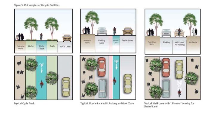
28 Typologies - Combinations

29 Elements of the Street

30 Coded to Land Use and Street Type

31 Example Cross Sections
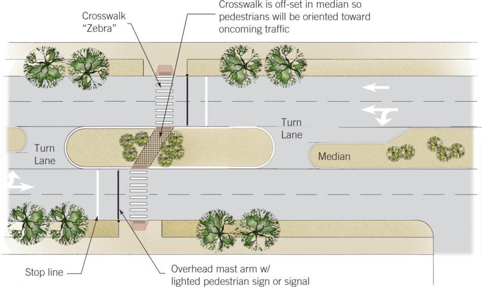
32 Abu Dhabi Urban Street Design Manual Design Toolbox

33 Pedestrian Realm Composition

34 Pedestrian Realm Composition
35 Bicycle Facilities


36 Metro Tram Bus Rapid Transit Advantages and Disadvantages Of Center, Side, and Sidewalk- Running Tram High quality Metro station entrance Paris, France High quality tram station Minneapolis, USA


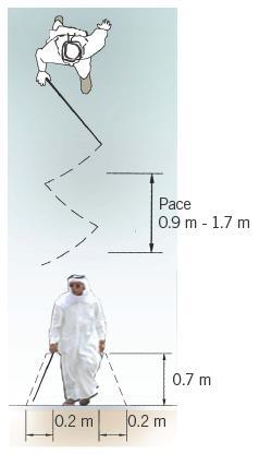
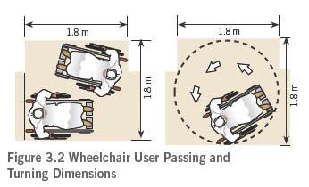
37 Bus Taxis Private Transit Comparison of Near, Far, and Midblock Bus Stops Bus Rapid Transit on boulevard Mexico City, Mexico

38 Examples to Fit Land Use and Street Types
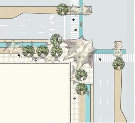
39 Pedestrian Crossings


40 Crossing Design Guidelines for Installing Pedestrian Midblock Crossings
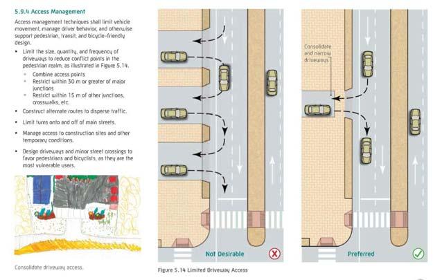
41 Access Management


42 Driveway Design Driveways designed as a curb cut, not a junction Washington, USA Stop sign for drivers at pedestrian crossing Washington, USA Midblock crossing requires curb ramps and marked crosswalk Abu Dhabi Curb Heights Slopes & Grade

43 Curb Ramps Ramps are aligned with crosswalks New Construction Ramp Design Permissible exception if 8.33% slope is technically infeasible

44 Accessibility / Urban Braille
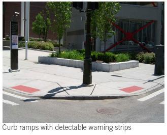
45 Accessibility/Urban Braille

46 Shade and Streetscape Treatments
47 Shade Structures/Placement

48 Streetscape Furnishings

49 Streetscape Furnishings

50 Weblink to Manual: urban-street-design-manual.aspx Shukran! (Thank You!)
* With exceptions for topography or special circumstances.
 Block Length Limits* Salem, OR 600 ft (180 m) Portland, OR Davidson, NC Raleigh, NC Fort Collins, CO Boulder, CO 530 ft 600 ft 1,500 ft Max block size (7-12 acres) 350 ft (by practice) * With exceptions
Agenda. Overview PRINCE GEORGE S PLAZA METRO AREA PEDESTRIAN PLAN
 PRINCE GEORGE S PLAZA METRO AREA PEDESTRIAN PLAN May 28, 2008 Agenda Welcome and introductions Project overview and issue identification Planning context and strengths Design challenges and initial recommendations
Transportation Planning Division
 Transportation Planning Division Presentation Outline Study Tasks Recap of Previous Meetings Data Collected Focus Areas within Study Limits Design Principles Tool Box Recommended Concepts Schedule Moving
PRINCE GEORGE S PLAZA METRO AREA PEDESTRIAN PLAN
 PRINCE GEORGE S PLAZA METRO AREA PEDESTRIAN PLAN May 28, 2008 Agenda Welcome and introductions Project overview and issue identification Planning context and strengths Design challenges and initial recommendations
Designing Complete Streets: What you need to know
 Designing Complete Streets: What you need to know Getting from this to this. Continuous sidewalk Buffer w/trees Bicycle lane Raised median Buildings close to the street Flexibility in design Design and
Proposed. City of Grand Junction Complete Streets Policy. Exhibit 10
 Proposed City of Grand Junction Complete Streets Policy Exhibit 10 1 City of Grand Junction Complete Streets Policy Vision: The Complete Streets Vision is to develop a safe, efficient, and reliable travel
Complete Streets 101: The Basics
 Complete Streets 101: The Basics Michigan Municipal League - Capital Conference March 21, 2017 Chip Smith, AICP - Senior Planner - Wade Trim Inc. and City Council member City of Ann Arbor 2017 MML Capital
10.0 CURB EXTENSIONS GUIDELINE
 10.0 CURB EXTENSIONS GUIDELINE Road Engineering Design Guidelines Version 1.0 March 2017 City of Toronto, Transportation Services City of Toronto Page 0 Background In early 2014, Transportation Services
Road Diets FDOT Process
 Florida Department of TRANSPORTATION Road Diets FDOT Process Humberto Castillero, PE, PTOE Roadway Design Office Purpose of Guide Develop a statewide lane elimination review process Balance state & local
Off-road Trails. Guidance
 Off-road Trails Off-road trails are shared use paths located on an independent alignment that provide two-way travel for people walking, bicycling, and other non-motorized users. Trails specifically along
CURBSIDE ACTIVITY DESIGN
 5 CURBSIDE ACTIVITY DESIGN This chapter provides design guidance for separated bike lanes adjacent to curbside activities including parking, loading and bus stops. Typical configurations are presented
REGIONAL BICYCLE AND PEDESTRIAN DESIGN GUIDELINES
 REGIONAL BICYCLE AND PEDESTRIAN DESIGN GUIDELINES November 16, 2011 Deb Humphreys North Central Texas Council of Governments Bicycle and Pedestrian Advisory Committee Snapshot of the Guide 1. Introduction
Oakland Pedestrian Master Plan Oakland Pedestrian Plan Draft Recommendations Chapter Outline
 EISEN LETUNIC T R A N S P O R T A T I O N, ENVIRO N M E N TA L A N D URBAN PLANNIN G MEMORANDUM To Oakland Pedestrian Plan Technical Advisory Committee & Pedestrian Advisory Group From Victoria Eisen Date
Complete Streets. Designing Streets for Everyone. Sarnia
 Complete Streets Designing Streets for Everyone Sarnia Complete Streets ~ Sarnia ~ 2018 Introduction Our City is made up of a network of streets that we use to go for a walk, cycle to work, drive to the
Coordinating Land Use and Transportation (and Traffic Safety)
") Coordinating Land Use and Transportation (and Traffic Safety) Design for Health University of Minnesota Reid Ewing National Center for Smart Growth Give Them War Stories and Codes Well Maybe Not Considering
Coordinating Land Use and Transportation (and Traffic Safety) Design for Health University of Minnesota Reid Ewing National Center for Smart Growth Give Them War Stories and Codes Well Maybe Not Considering
EMPHASIS AREA 1: PEDESTRIANS
 EMPHASIS AREA 1: PEDESTRIANS A pedestrian is seriously injured or killed every 3 days on Toronto s roads. Pedestrian collisions involve any person that is not riding in a vehicle or on a bicycle. 26% OF
SAN FRANCISCO MUNICIPAL TRANSPORTATION AGENCY
 THIS PRINT COVERS CALENDAR ITEM NO.: 13 DIVISION: Sustainable Streets BRIEF DESCRIPTION: SAN FRANCISCO MUNICIPAL TRANSPORTATION AGENCY Endorsing the Planning Department s 2014 Update to the conceptual
Hennepin Avenue Reconstruction Washington Avenue to 12 th Street
 CITY OF MINNEAPOLIS Hennepin Avenue Reconstruction Washington Avenue to 12 th Street April 2016 1 Upcoming Opportunities Public Meeting #2 April 25, 2016 Minneapolis Central Library Doty Board Room Repeat
APPENDIX A: Complete Streets Checklist DRAFT NOVEMBER 2016
 APPENDIX A: Complete Streets Checklist DRAFT NOVEMBER 2016 Complete Streets Checklist MetroPlan Orlando s Complete Streets Checklist is an internal planning tool for staff to further implementation of
NJDOT Complete Streets Checklist
 Background The New Jersey Department of Transportation s Complete Streets Policy promotes a comprehensive, integrated, connected multi-modal network by providing connections to bicycling and walking trip
PEDESTRIAN ACTION PLAN
 ATTACHMENT 2 CITY OF SANTA MONICA PEDESTRIAN ACTION PLAN CITY OF SANTA MONICA PEDESTRIAN ACTION PLAN This page intentionally left blank EXECUTIVE SUMMARY CHAPTER 1 EXECUTIVE SUMMARY Setting the Stage
Complete Streets Policy DAVID CRONIN, P.E., CITY ENGINEER
 Complete Streets Policy DAVID CRONIN, P.E., CITY ENGINEER Complete Streets City Commission adopted a Complete Streets policy in 2012 Complete Streets are road networks that are designed for all users:
Omaha s Complete Streets Policy
 Omaha s Complete Streets Policy (Adopted August 2015) VISION To create great places and enhance our quality of life, the City of Omaha will provide safe, accessible streets for all users. Complete Streets
AMATS Complete Streets Policy
 AMATS Complete Streets Policy Table of Contents: Section 1. Definition of Complete Streets Section 2. Principles of Complete Streets Section 3. Complete Streets Policy Section 4. Consistency Section 5.
TOWN OF PORTLAND, CONNECTICUT COMPLETE STREETS POLICY
 TOWN OF PORTLAND, CONNECTICUT COMPLETE STREETS POLICY I. VISION, GOALS & PRINCIPLES VISION To improve the streets of Portland making them safer and more accessible for all users including pedestrians,
Mission-Geneva Transportation Study Community Workshop 2 July 8, 2006
 Community Workshop 2 July 8, 2006 Small Group Workbook 1 Basic Improvements on Mission Street Streetscape. Pedestrian-scale lighting; landscaping; community art on utility boxes; more (possibly unique)
Making Phoenix Streets Complete. City of Phoenix Complete Streets Initiative
 Making Phoenix Streets Complete City of Phoenix Complete Streets Initiative City of Phoenix Planning Commission March 2014 Presentation Outline What are Complete Streets? Benefits of Complete Streets Complete
The DC Pedestrian Master Plan
 The DC Pedestrian Master Plan September 28, 2010 George Branyan Pedestrian Program Coordinator District Department of Transportation Presentation Agenda Scope of the Plan Methodology Recommendations Implementation
ACTIVE TRANSPORTATION
 ACTIVE TRANSPORTATION Mobility 2040 Supported Goals Improve the availability of transportation options for people and goods. Support travel efficiency measures and system enhancements targeted at congestion
Transportation Planning Division
 Transportation Planning Division Presentation Outline Study Tasks Recap of Previous Meeting Stakeholder Interviews Data Collection Design Principles Tool Box Recommendations Schedule Moving Forward North
Item to be Addressed Checklist Consideration YES NO N/A Required Description Complete Streets Guidelines
 Passaic County Complete Streets Checklist - Concept Development Project Name Item to be Addressed Checklist Consideration YES NO N/A Required Description Complete Streets Guidelines Existing Plans Have
APPENDIX A BICYCLE, PEDESTRIAN, AND TRANSIT ASSESSMENT WORKSHEET. B. Subdivision/Site Development Plan/Grading Permit Name and Number:
 APPENDIX A BICYCLE, PEDESTRIAN, AND TRANSIT ASSESSMENT WORKSHEET I. GENERAL INFORMATION A. Project name: B. Subdivision/Site Development Plan/Grading Permit Name and Number: C. Project address: D. Project
Better Market Street. Engineering, Maintenance & Safety Committee (EMSC) February 28, 2018
 February 28, 2018") Better Market Street Engineering, Maintenance & Safety Committee (EMSC) February 28, 2018 1 Market Street Market Street - San Francisco by rulenumberone2 2 Market Street is the... City s busiest pedestrian
Better Market Street Engineering, Maintenance & Safety Committee (EMSC) February 28, 2018 1 Market Street Market Street - San Francisco by rulenumberone2 2 Market Street is the... City s busiest pedestrian
City of Albert Lea Policy and Procedure Manual 4.10 ALBERT LEA CROSSWALK POLICY
 4.10 ALBERT LEA CROSSWALK POLICY PURPOSE: Pedestrian crosswalks are an integral part of our transportation infrastructure. To be effective and promote safety, marked crosswalks must be installed after
DEPARTMENT OF ENVIRONMENTAL SERVICES. North Harrison Street (Lee Highway to Little Falls Road) Comparative Analysis. Prepared for:
 Comparative Analysis. Prepared for:") DEPARTMENT OF ENVIRONMENTAL SERVICES North Harrison Street (Lee Highway to Little Falls Road) Comparative Analysis Prepared for: Arlington County Department of Environmental Services 2100 Clarendon Boulevard,
DEPARTMENT OF ENVIRONMENTAL SERVICES North Harrison Street (Lee Highway to Little Falls Road) Comparative Analysis Prepared for: Arlington County Department of Environmental Services 2100 Clarendon Boulevard,
DOWNTOWN MIAMI PEDESTRIAN PRIORITY ZONE
 DOWNTOWN MIAMI PEDESTRIAN PRIORITY ZONE AUGUST 6, 2013 DOWNTOWN MIAMI BY THE NUMBERS more than 200,000 people live, work, and play here every day is home to more than 1,000 events each year hosts more
Telegraph Avenue Complete Streets DRAFT Recommendations. Oakland Public Works Department September 11 and 13, 2014 Open Houses
 Telegraph Avenue Complete Streets DRAFT Recommendations Oakland Public Works Department September 11 and 13, 2014 Open Houses Presentation Overview What are complete streets? What problem are we trying
Access Management in the Vicinity of Intersections
 Access Management in the Vicinity of Intersections FHWA-SA-10-002 Technical Summary Photo: Ralph Bentley (used with permission) 0 Access Management is: The design, implementation and management of entry
MAYFIELD ROAD CORRIDOR MULTIMODAL TRANSPORTATION PLAN. Public Workshop
 MAYFIELD ROAD CORRIDOR MULTIMODAL TRANSPORTATION PLAN Public Workshop 06.06.18 AGENDA Project Process & Schedule Document Review Summary Project Goals Initial Findings Concept Development Next Steps PROJECT
City of Elizabeth City Neighborhood Traffic Calming Policy and Guidelines
 City of Elizabeth City Neighborhood Traffic Calming Policy and Guidelines I. Purpose: The City of Elizabeth City is committed to ensure the overall safety and livability of residential neighborhoods. One
Long Island Rail Road Expansion Project Floral Park to Hicksville
 Long Island Rail Road Expansion Project Floral Park to Hicksville Final Environmental Impact Statement Appendix 1-D Complete Streets Policy Checklist April 2017 0902ML PIN: Project Location: 18A-4 Floral
Pedestrian and Bicycle Conditions
 Pedestrian and Bicycle Conditions Geary Citizens Advisory Committee May 8, 2014 SAN FRANCISCO COUNTY TRANSPORTATION AUTHORITY SAN FRANCISCO MUNICIPAL TRANSPORTATION AGENCY Topics Pedestrian Conditions
Bicycle and Pedestrian Advisory Committee (BPAC) November 21, 2013
 November 21, 2013") Bicycle and Pedestrian Advisory Committee (BPAC) November 21, 2013 OVERALL LAND USE CONCEPT Overall Broadway Valdez District: 95.5 acres (35.1 acres right-of ways + 60.4 acres developable land) Plan Subareas:
Bicycle and Pedestrian Advisory Committee (BPAC) November 21, 2013 OVERALL LAND USE CONCEPT Overall Broadway Valdez District: 95.5 acres (35.1 acres right-of ways + 60.4 acres developable land) Plan Subareas:
EXECUTIVE SUMMARY November 2016
 EXECUTIVE SUMMARY November 2016 Purpose The New Jersey Bicycle and Pedestrian Master Plan presents a vision, goals, and strategies to achieve a transportation system in which walking and bicycling are
complete streets design and construction standards public primer City of Edmonton
 complete streets design and construction standards public primer City of Edmonton introduction Complete Streets are streets for everyone: people who walk, wheel, bike, take transit, or drive. They are
Better Market Street Project Update. Urban Forestry Council September 17, 2014
 Better Market Street Project Update Urban Forestry Council September 17, 2014 Project Area Limits Better Market Street Schedule Market Street City s busiest transit corridor Over 85 buses per hour 14 surface
N. Frederick Street to N. Manchester Street
 November 20, 2014 N. Frederick Street to N. Manchester Street Goals and Summary, November 2007 Map, December 2007 Bicycle Element, July 2008 Pedestrian Element, July 2008 Demand and System Management,
EXECUTIVE SUMMARY. Vision
 Vision Walking and bicycling in Salt Lake City will be safe, convenient, comfortable, and viable transportation options that connect people to places, foster recreational and economic development opportunities,
Welcome to the Quebec Alternatives Analysis Public Meeting
 Welcome to the Public Meeting Please sign in. Public Comment Please fill out a comment card and tell us what you think. Check back or comment any time at: www.quebecalternatives.com Project Area Technical
David Hung, Associate Planner City of Sacramento Community Development Department 300 Richards Boulevard, 3 rd Floor Sacramento, CA
 June 13, 2016 VIA EMAIL David Hung, Associate Planner City of Sacramento Community Development Department 300 Richards Boulevard, 3 rd Floor Sacramento, CA 959811 RE: Fire Station 14 (DR16-128) Dear Mr.
North Avenue Corridor Study
 North Avenue Corridor Study Advisory Committee Meeting #6 July 1, 2014 Agenda Concept Revisions based on Advisory Committee feedback Review of New Concept Scoring & Costs Concept Discussion/Questions Voting:
Pine Hills Road Pedestrian/Bicycle Safety Study Board of County Commissioners Work Session
 Pine Hills Road Pedestrian/Bicycle Safety Study Board of County Commissioners Work Session February 20, 2018 Meeting Agenda Study Overview Existing Conditions Access Management Potential Gateway Features
A CHANGING CITY. of Edmonton, it is essential that it reflects the long-term vision of the City.
 A CHANGING CITY By the year 2040, Edmonton will be home to more than 1 million people. To accommodate growth and support a healthy and compact city, we need a new approach to development/redevelopment
Welcome. If you have any questions or comments on the project, please contact:
 Welcome This drop-in public open house is intended to provide information about the Bay Street bike lanes project. This project proposes a dedicated cycling facility along Bay Street between Aberdeen Avenue
RESOLUTION NO ?? A RESOLUTION OF THE CITY OF NEPTUNE BEACH ADOPTING A COMPLETE STREETS POLICY
 RESOLUTION NO. 2018-?? A RESOLUTION OF THE CITY OF NEPTUNE BEACH ADOPTING A COMPLETE STREETS POLICY WHEREAS, safe, convenient, and accessible transportation for all users is a priority of the City of Neptune
CITY OF KASSON TRANSPORTATION ALTERNATIVES KASSON SAFE ROUTES TO SCHOOL
 ve ha 8t G B A Mantorville Ave N 240th Ave 16th St NE 11th Ave NE K-M HIGH SCHOOL SUNRISE TRAIL TO MANTORVILLE MNTH 57 SUNSET TRAIL TO MANTORVILLE NE PARK 16TH ST NE TRAIL K-M ELEMENTARY SCHOOL K-M MIDDLE
Mayor s Pedestrian Advisory Council. Wednesday, February 15
 Mayor s Pedestrian Advisory Council Wednesday, February 15 Annual Pedestrian Fatalities 2005-2016 Year-End Pedestrian Fatalities, 2016 (CPD): 44 Year-End Pedestrian Fatalities, 2015 (CPD): 46 Year-End
COUNCIL POLICY NAME: COUNCIL REFERENCE: 06/119 06/377 09/1C 10llC 12/1C INDEX REFERENCE: POLICY BACKGROUND
 COUNCIL POLICY NAME: COUNCIL ADVISORY COMMITTEES - TERMS OF REFERENCE ISSUED: APRIL 3, 2006 AMENDED: NOVEMBER 27, 2006 NOVEMBER 23, 2009 JANUARY 11, 2010 DECEMBER 17, 2012 POLICY COUNCIL REFERENCE: 06/119
2.0 LANE WIDTHS GUIDELINE
 2.0 LANE WIDTHS GUIDELINE Road Engineering Design Guidelines Version 2.0.1 May 2018 City of Toronto, Transportation Services City of Toronto Page 0 Background In early 2014, Transportation Services initiated
City of Port St. Lucie Neighborhood Traffic Calming Policy City of Port St. Lucie Neighborhood Traffic Calming Policy Adopted June 26, 2017
 City of Port St. Lucie Neighborhood Traffic Calming Policy Adopted June 26, 2017 INTRODUCTION The City of Port St. Lucie is committed to ensuring the overall safety and livability of residential neighborhoods.
Pedestrian Crossing Guidelines 2016
 Pedestrian Crossing Guidelines 2016 Engineering Services 1.0 Introduction and Background The City of Kingston s first Pedestrian Crossing Guidelines were approved by Council in 2008 in order to provide
North Avenue Corridor Study
 North Avenue Corridor Study City Council October 6, 2014 Presentation Outline Project Initiation & Process Corridor Conditions & Issues Vision & Goals Concept Development - Development/Evaluation Implementation
Transportation Assessment
 Transportation Assessment Midtown Open House February 10, 2018 Overview Midtown in Focus Overview & Purpose of Today Transportation Assessment overview Summary of Transportation work to date Review & Analysis
Implementing Complete Streets in Ottawa. Project Delivery Process and Tools Complete Streets Forum 2015 October 1, 2015
 Implementing Complete Streets in Ottawa October 1, 2015 The Essentials Complete Streets Implementation Framework will become part of the routine delivery of City transportation projects Approach uses every
Coquitlam Cross-town Bike Route Improving Bicycle Facilities in a Mature Suburban Environment
 Coquitlam Cross-town Bike Route Improving Bicycle Facilities in a Mature Suburban Environment Sarah Rocchi, Vice-President, Projects, Opus International Consultants (Main Presenter) Catherine Mohoruk,
Relationship of Road Lane Width to Safety for Urban and Suburban Arterials
 Relationship of Road Lane Width to Safety for Urban and Suburban Arterials Phd. Alma AFEZOLLI Polytechnic University of Tirana Construction and Infrastructure Department of Civil Engineering Faculty Tirana,
Design of Stanley Park S-Curve
 ADMINISTRATIVE REPORT Date: May 4, 2001 TO: FROM: Author/Local: F. Klotzbach/7118 RTS NO. 01644 CC File No. Standing Committee on Transportation and Traffic General Manager of Engineering Services, in
City of Wausau Wausau Center Urban Design and Transportation Master Plan. Design Workshop // October 18, 2018
 City of Wausau Wausau Center Urban Design and Transportation Master Plan Design Workshop // October 18, 2018 Design Workshops // October 15-18 Workshop Study Evaluate circulation and parking patterns around
THE PHILADELPHIA COMPLETE. an overview
 THE PHILADELPHIA COMPLETE STREETS DESIGN HANDBOOK an overview WHAT ARE COMPLETE STREETS? Complete Streets are streets designed to accommodate all users, from pedestrians to drivers Complete Streets provide
Improving intersections for people that walk in Minneapolis
 Matthew Dyrdahl, AICP, LCI Bicycle and Pedestrian Coordinator Minneapolis Public Works CITY OF MINNEAPOLIS Improving intersections for people that walk in Minneapolis Transportation Bonanza February 8,
COWETA HIGH SCHOOL AND EAST HIGHWAY 51
 COWETA HIGH SCHOOL AND EAST HIGHWAY 51 Lack of sidewalks along Ben Lumpkin Rd. Lack of crosswalks and ramps at intersection. Hwy 51 is wide to cross as a pedestrian. No ADA compliance or connection to
Lynchburg District Update
 Lynchburg District Update Virginia Statewide Bicycle and Pedestrian Advisory Committee Spring Meeting May 16 th, 2017 David Cook Transportation Planner, VDOT Lynchburg District Table of Contents Active
Town of Bethlehem. Planning Assessment. Bethlehem Town Board
 Town of Bethlehem US 9W Corridor Transportation Planning Assessment Presented e to: Bethlehem Town Board June 2009 Overview Study Background Route 9W Corridor Conditions and Improvements Selkirk Bypass
Classification Criteria
 SCHEDULE D TO RECOMMENDED OFFICIAL PLAN AMENDMENT NO. 40 SCHEDULE C-4 Road Criteria Criteria Traffic Service Objective Land Service/Access Typical Daily Traffic Volume Flow characteristics Travel Speed
GIS Based Data Collection / Network Planning On a City Scale. Healthy Communities Active Transportation Workshop, Cleveland, Ohio May 10, 2011
 The Purpose of GIS Based Network Planning GIS Based Data Collection / Network Planning Healthy Communities Active Transportation Conference Tuesday, May 10, 2011 10:00 AM Norman Cox, LLA, ASLA. Ann Arbor,
Who is Toole Design Group?
 2018 AASHTO Bike Guide Status Update NCHRP 15 60 Amalia Leighton Cody, PE, AICP & Kenneth Loen, PE Washington APWA October 4, 2018 Who is Toole Design Group? TDG is a full service engineering, planning
Sustainable Mobility in Greater Sudbury NeORA Conference September 25, 2012
 Sustainable Mobility in Greater Sudbury NeORA Conference September 25, 2012 Presented by: David Shelsted, MBA, P.Eng., Director of Roads & Transportation Services The City s Transportation Network Approximately
Prince George s County plans, policies, and projects
 Prince George s County plans, policies, and projects Over 250 projects for trails, bikeways, designated bike lanes and sidewalk construction Trail projects that improve access to Metro Sidewalk and trail
A Complete Streets Policy for Saratoga Springs. Presented By: Shared Access Saratoga
 A Complete Streets Policy for Saratoga Springs Presented By: Shared Access Saratoga April 17, 2012 Agenda 1. Introduction to Complete Streets (CS) 2. Shared Access Saratoga 3. Why is CS Important 4. What
Richmond Connects Visioning Update
 Richmond Connects Visioning Update To date there have been four elements of the visioning process: Vision20 Night at Byrd Theatre on May 3rd Advisory Committee Meeting on May 12 th Public Visioning Workshop
Chicago Safe Routes to School Safe Routes to High School (SRTS/SRTHS)
") Chicago Safe Routes to School Safe Routes to High School (SRTS/SRTHS) Marshall Community High School and Faraday Elementary School Recommended Improvements Agenda Goals Related Programs Project Location/Area
Chicago Safe Routes to School Safe Routes to High School (SRTS/SRTHS) Marshall Community High School and Faraday Elementary School Recommended Improvements Agenda Goals Related Programs Project Location/Area
A RESIDENT S GUIDE TO TRAFFIC CALMING. Make places we play safe for all!
 A RESIDENT S GUIDE TO TRAFFIC CALMING Make places we play safe for all! Mission Healthy Park Zones, an initiative of Partners for Active Living, seeks to create safe and healthy places to play by improving
Closing Plenary Session
 TRAFFIC SAFETY CONFERENCE Closing Plenary Session June 9, 2017 Las Colinas, TX Order of Report Out June 9, 2017 Las Colinas, TX Distracted Driving Prioritized Countermeasures Countermeasure 4a Systemically
TOPIC: Criteria and Design Guidelines for Three-lane Roads: Literature Search IdeaScale 96
 TOPIC: Criteria and Design Guidelines for Three-lane Roads: Literature Search IdeaScale 96 July 6, 2017 Prepared for: Mitch Bartelt Prepared by: Sheila Hatchell Resources searched: TRID, RIP, ASCE Engineering
York Boulevard Streetscape Master Plan
 York Boulevard Streetscape Master Plan October 24 th, 2008 The Story of York Boulevard Streetscape Master Plan Design. Chapter 126 Dealing with Engineers. 2 1 Today s Presentation Topics: 1. Show the streetscape
CTDOT Pedestrian and Bicycle Safety Initiatives
 CTDOT Pedestrian and Bicycle Safety Initiatives 2017 Northeast Transportation Safety Conference Mark F. Carlino, P.E. Traffic Engineering Division Chief Bureau of Engineering and Construction Connecticut
Downtown Naples Mobility and Connectivity Study. Naples City Council Presentation January 2017
 Downtown Naples Mobility and Connectivity Study Naples City Council Presentation January 2017 Agenda 1. Introduction 2. Scope Review 3. Project Schedule 4. Existing Conditions 5. Public Charrette 6. Mobility
Citizen Advisory Group Meeting #8 May 5, Welcome. Today s meeting will focus on: Land Use & Transportation CHARLOTTEPLANNING.
 Citizen Advisory Group Meeting #8 May 5, 2010 Welcome. Today s meeting will focus on: Land Use & Transportation CHARLOTTEPLANNING.ORG Meeting Agenda Handouts: o Meeting Agenda o Summary of East Seventh
MOVING PASSAIC COUNTY
 MOVING PASSAIC COUNTY COMPLETE STREETS GUIDELINES OCTOBER 2012 Prepared By: Passaic County Department of Planning and Economic Development with assistance from Parsons Brinckerhoff PASSAIC COUNTY COMPLETE
Why invest in the 1 Street S.W. Corridor?
 Why invest in the 1 Street S.W. Corridor? This project is an investment in the Beltline Community and Calgary s economy. It is anticipated that The City s investment along this corridor will help with
City of Wayzata Comprehensive Plan 2030 Transportation Chapter: Appendix A
 A1. Functional Classification Table A-1 illustrates the Metropolitan Council s detailed criteria established for the functional classification of roadways within the Twin Cities Metropolitan Area. Table
WELCOME Public Information Centre
 WELCOME Public Information Centre Fernforest Drive Brampton Soccer Centre Community Room #2 Tuesday January 19, 2016 6:30 p.m.to 9:00 p.m. Please sign in Neighbourhood Traffic Calming Guide Background
Establishing Procedures and Guidelines for Pedestrian Treatments at Uncontrolled Locations
 1 Establishing Procedures and Guidelines for Pedestrian Treatments at Uncontrolled Locations Yan Qi Southern Illinois University Edwardsville 66th Illinois Traffic Engineering and Safety Conference Champaign,
INDEX. Geometric Design Guide for Canadian Roads INDEX
 Acceleration lane, see Lanes, Acceleration Access, 8.1 Access Management and Functional Classification 8.2 Access Management by Design Classification 8.3 Access Configuration 8.4 Building Set-Back Guidelines
Chapter 7. Transportation. Transportation Road Network Plan Transit Cyclists Pedestrians Multi-Use and Equestrian Trails
 Chapter 7 Transportation Transportation Road Network Plan Transit Cyclists Pedestrians Multi-Use and Equestrian Trails 7.1 TRANSPORTATION BACKGROUND The District of Maple Ridge faces a number of unique
San Jose Transportation Policy
 San Jose Transportation Policy Protected Intersections in LOS Policies to Support Smart Growth Presented by: Manuel Pineda City of San Jose Department of Transportation Bay Area Map San Francisco Oakland
Environment and Public Works Committee Presentation
 Mixed Use Centers Complete Streets Guidelines Project Environment and Public Works Committee Presentation December 10, 2008 Project Objectives: Conduct an inter-departmental and agency process to study
Alternative Treatments for At-Grade Pedestrian Crossings
 Alternative Treatments for At-Grade Pedestrian Crossings IN RESPONSE TO A GROWING NEED FOR BETTER INFORMATION ON PEDESTRIAN CROSSING TREATMENTS TO BE COMPILED INTO A SINGLE COMPREHENSIVE DOCUMENT, THE
Designing Pedestrian Facilities for Accessibility. Module 3 Curb Ramps & Blended Transitions
 Module 3 & Other Purpose: Allow pedestrians to transition between the street and sidewalks, islands, etc. Typically installed at: Intersections (1 ramp at each end of each crosswalk) Mid-block crossings
Complete Streets Accessible Networks for an Age-Friendly World
 Complete Streets Accessible Networks for an Age-Friendly World Jana Lynott, AICP Senior Strategic Policy Advisor AARP Public Policy Institute @JanaLynott What are Complete Streets? AARP Bulletin Complete