OLDER PEOPLE INDEPENDENT MOBILITY FOR LIVEABLE COMMUNITIES. Christopher G B (Kit) Mitchell
|
|
|
- Patricia Hardy
- 6 years ago
- Views:
Transcription
1 OLDER PEOPLE INDEPENDENT MOBILITY FOR LIVEABLE COMMUNITIES by Christopher G B (Kit) Mitchell

2 Independent mobility is necessary for a high quality of adult life
3 In developed countries, the automobile has become the principal means of independent mobility
4 TRAVEL BEHAVIOUR As people age beyond about 60 years old they tend to make fewer trips as car drivers; The trips they make tend to be shorter; and They avoid driving under stressful conditions, at night, in busy town centres and on highways.
5 In USA, about 90% of all journeys are made by cars, vans, SUVs and pick-ups
6 Trips per person per year TRIPS PER PERSON US NHTS 2001 'car' - driver 'car' - passenger bus walk Age
7 PERCENTAGE OF ALL TRIPS ON FOOT AND BY BUS U.S.A walk and public transport 14 walk Percent of all trips Walk Transit Age
8 Car dependency causes real mobility problems for anyone who does not have access to a car
9 It does not have to be this way In Europe, non-car transport and walking provide independent mobility into older age for many people
10 Trips per person per day TRIPS PER DAY BY MODE NETHERLANDS 2001 Car driver Car passenger Moped and other Public transport Bicycle Walking Age group
11 80 PERCENTAGE OF ALL TRIPS ON FOOT, BY BICYCLE AND BY PUBLIC TRANSPORT NETHERLANDS 2001 Percentage of all trips Public transport Bicycle Walk Walk, bicycle and public transport Walk plus bicycle Walk Age
12 Trips per person per year TRIPS PER YEAR BY MEN BRITAIN Car driver Car passenger Other Bus Walk Age group
13 Trips per person per year TRIPS PER YEAR BY WOMEN BRITAIN Car driver Car passenger Other Bus Walk Age group
14 Percentage of all trips PERCENTAGE OF ALL TRIPS ON FOOT AND BY BUS - BRITAIN Women, walk, bus and coach Men, walk, bus and coach Women, walk Men, walk Walk Bus Age
15 In Europe, people maintain or increase the number of trips on foot and by bus between the ages 60 and 75. In U.S.A. the number of non-car trips reduces from age 55
16 How do older Europeans remain mobile? Independent non-car mobility requires a family of provision: * A comprehensive and accessible network of safe pedestrian routes; * Mass transit easy for everyone to use; * A family of other public transport - Service Routes (community bus) - Taxis * Special transport services paratransit
17 Accessible and safe pedestrian infrastructure At the heart of liveable communities

18 TYPICAL URBAN PEDESTRIAN INFRASTRUCTURE Wide paths, good surface Ramped kerb (now with tactile warning strip)

19 Ramped kerbs help everybody - England

20 PLENTIFUL SEATS AND RESTING PLACES 10% of adults cannot walk 400m without a rest; 5% cannot walk 50m without a rest

21 SIDEWALKS THROUGHOUT HOUSING ESTATES Grass trampled because path is only 1.7m wide and hedge overhangs Ramped kerb

22 SUFFICIENT PATH WIDTH This 1.7m path is barely wide enough: m would be better


23 Powered wheelchairs and scooters are used for local mobility
24 Much can be done to improve both comfort and safety for pedestrians Reducing traffic speeds and traffic volumes are priorities
25 Traffic reduction and pedestrian streets

26 Pedestrian priority shopping street York, England

27 Pedestrian median strip - Barcelona

28 Pedestrian median strip - Barcelona

29 Pedestrian priority - Lund, Sweden

30 Pedestrian street - York, England

31 Pedestrian street Jyväskyla, Finland
32 Pedestrian priority residential streets are increasing: Woonerfen in Netherlands, home zones in Britain

33 Woonerf in the Netherlands

34 A home zone, designed for people, not just traffic Nottingham, England
35 Road crossings
36 Visibility is better if the sidewalk is extended Pedestrians can see traffic Drivers can see pedestrians

37 Road narrowed at crossing - England Ramped kerb with tactile warning

38 Light-controlled road crossing - England Pedestrian call button for lightcontrolled crossing Audio signal Tactile warning strip at ramped kerb

39 Light-controlled crossings (PUFFINs) that extend the time for slow walkers Head to watch traffic Head to watch pedestrians on crossing Ramped kerb, tactile warning

40 Narrowed crossing with lights - England Tactile warning and guide strip Pedestrian phase call button Audio signal
41 Central refuges, to divide a two-way road into two one-way roads

42 Pedestrian refuge on 2-way road Ramped kerb, tactile paving

43 Side road junction with centre refuge

44 Light-controlled crossroads with central pedestrian refuges on each arm - England
45 Traffic calming to reduce speed

46 Road raised to sidewalk level at crossing Crossing lights with pedestrian call button and audio signal Tactile warning strip at edge of sidewalk

47 Side road speed table - London
48 Speed table in turning lane to slow turning traffic Pedestrian crossing Stop line Pedestrian crossing with speed table to slow turning traffic

49 Speed table in turning lane to slow turning traffic - Netherlands Pedestrian and cycle crossing Pedestrian refuge Speed table Traffic paths

50 Chicane to reduce speed - England

51 Central refuge with chicane to slow traffic - Exmouth, England

52 Speed hump at village entrance - Denmark

53 Speed table at intersection - France

54 Speed control by camera in an urban area Camera Grid for speed confirmation
55 Accessible mass transit
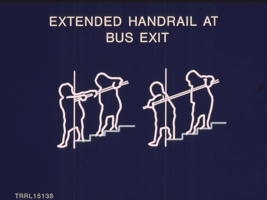
56 Since the mid-1980s, urban buses in Europe have had lower steps, better handrails and stanchions, good colour contrasts. This has made them easier for older people to use than the standard North American urban bus.

57

58

59 BUS WITH EASY ACCESS IN SWEDEN

60 Handrails each side of entrance, colour contrasted Retractable lower step

61 Exit handrails extend outside bus when doors are open Retractable lower step
62


63 EXIT FROM A BUS Easy with extended handrails More difficult with inset handrail
64 Since the early 1990s, new urban buses and trams in Europe have been mainly low floor designs These are easier for everybody to use, and can be made accessible to passengers using wheelchairs and baby buggies

65 LOW FLOOR BUS - EASY FOR EVERYBODY Bus kneels to reduce step height No internal step at entrance or exit

66 Passenger in a wheelchair boards using the ramp Call button for wheelchair ramp

67 Wheelchair unrestrained against backrest in safe compartment Stanchion prevents sideways movement of wheelchair

68 A baby buggy does not need the ramp

69 LOW FLOOR TRAM IN SERVICE - DRESDEN Where the stop has been raised to near the height of the bus or tram floor, passengers flow out as if the vehicle and stop are continuous.

70 LOW FLOOR BUSES IN SERVICE - MUNICH On low floor buses in service, there are usually not many wheelchairs, but there are a lot of babies!
71 Buses can get close to the kerb at bus stops if the kerb is extended into the road about 1.8 to 2.0 metres This type of stop can have the sidewalk raised to be level with the entrance to a low floor bus
72 PROJECTING BUS STOP BOARDER OR CAPE Sidewalk built-out about 2 metres at bus stop Sidewalk extended into road m Bus at stop Parking Sidewalk Shelter 9 to 13m Parking Guard post with reflective markings

73 A SIMPLE BUS BOARDER - READING, ENGLAND
74 BUS STOP DESIGN FROM EU COST 322 Shelter Roadway for bus Platform raised at bus stop

75 LEVEL BOARDING AT A RAISED BUS STOP
76 Community buses or Service Routes reduce walking distances to bus stops, allow more time for boarding, provide easy access and use specially trained staff

77 COMMUNITY BUS / SERVICE ROUTES

78 LOW FLOOR MIDI-BUS USED ON SERVICE ROUTES IN SWEDEN & CANADA
79 ACCESSIBLE TAXIS
80 CONCLUSION European experience shows that a combination of good pedestrian infrastructure, transit that is easy for everybody to use, Service Routes and taxis enable older people to remain mobile and independent, at least in urban areas


81 OUT AND ABOUT IN A LIVEABLE COMMUNITY
BEST PRACTICES FOR ACCESSIBLE TRANSPORT. C G B (Kit) Mitchell
 Mitchell") BEST PRACTICES FOR ACCESSIBLE TRANSPORT by C G B (Kit) Mitchell Independent mobility is necessary for independent living Many people with disabilities use cars, either as driver or passenger Those who
BEST PRACTICES FOR ACCESSIBLE TRANSPORT by C G B (Kit) Mitchell Independent mobility is necessary for independent living Many people with disabilities use cars, either as driver or passenger Those who
Copenhagen Cycling Map. Red Lines Cycling facilities
 Copenhagen Cycling Map Red Lines Cycling facilities Copenhagen Cycling Facilities Design Approaches Transportation without Pollution Copenhagen s Strategy Where Cycling is one of the top key activities
Active Transportation Facility Glossary
 Active Transportation Facility Glossary This document defines different active transportation facilities and suggests appropriate corridor types. Click on a facility type to jump to its definition. Bike
Economic and Social Council
 UNITED NATIONS E Economic and Social Council Distr. GENERAL 20 December 2006 ENGLISH Original: ENGLISH and FRENCH ECONOMIC COMMISSION FOR EUROPE INLAND TRANSPORT COMMITTEE Working Party on Road Traffic
Watertown Complete Streets Prioritization Plan. Public Meeting #1 December 14, 2017
 Watertown Complete Streets Prioritization Plan Public Meeting #1 December 14, 2017 Goals for Public Meeting Overview of MassDOT Complete Streets Funding Program Educate the community on Complete Streets
IMPLEMENTATION. PEDESTRIAN USERS (Continued /) Building Frontages: A: Stair Applications. Geometry (Accessed from the Sidewalk) Refer to A:
 Building Frontages: A: Stair Applications. Geometry (Accessed from the Sidewalk) Refer to A:") A: Stair Applications Building Frontages: Geometry (Accessed from the Sidewalk) Refer to A: Ramps should be provided for disabled users at 1:12 (8.3%) gradient. Ramp rises should be stepped at 400mm intervals.
A: Stair Applications Building Frontages: Geometry (Accessed from the Sidewalk) Refer to A: Ramps should be provided for disabled users at 1:12 (8.3%) gradient. Ramp rises should be stepped at 400mm intervals.
IMPLEMENTATION. PEDESTRIAN USERS (Continued /) A: Class 2 Pedestrian / Cycle Ways. Pedestrian and Cycle Ways:
 A: Class 2 Pedestrian / Cycle Ways. Pedestrian and Cycle Ways:") A: Class 2 Pedestrian / Cycle Ways PLAN VIEW Pedestrian and Cycle Ways: Layout and Geometry (Refer to A): Walkways and cycle to be provided adjacent to all Class 2 Roads (these facilities should always
A: Class 2 Pedestrian / Cycle Ways PLAN VIEW Pedestrian and Cycle Ways: Layout and Geometry (Refer to A): Walkways and cycle to be provided adjacent to all Class 2 Roads (these facilities should always
4. Guided Bus Explained
 4. Guided Bus Explained Contents 1 INTRODUCTION... 2 Structure of this report... 2 2 KERB GUIDED BUS... 3 Overview... 3 Kerb guidance... 3 Figures Figure 2.1 Figure 2.2 Figure 2.3 Figure 2.4 Figure 2.5
CURRENT ORIGINAL REFERENCE SECTIONS. (Typical Section) (Typical Section) The Parade Island Bay : Concept Option Summary Sheets.
 (Typical Section) The Parade Island Bay : Concept Option Summary Sheets.") ORIGINAL (Typical Section) CURRENT (Typical Section) 3,900 3,000 2,000 1,500 3,100 1,600 3,100 1,500 2,000 2,500 3,900 3,000 1,800 600 2,000 3,000 3,000 2,000 600 1,800 2,500 Existing Planting Traffic
ORIGINAL (Typical Section) CURRENT (Typical Section) 3,900 3,000 2,000 1,500 3,100 1,600 3,100 1,500 2,000 2,500 3,900 3,000 1,800 600 2,000 3,000 3,000 2,000 600 1,800 2,500 Existing Planting Traffic
Road Traffic Signs in Germany
 Warning signs Road Traffic Signs in Germany General danger Curve left Curve right Double curve Double curve Accident hazard Sliding danger Winter sports along road Soft shoulder Rough road edge Steep upgrade
COWETA HIGH SCHOOL AND EAST HIGHWAY 51
 COWETA HIGH SCHOOL AND EAST HIGHWAY 51 Lack of sidewalks along Ben Lumpkin Rd. Lack of crosswalks and ramps at intersection. Hwy 51 is wide to cross as a pedestrian. No ADA compliance or connection to
Off-road Trails. Guidance
 Off-road Trails Off-road trails are shared use paths located on an independent alignment that provide two-way travel for people walking, bicycling, and other non-motorized users. Trails specifically along
TRAFFIC CALMING GUIDE FOR TORONTO CITY OF TORONTO TRANSPORTATION SERVICES DIVISION
 TRAFFIC CALMING GUIDE FOR TORONTO CITY OF TORONTO TRANSPORTATION SERVICES DIVISION CITY OF TORONTO TRANSPORTATION SERVICES DIVISION 2016 TRAFFIC CALMING GUIDE FOR TORONTO TABLE OF CONTENTS Introduction
Creating walkable, bikeable and transit-supportive communities in Halton
 Creating walkable, bikeable and transit-supportive communities in Halton By presenting current research and best practices, the information in this paper is meant to support and broaden discussion on how
What Is a Complete Street?
 Session 5 Charleen Zimmer, AICP, Zan Associates May 5-7, 2010 What Is a Complete Street? May 2010 5-1 Not a Complete Street More of a Complete Street May 2010 5-2 Benefits of Complete Streets Safety for
Appendix C. TRAFFIC CALMING PROGRAM TOOLBOX
 Appendix C. TRAFFIC CALMING PROGRAM TOOLBOX PHASE I...2 Do Not Enter Sign...3 One-Way Sign...4 Turn Prohibition...5 Pavement Markings...6 Speed Monitoring Trailer...7 Neighborhood Speed Watch...8 Police
ThinkBike Workshop. Los Angeles September 22-23, 2011
 September 22-23, 2011 The Experts Cor van der Klaauw Groningen Province Richard ter Avest Goudappel Coffeng Consultancy The Experts Tonny Bosch Goudappel Coffeng Consultancy Hillie Talens CROW Cycling
Perne Rd / Radegund Rd Roundabout Cambridge
 Perne Rd / Radegund Rd Roundabout Cambridge The conversion of an conventional urban roundabout to continental geometry A little bit of history The first traffic roundabout was built in Sollershott, Letchworth
complete streets design and construction standards public primer City of Edmonton
 complete streets design and construction standards public primer City of Edmonton introduction Complete Streets are streets for everyone: people who walk, wheel, bike, take transit, or drive. They are
PRINCE GEORGE S PLAZA METRO AREA PEDESTRIAN PLAN
 PRINCE GEORGE S PLAZA METRO AREA PEDESTRIAN PLAN May 28, 2008 Agenda Welcome and introductions Project overview and issue identification Planning context and strengths Design challenges and initial recommendations
City of Elizabeth City Neighborhood Traffic Calming Policy and Guidelines
 City of Elizabeth City Neighborhood Traffic Calming Policy and Guidelines I. Purpose: The City of Elizabeth City is committed to ensure the overall safety and livability of residential neighborhoods. One
Mobility measures in Vitoria-Gasteiz
 CIVITAS Study Tour in Vitoria-Gasteiz, Spain 19 & 20 June 2014 Palacio Zulueta Public Space and Nature Environment Service, Paseo de la Senda 2, Vitoria-Gastez Giving back the public space to the people
Frome Street Bicycle Route
 The Adelaide City Council invites engagement from the community about Frome Street Bicycle Route Project Summary Adelaide City Council is seeking feedback on design options to construct bicycle facilities
Prince George s County plans, policies, and projects
 Prince George s County plans, policies, and projects Over 250 projects for trails, bikeways, designated bike lanes and sidewalk construction Trail projects that improve access to Metro Sidewalk and trail
Peterborough Council on Aging
 Peterborough Council on Aging Discussion paper series #4, 2015 Transportation Transportation, including accessible and affordable public transport is a key factor influencing active aging. in particular,
BETHEL ROAD AND SEDGWICK ROAD CORRIDOR STUDY
 DRAFT PLAN City Council Meeting August 14, 2017 STUDY AREA Sedgwick Corridor State Route 160, principal arterial with Class 3 access management designation, commuter and freight route, connection to SR
A Guide to Great Streets: The Basics. September 25, 2009
 A Guide to Great Streets: The Basics September 25, 2009 Streets are more than connectors, they are the city 2 Streets are the glue that hold a city together 3 Streets are the means in which a city is perceived
C/CAG. Sunnybrae Elementary School Walking and Bicycling Audit. San Mateo-Foster City School District JUNE 2013
 Sunnybrae Elementary School Walking and Bicycling Audit JUNE 2013 San Mateo-Foster City School District C/CAG City/County Association of Governments of San Mateo County SUNNYBRAE ELEMENTARY SCHOOL WALKING
City of Wayzata Comprehensive Plan 2030 Transportation Chapter: Appendix A
 A1. Functional Classification Table A-1 illustrates the Metropolitan Council s detailed criteria established for the functional classification of roadways within the Twin Cities Metropolitan Area. Table
Bicycle Facilities Planning
 Bicycle Facilities Planning Overview Types of Cyclists Purpose for Riding Types of Facilities Bike Lanes Bicycle Boulevards Cycle Tracks Intersections Signals Signing and Marking Discussion Types of Bicyclists
Classification Criteria
 SCHEDULE D TO RECOMMENDED OFFICIAL PLAN AMENDMENT NO. 40 SCHEDULE C-4 Road Criteria Criteria Traffic Service Objective Land Service/Access Typical Daily Traffic Volume Flow characteristics Travel Speed
Downtown BRT Corridor Alternatives Review: 1 st, 2 nd, 3 rd and 4 th Avenue. Bus Rapid and Conventional Transit Planning and Design Services
 Downtown BRT Corridor Alternatives Review: 1 st, 2 nd, 3 rd and 4 th Avenue Bus Rapid and Conventional Transit Planning and Design Services City of Saskatoon February 2018 Project Team HDR Corporation
9/25/2018. Multi-Modal Level of Service (MMLOS) Bianca Popescu, Transportation Planner
 Bianca Popescu, Transportation Planner") Multi-Modal Level of Service (MMLOS) Bianca Popescu, Transportation Planner 1 What is MMLOS? Is this a nice place to walk? Is this a nice place to bike? Is transit convenient? Bottom line - Are there options
Multi-Modal Level of Service (MMLOS) Bianca Popescu, Transportation Planner 1 What is MMLOS? Is this a nice place to walk? Is this a nice place to bike? Is transit convenient? Bottom line - Are there options
Traditional Public Transport Priority. Priority/Traffic Management? What is Integrated Public Transport Priority/Traffic management? Why? How?
 Integrated Public Transport Priority & Traffic Management Sam Zimmerman What is Integrated Public Transport Priority/Traffic management? Why? How? Integrated Public Transport Priority/Traffic Management?
Frascati Road and Temple Hill Route Improvements. Outline Design Report to Accompany Public consultation
 Frascati Road and Temple Hill Route Improvements Outline Design Report to Accompany Public consultation September 2013 Background: Dún Laoghaire-Rathdown is committed to providing high quality pedestrian
ST BEDE S CATHOLIC COLLEGE TRAFFIC MANAGEMENT PLAN
 ST BEDE S CATHOLIC COLLEGE TRAFFIC MANAGEMENT PLAN APPLICABLE TO Staff, students and parents DOCUMENT OWNER Principal APPROVAL DATE 6 th July 2018 APPROVED BY Principal SCHOOL ACTIONS School Policy Staff
Why Zone In on Speed Reduction?
 Learn it. Do it. Live it! SPEED REDUCTION IN THE ZONE Why Zone In on Speed Reduction? Speeding is a serious issue that plays a major role in the risk of serious injury and pedestrian fatality in a crash.
Department of Transportation
 Department of Transportation I. Internal Scan The number of older drivers in the United States will double over the next 30 years. By 2030 one in five Americans will be age 65 or older. On a licensed-driver
Side Roads and Other Non-Signalised Junctions
 Green Surfacing Sections of the Cycle Superhighway are marked with green paint these highlight sections where people cycling the Superhighway are likely to come into contact with walkers, drivers, or other
El Camino Real Specific Plan. TAC/CAC Meeting #2 Aug 1, 2018
 El Camino Real Specific Plan TAC/CAC Meeting #2 Aug 1, 2018 Land Use Alternatives Goals and Tradeoffs Parks & open space Housing Retail & services Civic spaces Parking Community gathering spaces 3 Alternatives
Guidance. ATTACHMENT F: Draft Additional Pages for Bicycle Facility Design Toolkit Separated Bike Lanes: Two-Way to One-Way Transitions
 ATTACHMENT F: Draft Additional Pages for Bicycle Facility Design Toolkit Separated Bike Lanes: Two-Way to One-Way Transitions This treatment provides a transition from two-way separated bike lanes to one-way
Entry Treatments. Traffic Advisory Leaflet 2/94 August Introduction. Design. Vertical Deflections. Locations
 Traffic Advisory Leaflet 2/94 August 1994 Entry Treatments Introduction Entry treatments have been developed for use at side roads so that drivers leaving a major road are in no doubt that they are entering
Footpath design. A guide to creating footpaths that are safe, comfortable, and easy to use
 Footpath design A guide to creating footpaths that are safe, comfortable, and easy to use November 2013 Contents Introduction / 1 Zoning system / 2 Width / 4 Height / 5 Surface / 5 Footpath elements /
Multimodal Transportation Plan
 Multimodal Transportation Plan The Multimodal Transportation Plan will accommodate MILLENIALS ARE DRIVING LESS. WE CANNOT BUILD OUR WAY all modes of transportation by keeping pedestrians, OUT OF CONGESTION.
Background. Caversham a vision for the future. Joint public meeting arranged by:
 Joint public meeting arranged by: Sharing our Streets Caversham a vision for the future and Caversham Traders Association This presentation followed a presentation by Simon Beasley, Network Manager for
Roadways. Roadways III.
 Introduction 97 Roadway Design Principles 98 Safe Speeds 99 Optimizing of Street Space 00 Minimum Lane Widths in the City of Boston 02 Design Features that Reduce Operating Speeds 05 Travel Lanes Transit
European Student Competition VOICE Vulnerable Road Users Organizations in Cooperation Across Europe
 European Student Competition VOICE Vulnerable Road Users Organizations in Cooperation Across Europe Name of task: Modernization of Grochowska street in Warsaw Area of Grochowska and Minska crossroad Full
Active Travel Survey for Bridgend and Pencoed towns. Page description:
 Active Travel Survey for Bridgend and Pencoed towns Page description: Bridgend County Borough Council want to hear from you on how you think we can improve facilities for walking and cycling in and around
International cooperation to improve the safety of European pedestrian crossings
 International cooperation to improve the safety of European pedestrian crossings Francesco Mazzone Head of International Assessment Programmes ACI Automobile Club d Italia Polis Conference Barcelona, 25
5. MODIFICATIONS AT JEANNE D ARC BOULEVARD/REGIONAL ROAD 174 INTERCHANGE INTERSECTION - PUBLIC HEARING COMMITTEE RECOMMENDATION
 5. MODIFICATIONS AT JEANNE D ARC BOULEVARD/REGIONAL ROAD 174 INTERCHANGE INTERSECTION - PUBLIC HEARING COMMITTEE RECOMMENDATION Having held a public hearing, that Council approve the preliminary designs
Walking Audit Supporting Information
 Walking Audit Supporting Information Planning to do a walking audit of your streets? Here s some helpful suggestions to help get you started. 1. Preparing for your audit Decide where you want to walk.
Bicyclists and Truck Driver Visibility
 Bicyclists and Truck Driver Visibility Posting Date: 08-Aug 2014 On August 7th, 2014 a 19-year-old female cyclist was killed when her bicycle was run over by a concrete mixer truck at the intersection
components 6.1 Introduction 6.2 Traffic-reduction engineering techniques
 6 Pedestrian network components Choosing the best options Reduce and calm traffic Better paths, ramps, steps, driveways, kerb crossings Select the best crossing facility Select the best crossing provision
EUROPEAN MOBILITY WEEK September 2015
 EUROPEAN MOBILITY WEEK 16-22 September 2015 Description and objective The European Mobility Week is an annual campaign on sustainable urban mobility, organised with the support of the Directorates General
COMPLETE STREETS PLANNER S PORTFOLIO
 COMPLETE STREETS PLANNER S PORTFOLIO ISSUE 3 APRIL 2016 PLANNER S PORTFOLIO COMPLETE STREETS 1 2 6 10 14 OVERVIEW MATURE NEIGHBORHOODS GROWING SUBURBS CENTRAL PLACES ACTIVITY CORRIDORS Planner s Portfolio
PERFORMANCE ACTIVITY 613 IMPACT ATTENUATOR WORK DESCRIPTION 3
 PERFORMANCE ACTIVITY 613 IMPACT ATTENUATOR WORK DESCRIPTION 1 WORK DESCRIPTION 2 WORK DESCRIPTION 3 Install Remove Repair 613 IMPACT ATTENUATOR ACTIVITY DESCRIPTION Repair, install, remove and maintain
RIVERSIDE, Newton MA BH NORMANDY RIVERSIDE LLC. Riverside Station. A green, transit-oriented community
 Riverside Station A green, transit-oriented community October 6, 2011 TONIGHT S AGENDA: 1. Project Update (5 min.) 2. Master Plan Update (10 min.) 3.Traffic Plan Update (10 min.) Questions & Answers MASTER
CHAPTER 5: GENERAL SITE AND BUILDING ELEMENTS
 CHAPTER 5: GENERAL SITE AND BUILDING ELEMENTS 501 General 501.1 Scope. The provisions of Chapter 5 shall apply where required by Chapter 2 or where referenced by a requirement in this document. 502 Parking
Road Safety. Inspections
 Title of your presentation Road Safety Name and contact details Inspections Phil Allan Australiaame ROAD SAFETY SEMINAR Lome, Togo October 2006 Definition A Road Safety Inspection (RSI) is an on-site systematic
Strategy for Walking & Cycling Action Plan
 Strategy for Walking & Cycling Action Plan To achieve higher levels of walking and cycling activity, the destinations which people access have to be available within suitable distances and designed to
Agenda. Overview PRINCE GEORGE S PLAZA METRO AREA PEDESTRIAN PLAN
 PRINCE GEORGE S PLAZA METRO AREA PEDESTRIAN PLAN May 28, 2008 Agenda Welcome and introductions Project overview and issue identification Planning context and strengths Design challenges and initial recommendations
Road safety design standards and the Asian Highway Network. irap Asia Pacific Workshop Greg Smith 2016/05/26
 Road safety design standards and the Asian Highway Network irap Asia Pacific Workshop Greg Smith (greg.smith@irap.org) 2016/05/26 AH Standard Summary While developing the Asian Highway network, Parties
Appendix A Type of Traffic Calming Measures Engineering Solutions
 Appendix A Type of Traffic Calming Measures Engineering Solutions PHYSICAL MEASURES Central Hatching The major consideration of this feature is that, these markings can only be laid down the centre of
Broad Street Bicycle Boulevard Design Guidelines
 Broad Street Bicycle Boulevard Design Guidelines Building from the strategies introduced in the 2013 Bicycle Transportation Plan and community input received thus far, City Transportation Staff have identified
CURBSIDE ACTIVITY DESIGN
 5 CURBSIDE ACTIVITY DESIGN This chapter provides design guidance for separated bike lanes adjacent to curbside activities including parking, loading and bus stops. Typical configurations are presented
Bicycle + Pedestrian Connectivity Gap Analysis
 Accelerated Bridge Program Bicycle + Pedestrian Connectivity Gap Analysis Tuesday, October 11 Shriners Hospital, Boston 6:30-8:00 PM Thursday, October 13 Community Rowing, Brighton 6:30-8:00 PM Tuesday,
AUTOMATED AND ZERO EMISSION VEHICLES HOW THEY MIGHT RESHAPE OUR STREETS
 AUTOMATED AND ZERO EMISSION VEHICLES HOW THEY MIGHT RESHAPE OUR STREETS BACKGROUND: This study is a collaboration between Urban Circus (Visualisation) and Ethos Urban (Urban Design) Ideas were workshopped
Chapter 5. Complete Streets and Walkable Communities.
 Chapter 5. Complete Streets and Walkable Communities. 5.1 Description of Complete Streets. Cities throughout the world, and specifically the United States, are coming to embrace a new transportation and
ECONOMY PEOPLE ENVIRONMENT
 Report Back on Local Transit Improvements May 29, 2013 ECONOMY PEOPLE ENVIRONMENT Intro Council Requested Report Back Topics Progress on Planning for Broadway Subway False Creek Bridges Local Transit Improvements
Signs. signs, signals and road markings. in this chapter
 3 signs, signals and road markings in this chapter Signs regulatory signs school, playground and crosswalk signs lane use signs turn control signs parking signs reserved lane signs warning signs object
TGSI Tactile Ground Surface Indicators
 TGSI Tactile Ground Surface Indicators Introduction: This Design Note, No 11, provides guidelines and requirements for the use and installation of Tactile Ground Surface Indicators (TGSI s). References
Marcus Jones, TRL. Presented by Name Here Job Title - Date
 Segregation Insert the title and of priority your at presentation junctions: a here discussion Marcus Jones, TRL Presented by Name Here Job Title - Date Background: TfL cycle facility trials Infrastructure
CITY OF OTTAWA ROADWAY MODIFICATION APPROVAL UNDER DELEGATED AUTHORITY
 RMA-2015-ATM-038 CITY OF OTTAWA ROADWAY MODIFICATION APPROVAL UNDER DELEGATED AUTHORITY DATE: April 22, 2015 SUBJECT Approval of Roadway Modifications Recommended through an Area Traffic Management Study
SAFETY GUIDE FOR SCHOOL CHILDREN & PARENTS. toronto.ca/visionzeroto #VisionZeroTO
 SAFETY GUIDE FOR SCHOOL CHILDREN & PARENTS toronto.ca/visionzeroto #VisionZeroTO VISION ZERO ROAD SAFETY PLAN Toronto s Vision Zero Road Safety Plan is a five-year strategy for eliminating traffic-related
Report. Typical Sections. City of Middleton, WI
 Report Typical Sections City of Middleton, WI December 2006 Report for City of Middleton, Wisconsin Typical Sections repared by: Traffic Associates LLC and STRAND ASSOCIATES, INC. 910 West Wingra Drive
Builta Arrival and Dismissal Procedures
 Builta Arrival and Dismissal Procedures The safety of your children/our students is our first concern. The system now in place establishes a pattern for children to arrive and depart safely from Builta.
BUILDING CHINARAP. Zhang Tiejun Research Institute of Highway (RIOH) Beijing, China
 Beijing, China") BUILDING CHINARAP Zhang Tiejun Research Institute of Highway (RIOH) Beijing, China E-mail: tj.zhang@rioh.cn Greg Smith International Road Assessment Programme (irap) Beijing, China E-mail: greg.smith@irap.org
BUILDING CHINARAP Zhang Tiejun Research Institute of Highway (RIOH) Beijing, China E-mail: tj.zhang@rioh.cn Greg Smith International Road Assessment Programme (irap) Beijing, China E-mail: greg.smith@irap.org
Route 29 Solutions Projects
 Route 29 Solutions Route 29 Solutions Projects www.route29solutions.org October 10, 2014 Route 29 Widening to Six Lanes Albemarle County This project will widen a 1.8-mile segment of Route 29 from four
4 GENERIC COST ESTIMATING TOOL
 4 GENERIC COST ESTIMATING TOOL Table 4-1 presents a generic cost estimating tools that can serve as a conceptual planning tool for local jurisdictions to estimate the costs of pedestrian improvements.
Bus Lane Laws. What happens if you have to go into a bus lane? Bus lanes. Penalties of using bus lanes. When can you use them? Who can use them?
 CITY DRIVING GUIDE Introduction There are major differences for drivers driving in cities as opposed to driving on roads elsewhere. The set of challenges the driver will face driving in a city can be daunting
Ohio Share the Road Driver s s Education Unit
 Ohio Share the Road Driver s s Education Unit Bicyclists are Drivers of Vehicles 4501.01. Definitions (A) "Vehicle" means every device, including a motorized bicycle, in, upon, or by which any person or
PERFORMANCE ACTIVITY 405 LIMB MANAGEMENT
 PERFORMANCE ACTIVITY 405 LIMB MANAGEMENT 405 LIMB MANAGEMENT ACTIVITY DESCRIPTION Cut and/or remove and/or grind tree limbs from the right-of-way. TRAFFIC CONTROL Utilize intermittent mobile operations
CHECKLIST 5: ROADWORK TRAFFIC SCHEME AUDIT
 CHECKLIST 5: ROADWORK TRAFFIC SCHEME AUDIT 5.1 General items 5.1.1 Alignment Are the roadworks located safely with respect to horizontal and vertical alignment? If not, does works signing cater for this?
CITY OF SASKATOON COUNCIL POLICY
 ORIGIN/AUTHORITY Clause 1, Report No. 1-1980 and Clause 4, Report No. 22-1990 of the Works and Utilities Committee; Clause 6, Report No. 17-2004 of the Planning and Operations Committee; and Clause D5,
Mission-Geneva Transportation Study Community Workshop 2 July 8, 2006
 Community Workshop 2 July 8, 2006 Small Group Workbook 1 Basic Improvements on Mission Street Streetscape. Pedestrian-scale lighting; landscaping; community art on utility boxes; more (possibly unique)
Complete Streets 101: The Basics
 Complete Streets 101: The Basics Michigan Municipal League - Capital Conference March 21, 2017 Chip Smith, AICP - Senior Planner - Wade Trim Inc. and City Council member City of Ann Arbor 2017 MML Capital
Active Transportation Infrastructure Investment A Business Case
 Active Transportation Infrastructure Investment A Business Case In 2016, the Real Estate Foundation awarded the Capital Regional District a $50,000 grant for Shifting Gears: Land Use Change through Active
10 SHERFORD Town Code
 Key Fixes (Ref: Masterplan Book, section 4a. Land Use Budget and Key Fixes ) The Town Plan designs and allocates buildings, streets and spaces as accurately as possible in the understandable absence of
Regulatory traffic signs
 Section 21: Regulatory traffic signs This section includes the signs that show a road regulation is in place. These must be obeyed. Regulatory signs show the course a driver must follow and an action they
Multimodal Through Corridors and Placemaking Corridors
 68 Multimodal Through Corridors and Placemaking Corridors Corridors have different functions in a region. Some corridors are used to get smoothly and rapidly through a region or to get quickly to major
to the Public Information Centre for the Downtown Traffic Study
 to the Public Information Centre for the Downtown Traffic Study City of Sault Ste. Marie July 25, 2018 Purpose of Study Determine if changes to one-way corridors can enhance downtown s character and spaces
Walk On, Victoria Pedestrian Issues Policy Research
 Issue: Distracted walking a. Study of police accident report data shows no correlation between distracted walking and an increase in injury or death, similar data for distracted driving shows a steep relationship.
West Village Mobility & Integration
 West Village Mobility & Integration PRESENTED TO TOPCA Town Hall November 9, 2017 [7189-21] Port Credit 2 West Village + Mobility AWalkable Community A CompleteCommunity A SustainableCommunity 3 Mobility
Chapter 4 - Links Within the Highway. Suitability of Routes
 Chapter 4 - Links Within the Highway Suitability of Routes Most cycling takes place on existing urban roads; this will also be the case with the National Cycle Network. As well as following lightly trafficked
Lawrence Avenue Streetscape Concepts August 30, 2011
 Lawrence Avenue Streetscape Concepts August 30, 2011 Neighborhood Context Phase II: River to Western Ave. Phase I: Western Ave. to Clark St. Key Map Lawrence Ave. Existing Streetscape Conditions East of
PERFORMANCE ACTIVITY 306 DRAINAGE PIPE WORK DESCRIPTION 4
 PERFORMANCE ACTIVITY 306 DRAINAGE PIPE WORK DESCRIPTION 1 WORK DESCRIPTION 2 WORK DESCRIPTION 3 WORK DESCRIPTION 4 Repair Install Remove Clean 306 DRAINAGE PIPE ACTIVITY DESCRIPTION Install, repair, clean,
Bridgewater Complete Streets Prioritization Plan and Pedestrian Safety Assessment
 Bridgewater Complete Streets Prioritization Plan and Pedestrian Safety Assessment Presented by Luciano Rabito Manager of Complete Streets Presented to Bridgewater, MA Wednesday, April 26, 2017 6:30 P.M.
Traffic calming regulations (Scotland)
") Traffic Advisory Leaflet 11/94 December 1994 Traffic calming regulations (Scotland) Introduction Traffic calming can help drivers to make their speeds appropriate to local conditions, through measures
Traffic Advisory Leaflet 11/94 December 1994 Traffic calming regulations (Scotland) Introduction Traffic calming can help drivers to make their speeds appropriate to local conditions, through measures
Controlled. Semi-Controlled PAGE 01 CHAPTER 12 INTERSECTIONS
 PAGE 01 CHAPTER 12 INTERSECTIONS You will cross many intersections while driving. Intersections are especially dangerous because vehicles are crossing each other s driving path. Many crashes happen at
Simulation Analysis of Intersection Treatments for Cycle Tracks
 Abstract Simulation Analysis of Intersection Treatments for Cycle Tracks The increased use of cycle tracks also known as protected bike lanes has led to investigations of how to accommodate them at intersections.