SR/CR A1A PEDESTRIAN SAFETY & MOBILITY STUDY
|
|
|
- Aileen Boyd
- 6 years ago
- Views:
Transcription


1 SR/CR A1A PEDESTRIAN SAFETY & MOBILITY STUDY PEDESTRIAN / BICYCLE SAFETY REVIEW Focus Area B / Park Avenue to Ribault Avenue (Daytona Beach Shores/Daytona Beach Prepared for: River to Sea Transportation Planning Organization 2570 West International Speedway Boulevard, Suite 100 Daytona Beach, FL Prepared by: Kittelson & Associates, Inc. 225 E. Robinson Street, Suite 450 Orlando, FL kittelson.com October 2016

2 SR/CR A1A Pedestrian Safety & Mobility Study Pedestrian/Bicycle Safety Review Report for Focus Area B: SR A1A from Park Avenue to Ribault Avenue (Daytona Beach Shores/Daytona Beach) Section Number: Mile Post: Volusia County Prepared for: River to Sea Transportation Planning Organization 2570 West International Speedway Boulevard, Suite 100 Daytona Beach, FL Prepared by: Kittelson & Associates, Inc. 225 E Robinson St., Suite 450 Orlando, FL, October 2016
3 Project Title: Focus Area B Pedestrian/Bicycle Safety Field Review Field Review Dates: January 28 th and 29 th, 2016 (daytime/nighttime reviews and follow up meeting) Participants: Ryan Cunningham Kittelson & Associates, Inc. Team Leader Stephan Harris River to Sea Transportation Planning Organization Chad Lingenfelter Florida Department of Transportation, District 5 Jon Cheney Volusia County (January 28 th only) Mike Marcum City of Daytona Beach Rich Walton City of Daytona Beach (January 29 th only) Amy Boyd City of Daytona Beach Sergeant Mike Uleski Daytona Beach Shores PD Officer Jason Kilker Daytona Beach PD John Cotton - VoTran Travis Hills Kittelson & Associates, Inc. Project Characteristics: Field Review Type: Pedestrian, Bicycle, Existing Road Adjacent Land Use: Urban, Commercial, Hotels, Residential Posted Speed Limit: 35 miles per hour (mph) along the length of the study corridor Opposite Flow Separation: Center Two-Way Left-Turn Lane (TWLTL) Service Function: Urban Principal Arterial Terrain: Flat Climatic Conditions: Cloudy, Raining, Cold 1
.")
4 END PROJECT BEGIN PROJECT Source: Google Maps 2015 Figure 1 Focus Area B Study Corridor Background Volusia County is ranked in Florida s top 10 counties for pedestrian injuries and fatalities. Pedestrians and bicyclists are identified as Vulnerable Road Users in the Florida Strategic Highway Safety Plan (SHSP). The goal of the SR/CR A1A Pedestrian Safety & Mobility Study is to generate a list of suggested improvements at high pedestrian/bicycle crash locations to address the growing need for pedestrian/bicycle safety along SR A1A in Volusia and Flagler Counties. SR A1A from Park Avenue to Ribault Avenue (Figure 1), a 1.00 mile corridor in Daytona Beach Shores/Daytona Beach, was identified as one of these high crash locations. In order to suggest improvements along this high crash corridor, the crash history was evaluated and a field review was conducted. The methodology for selecting high crash corridors is explained in the SR A1A Pedestrian Safety and Mobility Study Final Report. This report will be available on the River to Sea TPO s website upon the completion of the study: The pedestrian/bicycle safety review process involves multi-disciplinary representatives from various stakeholders, potentially including representatives from transportation planning, traffic operations, 2
5 roadway design, safety, and law enforcement. Pedestrian/bicycle safety reviews are conducted to identify potential safety issues and provide improvement suggestions in a team collaborative environment. This pedestrian/bicycle safety review was commissioned by the River to Sea Transportation Planning Organization (R2CTPO) to develop short-term, near-term, and long-term suggestions to improve pedestrian and bicyclist safety within the study limits. This safety review is limited in scope and should not be construed as a comprehensive safety study; nor is it a formal Road Safety Audit. It is intended to identify potential operational and safety related improvements related to pedestrians and bicyclists to be considered by R2CTPO staff and partner agencies (i.e. FDOT District Five (D5), Volusia County, Daytona Beach Shores, Daytona Beach, VoTran, local law enforcement). Some improvements presented in this report may be implemented in the short-term while other suggested safety improvements may be considered for future study. Each suggestion identified in this study is classified into one of three categories: Short-Term Maintenance it is anticipated that issues identified for maintenance may be addressed by public agency staff on a short timeframe and at a relatively low cost. Near-Term Improvement activities that may be incorporated into an upcoming construction project in the area, including 3R milling and resurfacing projects. Long-Term Improvement activities that may be incorporated into upcoming construction projects and may need to be programmed for funding as separate projects. The field review was conducted on Thursday January 28 th, The team met in the morning at the Volusia County Lifeguard Headquarters to discuss the study corridor and crash history. After lunch, the study team drove the entire corridor, south to north then north to south, to gain an understanding of the facility characteristics from a driver s perspective. The team then walked the length of sidewalk along the north and south sides of the roadway. The team reassembled in the evening, after sunset, to make observations in nighttime conditions. A follow-up debrief meeting was held at Volusia County Lifeguard Headquarters the following morning (January 29 th ) to discuss the corridor s issues and potential improvements identified by the team. Study corridor characteristics are reviewed below: Park Avenue to Ribault Avenue 1.00 miles. Typical cross section Five-lane roadway with a center two-way left-turn lane (TWLTL). The posted speed along the study corridor limits is 35 MPH. Two (2) signalized intersections at Botefuhr Avenue and SR 441/Silver Beach Avenue: o Botefuhr Avenue Old special emphasis crosswalk markings along the north and south legs. Standard crosswalk markings on the east and west legs. o SR 441/Silver Beach Avenue Old special emphasis crosswalk markings along the four legs. The distance between signalized intersections is approximately 0.7 miles. There are no other marked crossings along the study corridor. Continuous sidewalks along both sides of the roadway for the length of the study corridor; No bicycle lanes or paved shoulders are provided along the length of the study corridor; Type F curb and gutter along the length of the study corridor; Votran, Volusia County s public transit system, serves SR A1A within the study limits; Overhead street lighting is present along both sides of the study corridor; and The study corridor has experienced an average AADT of 11,200 vehicles/day over the last six years ( ). 3
6 Crash History ( ) Six (6) years of available pedestrian and bicycle related crash data, 2009 to 2014, were utilized for the SR A1A crash analysis. Crash data was obtained from two sources: 1. The FDOT Crash Analysis Reporting System (CARS) database from 2009 to 2013 and 2. The Signal Four Analytics database, maintained by University of Florida from 2009 to The 2014 CARS data was not yet FDOT certified at the time this study was initiated, thus the reason for six years of crash data instead of the traditional five. The additional crashes from the Signal Four database supplemented the CARS data along SR A1A. Eight (8) pedestrian or bicycle-related crashes were reported over the six-year study period, seven (7) involved pedestrians and one (1) involved a bicyclist. All eight (8) pedestrian and bicycle crashes were injury crashes. No fatal pedestrian or bicycle crashes were reported during the analysis period. Crash diagrams were created along the corridor to summarize the pedestrian/bicycle-related crash history. The crash diagrams are included in Appendix A. The pedestrian/bicycle crash data was also summarized by the crash metrics displayed in the charts in Appendix A. A summary of these metrics, signalized intersection crashes, and locations with more than one crash, are provided below: Sixty-three (63) percent of the crashes occurred in dark lighting conditions; All reported crashes occurred under dry roadway conditions; Seventy-five (75) percent of the crashes occurred between 2009 and No crashes occurred in 2013 or The Average Annual Daily Traffic (AADT) along the corridor decreased slightly between 2009 and 2010 and began to increase in The corridor has experienced an average AADT of 11,200 over the six year analysis period; All eight (8) crashes occurred between Wednesday and Saturday. There were three (3) crashes on Saturday; There were two (2) crashes in October, the only month with more than one crash; Five (5) of the eight (8) crashes occurred between 9:00 PM and 1:00 AM; Four (4) of the pedestrians or bicyclists were not from the state of Florida based upon their provided zip codes; None of the reported crashes involved alcohol or drugs; The vehicle had the right-of-way in four (4) of the seven (7) pedestrian crashes, all of them occurring when a pedestrian was attempting to cross SR A1A at a mid-block location; The vehicle had the right-of-way in the one (1) bicycle crash occurring just south of Silver Beach Avenue; One (1) pedestrian crash occurred at the signalized intersection of Botefuhr Avenue when a pedestrian crossing the north leg crosswalk was struck by a westbound right turning vehicle. This crash occurred at night; and One (1) pedestrian crash occurred at the signalized intersection of SR 441/ Silver Beach Avenue when a pedestrian crossing the north leg crosswalk was struck by an eastbound left turning vehicle. 4


7 FIELD REVIEW FINDINGS Location: Corridor-Wide Issue #1: Lighting Figure 2 Figure 3 Description of Issue: Daytona Beach Shores and Daytona Beach are destinations for sea turtle nesting. Sea turtles are a protected species in Volusia County. Volusia County has developed a Beach Lighting Management Plan and issued a lighting ordinance to minimize light reaching the beach and potentially disrupting the sea turtle nesting. The sea turtle nesting season is from May 1 to October 31. Shutting street lights off or using a shield on the street light poles to minimize light emittance are two measures utilized on SR A1A during the sea turtle nesting season. While the five nighttime crashes occurred outside of turtle season, the turtle season lighting measures were still in effect along the corridor. Shutting off lights or using the turtle shields negatively impact the lighting conditions for the roadway users. Reducing the light can make it difficult for drivers to see pedestrians or bicyclists at night, especially those wearing dark clothing. Figure 2 and Figure 3 illustrate the lighting levels the safety team observed. The safety study team observed the roadway lighting conditions at night and had the following observations: Lighting levels and spacing were inconsistent along the corridor; Inconsistent turtle lighting treatments, some light poles on the west side were outfitted with turtle shielding while others were not; o Shields were still installed on west side poles even though it was not turtle season. Some of the street lights were either off or not working properly; o Between Silver Beach Avenue and Frances Terrace, the street lights on both sides of the roadway were completely shut off. 5
8 Suggestions for Improvement: The following are considerations for lighting along the corridor: Replace the lights on the corridor that are burnt out. Consider conducting field measurements of existing lighting levels to evaluate lighting uniformity levels and add lighting where necessary. Consider light poles on the east side that are angled westerly away from the beach. These light poles cast their light to the west and illuminate the roadway as needed. The light bulb is not seen by the turtles due to the angle and orientation of the light fixture. Consider implementing a lighting plan for the time the sea turtle nesting season is not active as roadway lighting levels should not be reduced at this time. Consider implementation of pedestrian-level lighting, with less visibility from the beach, to supplement areas where street lighting is not able to provide adequate lamination. As a long-term consideration, upgrade to an adaptive roadway lighting system along the corridor. Lighting levels could be programmed to be reduced during the sea turtle nesting season and increased to normal levels outside of the nesting season. This could be coupled with replacing the current high pressure sodium lighting with LED lighting. 6

 pedestrian crashes occurred outside of a marked crosswalk between Botefuhr Avenue and Ribault Avenue.")

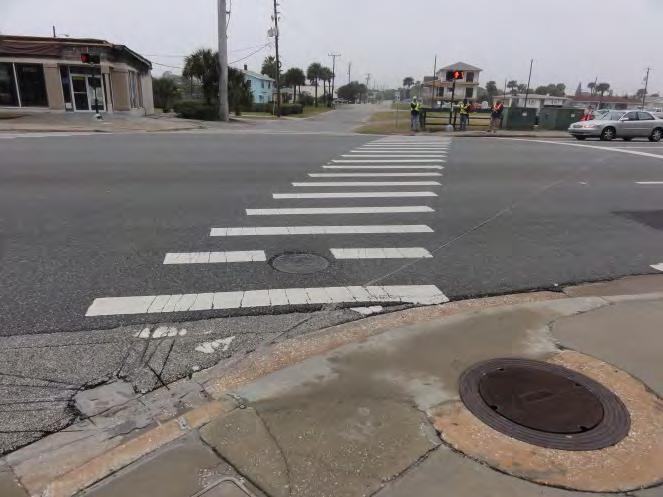
9 Location: Corridor-Wide Issue #2: Mid-Block Crossings Figure 4 Figure 5 Figure 6 Description of Issue: As noted in the background, only two signalized marked crossing locations are present along the corridor at Botefuhr Avenue and Silver Beach Avenue but these signals are spaced approximately 0.70 miles apart. Without the provision of marked crosswalks at regular intervals and the five-lane roadway cross section (Figure 4), pedestrians cross SR A1A wherever it is convenient or desirable and they tend to utilize the TWLTL for refuge. Five of the eight (63 percent) pedestrian crashes occurred outside of a marked crosswalk between Botefuhr Avenue and Ribault Avenue. Current land uses along the corridor encourage pedestrians to cross SR A1A at unmarked locations. Some hotels on the east side of the roadway have their parking on the west side of the roadway. Bus stops are also placed at mid-block locations and pedestrian/bicycle beach access points are located throughout the corridor. The study team counted approximately 20 parcels along the corridor that were vacant with no buildings or had buildings that were unoccupied by a tenant (Figure 5). When these parcels develop or new tenants move into the unoccupied buildings, pedestrian/bicycle activity may increase across and along the corridor. On the east side of the corridor near Ribault Avenue, a Hard Rock Hotel is in the planning stages with parking proposed on the west side of SR A1A (Figure 6). 7
10 Suggestions for Improvement: The study team discussed the need for more marked crosswalks to cross SR A1A along the study corridor. The following locations could be considered for mid-block crossing locations: Near the beach access just south of the Holiday Inn Resort, between Ocean Dunes Road and Old Trail Road. Two bus stops are located in this block and it would be approximately 1/4 to 1/3 of a mile north of the Botefuhr Avenue signal. Near the beach access just south of the Catalina Beach Club, between Temko Terrace and Bostwick Avenue. Two pedestrian crossing crashes occurred in this section and bus stops are located along this segment. This crossing would be approximately 1/4 mile north of the above suggestion and approximately 0.15 to 0.20 miles south of Silver Beach Avenue. Near the beach access just south of where the new Hard Rock Hotel is planning to be constructed, between Frances Terrace and Ribault Avenue. Bus stops are present within this segment and it would be approximately 0.15 to 0.20 miles north of the Silver Beach Avenue signal. At the above locations, the following suggestions should be considered where a mid-block crossing is desired and warranted: Conduct a mid-block crossing study per Section 3.8 of the FDOT Traffic Engineering Manual (TEM) to evaluate if a crosswalk is warranted based upon existing demands. o Ideal locations would be where a beach access is located across the street from commercial development, where a hotel/major land use generator on the east side has parking on the west side, or where bus stops are located near beach access points or major land use generators along the corridor. o As land uses along the corridor develop/redevelop, evaluate if a mid-block crossing is feasible. Consider an active warning device, such as Rapid Rectangular Flashing Beacons (RRFB), at the crosswalk. Provide a median refuge island with a minimum length of 90 feet for pedestrians in the TWLTL. Install lighting at the crosswalk. o Directional lighting oriented towards the crosswalk could be provided; or o Lighting could turn on when the RRFB is activated and flashing and could turn off when the flashers stop. Stripe the crosswalk with special emphasis crosswalk markings consistent with sheet 10 of the FDOT Design Index
 intersections leaving portions of the marked crosswalks unlit.")
.")
11 Issue #3: Lighting at Signalized Intersections Location: Corridor-Wide Figure 7 Figure 8 Description of Issue: Intersection lighting is not provided at all corners of the Botefuhr Avenue (Figure 7) and Silver Beach Avenue (Figure 8) intersections leaving portions of the marked crosswalks unlit. One pedestrian crash involving a westbound right turning vehicle occurred on the north leg of the Botefuhr Avenue intersection under dark lighting conditions. Suggestions for Improvement: Consider upgrading the lighting at the two intersections to meet the requirements of section in Volume 1 of the FDOT Plans Preparation Manual (PPM). This may require the existing lighting to be replaced. FDOT is also considering lighting installed underneath mast arms that hang directly over marked crosswalks at signalized intersections. These two options should be evaluated to see which best meets the lighting requirements for each intersection. 9
")
 or ride in the outside lane near the edge of the roadway (Figure 10).")
12 Location: Corridor-Wide Issue #4: Lack of Bicycle Facilities Figure 9 Figure 10 Description of Issue: The SR A1A roadway width within the project limits ranges from 57 (four 11.5 travel lanes with an 11 TWLTL) to 61 (four 12.5 travel lanes with an 11 TWLTL). With this configuration, there are no paved shoulders or marked bicycle lanes so bicyclists either ride on the sidewalk (Figure 9) or ride in the outside lane near the edge of the roadway (Figure 10). Due to rainy field review conditions, not many bicycles were observed by the field review team but team members familiar with the corridor noted that on a nice day, there is a good amount of bicycle traffic along this section of SR A1A. Suggestions for Improvement: Based upon the existing pavement and without adjusting the existing curb line, there is not adequate width to accommodate buffered bicycle lanes or 4 striped bicycle lanes on each side of the roadway even if the lane widths are reduced to 11. Because right-of-way is not available to provide a bicycle lane or paved shoulder, consider posting BIKES MAY USE FULL LANE (R4-11) signs along the study corridor to encourage bicycles to use the street rather than the sidewalks. As stated in Section 9B.06 of the Manual of Uniform Traffic Control Devices (MUTCD): 01 The Bicycles May Use Full Lane (R4-11) sign (see Figure 9B-2) may be used on roadways where no bicycle lanes or adjacent shoulders usable by bicyclists are present and where travel lanes are too narrow for bicyclists and motor vehicles to operate side by side. 02 The Bicycles May Use Full Lane sign may be used in locations where it is important to inform road users that bicyclists might occupy the travel lane. Because the posted speed along this section of SR A1A is 35 MPH, consider installing shared lane markings (sharrows) in addition to the R4-11 signs, as specified on pages 1 and 2 of FDOT Standard Index


13 Issue #5: Minor Street Crosswalks and Stop Bars Location: Corridor-Wide Figure 11 Figure 12 Description of Issue: Overall, the existing crosswalk markings and stop bars at minor street intersections along the corridor were faded, as displayed in Figure 11 and Figure 12. The study team observed limited retro reflectivity of the crosswalk markings during nighttime conditions. While there were no pedestrian or bicycle crashes at minor street intersections, emphasizing the pedestrian walking area and vehicle stop location is important for a driver approaching one of these intersections. Suggestions for Improvement: As a maintenance activity, consider emphasizing the pedestrian realm across minor street approaches by restriping crosswalk markings as shown on sheet 9 of FDOT Standard Index Also consider restriping the stop bar as shown on sheets 2 and 4 of FDOT Standard Index to emphasize where the vehicle needs to stop before making their turning movement. Locations the study team noted during the review included: Crosswalks at Old Trail Road, Poinsettia Road, Wisteria Road, Bostwick Avenue, and Mobile Avenue; and Stop bar at Bostwick Avenue. 11
 percent cross slope is not provided across the driveway. Per section R302.")
.")
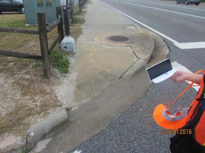
14 Location: Corridor-Wide Issue #6: Driveways Figure 13 Figure 14 Description of Issue: At some driveways throughout the corridor, the sidewalk merges into the existing driveway as displayed in Figure 13 and Figure 14. At many of these locations, a level path with less than two (2) percent cross slope is not provided across the driveway. Per section R302.6 in the ADA PROWAG guidance, the maximum cross slope for a sidewalk across a driveway is two (2) percent. Along the study corridor, properties were observed as having multiple driveways onto SR A1A (Figure 13). A number of driveways were also noted to be longer than the 36 maximum driveway width (Figure 14) as specified per FDOT Standard Index 515. While there were no pedestrian/bicycle crashes at driveways, driveways are conflict points between pedestrians/bicyclists utilizing the sidewalk and vehicles exiting the property or turning from SR A1A. Suggestions for Improvement: Consider driveway reconstruction during the roadway s next 3R project to provide a level path for the sidewalk and meet ADA guidance. As part of this construction, consider reducing the driveway widths down to the 36 maximum per FDOT Standard Index 515. As properties redevelop along the corridor, consider rebuilding the driveways. It appears these improvements can be done without negatively impacting parking or site circulation on the subject parcels. To address the issue of multiple driveways for the same property, consider driveway consolidation during potential redevelopments where feasible. 12

 where the top of the inlet is raised above the sidewalk. According to section R302.7.")
 were greater than the 8.")
15 Issue #7: Sidewalk Walkability Location: Corridor-Wide Daytona Beach Section Figure 15 Figure 16 Figure 17 Description of Issue: The study team observed the following sidewalk walkability issues along the study corridor. These issues are more general in nature and applied to multiple locations. Sidewalk walkability issues related to one specific location, such as missing sidewalk, are detailed in Issue #15: Sidewalk Walkability. Trip hazards were present at multiple inlets along the corridor (Figure 15) where the top of the inlet is raised above the sidewalk. According to section R of the Americans with Disabilities Act Public Rights of Way Accessibility Guidelines (ADA PROWAG), vertical surface discontinuities shall be ½ maximum. o Specific inlets with this issue were noted south of Eastwood Lane and south of Temko Terrace. Curb ramps at minor street intersections (Figure 16) were greater than the 8.3 percent maximum running slope discussed in section R of the ADA PROWAG. There is also no turning space at the top of the ramps. According to section R of the ADA PROWAG, a turning space of 4 minimum by 4 minimum shall be provided at the top of the curb ramp. Power poles (Figure 17) and trash cans were located in the sidewalk (mainly on the east side), reducing the sidewalk width to less than the minimum 4 according to ADA PROWAG section R

16 Suggestions for Improvement: At the locations where trip hazards are present at inlets, consider beveling/grinding the inlet top near the sidewalk joint to reduce/eliminate the trip hazard. As a maintenance activity, consider moving the trash cans so they are located off the sidewalk. During the next roadway resurfacing project, consider rebuilding the curb ramps for the minor streets to meet ADA guidance and provide turning spaces at the top of the ramps. Daytona Beach Shores completed a streetscape project in 2013 where the sidewalks were rebuilt and the utilities along the corridor were put underground, as displayed in Figure 18. As a long term suggestion, consider rebuilding the sidewalk in the Daytona Beach section and underground the utilities along the corridor to remove the sidewalk obstructions. Figure 18 14


17 Location: Corridor-Wide Daytona Beach Section Issue #8: Bus Stops Figure 19 Figure 20 Description of Issue: Votran bus stops (Figure 19 and Figure 20) are present along the study corridor on both the east and west sides of the roadway. A 5 wide by 8 deep concrete landing pad is not present on the west side due to the landscape buffer strip or on the east side because the sidewalk adjacent to the curb is only 5 to 6 deep. Note the landing pad issue can be applied to most bus stops along the corridor. More specific bus stop issues relating to specific bus stop locations are discussed in Issue #14: Bus Stops. Suggestions for Improvement: Consider providing a 5 x 8 bus stop landing pad at each bus stop per section R of the ADA PROWAG during the next resurfacing project. 15
, Eastwood Lane (Figure 22), and Frances Terrace having driveway connections to SR A1A instead of paved asphalt connections.")
 percent. These minor streets did not have marked crosswalks or detectable warning surfaces.")
18 Issue #9: Minor Streets with Driveway Connections Location: Corridor-Wide Daytona Beach Section Figure 21 Figure 22 Description of Issue: The study team observed the named public minor streets of Temko Terrace (Figure 21), Eastwood Lane (Figure 22), and Frances Terrace having driveway connections to SR A1A instead of paved asphalt connections. At many of these locations, a level path with less than two (2) percent cross slope is not provided across the driveway. Per section R302.6 in the ADA PROWAG guidance, the maximum cross slope for a sidewalk across a driveway is two (2) percent. These minor streets did not have marked crosswalks or detectable warning surfaces. Suggestions for Improvement: Consider removing the driveway connection during the roadway s next 3R project and construct an asphalt connection from these minor streets to SR A1A. Doing so will provide a level path for the sidewalk and meet ADA guidance. As discussed in Issue #5: Minor Street Crosswalks and Stop Bars, consider marking the crosswalk across the minor street and restriping the stop bars. Consider installing detectable warning surfaces at the two curb ramps of the intersection per FDOT Standard Index
 is less than 7 above the sidewalk. Section 2A.")
19 Issue #10: Sidewalk Sign Obstruction Location: Mid-Block between Park Avenue and Botefuhr Avenue Figure 23 Description of Issue: The secondary sign below the Adopt-A-Highway sign just south of Park Avenue (Figure 23) is less than 7 above the sidewalk. Section 2A.18 of the MUTCD states that if a secondary sign mounted below another sign is less than 7 above the sidewalk, the sign shall not project more than 4 into the pedestrian facility. Suggestions for Improvement: Consider reinstalling the sign so the secondary sign either does not project more than 4 into the sidewalk or is greater than 7 above the sidewalk. This may be done by moving the sign off the sidewalk or installing the signs on a taller sign post. 17


20 Location: Mid-Block between Park Avenue and Botefuhr Avenue Issue #11: Sight Distance at Bahama House Figure 24 Figure 25 Description of Issue: Shrubbery is present on the corners of the Bahama House Hotel driveway, restricting sight distance between vehicles exiting onto SR A1A and sidewalk users (pedestrians/bicyclists) to the south (Figure 24) and to the north (Figure 25). Suggestions for Improvement: Consider working with the property owner to trim back or remove the shrubbery to improve sight distance between exiting vehicles and pedestrians/bicyclists approaching the driveway on the sidewalk. 18
. Pedestrians at the intersection may get confused as to which pedestrian detector to push in order to cross SR A1A.")
21 Location: Botefuhr Avenue Intersection Issue #12: Street Name Signage and Pavement Markings Figure 26 Figure 27 Description of Issue: No street name sign is present for SR A1A at the intersection (Figure 26). Pedestrians at the intersection may get confused as to which pedestrian detector to push in order to cross SR A1A. No stop bar is present on the westbound approach (east leg) at the intersection (Figure 27). One pedestrian crash occurred in the north leg crosswalk with a westbound right turning vehicle. Suggestions for Improvement: Consider installing an interior illuminated, overhead LED SR A1A street name sign at Botefuhr Avenue, per Table 2A-1 of the MUTCD. Consider striping a stop bar on the westbound approach as shown on sheet 4 of FDOT Standard Index to emphasize where the vehicle needs to stop on red. 19

22 Location: Botefuhr Avenue Intersection Issue #13: Pedestrian Facilities Figure 28 Figure 29 Figure 30 Figure 31 Figure 32 Figure 33 20
23 Description of Issue: The crosswalks were faded on the four legs of the intersection and the crosswalk striping style was inconsistent between the Botefuhr Avenue approach standard markings (Figure 28) and the SR A1A old special emphasis markings (Figure 29). One pedestrian crash occurred in the north leg crosswalk with a westbound right turning vehicle. No detectable warning surfaces were present for any of the curb ramps at the intersection (Figure 30 and Figure 31). Due to the skew of Botefuhr Avenue, crosswalks on the north and south (Figure 32) legs across SR A1A are skewed and do not align with the curb ramps on the corners of the intersection. The curb ramps were observed to be steep and did not meet the 4 minimum clear width according to ADA PROWAG section R (Figure 33). The pedestrian detector signage did not have an arrow leading to the crosswalk and the street name font was not MUTCD standard. The study team also observed the pedestrian signal head on the southwest corner for the south leg crosswalk was not working. Suggestions for Improvement: Consider re-striping the four crosswalk markings with special emphasis crosswalk markings consistent with sheet 9 of the FDOT Design Standard Index Consider installing detectable warning surfaces at the four curb ramps of the intersection per FDOT Standard Index 304. Contact the maintenance department to fix the countdown timers on the southwest corner for the south leg crosswalk. Consider realigning the north and south leg crosswalks to be more perpendicular with SR A1A. This would require constructing new curb ramps for those two crosswalks. Consider rebuilding the existing curb ramps so they meet the 4 minimum clear width as stated in the ADA PROWAG. As part of separating the curb ramps, consider individual pedestrian detector poles for each crosswalk at the intersection. Consider replacing the pedestrian detector signs with R10-3i pedestrian plaques which includes an arrow and MUTCD street name font indicating which street the pedestrian detector corresponds with. Consider implementing a leading pedestrian interval for the north and south leg crosswalks prior to the onset of the eastbound/westbound green phase. 21
.")

24 Issue #14: Bus Stops Location: Mid-Block between Botefuhr Avenue and Silver Beach Avenue Figure 34 Figure 35 Description of Issue: During the review, the study team noticed the following issues with specific bus stops along the corridor: A Votran sign was missing for the stop between Botefuhr Avenue and Flamingo Avenue on the west side of the roadway (Figure 34). Landscaping was obstructing the Votran sign between Botefuhr Avenue and Flamingo Avenue on the east side of the roadway (Figure 35). A Votran sign was missing for the stop just north of the beach access at Frazar Road on east side of the roadway. Suggestions for Improvement: As per the date of this report, Votran has worked with the City of Daytona Beach Shores to install a bus stop sign for the stop between Botefuhr Avenue and Flamingo Avenue. Consider trimming the palm tree from in front of the Votran sign on the east side between Botefuhr Avenue and Flamingo Avenue. Consider adding a Votran sign for the stop on the east side at Frazar Road. 22


25 Location: Mid-Block between Botefuhr Avenue and Silver Beach Avenue Issue #15: Sidewalk Walkability Figure 36 Figure 37 Figure 38 Figure 39 Description of Issue: The study team observed the following sidewalk walkability issues related to one specific location between Botefuhr Avenue and Silver Beach Avenue. The sidewalk was cracked and formed a small dip on the east side of the roadway north of Poinsettia Road. The speed limit sign is less than 7 above the sidewalk on the west side of the roadway north of Wisteria Road (Figure 36). Section 2A.18 of the MUTCD states the minimum height from the bottom of the sign to the sidewalk shall be 7. A trip hazard from a tie down cable on the east side of the roadway north of Wisteria Road (Figure 37). A metal pole from a previous sign was protruding from the sidewalk on the east side of the roadway near Temko Terrace. A grate for the private property on east side of the roadway is not level with sidewalk near Bostwick Avenue (Figure 38). 23
26 North of Bostwick Avenue on the west side of the roadway, the landscape buffer strip is raised approximately ½ to 1 higher than the sidewalk which does not allow for water to properly drain into the grass, thus creating ponding/sand on the sidewalk (Figure 39). One of the sidewalk panels was gravel instead of concrete on the east side of the roadway north of Bostwick Avenue. Suggestions for Improvement: Consider the following suggestions to address the sidewalk walkability issues between Botefuhr Avenue and Silver Beach Avenue: Replace the sidewalk panels that are cracked on the east side of SR A1A north of Poinsettia Road. Reinstall the speed limit sign on the west side of SR A1A north of Wisteria Road by moving the sign off the sidewalk or installing the sign on a taller sign post. Remove the tie down cable trip hazard on the east side of SR A1A north of Wisteria Road. Grind down or cut away the remaining protruding metal pole on the east side of SR A1A near Temko Terrace. Work with the property owner to install a grate that is level with the sidewalk on east side of the near Bostwick Avenue. For the sidewalk maintenance north of Bostwick Avenue on the west side of SR A1A: o Consider regular sidewalk maintenance (sweeping debris/sand) along this section. The maintenance may be scheduled regularly or may be performed after a heavy rain event. o Consider reducing the height of landscape strip to be level or just below the sidewalk and replace with new sod. The landscape strip could also be replaced with concrete to create a wider sidewalk in this area. o In lieu of regular sidewalk maintenance by a local jurisdiction, local businesses along the corridor could apply for the FDOT Adopt-A-Highway program. According to the website (found at volunteers would enter into a two-year agreement with DOT, during which they agree to conduct litter removal at regularly scheduled intervals. Many miles of highway are adopted statewide by various organizations, allowing civic-minded people to make a difference in their communities. This eases the load of DOT work crews, enabling them to devote more time to other road maintenance and special highway projects. Replace the gravel sidewalk panel on the east side of the roadway north of Bostwick Avenue with concrete. 24
 and the crosswalk striping was not retro reflective.")
 are skewed creating longer crossing distances for pedestrians.")

27 Issue #16: Pedestrian Facilities Location: Silver Beach Avenue Intersection Figure 40 Figure 41 Figure 42 Description of Issue: The crosswalks were faded on the four legs of the intersection (Figure 40) and the crosswalk striping was not retro reflective. One pedestrian crash occurred in the north leg crosswalk with an eastbound left turning vehicle. Due to the skew of Silver Beach Avenue, crosswalks on all four legs (Figure 40 and Figure 41) are skewed creating longer crossing distances for pedestrians. Pedestrian detector signage at the intersection was faded as displayed in Figure 42. Suggestions for Improvement: Consider re-striping the four crosswalk markings with special emphasis crosswalk markings consistent with sheet 9 of the FDOT Design Standard Index Consider removing the decorative pavers and research an approved roadway material that thermoplastic crosswalk markings will adhere to. Possibly redesign the intersection and change the pattern to following driving lanes. 25
28 Consider realigning the west and south leg crosswalks to be more perpendicular with Silver Beach Avenue and SR A1A. For the west crosswalk, a new curb ramp could be constructed on the south side of Silver Beach Avenue in the southwest corner of the intersection. For the south crosswalk, a new curb ramp could be constructed on the west side of SR A1A in the southwest corner of the intersection. As part of this suggestion, consider implementing a leading pedestrian interval for all four crosswalks prior to the onset of their respective conflicting green phases. The north and east crosswalks are not suggested to be moved due to the potential impacts to drainage inlets on the northeast corner of the intersection. As part of separating the curb ramps, consider individual pedestrian detector poles on the southwest corner of the intersection and building the curb ramps so they are ready for accessible pedestrian signals. Consider replacing all of the faded pedestrian detector signs with R10-3i pedestrian plaques. 26

 side of the pole that is level")
29 Issue #17: Southwest Corner Accessibility Location: Silver Beach Avenue Intersection Figure 43 Figure 44 Description of Issue: The mast arm in the southwest corner of the intersection is located within the sidewalk/curb ramp area as displayed in Figure 43 and Figure 44. Adequate 4 continuous clear width for the sidewalk is not provided based on ADA PROWAG section R Suggestions for Improvement: In order to minimize the cost for providing an accessible path around this corner, consider constructing a sidewalk on the back (west) side of the pole that is level with the height of the poles base. From field observations, this improvement may impact right-of-way for the Sunoco gas station so working with the property owner to construct this sidewalk may be needed. If the crosswalks are realigned as described in Issue #16: Pedestrian Facilities, the pedestrian detectors and signals will be on separate poles near the new ramp locations. 27
.")
.")
30 Location: Silver Beach Avenue Intersection Issue #18: Southbound Channelized Right Turn Lane Figure 45 Figure 46 Description of Issue: A marked pedestrian crosswalk is located across the channelized southbound right turn lane in the northwest corner of the intersection (Figure 45). This movement is a relatively high speed turn and the crosswalk markings are difficult to see from the driver s perspective (Figure 46). Pedestrians standing on the corner waiting to cross to the channelized island are visually obstructed by the palmetto tree (yellow circle in Figure 46). Suggestions for Improvement: To emphasize the pedestrian crosswalk across the channelized southbound right turn lane in the northwest corner, consider adding YIELD HERE FOR PEDESTRIANS (R1-5 or R1-5a) signage to both the Yield sign post on the right side of the roadway and the mast arm located in the channelized island. Yield lines could be installed per section 3B.16 of the MUTCD prior to the crosswalk to give the driver a visual in-pavement cue that they are approaching a crosswalk. Consider removing the palmetto tree on the northwest corner to improve sight distance between southbound right turning vehicles and crosswalk users. 28
.")
31 Location: Mid-Block between Silver Beach Avenue and Ribault Avenue Issue #19: Sidewalk Maintenance Figure 47 Description of Issue: Between Mobile Avenue and Phoenix Avenue, the sidewalk was observed as having walkability issues due to sand partially covering the sidewalk (Figure 47). The landscape buffer strip was raised approximately ½ to 1 higher than the sidewalk which does not allow for water to properly drain into the grass, thus creating the ponding/sand on the sidewalk. Suggestions for Improvement: Consider regular sidewalk maintenance (sweeping debris/sand) along this section. The maintenance may be scheduled regularly or may be performed after a heavy rain event. Consider reducing the height of the landscape strip to be level or just below the sidewalk and replace with new sod. The landscape strip could also be replaced with concrete to create a wider sidewalk in this area. In lieu of regular sidewalk maintenance by a local jurisdiction, local businesses along the corridor could apply for the FDOT Adopt-A-Highway program. According to the website (found at volunteers would enter into a two-year agreement with DOT, during which they agree to conduct litter removal at regularly scheduled intervals. Many miles of highway are adopted statewide by various organizations, allowing civic-minded people to make a difference in their communities. This eases the load of DOT work crews, enabling them to devote more time to other road maintenance and special highway projects. 29
32 Summary of Suggestions This pedestrian/bicycle safety review considers operational and safety related issues for pedestrians and bicyclists on SR A1A from Park Avenue to Ribault Avenue. This study was commissioned by the R2CTPO to develop suggestions to improve the safety of pedestrians and bicyclists within the study limits. Each suggestion identified in this study is classified into one of three categories: Short-Term Maintenance it is anticipated that issues identified for maintenance may be addressed by public agency staff on a short timeframe and at a relatively low cost. Near-Term Improvement activities that may be incorporated into an upcoming construction project in the area, including 3R milling and resurfacing projects. Long-Term Improvement activities that may be incorporated into upcoming construction projects and may need to be programmed for funding as separate projects. The following Short-Term Maintenance suggestions should be prioritized for implementation before the other suggestions identified in this report: Issue #7: Sidewalk Walkability on page 13 Issue #15: Sidewalk Walkability on page 23 o Replace the sidewalk panels that are cracked on the east side of SR A1A north of Poinsettia Road. o Remove the tie down cable trip hazard on the east side of SR A1A north of Wisteria Road. o Grind down or cut away the remaining protruding metal pole on the east side of SR A1A near Temko Terrace. o Work with the property owner to install a grate that is level with the sidewalk on east side of the near Bostwick Avenue. o Replace the gravel sidewalk panel on the east side of the roadway north of Bostwick Avenue with concrete. The following tables summarize the suggestions of this study by priority (maintenance, near-term, or long-term). 30
33 Location Issue Number Issue Suggestion SHORT-TERM MAINTENANCE Corridor Wide 1 Lighting Replace the lights on the corridor that are burnt out. Corridor Wide 5 Corridor Wide Daytona Beach Section Mid-Block between Park Avenue and Botefuhr Avenue Mid-Block between Park Avenue and Botefuhr Avenue Minor Street Crosswalks and Stop Bars 7 Sidewalk Walkability 10 Sidewalk Sign Obstruction 11 Botefuhr Avenue Intersection 12 Sight Distance at Bahama House Street Name Signage and Pavement Markings Botefuhr Avenue Intersection 13 Pedestrian Facilities Consider emphasizing the pedestrian realm across minor street approaches by restriping crosswalk markings as shown on sheet 9 of FDOT Standard Index Also consider restriping the stop bar as shown on sheets 2 and 4 of FDOT Standard Index to emphasize where the vehicle needs to stop before making their turning movement. Locations the study team noted during the review included: Crosswalks at Old Trail Road, Poinsettia Road, Wisteria Road, Bostwick Avenue, and Mobile Avenue; and Stop bar at Bostwick Avenue. At the locations where trip hazards are present at inlets, consider beveling/grinding the inlet top near the sidewalk joint to reduce/eliminate the trip hazard. Consider moving the trash cans so they are located off the sidewalk. Consider reinstalling the sign so the secondary sign either does not project more than 4 into the sidewalk or is greater than 7 above the sidewalk. This may be done by moving the sign off the sidewalk or installing the signs on a taller sign post. Consider working with the property owner to trim back or remove the shrubbery to improve sight distance between exiting vehicles and pedestrians/bicyclists approaching the driveway on the sidewalk. Consider installing an interior illuminated, overhead LED SR A1A street name sign at Botefuhr Avenue, per Table 2A-1 of the MUTCD. Consider striping a stop bar on the westbound approach as shown on sheet 4 of FDOT Standard Index to emphasize where the vehicle needs to stop on red. Consider re-striping the four crosswalk markings with special emphasis crosswalk markings consistent with sheet 9 of the FDOT Design Standard Index Consider installing detectable warning surfaces at the four curb ramps of the intersection per FDOT Standard Index 304. Contact the maintenance department to fix the countdown timers on the southwest corner for the south leg crosswalk. Mid-Block between Botefuhr Avenue and Silver Beach Avenue Mid-Block between Botefuhr Avenue and Silver Beach Avenue 14 Bus Stops 15 Sidewalk Walkability As per the date of this report, Votran has worked with the City of Daytona Beach Shores to install a bus stop sign for the stop between Botefuhr Avenue and Flamingo Avenue. Consider trimming the palm tree from in front of the Votran sign on the east side between Botefuhr Avenue and Flamingo Avenue. Consider adding a Votran sign for the stop on the east side at Frazar Road. Consider the following suggestions to address the sidewalk walkability issues between Botefuhr Avenue and Silver Beach Avenue: Replace the sidewalk panels that are cracked on the east side of SR A1A north of Poinsettia Road. Reinstall the speed limit sign on the west side of SR A1A north of Wisteria Road by moving the sign off the sidewalk or installing the sign on a taller sign post. Remove the tie down cable trip hazard on the east side of SR A1A north of Wisteria Road. Grind down or cut away the remaining protruding metal pole on the east side of SR A1A near Temko Terrace. Work with the property owner to install a grate that is level with the sidewalk on east side of the near Bostwick Avenue. For the sidewalk maintenance north of Bostwick Avenue on the west side of SR A1A: o Consider regular sidewalk maintenance (sweeping debris/sand) along this section. The maintenance may be scheduled regularly or may be performed after a heavy rain event. o Consider reducing the height of landscape strip to be level or just below the sidewalk and replace with new sod. The landscape strip could also be replaced with concrete to create a wider sidewalk in this area. o In lieu of regular sidewalk maintenance by a local jurisdiction, local businesses along the corridor could apply for the FDOT Adopt-A-Highway program. Replace the gravel sidewalk panel on the east side of the roadway north of Bostwick Avenue with concrete. 31
34 Location Issue Number Issue Suggestion SHORT-TERM MAINTENANCE Silver Beach Avenue 16 Pedestrian Facilities Consider re-striping the four crosswalk markings with special emphasis crosswalk markings consistent with sheet 9 of the FDOT Design Standard Index Research and install an approved thermoplastic material that will maintain adhesiveness to the colored pavement at the intersection. Consider replacing all of the faded pedestrian detector signs with R10-3i pedestrian plaques. To emphasize the pedestrian crosswalk across the channelized southbound right turn lane in the northwest corner, consider adding YIELD HERE FOR PEDESTRIANS (R1-5 or R1-5a) signage to both the Yield sign post on the right side of the roadway and the mast Silver Beach Avenue 18 Consider removing the palmetto tree on the northwest corner to improve sight distance between southbound right turning vehicles and crosswalk users. Southbound Channelized arm located in the channelized island. Yield lines could be installed per section 3B.16 of the MUTCD prior to the crosswalk to give Right Turn Lane the driver a visual in-pavement cue that they are approaching a crosswalk. Mid-Block between Silver Beach Avenue and Ribault Avenue 19 Sidewalk Maintenance Consider regular sidewalk maintenance (sweeping debris/sand) along this section. The maintenance may be scheduled regularly or may be performed after a heavy rain event. Consider reducing the height of the landscape strip to be level or just below the sidewalk and replace with new sod. The landscape strip could also be replaced with concrete to create a wider sidewalk in this area. In lieu of regular sidewalk maintenance by a local jurisdiction, local businesses along the corridor could apply for the FDOT Adopt-A- Highway program. 32
35 Location Issue Number Issue Suggestion NEAR-TERM IMPROVEMENT Corridor Wide 1 Lighting The following are considerations for lighting along the corridor: Consider conducting field measurements of existing lighting levels to evaluate lighting uniformity levels and add lighting where necessary. Consider light poles on the east side that are angled westerly away from the beach. These light poles cast their light to the west and illuminate the roadway as needed. The light bulb is not seen by the turtles due to the angle and orientation of the light fixture. Consider implementing a lighting plan for the time the sea turtle nesting season is not active as roadway lighting levels should not be reduced at this time. Consider implementation of pedestrian-level lighting, with less visibility from the beach, to supplement areas where street lighting is not able to provide adequate lamination. The following locations could be considered for mid-block crossing locations: Near the beach access just south of the Holiday Inn Resort, between Ocean Dunes Road and Old Trail Road. Two bus stops are located in this block and it would be approximately 1/4 to 1/3 of a mile north of the Botefuhr Avenue signal. Near the beach access just south of the Catalina Beach Club, between Temko Terrace and Bostwick Avenue. Two pedestrian crossing crashes occurred in this section and bus stops are located along this segment. This crossing would be approximately 1/4 mile north of the above suggestion and approximately 0.15 to 0.20 miles south of Silver Beach Avenue. Near the beach access just south of where the new Hard Rock Hotel is planning to be constructed, between Frances Terrace and Ribault Avenue. Bus stops are present within this segment and it would be approximately 0.15 to 0.20 miles north of the Silver Beach Avenue signal. Corridor Wide 2 Mid-Block Crossings Corridor Wide 3 Lighting at Signalized Intersections Corridor Wide 4 Lack of Bicycle Facilities The following suggestions should be considered at select locations where a mid-block crossing is desired and warranted: Conduct a mid-block crossing study per Section 3.8 of the FDOT Traffic Engineering Manual (TEM) to evaluate if a crosswalk is warranted based upon existing demands. o Ideal locations would be where a beach access is located across the street from commercial development, where a hotel/major land use generator on the east side has parking on the west side, or where bus stops are located near beach access points or major land use generators along the corridor. o As land uses along the corridor develop/redevelop, evaluate if a mid-block crossing is feasible. Consider an active warning device, such as Rapid Rectangular Flashing Beacons (RRFB), at the crosswalk. Provide a median refuge island with a minimum length of 90 feet for pedestrians in the TWLTL. Install lighting at the crosswalk. o Directional lighting oriented towards the crosswalk could be provided; or o Lighting could turn on when the RRFB is activated and flashing and could turn off when the flashers stop. Stripe the crosswalk with special emphasis crosswalk markings consistent with sheet 10 of the FDOT Design Index Consider upgrading the lighting at the two intersections to meet the requirements of section in Volume 1 of the FDOT Plans Preparation Manual (PPM). This may require the existing lighting to be replaced. FDOT is also considering lighting installed underneath mast arms that hang directly over marked crosswalks at signalized intersections. These two options should be evaluated to see which best meets the lighting requirements for each intersection. Because right-of-way is not available to provide a bicycle lane or paved shoulder, consider posting BIKES MAY USE FULL LANE (R4-11) signs along the study corridor to encourage bicycles to use the street rather than the sidewalks. Because the posted speed along this section of SR A1A is 35 MPH, consider installing shared lane markings (sharrows) in addition to the R4-11 signs, as specified on pages 1 and 2 of FDOT Standard Index
36 Location Issue Number Issue Suggestion NEAR-TERM IMPROVEMENT Corridor Wide Daytona Beach Consider providing a 5 x 8 bus stop landing pad at each bus stop per section R of the ADA PROWAG during the next 8 Bus Stops Section resurfacing project. Consider realigning the north and south leg crosswalks to be more perpendicular with SR A1A. This would require constructing new curb ramps for those two crosswalks. Consider rebuilding the existing curb ramps so they meet the 4 minimum clear width as stated in the ADA PROWAG. Botefuhr Avenue Intersection 13 Pedestrian Facilities As part of separating the curb ramps, consider individual pedestrian detector poles for each crosswalk at the intersection. Consider replacing the pedestrian detector signs with R10-3i pedestrian plaques which includes an arrow and MUTCD street name font indicating which street the pedestrian detector corresponds with. Consider implementing a leading pedestrian interval for the north and south leg crosswalks prior to the onset of the eastbound/westbound green phase. Silver Beach Avenue 16 Pedestrian Facilities Consider realigning the west and south leg crosswalks to be more perpendicular with Silver Beach Avenue and SR A1A. For the west crosswalk, a new curb ramp could be constructed on the south side of Silver Beach Avenue in the southwest corner of the intersection. For the south crosswalk, a new curb ramp could be constructed on the west side of SR A1A in the southwest corner of the intersection. As part of this suggestion, consider implementing a leading pedestrian interval for all four crosswalks prior to the onset of their respective conflicting green phases. The north and east crosswalks are not suggested to be moved due to the potential impacts to drainage inlets on the northeast corner of the intersection. As part of separating the curb ramps, consider individual pedestrian detector poles on the southwest corner of the intersection and building the curb ramps so they are ready for accessible pedestrian signals. Consider constructing a sidewalk on the back (west) side of the pole that is level with the height of the poles base. From field Silver Beach Avenue 17 pedestrian detectors and signals will be on separate poles near the new ramp locations. Southwest Corner observations, this improvement may impact right-of-way for the Sunoco gas station so working with the property owner to Accessibility construct this sidewalk may be needed. If the crosswalks are realigned as described in Issue #16: Pedestrian Facilities, the 34
37 Location Issue Number Issue Suggestion LONG-TERM IMPROVEMENT Corridor Wide 1 Lighting Consider upgrading to an adaptive roadway lighting system along the corridor. Lighting levels could be programmed to be reduced during the sea turtle nesting season and increased to normal levels outside of the nesting season. This could be coupled with replacing the current high pressure sodium lighting with LED lighting. Corridor Wide 6 Driveways Consider driveway reconstruction during the roadway s next 3R project to provide a level path for the sidewalk and meet ADA guidance. As part of this construction, consider reducing the driveway widths down to the 36 maximum per FDOT Standard Index 515. As properties redevelop along the corridor, consider rebuilding the driveways. It appears these improvements can be done without negatively impacting parking or site circulation on the subject parcels. To address the issue of multiple driveways for the same property, consider driveway consolidation during potential redevelopments where feasible. During the next roadway resurfacing project, consider rebuilding the curb ramps for the minor streets to meet ADA guidance and provide turning spaces at the top of the ramps. Corridor Wide Daytona Beach 7 Sidewalk Walkability Daytona Beach Shores completed a streetscape project in 2013 where the sidewalks were rebuilt and the utilities along the Section corridor were put underground. Consider rebuilding the sidewalk in the Daytona Beach section and underground the utilities along the corridor to remove the sidewalk obstructions. Corridor Wide Daytona Beach Section 9 Minor Streets with Driveway Connections Consider removing the driveway connection during the roadway s next 3R project and construct an asphalt connection from these minor streets to SR A1A. Doing so will provide a level path for the sidewalk and meet ADA guidance. As discussed in Issue #5: Minor Street Crosswalks and Stop Bars, consider marking the crosswalk across the minor street and restriping the stop bars. Consider installing detectable warning surfaces at the two curb ramps of the intersection per FDOT Standard Index
38 Appendix A Crash Analysis Reference Materials


39 SR/CR A1A Pedestrian Safety & Mobility Study Crash Type Pedestrian Crash Bicycle Crash Treasure Island Inn SR/CR A1A Pedestrian Safety & Mobility Study Collision Diagram ( ) Location B: Sunrise Blvd. to Park Ave. Figure 1


40 SR/CR A1A Pedestrian Safety & Mobility Study Crash Type Pedestrian Crash Bicycle Crash Ocean Vistas Condominiums SR/CR A1A Pedestrian Safety & Mobility Study Collision Diagram ( ) Location B: Park Ave. to Flamingo Ave. Figure 2


41 SR/CR A1A Pedestrian Safety & Mobility Study Crash Type Pedestrian Crash Ocean Holiday Motel Bicycle Crash Sunoco Gas Station SR/CR A1A Pedestrian Safety & Mobility Study Collision Diagram ( ) Location B: Flamingo Ave. to Frazar Ave. Figure 3


42 SR/CR A1A Pedestrian Safety & Mobility Study Crash Type Pedestrian Crash Bicycle Crash Holiday Inn 7 Eleven SR/CR A1A Pedestrian Safety & Mobility Study Collision Diagram ( ) Location B: Frazar Ave. to Old Trail Rd. Figure 4


")


43 SR/CR A1A Pedestrian Safety & Mobility Study Crash Type Pedestrian Crash Bicycle Crash Oyster Bar Rodeway Inn SR/CR A1A Pedestrian Safety & Mobility Study Collision Diagram ( ) Location B: Old Trail Rd. to Tempko Terr. Figure 5


44 SR/CR A1A Pedestrian Safety & Mobility Study Crash Type Pedestrian Crash Bicycle Crash Sea Dip Beach Resort Catalina Beach Club SR/CR A1A Pedestrian Safety & Mobility Study Collision Diagram ( ) Location B: Tempko Terr. To Bostwick Ave. Figure 6


45 SR/CR A1A Pedestrian Safety & Mobility Study Crash Type Pedestrian Crash Bicycle Crash 1 1 Silver Beach Club Sunoco Gas Station 1 1 SR/CR A1A Pedestrian Safety & Mobility Study Collision Diagram ( ) Location B: Bostwick Ave. to Phoenix Ave. Figure 7


46 SR/CR A1A Pedestrian Safety & Mobility Study Crash Type Pedestrian Crash Bicycle Crash 7 Eleven Silver Beach Club SR/CR A1A Pedestrian Safety & Mobility Study Collision Diagram ( ) Location B: Phoenix Ave. to Ribault Ave. Figure 8
SR/CR A1A PEDESTRIAN SAFETY & MOBILITY STUDY
 SR/CR AA PEDESTRIAN SAFETY & MOBILITY STUDY PEDESTRIAN / BICYCLE SAFETY REVIEW Focus Area H / 9th Street S to 3th Street N Prepared for: River to Sea Transportation Planning Organization 2570 West International
SR/CR A1A PEDESTRIAN SAFETY & MOBILITY STUDY
 SR/CR A1A PEDESTRIAN SAFETY & MOBILITY STUDY PEDESTRIAN / BICYCLE SAFETY REVIEW Focus Area E / Sandcastle Drive to Holland Road (Ormond Beach/Ormond-by-the-Sea) Prepared for: River to Sea Transportation
APPENDIX A: Complete Streets Checklist DRAFT NOVEMBER 2016
 APPENDIX A: Complete Streets Checklist DRAFT NOVEMBER 2016 Complete Streets Checklist MetroPlan Orlando s Complete Streets Checklist is an internal planning tool for staff to further implementation of
SR/CR A1A PEDESTRIAN SAFETY & MOBILITY STUDY RIVER TO SEA TRANSPORTATION PLANNING ORGANIZATION
 SR/CR A1A PEDESTRIAN SAFETY & MOBILITY STUDY RIVER TO SEA TRANSPORTATION PLANNING ORGANIZATION 2016 Florida Section ITE Annual Summer Meeting June 24, 2016 Today s Presenters Lois Bollenback Executive
PEDESTRIAN / BICYCLE SAFETY REVIEW
 PEDESTRIAN / BICYCLE SAFETY REVIEW Palm Bay Road from Babcock Street to Lipscomb Street Prepared for: Space Coast Transportation Planning Organization 2725 Judge Fran Jamieson Way Bldg. B / Room 05 / MS
City of Albert Lea Policy and Procedure Manual 4.10 ALBERT LEA CROSSWALK POLICY
 4.10 ALBERT LEA CROSSWALK POLICY PURPOSE: Pedestrian crosswalks are an integral part of our transportation infrastructure. To be effective and promote safety, marked crosswalks must be installed after
NJDOT Complete Streets Checklist
 Background The New Jersey Department of Transportation s Complete Streets Policy promotes a comprehensive, integrated, connected multi-modal network by providing connections to bicycling and walking trip
Active Transportation Facility Glossary
 Active Transportation Facility Glossary This document defines different active transportation facilities and suggests appropriate corridor types. Click on a facility type to jump to its definition. Bike
PEDESTRIAN / BICYCLE SAFETY REVIEW
 PEDESTRIAN / BICYCLE SAFETY REVIEW SR 50 / Clearlake Road from Dixon Boulevard to Michigan Avenue Prepared for: Space Coast Transportation Planning Organization 2725 Judge Fran Jamieson Way Bldg. B / Room
FLORIDA DEPARTMENT OF TRANSPORTATION DISTRICT 7 DISTRICT WIDE BICYCLE/PEDESTRIAN ACCESS TO TRANSIT SAFETY ASSESSMENT AND IMPROVEMENT PLAN
 FLORIDA DEPARTMENT OF TRANSPORTATION DISTRICT 7 DISTRICT WIDE BICYCLE/PEDESTRIAN ACCESS TO TRANSIT SAFETY ASSESSMENT AND IMPROVEMENT PLAN TRANSIT SAFETY ASSESSMENT SR 55/US 19 AT 80 TH AVE N DRAFT JUNE
Appendix 3 Roadway and Bike/Ped Design Standards
 Appendix 3 Roadway and Bike/Ped Design Standards OTO Transportation Plan 2040 4/20/2017 Page A3-1 Adopted Standards The adopted OTO Design Standards and Major Thoroughfare Plan are contained herein.
Pedestrian Road Safety Audit
 Pedestrian Road Safety Audit Middlebrook Road From Father Hurley Boulevard to Waring Station Road December 2017 Montgomery County Department of Transportation Table of Contents 1. Introduction... 1 1.1
ADA & Public Rights of Way
 ADA & Public Rights of Way Overview of Current and Up-coming Requirements FDOT Design Training Expo 2012 Orlando, FL Dean Perkins, RA - ADA Coordinator Florida Department of Transportation Office of Design,
F L E T C H E R A V E N U E
 Jan. 29, 2014 Introduction F L E T C H E R A V E N U E FDOT Local Agency Program (LAP) Project FPN: 428214-1-58-01 CIP 63090 Hillsborough County, Traffic Engineering, PWD Stake holders and partners are
Orange Center Elementary School
 Drag and drop pic and stretch/crop to the limits of the blue rectangle (delete this text box) Orange Center Elementary School Drag and drop pic and stretch/crop to the limits of the blue rectangle (delete
Appendix A: Crosswalk Policy
 Appendix A: Crosswalk Policy Appendix A: Crosswalk Policy Introduction This citywide Crosswalk Policy is aimed at improving pedestrian safety and enhancing pedestrian mobility by providing a framework
Off-road Trails. Guidance
 Off-road Trails Off-road trails are shared use paths located on an independent alignment that provide two-way travel for people walking, bicycling, and other non-motorized users. Trails specifically along
PEDESTRIAN SAFETY IMPROVEMENT EVALUATION GUIDELINE FOR UNCONTROLLED CROSSINGS
 PEDESTRIAN SAFETY IMPROVEMENT EVALUATION GUIDELINE FOR UNCONTROLLED CROSSINGS Traffic Safety Engineering Division Updated: April 2018 EXECUTIVE SUMMARY NDOT Traffic Safety Engineering Division developed
Appendix T CCMP TRAIL TRAFFIC & TRANSPORTATION DESIGN STANDARD
 Appendix T CCMP 3.3.4 TRAIL TRAFFIC & TRANSPORTATION DESIGN STANDARD 3.3.4 Trail Traffic and Transportation Design Multi-use trails have certain design standards, which vary depending on the agency that
Meadow Woods Elementary School
 Drag and drop pic and stretch/crop to the limits of the blue rectangle (delete this text box) Meadow Woods Elementary School Drag and drop pic and stretch/crop to the limits of the blue rectangle (delete
Final Sidewalk Feasibility Study
 Garfield Drive From Anastasia Drive to Elizabeth Place City of South Daytona July 23, 2009 Final Sidewalk Feasibility Study Prepared for: Prepared by: Final Sidewalk Feasibility Study Garfield Drive 2
Chapter 5: Crossing the Street
 Chapter 5: Crossing the Street Whether walking or bicycling, a student s journey to school will more than likely require crossing one or more streets. Per the Safe Routes to School Guide, maintained by
LANE ELIMINATION PROJECTS
 PRESENTATION OUTLINE Lane Elimination Considerations Districts 4 & 7 Draft Lane Elimination Processes FDOT Lane Elimination Guidelines Example Projects D4 Case Study: SR A1A (Ft. Lauderdale) D7 Case Study:
CURBSIDE ACTIVITY DESIGN
 5 CURBSIDE ACTIVITY DESIGN This chapter provides design guidance for separated bike lanes adjacent to curbside activities including parking, loading and bus stops. Typical configurations are presented
12/4/2016 VIA . RE: Grocery Outlet Del Paso (DR16-328)
") 12/4/2016 VIA EMAIL Ethan Meltzer, Assistant Planner City of Sacramento Community Development Department 300 Richards Blvd, 3 rd Floor Sacramento, CA 95811 RE: Grocery Outlet Del Paso (DR16-328) Dear Mr.
12/4/2016 VIA EMAIL Ethan Meltzer, Assistant Planner City of Sacramento Community Development Department 300 Richards Blvd, 3 rd Floor Sacramento, CA 95811 RE: Grocery Outlet Del Paso (DR16-328) Dear Mr.
Hidden Oaks Elementary School
 Hidden Oaks Elementary School SCHOOL ROUTE PLAN For HIDDEN OAKS ELEMENTARY SCHOOL LOCATION 13 ORANGE COUNTY Prepared for: ORANGE COUNTY SCHOOL ASSESSMENT PROGRAM ORANGE COUNTY PUBLIC WORKS Traffic Engineering
5. RUNNINGWAY GUIDELINES
 5. RUNNINGWAY GUIDELINES These guidelines should be considered collectively when making runningway decisions. A runningway is the linear component of the transit system that forms the right-of-way reserved
What Is a Complete Street?
 Session 5 Charleen Zimmer, AICP, Zan Associates May 5-7, 2010 What Is a Complete Street? May 2010 5-1 Not a Complete Street More of a Complete Street May 2010 5-2 Benefits of Complete Streets Safety for
PEDESTRIAN SAFETY STUDY
 PEDESTRIAN SAFETY STUDY SR 699 (BLIND PASS RD/GULF BLVD) FROM 93 RD AVENUE TO PINELLAS BAYWAY PINELLAS COUNTY SECTION NO.: 15100 MILEPOST: 0.111 3.569 STUDY LIMITS Prepared For: Florida Department of Transportation
Road Diets FDOT Process
 Florida Department of TRANSPORTATION Road Diets FDOT Process Humberto Castillero, PE, PTOE Roadway Design Office Purpose of Guide Develop a statewide lane elimination review process Balance state & local
Draft North Industrial Area-Wide Traffic Plan
 Summary of North Industrial and Hudson Bay Industrial Recommended Improvements Table 1. Summary of s Item Location 1 2 3 4 5 6 7 8 9 10 11 12 Millar Ave north of 51st St Super 8 Motel back lane 400 Block
CONNECTIVITY PLAN. Adopted December 5, 2017 City of Virginia Beach
 CONNECTIVITY PLAN Adopted December 5, 2017 City of Virginia Beach CONTENTS 1.0 Background & Purpose... 2 2.0 Existing Inventory & Analysis... 3 ViBe District Existing Walking Conditions... 4 3.0 ViBe District
Roadway Classification Design Standards and Policies. Pueblo, Colorado November, 2004
 Roadway Classification Design Standards and Policies Pueblo, Colorado November, 2004 Table of Contents Page Chapter 1. General Provisions 1.1 Jurisdiction 3 1.2 Purpose and Intent 3 1.3 Modification 3
Multi-Modal Traffic Analysis. Parisi and Associates
 Mill Valley to Corte Madera Bicycle and Pedestrian Corridor Study Appendix D: Multi-Modal Traffic Analysis Prepared by Parisi and Associates August 2009 Appendix D - Multi-Modal Traffic Analysis Table
Ottawa Beach Road Study
 Ottawa Beach Road Study Prepared For: Park Township September 30, 2014 Project No. G140303 OTTAWA BEACH ROAD STUDY PREPARED FOR: PARK TOWNSHIP SEPTEMBER 30, 2014 PROJECT NO. G140303 TABLE OF CONTENTS 1.0
TRAFFIC ACTION PLAN. Laurie Meadows Neighborhood CITY OF SAN MATEO
 TRAFFIC ACTION PLAN Laurie Meadows Neighborhood CITY OF SAN MATEO Draft January 2017 Table of Contents Introduction... 2 The Traffic Forum Process... 5 Neighborhood Traffic Issues... 7 Neighborhood Recommendations
Pine Hills Road Pedestrian/Bicycle Safety Study Board of County Commissioners Work Session
 Pine Hills Road Pedestrian/Bicycle Safety Study Board of County Commissioners Work Session February 20, 2018 Meeting Agenda Study Overview Existing Conditions Access Management Potential Gateway Features
CITY OF SARATOGA SPRINGS PEDESTRIAN CROSSING TOOLBOX
 CITY OF SARATOGA SPRINGS PEDESTRIAN CROSSING TOOLBOX This toolbox is to be used to guide pedestrian crossing improvements within the City of Saratoga Springs. Details for each crossing type are provided.
MEMORANDUM. Date: 9/13/2016. Citywide Crosswalk Policy
 MEMORANDUM Date: 9/13/2016 Re: Citywide Crosswalk Policy Foreword Through the s Circulation Element and Complete Streets Policy, it is the City s goal to promote walking trips and provide safe facilities
Windy Ridge Elementary School
 Windy Ridge Elementary School SCHOOL ROUTE PLAN For WINDY RIDGE ELEMENTARY SCHOOL LOCATION 54 ORANGE COUNTY Prepared for: ORANGE COUNTY SCHOOL ASSESSMENT PROGRAM ORANGE COUNTY PUBLIC WORKS Traffic Engineering
REGIONAL BICYCLE AND PEDESTRIAN DESIGN GUIDELINES
 REGIONAL BICYCLE AND PEDESTRIAN DESIGN GUIDELINES November 16, 2011 Deb Humphreys North Central Texas Council of Governments Bicycle and Pedestrian Advisory Committee Snapshot of the Guide 1. Introduction
On Road Bikeways Part 1: Bicycle Lane Design
 On Road Bikeways Part 1: Bicycle Lane Design Presentation by: Nick Jackson Bill Schultheiss, P.E. September 04, 2012 FOLLOW THE CONVERSATION ON TWITTER Toole Design Group is live tweeting this webinar
Lynchburg District Update
 Lynchburg District Update Virginia Statewide Bicycle and Pedestrian Advisory Committee Spring Meeting May 16 th, 2017 David Cook Transportation Planner, VDOT Lynchburg District Table of Contents Active
INDOT Complete Streets Guideline & Policy
 INDOT Complete Streets Guideline & Policy INTRODUCTION The Complete Streets guidelines build upon multiple efforts and promote a multimodal transportation system that is integrated and sustains land use
ROUNDABOUTS/TRAFFIC CIRCLES
 GENERAL 1. Description This standard identifies minimum requirements that shall be met for Roundabouts and Neighborhood Traffic Circles in the design and construction of elements for Arlington County Horizontal
Morristown, NJ Complete Streets Policy
 Morristown, NJ Complete Streets Policy Introduction A Complete Street is defined as a means to provide safe access for all users by designing and operating a comprehensive, integrated, connected multi-modal
Transportation Planning Division
 Transportation Planning Division Presentation Outline Study Tasks Recap of Previous Meetings Data Collected Focus Areas within Study Limits Design Principles Tool Box Recommended Concepts Schedule Moving
AGENDA ITEM 6 D THOMASVILLE ROAD (HERMITAGE BOULEVARD TO LIVE OAK PLANTATION ROAD) ROADWAY SAFETY AUDIT
 ROADWAY SAFETY AUDIT") May 15, 2018 AGENDA ITEM 6 D THOMASVILLE ROAD (HERMITAGE BOULEVARD TO LIVE OAK PLANTATION ROAD) ROADWAY SAFETY AUDIT TYPE OF ITEM: Discussion STATEMENT OF ISSUE The Florida Department of Transportation
May 15, 2018 AGENDA ITEM 6 D THOMASVILLE ROAD (HERMITAGE BOULEVARD TO LIVE OAK PLANTATION ROAD) ROADWAY SAFETY AUDIT TYPE OF ITEM: Discussion STATEMENT OF ISSUE The Florida Department of Transportation
Chapter 2: Standards for Access, Non-Motorized, and Transit
 Standards for Access, Non-Motorized, and Transit Chapter 2: Standards for Access, Non-Motorized, and Transit The Washtenaw County Access Management Plan was developed based on the analysis of existing
Agenda. Overview PRINCE GEORGE S PLAZA METRO AREA PEDESTRIAN PLAN
 PRINCE GEORGE S PLAZA METRO AREA PEDESTRIAN PLAN May 28, 2008 Agenda Welcome and introductions Project overview and issue identification Planning context and strengths Design challenges and initial recommendations
Coquitlam Cross-town Bike Route Improving Bicycle Facilities in a Mature Suburban Environment
 Coquitlam Cross-town Bike Route Improving Bicycle Facilities in a Mature Suburban Environment Sarah Rocchi, Vice-President, Projects, Opus International Consultants (Main Presenter) Catherine Mohoruk,
DISTRIBUTION: Electronic Recipients List TRANSMITTAL LETTER NO. (17-01) MINNESOTA DEPARTMENT OF TRANSPORTATION. MANUAL: Road Design English Manual
 MINNESOTA DEPARTMENT OF TRANSPORTATION. MANUAL: Road Design English Manual") DISTRIBUTION: Electronic Recipients List MINNESOTA DEPARTMENT OF TRANSPORTATION DEVELOPED BY: Design Standards Unit ISSUED BY: Office of Project Management and Technical Support TRANSMITTAL LETTER NO.
DISTRIBUTION: Electronic Recipients List MINNESOTA DEPARTMENT OF TRANSPORTATION DEVELOPED BY: Design Standards Unit ISSUED BY: Office of Project Management and Technical Support TRANSMITTAL LETTER NO.
Section 9A.07 Meaning of Standard, Guidance, Option, and Support
 2012 Edition Page 895 PART 9. TRAFFIC CONTROLS FOR BICYCLE FACILITIES CHAPTER 9A. GENERAL Section 9A.01 Requirements for Bicyclist Traffic Control Devices 01 General information and definitions concerning
Cycle Track Design Best Practices Cycle Track Sections
 Design Best Practices Sections It is along street segments where the separation and protection methods of cycle tracks offer more comfort than conventional bicycle lanes, and are more attractive to a wide
ADA Training Accessible Pedestrian Signal (APS) 2018 MnDOT
 2018 MnDOT") ADA Training Accessible Pedestrian Signal (APS) 2018 MnDOT APS and ADA APS is not currently an ADA Standard and is provided at the discretion of the Title II entity APS is recognized in the MnMUTCD, but
ADA Training Accessible Pedestrian Signal (APS) 2018 MnDOT APS and ADA APS is not currently an ADA Standard and is provided at the discretion of the Title II entity APS is recognized in the MnMUTCD, but
Drag and drop pic and stretch/crop to the limits of the blue rectangle (delete this text box) Maxey Elementary School
 Maxey Elementary School") Drag and drop pic and stretch/crop to the limits of the blue rectangle (delete this text box) Maxey Elementary School SCHOOL ROUTE PLAN For MAXEY ELEMENTARY SCHOOL LOCATION 33 ORANGE COUNTY Prepared for:
Drag and drop pic and stretch/crop to the limits of the blue rectangle (delete this text box) Maxey Elementary School SCHOOL ROUTE PLAN For MAXEY ELEMENTARY SCHOOL LOCATION 33 ORANGE COUNTY Prepared for:
KIETZKE LANE SAFETY MANAGEMENT PLAN FINAL REPORT August, 2013 Submitted By: Parsons. Submitted to:
 KIETZKE LANE SAFETY MANAGEMENT PLAN FINAL REPORT August, 2013 Submitted By: Parsons Submitted to: KIETZKE LANE SAFETY MANAGEMENT PLAN EXECUTIVE SUMMARY The Nevada Department of Transportation (NDOT) has
Chapter 3.3 Horizon Elementary School. Volusia County MPO. June 2009
 Chapter 3.3 Horizon Elementary School Port Orange, FL Volusia County MPO June 2009 Volusia County MPO School Bicycle and Pedestrian Review Study, Phase 3C School Summary Horizon Elementary School is located
Appendix A. Knoxville TPO Greenway Signage Guidelines. Appendix A: Knoxville TPO Greenway Signage Guidelines Knox to Oak Ridge Greenway Master Plan
 Appendix A Knoxville TPO Greenway Signage Guidelines 75 Overview: Adequate signing and marking are essential on shared-use paths, especially to alert bicyclists to potential conflicts and to convey regulatory
Emerson Drive/Minton Road/Palm Bay Road from Jupiter Boulevard to Culver Drive
 ROAD SAFETY AUDIT Emerson Drive/Minton Road/Palm Bay Road from Jupiter Boulevard to Culver Drive Prepared for: Space Coast Transportation Planning Organization 75 Judge Fran Jamieson Way Bldg. B / Room
Pedestrian Crossing Guidelines 2016
 Pedestrian Crossing Guidelines 2016 Engineering Services 1.0 Introduction and Background The City of Kingston s first Pedestrian Crossing Guidelines were approved by Council in 2008 in order to provide
Chapter 3.9 Timbercrest Elementary School. Volusia County MPO. November 2008
 Chapter 3.9 Timbercrest Elementary School Deltona, FL Volusia County MPO November 2008 Volusia County MPO School Bicycle and Pedestrian Review Study, Phase 3B School Summary Timbercrest Elementary School
CTDOT Pedestrian and Bicycle Safety Initiatives
 CTDOT Pedestrian and Bicycle Safety Initiatives 2017 Northeast Transportation Safety Conference Mark F. Carlino, P.E. Traffic Engineering Division Chief Bureau of Engineering and Construction Connecticut
6/22/2018 VIA . Darcy Goulart, Planning Manager City of Rancho Cordova Planning Department 2729 Prospect Park Drive Rancho Cordova, CA 95670
 6/22/2018 VIA EMAIL Darcy Goulart, Planning Manager City of Rancho Cordova Planning Department 2729 Prospect Park Drive Rancho Cordova, CA 95670 RE: Quick Quack Car Wash (DD9801) Dear Ms. Goulart: WALKSacramento
CITY OF COCOA BEACH 2025 COMPREHENSIVE PLAN. Section VIII Mobility Element Goals, Objectives, and Policies
 CITY OF COCOA BEACH 2025 COMPREHENSIVE PLAN Section VIII Mobility Element Goals, Objectives, and Policies Adopted August 6, 2015 by Ordinance No. 1591 VIII MOBILITY ELEMENT Table of Contents Page Number
City of Scotts Valley CITY COUNCIL STAFF REPORT
 DATE: April 19, 2017 City of Scotts Valley CITY COUNCIL STAFF REPORT AGENDA ITEM 2 DATE: 4-19-2017 TO: FROM: APPROVED: SUBJECT: Honorable Mayor and City Council Scott Hamby, Public Works Director Jenny
MAG Town of Cave Creek Bike Study Task 6 Executive Summary and Regional Significance Report
 Page 1 MAG Town of Cave Creek Bike Study Task 6 Executive Summary and Regional Significance Report August 1, 2012 MAG Project #481 Page 2 Task 6 Executive Summary and Regional Significance Report Introduction
Item to be Addressed Checklist Consideration YES NO N/A Required Description Complete Streets Guidelines
 Passaic County Complete Streets Checklist - Concept Development Project Name Item to be Addressed Checklist Consideration YES NO N/A Required Description Complete Streets Guidelines Existing Plans Have
Citywide Sidewalk and Crosswalk Programs
 Citywide Sidewalk and Crosswalk Programs Council Meeting October 20, 2015 Presented by Rita Hu and Jamal Mahmoud Program Goals Implement the City s comprehensive plan. Provide pedestrian with safe walking
This page intentionally left blank.
 This page intentionally left blank. COMMUNITY Coweta Community Overview Coweta Coweta, a residential community located in Wagoner County, is a suburb of Tulsa situated southeast of the metropolitan area
Typical Cross Section: DOWNTOWN (Observer Highway - 8th Street)
") Typical Cross Section: DOWNTOWN (Observer Highway - 8th Street) DRAFT SEPTEMBER 23, 14 1 Washington Street Typical Block Downtown Typical Block: DOWNTOWN (Observer Highway - 8th Street) New crosswalks
Typical Cross Section: DOWNTOWN (Observer Highway - 8th Street) DRAFT SEPTEMBER 23, 14 1 Washington Street Typical Block Downtown Typical Block: DOWNTOWN (Observer Highway - 8th Street) New crosswalks
Complete Streets Funding Program Project Prioritization Plan
 Funding Program Project Prioritization Plan Location and Type Needs South Street Crosswalk Installation Stripe a new formalized crosswalk across South Street at the Anne T. Dunphy School pedestrian path
Broad Street Bicycle Boulevard Design Guidelines
 Broad Street Bicycle Boulevard Design Guidelines Building from the strategies introduced in the 2013 Bicycle Transportation Plan and community input received thus far, City Transportation Staff have identified
St. Francis Drive through the City of Santa Fe Corridor Study
 VII. ENGINEERING AND ENVIRONMENTAL EVALUATION TRAIL CONNECTIVITY In the southern portion of the Corridor there is a lack of a sidewalk, trail or bicycle facility within the right-ofway. However, the City
PEDESTRIAN SAFETY ASSESSMENT SR 934/NORMANDY DRIVE AND 71 Street
 PEDESTRIAN SAFETY ASSESSMENT SR 934/NORMANDY DRIVE AND 71 Street PRESENTED BY MISLEIDYS LEON TRAFFIC SAFETY PROGRAM ENGINEER FLORIDA DEPARTMENT OF TRANSPORTATION (FDOT) BACKGROUND In response to citizen
County of Greenville South Carolina. Traffic Calming Program Neighborhood Traffic Education Program and Speed Hump Program
 County of Greenville South Carolina Traffic Calming Program Neighborhood Traffic Education Program and Speed Hump Program (rev) August 2008 I. PURPOSE The potential negative impacts from vehicular traffic
Hennepin County Pedestrian Plan Public Comment Report
 Hennepin County Pedestrian Plan Public Comment Report On May 31, 2013, the draft Hennepin County Pedestrian Plan was released for a 45-day public comment period ending July 15, 2013. The county received
Transportation Policy Manual
 March 4, 2013 EXHIBIT 2 Metropolitan Transportation Planning Organization for the Gainesville Urbanized Area A Comprehensive Guide to Adopted Metropolitan Transportation Planning Organization for the
PEDESTRIAN ACCOMMODATIONS DPS 201 AT INTERCHANGES
 PEDESTRIAN ACCOMMODATIONS DPS 201 AT INTERCHANGES UNDERSTANDING THE ISSUES Intersections of freeway ramp terminals at crossroads are the most critical components of an interchange Challenge: balance mobility
Small Area Study U.S. Route 220 and VA Route 615 Intersection. Bath County, Virginia
 Small Area Study U.S. Route 220 and VA Route 615 Intersection Bath County, Virginia Prepared by the Central Shenandoah Planning District Commission Final Report February 2018 Table of Contents 1. INTRODUCTION...
Poor pavement condition Substandard Intersections. / Substandard bike/pedestrian/transit accommodations. Driveway access Environmental concerns
 Public Informational Meeting University Avenue (Allen Boulevard Segoe Road) March 23, 2011 City of Madison City of Middleton Village of Shorewood Hills Dane County Existing Roadway Conditions Poor pavement
Bases, Ballasts, and Paving
 Sections Included In This Standard: 1.1 Paving and Surfacing 1.2 Protection of the Work 1.3 Repair of Pavement 1.4 Pavement Marking 1.1 PAVING AND SURFACING A. DESIGN REQUIREMENTS 1. Applicable Design
Road Safety Assessment
 Road Safety Assessment Team Findings Report July 2013 Page 1 of 36 Introduction East Bay Drive from Lake Avenue to Keene Road The Federal Highway Administration s (FHWA) Safety Office established Road
SR 907 (Alton Road) between Barry Street and 41 st Street
 between Barry Street and 41 st Street") TWO 20 Pedestrian Safety Study SR 907 (Alton Road) between Barry Street and 41 st Street Miami Beach, Miami-Dade County DRAFT Florida Department of Transportation District VI June 2014 TWO 20 Pedestrian
TWO 20 Pedestrian Safety Study SR 907 (Alton Road) between Barry Street and 41 st Street Miami Beach, Miami-Dade County DRAFT Florida Department of Transportation District VI June 2014 TWO 20 Pedestrian
Crosswalk Policy Revisions & Pedestrian & Bicycle Connection Plans. Presentation to Sanibel City Council July 16, 2013
 Crosswalk Policy Revisions & Pedestrian & Bicycle Connection Plans Presentation to Sanibel City Council July 16, 2013 Outline Crosswalk Policy Revisions Minimum Standards Goals and Objectives Pedestrian
Access Management in the Vicinity of Intersections
 Access Management in the Vicinity of Intersections FHWA-SA-10-002 Technical Summary Photo: Ralph Bentley (used with permission) 0 Access Management is: The design, implementation and management of entry
Pedestrian Safety Guide for Transit Agencies
 Pedestrian Safety Guide for Transit Agencies FDOT/FTPA/CUTR Professional Development Workshop June 15, 2010 1 Purpose Presentation Overview Bus Stop Location and Design Process/Partnership 2 Purpose Every
ROAD SAFETY AUDIT. SR A1A from US 192 to Eau Gallie Boulevard
 ROAD SAFETY AUDIT SR AA from US 92 to Eau Gallie Boulevard Prepared for: Space Coast Transportation Planning Organization 2725 Judge Fran Jamieson Way Bldg. B / Room 05 / MS #82 Melbourne, FL 32940 Prepared
Fundamentals of Traffic Control Devices
 Fundamentals of Traffic Control Devices Traffic Engineering & Operations October 8, 2014 Raj Ponnaluri, Angela Wilhelm, and Christopher Lewis Agenda Agenda Signs Pavement Markings Signals Traffic Operations
Safety Benefits of Raised Medians and Pedestrian Refuge Areas. FHWA Safety Program.
 Safety Benefits of Raised Medians and Pedestrian Refuge Areas FHWA Safety Program http://safety.fhwa.dot.gov There s a signal up the block, but looking left there s a gap in traffi c. Looking right there
CHAPTER 16 PEDESTRIAN FACILITIES DESIGN AND TECHNICAL CRITERIA TABLE OF CONTENTS
 CHAPTER 16 PEDESTRIAN FACILITIES DESIGN AND TECHNICAL CRITERIA TABLE OF CONTENTS Section Title Page 16.1 General... 16-1 16.1.1 AASHTO Reference... 16-1 16.1.2 ADA Requirements... 16-1 16.2 Sidewalks...
Appendix C. TRAFFIC CALMING PROGRAM TOOLBOX
 Appendix C. TRAFFIC CALMING PROGRAM TOOLBOX PHASE I...2 Do Not Enter Sign...3 One-Way Sign...4 Turn Prohibition...5 Pavement Markings...6 Speed Monitoring Trailer...7 Neighborhood Speed Watch...8 Police
Military Road Safety Improvements
 Military Road Safety Improvements 26 th Road North to 31 st Street North SUMMARY OF DATA REVIEW AND PRELIMINARY RECOMMENDATIONS Prepared for: Department of Environmental Services Traffic Engineering and
Oakland Pedestrian Master Plan Oakland Pedestrian Plan Draft Recommendations Chapter Outline
 EISEN LETUNIC T R A N S P O R T A T I O N, ENVIRO N M E N TA L A N D URBAN PLANNIN G MEMORANDUM To Oakland Pedestrian Plan Technical Advisory Committee & Pedestrian Advisory Group From Victoria Eisen Date
C/CAG. Sunnybrae Elementary School Walking and Bicycling Audit. San Mateo-Foster City School District JUNE 2013
 Sunnybrae Elementary School Walking and Bicycling Audit JUNE 2013 San Mateo-Foster City School District C/CAG City/County Association of Governments of San Mateo County SUNNYBRAE ELEMENTARY SCHOOL WALKING
Executive Summary Route 30 Corridor Master Plan
 Route Corridor Master Plan Project Overview The Route Corridor Master Plan is a coordinated multimodal transportation and land use plan for the entire stretch of Route through East Whiteland Township,
Omaha s Complete Streets Policy
 Omaha s Complete Streets Policy (Adopted August 2015) VISION To create great places and enhance our quality of life, the City of Omaha will provide safe, accessible streets for all users. Complete Streets
Steps to Conducting a Complete Streets Assessment
 Steps to Conducting a Complete Streets Assessment Familiarize yourself with Complete Streets Read through the Complete Streets Assessment Guidelines. This will give you an idea of what Complete Streets
Mandan Commission Meeting August 2, 2016 Mandan City Hall
 Mandan-Bismarck Corridor Improvement Study Mandan Commission Meeting August 2, 2016 Mandan City Hall 2014 HDR, Inc., all rights reserved. Mandan Corridors Study Schedule 2015 2016 Study Kick Off August
Dr. M.L. King, Jr. Street North Complete Streets Resurfacing Opportunities HOUSING, LAND USE, AND TRANSPORTATION COMMITTEE MARCH 22, 2018
 Dr. M.L. King, Jr. Street North Complete Streets Resurfacing Opportunities HOUSING, LAND USE, AND TRANSPORTATION COMMITTEE MARCH 22, 2018 What s Happening The City plans to mill and resurface Dr. M.L.