York Boulevard Streetscape Master Plan
|
|
|
- Claribel Rose
- 6 years ago
- Views:
Transcription

1 York Boulevard Streetscape Master Plan October 24 th, 2008 The Story of York Boulevard Streetscape Master Plan Design. Chapter 126 Dealing with Engineers. 2 1


2 Today s Presentation Topics: 1. Show the streetscape MP process. 2. Show the designs we developed. 3. Talk about what are the engineers afraid of? 4. The soft & hard approaches to get byin? 3 York Boulevard Streetscape Master Plan 4 2

3 York Boulevard Streetscape Master Plan 5 Streetscape Master Plans 8 Downtown master plans to-date. Role of the Streetscape Master Plan in Shaping our Streets. - A planning visioning tool. - Involving the public. - Setting a direction. 6 3

4 Streetscape Master Plans The Downtown Secondary Plan Putting People First - Public realm improvements as the catalyst for revitalization. - Make Downtown living attractive. All about Pedestrian Friendliness - Build on existing strengths Copps, Central Library, and Farmers Market - Respecting Design and Heritage and to achieve a comfortable and intimate pedestrian environment. - Design objectives for York/ Wilson: Recognize through traffic needs establish safe pedestrian environment with appropriate separation from vehicles. 7 York Boulevard Streetscape Master Plan 8 4


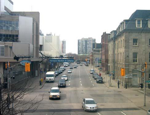
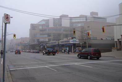
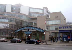
5 The Boulevard 9 Bay Street Copps Coliseum Philpot Church Coppley City owned parking garage James St. North Hamilton Public Library & Farmers Market City Centre 10 5
6


7 13 5 Visioning Principles Improve the condition, civic image, and the quality of the streetscape by improving all aspects of the streetscape and improving the pedestrian friendliness of the street. Enhance the street presence of the Farmers Market and Library. Improve the built-form character Provide temporary opportunities to close a portion of York Boulevard for public events and festivals. Recognize York Boulevard as an opportunity for place making 14 7


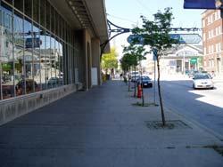
8 Pedestrian Friendly Streets Pedestrian friendly streets follow one simple rule - the pedestrian is a priority. Pedestrians are effectively separated from vehicular traffic. Through the use of wide sidewalks, on-street parking, and landscaping. Pedestrians can cross the street safely and easily. Crosswalks are designed to reduce pedestrian crossing distances, and clearly aligned with sidewalks. The streets are full of life. With storefronts and buildings that contain many openings creating visual interest and activity. On-street parking is available to support healthy retail. Focus on pedestrian amenity. with clear building entrances, well designed paving, street furniture and lighting make the street a place where people want to be


9 DESIGN 17 Design Wide Sidewalks. Urban Braille. What is Urban Braille? Made in Hamilton solution for aiding blind and visually impaired persons navigate our streets. 18 9
 wanted wide sidewalks.")


10 Competing interests: -Community Services (farmers market) wanted wide sidewalks. -Library wanted drop off/pick up. -Traffic wanted 5 lanes + efficient intersections -York is a truck route. 19 Design -New ideas about streetscapes Bringing 4 new ideas: Woonerf, Scramble Intersection, Back-in Head-out parking, and Flexible Streets


11 New ideas about streets The Woonerf Characterized by flush surface with paving demarcations of varying types, trees, bollards, and street furniture and reduced traffic signage. 21 New ideas about streetscapes Scramble intersections 'Scramble' crossing allows pedestrians to freely cross an intersections as vehicular traffic waits. Advantages: Reduces the number of crossings pedestrians make. Encourages pedestrians to cross at crossings. Creates a safe zone for crossing. Provides safe crossing for persons with disabilities


12 New ideas about streetscapes Back-in/ Head-out Parking Cars angle park backing in and heading out. Found on high-streets that might typically support parallel parking. Superior to conventional head-in - back out angle parking and parallel parking. Provides a safer environment for bicyclists since drivers are able to see them easier eliminates dooring. Easier than parallel parking, a common task on city streets (less accidents). More space efficient than parallel parking. Puts the trunk at the curb for occupant safety and convenience. Ideal for York Blvd. especially in front of the market. 23 New ideas about streetscapes Flexible Streets. These are streets that are designed to also function as public spaces for specific events such as markets, fairs, performance, parking, etc. This idea is especially relevant for York because of the Farmers market requirement to be open to the street

13 It was time for the Public Meeting What do you see is the primary design role for this street? 25 Street Sections Determine the Primary Goal


14 Streetscape Design Method Determine streetscape design direction given the defined transportation needs. What are the aesthetic and functional primary and secondary goals for York? Parking Cycling Sidewalks Primary Goal Secondary Goals Design 27 Street Sections: Parking 28 14
15 Street Sections: Parking 29 Street Sections: Cycling 30 15
16 Street Sections: Cycling 31 Street Sections: Sidewalks 32 16

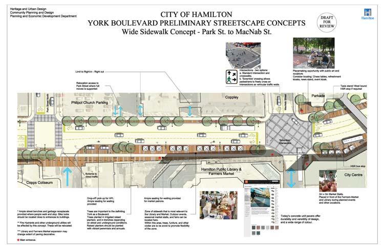
17 Street Sections: Sidewalks 33 Wide Sidewalk Concept Bay Street Philpot Church Coppley City owned parking garage James Street North City Centre Copps Coliseum Hamilton Public Library & Farmers Market 34 17


18 Wide Sidewalk Concept - Central Scramble intersection 2. Accesses conflict with streetscape relocate? 3. Library Drop off/ pick up 4. Market entrance 35 Wide Sidewalk 3D Model 36 18


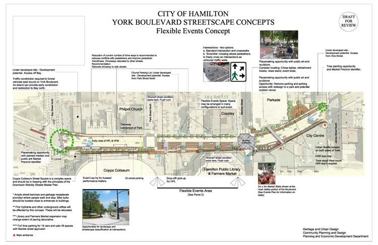
19 Flexible Parking Concept Bay Street Philpot Church Coppley City owned parking garage James Street North Copps Coliseum Hamilton Public Library & Farmers Market 37 Flexible Parking Concept - Central Angle parking (back-in/ head-out) 2. Library Drop off/ Pickup 3. Angle parking and stall area 4. Market entrance 5. Scramble intersection 6. Placemaking 38 19


20 Angle Parking - How to Park 39 Flexible Street How does it work? When a wide sidewalk is not needed such as winter or when the market is not on parking is permitted. A rolled curb and permanent bollards define parking. For special events angle parking is removed and stalls added. Parallel parking can remain providing much needed parking


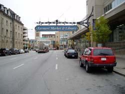
21 Flexible Parking Concept Non-event parking layout Event parking layout 41 York Boulevard From Bridge Street Scenes 42 21


22 Image showing festival layout Street Scenes 43 Street Scenes Current Sidewalk and parking condition 44 22


23 Street Scenes Sidewalk Design with Angle Parking 45 Shadow Study April 21 9am 12pm 4pm September 21 9am 12pm 4pm 46 23

24 The Changes 1. After further analysis we need 1 more lane to achieve a service level D. 2. No parking on the street Truck route, not enough capacity
25

26 51 What are the engineers afraid of? 52 26


27 The my approach 1. Gain initial acceptance of the principles and goals. 2. Recognize that critique is not something they are used to. 3. Ask them to explain things to you like they would to a member of the public. 4. Ask for the detailed work no hunches. 5. Get them to get involved in the design work assignment. 6. Get a hold of their standards. 53 Historic Pictures of York Street and Market 54 27
28 Thank You 55 28
FOCUS AREA 1 - Alberta Avenue Pocket Park 3 (121 Ave and 92 St)
") FOCUS AREA 1 - Alberta Avenue Pocket Park 3 (121 Ave and 92 St) New benches Plant evergreen trees Widen existing sidewalk from 1.5m to 1.8m Marked crosswalk 1.8m wide sidewalk Add pedestrian oriented lights
FOCUS AREA 1 - Alberta Avenue Pocket Park 3 (121 Ave and 92 St) New benches Plant evergreen trees Widen existing sidewalk from 1.5m to 1.8m Marked crosswalk 1.8m wide sidewalk Add pedestrian oriented lights
Bicycle and Pedestrian Advisory Committee (BPAC) November 21, 2013
 November 21, 2013") Bicycle and Pedestrian Advisory Committee (BPAC) November 21, 2013 OVERALL LAND USE CONCEPT Overall Broadway Valdez District: 95.5 acres (35.1 acres right-of ways + 60.4 acres developable land) Plan Subareas:
Bicycle and Pedestrian Advisory Committee (BPAC) November 21, 2013 OVERALL LAND USE CONCEPT Overall Broadway Valdez District: 95.5 acres (35.1 acres right-of ways + 60.4 acres developable land) Plan Subareas:
A CHANGING CITY. of Edmonton, it is essential that it reflects the long-term vision of the City.
 A CHANGING CITY By the year 2040, Edmonton will be home to more than 1 million people. To accommodate growth and support a healthy and compact city, we need a new approach to development/redevelopment
A Guide to Great Streets: The Basics. September 25, 2009
 A Guide to Great Streets: The Basics September 25, 2009 Streets are more than connectors, they are the city 2 Streets are the glue that hold a city together 3 Streets are the means in which a city is perceived
STONY PLAIN ROAD STREETSCAPE
 Jasper Place Revitalization Strategy: Vision The people involved in the Jasper Place Revitalization Strategy envision: Goal 1: Feeling safe in our community Create a community where feeling safe is common--where
Active Transportation Facility Glossary
 Active Transportation Facility Glossary This document defines different active transportation facilities and suggests appropriate corridor types. Click on a facility type to jump to its definition. Bike
Introduction. North 12 th Complete Street Project Overview
 Introduction On Wednesday, March 1, 2017, the City of Sacramento, in partnership with Sacramento Regional Transit District and the Sacramento Housing and Redevelopment Agency, hosted a community outreach
Report. Typical Sections. City of Middleton, WI
 Report Typical Sections City of Middleton, WI December 2006 Report for City of Middleton, Wisconsin Typical Sections repared by: Traffic Associates LLC and STRAND ASSOCIATES, INC. 910 West Wingra Drive
Obey Creek PEDESTRIAN CIRCULATION EAST WEST PARTNERS PEDESTRIAN CIRCULATION CREEK SIDE LANE SLIP STREET SCOTT MURRAY MAIN STREETS EAST/WEST
 THE VILLAGE AT PEDESTRIAN CIRCULATION MAIN STREETS NORTH/SOUTH MAIN STREETS EAST/WEST SLIP STREET CREEK SIDE LANE PEDESTRIAN CIRCULATION DESCRIPTION: Circulation through the downtown of is organized by
Tonight is for you. Learn everything you can. Share all your ideas.
 Strathcona Neighbourhood Renewal Draft Concept Design Tonight is for you. Learn everything you can. Share all your ideas. What is Neighbourhood Renewal? Creating a design with you for your neighbourhood.
PUBLIC REALM MASTER PLAN
 WESTSHORE BUSINESS DISTRICT PUBLIC REALM MASTER PLAN MASTER PLAN COMMITTEE MEETING MARCH 20, 2013 WESTSHORE BUSINESS DISTRCT PUBLIC REALM MASTER PLAN MACRO-SCALE CONCEPT: A PUBLIC REALM FRAMEWORK DEFINED
Better Market Street Project Update. Urban Forestry Council September 17, 2014
 Better Market Street Project Update Urban Forestry Council September 17, 2014 Project Area Limits Better Market Street Schedule Market Street City s busiest transit corridor Over 85 buses per hour 14 surface
Illustrated Principles of Good Planning
 Illustrated Principles of Good Planning The Miami 21 Zoning Code incorporates time-tested planning principles into the zoning regulations of our City. These are principles that make for better neighborhoods,
HUDSON, MA PUBLIC FEEDBACK SUMMARY Second Public Meeting October 26, :30pm Welcome and Rotary Trivia - 7:00-8:30pm Event
 MAIN STREET ROTARY HUDSON, MA PUBLIC FEEDBACK SUMMARY Second Public Meeting October 26, 2016-6:30pm Welcome and Rotary Trivia - 7:00-8:30pm Event The Second Public Meeting for the redesign of the Main
Complete Streets. Designing Streets for Everyone. Sarnia
 Complete Streets Designing Streets for Everyone Sarnia Complete Streets ~ Sarnia ~ 2018 Introduction Our City is made up of a network of streets that we use to go for a walk, cycle to work, drive to the
Chapter 3: Multi-Modal Circulation and Streetscapes
 CHAPTER 3: MULTI-MODAL CIRCULATION AND STREETSCAPES Chapter 3: Multi-Modal Circulation and Streetscapes Overview Streetscape improvements have already been completed for Depot Street between Main Avenue
Why invest in the 1 Street S.W. Corridor?
 Why invest in the 1 Street S.W. Corridor? This project is an investment in the Beltline Community and Calgary s economy. It is anticipated that The City s investment along this corridor will help with
Mainstreet Master Plan Land Use
 Mainstreet Master Plan 04 Land Use Top Recommendations Active Uses: Promote active ground-floor uses such as retail, restaurants, galleries and personal services with interactive storefronts for Mainstreet
Designing Complete Streets: What you need to know
 Designing Complete Streets: What you need to know Getting from this to this. Continuous sidewalk Buffer w/trees Bicycle lane Raised median Buildings close to the street Flexibility in design Design and
Miami Health District
 Miami Health District Streetscapes, Gateways, and Signage Basis of Design Report Study Miami Partnership Meeting July 21, 2008 Gannett Fleming EDAW The Corradino Group Sponsored by the Miami Partnership:
Completing the Vision
 Villas of Positano Completing the Vision North A1A Lane Reconfiguration N. Surf Rd. Redirection of Traffic Margaritaville Resort March 4, 2014 1 Completing The Vision Project Limits Hollywood Blvd. to
TRANSPORTATION NEEDS ASSESSMENT
 TRANSPORTATION NEEDS ASSESSMENT A travel demand analysis was carried out to determine the operational issues and the potential benefit that adding traffic capacity would have on the road network. All the
WHEREAS delivery trucks also pass through the Narrows, into the northern parking lot, to loading docks in the back of the building.
 CEDAR-ISLES-DEAN NEIGHBORHOOD ASSOCIATION ( CIDNA ) RESOLUTION OPPOSING A DRUG STORE DRIVE THRU, AND COMMENDING DORAN COMPANIES FOR PROPOSING MITIGATING AMENITIES INCLUDING NEW LANDSCAPING AND A DEDICATED
EXECUTIVE SUMMARY: TRANSIT-ORIENTED DEVELOPMENT IN SMITHS FALLS, ONTARIO; A COMPARISON BETWEEN TWO SITES
 EECUTIVE SUMMARY: TRANSIT-ORIENTED DEVELOPMENT IN SMITHS FALLS, ONTARIO; A COMPARISON BETWEEN TWO SITES Topic and Purpose In 2007, the Mayor of Ottawa s Task Force on Transportation suggested adding a
Southview Blvd & 3 rd Avenue Improvement Project. Public Open House December 4, to 7pm
 Southview Blvd & 3 rd Avenue Improvement Project Public Open House December 4, 2014 5 to 7pm Southview Blvd & 3 rd Avenue Public Information Meeting Agenda Presentation 5:30 to 6:15 pm Purpose of Project
WHITE STREET/ ENGLISH PLAZA STREETSCAPE IMPROVEMENT PROJECT
 WHITE STREET/ ENGLISH PLAZA STREETSCAPE IMPROVEMENT PROJECT 1 Project Goals 1 Improved Safety: Lighting, Multi-Modal Circulation, Emergency Access, Tripping Hazards; Stormwater 4 Environmental Performance:
Proposed. City of Grand Junction Complete Streets Policy. Exhibit 10
 Proposed City of Grand Junction Complete Streets Policy Exhibit 10 1 City of Grand Junction Complete Streets Policy Vision: The Complete Streets Vision is to develop a safe, efficient, and reliable travel
East Burke Transportation, Safety and Capacity Improvements
 East Burke Transportation, Safety and Capacity Improvements The purpose of this project is to increase mobility and improve safety for pedestrians, cyclists, and motor vehicles along VT Route 114 in the
COMPLETE STREETS PLANNER S PORTFOLIO
 COMPLETE STREETS PLANNER S PORTFOLIO ISSUE 3 APRIL 2016 PLANNER S PORTFOLIO COMPLETE STREETS 1 2 6 10 14 OVERVIEW MATURE NEIGHBORHOODS GROWING SUBURBS CENTRAL PLACES ACTIVITY CORRIDORS Planner s Portfolio
CLOSED. Highlights of the Final Concept Design:
 The final Concept Design is the result of many months of listening, learning, creating, balancing, and understanding different needs and viewpoints, as well as incorporating technical requirements and
5 Circulation & Parking
 5 Circulation & Parking Downtown Parking & Circulation Strategy. Downtown Wayne has a somewhat disconnected system of local public streets to connect downtown with the residential neighborhoods, and primary
El Centro Mobility Hub
 The El Centro drive shed comprises a major portion of the El Centro downtown area, which is well served by bus routes. The proposals intend to promote use of public transit through improvements and enhancements
PEDESTRIAN CIRCULATION & STREETSCAPE DESIGN
 CHAPTER 4 Chapter 4 Pedestrian Circulation & Trails PEDESTRIAN CIRCULATION & STREETSCAPE DESIGN In recent years, the City has constructed new sidewalks and enhanced existing ones in the downtown with brick
C C C
 C-012-001 Thank you for your support for the creation of new public space and nonmotorized access between downtown and the waterfront through the Overlook Walk, the East-West Connections, and the Promenade.
Community Meeting February 27, 2007 Dorchester Avenue Transportation & Streetscape Improvements Action Plan February 27, 2007
 Community Meeting Tonight s Agenda 6:00 Introductions South Boston/Dot Ave Improvement Study Background 6:15 Consultant Introductions Review of Scope and Schedule Review of Proposed Corridor Wide Guidelines
WELCOME. Purpose of the Open House. Update you on the project. Present a draft recommended plan. Receive your input
 WELCOME Purpose of the Open House The Town of Smiths Falls has initiated the Beckwith Street Redevelopment Plan that includes the preparation of a streetscape functional design for the renewal of Beckwith
Bicycle Facilities Planning
 Bicycle Facilities Planning Overview Types of Cyclists Purpose for Riding Types of Facilities Bike Lanes Bicycle Boulevards Cycle Tracks Intersections Signals Signing and Marking Discussion Types of Bicyclists
TRANSPORTATION COMMISSION Agenda Staff Report
 TRANSPORTATION COMMISSION Agenda Staff Report Agenda Item No. 5.a DATE: JULY 31, 2014 TO: FROM: SUBJECT: TRANSPORTATION COMMISSION COMMUNITY DEVELOPMENT DEPARTMENT - PLANNING DRAFT OLYMPIC CORRIDOR PREFERRED
Aurora Urban Street Standards For Transit Oriented Developments and Urban Centers
 Aurora Urban Street Standards For Transit Oriented Developments and Urban Centers I. Purpose These standards will be applied to create a safe, comfortable, pleasant and pedestrian-friendly multi-modal
TRAVEL PLAN: CENTRAL EUROPEAN UNIVERSITY CAMPUS REDEVELOPMENT PROJECT TRAVEL PLAN. Central European University Campus Redevelopment Project.
 TRAVEL PLAN Central European University Campus Redevelopment Project Page 1 Table of Contents Introduction... 3 Background... 7 Building Users... 7 Transportation in Community Consultation... 7 Summary
Newport City Thoroughfare Plan
 Newport City Thoroughfare Plan Summary This plan is intended to review and make recommendations for Newport City s thoroughfare network, in consideration of the full range of uses of the city s streets.
2014/2015 BIKE ROUTE PLAN 83 AVENUE PROTECTED BIKE LANE
 About the Project The City of Edmonton is planning a major bike route on the southside of Edmonton. The Strathcona Bike Route will connect the communities of Strathcona, Garneau and the University area,
Circulation Improvement Strategy. Chapter 5: Improvement Strategy. Cross Street Neighborhood Improvement Plan
 Circulation Improvement Strategy Chapter 5: Circulation Improvement Strategy Circulation Observations: Sidewalks are located throughout most of the neighborhood, although several sidewalks do not have
Footpath design. A guide to creating footpaths that are safe, comfortable, and easy to use
 Footpath design A guide to creating footpaths that are safe, comfortable, and easy to use November 2013 Contents Introduction / 1 Zoning system / 2 Width / 4 Height / 5 Surface / 5 Footpath elements /
Road Diets FDOT Process
 Florida Department of TRANSPORTATION Road Diets FDOT Process Humberto Castillero, PE, PTOE Roadway Design Office Purpose of Guide Develop a statewide lane elimination review process Balance state & local
Commerce Street Complete Street Project from Good Latimer Expressway to Exposition Avenue
 Commerce Street Complete Street Project from Good Latimer Expressway to Exposition Avenue T A N Y A B R O O K S A S S I S T A N T D I R E C T O R M O B I L I T Y P L A N N I N G M O B I L I T Y A N D S
City of Davis East Covell Corridor Plan
 Community Open House #2 January 22, 2014 6:00 8:00 p.m. Veterans Memorial Center, Club Room City of Davis Introduction The (ECCP) is a taking a comprehensive look at the existing transportation systems
Make Lincoln Highway an economically vibrant corridor that is safe, efficient, and beautiful for local residents and visitors.
 Lincoln Highway Streetscape Plan Stakeholder Workshop #2 Handout Contents Introduction and Project Vision Planning Principles Specific Recommendations including a Proposed Typical Roadway Section Renderings
Bikeway action plan. Bicycle Friendly Community Workshop March 5, 2007 Rochester, MN
 Bikeway action plan Summary The was held on March 5, 2007 at the Rochester Mayo Civic Center. The workshop was hosted by Rochester-Olmsted County Planning Department in collaboration with the League of
Vision: Traditional hamlet with an attractive business/pedestrian friendly main street connected to adjacent walkable neighborhoods
 N D. Focus Area II Vision: Traditional hamlet with an attractive business/pedestrian friendly main street connected to adjacent walkable neighborhoods Transit Road Focus Area II is located in the Hamlet
Columbia Pike Implementation Team (CPIT) Meeting
 Meeting") Columbia Pike Implementation Team (CPIT) Meeting November 30, 2010 Agenda Introductions / Purpose of Meeting Review of project goals Multimodal project: 10% street design between the curbs Discussion Multimodal
Columbia Pike Implementation Team (CPIT) Meeting November 30, 2010 Agenda Introductions / Purpose of Meeting Review of project goals Multimodal project: 10% street design between the curbs Discussion Multimodal
Ocean Park Boulevard Green Street Project Community Workshop
 Ocean Park Boulevard Green Street Project Community Workshop 2.2.10 Project Objectives Community Priority: reclaim OPB for public open space. Build upon LUCE principles; neighborhood enhancement, connectivity,
General Plan Circulation Element Update Scoping Meeting April 16, 2014 Santa Ana Senior Center, 424 W. 3rd Street, Santa Ana, CA 92701
 General Plan Circulation Element Update Scoping Meeting April 16, 2014 Santa Ana Senior Center, 424 W. 3rd Street, Santa Ana, CA 92701 Meeting Agenda 1. Purpose of Scoping Meeting 2. Project Overview 3.
George Street Concept Design
 George Street Concept Design City of Sydney with Gehl Architects This document sets out the design principles that will guide the detailed design of George Street. It outlines strategies and concepts for
Blackfalds Downtown. Architectural Guidelines: Streetscape
 Blackfalds Downtown Architectural Guidelines: Streetscape Streetscape INTRODUCTION A variety of street furniture has been chosen for locations within the Town of Blackfalds Downtown and highway commercial
RZC Appendix 8A Marymoor Subarea Street Requirements
 RZC Appendix 8A Marymoor Subarea Street Requirements For additional design details for Marymoor Subarea infrastructure, refer to the 2017 Marymoor Subarea Infrastructure Planning Report. STREET REQUIREMENTS
CONNECTIVITY PLAN. Adopted December 5, 2017 City of Virginia Beach
 CONNECTIVITY PLAN Adopted December 5, 2017 City of Virginia Beach CONTENTS 1.0 Background & Purpose... 2 2.0 Existing Inventory & Analysis... 3 ViBe District Existing Walking Conditions... 4 3.0 ViBe District
Enhancing Downtown
 Enhancing Downtown 2014-2015 Process Masterplan reviewed TIF scope, fund availability, and timing Conceptual cost estimate stage things may change with full engineering Sequencing Coordination with businesses
WalkShop. Highland Creek Village
 On June 5, 2014, 15 people participated in a for the Transportation Master Plan. The purpose of the was to receive feedback from a diverse range of local stakeholders and document existing transportation
Shared Space/ Shared Zone in Private Estates and the Public Domain - what it means for pedestrians?
 Walk21-2014 Shared Space/ Shared Zone in Private Estates and the Public Domain - what it means for pedestrians? Wayne Johnson Wayne.johnson@gta.com.au Brigette Humphrey-Robinson Dick van den Dool Outline
CITY OF SLO SEEKS INPUT ON PREFERRED ALTERNATIVE FOR BROAD STREET BICYCLE BOULEVARD PROJECT
 City of San Luis Obispo, News Release DATE: August 1, 2017 RELEASE: Immediate CONTACT: Luke Schwartz (805) 781-7190 Transportation Planner-Engineer, Public Works CITY OF SLO SEEKS INPUT ON PREFERRED ALTERNATIVE
* With exceptions for topography or special circumstances.
 Block Length Limits* Salem, OR 600 ft (180 m) Portland, OR Davidson, NC Raleigh, NC Fort Collins, CO Boulder, CO 530 ft 600 ft 1,500 ft Max block size (7-12 acres) 350 ft (by practice) * With exceptions
to the Public Information Centre for the Downtown Traffic Study
 to the Public Information Centre for the Downtown Traffic Study City of Sault Ste. Marie July 25, 2018 Purpose of Study Determine if changes to one-way corridors can enhance downtown s character and spaces
Steps to Conducting a Complete Streets Assessment
 Steps to Conducting a Complete Streets Assessment Familiarize yourself with Complete Streets Read through the Complete Streets Assessment Guidelines. This will give you an idea of what Complete Streets
Highland Creek Village Transportation Master Plan
 Highland Creek Village Transportation Master Plan Information Booklet On-Street Parking Discussion November 9, 04 Highland Creek Village Transportation Master Plan www.toronto.ca/hcvtransportation Old
CURBSIDE ACTIVITY DESIGN
 5 CURBSIDE ACTIVITY DESIGN This chapter provides design guidance for separated bike lanes adjacent to curbside activities including parking, loading and bus stops. Typical configurations are presented
THE ALAMEDA CONCEPT DESIGN COMMUNITY MEETING 3. A Plan for The Beautiful Way JANUARY 28, 2010
 CONCEPT DESIGN COMMUNITY MEETING 3 JANUARY 28, 2010 AGENDA INTRODUCTION COMMUNITY INPUT ROADWAY STUDIES STREETSCAPE DESIGN STATIONS DISCUSSION SUMMARY AND DISCUSSION NEXT STEPS CLOSE INTRODUCTION SCHEDULE
UDC Street Cross Sections
 UDC Street Cross Sections Local Street - Downtown Local Street Mountable Curb Local Street Vertical Curb Alley Major Arterial Minor Arterial Residential Lane Residential Collector Residential Collector
What Is a Complete Street?
 Session 5 Charleen Zimmer, AICP, Zan Associates May 5-7, 2010 What Is a Complete Street? May 2010 5-1 Not a Complete Street More of a Complete Street May 2010 5-2 Benefits of Complete Streets Safety for
WORKSHOP 2 SUMMARY OVERVIEW GENERAL COMMENTS. Walking and Biking. Greening & Stormwater. Transportation & Parking. Lighting, Art and Identity
 WORKSHOP 2 SUMMARY OVERVIEW On May 9, 2016, 55 people came to the second public meeting for the Lower Haight Public Realm Plan. Roughly 34 of attendees were neighborhood residents. The open house was a
MARTIN LUTHER KING JR. WAY
 OCTOBER 2011 40 Vision and Goals The Martin Luther King, Jr. Way Illustrative Master Plan that follows has been developed through a process of community involvement. It expresses a long term vision for
Plant City Walk-Bike Plan
 Plant City Walk-Bike Plan Plant City Commute Mode Share 2.2% 1.4% 2.9% Drove alone 10.2% Carpooled Public transportation (0.1%) Walked Used a Bike (0.4%) 82.9% Taxicab, motorcycle, or other means Worked
STREETSCAPE CONCEPTS
 STREETSCAPE S CARGO WAY CARGO WAY CYCLE TRACK Streetscape Concepts JENNINGS ST Illustrative Plan EVANS AVE PG&E BAY TRAIL HERON S HEAD PARK The recommended improvements build off the planned improvements
APPENDIX A: Complete Streets Checklist DRAFT NOVEMBER 2016
 APPENDIX A: Complete Streets Checklist DRAFT NOVEMBER 2016 Complete Streets Checklist MetroPlan Orlando s Complete Streets Checklist is an internal planning tool for staff to further implementation of
Broad Street Bicycle Boulevard Design Guidelines
 Broad Street Bicycle Boulevard Design Guidelines Building from the strategies introduced in the 2013 Bicycle Transportation Plan and community input received thus far, City Transportation Staff have identified
Welcome. Welcome to the second open house on the Downtown Transportation Study.
 Welcome 1 Welcome to the second open house on the Downtown Transportation Study. The purpose of this meeting is to: Recap the study objectives Summarize feedback to date Present information on the alternatives
PEDESTRIAN ACCOMMODATIONS DPS 201 AT ROUNDABOUTS
 PEDESTRIAN ACCOMMODATIONS DPS 201 AT ROUNDABOUTS WHY THEY WORK FOR PEDESTRIANS IF DESIGNED CORRECTLY Separated sidewalks direct peds to crosswalks Splitter island Slow speed exit Truck apron Crosswalk
Streetscape: Core Shopping District
 Streetscape: Core Shopping District DRAFT DRAFT DRAFT May 00 Core Shopping District: Phase Blue Island s Core Shopping District is located along Western Avenue, between Grove and Union Streets. Streetscape
Community Task Force March 14, 2018
 Community Task Force March 14, 2018 Welcome and Introductions Project Partners Regional Transportation District (RTD) City of Aurora Colorado Department of Transportation (CDOT) Denver Regional Council
Brooklyn Boulevard (County Road 152) Reconstruction Project Phase I. OPEN HOUSE June 20, 2017
 Reconstruction Project Phase I. OPEN HOUSE June 20, 2017") Brooklyn Boulevard (County Road 152) Reconstruction Project Phase I OPEN HOUSE June 20, 2017 Brooklyn Boulevard (County Road 152) Phase I Project Partners Project Lead Other Project Partners include Brooklyn
Brooklyn Boulevard (County Road 152) Reconstruction Project Phase I OPEN HOUSE June 20, 2017 Brooklyn Boulevard (County Road 152) Phase I Project Partners Project Lead Other Project Partners include Brooklyn
Alternative Traffic Calming Methods
 Alternative Traffic Calming Methods In-street Pedestrian Crossing Sign Cost: approximately $300 per sign not including the installation cost Advantages of in-street pedestrian crossing signs 1. Typically
Reconnecting Communities ACTION PLAN FOR LOGAN CIRCLE
 Reconnecting Communities ACTION PLAN FOR LOGAN CIRCLE Project for Public Spaces, Inc. May 2003 Reconnecting Communities ACTION PLAN FOR LOGAN CIRCLE VINE STREET EXPRESSWAY, PHILADELPHIA, PA Prepared by:
Figure 4-10: Pedestrian Improvements Types of Potential Station Area Improvements - Place-Making Improvements
 INCORPORATE FEATURE PAVIN IN CROSSWALK AND INTERSECTION FIELDS Identifies high-priority pedestrian areas and create a station identity through colorful and interesting patterns ADD CURB EXTENSIONS Extending
5. Automobile Circulation, Wayfinding and Signage
 5. Automobile Circulation, Wayfinding and Signage Policy: The City Center should have a balanced, safe, and interconnected circulation system that provides expanded travel opportunities for transit, pedestrian,
Small Town & Rural Multimodal Networks
 Small Town & Rural Multimodal Networks Fred Young, PLA Andrea Clinkscales, AICP, PMP Alta Planning + Design Funding Partners Project Team Existing Design Guidance AASHTO Flexibility Guide 2004 AASHTO Bike
Boston Post Road Design Feasibility Study
 Boston Post Road Design Feasibility Study Prepared for the City of Rye Final Report July 18, 2007 Prepared by: Buckhurst Fish & Jacquemart (BFJ) 115 Fifth Avenue New York, NY 10003 www.bfjplanning.com
El Camino Real Specific Plan. TAC/CAC Meeting #2 Aug 1, 2018
 El Camino Real Specific Plan TAC/CAC Meeting #2 Aug 1, 2018 Land Use Alternatives Goals and Tradeoffs Parks & open space Housing Retail & services Civic spaces Parking Community gathering spaces 3 Alternatives
Toronto Complete Streets Guidelines
 Toronto Complete Streets Guidelines 18 20 2.1 Understanding Street Type 22 2.2 Use of Overlays 23 2.3 Toronto Understanding the roles and relationships of a street with its surrounding context is a critical
Appendix A: Crosswalk Policy
 Appendix A: Crosswalk Policy Appendix A: Crosswalk Policy Introduction This citywide Crosswalk Policy is aimed at improving pedestrian safety and enhancing pedestrian mobility by providing a framework
Introduction. Who is WILMAPCO. Why are walkable communities important
 Walkable Community Workshops Round 1 April 2005 SPONSORED BY WILMAPCO AND CCOBH CITY OF NEW CASTLE EDGEMOOR GARDENS CIVIC ASSOCIATION WITH FUNDING BY DELAWARE DEPARTMENT OF TRANSPORTATION AND THE DELAWARE
14 TH STREET TRANSPORTATION & STREETSCAPE DESIGN STUDY PLAN B PLAN B TRANSPORTATION & STREETSCAPE RECOMMENDATIONS
 14 TH STREET TRANSPORTATION & STREETSCAPE DESIGN STUDY PLAN B PLAN B TRANSPORTATION & STREETSCAPE RECOMMENDATIONS 141 Symbols Recommendations - Southern End of 14th Street Study Area Streetscape Each icon
Working Group Meeting
 Working Group Meeting February 6, 2018 Parks and Natural Resources Operations Building Transportation Analysis Draft Policy Framework Agenda 7:05 pm Welcome 7:10 pm Follow-up from Previous Meetings Schedule
TRAFFIC CALMING TOOLBOX. For the residents of the City of Decatur, Georgia
 TRAFFIC CALMING TOOLBOX For the residents of the City of Decatur, Georgia 2 City of Decatur Traffic Calming Toolbox Public Works Department 2635 Talley Street Decatur, GA 30030 404.377.5571 3 Welcome to
CURRENT ORIGINAL REFERENCE SECTIONS. (Typical Section) (Typical Section) The Parade Island Bay : Concept Option Summary Sheets.
 (Typical Section) The Parade Island Bay : Concept Option Summary Sheets.") ORIGINAL (Typical Section) CURRENT (Typical Section) 3,900 3,000 2,000 1,500 3,100 1,600 3,100 1,500 2,000 2,500 3,900 3,000 1,800 600 2,000 3,000 3,000 2,000 600 1,800 2,500 Existing Planting Traffic
ORIGINAL (Typical Section) CURRENT (Typical Section) 3,900 3,000 2,000 1,500 3,100 1,600 3,100 1,500 2,000 2,500 3,900 3,000 1,800 600 2,000 3,000 3,000 2,000 600 1,800 2,500 Existing Planting Traffic
City of Vallejo Traffic Calming Toolbox
 City of Vallejo Traffic Calming Toolbox June 1, 2013 Final Table of Contents Introduction... 1 Non-Physical Devices... 3 High-Visibility Crosswalk... 3 In Pavement Lighted Crosswalk... 4 Rapid Flashing
Centennial Neighbourhoods Transportation Management Plan Summary of Phase 1 Consultation. Overview of Issues
 1 Centennial Neighbourhoods Transportation Management Plan Summary of Phase 1 Consultation The Centennial Neighbourhoods Transportation Management Plan (CNTMP) is being undertaken to support the Secondary
Raymond Avenue: Rightsizing Improved Safety and Pedestrian Experience
 Page 1 of 5 Work With Us Free Newsletter Stay Connected Home About Services Training Projects Placemaking Blog Resources Reference Store Great Public Spaces Image Collection Raymond Avenue: Rightsizing
Item to be Addressed Checklist Consideration YES NO N/A Required Description Complete Streets Guidelines
 Passaic County Complete Streets Checklist - Concept Development Project Name Item to be Addressed Checklist Consideration YES NO N/A Required Description Complete Streets Guidelines Existing Plans Have
REGIONAL BICYCLE AND PEDESTRIAN DESIGN GUIDELINES
 REGIONAL BICYCLE AND PEDESTRIAN DESIGN GUIDELINES November 16, 2011 Deb Humphreys North Central Texas Council of Governments Bicycle and Pedestrian Advisory Committee Snapshot of the Guide 1. Introduction
Pattullo Bridge Replacement Project Community Connections Phase 2 Consultation. Appendix 3: Open House Display Boards
 Replacement Project Community Connections Phase 2 Consultation Appendix 3: Open House Display Boards November 2016 Welcome! Welcome to the Replacement Project Public Open House We Want to Hear from You