Pedestrian Simulation Modeling World Trade Center Memorial
|
|
|
- Frederick Kennedy
- 6 years ago
- Views:
Transcription
1 Pedestrian Simulation Modeling World Trade Center Memorial NYMTC Brown Bag Lunch June 20, 2007 Suany Chough World Trade Center Memorial Foundation Michael F. Monteleone, AICP, PP The Louis Berger Group, Inc.
2 Why Use Pedestrian Simulation Software? Evaluate Complex Pedestrian Environments Analyze to scale in two-dimensions in real time Accurately Depict Pedestrian Movement Model Multiple Pedestrian Behavior Add Pedestrian Factor to Design Process Can Design Accommodate Pedestrians? 2
3 Notable Pedestrian Analysis Tools Analytical HCS Fruin Methodology (Spreadsheets) Simulation STEPS Myriad (Crowd Dynamics) Legion IATA 3
4 What is LEGION Software? Dynamic Simulation Real-time 2-D Non-grid based Smart Based on Empirical Data 4

5 Legend Blue Dots = Commuters entering the Station Red Dots = Commuters leaving the Station Yellow Dots = Tourists entering/leaving the station 5
6 What do the Dots Represent? 2-D People with Individual Profiles Age Size Walking Speed Itinerary 6
7 What are the Profiles Based Upon? Data Collected from: Europe Far East North America Pedestrian profile categories include: Commuters Tourists 7
8 Model Development Steps CAD Base Map Site Design Operational Assumptions Pedestrian Origin/Destination Matrix Coding Model Output Recommendations 8


9 How does the Program work? THE MODEL BUILDER Defines the environment THE ANALYSER Plays the results THE SIMULATOR Compiles the data and performs analysis 9
10 The World Trade Center Memorial MUSEUM PAVILION LIBERTY STREET SOUTH POOL GREENWICH STREET GLADE NORTH POOL FULTON STREET WEST STREET 10

11 Memorial Plaza Pedestrian Simulation Modeling 11
12 Need for Pedestrian Simulation Physical design queuing, ticketing, landscaping Visitor experience Operational efficiency Security and safety concerns A customized, fine grained analysis 12
13 Client Process Pedestrian Simulation Modeling Joint effort with LMDC, began August 2005 Funded through project design budget Berger chosen for leadership in field, experience with site, and partnership with Legion Development of assumptions was educational Iterative process responded to design changes Results suggest the need for a district-wide, multi-modal study 13
14 Memorial Quadrant
15 Key Model Analyses Plaza Level Queuing Security Screening Vertical Pedestrian Circulation Streetscape Activity Areas Delay Points Bus Operations 15
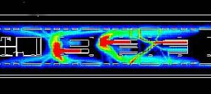
16 Pedestrian Model Outputs AVIs (Video): Pedestrian Movements Desire Lines Maps: Density maps Space Utilization Graphs: Journey times Waiting times/delay Densities experienced Satisfaction experienced 16
17 Simulation to be provided World Trade Center Memorial Site
18 Simulation to be provided World Trade Center Memorial Site: Northeast Quadrant
19 Simulation to be provided World Trade Center Memorial Site: Southeast Quadrant
20 Simulation to be provided World Trade Center Memorial Site: Southwest Quadrant
21 Simulation to be provided World Trade Center Memorial Site: Northwest Quadrant

22 Additional Model Outputs: MAPS Graphs 22
23 Map to be provided Cumulative Mean Density (LOS) Map
24 Map to be provided Space Utilization Map
25 Map to be provided Discomfort Map
26 Study Results Design Operations Validation 26
27 Results - Design Programming Paths Signage Portal Locations Building size 27
28 Results - Operations Queuing Security Pools Benches Buses Viewing Areas 28
29 Results - Validation Congestion Space Utilization Discomfort 29
30 Questions???? 30
Pedestrian Simulation Modeling World Trade Center Memorial
 Pedestrian Simulation Modeling World Trade Center Memorial CSS National Dialogue Tuesday, March 16, 2010 Busch Campus Center, Rutgers University Piscataway, New Jersey Michael F. Monteleone, AICP, PP The
Nørreport Pedestrian Simulation Technology Grontmij Carl Bro and Legion real-time 3D simulation model of the Station General Overview and Conclusions
 Nørreport Pedestrian Simulation Technology Grontmij Carl Bro and Legion real-time 3D simulation model of the Station General Overview and Conclusions Contents 1. Introduction to Pedestrian Simulation from
Enhancing Transit Facility Design
 Enhancing Transit Facility Design Steven P. Scalici 1, P.E., Patrick J. O Mara 2, P.E., and Raymond Dominguez 3 1, 2, 3 STV Inc., 225 Park Avenue South, NY, NY 10003; (212) 777-4400; FAX (212) 529-5237;
CITY OF COCOA BEACH 2025 COMPREHENSIVE PLAN. Section VIII Mobility Element Goals, Objectives, and Policies
 CITY OF COCOA BEACH 2025 COMPREHENSIVE PLAN Section VIII Mobility Element Goals, Objectives, and Policies Adopted August 6, 2015 by Ordinance No. 1591 VIII MOBILITY ELEMENT Table of Contents Page Number
Effective Pedestrian Planning. Sam Chow, Director of Transport Consulting 7 May 2013
 Effective Pedestrian Planning Sam Chow, Director of Transport Consulting 7 May 2013 Outline Introduction effective planning Arup experience Traffic Study for Admiralty interchange Way-finding 3D vital
PREPARED TESTIMONY OF NICK CONNOR. Q. Please state your name, professional position, and business address.
 Application 06-12-005 et al. Exhibit Date: August, 2008 PREPARED TESTIMONY OF NICK CONNOR Q. Please state your name, professional position, and business address. A. My name is Nick Connor. I presently
HIGHWAY CAPACITY MANUAL
 HISTORY OF THE HIGHWAY CAPACITY MANUAL TexITE - Houston Chapter November 10, 2010 Michael Y. Ereti City of Houston Department of Public Works & Engineering THE NEW GUY (Michael Ereti) Consultant (10 years)
Simulating Street-Running LRT Terminus Station Options in Dense Urban Environments Shaumik Pal, Rajat Parashar and Michael Meyer
 Simulating Street-Running LRT Terminus Station Options in Dense Urban Environments Shaumik Pal, Rajat Parashar and Michael Meyer Abstract The Exposition Corridor transit project is a light rail project
Introduction Roundabouts are an increasingly popular alternative to traffic signals for intersection control in the United States. Roundabouts have a
 HIGH-CAPACITY ROUNDABOUT INTERSECTION ANALYSIS: GOING AROUND IN CIRCLES David Stanek, PE and Ronald T. Milam, AICP Abstract. Roundabouts have become increasingly popular in recent years as an innovative
US 41 COMPLETE STREETS CORRIDOR PLANNING STUDY from University Parkway to Whitfield Avenue
 41 US 41 COMPLETE STREETS CORRIDOR PLANNING STUDY from University Parkway to Whitfield Avenue EXECUTIVE SUMMARY DRAFT FEBRUARY 2019 Project Overview The US 41 Complete Streets Corridor Planning Study,
Integrated Corridor Approach to Urban Transport. O.P. Agarwal World Bank Presentation at CODATU XV Addis Ababa, 25 th October 2012
 Integrated Corridor Approach to Urban Transport O.P. Agarwal World Bank Presentation at CODATU XV Addis Ababa, 25 th October 2012 What is the Integrated Corridor Approach for Urban Transport Public? Why
A COMPREHENSIVE APPROACH TO TRANSPORTATION AT SUNTRUST PARK AND THE BATTERY ATLANTA
 A COMPREHENSIVE APPROACH TO TRANSPORTATION AT SUNTRUST PARK AND THE BATTERY ATLANTA Overview The Atlanta Braves strategically selected the location for SunTrust Park to provide an environment rich in transportation
Balancing Operation & Safety for Motorized and Non-Motorized Traffic
 Balancing Operation & Safety for Motorized and Non-Motorized Traffic Brian Willham, PE, PTOE Iowa Director - MOVITE June 30, 2014 Learning Objectives: When & Why should we measure the performance of complete
James Williams Middle School 915 Acacia Lane
 James Williams Middle School 915 Acacia Lane Grades Served: 6 th -8 th Student Geography According to an address analysis of students, 36.7% of students attending JWMS live within 2 miles of school (see
Vision: Traditional hamlet with an attractive business/pedestrian friendly main street connected to adjacent walkable neighborhoods
 N D. Focus Area II Vision: Traditional hamlet with an attractive business/pedestrian friendly main street connected to adjacent walkable neighborhoods Transit Road Focus Area II is located in the Hamlet
Thursday 18 th January Cambridgeshire Travel Survey Presentation to the Greater Cambridge Partnership Joint Assembly
 Thursday 18 th January 2018 Cambridgeshire Travel Survey Presentation to the Greater Cambridge Partnership Joint Assembly Contents 1. Study Background 2. Methodology 3. Key Findings An opportunity for
Subject: Solberg Avenue / I-229 Grade Separation: Traffic Analysis
 MEMORANDUM Transportation Bill Troe, AICP Jason Carbee, AICP 12120 Shamrock Plaza Suite 300 Omaha, NE 68154 (402) 334-8181 (402) 334-1984 (Fax) To: Project File Date: Subject: Solberg Avenue / I-229 Grade
Transportation Impact Study for Abington Terrace
 Transportation Impact Study for Abington Terrace Abington Township, Montgomery County, PA Sandy A. Koza, P.E., PTOE PA PE License Number PE059911 Prepared by McMahon Associates, Inc. 425 Commerce Drive,
PLAN FOR ARENA OPERATIONS. City Council May 24, 2016
 PLAN FOR ARENA OPERATIONS City Council May 24, 2016 PROJECT OVERVIEW GOLDEN 1 CENTER OPERATIONS PROJECT SITE PLAN PROJECT SCHEDULE GOLDEN 1 CENTER OPERATIONS GOLDEN 1 CENTER AND DOCO SCHEDULE FULL ENCLOSURE
Roundabout Design 101: Roundabout Capacity Issues
 Design 101: Capacity Issues Part 2 March 7, 2012 Presentation Outline Part 2 Geometry and Capacity Choosing a Capacity Analysis Method Modeling differences Capacity Delay Limitations Variation / Uncertainty
Pedestrian Level of Service at Intersections in Bhopal City
 Pedestrian Level of Service at Intersections in Bhopal City 1 Rakesh Wahane 1 M.E. Student 1 Department of Civil Engineering 1 Samrat Ashok Technological Institute Vidisha MP 464001 Abstract - This study
TRAFFIC STUDY GUIDELINES Clarksville Street Department
 TRAFFIC STUDY GUIDELINES Clarksville Street Department 9/1/2009 Introduction Traffic studies are used to help the city determine potential impacts to the operation of the surrounding roadway network. Two
Mobility studies Dynamic pedestrian simulations
 concevoir maîtriser Mobility studies Dynamic pedestrian simulations Transports et leurs infrastructures Construction et urbanisation Energie et industries Développement durable www.setec.fr/en Summary
List of Display Boards
 List of Display Boards Welcome Introduction Municipal Class Environmental Assessment (EA) Process Need and Justification for an Interchange Alternatives for Evaluation Vertical and Horizontal Alignments
BETHEL ROAD AND SEDGWICK ROAD CORRIDOR STUDY
 DRAFT PLAN City Council Meeting August 14, 2017 STUDY AREA Sedgwick Corridor State Route 160, principal arterial with Class 3 access management designation, commuter and freight route, connection to SR
Modelling Pedestrian Circulation in Rail Transit Stations Using Micro-Simulation
 Modelling Pedestrian Circulation in Rail Transit Stations Using Micro-Simulation ATRF 2009 Venue: Auckland, New Zealand Date: September 30, 2009 Galiza*/Kim**/Ferreira*/Laufer** *University of Queensland
PennDOT Bicycle and Pedestrian Initiatives. Jonathan Heilman Roy Gothie Angela Watson
 PennDOT Bicycle and Pedestrian Initiatives Jonathan Heilman Roy Gothie Angela Watson Bicycle and Pedestrian Policy Study Policy Study Purpose Strengthen existing bike ped policy Recognize limited funding
TRANSPORTATION ANALYSIS REPORT US Route 6 Huron, Erie County, Ohio
 TRANSPORTATION ANALYSIS REPORT US Route 6 Huron, Erie County, Ohio December 12, 2012 Prepared for: The City of Huron 417 Main Huron, OH 44839 Providing Practical Experience Technical Excellence and Client
The Application of Pedestrian Microscopic Simulation Technology in Researching the Influenced Realm around Urban Rail Transit Station
 Journal of Traffic and Transportation Engineering 4 (2016) 242-246 doi: 10.17265/2328-2142/2016.05.002 D DAVID PUBLISHING The Application of Pedestrian Microscopic Simulation Technology in Researching
Integrated Pedestrian Simulation in VISSIM
 Integrated Pedestrian Simulation in VISSIM PTV worldwide MUGS Conference October 30-31, 2008 Wellington Founded > 1979 30 years fast approaching Employees > Approximately 800 persons in the PTV Group worldwide
Vallecito Elementary School. Travel Plan
 Vallecito Elementary School Travel Plan TABLE OF CONTENTS 1. PURPOSE... 1 1.1. SR2S PLANNING, IMPLEMENTATION AND MONITORING... 1 1.2. MARIN COUNTY MEASURE A... 1 2. VALLECITO ELEMENTARY SCHOOL PROFILE...
WHEREAS delivery trucks also pass through the Narrows, into the northern parking lot, to loading docks in the back of the building.
 CEDAR-ISLES-DEAN NEIGHBORHOOD ASSOCIATION ( CIDNA ) RESOLUTION OPPOSING A DRUG STORE DRIVE THRU, AND COMMENDING DORAN COMPANIES FOR PROPOSING MITIGATING AMENITIES INCLUDING NEW LANDSCAPING AND A DEDICATED
Multimodal Analysis in the 2010 Highway Capacity Manual
 Multimodal Analysis in the 2010 Highway Capacity Manual It s not just cars anymore! Jamie Parks, AICP HCAT Conference May 9-10, 2011 Multimodal LOS in the 2010 HCM History and background Overview of methods
Moving Towards Complete Streets MMLOS Applications
 Moving Towards Complete Streets MMLOS Applications Transportation Education Series May 18 th, 2012 It s not just for cars! Presentation Overview The Complete Streets Movement What is Multi-Modal Level
NO BUILD TRAFFIC OPERATIONS
 3. 23 NO BUILD TRAFFIC OPERATIONS This section addresses the operations of the transportation system and details how it would be expected to function under year 23 No Build conditions with the projected
METROPOLITAN TRANSPORTATION PLAN OUTREACH: INTERACTIVE MAP SUMMARY REPORT- 10/03/14
 METROPOLITAN TRANSPORTATION PLAN OUTREACH: INTERACTIVE MAP SUMMARY REPORT- 10/03/14 INTRODUCTION This document summarizes the results of the online interactive mapping exercise implemented by MIG for the
IV. Environmental Impact Analysis B.3 Pedestrian Circulation and Bicycle and Pedestrian Safety
 IV. Environmental Impact Analysis B.3 Pedestrian Circulation and Bicycle and Pedestrian Safety 1. Introduction This section analyzes the potential impacts of the Project on pedestrian circulation and bicycle
Niantic Center Elementary School
 Niantic Elementary School is located in the Northwest corner of the intersection of West Main Street and East Pattagansett Road, as so noted on the Facility Location Map. location Overview: The site is
How To Encourage More Efficient Transportation in Brazilian Cities
 How To Encourage More Efficient Transportation in Brazilian Cities Todd Litman Victoria Transport Policy Institute Presented Seminar on Discouraging The Use Of Cars São Paulo, Brazil 3 September 2013 Creating
METHODOLOGY. Signalized Intersection Average Control Delay (sec/veh)
") Chapter 5 Traffic Analysis 5.1 SUMMARY US /West 6 th Street assumes a unique role in the Lawrence Douglas County transportation system. This principal arterial street currently conveys commuter traffic
Chapter 5 Traffic Analysis 5.1 SUMMARY US /West 6 th Street assumes a unique role in the Lawrence Douglas County transportation system. This principal arterial street currently conveys commuter traffic
unsignalized signalized isolated coordinated Intersections roundabouts Highway Capacity Manual level of service control delay
 Whether unsignalized or signalized, isolated or coordinated, you can use TransModeler to simulate intersections with greater detail and accuracy than any other microsimulation software. TransModeler allows
#19 MONITORING AND PREDICTING PEDESTRIAN BEHAVIOR USING TRAFFIC CAMERAS
 #19 MONITORING AND PREDICTING PEDESTRIAN BEHAVIOR USING TRAFFIC CAMERAS Final Research Report Luis E. Navarro-Serment, Ph.D. The Robotics Institute Carnegie Mellon University November 25, 2018. Disclaimer
DOI /HORIZONS.B P23 UDC : (497.11) PEDESTRIAN CROSSING BEHAVIOUR AT UNSIGNALIZED CROSSINGS 1
 PEDESTRIAN CROSSING BEHAVIOUR AT UNSIGNALIZED CROSSINGS 1") DOI 10.20544/HORIZONS.B.03.1.16.P23 UDC 656.142.054:159.922(497.11) PEDESTRIAN CROSSING BEHAVIOUR AT UNSIGNALIZED CROSSINGS 1 JelenaMitrovićSimić 1, Valentina Basarić, VukBogdanović Department of Traffic
DOI 10.20544/HORIZONS.B.03.1.16.P23 UDC 656.142.054:159.922(497.11) PEDESTRIAN CROSSING BEHAVIOUR AT UNSIGNALIZED CROSSINGS 1 JelenaMitrovićSimić 1, Valentina Basarić, VukBogdanović Department of Traffic
Planning Regionally With Transit
 Planning Regionally With Transit Nathan Coats Director of Operations CTAA Expo 2015 Tampa Began 1992. Serves eastern Cache County to Preston, ID. Population- 115,000 34 bus fleet, 26 fixed route buses;
Highway 111 Corridor Study
 Highway 111 Corridor Study June, 2009 LINCOLN CO. HWY 111 CORRIDOR STUDY Draft Study Tea, South Dakota Prepared for City of Tea Sioux Falls Metropolitan Planning Organization Prepared by HDR Engineering,
INCREASING SCHOOL-YEAR ROAD SAFETY: PROVEN STRATEGIES YOU CAN USE NOW
 INCREASING SCHOOL-YEAR ROAD SAFETY: PROVEN STRATEGIES YOU CAN USE NOW Presenter Cam Reed Territory Manager All Traffic Solutions ABOUT CAM REED Cam spent 15 years in law enforcement, most of those years
Addendum to Mitigated Negative Declaration
 Addendum Date: Case No.: 2014.1499E Project Title: (MDSP) - Mission Valencia Green Gateway Streetscape Project Original: 2008.1075, MDSP Mitigated Negative Declaration Project Sponsor: Charlie Ream, San
TRAFFIC IMPACT ANALYSIS
 TRAFFIC IMPACT ANALYSIS FOR THE CHAMPAIGN UNIT#4 SCHOOL DISTRICT PROPOSED HIGH SCHOOL (SPALDING PARK SITE) IN THE CITY OF CHAMPAIGN Final Report Champaign Urbana Urbanized Area Transportation Study 6/24/2014
DRAFT Davidson Elementary School Expansion Transportation Impact Analysis
 DRAFT Davidson Elementary School Expansion Transportation Impact Analysis Prepared for: Town of Davidson 216 S. Main Street Davidson, NC 28036 Prepared by: Stantec Consulting Services Inc. 2127 Ayrsley
Make Lincoln Highway an economically vibrant corridor that is safe, efficient, and beautiful for local residents and visitors.
 Lincoln Highway Streetscape Plan Stakeholder Workshop #2 Handout Contents Introduction and Project Vision Planning Principles Specific Recommendations including a Proposed Typical Roadway Section Renderings
Gdynia s bicycle model
 Gdynia s bicycle model Problems related to cycling network and demand modelling Michał Miszewski, city of Gdynia Development of tool for transport analysis - MST Statistical data (baseline and forecasts)
ENHANCED PARKWAY STUDY: PHASE 2 CONTINUOUS FLOW INTERSECTIONS. Final Report
 Preparedby: ENHANCED PARKWAY STUDY: PHASE 2 CONTINUOUS FLOW INTERSECTIONS Final Report Prepared for Maricopa County Department of Transportation Prepared by TABLE OF CONTENTS Page EXECUTIVE SUMMARY ES-1
PUBLIC REALM MASTER PLAN
 WESTSHORE BUSINESS DISTRICT PUBLIC REALM MASTER PLAN MASTER PLAN COMMITTEE MEETING MARCH 20, 2013 WESTSHORE BUSINESS DISTRCT PUBLIC REALM MASTER PLAN MACRO-SCALE CONCEPT: A PUBLIC REALM FRAMEWORK DEFINED
Spectator Information
 There are several spectator spots that are conveniently located near the parking area on City Island. This document contains a few areas that spectators can go during the race. Course Map Overview Notice
TRANSPORTATION NEEDS ASSESSMENT
 TRANSPORTATION NEEDS ASSESSMENT A travel demand analysis was carried out to determine the operational issues and the potential benefit that adding traffic capacity would have on the road network. All the
Exhibit 1 PLANNING COMMISSION AGENDA ITEM
 Exhibit 1 PLANNING COMMISSION AGENDA ITEM Project Name: Grand Junction Circulation Plan Grand Junction Complete Streets Policy Applicant: City of Grand Junction Representative: David Thornton Address:
TRAFFIC IMPACT STUDY And A TRAFFIC SIGNAL WARRANT ANALYSIS FOR A SENIOR LIVING AND APARTMENT DEVELOPMENT
 TRAFFIC IMPACT STUDY And A TRAFFIC SIGNAL WARRANT ANALYSIS FOR A SENIOR LIVING AND APARTMENT DEVELOPMENT DEERFIELD TOWNSHIP, WARREN COUNTY, OHIO Nantucket Circle and Montgomery Road () Prepared for: ODLE
Traffic Signal Redesign 50% Design Report
 Traffic Signal Redesign 50% Design Report Joseph Davis, Jace Elkins, Jordan Weyrauch and Zach Crimmins CENE 486 Capstone J3Z Engineering March 10 th, 2016 Table of Contents 1.0 Project Description...1
Traffic Impact Study. Westlake Elementary School Westlake, Ohio. TMS Engineers, Inc. June 5, 2017
 TMS Engineers, Inc. Traffic Impact Study Westlake Elementary School Westlake, Ohio June 5, 2017 Prepared for: Westlake City Schools - Board of Education 27200 Hilliard Boulevard Westlake, OH 44145 TRAFFIC
Appendix E-2: Microsimulation Report
 Appendix E-2: Microsimulation Report London Bus Rapid Transit Transit Project Assessment Process Environmental Project Report DRAFT April 2018 P R E PA R E D BY LONDON BUS RAPID TRANSIT PROJECT TRAFFIC
Austell Road Access Management Plan Public Meeting February 17, 2009
 Austell Road Access Management Plan Public Meeting February 17, 2009 Laraine Vance: Dan Cohen: Cobb DOT Project Manager Pond & Company Planning Director 1 Access Management What is Access Management? The
Traffic Impact Study WestBranch Residential Development Davidson, NC March 2016
 Traffic Impact Study WestBranch Residential Development Davidson, NC March 216 TRAFFIC IMPACT STUDY FOR THE WestBranch Residential Development LOCATED IN DAVIDSON, NC Prepared For: Lennar Carolinas, LLC
Waterford Lakes Small Area Study
 Waterford Lakes Small Area Study Existing Traffic Conditions PREPARED FOR: ORANGE COUNTY PUBLIC WORKS DEPARTMENT TRAFFIC ENGINEERING DIVISION ORLANDO, FLORIDA PREPARED WITH: INWOOD CONSULTING ENGINEERS
4. ENVIRONMENTAL IMPACT ANALYSIS 9. TRANSPORTATION AND TRAFFIC
 4. ENVIRONMENTAL IMPACT ANALYSIS 9. TRANSPORTATION AND TRAFFIC 4.9.1 INTRODUCTION The following section addresses the Proposed Project s impact on transportation and traffic based on the Traffic Study
Appendix B: Forecasting and Traffic Operations Analysis Framework Document
 Existing Conditions Report - Appendix Appendix B: Forecasting and Traffic Operations Analysis Framework Document This document defines the methodology and assumptions that will be used in the traffic forecasting
UNDERSTANDING WALKING NETWORKS TO ENABLE SMARTER CHOICES IN TRANSPORT PLANNING IN DUNDEE. Gillian Iversen Atkins
 UNDERSTANDING WALKING NETWORKS TO ENABLE SMARTER CHOICES IN TRANSPORT PLANNING IN DUNDEE Gillian Iversen Atkins 1. INTRODUCTION 1.1. Smarter Choices, Smarter Places The Smarter Choices agenda encourages
Defining Purpose and Need
 Advanced Design Flexibility Pilot Workshop Session 4 Jack Broz, PE, HR Green May 5-6, 2010 Defining Purpose and Need In your agency s project development process, when do design engineers typically get
Stakeholder Meeting Handouts. January 2013
 January 2013 Stakeholder Meeting Handouts The Case FOR Parking Minimum Requirements Reduce street congestion around the development site Avoid parking spillover Create orderly development patterns Anticipate
Comments EXECUTIVE SUMMARY
 Comments 1. Under any Alternatives, MCDOT should provide better at-grade pedestrian crossing of Georgia Avenue and Forest Glen Road, including improved crosswalks with wider medians and adequate signal
INDUSTRIAL BUILDING 1660 COMSTOCK ROAD CITY OF OTTAWA TRANSPORTATION OVERVIEW. Prepared for:
 INDUSTRIAL BUILDING 1660 COMSTOCK ROAD CITY OF OTTAWA TRANSPORTATION OVERVIEW Prepared for: Simluc Contractors Limited 2550 Blackwell Street, Ottawa K1B 5R1 October 18, 2013 113-584 Overview_1.doc D. J.
Improving Mobility Without Building More Lanes
 Improving Mobility Without Building More Lanes By Mike Salisbury and Will Toor July 2017 Copyright 2017 by Southwest Energy Efficiency Project. All rights reserved. Photo: Courtesy of the Denver Post Anyone
SAFE ROUTES TO SCHOOL
 SAFE ROUTES TO SCHOOL Edgewood Elementary School Existing Conditions and ACTION PLAN > Oak Creek - Franklin Joint School District Table of Contents CONTEXT Enrollment Boundaries Enrollment
Sacramento Grid 2.0. The Downtown Transportation Study
 Sacramento Grid 2.0 The Downtown Transportation Study April 20, 2016 The Grid 4.25 square miles Street grid defined at birth of City Lettered and numbered streets spaced every 400 ft East-west alleys halfway
INTRODUCTION TO SIGNAL TIMING & TRAFFIC CONTROL
 INTRODUCTION TO SIGNAL TIMING & TRAFFIC CONTROL 1 WHO ARE WE? 2 WHAT ARE WE GOING TO DO TODAY? Learn about transportation engineering and careers offered. Introduce essential concepts about signal timing.
MILTON ROAD ~ MITCHAM'S CORNER PARAMICS MODEL INITIAL OPTION TESTING
 MILTON ROAD ~ MITCHAM'S CORNER PARAMICS MODEL INITIAL OPTION TESTING NOVEMBER 216 MILTON ROAD ~ MITCHAM'S CORNER PARAMICS MODEL INITIAL OPTION TESTING Cambridgeshire County Council Type of document (version)
ABOUT THIS STUDY The Tenderloin-Little Saigon Community-Based Transportation Plan
 ABOUT THIS STUDY The Tenderloin-Little Saigon Community-Based Transportation Plan The Greater Tenderloin Community Study Milestones October Community based organizations (Tenderloin Housing Clinic and
Traffic circles. February 9, 2009
 Traffic circles February 9, 2009 Abstract The use of a traffic circle is a relatively common means of controlling traffic in an intersection. Smaller Traffic circles can be especially effective in routing
S T A T I O N A R E A P L A N
 The Circulation and Access Plan describes vehicle, pedestrian, and transit improvements recommended within the Concept Plan. In order to create and sustain a vibrant business district that provides pedestrian-friendly
Purpose and Need. Chapter Introduction. 2.2 Project Purpose and Need Project Purpose Project Need
 Chapter 2 Purpose and Need 2.1 Introduction The El Camino Real Bus Rapid Transit (BRT) Project (Project) would make transit and other transportation improvements along a 17.6-mile segment of the El Camino
County Board Workshop
 CH 21 Downtown Reconstruction Project County Board Workshop Tuesday, October 24, 2017 CH 21 Downtown Prior Lake Reconstruction Agenda 1) Review remaining Project Alternatives 2) Public Engagement Summary
ComfRide - A Smartphone based Comfortable Public Route Recommendation
 ComfRide - A Smartphone based Comfortable Public Route Recommendation Authors: Rohit Verma, Surjya Ghosh, Mahankali Saketh, Niloy Ganguly, Bivas Mitra, Sandip Chakraborty Indian Institute of Technology
Outreach Approach RENEW SF served as the primary liaison with the North Beach community; the Chinatown. Executive Summary
 Executive Summary Executive Summary The Columbus Avenue Neighborhood Transportation Study s objective is to identify changes to transportation infrastructure and policies that could enhance the livability
Road Diets FDOT Process
 Florida Department of TRANSPORTATION Road Diets FDOT Process Humberto Castillero, PE, PTOE Roadway Design Office Purpose of Guide Develop a statewide lane elimination review process Balance state & local
A STUDY OF SIMULATION MODEL FOR PEDESTRIAN MOVEMENT WITH EVACUATION AND QUEUING
 A STUDY OF SIMULATION MODEL FOR PEDESTRIAN MOVEMENT WITH EVACUATION AND QUEUING Shigeyuki Okazaki a and Satoshi Matsushita a a Department of Architecture and Civil Engineering, Faculty of Engineering,
FIRE PROTECTION. In fact, hydraulic modeling allows for infinite what if scenarios including:
 By Phil Smith, Project Manager and Chen-Hsiang Su, PE, Senior Consultant, Lincolnshire, IL, JENSEN HUGHES A hydraulic model is a computer program configured to simulate flows for a hydraulic system. The
AnyLogic pedestrian simulation projects for public buildings in France: museums, terminals, big shops
 AnyLogic pedestrian simulation projects for public buildings in France: museums, terminals, big shops Vladimir Koltchanov PhD, Director ANYLOGIC EUROPE AnyLogic Conference 2014 San Francisco, CA November
Bike share success factors
 Bike share success factors A guide to the types of locations where bike share can flourish January 2016 Bike share success factors A guide to the types of locations where bike share can flourish and how
Title: Modeling Crossing Behavior of Drivers and Pedestrians at Uncontrolled Intersections and Mid-block Crossings
 Title: Modeling Crossing Behavior of Drivers and Pedestrians at Uncontrolled Intersections and Mid-block Crossings Objectives The goal of this study is to advance the state of the art in understanding
5. Automobile Circulation, Wayfinding and Signage
 5. Automobile Circulation, Wayfinding and Signage Policy: The City Center should have a balanced, safe, and interconnected circulation system that provides expanded travel opportunities for transit, pedestrian,
CIVITAS WEBINAR Bikes on buses in Madeira. Claudio Mantero 30 th of November 2015
 CIVITAS WEBINAR Bikes on buses in Madeira Claudio Mantero 30 th of November 2015 Funchal Madeira Portugal Total area (km 2 ) 76 801 92.090 Total inhabitants (thousands) Population density (inhab./km 2
CAMPUS MASTER PLAN UPDATE
 FLORIDA INTERNATIONAL UNIVERSITY CAMPUS MASTER PLAN UPDATE 2010-2020 Work Session #2 FOCUS GROUP 6 2 Group 6 Transportation Typical items to be discussed at each Focus Group Provide overview of Campus
Transportation Modeling for the 2010 Winter Olympic Games
 Transportation Modeling for the 2010 Winter Olympic Games, PTV America, Inc. Christopher Darwent, City of Vancouver Karen Giese, PTV America, Inc. Paper prepared for presentation at the Best Practices
TRAVEL PLAN: CENTRAL EUROPEAN UNIVERSITY CAMPUS REDEVELOPMENT PROJECT TRAVEL PLAN. Central European University Campus Redevelopment Project.
 TRAVEL PLAN Central European University Campus Redevelopment Project Page 1 Table of Contents Introduction... 3 Background... 7 Building Users... 7 Transportation in Community Consultation... 7 Summary
Lyons Avenue/Dockweiler Road Extension Project Draft Environmental Impact Report. Appendix I Traffic Impact Study
 Lyons Avenue/Dockweiler Road Extension Project Draft Environmental Impact Report Appendix I Traffic Impact Study Street 0 80-1947 500.4501 RITA ld Court 0 91355-1096 400.7401 LA n Avenue 0 590-3745 300-9301
Pedestrian Dynamics: Models of Pedestrian Behaviour
 Pedestrian Dynamics: Models of Pedestrian Behaviour John Ward 19 th January 2006 Contents Macro-scale sketch plan model Micro-scale agent based model for pedestrian movement Development of JPed Results
SAFE ROUTES TO SCHOOL
 SAFE ROUTES TO SCHOOL Forest Ridge Elementary School Existing Conditions and ACTION PLAN > Oak Creek - Franklin Joint School District Table of Contents CONTEXT Enrollment Boundaries
New in the MUTCD: The Flashing Yellow Arrow Presented at the 57 th Annual Traffic and Safety Conference May 17, 2006
 New in the MUTCD: The Flashing Yellow Arrow Presented at the 57 th Annual Traffic and Safety Conference May 17, 2006 David A. Noyce, Ph.D., P.E. University of Wisconsin - Madison The FYA Story Research
reviewed paper Fig. 1: The relationship between urban spaces and pedestrian needs.
 reviewed paper Simulation of Pedestrian Behaviour in Urban Spaces. A Case Study of Sidi Gaber Public Space, Alexandria, Egypt Rania A. Raslan, Ali F. Bakr, Hany A. Ayad (Rania A. Raslan, Doctoral Candidate,
CITY OF ALPHARETTA DOWNTOWN MASTER PLAN TRAFFIC EVALUATION
 CITY OF ALPHARETTA DOWNTOWN MASTER PLAN TRAFFIC EVALUATION June 2015 CITY OF ALPHARETTA DOWNTOWN MASTER PLAN TRAFFIC EVALUATION Introduction The Alpharetta Downtown Master Plan was developed in the fall
US 19 Pedestrian and Bicycle Safe Access to Transit Corridor Study
 US 19 Pedestrian and Bicycle Safe Access to Transit Corridor Study DRAFT Technical Memorandum #3 Active Bus Stop Review and Observations August 2016 Prepared for: FLORIDA DEPARTMENT OF TRANSPORTATION DISTRICT