Mandan Commission Meeting August 2, 2016 Mandan City Hall
|
|
|
- Felicia Walsh
- 6 years ago
- Views:
Transcription


1 Mandan-Bismarck Corridor Improvement Study Mandan Commission Meeting August 2, 2016 Mandan City Hall 2014 HDR, Inc., all rights reserved.

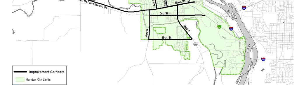
2 Mandan Corridors

3 Study Schedule Study Kick Off August 2015 Existing Conditions Evaluation Sept-Dec 2015 Public Meeting 1 January 2016 Alternatives Development March 2016 Public Meeting 2 March 2016 Alternatives Evaluation April/May 2016 Public Meeting 3 June 2016 Prepare Report Document July/Aug 2016
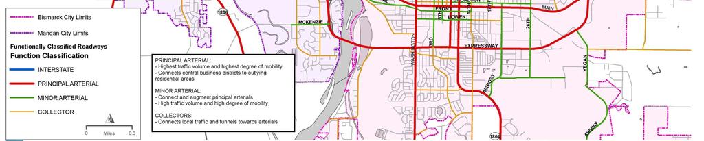
4 Roadway Functional Classification


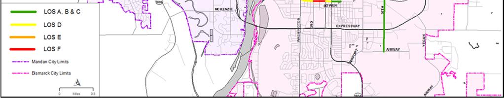
5 Projected 2040 Level of Service (LOS)

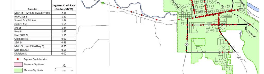
6 Analysis- Traffic Crashes

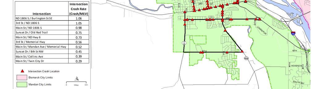
7 Analysis- Traffic Crashes

 at un-signalized intersections, If warranted Add advanced pedestrian crossing signage")
8 Main Street Corridor ND Hwy 25 to Twin City Drive Recommended Alternative No-build between Hwy 25 and 10th Avenue NW (Hwy 6) Install 3-lane section between 10th Avenue NW and 3rd Avenue NE Maintain on-street parking on north side Add on-street parking on the south side Lengthen right-turn lane at major intersections Coordinate all traffic signals and add protected left turn phasing at all signalized intersections. Re-stripe all crosswalks and improve all crosswalks Install Pedestrian Hybrid Beacon, (HAWK beacon) at un-signalized intersections, If warranted Add advanced pedestrian crossing signage at the intersections of 2nd Avenue NW and 4th Avenue NW The anticipated construction cost is $910,000. This cost includes $780,000 for HAWK beacons


9 Sunset Drive/6 th Avenue Corridor Main Street to Old Red Trail Recommended Alternative No-build between Main Street and North ramp terminal of the I-94/Sunset Drive Interchange Intersection of Sunset Drive and Old Red Trail Install a dedicated right turn lane Remove the channelized right-turn lane Narrow the through lane for the southbound traffic Add clear advanced signage for drivers South ramp terminal of the I-94/Sunset Drive Interchange Install signal control on channelized right turn on eastbound-tosouthbound approach Coordinate timing of signals at the I-94 westbound and eastbound ramp terminals with the signal at Old Red Trail The anticipated construction cost is $180,000
 Install advance intersection signing Install intersection lighting The anticipated construction cost is")
10 ND Highway 6 Corridor 19 th Street to Main Street Recommended Alternative No-build between 19 th Street and Main Street Intersection of ND Hwy 6 and 19 th Street Install a southbound left turn lane and a northbound right turn lane (Currently under development) Install advance intersection signing Install intersection lighting The anticipated construction cost is $235,000


11 Old Red Trail Corridor Mandan Avenue to Sunset Drive Recommended Alternative No-build between Mandan Avenue and Sunset Drive Intersection of Old Red Trail and Mandan Avenue Flatten horizontal curve Add advance intersection signing Consolidate Tesoro access to one approach as a radial T intersection Provide left and right turn lanes The anticipated construction cost is $700,000.

12 Mandan Avenue Corridor Main Street to Old Red Trail Recommended Alternative No-build between Main Street and Old Red Trail Intersection of Mandan Avenue and Main Street Update and restripe the pavement markings on intersection approaches Add lane extension skips through the intersection to help drivers navigate Add overhead lane designation signs on mast arms of traffic signal The anticipated construction cost is $13,000
")
 Intersection of 3 rd Street and Memorial Highway Add curb and gutter or guardrail along radius The anticipated construction")
13 3 rd Street Corridor ND Hwy 6 to Memorial Highway Recommended Alternative No-build between ND Hwy 6 and Memorial Highway Intersection of 3 rd Street and 9 th Avenue Replace 4-way stop with 2-way stop Add Pedestrian Signing Install Pedestrian Hybrid Beacon, (HAWK beacon) Intersection of 3 rd Street and 8 th Avenue Replace 4-way stop with 2-way stop Add Pedestrian Signing Install Pedestrian Hybrid Beacon, (HAWK beacon) Intersection of 3 rd Street and Memorial Highway Add curb and gutter or guardrail along radius The anticipated construction cost is $264,000


14 19 th Street Corridor ND Hwy 6 to ND Hwy 1806 Recommended Alternative Extend the existing urban section from Ridge Drive to HWY 6 with a 3-lane section No on-street parking Extend the existing urban section from 14 th Avenue SE to ND Hwy 1806 with a 3-lane section No on-street parking Provide turn lanes to all major intersections between Ridge Drive and ND Hwy 6 3-lane section between Ridge Drive and 14th Avenue SE No on-street parking The anticipated construction cost is 3,411,000


15 Collins Avenue Corridor Main Street to Old Red Trail Recommended Alternative No-build between Main Street and Old Red Trial Intersections of Collins Avenue at 5 th Street NE, 7 th Street NE and Division Street offset retaining walls at the 5 th Street NE Intersection of Collins Avenue and 14th Street Replace 4-way stop with a 2-way stop Signalize if warranted Intersection of Collins Avenue and Old Red Trail o Because of the proposed Starion Sports Complex intersection improvements may be needed Install traffic signal and left turn lanes in all quadrants or Install a roundabout The anticipated construction cost is $390,000

 at the pedestrian crossing, if warranted.")
16 ND Hwy 1806N Corridor 38 th Street to Old Red Trail Recommended Alternative No-build between 38th Street and Old Red Trail Intersection of ND Hwy 1806 N and 27 th Street NW Install left turn lane on northbound ND Hwy 1806 Install right turn lane on southbound ND Hwy 1806 Install right/left turn lanes on the eastbound on 27 th Street Install a Pedestrian Hybrid Beacon (HAWK beacon) at the pedestrian crossing, if warranted. The anticipated construction cost is $322,000


17 ND Hwy 1806S Corridor Main Street to 19 th Street SE Recommended Alternative 3-lane section between 3 rd Street SE to Main Street No on-street parking Intersection of ND Hwy 1806 S and 3 rd Street SE Extend curb and gutter around radius in NW quadrant Line up left turn lane offsets on the east and west approaches Utilize the boulevard on the east approach Dedicated right turn lane on the north approach Dedicated left turn lane on south approach No-build between 3 rd Street SE and 19 th Street SE Note: Aerial photo is out of date. Does not show development in NE quadrant

 at the pedestrian crossing Install left turn lane on")
18 ND Hwy 1806S Corridor (Continued) Main Street to 19 th Street SE Recommended Alternative Intersection of ND Hwy 1806 S and Burlington St. Add a pedestrian crossing and sidewalk along the east side of ND 1806 S (6th Avenue SE) Install traffic signal if warranted If signal not warranted install a Pedestrian Hybrid Beacon (HAWK beacon) at the pedestrian crossing Install left turn lane on ND 1806 S on the south approach and right turn lane on north approach The anticipated construction cost is $405,000

19 Division Street Corridor Sunset Drive to 8 th Avenue NE Recommended Alternative No-build between Sunset Drive and 8 th Avenue NE Intersection of Division St and Sunset Drive Restripe stop bar Trim vegetation and prune trees Intersection of Division St and 6 th Avenue NW Eliminate yield and stop control for Division Street approaches The anticipated construction cost is $13,700
20 Corridor Improvement Prioritization The corridors are listed in order of highest priority (1) to lowest priority (11) below: 1. Main Street /Business I-94 (ND Highway 25 to Twin City Drive) 2. Collins Avenue (Main Street to Oil Red Trail) 3. 3rd Street (ND Highway 6 to Memorial Highway) 4. Sunset Drive/6th Avenue NW (Main Street to Oil Red Trail) 5. ND Highway 1806 South (Main Street to 19th Street) 6. ND Highway 6 (Main Street to 19th Street NW) 7. Old Red Trail (Mandan Avenue to Sunset Drive) 8. Mandan Avenue/ND Highway 1806 (Main Street to Old Red Trail) 9. ND Highway 1806 North (Old Red Trail to 38th Street) th Street (ND Highway 6 to ND Highway 1806) 11. Division Street (Sunset Avenue to 8th Avenue NE)


21 Truck Route Evaluation Current Truck Average Daily Traffic (ADT)
22 Truck Route Alternatives
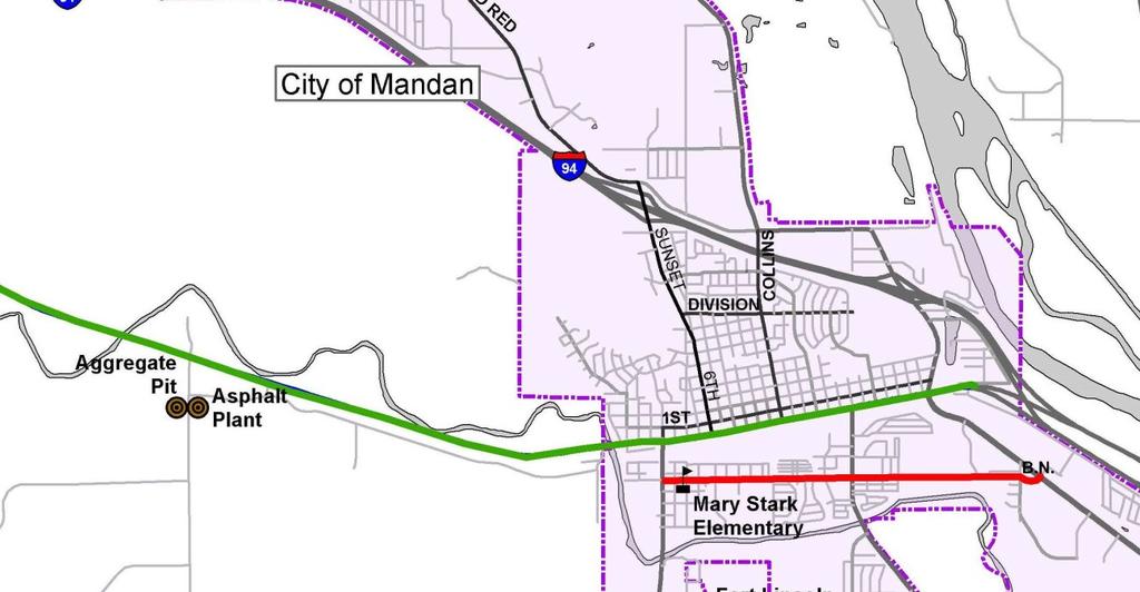
23 Truck Route Recommendation Relocation of aggregate pit and the asphalt plant Anticipated cost for reconstructing 45 th Street The no build alternative is being recommended

24 Questions or Comments?
Joshua Jester, E.I., Florida Department of Transportation, District One
 MEMORANDUM To: From: Joshua Jester, E.I., Florida Department of Transportation, District One Michael Garau, P.E., Kimley-Horn and Associates, Inc. Date: October 5, 2018 Subject: at Gulfstream Avenue Intersection
FDOT Treasure Coast Traffic Report
 July 6, 2018 Barbara Kelleher, 954 777 4090 Barbara.Kelleher@dot.state.fl.us FDOT Treasure Coast Traffic Report July 6 through July 13, 2018 TREASURE COAST Construction and maintenance related lane closures
122 Avenue: 107 Street to Fort Road
 : 107 Street to Fort Road November 24, 2015 4:30 8:00 p.m. Meeting Purpose Summarize project work completed to date Share results of public input from Phase 1 Share the draft concept plan and proposed
ICBC invests $1.175 million to help make Surrey, Delta and White Rock s roads safer in 2013
 Date: March 18, 2014 Page: 1 of 8 Media contacts: Michelle Hargrave, 250-979-4642 Lindsay Olsen, 604-982-4759 ICBC invests $1.175 million to help make Surrey, Delta and White Rock s roads safer in 2013
FDOT Treasure Coast Traffic Report
 July 13, 2018 Barbara Kelleher, 954 777 4090 Barbara.Kelleher@dot.state.fl.us FDOT Treasure Coast Traffic Report July 13 through July 20, 2018 TREASURE COAST Construction and maintenance related lane closures
5. MODIFICATIONS AT JEANNE D ARC BOULEVARD/REGIONAL ROAD 174 INTERCHANGE INTERSECTION - PUBLIC HEARING COMMITTEE RECOMMENDATION
 5. MODIFICATIONS AT JEANNE D ARC BOULEVARD/REGIONAL ROAD 174 INTERCHANGE INTERSECTION - PUBLIC HEARING COMMITTEE RECOMMENDATION Having held a public hearing, that Council approve the preliminary designs
TRAFFIC ACTION PLAN. Laurie Meadows Neighborhood CITY OF SAN MATEO
 TRAFFIC ACTION PLAN Laurie Meadows Neighborhood CITY OF SAN MATEO Draft January 2017 Table of Contents Introduction... 2 The Traffic Forum Process... 5 Neighborhood Traffic Issues... 7 Neighborhood Recommendations
A Sample Report of TRAFFIC CONTROL DEVICES REVIEW
 A Sample Report of TRAFFIC CONTROL DEVICES REVIEW Introduction We performed a peer review of traffic control devices at selected locations on the City s street system. As the result of our review, we have
Supervisor Cook Announces Final Plans for Braddock Road Improvement Project
 Supervisor Cook Announces Final Plans for Braddock Road Improvement Project After more than two years of study and significant community input, I am pleased to announce the final plans for the Braddock
PEDESTRIAN SAFETY IMPROVEMENT EVALUATION GUIDELINE FOR UNCONTROLLED CROSSINGS
 PEDESTRIAN SAFETY IMPROVEMENT EVALUATION GUIDELINE FOR UNCONTROLLED CROSSINGS Traffic Safety Engineering Division Updated: April 2018 EXECUTIVE SUMMARY NDOT Traffic Safety Engineering Division developed
DEPARTMENT OF ENVIRONMENTAL SERVICES. North Harrison Street (Lee Highway to Little Falls Road) Comparative Analysis. Prepared for:
 Comparative Analysis. Prepared for:") DEPARTMENT OF ENVIRONMENTAL SERVICES North Harrison Street (Lee Highway to Little Falls Road) Comparative Analysis Prepared for: Arlington County Department of Environmental Services 2100 Clarendon Boulevard,
DEPARTMENT OF ENVIRONMENTAL SERVICES North Harrison Street (Lee Highway to Little Falls Road) Comparative Analysis Prepared for: Arlington County Department of Environmental Services 2100 Clarendon Boulevard,
AGENDA ITEM 6 D THOMASVILLE ROAD (HERMITAGE BOULEVARD TO LIVE OAK PLANTATION ROAD) ROADWAY SAFETY AUDIT
 ROADWAY SAFETY AUDIT") May 15, 2018 AGENDA ITEM 6 D THOMASVILLE ROAD (HERMITAGE BOULEVARD TO LIVE OAK PLANTATION ROAD) ROADWAY SAFETY AUDIT TYPE OF ITEM: Discussion STATEMENT OF ISSUE The Florida Department of Transportation
May 15, 2018 AGENDA ITEM 6 D THOMASVILLE ROAD (HERMITAGE BOULEVARD TO LIVE OAK PLANTATION ROAD) ROADWAY SAFETY AUDIT TYPE OF ITEM: Discussion STATEMENT OF ISSUE The Florida Department of Transportation
Summary: Mercer County Princeton Avenue & Spruce Street Study January 2009
 Summary: Several recent studies have assessed potential development and redevelopment opportunities in the Mercer Crossing area of Trenton, Ewing, and Lawrence. This Princeton Avenue and Spruce Street
Pine Hills Road Pedestrian/Bicycle Safety Study Board of County Commissioners Work Session
 Pine Hills Road Pedestrian/Bicycle Safety Study Board of County Commissioners Work Session February 20, 2018 Meeting Agenda Study Overview Existing Conditions Access Management Potential Gateway Features
Chapter 4: Funding and Implementation
 Chapter 4: Funding and Implementation 83 84 Cost Estimating Cost estimating is an iterative process. When a project is in the conceptual stage, preliminary cost estimates are also provided conceptually,
PROJECT NO. 093 MA 199 H C. FEDERAL NO. xxxx WIKIEUP-WICKENBURG-PHOENIX HIGHWAY TEGNER STREET, ALTERNATIVE 10 PROJECT IMPROVEMENT
 PROJECT NO. 093 MA 199 H 5807 01C FEDERAL NO. xxxx WIKIEUP-WICKENBURG-PHOENI HIGHWAY TEGNER STREET, ALTERNATIVE 10 PROJECT IMPROVEMENT (INTERSECTION IMPROVEMENT) US 93/US 60 FINAL PROJECT ASSESSMENT April
Route 117 Review of Ownership Transfer October 2014
 Route 117 Review of Ownership Transfer October 2014 Page 1 of 27 I. INTRODUCTION... 3 II. EXISTING CONDITIONS... 4 A. Town of Lancaster Site-Investigation... 4 B. Town of Bolton Site-Investigation... 9
1. Provide a dedicated westbound approach bus lane at the intersection;
 3. MODIFICATIONS AT HIGHWAY 417 WESTBOUND OFF-RAMP/PINCREST ROAD - PUBLIC HEARING COMMITTEE RECOMMENDATIONS Having held a public hearing, that Council approve the preliminary design for the proposed modifications
Addendum to SDDCTEA Pamphlet 55 17: Better Military Traffic Engineering Revision 1 Effective: 24 Aug Crosswalk Guidelines
 Addendum to SDDCTEA Pamphlet 55 17: Better Military Traffic Engineering Revision 1 Effective: 24 Aug 2017 Crosswalk Guidelines Warrants for Uncontrolled Crosswalk Locations Crosswalks at Midblock Locations
Duwamish Way-finding and CTR Report
 V. North Tukwila When the North Tukwila Manufacturing and Industrial Center was designated in 1992 as part of the region s land use and transportation plan, the plan called for the area to set a light-rail
Typical Cross Section: DOWNTOWN (Observer Highway - 8th Street)
") Typical Cross Section: DOWNTOWN (Observer Highway - 8th Street) DRAFT SEPTEMBER 23, 14 1 Washington Street Typical Block Downtown Typical Block: DOWNTOWN (Observer Highway - 8th Street) New crosswalks
Typical Cross Section: DOWNTOWN (Observer Highway - 8th Street) DRAFT SEPTEMBER 23, 14 1 Washington Street Typical Block Downtown Typical Block: DOWNTOWN (Observer Highway - 8th Street) New crosswalks
CSAH 101 Preliminary Design
 CSAH 101 Preliminary Design Public Open House No. 2 January 29, 2013 CSAH 62 to Hutchins Drive Welcome / Introductions Hennepin County Craig Twinem, Transportation Maury Hooper, Transportation Nick Peterson,
Los Altos Hills Town Council - June 18, 2015 Palo Alto City Council June 22, AGENDA ITEM #2.B Presentation
 Los Altos Hills Town Council - June 18, 2015 Palo Alto City Council June 22, 2015 AGENDA ITEM #2.B Presentation Previous Presentations Los Altos Hills Town Council in May 2014 and February 2015 Palo Alto
2014/2015 BIKE ROUTE PLAN 83 AVENUE PROTECTED BIKE LANE
 About the Project 2014/2015 BIKE ROUTE PLAN The City of Edmonton is planning a major bike route on the south side of Edmonton. This bike route is one part of a plan to provide citizens with transportation
Agenda. Overview PRINCE GEORGE S PLAZA METRO AREA PEDESTRIAN PLAN
 PRINCE GEORGE S PLAZA METRO AREA PEDESTRIAN PLAN May 28, 2008 Agenda Welcome and introductions Project overview and issue identification Planning context and strengths Design challenges and initial recommendations
Project Report. South Kirkwood Road Traffic Study. Meadows Place, TX October 9, 2015
 Meadows Place, TX October 9, 2015 Contents 1 Introduction... 1 2 Data Collection... 1 3 Existing Roadway Network... 2 4 Traffic Volume Development... 2 5 Warrant Analysis... 3 6 Traffic Control Alternative
Active Transportation Facility Glossary
 Active Transportation Facility Glossary This document defines different active transportation facilities and suggests appropriate corridor types. Click on a facility type to jump to its definition. Bike
City of Sammamish. Welcome. Issaquah-Fall City Road Improvements Project Phase I Design: 242nd Avenue SE to Klahanie Drive SE
 Welcome Welcome to the third community meeting for the Issaquah-Fall City Road Improvements Project. AGENDA 6:00 p.m. Welcome and sign-in 6:10 p.m. Presentation 6:50 p.m. Open house Learn about the roadway
PLACEMENT OF SIGNS RECOMMENDED PRACTICES SUB-SECTION
 Page 1 of 6 RECOMMENDED PRACTICES PART SECTION SUB-SECTION HIGHWAY SIGNS GENERAL General Proper positioning of signs is an important element in the overall control of traffic within a roadway network.
Date: February 18, 2015 Page: 1 of 9. ICBC invests $1.195 million to improve Surrey, Delta & White Rock roads
 News release Date: February 18, 2015 Page: 1 of 9 Media contacts: Lindsay Olsen, 604-982-4759 ICBC invests $1.195 million to improve Surrey, Delta & White Rock roads You may have noticed the new pedestrian
Complete Streets Funding Program Project Prioritization Plan
 Funding Program Project Prioritization Plan Location and Type Needs South Street Crosswalk Installation Stripe a new formalized crosswalk across South Street at the Anne T. Dunphy School pedestrian path
2014/2015 BIKE ROUTE PLAN 83 AVENUE PROTECTED BIKE LANE
 About the Project The City of Edmonton is planning a major bike route on the southside of Edmonton. The Strathcona Bike Route will connect the communities of Strathcona, Garneau and the University area,
APPENDIX D COST SUMMARY TABLES
 APPENDIX D COST SUMMARY TABLES Section 1 Between Route 50 and Evergreen Mills Road 3850 linear feet of one 12 foot wide additional lane in southbound direction of Rte 606; from north side of Rte 50 to
Broadway Street Pedestrian Safety Study Cass Street to 700 Feet North of Randall Avenue
 Broadway Street Pedestrian Safety Study Cass Street to 700 Feet North of Randall Avenue Prepared for: City of De Pere, Wisconsin Prepared by: June, 2017 Broadway Street Pedestrian Safety Study Cass Street
FY STATEWIDE TRANSPORTATION IMPROVEMENT PROGRAM New Jersey Department of Transportation Projects
 Barclay Street Viaduct NS9807 NS9807 This project will provide for the rehabilitation of the Barclay Street Viaduct, from Route 19 to Marshall Street, in order to increase the weight load of the structure.
FY STATEWIDE TRANSPORTATION IMPROVEMENT PROGRAM New Jersey Department of Transportation Projects
 ROUTE/ Project ID No. TIP No. Electrical Load Center Replacement - North 04324 04324 This project will provide for the betterment of the existing highway lighting facilities located along Routes 3, 17
Donahue Drive Corridor Traffic Operational Evaluation
 Donahue Drive Corridor Traffic Operational Evaluation PREPARED FOR: THE CITY OF AUBURN PREPARED BY: JANUARY 2007 Donahue Drive Corridor Study--Auburn, Alabama TABLE OF CONTENTS Introduction... 1 Background
TECH MEMOS #3 & #4 EXISTING AND FUTURE TRAFFIC CONDITIONS TRAVEL FORECASTING APPROACH CITY OF NOVI THOROUGHFARE MASTER PLAN
 TECH MEMOS #3 & #4 EXISTING AND FUTURE TRAFFIC CONDITIONS TRAVEL FORECASTING APPROACH CITY OF NOVI THOROUGHFARE MASTER PLAN January, 2016 1. Introduction This report is prepared as part of the 2016 Novi
Hennepin County Transportation Department
 Hennepin County Transportation Department Complete Streets Design and Implementation Prepared for the Complete Streets Task Force Craig Twinem, P.E. Design Division Manager Tom Johnson, P.E. Transportation
Meeting Schedule 7:00-7:15 Open House 7:15-7:45 Existing Conditions/Short-Term Improvements Study Presentation 7:45-8:00 Q&A Session 8:00-8:10
 Meeting Schedule 7:00-7:15 Open House 7:15-7:45 Existing Conditions/Short-Term Improvements Study Presentation 7:45-8:00 Q&A Session 8:00-8:10 Long-Term Study Presentation 8:10-8:40 Table Discussions 8:40-9:00
Ottawa Beach Road Study
 Ottawa Beach Road Study Prepared For: Park Township September 30, 2014 Project No. G140303 OTTAWA BEACH ROAD STUDY PREPARED FOR: PARK TOWNSHIP SEPTEMBER 30, 2014 PROJECT NO. G140303 TABLE OF CONTENTS 1.0
ICBC invests $738,000 to make Surrey, White Rock and Delta roads safer
 For release: Immediately Page: 1 of 5 Date: April 2, 2012 Ref #: 2012-11 Media contacts: Karon Trenaman, 604-527-8766 ICBC invests $738,000 to make Surrey, White Rock and Delta roads safer You ve likely
INTERSTATE 540 IMPROVEMENT STUDY
 INTERSTATE 540 IMPROVEMENT STUDY WASHINGTON COUNTY AND BENTON COUNTY APRIL, 2006 INTERSTATE 540 IMPROVEMENT STUDY WASHINGTON COUNTY AND BENTON COUNTY April, 2006 Prepared by Parsons Transportation Group
Omaha s Complete Streets Policy
 Omaha s Complete Streets Policy (Adopted August 2015) VISION To create great places and enhance our quality of life, the City of Omaha will provide safe, accessible streets for all users. Complete Streets
Poor pavement condition Substandard Intersections. / Substandard bike/pedestrian/transit accommodations. Driveway access Environmental concerns
 Public Informational Meeting University Avenue (Allen Boulevard Segoe Road) March 23, 2011 City of Madison City of Middleton Village of Shorewood Hills Dane County Existing Roadway Conditions Poor pavement
Updated There is no park access points beyond the limit of the phase I work. roadway to be constructed Viewport has been along full limits of the park
 The signs will be installed as Temporary signs the color (Orange/White) have been added to the plans. Need to specify color to be used for stripes. Closures that may be in place for extended periods need
FDOT Broward County Traffic Impact Report November 24 through December 1, 2017
 FDOT Broward County Traffic Impact Report November 24 through December 1, 2017 FORT LAUDERDALE -- Construction and maintenance-related lane closures on state highways in Broward County are expected during
Existing Conditions. Date: April 16 th, Dan Holderness; Coralville City Engineer Scott Larson; Coralville Assistant City Engineer
 Date: April 16 th, 2015 To: From: Re: Dan Holderness; Coralville City Engineer Scott Larson; Coralville Assistant City Engineer Darian Nagle-Gamm, Traffic Engineering Planner Highway 6 (2 nd Street) /
Brooklyn Boulevard (County Road 152) Reconstruction Project Phase I. OPEN HOUSE June 20, 2017
 Reconstruction Project Phase I. OPEN HOUSE June 20, 2017") Brooklyn Boulevard (County Road 152) Reconstruction Project Phase I OPEN HOUSE June 20, 2017 Brooklyn Boulevard (County Road 152) Phase I Project Partners Project Lead Other Project Partners include Brooklyn
Brooklyn Boulevard (County Road 152) Reconstruction Project Phase I OPEN HOUSE June 20, 2017 Brooklyn Boulevard (County Road 152) Phase I Project Partners Project Lead Other Project Partners include Brooklyn
INDEX. Geometric Design Guide for Canadian Roads INDEX
 Acceleration lane, see Lanes, Acceleration Access, 8.1 Access Management and Functional Classification 8.2 Access Management by Design Classification 8.3 Access Configuration 8.4 Building Set-Back Guidelines
APPENDIX E GRADE CROSSING LOCATIONS
 APPENDIX E GRADE CROSSING LOCATIONS 1 2 3 Citrus Avenue Riverside County and City Palmyrita Avenue Columbia Avenue MP 0.57 002X-0.6 027301Y MP 1.00 002X-1.0 027302F MP 1.24 002X-1.3 027303M 1. Existing
CRESTON ROAD COMPLETE AND SUSTAINABLE STREETS CORRIDOR PLAN
 CRESTON ROAD COMPLETE AND SUSTAINABLE STREETS CORRIDOR PLAN Preferred Plan Community Presentation September 27, 2017 City of El Paso de Robles in partnership with: Local Government Commission, W-Trans,
Offset Single Point Interchange I-25 at Rio Bravo Boulevard Albuquerque, New Mexico
 Offset Single Point Interchange I-25 at Rio Bravo Boulevard Albuquerque, New Mexico INSTITUTE OF TRANSPORTATION ENGINEERS 2016 WESTERN DISTRICT MEETING JULY 11, 2016 7/11/2016 1 Project Vicinity Map 7/11/2016
Clybourn Ave. Protected Bike Lane Study Halsted St. to Division St.
 Clybourn Ave. Protected Bike Lane Study Halsted St. to Division St. Nathan Roseberry, Senior Engineer Pam Broviak, Project Manager July 24, 2014 Agenda Project Goals Existing Roadway Conditions Traffic
CITY OF LANCASTER PROPOSED NEW PROJECTS
 CITY OF LANCASTER 2013-2014 PROPOSED NEW PROJECTS Project Code 11 Facilities and Fixtures Project Title 1 11BS018 Main. Yard Storage Bldg, Phase 2 2 11GS007 Parks Improvements 3 11GS008 Dog Park AHP 4
May 10, 2013 Meredith Cruz, (561) Palm Beach County Traffic Report May 10 through May 17, 2013
 Palm Beach County Traffic Report May 10 through May 17, 2013") May 10, 2013 Meredith Cruz, (561) 641-6440 mcruz@corradino.com Palm Beach County Traffic Report May 10 through May 17, 2013 Palm Beach County Palm Beach County traffic will be affected this week by ongoing
May 10, 2013 Meredith Cruz, (561) 641-6440 mcruz@corradino.com Palm Beach County Traffic Report May 10 through May 17, 2013 Palm Beach County Palm Beach County traffic will be affected this week by ongoing
Acknowledgements. Mr. David Nicol 3/23/2012. Daniel Camacho, P.E. Highway Engineer Federal Highway Administration Puerto Rico Division
 Daniel Camacho, P.E. Highway Engineer Federal Highway Administration Puerto Rico Division Acknowledgements Mr. David Nicol Director, FHWA Office of Safety FHWA Office of Safety http://safety.fhwa.dot.gov/provencountermeasures/
Pedestrian Road Safety Audit
 Pedestrian Road Safety Audit Middlebrook Road From Father Hurley Boulevard to Waring Station Road December 2017 Montgomery County Department of Transportation Table of Contents 1. Introduction... 1 1.1
Downtown Signals Traffic Analysis
 Downtown Signals Traffic Analysis City of St. Mary s April 16, 2018 Presented by: Allan Heitbrink, P.E. & Craig Eley, P.E. Who We Are Craig Eley, P.E o o o Previously the ODOT D7 Traffic and Safety Engineer.
FDOT Broward County Traffic Report April 20 through April 27, 2018
 FDOT Broward County Traffic Report April 20 through April 27, 2018 FORT LAUDERDALE -- Construction and maintenance-related lane closures on state highways in Broward County are expected during the week
CAPITOL DRIVE & FOND DU LAC AVENUE INTERSECTION ANALYSIS. Urban Planning 772 SARAH BREGANT, RYAN PETERSON, & MATT WERDERITCH
 CAPITOL DRIVE & FOND DU LAC AVENUE INTERSECTION ANALYSIS Urban Planning 772 SARAH BREGANT, RYAN PETERSON, & MATT WERDERITCH OVERVIEW N 51 ST BOULEVARD N 51 ST BOULEVARD 12,100 44,700 W CAPITOL DRIVE 52,600
SR/CR A1A PEDESTRIAN SAFETY & MOBILITY STUDY
 SR/CR AA PEDESTRIAN SAFETY & MOBILITY STUDY PEDESTRIAN / BICYCLE SAFETY REVIEW Focus Area H / 9th Street S to 3th Street N Prepared for: River to Sea Transportation Planning Organization 2570 West International
City of Gainesville Transportation/Roadway Needs PROJECT SUMMARY
 A1 Roadway Resurfacing $23,846,000 TYPE: Preservation of existing system Roadway resurfacing A2 Signal Replacement $6,000,000 TYPE: Preservation of existing system Replace traffic signals. B1 W 6th St
Washington St. Corridor Study
 Washington St. Corridor Study Prepared for Grand Forks-East Grand Forks Metropolitan Planning Organization Prepared by Kadrmas, Lee & Jackson, Inc. Final Report Washington St. Corridor Study Grand Forks
Fleur Drive Reconstruction
 Fleur Drive Reconstruction October 29, 2018 1 Agenda: Fleur Drive Reconstruction Project Scope & Cost Overview Fleur Drive Cross Section Elements - Travel Lane Widths - Sidewalk Widths - Parkway Widths
Broad Street Bicycle Boulevard Design Guidelines
 Broad Street Bicycle Boulevard Design Guidelines Building from the strategies introduced in the 2013 Bicycle Transportation Plan and community input received thus far, City Transportation Staff have identified
Design Criteria. Design Criteria
 F Design Criteria Design Criteria Ministry of Transportation Ministère des Transports DESIGN CRITERIA Page: 1 of 13 WORK PROJECT NO. N/A GO Bloomington Station TYPE OF PROJECT LOCATION Bloomington Road
Huntington Station Metro Zone / North Kings Highway Concept Plan
 Summary Narrative of Huntington Station Metro Zone / North Kings Highway Concept Plan Located in Fairfax County, Virginia prepared for A.J. Dwoskin & Associates, Inc.. 9302 Lee Highway, Suite 300 Fairfax,
City of Scotts Valley CITY COUNCIL STAFF REPORT
 DATE: April 19, 2017 City of Scotts Valley CITY COUNCIL STAFF REPORT AGENDA ITEM 2 DATE: 4-19-2017 TO: FROM: APPROVED: SUBJECT: Honorable Mayor and City Council Scott Hamby, Public Works Director Jenny
Meadow Woods Elementary School
 Drag and drop pic and stretch/crop to the limits of the blue rectangle (delete this text box) Meadow Woods Elementary School Drag and drop pic and stretch/crop to the limits of the blue rectangle (delete
Public Information Meeting. Orange Camp Road. Dr. Martin Luther King Jr. Beltway to I-4. Presented by: Volusia County August 2, 2018
 Public Information Meeting Orange Camp Road Dr. Martin Luther King Jr. Beltway to I-4 Presented by: Volusia County August 2, 2018 1 Project Goals To improve the operations and safety for Orange Camp Road
Orange Center Elementary School
 Drag and drop pic and stretch/crop to the limits of the blue rectangle (delete this text box) Orange Center Elementary School Drag and drop pic and stretch/crop to the limits of the blue rectangle (delete
Howell Mill Road Safety Audit Report, DRAFT
 Howell Mill Road Safety Audit Report, 7-28-2015 DRAFT Present: Jonathan Lewis (City of Atlanta), Forrest Rose (City of Atlanta), Kwesi Nantambu & Jeremy (City of Atlanta Department of Public Works), Matthew
Brian McHugh, Buckhead Community Improvement District. SUBJECT: Wieuca Road at Phipps Boulevard Intersection Improvements Project
 MEMO TO: FROM: Brian McHugh, Buckhead Community Improvement District Jagan Kaja, AICP, WSP Parsons Brinckerhoff SUBJECT: Wieuca Road at Phipps Boulevard Intersection Improvements Project DATE: October
Traffic Signal Phasing Study Summary & Staff Recommendations
 Traffic Signal Phasing Study Summary & Staff Recommendations Consultant Study by Skipper Consulting, Inc. Staff Committee Recommendations by Randy Pewitt, Executive Director of Emergency Mgt. and Safety
FY 2004 TRANSPORTATION CAPITAL PROGRAM New Jersey Department of Transportation Projects
 Avenue P Bridge 03315 This project will address potential construction in the vicinity of the Avenue P Bridge. SPONSOR: City of Newark Bridge Preservation - Local Bridges NJTPA 288 DES STATE $400,000 CARGOMATE
CITY OF OTTAWA ROADWAY MODIFICATION APPROVAL UNDER DELEGATED AUTHORITY
 RMA-2015-ATM-038 CITY OF OTTAWA ROADWAY MODIFICATION APPROVAL UNDER DELEGATED AUTHORITY DATE: April 22, 2015 SUBJECT Approval of Roadway Modifications Recommended through an Area Traffic Management Study
TRANSPORTATION ANALYSIS REPORT US Route 6 Huron, Erie County, Ohio
 TRANSPORTATION ANALYSIS REPORT US Route 6 Huron, Erie County, Ohio December 12, 2012 Prepared for: The City of Huron 417 Main Huron, OH 44839 Providing Practical Experience Technical Excellence and Client
Draft North Industrial Area-Wide Traffic Plan
 Summary of North Industrial and Hudson Bay Industrial Recommended Improvements Table 1. Summary of s Item Location 1 2 3 4 5 6 7 8 9 10 11 12 Millar Ave north of 51st St Super 8 Motel back lane 400 Block
Roundabout Evaluations in Virginia: US 15/US 50 Gilberts Corner, VA SR 106/SR 634 Prince George County, VA
 Roundabout Evaluations in Virginia: US 15/US 50 Gilberts Corner, VA SR 106/SR 634 Prince George County, VA VDOT & FHWA Roundabout Workshop September 17, 2013 Chris Tiesler, PE Presentation Outline US 15/US
DUNBOW ROAD FUNCTIONAL PLANNING
 DUNBOW ROAD FUNCTIONAL PLANNING Final Report August 3, 216 #31, 316 5th Avenue NE Calgary, AB T2A 6K4 Phone: 43.273.91 Fax: 43.273.344 wattconsultinggroup.com Dunbow Road Functional Planning Final Report
WEDNESDAY, SEPTEMBER 6, :00 PM City Council Chambers, 1 Civic Center Drive, San Marcos, CA 92069
 MINUTES Meeting of the San Marcos Traffic Commission WEDNESDAY, SEPTEMBER 6, 2017 6:00 PM City Council Chambers, 1 Civic Center Drive, San Marcos, CA 92069 CALL TO ORDER: Vice Chairman Rico called the
Dr. M.L. King, Jr. Street North Complete Streets Resurfacing Opportunities HOUSING, LAND USE, AND TRANSPORTATION COMMITTEE MARCH 22, 2018
 Dr. M.L. King, Jr. Street North Complete Streets Resurfacing Opportunities HOUSING, LAND USE, AND TRANSPORTATION COMMITTEE MARCH 22, 2018 What s Happening The City plans to mill and resurface Dr. M.L.
Palm Beach County Traffic Report November 16 through November 23, 2018
 November 16, 2018 Barbara Kelleher, (954) 777 4090 Barbara.Kelleher@dot.state.fl.us Palm Beach County Traffic Report November 16 through November 23, 2018 Palm Beach County Palm Beach County traffic will
Designing for Pedestrian Safety. Alabama Department of Transportation Pre-Construction Conference May 2016
 Designing for Pedestrian Safety Alabama Department of Transportation Pre-Construction Conference May 2016 1 Designing for Pedestrians Marking Crosswalks at Signalized intersections High Visibility Markings
Military Road Safety Improvements
 Military Road Safety Improvements 26 th Road North to 31 st Street North SUMMARY OF DATA REVIEW AND PRELIMINARY RECOMMENDATIONS Prepared for: Department of Environmental Services Traffic Engineering and
Observations and Ideas: Toomer s Corner Streetscape Improvements
 Observations and Ideas: Toomer s Corner Streetscape Improvements AUBURN DOWNTOWN MASTER PLAN planning downtown s future August 26, 2013 Observations: Vertical Clutter at Corners 6 3 7 5 9 2 8 4 1 Excess
Scarlett Road Bridge & Road Improvements Lambton Park Community School - Gymnasium Tuesday November 28 th, 2017
 Scarlett Road Bridge & Road Improvements Lambton Park Community School - Gymnasium Tuesday November 28 th, 2017 PROJECT LOCATION 2 SCARLETT ROAD BRIDGE Constructed in 1912, the bridge carries 4 active
ADA Training Accessible Pedestrian Signal (APS) 2018 MnDOT
 2018 MnDOT") ADA Training Accessible Pedestrian Signal (APS) 2018 MnDOT APS and ADA APS is not currently an ADA Standard and is provided at the discretion of the Title II entity APS is recognized in the MnMUTCD, but
ADA Training Accessible Pedestrian Signal (APS) 2018 MnDOT APS and ADA APS is not currently an ADA Standard and is provided at the discretion of the Title II entity APS is recognized in the MnMUTCD, but
Small Area Study U.S. Route 220 and VA Route 615 Intersection. Bath County, Virginia
 Small Area Study U.S. Route 220 and VA Route 615 Intersection Bath County, Virginia Prepared by the Central Shenandoah Planning District Commission Final Report February 2018 Table of Contents 1. INTRODUCTION...
Lynchburg District Update
 Lynchburg District Update Virginia Statewide Bicycle and Pedestrian Advisory Committee Spring Meeting May 16 th, 2017 David Cook Transportation Planner, VDOT Lynchburg District Table of Contents Active
Pedestrian and Bicycle Safety Program Leg Agency Title of Project Project Description Dist
 2015-17 and Bicycle Safety Program Leg Lummi Nation 42 Kennewick 8 Lummi Nation 42 Jamestown S'Klallam 24 WSDOT-- NW 32 Port of Vancouver 49 Spokane 3 Seattle 46 Shoreline 32 Lummi Shore Drive Columbia
Glenn Avenue Corridor Traffic Operational Evaluation
 Glenn Avenue Corridor Traffic Operational Evaluation PREPARED FOR: THE CITY OF AUBURN PREPARED BY: DECEMBER 2007 Glenn Avenue Corridor Study--Auburn, Alabama TABLE OF CONTENTS Introduction... 1 Background
INNOVATIVE INTERSECTION DESIGN
 INNOVATIVE INTERSECTION DESIGN J. Eddie Valtier, P.E. ELP TP&D Director Introduction Why Do We Need To Start Looking For Innovative Intersection Designs? Congestion is worsening and traffic volumes and
A plan for improved motor vehicle access on Railroad Avenue in Provincetown
 A plan for improved motor vehicle access on Railroad Avenue in Provincetown February 2011 A plan for improved motor vehicle access on Railroad Avenue in Provincetown INTRODUCTION AND PROBLEM IDENTIFICATION
Project Team. Refined Pedestrian Crossing Toolbox. Problem Statement. Aerial of Study Corridor. Crossing Accommodations and Pedestrian Fatalities
 Project Team Refined Pedestrian Crossing Toolbox Treatments on Wide, High Speed Urban Roadways Developed as Part of the Springfield Main Street (OR 126) Safety Study Consultants Scott Mansur, P.E., P.T.O.E.
PRINCE GEORGE S PLAZA METRO AREA PEDESTRIAN PLAN
 PRINCE GEORGE S PLAZA METRO AREA PEDESTRIAN PLAN May 28, 2008 Agenda Welcome and introductions Project overview and issue identification Planning context and strengths Design challenges and initial recommendations
GEOMETRIC DESIGN STANDARDS FOR NEW RESIDENTIAL SUBDIVISION STREETS TABLE 1A CG-6 CURB AND GUTTER SECTION
 TABLE 1A CG-6 CURB AND GUTTER SECTION HORIZONTAL AND VERTICAL CONTROLS CURB AND GUTTER ROADWAYS MAXIMUM 3:1 CUT OR FILL SLOPE CURVE DATA MIN. SIGHT DISTANCE PROJECTED TRAFFIC VOLUME (ADT) MIN. DESIGN SPEED
Welcome. Thank you for your interest in the Lewis & Clark Viaduct Concept Study
 Welcome Thank you for your interest in the Lewis & Clark Viaduct Concept Study Please use the arrows in the upper left hand corner to navigate through the presentation. Use the envelope icon to ask a question
Engineering Countermeasures for Transportation Safety. Adam Larsen Safety Engineer Federal Highway Administration
 Engineering Countermeasures for Transportation Safety Adam Larsen Safety Engineer Federal Highway Administration 360-619-7751 Adam.Larsen@DOT.GOV Countermeasure Selection Resources Manual for Selecting