Active Neighborhood Checklist: Protocol
|
|
|
- Trevor Knight
- 6 years ago
- Views:
Transcription


1 Active Neighborhood Checklist: Protocol Version 2.0 (February 2011) Contact: Christine Hoehner, PhD, MSPH Washington University in St. Louis or (314)

2 Audit Tool - Definition Systematic assessment of factors in the physical and social environment that hinder or facilitate physical activity 2
3 Goals of an Audit: The 3 A s Advocacy An audit can be used to identify needs in the community for advocacy initiatives (e.g., no safe routes to school). Action Research An audit can be used in the needs assessment phase of intervention research (e.g., the most accessible place to build a new walking trail). Analytic Research An audit can be used to determine the factors in the environment that influence physical activity behavior. 3
4 Audit Tool Characteristics It can be detailed or simplistic. It can be comprehensive or focused. It can be subjective or objective. It can be costly or inexpensive. It can complement other sources of data. 4
5 Purpose of the User-Friendly Active Neighborhood Checklist To serve as a short, user-friendly audit tool that assesses the most important features of the street-scale environment for physical activity Designed for community members and public health practitioners for research and advocacy. 5
6 Other Resources Two-page protocol for the Active Neighborhood Checklist Hoehner CM et al. Active Neighborhood Checklist: A User-Friendly and Reliable Tool for Assessing Activity Friendliness Am J Health Promot 2007;21:
7 Getting Started 7
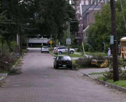
8 Street Segment - Definition A section of street or road (1/4 mile or less) between two adjacent intersections or between an intersection and cul-de-sac (dead end). Street segment 8
9 Street Segment - Definition Roads with few intersections should be divided into two or more ¼-mile segments. Short segments may be combined with adjacent segments. A street with a T-intersection may be audited as two separate segments (e.g., 1 and 2 below). A reference point should be noted on the continuous side so that the recorded information is not duplicated for the adjacent segments
10 Maps 10
11 Materials Audit tool Map Clipboard Pencil/pen Comfortable shoes Watch Cell phone Sunscreen Umbrella Camera take photos for illustrations and to make note of questionable features 11
12 Labeling Date: Enter today s date (4/8, 4/15, 4/22) Segment ID: Enter team ID + number (e.g. A1) Auditor ID: Enter your name Neighborhood ID: See map Street Name: Enter street and intersecting segments (e.g., Elm between 1 st and 2 nd Street) Start time: Enter time Stop time (on 2 nd page): Don t forget! 12
13 Labeling -- Example Date: 4/8/05 Segment ID: A2 (2 nd segment audited by team A) Auditor ID: Christy Neighborhood ID: Kirkwood Street Name: Elm between 1 st and 2 nd Street Start time: 10:45 am Stop time: 10:55 am 13


14 Is any building or section of the sidewalk or roadway under construction or being repaired? For buildings only note major renovation or construction (i.e., not repair of a roof on a single home) 14
15 What land uses are present? 15
16 1. Are residential and nonresidential land uses present? All residential Both residential and non-residential All non-residential 16
17 1. Are residential and nonresidential land uses present? Example 1: (red = non-residential, white=residential): Single family Single family Single family Apartment complex 17
18 1. Are residential and nonresidential land uses present? Example 2: (red = non-residential, white=residential): Single family Single family Single family Strip mall with 4 stores 18
19 1. Are commercial and residential land uses mixed? Example 4: (red = non-residential, white=residential): 6-family home 6-family home 6-family home Church and parking lot 19
20 1. Are commercial and residential land uses mixed? Example 6: (red = non-residential, white=residential): Apt over retail Apt over retail Apt over retail Strip mall with 8 shops 20
21 1. Are commercial and residential land uses mixed? Example 7: (red = non-residential, white=residential): Single family Single family Single family Park 21
22 1. Are commercial and residential land uses mixed? Example 7: (red = non-residential, white=residential): Single family Single family Single family Undeveloped Land 22
23 2. What is the predominant land use? Residential buildings/yards Commercial or public/government buildings School/school yards Parking lots or garages Park with exercise/sport facilities or playground equipment Vacant lot/abandoned building Undeveloped land Designated green space (includes park with no exercise/play facilities) Other non-residential, specify: 23

24 Park with facilities 24

25 Vacant lot / abandoned building Vacant lots: A lot about the same size as buildings on the segment or nearby segments with visible signs of neglect. Abandoned building: Uninhabited building that shows visible signs of neglect. 25


26 Undeveloped land Large area of natural space that is not maintained by public or private entities. 26

.")
27 Designated green space Large area of natural space that is maintained by public or private entities and open to the public but lacks designated places to play or exercise (e.g., trail, playground). 27
28 Where to count specific types of land uses for items in section A3-A6 Users that intend to aggregate the data may want to avoid double-counting destinations when they are located on the corner of 2 segments. Double-counting is acceptable if the land uses are used to characterize the type of street (e.g., commercial or residential). Double-counting should be avoided if the land uses are used to calculate densities of segments with a specific type(s) of destination(s) (e.g., % of segments with a grocery store). 28
29 Where to count specific types of land uses for items in section A3-A6 When users prefer not to double-count destinations, they should count destinations based on: Address Front of building Maple Only count this school on the Elm segment Elm 29
30 Where to count specific land uses for Section A4 Count parking lots based on: The segment which contains the building that the parking lot is used for Entrance Size Maple Elm 30
31 3. What types of residential uses are present? None Abandoned homes Single family homes Multi-unit homes (2-4 units) Apartments or condominiums (>4 units, 1-4 stories) Apartments or condominiums (>4 units, >4 stories) Apartment over retail Other (retirement home, mobile home, dorms) Note: to distinguish between single and multi-unit homes, look for multiple mailboxes or doorbells. 31
32 4. What parking facilities are None present? On-street, including angled parking Small lot or garage (<30 spaces) Medium to large lot Garage Note: If pavement is unmarked, code as On-street (angled or parallel) parking only if there are cars parked within the segment or if parking signs are present. For streets that permit on-street parking on weekends or evenings only, mark as None and document varying parking rules in notes. 32

33 5. What public recreational facilities and equipment are present (including in the schoolyard if publicly accessible)? None Park with exercise/sport facilities or playground equipment Off-road walking/biking trail Sports / playing field Basketball / tennis / volleyball court Playground Outdoor pool Other: 33
34 Public parks or schoolyards Do not include: Church playgrounds Daycare playgrounds Apartment playgrounds Gated and locked schoolyards Note the above in the Land use notes 34
35 Off-Road Walking, Bicycling, or Multi-Use Trail? Counts as a sidewalk AND an off-road walking trail 35
36 5. What types of nonresidential uses are present? Abandoned/vacant blg Specific types of destinations Small grocery, convenience store or pharmacy Supermarket Food establishments (restaurant, bakery, café, coffee shop, bar) Entertainment (e.g., movie theater, arcade) Library or post office Bank Laundry/dry cleaner Indoor fitness facility Educational facilities School (elementary, middle, high school) College, technical school, or university Large blgs housing 1+ businesses/ services High-rise building (>5 stories) Big box store (e.g., Walmart, Office Depot, Best Buy) Mall Strip mall Large office building, warehouse, factory or industrial building 36
37 Abandoned building Uninhabited building that shows visible signs of neglect. Does not include homes or commercial buildings that are for sale unless there are obvious signs of neglect. If a large number of houses or commercial buildings are for sale, note this in the Land use notes. 37
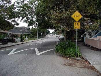
38 Indoor fitness facility Examples Health club Yoga/pilates Dance studios Public recreation centers YMCA Indoor tennis club 38

39 Big Box Store Examples include: Walmart Borders Home Depot Does not include destinations counted elsewhere: Supermarkets Factories Office building 39
 Generally used to")

40 Strip Mall A strip mall typically has a name (e.g., Clock Tower Center) Generally used to depict auto-oriented design Count strip mall as well as specific destinations in them. 40
41 Land use notes Include: Major natural landscape features (e.g., lakes, rivers) Major barriers (e.g., railroad tracks, highway) Other distinct characteristics Questions you have regarding classifying types of destinations 41
42 Is Public Transportation Available? 42


43 Transit Stop (Bus, Train, or Other) 43


44 Bench or Covered Shelter at Transit Stop? 44
45 What Street Characteristics are Visible? 45


46 Posted Speed Limit or Special Speed Zone Posted speed limit Special speed zone 46

47 One-Lane Street 47
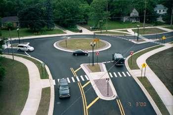
48 Two-Lane Street 48

49 Three-Lane Street 1 X

50 Four-Lane Street 1 2 x


51 Marked Lanes? Marked Unmarked 51
52 Median or Pedestrian Island 52


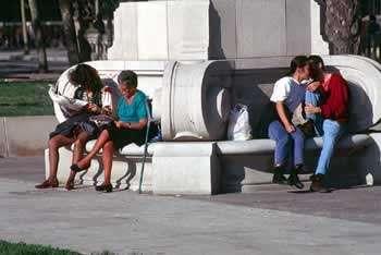
53 Turn Lane? A turn lane should be a special lane designated for turning 53


54 Stop sign or traffic light for crossing this segment? 54


55 Any stop light missing pedestrian signal? 55


56 Crosswalk for Crossing This Segment? 56

57 Traffic Calming Devices (Roundabout, Curb Extension, Speed Bump) 57


58 Cul-de-sac Present (dead end street)? Sidewalk Cut-Through in Cul-de-Sac? Yes, cul-de-sac Yes, sidewalk cut-through Yes, cul-de-sac No, sidewalk cut-through 58
59 Street Characteristic Notes: Description of: Traffic volume or speed Condition of crossing aids Lots of cars pulling in and out of drive ways 59
60 What is the quality of the environment? 60

61 Any Commercial Building Adjacent to Sidewalk? No Yes Enter 99 if not applicable (e.g., no sidewalk or no commercial buildings) 61


62 Bench? Excluding benches at bus stop and benches in parks 62

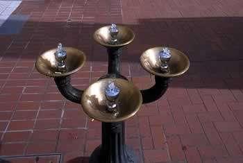
63 Drinking Fountain? 63

64 Public Art? 64
65 Pedestrian-Scale Lighting Yes No 65


66 Graffiti or Broken/Boarded Windows? Try to limit boarded windows to those that reflect physical disorder 66


67 Litter or Broken Glass? A lot None or a little 67


68 Tree Shade on the Walking Area No/little shade Some A lot 68
69 Slope Along the Walking Area This item is somewhat subjective Compare your street to a flat street and a street with a steep slope. A flat or gentle slope would hardly be noticeable to most individuals Walking on a moderate slope may increase someone s heart rate, but would not act as a barrier for most individuals A steep slope would act as a barrier to someone who is not active or who has physical 69 limitations


70 Pedestrian Environment Notes: Description of: Cross-slopes Distinct or attractive features that make this segment especially pleasing to a pedestrian (e.g., street furniture, lots of flower boxes, awnings) 70
71 Do you have a place to walk or bicycle? 71
72 Response choices No Yes, one side Yes, both sides 72

73 Sidewalk Present? 73


74 Off-Road Walking, Bicycling, or Multi-Use Trail? Counts as a sidewalk AND an off-road walking trail 74


75 Any Grassy or Other Buffer Between Curb and Sidewalk along most of the segment? Buffer No Buffer 75

76 Any Grassy or Other Buffer Between Curb and Sidewalk along most of the segment? Buffer? Yes, but make note of material 76

77 Tree(s) in Buffer? 77


78 Sidewalk Continuous Within Segment Not continuous Continuous 78


79 Sidewalk Continuous Between Segments at Both Ends? NOT continuous Continuous 79


80 Width > 3 ft for Most of Sidewalk? Yes, but make note of sidewalk merging with parking lot 80


81 Width <3ft for Any Part of Sidewalk No Yes 81

82 Any Missing Curb Cuts or Ramps at Intersections or Driveways? Yes No 82


83 Any Major Bumps, Cracks, Holes or Weeds in the Sidewalk? Yes 83


84 Any Major Bumps, Cracks, Holes or Weeds in the Sidewalk? No 84
 Blocking")

85 Any Permanent Obstructions (e.g., Trees, Signs, Tables) Blocking the 3-ft Walk Area? Only an obstruction if it blocks the 3-foot walking area 85

86 If A Sidewalk is Not Present on Any Part of the Segment, Do You Have Another Safe Place to Walk? 86
87 Sidewalk Notes Description of Curb cuts Misalignments Obstructions Sidewalk width 87


88 Designated Bike Route Sign or Marking Share the Road Sign? 88


89 On Street, Paved, and Marked Shoulder? Width of Marked Shoulder >=4 ft? Shoulder (Use measured foot or tape measure for width if safe) Not a shoulder 89


90 Shoulder Continuous Between Segments at Both Ends? 90
 Drainage grates are only an obstruction when the holes are aligned with bicycle path Leaves or branches should not be considered")
91 Permanent Obstruction in the Shoulder (including drainage grates, parked cars?) Drainage grates are only an obstruction when the holes are aligned with bicycle path Leaves or branches should not be considered a permanent obstruction This is not an obstruction 91

92 If Paved, Marked Shoulder is Not Present on Any part of the Segment, Do You Have Another Safe Place to Bicycle? Street, if little traffic Wide outside lane 92
93 Shoulder Notes: Description of: Traffic volume or speed Condition of bike lane Obstructions 93

94 Sample Street 94

95 Sample Street 95
Tool used and their usefulness Google Map/Earth Google Street View Microsoft Visual Oblique
 (1) Use all three tools for your assessment (2) If the tool can not determine the criteria, check Can not be determined (3) Indicate the tools used (4) Rate the effectiveness of the tool LAND USE ENVIRONMENT
Audit information collected by: Foot Auto Both. Location information collected by: Foot Auto Both LAND USE ENVIRONMENT
 Audit information collected by: Foot Auto Both Location information collected by: Foot Auto Both LAND USE ENVIRONMENT 1. Are residential and non-residential land uses visible in this segment? Integration
ACTIVE TRANSPORTATION Active Community Checklist
 ACTIVE TRANSPORTATION Active Community Checklist Safe, accessible spaces to walk, hike, bike and play is an important part of building strong, healthy and active communities for residents and visitors.
Route Item and Subscale Reliability Table All Countries
 Route Item and Subscale Reliability Table All Countries Route Land Use: Residential Density Item Item Content Range N Inter-Rater Agreement Rater Mean (SD) Frequencies LU2a Single family homes 0-1 407.926
How walk, bike, and transit friendly is your neighbourhood?
 How walk, bike, and transit friendly is your neighbourhood? What is an 8-80 City? 8-80 Cities are communities built for everyone regardless of age or ability. These communities reflect social equality
MAPS DATA DICTIONARIES - ABBREVIATED
 MAPS DATA DICTIONARIES - ABBREVIATED 1. Data Entry Dictionary: variable names and item-level coding Route: Destinations and Land Use Section LU1 How is audit information collected? Foot (walked route)
Healthy Corridor Audit Tool
 Healthy Corridor Audit Tool How to Use:»» Complete the first section for the entire study area. Many indicators can be collected from existing data; they do not have to be collected on site.»» To assess
Active Transportation Audit
 Intersection: Municipality: Audit Conducted By (Name): Time of Audit: Date and Day of Week: Weather Conditions: Active Transportation Audit A. Pedestrian Facilities Please indicate north direction Street
12/4/2016 VIA . RE: Grocery Outlet Del Paso (DR16-328)
") 12/4/2016 VIA EMAIL Ethan Meltzer, Assistant Planner City of Sacramento Community Development Department 300 Richards Blvd, 3 rd Floor Sacramento, CA 95811 RE: Grocery Outlet Del Paso (DR16-328) Dear Mr.
12/4/2016 VIA EMAIL Ethan Meltzer, Assistant Planner City of Sacramento Community Development Department 300 Richards Blvd, 3 rd Floor Sacramento, CA 95811 RE: Grocery Outlet Del Paso (DR16-328) Dear Mr.
All Season Age Friendly Pedestrian Safety and Walkability Checklist *
 FOSTERING AGE FRIENDLY, WALKABLE NEIGHBOURHOODS Walkability is a key component of optimal aging in Age Friendly cities. Walkable neighbourhoods promote physical and mental health and well-being, support
Clarkson Walkability Audit: Results and Recommendations Summary
 Clarkson Walkability Audit: Results and Recommendations Summary The following document was prepared by the Region of Peel and includes a summary of comments made by participants during our breakout discussion
NEWS-CFA: Confirmatory Factor Analysis Scoring for Neighborhood Environment Walkability Scale (Updated: March 15, 2011)
") NEWS-CFA: Confirmatory Factor Analysis Scoring for Neighborhood Environment Walkability Scale (Updated: March 15, 2011) The NEWS is a self-report perceived environment survey originally developed by Saelens
NEWS-CFA: Confirmatory Factor Analysis Scoring for Neighborhood Environment Walkability Scale (Updated: March 15, 2011) The NEWS is a self-report perceived environment survey originally developed by Saelens
ASSESSING THE WALKING & BIKING ENVIRONMENT
 ASSESSING THE WALKING & BIKING ENVIRONMENT M A Y 2 0 1 3 Jon Morgan WI DHS ACTIVE COMMUNITY LINE-UP Rationale Why do an audit What s involved in an audit Things to look for and consider Hitting the streets
WALKABILITY CHECKLIST How walkable is your community?
 WALKABILITY CHECKLIST How walkable is your community? Everyone benefits from walking and other forms of active transportation. These benefits include: improved fitness, cleaner air, reduced risks of certain
Illustrated Principles of Good Planning
 Illustrated Principles of Good Planning The Miami 21 Zoning Code incorporates time-tested planning principles into the zoning regulations of our City. These are principles that make for better neighborhoods,
NJDOT Complete Streets Checklist
 Background The New Jersey Department of Transportation s Complete Streets Policy promotes a comprehensive, integrated, connected multi-modal network by providing connections to bicycling and walking trip
3/10/2016 VIA th Street, Suite 203 Sacramento, CA
 3/10/2016 VIA EMAIL Arwen Wacht, Associate Planner City of Sacramento Community Development Department 300 Richards Boulevard, 3 rd Floor Sacramento, CA 95811 RE: Natomas Fountains (P16-012) Dear Ms. Wacht:
Microscale Audit of Pedestrian Streetscapes (MAPS), Mini Version
, Mini Version") Microscale Audit of Pedestrian Streetscapes (MAPS), Mini Version Training Manual & Picture Guide Developed by: Carrie Geremia Kelli Cain Revised February 11, 2014 Tool and protocol developed by: James
Microscale Audit of Pedestrian Streetscapes (MAPS), Mini Version Training Manual & Picture Guide Developed by: Carrie Geremia Kelli Cain Revised February 11, 2014 Tool and protocol developed by: James
Neighborhood Environment Walkability Scale Youth (NEWS-Y) Parent Version
 Parent Version") Neighborhood Environment Walkability Scale Youth (NEWS-Y) Parent Version From Active Where? study Information on scoring can be found at: http://www.drjamessallis.sdsu.edu/documents/news-yscoring.pdf Suggested
Neighborhood Environment Walkability Scale Youth (NEWS-Y) Parent Version From Active Where? study Information on scoring can be found at: http://www.drjamessallis.sdsu.edu/documents/news-yscoring.pdf Suggested
Fill in the rating for each section. Total up the ratings to see how your neighbourhood scores overall for walkability.
 WALKABILITY CHECKLIST How walkable is your community? Everyone benefits from walking and other forms of active transportation. These benefits include: improved fitness, cleaner air, reduced risks of certain
SPACES INSTRUMENT: OBSERVERS MANUAL
 SURVEY OF THE PHYSICAL ENVIRONMENT IN LOCAL NEIGHBOURHOODS SPACES INSTRUMENT: OBSERVERS MANUAL Contact: Terri Pikora Health Promotion Evaluation Unit Department of Public Health The University of Western
5/7/2013 VIA . RE: University Village Safeway Expansion (P13-019)
") 5/7/2013 VIA EMAIL David Hung, Associate Planner Community Development Department, Current Planning Division City of Sacramento 300 Richards Boulevard, 3 rd Floor Sacramento, CA 95811 RE: University Village
5/7/2013 VIA EMAIL David Hung, Associate Planner Community Development Department, Current Planning Division City of Sacramento 300 Richards Boulevard, 3 rd Floor Sacramento, CA 95811 RE: University Village
Neighborhood Environment Walkability Scale Youth (NEWS-Y) Adolescent Version
 Adolescent Version") Neighborhood Environment Walkability Scale Youth (NEWS-Y) Adolescent Version From Active Where? study Information on scoring can be found at: http://www.drjamessallis.sdsu.edu/documents/news-yscoring.pdf
Neighborhood Environment Walkability Scale Youth (NEWS-Y) Adolescent Version From Active Where? study Information on scoring can be found at: http://www.drjamessallis.sdsu.edu/documents/news-yscoring.pdf
Active Transportation Facility Glossary
 Active Transportation Facility Glossary This document defines different active transportation facilities and suggests appropriate corridor types. Click on a facility type to jump to its definition. Bike
7/23/2017 VIA . Michael Hanebutt City of Sacramento Community Development Department 300 Richards Boulevard, 3 rd Floor Sacramento, CA 95811
 7/23/2017 VIA EMAIL Michael Hanebutt City of Sacramento Community Development Department 300 Richards Boulevard, 3 rd Floor Sacramento, CA 95811 RE: 65 th Street Apartments (DR17-220) Dear Mr. Hanebutt:
9/22/2014 VIA . RE: Butano Apartments Pre App (PAMP )
") 9/22/2014 VIA EMAIL Surinder Singh, Senior Planner Planning and Environmental Review Division Sacramento County 827 7th Street, Second Floor RE: Butano Apartments Pre App (PAMP2014-00012) Dear Mr. Singh:
9/22/2014 VIA EMAIL Surinder Singh, Senior Planner Planning and Environmental Review Division Sacramento County 827 7th Street, Second Floor RE: Butano Apartments Pre App (PAMP2014-00012) Dear Mr. Singh:
Steps to Conducting a Complete Streets Assessment
 Steps to Conducting a Complete Streets Assessment Familiarize yourself with Complete Streets Read through the Complete Streets Assessment Guidelines. This will give you an idea of what Complete Streets
5 CIRCULATION AND STREET DESIGN
 5 CIRCULATION AND STREET DESIGN This chapter describes circulation and streetscape improvements proposed for the Northwest Chico Specific Plan Area. It includes detailed design specifications for existing
5/31/2016 VIA . Arwen Wacht City of Sacramento Community Development Department 300 Richards Blvd., 3 rd Floor Sacramento, CA 95811
 5/31/2016 VIA EMAIL Arwen Wacht City of Sacramento Community Development Department 300 Richards Blvd., 3 rd Floor Sacramento, CA 95811 RE: El Pollo Loco (P16-028) Dear Ms. Wacht: WALKSacramento has reviewed
9/21/2016 VIA . RE: The Knot (DR16-270)
") 9/21/2016 VIA EMAIL Garrett Norman, Assistant Planner City of Sacramento Community Development Department 300 Richards Boulevard, 3 rd Floor Sacramento, CA 95811 RE: The Knot (DR16-270) Dear Mr. Norman:
9/21/2016 VIA EMAIL Garrett Norman, Assistant Planner City of Sacramento Community Development Department 300 Richards Boulevard, 3 rd Floor Sacramento, CA 95811 RE: The Knot (DR16-270) Dear Mr. Norman:
CHAPTER 16 PEDESTRIAN FACILITIES DESIGN AND TECHNICAL CRITERIA TABLE OF CONTENTS
 CHAPTER 16 PEDESTRIAN FACILITIES DESIGN AND TECHNICAL CRITERIA TABLE OF CONTENTS Section Title Page 16.1 General... 16-1 16.1.1 AASHTO Reference... 16-1 16.1.2 ADA Requirements... 16-1 16.2 Sidewalks...
8/31/2016 VIA . RE: Freeport Arco Fuel Station (P16-039)
") 8/31/2016 VIA EMAIL Garrett Norman, Assistant Planner City of Sacramento Community Development Department 300 Richards Boulevard, 3 rd Floor Sacramento, CA 95811 RE: Freeport Arco Fuel Station (P16-039)
8/31/2016 VIA EMAIL Garrett Norman, Assistant Planner City of Sacramento Community Development Department 300 Richards Boulevard, 3 rd Floor Sacramento, CA 95811 RE: Freeport Arco Fuel Station (P16-039)
Sidewalk Accessibility Checklist
 Starting Address: Ending Address: Date: Sidewalk Accessibility Checklist Please indicate your experience with any barriers you encountered when using the sidewalks in your neighborhood. 1. Did you have
6/14/2013 VIA . Evan Compton, Associate Planner Community Development Department City of Sacramento 300 Richards Blvd Sacramento, CA 95814
 6/14/2013 VIA EMAIL Evan Compton, Associate Planner Community Development Department City of Sacramento 300 Richards Blvd RE: Sacramento Natural Foods Co-Op (P13-025) Dear Mr. Compton: WALKSacramento appreciates
APPENDIX A: Complete Streets Checklist DRAFT NOVEMBER 2016
 APPENDIX A: Complete Streets Checklist DRAFT NOVEMBER 2016 Complete Streets Checklist MetroPlan Orlando s Complete Streets Checklist is an internal planning tool for staff to further implementation of
10/30/2012 VIA
 10/30/2012 VIA EMAIL David Hung, Associate Planner Community Development Department, Current Planning Division City of Sacramento 300 Richards Blvd., 3 rd Floor Sacramento, CA 95811 RE: The Cannery On-Site
Walking Audit Supporting Information
 Walking Audit Supporting Information Planning to do a walking audit of your streets? Here s some helpful suggestions to help get you started. 1. Preparing for your audit Decide where you want to walk.
10/8/2014 VIA . RE: CVS Pharmacy (P13-002) Revised August 2014
 Revised August 2014") 10/8/2014 VIA EMAIL David Hung, Associate Planner Community Development Department, Current Planning Division City of Sacramento 300 Richards Boulevard, 3 rd Floor Sacramento, CA 95811 RE: CVS Pharmacy
10/8/2014 VIA EMAIL David Hung, Associate Planner Community Development Department, Current Planning Division City of Sacramento 300 Richards Boulevard, 3 rd Floor Sacramento, CA 95811 RE: CVS Pharmacy
N_RD_ N_RD_ N_RD_ N_RD_ N_RD_ N_RD_6
 Neighborhood Environment Walkability Survey We would like to find out more information about the way that you perceive or think about your Please answer the following questions about your neighborhood
T A B L E OF C O N T E N T S
 T A B L E OF C O N T E N T S PART III SUBDIVISION REGULATIONS OF THE DEPARTMENT OF PUBLIC WORKS, C & C D PAGE PAGE Responsibility for Development of Streets......... 29 Right-of-Way Widths...... 37 Purpose...........
11/3/2014 VIA . WALKSacramento has reviewed the Stockton and T Mixed-Use project at 3675 T Street in the
 11/3/2014 VIA EMAIL Antonio Ablog Planning Department City of Sacramento 300 Richards Boulevard Sacramento, CA 95811 RE: Design Review for Stockton and T Mixed-Use (P14-042) Dear Mr. Ablog: WALKSacramento
GIS Based Data Collection / Network Planning On a City Scale. Healthy Communities Active Transportation Workshop, Cleveland, Ohio May 10, 2011
 The Purpose of GIS Based Network Planning GIS Based Data Collection / Network Planning Healthy Communities Active Transportation Conference Tuesday, May 10, 2011 10:00 AM Norman Cox, LLA, ASLA. Ann Arbor,
3/20/2015 VIA . Teresa Haenggi, Associate Planner Community Development Department 300 Richards Blvd. Sacramento, CA 95811
 3/20/2015 VIA EMAIL Teresa Haenggi, Associate Planner Community Development Department 300 Richards Blvd. Sacramento, CA 95811 RE: Ice Blocks (P14-062) Dear Ms. Haenggi: WALKSacramento has reviewed the
Vision: Traditional hamlet with an attractive business/pedestrian friendly main street connected to adjacent walkable neighborhoods
 N D. Focus Area II Vision: Traditional hamlet with an attractive business/pedestrian friendly main street connected to adjacent walkable neighborhoods Transit Road Focus Area II is located in the Hamlet
complete streets design and construction standards public primer City of Edmonton
 complete streets design and construction standards public primer City of Edmonton introduction Complete Streets are streets for everyone: people who walk, wheel, bike, take transit, or drive. They are
MAG Town of Cave Creek Bike Study Task 6 Executive Summary and Regional Significance Report
 Page 1 MAG Town of Cave Creek Bike Study Task 6 Executive Summary and Regional Significance Report August 1, 2012 MAG Project #481 Page 2 Task 6 Executive Summary and Regional Significance Report Introduction
STEERING COMMITTEE MEETING June 17, Streetscape Overview Burlington Comprehensive Master Plan
 STEERING COMMITTEE MEETING June 17, 2015 Streetscape Overview Burlington Comprehensive Master Plan 1 Introduction Slide This slide show was presented to the Burlington Steering Committee on June 17, 2015
This chapter describes the proposed circulation system and transportation alternatives associated with
 5.0 Circulation 5.1 OVERVIEW This chapter describes the proposed circulation system and transportation alternatives associated with West Landing, and summarize the information contained in the Existing
Bicycle and Pedestrian Facilities Toolbox (Excerpt from Figure 3.1)
") Appendix B Neighborhood Connections Summaries This Appendix is a supplement to the information presented in Chapter 3 Connect People. The Appendix includes a summary or profile for each of the proposed
Appendix B Neighborhood Connections Summaries This Appendix is a supplement to the information presented in Chapter 3 Connect People. The Appendix includes a summary or profile for each of the proposed
RIVERSIDE, Newton MA BH NORMANDY RIVERSIDE LLC. Riverside Station. A green, transit-oriented community
 Riverside Station A green, transit-oriented community October 6, 2011 TONIGHT S AGENDA: 1. Project Update (5 min.) 2. Master Plan Update (10 min.) 3.Traffic Plan Update (10 min.) Questions & Answers MASTER
Multimodal Through Corridors and Placemaking Corridors
 68 Multimodal Through Corridors and Placemaking Corridors Corridors have different functions in a region. Some corridors are used to get smoothly and rapidly through a region or to get quickly to major
Roadway Classification Design Standards and Policies. Pueblo, Colorado November, 2004
 Roadway Classification Design Standards and Policies Pueblo, Colorado November, 2004 Table of Contents Page Chapter 1. General Provisions 1.1 Jurisdiction 3 1.2 Purpose and Intent 3 1.3 Modification 3
8/1/2018 VIA . Darcy Goulart City of Rancho Cordova Planning Department 2729 Prospect Park Drive Rancho Cordova, CA 95670
 8/1/2018 VIA EMAIL Darcy Goulart City of Rancho Cordova Planning Department 2729 Prospect Park Drive Rancho Cordova, CA 95670 RE: Towne Place Suites by Marriott Hotel (DD9806) Dear Ms. Goulart: WALKSacramento
Creating walkable, bikeable and transit-supportive communities in Halton
 Creating walkable, bikeable and transit-supportive communities in Halton By presenting current research and best practices, the information in this paper is meant to support and broaden discussion on how
Introduction. Using the Checklist. TDM-Supportive Development Design and Infrastructure Checklist Version 1.0 (30 June 2017) City of Ottawa
 City of Ottawa") Introduction The s Transportation Impact Assessment (TIA) Guidelines (specifically Module 4.1 Development Design) requires proponents of qualifying developments to use the City s TDM-Supportive Development
Introduction The s Transportation Impact Assessment (TIA) Guidelines (specifically Module 4.1 Development Design) requires proponents of qualifying developments to use the City s TDM-Supportive Development
CONNECTING PEOPLE TO PLACES
 CONNECTING PEOPLE TO PLACES 82 EAST BENCH MASTER PLAN 07 Introduction The East Bench transportation system is a collection of slow moving, treelined residential streets and major arteries that are the
COMMUNITY CHOICES EVENTS High Schools. February 13-22, 2014
 COMMUNITY CHOICES EVENTS High Schools February 13-22, 2014 In February 2014, the City held a series of events to gain public input on the Arvada Comprehensive Plan Update. Outreach included engaging approximately
Property Owner Survey Results
 Property Owner Survey Results 1. What are the most positive aspects of the Golden Mile? (check all that apply) Response Response Existing mix of businesses 50.0% 20 Good access to major roads 85.0% 34
Florida Coalition CTST COMMUNITY TRAFFIC SAFETY TEAMS COLLEGE OF MEDICINE
 CTST Florida Coalition COMMUNITY TRAFFIC SAFETY TEAMS COLLEGE OF MEDICINE How to Choose Your Lifelong Community A Transportation Checklist What Is a Lifelong Community? You might be more familiar with
RE: Park Plaza Walgreens (P12-016)
") 12/5/2014 VIA EMAIL David Hung, Associate Planner City of Sacramento Community Development Department 300 Richards Blvd., 3rd Floor Sacramento, CA 95811 RE: Park Plaza Walgreens (P12-016) Dear Mr. Hung:
12/5/2014 VIA EMAIL David Hung, Associate Planner City of Sacramento Community Development Department 300 Richards Blvd., 3rd Floor Sacramento, CA 95811 RE: Park Plaza Walgreens (P12-016) Dear Mr. Hung:
11/28/2016 VIA
 11/28/2016 VIA EMAIL Ethan Meltzer, Assistant Planner City of Sacramento Community Development Department 300 Richards Blvd., 3 rd Floor Sacramento, Ca 95811 RE: Natomas Corporate Center Commercial Building
FOCUS AREA 1 - Alberta Avenue Pocket Park 3 (121 Ave and 92 St)
") FOCUS AREA 1 - Alberta Avenue Pocket Park 3 (121 Ave and 92 St) New benches Plant evergreen trees Widen existing sidewalk from 1.5m to 1.8m Marked crosswalk 1.8m wide sidewalk Add pedestrian oriented lights
FOCUS AREA 1 - Alberta Avenue Pocket Park 3 (121 Ave and 92 St) New benches Plant evergreen trees Widen existing sidewalk from 1.5m to 1.8m Marked crosswalk 1.8m wide sidewalk Add pedestrian oriented lights
David Hung, Associate Planner City of Sacramento Community Development Department 300 Richards Boulevard, 3 rd Floor Sacramento, CA
 June 13, 2016 VIA EMAIL David Hung, Associate Planner City of Sacramento Community Development Department 300 Richards Boulevard, 3 rd Floor Sacramento, CA 959811 RE: Fire Station 14 (DR16-128) Dear Mr.
Appendix 3 Roadway and Bike/Ped Design Standards
 Appendix 3 Roadway and Bike/Ped Design Standards OTO Transportation Plan 2040 4/20/2017 Page A3-1 Adopted Standards The adopted OTO Design Standards and Major Thoroughfare Plan are contained herein.
Morristown, NJ Complete Streets Policy
 Morristown, NJ Complete Streets Policy Introduction A Complete Street is defined as a means to provide safe access for all users by designing and operating a comprehensive, integrated, connected multi-modal
Modifiers to LWS, if any
 Reporting and Scoring of CDC HAN Audit Tool Key Indicators, v. 1 19 16 Audit Tool Indicators January 2016 An overall summary is useful, i.e, with/without, etc. Analysis can look at block faces or combine
Access Management in the Vicinity of Intersections
 Access Management in the Vicinity of Intersections FHWA-SA-10-002 Technical Summary Photo: Ralph Bentley (used with permission) 0 Access Management is: The design, implementation and management of entry
Executive Summary Route 30 Corridor Master Plan
 Route Corridor Master Plan Project Overview The Route Corridor Master Plan is a coordinated multimodal transportation and land use plan for the entire stretch of Route through East Whiteland Township,
Aurora Urban Street Standards For Transit Oriented Developments and Urban Centers
 Aurora Urban Street Standards For Transit Oriented Developments and Urban Centers I. Purpose These standards will be applied to create a safe, comfortable, pleasant and pedestrian-friendly multi-modal
Table #6 VISION CHARACTERISTICS
 Table #6 VISION White Flint is a place to live, work, play, shop, and walk with sufficient density to encourage quality redevelopment. Vibrant streets and consistent streetscapes are important. CHARACTERISTICS
Bicycle and Pedestrian Advisory Committee (BPAC) November 21, 2013
 November 21, 2013") Bicycle and Pedestrian Advisory Committee (BPAC) November 21, 2013 OVERALL LAND USE CONCEPT Overall Broadway Valdez District: 95.5 acres (35.1 acres right-of ways + 60.4 acres developable land) Plan Subareas:
Bicycle and Pedestrian Advisory Committee (BPAC) November 21, 2013 OVERALL LAND USE CONCEPT Overall Broadway Valdez District: 95.5 acres (35.1 acres right-of ways + 60.4 acres developable land) Plan Subareas:
Presentation Comments and Questions
 Presentation Comments and Questions The community had a number of questions regarding the master plan process and operational issues in and around the MARC rail station areas. The bullet points below are
Garden City State Street Corridor Existing Conditions October 2012
 Garden City State Street Corridor Existing Conditions October 2012 Prepared by Garden City Development Services Leon Letson, Missy Harris & Jenah Thornborrow 6015 Glenwood Street Garden City, Idaho 83714
Measuring the Built Environment Using a Street Segment Instrument
 Measuring the Built Environment Using a Street Segment Instrument Sandy Slater, PhD (sslater@uic.edu) University of Illinois at Chicago, School of Public Health International Society for Behavioral Nutrition
DRAFT - CITY OF MEDFORD TRANSPORTATION SYSTEM PLAN Roadway Cross-Sections
 Roadway Cross-Sections Medford s roadway cross-section standards apply to new and reconstructed roads. The crosssections take into consideration roadway function and operational characteristics, including
o n - m o t o r i z e d transportation is an overlooked element that can greatly enhance the overall quality of life for the community s residents.
 N o n - m o t o r i z e d transportation is an overlooked element that can greatly enhance the overall quality of life for the community s residents. 84 Transportation CHAPTER 11 INTRODUCTION Transportation
Cross Street Corridor Non-Motorized Enhancement Project Project Description
 Cross Street Corridor Non-Motorized Enhancement Project Project Description A cooperative study of the Cross Street neighborhood was completed in May 2002 by the City of Ypsilanti, the Depot Town Downtown
SITE OBSERVATION FORM
 Sequential # Site ID: Sequential Number in pencil Injury Site B. Additional Site D. Additional Site E. Site type will be completed by the Study Coordinator after the Observation Form is completed. SITE
Use this guide to learn more about walkability and how you can make your community safer to walk
 Walkability Guide Do You Enjoy Walking In Your Community? Use this guide to learn more about walkability and how you can make your community safer to walk 2 About This Guide Circulate San Diego believes
Appendix B Results of Visual Preference Survey March 2017
 Lake Saint Louis Comprehensive Plan Appendix B Results of Visual Preference Survey March 2017 Our City. Our Plan. Our Future. WORKING DRAFT - NOV 2016 Visual Preference Survey OVERVIEW The Visual Preference
01. VICINITY OF GREENBRAE POC: EXISTING CONDITIONS
 01. VICINITY OF GREENBRAE POC: EXISTING CONDITIONS Existing Bus Stop Existing US101 On-ramp Existing POC Old Redwood Highway Rich Street City ROW Environmental Study Limit Industrial Way NO DESIGNATED
 COMPLETE STREETS CHECKLIST City of Philadelphia The City of Philadelphia's Complete Streets policies are designed ensure that city streets are safe, comfortable and convenient for people of all ages and
4/14/2017 VIA . Miriam Lim, Junior Planner City of Sacramento Community Development Department 300 Richards, 3 rd Floor Sacramento, CA 95811
 4/14/2017 VIA EMAIL Miriam Lim, Junior Planner City of Sacramento Community Development Department 300 Richards, 3 rd Floor Sacramento, CA 95811 RE: Mack & Franklin Development (P17-016) Dear Ms. Lim:
Item to be Addressed Checklist Consideration YES NO N/A Required Description Complete Streets Guidelines
 Passaic County Complete Streets Checklist - Concept Development Project Name Item to be Addressed Checklist Consideration YES NO N/A Required Description Complete Streets Guidelines Existing Plans Have
GIS Based Non-Motorized Transportation Planning APA Ohio Statewide Planning Conference. GIS Assisted Non-Motorized Transportation Planning
 The Purpose of GIS Assisted Network GIS Assisted Non-Motorized Transportation 2011 APA Ohio Statewide Conference Friday, 10:45 AM to Noon Focus on near-term projects wwwgreenwaycollabcom The purpose of
Montgomery County Life Sciences Center Loop Trail
 Montgomery County Life Sciences Center Loop Trail Advisory Committee Meeting #1 February 10, 2015 Agenda 1. Project Background 2. Existing Conditions Analysis 3. Examples from Elsewhere 4. Discussion Project
McLean Main Street Public Forum Follow-up
 McLean Main Street Public Forum Follow-up Sponsored & Hosted by John W. Foust, Dranesville District Supervisor McLean Planning Committee Fairfax County Office of Community Revitalization and Reinvestment
AND GUIDING PRINCIPLES. Boise, Idaho 1997
 USTICK CONCEPT MASTER PLAN AN AND GUIDING PRINCIPLES Boise City Comprehensiv ehensive e Plan Boise, Idaho 1997 GOALS, OBJECTIVES AND POLICIES BOISE CITY ~ NEIGHBORHOOD MASTER PLANS USTICK CONCEPT MASTER
6/22/2018 VIA . Darcy Goulart, Planning Manager City of Rancho Cordova Planning Department 2729 Prospect Park Drive Rancho Cordova, CA 95670
 6/22/2018 VIA EMAIL Darcy Goulart, Planning Manager City of Rancho Cordova Planning Department 2729 Prospect Park Drive Rancho Cordova, CA 95670 RE: Quick Quack Car Wash (DD9801) Dear Ms. Goulart: WALKSacramento
COWETA HIGH SCHOOL AND EAST HIGHWAY 51
 COWETA HIGH SCHOOL AND EAST HIGHWAY 51 Lack of sidewalks along Ben Lumpkin Rd. Lack of crosswalks and ramps at intersection. Hwy 51 is wide to cross as a pedestrian. No ADA compliance or connection to
11/3/2017 VIA . RE: River Oaks Phase 2 (P17-051)
") 11/3/2017 VIA EMAIL Ethan Meltzer, Assistant Planner City of Sacramento Community Development Department 300 Richards Blvd., 3 rd Floor Sacramento, CA 98811 RE: River Oaks Phase 2 (P17-051) Dear Mr. Meltzer:
11/3/2017 VIA EMAIL Ethan Meltzer, Assistant Planner City of Sacramento Community Development Department 300 Richards Blvd., 3 rd Floor Sacramento, CA 98811 RE: River Oaks Phase 2 (P17-051) Dear Mr. Meltzer:
CONNECTIVITY PLAN. Adopted December 5, 2017 City of Virginia Beach
 CONNECTIVITY PLAN Adopted December 5, 2017 City of Virginia Beach CONTENTS 1.0 Background & Purpose... 2 2.0 Existing Inventory & Analysis... 3 ViBe District Existing Walking Conditions... 4 3.0 ViBe District
A. Pedestrian Facility Design
 A. Pedestrian Facility Design Photo by Dan Burden Photo by Cara Seiderman Walkways are the portion of the public right-of-way that provide a separated area for people traveling on foot.walkways that are
Streets. Safe for Pedestrians 20% 2nd 5,000. Are We People-Friendly?
 Streets Safe for Pedestrians 20% Pedestrian deaths account for more than of all traffic-related fatalities in California each year. 600 More than people are killed and another 13,000 are injured every
Chapter 3: Multi-Modal Circulation and Streetscapes
 CHAPTER 3: MULTI-MODAL CIRCULATION AND STREETSCAPES Chapter 3: Multi-Modal Circulation and Streetscapes Overview Streetscape improvements have already been completed for Depot Street between Main Avenue
Appendix T CCMP TRAIL TRAFFIC & TRANSPORTATION DESIGN STANDARD
 Appendix T CCMP 3.3.4 TRAIL TRAFFIC & TRANSPORTATION DESIGN STANDARD 3.3.4 Trail Traffic and Transportation Design Multi-use trails have certain design standards, which vary depending on the agency that
Walkability Audit Scores and Comments Lacey, Tumwater, and Olympia, WA September 2012
 Walkability Audit Scores and Comments Lacey, Tumwater, and Olympia, WA September 2012 The U.S. Environmental Protection Agency (EPA) provided technical assistance to Thurston Regional Planning Commission
General Design Factors
 Chapter 3: 3-1.0 Introduction General Design Factors Mn/DOT s goals include encouraging and accommodating safe bicycling. From a design perspective, these goals are achieved by first having an understanding
Bicycle and Pedestrian Recommendations for MarketFair Mall
 October 4, 2012 Bicycle and Pedestrian Recommendations for MarketFair Mall Overview After a few hours looking at the existing facilities at MarketFair, please consider the following biking/walking scenarios
Report. Typical Sections. City of Middleton, WI
 Report Typical Sections City of Middleton, WI December 2006 Report for City of Middleton, Wisconsin Typical Sections repared by: Traffic Associates LLC and STRAND ASSOCIATES, INC. 910 West Wingra Drive