Thornleigh to Hornsby
|
|
|
- Aubrey Nicholson
- 5 years ago
- Views:
Transcription


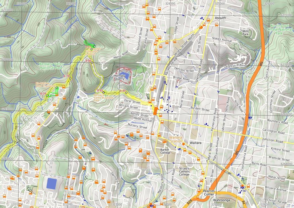
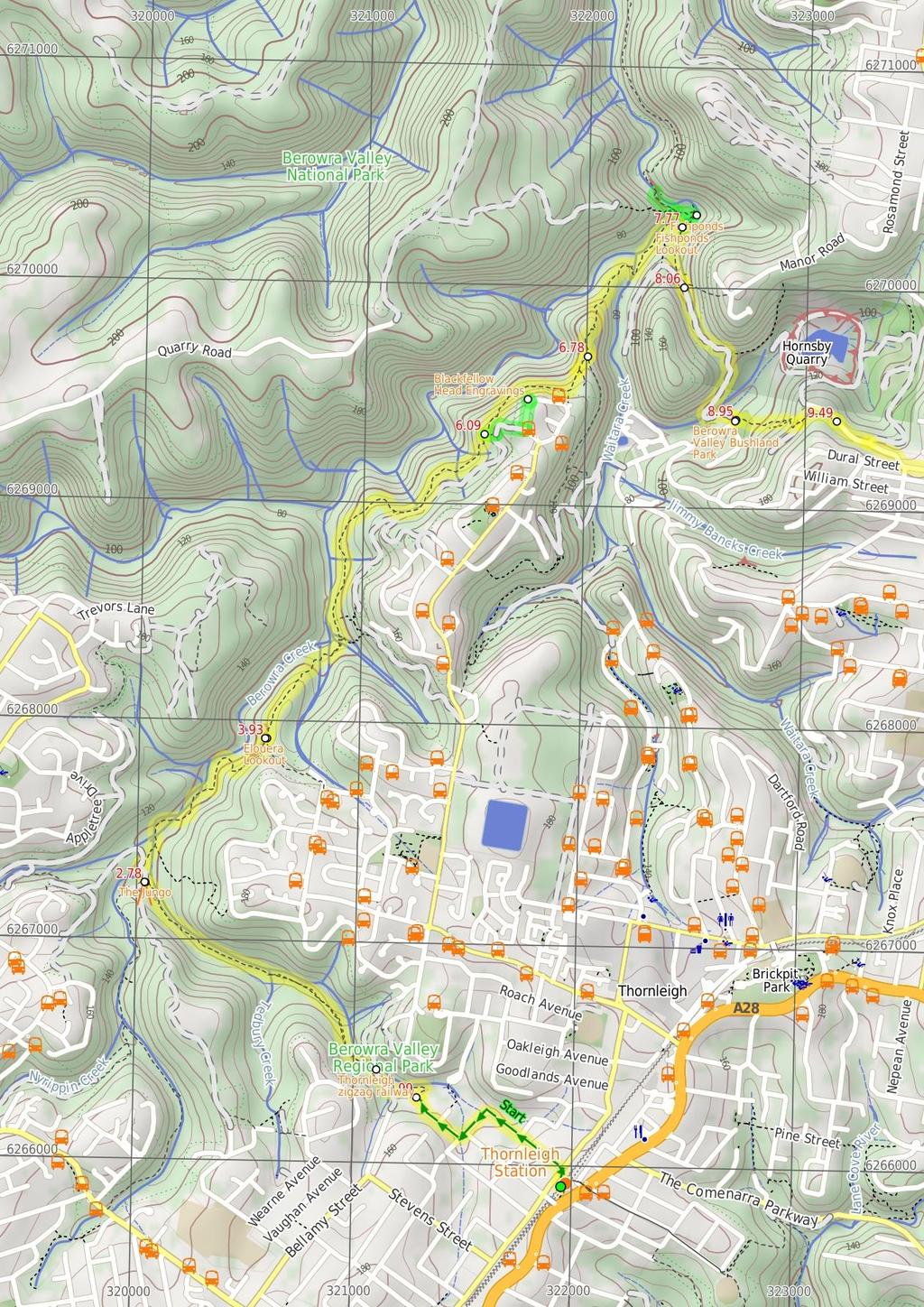
1 Thornleigh to Hornsby 4 hrs Hard track 10.2 km One way 4 526m Starting at Thornleigh station you walk through suburban streets for a short while before diving into the bush at the southern end of Berowra Valley Regional Park. Soon after visiting the site of the historic Zig Zag railway you start wandering through the Berowra Creek valley, passing a few cascading creeks. The track undulates along the side of the valley visiting a range of environments from moist fern forest to the drier grass tree and eucalypt forests of the ridge. There is a short side trip to visit the Westleigh engravings and a chance to pop down to fishponds, before climbing up the depression era stone steps to Hornsby station. 184m 49m Berowra Valley National Park Maps, text & images are copyright wildwalks.com Thanks to OSM, NASA and others for data used to generate some map layers.

2 Thornleigh zigzag railway Before You walk The Thornleigh zigzag railway originally ran from the main rail line near Thornleigh to an historic quarry, near present day De Saxe Cl, Thornleigh. There are only minor fragments still visible today. The 'Heritage Trail' in Thornleigh has interpretive signs for the railway and the old Thornleigh Quarry. A book is available with some detail on railway and associated quarry: 'Sydney's Forgotten Quarry Railways' by John Oakes, ISBN Bushwalking is fun and a wonderful way to enjoy our natural places. Sometimes things go bad, with a bit of planning you can increase your chance of having an ejoyable and safer walk. Before setting off on your walk check The Jungo The Jungo is a relatively small clearing and campsite near the junction of Berowra and ZigZag Creeks at a well signposted intersection. There is often water in the creeks (treat well before drinking) but there are no facilities. Speculation on the source of the name 'Jungo' includes the Aussie tendency to abbreviate words ('Junction' gets corrupted to 'jung-o' etc) as well as a possible derivation from one of a few similar sounding aboriginal words. Elouera Lookout This fenced lookout is on the Benowie Track close to Westleigh. There are uninterrupted views from the clifftop across the Berowra Creek valley, which is rare for the area. As well as being on the Great North Walk, this lookout can be accessed by a short walk from Elouera Rd, Westleigh. This section of fenced rock platform is about 100m long, and there is some limited shade from the casuarina near the lookout if you want to take a rest. Blackfellow Head Engravings On the far north west corner of Quarter Sessions Road (beside no.280), there is a lookout and some Aboriginal engravings. The signposted site has a timber platform providing some filtered views across the valley. On the left side of the platform is a sandstone block with the engraved images of two wallabies. There are reports of other engravings in the area, but like many similar sites, their exact locations are not published to protect them. Please keep off the engravings area, to reduce wear. Fishponds Lookout Fishponds Lookout is a fenced rock platform at the intersection of the Benowie walking track and the Rosemead trackhead. It is marked with a number of Great North Walk signs. This informally named lookout has good views down over Fishponds, a large waterhole on Berowra Creek. Looking north across the creek, there are views to the upper waterhole and the cliffs on the other side. 1) Weather Forecast (BOM Metropolitan District) 2) Fire Dangers (Greater Sydney Region) 3) Park Alerts (Berowra Valley National Park) 4) Research the walk to check your party has the skills, fitness and equipment required 5) Agree to stay as a group and not leave anyone to walk solo Think before you TREK The 'Think before you TREK' program developed by NSW Police & NPWS promotes the benefits of planning ahead for your bushwalking trip by using an easy to remember acronym: adequate supplies of food, water, navigation and first T Take aid equipment. your planned route and tell friends and family when R Register you expect to return. beacon (PLB's) should be carried on walks with E Emergency significant gaps in mobile coverage (check terrain profile). to your planned route and follow the map and walking K Keep trails. Topo Maps The maps provided on wildwalks are helpful, but there are times where you may need maps covering a broader area. Maps that cover this walk include; 1: Map Series:91304S HORNSBY 1: Map Series:9130 SYDNEY Grade This walk has been graded using the AS The overall grade of the walk is dertermined by the highest classification along the whole track. 4 Grade 4/6 Hard track Length 10.2 km One way Time 4 hrs Quality of track Formed track, with some branches and other obstacles (3/6) Signs Directional signs along the way (3/6) Experience Required Moderate level of bushwalking experience recommended (4/6) Weather Storms may impact on navigation and safety (3/6) Infrastructure Limited facilities, not all cliffs are fenced (3/6)
3 Are you ready to have fun? Please ensure you and your group are well prepared and equipped for all possible hazards and delays. Check park closures, weather information and Fire Danger Rating before setting out. Optional side trips and alternate routes noted are not included in this walks overall grade, length or time estimate. Please allow extra time for resting and exploring areas of interest. The authors, staff and owners of wildwalks take care in preparing this information but will not accept responsibility for any inconvenience, loss or injury you may experience. Please take care, have fun - Happy Walking. Getting there You can get to Thornleigh Train Station (gps: , ) by car, train or bus. Car: There is free parking available. You can get back from Hornsby Train Station (gps: , ) by car, train or bus. Car: There is free parking available. Find up to date and more information inlcuding; travel directions, weather, park closures and walker feedback at 0 Thornleigh Train Station (990 m 18 mins) From the western (north bound) side of Thornleigh Station, this walk follows the 'Jungo Rest Area' sign along the footpath towards the car park and The Esplanade. The walk then heads down a short distance further to turn left and cross 'The Esplanade' at the traffic lights, then continue straight along the footpath down along Eddy Rd. Following a couple of GNW arrows down Eddy Rd as it then bends left, turning into Tilock St, and shortly later this walk then turns right into Morgan St. Continuing down till just before the end of this street, this walk comes to an intersection marked with a GNW arrow and the 'Elouera Bushland Natural Park' sign (on the right) Morgan Rd (370 m 6 mins) Turn right: From the end of Morgan Street, the walk follows the GNW arrow and the 'Elouera Bushland Natural Park' sign between houses no. 28 and 26. Once behind the houses at a small clearing, the track turns left and follows down the rocky side of Zig Zag Creek. Soon after passing behind the third house, the track comes to an intersection with a wide concrete trail, where a sign points back along the track to 'Sydney Cove'. Turn right: From the intersection, this walk follows the 'The Jungo' sign downhill along the wide concreted trail, and soon crosses over the culverted creek (with green side rails). The walk continues down into the valley, coming to a signposted intersection marked with a 'Great North Walk' sign (on your left), just before Zig Zag Creek and the long bridge Thornleigh zigzag railway The Thornleigh zigzag railway originally ran from the main rail line near Thornleigh to an historic quarry, near present day De Saxe Cl, Thornleigh. There are only minor fragments still visible today. The 'Heritage Trail' in Thornleigh has interpretive signs for the railway and the old Thornleigh Quarry. A book is available with some detail on railway and associated quarry: 'Sydney's Forgotten Quarry Railways' by John Oakes, ISBN Zig Zag Creek Bridge intersection (1.4 km 25 mins) Turn left: From the intersection, this walk follows the 'Great North Walk' sign along the narrower track, keeping the gully to your right. The pleasant track leads into, then through, the ferny forest with tall trees for about 700m, before crossing a side creek on a timber bridge. The track then continues in a similar manner for another 700m, coming to a large clearing and campsite, The Jungo. On the far side of this clearing is a well-signposted intersection with a 'Bellamy Street' sign pointing back through the campsite The Jungo The Jungo is a relatively small clearing and campsite near the junction of Berowra and ZigZag Creeks at a well signposted intersection. There is often water in the creeks (treat well before drinking) but there are no facilities. Speculation on the source of the name 'Jungo' includes the Aussie tendency to abbreviate words ('Junction' gets corrupted to 'jung-o' etc) as well as a possible derivation from one of a few similar sounding aboriginal words Jungo campsite (1.1 km 29 mins) Veer right: From the campsite, this walk follows the 'Fishponds' sign down across the concrete ford, over the usually small creek. Here, the concrete management trail leads uphill, becoming dirt as it starts to flatten out. This walk then comes to a signposted intersection of the 'Great North Walk' and the Stringybark Ridge management trail (signposted 'Cherrybrook Lakes' trail). Turn right: From the intersection, this walk follows the 'Great North Walk' sign down the narrower track. The track leads downhill for about 70m, getting steeper as it goes, and then crosses Berowra Creek - this creek may become impassable after rain. On the other side, the walk comes to an intersection on a small sandy beach. Here, the walk turns left, following the GNW arrows downstream for about 250m among the grass trees and crossing a flat timber bridge. The rocky track then continues for just shy of 250m and crosses a mossy gully on a large flat rock. The track then continues, staying fairly flat for another 170m before bending right and heading steeply uphill. At the top of this climb, the track soon leads to a section of fenced cliff. At the end of the fence, the walk passes through casuarina forest for a short distance before passing alongside another (longer) fenced cliff and coming to the Elouera Lookout, where there is an intersection with the 'Westleigh' track (on your right) Elouera Lookout This fenced lookout is on the Benowie Track close to Westleigh. There are uninterrupted views from the clifftop across the Berowra Creek valley, which is rare for the area. As well as being on the Great North Walk, this lookout can be accessed by a short walk from Elouera Rd, Westleigh. This section of fenced rock platform is about 100m long, and there is some limited shade from the casuarina near the lookout if you want to take a rest Elouera Lookout (2.2 km 54 mins) Continue straight: From Elouera Lookout, this walk follows the 'Great North Walk' sign along the track, keeping the fence and valley to your left. At the end of the fence, the walk bends left following the rocky flat track for about 200m, where the track then becomes progressively steeper for about 250m, winding steeply down then across a flat timber bridge. From here, the track leads beside Berowra Creek for a short time before crossing another flat timber bridge. The track then passes among the pleasant grass trees for about 200m (crossing a couple of small creeks with timber plank spans) to then climb a few sets of timber steps and cross a small (often dry) creek. From here, the track gently winds up along the side of the hill for about 800m, passing through a pleasant casuarina forest then heading across a rocky creek on another small, flat, timber bridge. Just over 100m later, the track crosses a smaller (often dry) creek to then wind uphill for about 100m to a three-way intersection with the signposted 'Quarter Sessions Rd' track (on your right) Optional sidetrip to Blackfellow Head Engravings (370 m 10 mins) Veer right: From the intersection, this walk follows the 'Quarter Sessions Rd' sign directly uphill along the faint track, up over the rocky outcrop, with the occasional rock step. After about 50m, this track leads to a T-intersection with a wide management trail. Turn left: From the intersection, this walk follows the management trail uphill. The trail soon bends right and after about 90m (ignoring side tracks), the walk heads around a locked gate. Here the walk follows the grassy (and rocky) trail between two houses to an intersection with Quarter Sessions Rd (between 394 & 396). Turn left : From the intersection, this walk follows Quarter Sessions Road uphill. The road passes over the rise and, after 130m, comes to a point where the road bends right, just beside a 'Berowra Valley Regional Park' sign (on your left). Turn left: From beside 280 Quarter Sessions Road (Westleigh), this walk heads towards the 'Berowra Valley Regional Park' sign, over the grass towards the timber platform. The walk steps onto the timber platform (with a handrail) to find a filtered valley view (to your right) and the engravings in the sandstone (to your left). At the end of this side trip, retrace your steps back to the main walk then Turn right Blackfellow Head Engravings On the far north west corner of Quarter Sessions Road (beside no.280), there is a lookout and some Aboriginal engravings. The signposted site has a timber platform providing some filtered views across the valley. On the left side of the platform is a sandstone block with the engraved images of two wallabies. There are reports of other engravings in the area, but like many similar sites, their exact locations are not published to protect them. Please keep off the engravings area, to reduce wear Int of the GNW and the Quarter Sessions Road track (690 m 18 mins) Veer left: From the intersection, this walk heads north along the main rocky track, keeping the valley down to your left. The track leads along beside a rock wall (which is on your right) and through a rock outcrop, where the track soon heads quite steeply uphill along the eroded track for a short time. At the top of this steep section, the rocky track continues to meander much more gently up along the side of the hill for about 300m, then crosses a small, rocky gully, just below some houses. The track then continues gently uphill for about 100m to an intersection with the unsignposted Blackfellows Head track (on your right). Continue straight: From the intersection, this walk heads north along the clear track, keeping the valley down to your left for about 100m, where the walk comes to a three-way intersection and 'The Jungo' sign points back along the track Int of the GNW and the Blue Gum Walk (SW) (990 m 21 mins) Veer left: From the intersection, this walk follows the 'Fishponds' sign past the 'Berowra Valley Regional Park' sign, gently uphill along the narrow ridge. The track is mostly flat for about 200m before it starts to head fairly steeply down over some rocks and down a set of rock steps. This area comes alive with Patersonia lilies and pink wax flowers in early spring. The track then continues fairly gently down along the narrow ridge for another 200m before leading through a crack in a rock, then down a bit further to climb down through a particularly steep rocky section. Near the bottom of this descent, this walk passes a couple of arrow posts, where the track bends right to pass below a large rock overhang. Just beyond this overhang, the track bends left and leads across Waitara Creek at the interesting holes in the rock know as 'the spa'. This creek may become impassable after heavy rain, the rocks can also be slippery. Across the creek, the walk comes to a large rock platform and a Blue Gum Track post. After stopping to enjoy cool spot, this walk continues left along the unfenced rock platform (keeping the creek down to your left). The walk soon steps off this large rock (at the far right-hand corner, through the fork in a tree). This walk heads over another rock platform, then along a notably flat section of track (now with Berowra Creek on your left), passing beside some cascades for about 100m before climbing up and over some rocks and under a sandstone overhang. The track leads around the side of the hill for about 100m, then down to cross a small creek using the small flat timber bridge. The walk then

4 climbs up some timber steps to a fenced lookout over Fishponds, at a wellsignposted intersection. A sign points back along the track to 'Thornleigh Station' Fishponds Lookout Fishponds Lookout is a fenced rock platform at the intersection of the Benowie walking track and the Rosemead trackhead. It is marked with a number of Great North Walk signs. This informally named lookout has good views down over Fishponds, a large waterhole on Berowra Creek. Looking north across the creek, there are views to the upper waterhole and the cliffs on the other side Optional sidetrip to Fishponds Bridge (350 m 8 mins) Continue straight: From the lookout, this walk follows the 'Galston Gorge' sign along the fenced rock shelf (keeping the fence to your left). The track leads down the rocky steps to the edge of Berowra Creek. The walk crosses the creek using the stepping stones, and comes to a small cave on the other side. This creek may be impassable after rain. Veer right: From the cave, this walk follows the 'Galston Gorge' sign up the track and timbers steps. Soon the track turns left and follows a Great North Walk arrow up the hill, at the red and white 'Danger' sign(ignoring the other track). The track climbs up the carved steps onto the rock platform and continues up the rocky track until just after passing through a narrow gap between two rocks, where this walk comes to the un-signposted (and faint) intersection with the Pogson's Trig track (on the left). Continue straight: From the intersection, this walk heads down along the side of the hill, whilst keeping the main valley to your right. The track leads down some rocky steps, passing just above a rock platform (a short distance down on your right, with a plaque dedicated to 'Cora'). The track then leads down along the base of a cliff, passing under a rock overhang. The track continues along the base of the cliff for another 50m then starts to wind downhill (with some handrails) to come to a rock platform beside the creek. This walk then crosses Berowra Creek on the flat timber bridge. At the end of this side trip, retrace your steps back to the main walk then Turn left Fishponds Fishponds is a long waterhole on Berowra Creek in Berowra Valley Regional Park. The waterhole is lined with tall cliffs and a few sandstone caves. At the southern end, there are stepping stones to help cross the creek, and a small timber bridge at the northern end. This is a beautiful spot and a worthy place to rest and enjoy the water passing by. The waterhole is fairly popular with local teens in summer, cooling off. Swimming and jumping at the Fishponds waterhole has resulted in fatalities - please heed the signs and Cora's parents' plea and enjoy the water from the edge Fishponds Lookout (300 m 7 mins) Turn right: From the lookout, this walk follows the 'Rosemead Rd Trackhead' sign directly away from the view over Berowra Creek. After about 70m, the track leads over a timber footbridge, then leads up the side of the valley for about 100m to climb up the steep carved rock steps (with a hand rail). Here the track leads along the top of this unfenced cliff and soon comes to a well signposted three-way intersection, where a 'Fishponds' sign points back along the track. Continue straight: From the intersection, the walk follows the 'Hornsby Station' sign up along the track a short distance to come to an intersection with a wide management trail Int of Blue Gum Walk and Joes Mountain Service Tra (890 m 20 mins) Veer left: From the intersection, this walk follows the Great North Walk arrow south along the wide management trail, keeping the gully to your left. The walk climbs up the gentle hill for just over 300m, passing through the turpentine forest to a saddle and small clearing. Here the walk continues along the trail as it bends right (ignoring the track to the left) to leads downhill through the blue gum and bracken fern forest. The trail continues moderately steeply down until it bends left to cross Old Mans Creek at the concrete stepping stones. The trail leads left and gently up the hill, passing some houses (on your right) and soon comes to an intersection with a narrower track (on your left) after about 150m. Veer left: From the intersection, this walk follows the Great North Walk arrow along the narrower track for a short distance, to Berowra Valley Bushland Park at the end of Rosemead Road Berowra Valley Bushland Park 'Berowra Valley Bushland Park' is also known as Rosemead Rd Park and is found at the bottom end of Rosemead Rd, Hornsby. This is an open area park surrounded by shady eucalyptus trees, making a pleasant spot to rest on a walk. It has a picnic table with bench seats, and a sheltered free electric BBQ. There is a water tap in the park, near the road. There is also a 'Welcome to Old Mans Valley' information sign with information about the traditional country of the Darug and Guringai peoples Berowra Valley Bushland Park (540 m 14 mins) Veer left: From the lower side of 'Berowra Valley Bushland Park', this walk follows the 'Hornsby Station' sign across the park, then follows the GNW arrow up the stone steps, keeping the houses to your right. The walk winds steeply up the steps, leaving the view of the house and finding a welcome flat section of track midway up. The steps then lead more steeply up the side of the valley, along the sheer rock walls for about 100m, and come to an intersection with the Quarry Road management trail, where a 'Great North Walk' sign points back down the the hill. Continue straight: From the intersection, this walk follows the GNW arrow post up a couple of timber steps and then follows the track as it winds up over the gentle rise. Once over the rise, the track then leads down to the intersection with Quarry Rd, where a 'Great North Walk' sign points back up the track Int of Quarry Road and GNW (720 m 14 mins) Turn right: From the intersection, this walk follows Quarry Road gently uphill away from the face of the 'Great North Walk' sign until just past a couple of house, this walk comes to an intersection with the gated 'Old Mans Valley' management trail (on your left). Continue straight: From the intersection, this walk follows Quarry Rd up the gentle hill for about 180m, then follows the GNW arrow left onto Dural St. The footpath leads past the unit block, then past a few shops to come to an intersection with the Pacific Hwy. Following the GNW arrow, this walk turns right across 'Dural St', passes a few more shops, then crosses 'Dural Lane' before turning left across the Pacific Hwy at the traffic lights. Here the walk continues straight across the 'Station St' pedestrian crossing, past the large 'Great North Walk' sign and across the bus lane to the western entrance of Hornsby Station.
5
6
7 Summary navigation sheet for the Thornleigh to Hornsby km From Start Thornleigh Train Station , (GR Hornsby, ) 0.99 Morgan Rd , (GR Hornsby, ) 1.36 Zig Zag Creek Bridge intersection , (GR Hornsby, ) 2.78 Jungo campsite , (GR Hornsby, ) 3.93 Elouera Lookout , (GR Hornsby, ) 6.09 Int of GNW and the Quarter Sessions Rd track , (GR Hornsby, ) m 18 mins 370 m 6 mins 1.4 km 25 mins 1.1 km 29 mins 2.2 km 54 mins 370 m 10 mins From the western (north bound) side of Thornleigh Station, this walk follows the 'Jungo Rest Area' sign along the footpath towards the car park and The Esplanade. Turn right: From the end of Morgan Street, the walk follows the GNW arrow and the 'Elouera Bushland Natural Park' sign between houses no. Turn left: From the intersection, this walk follows the 'Great North Walk' sign along the narrower track, keeping the gully to your right. Veer right: From the campsite, this walk follows the 'Fishponds' sign down across the concrete ford, over the usually small creek. Continue straight: From Elouera Lookout, this walk follows the 'Great North Walk' sign along the track, keeping the fence and valley to your left. Optional sidetrip to Blackfellow Head Engravings. Veer right: From the intersection, this walk follows the 'Quarter Sessions Rd' sign directly uphill along the faint track, up over the rocky outcrop, with the occasional rock step Int of the Great North Walk and the Quarter Sessions Road track , (GR Hornsby, ) m 18 mins Veer left: From the intersection, this walk heads north along the main rocky track, keeping the valley down to your left Int of the Great North Walk and the Blue Gum Walk (SW) , (GR Hornsby, ) m 21 mins Veer left: From the intersection, this walk follows the 'Fishponds' sign past the 'Berowra Valley Regional Park' sign, gently uphill along the narrow ridge Fishponds Lookout , (GR Hornsby, ) Fishponds Lookout , (GR Hornsby, ) Int of Blue Gum Walk and Joes Mountain Service Trail , (GR Hornsby, ) m 8 mins 300 m 7 mins 890 m 20 mins Optional sidetrip to Fishponds Bridge. Continue straight: From the lookout, this walk follows the 'Galston Gorge' sign along the fenced rock shelf (keeping the fence to your left). Turn right: From the lookout, this walk follows the 'Rosemead Rd Trackhead' sign directly away from the view over Berowra Creek. Veer left: From the intersection, this walk follows the Great North Walk arrow south along the wide management trail, keeping the gully to your left. Berowra Valley Bushland Park , (GR Hornsby, ) Int of Quarry Road and Great North Walk , (GR Hornsby, ) m 14 mins 720 m 14 mins Veer left: From the lower side of 'Berowra Valley Bushland Park', this walk follows the 'Hornsby Station' sign across the park, then follows the GNW arrow up the stone steps, keeping the houses to your right. Turn right: From the intersection, this walk follows Quarry Road gently uphill away from the face of the 'Great North Walk' sign until just past a couple of house, this walk comes to an intersection with the gated ' Powered by TCPDF ( Up/Dwn Length Initial directions (Use full tracknotes and maps for more detail)
Hornsby Blue Gum Walk
 Hornsby Blue Gum Walk 3 hrs Hard track 6.7 km Circuit 4 374m This delightful loop is one of the prettiest and most popular walks in the Hornsby area. Going from an environment of ferns and clear bushland
Callicoma Loop. 174m. 98m. 2 hrs. Hard track 5.1 km Circuit. 153m
 Callicoma Loop 2 hrs Hard track 5.1 km Circuit 153m This great circuit walk passes through some really nice forest around the fringe of Cherrybrook. Highlights of the walk include some beautiful rock overhangs
Hunters Hill to Epping Road
 Hunters Hill to Epping Road 2 hrs 30 mins 5.5 km One way Moderate track 154m An enjoyable walk through lower sections of the Lane Cove National Park, this walk features plenty of mangroves next to the
Sid Pulsford Walk. 175m. 33m. 1 hr 45 mins 4.1 km One way. Hard track 118m. Gosford LGA
 Sid Pulsford Walk 1 hr 5 mins.1 km One way Hard track 118m Sid Pulsford Walk explores the ridge top of Kincumber Mountain, from Honeman's Rock to Green Point. The walk mostly follows wide management trails.
Wentworth Falls Conservation Hut Loop
 Wentworth Falls Conservation Hut Loop 3 hrs Hard track 6.7 km Circuit 4 341m This scenic walk from Wentworth Falls Station, winds along the Nature Trail to Conservation Hut, then drops into the magnificent
Epping to Pennant Hills Station (via Lane Cove River)
") Epping to Pennant Hills Station (via Lane Cove River) 3 hrs 5 mins 8.4 km One way Hard track 249m This walk, from Epping to Pennant Hills Station, is a great way to see the upper Lane Cove River Valley.
Epping to Pennant Hills Station (via Lane Cove River) 3 hrs 5 mins 8.4 km One way Hard track 249m This walk, from Epping to Pennant Hills Station, is a great way to see the upper Lane Cove River Valley.
Currie Rd to Davidson Park
 Currie Rd to Davidson Park 3 hrs 7.2 km One way Moderate track 28m Starting at Currie Rd in Forestville, this walk follows Middle Harbour to Davidson Park, under Roseville Bridge. There are two optional
De Burgs Bridge to Thornleigh station
 De Burgs Bridge to Thornleigh station 3 hrs 45 mins 9.7 km One way Hard track 4 363m This walk follows a section of the Great North Walk, starting from De Burghs bridge. The walk winds north west, through
Echo Point to Leura Forest via Three Sisters and Giant Stairs loop
 Echo Point to Leura Forest via Three Sisters and Giant Stairs loop 3 hrs 3.8 km Circuit Hard track 512m This walk starts from the popular Echo Point, in Katoomba, and winds down to the base of the Three
Epping to Eastwood Station (via Lane Cove River)
") Epping to Eastwood Station (via Lane Cove River) hrs 45 mins 10.2 km One way Moderate track 189m Epping to Eastwood, via Lane Cove River, is the longer route through the bush between the stations. This
Epping to Eastwood Station (via Lane Cove River) hrs 45 mins 10.2 km One way Moderate track 189m Epping to Eastwood, via Lane Cove River, is the longer route through the bush between the stations. This
Sphinx, Warrimoo and Bobbin Head tracks
 Sphinx, Warrimoo and Bobbin Head tracks 4 hrs 9.6 km Circuit Moderate track 499m This great walk starts at the Sphinx Memorial and loops around via Cowan Creek, exploring diverse environments as it changes
Carrington Park to Leura Forest and pass loop
 Carrington Park to Leura Forest and pass loop 3 hrs Hard track 4.8 km Circuit 4 674m This walk is a fantastic way to see Leura Forest. The walk descends from Carrington Park, visiting Leura Forest and
Popes Glen, Pulpit Rock, Govetts Leap and Braeside Walk
 Popes Glen, Pulpit Rock, Govetts Leap and Braeside Walk 8 hrs Hard track 13.6 km Circuit 4 1068m This large circuit walk, from Popes Glen to Pulpit Rock, Govetts leap and along the Braeside Track, passes
Wattamolla to Big Marley Beach
 Wattamolla to Big Marley Beach 4 hrs 10.4 km Circuit Moderate track 4m This walk is an excellent loop which takes in both the coast and the heathy inland of Royal National Park. Nearly the whole walk has
Govetts Leap Loop. 1065m. 909m Blue Mountains National Park. 4 hrs 30 mins 8.7 km Circuit. Hard track 380m
 Govetts Leap Loop 4 hrs 30 mins 8.7 km Circuit Hard track 380m This walk, from Blackheath Train Station, is a fantastic way to see some of the iconic areas of the Blue Mountains in the Blackheath area.
Campbell Drive to Snapper Point
 Campbell Drive to Snapper Point 1 hr 45 mins 4.2 km One way Experienced only 135m This walk follows the Coast Track to Frazer Beach, along the Geebung and (overgrown) Grass Tree Tracks. From the northern
Morgans Creek to Padstow
 Morgans Creek to Padstow 2 hrs 45 mins 8 km One way Moderate track 3 144m This pleasant walk starts from the Morgans Creek park, at Henry Lawsons Drive, and follows the Georges River past the Boomerang
Berowra to Mt Kuring-gai
 Berowra to Mt Kuring-gai 4 hrs 30 mins 9.4 km One way Hard track 4 551m From the ridges above Cowan Creek, this walk takes in some great lookouts (especially around Mt Kuringgai) as well as enjoying an
Waterfall to Heathcote
 Waterfall to Heathcote 5 hrs Hard track 10.8 km One way 4 467m This walk explores the heart of Heathcote National Park, and is easily accessed with a train station at either end. Although relatively close
Heathcote to Engadine via Audley
 Heathcote to Engadine via Audley 6 hrs 3 mins 5 km One way Hard track 4 635m Covering a large section of central Royal National Park, this walk goes through the heath and scrub along a well managed and
Little Digger Track. 68m. 1 Hr 2.2 km One way. Moderate track 93m. Moores Creek Reserve
 Little Digger Track Hr 2.2 km One way Moderate track 93m This walk follows Moores Creek through several reserves in east Roseville and East Lindfield. The track is named after Australia's 7th Prime Minster,
The Foreshore Walk. 24m. 1m Lake Macquarie LGA. 1 hr 15 mins 2.9 km One way. Hard track 81m
 The Foreshore Walk 1 hr 15 mins 2.9 km One way Hard track 81m This walk traverses the coastline of the Green Point reserve. By following a variety of tracks and occasionally traveling inland through eucalyptus
Little Digger Track to Davidson Reserve and Lyrebird Circuit
 Little Digger Track to Davidson Reserve and Lyrebird Circuit 4 hrs 3 mins 11.5 km One way Hard track 4 47m Exploring both the eastern and western sides of Middle Harbour Creek, this walk follows the Little
Teralba to Charlestown Park track head
 Teralba to Charlestown Park track head 4 hrs 30 mins 13.3 km One way Moderate track 3 220m This section of the Great North Walk starts from the Teralba train station and winds down and around the edge
De Burghs Bridge to Fullers Bridge
 De Burghs Bridge to Fullers Bridge 2 hrs 3 mins Hard track 6 km One way 2m 4 Following the Lane Cove River, this walk mostly follows a section of the Great North Walk and is well maintained and signposted.
Katoomba Falls Circuit
 Katoomba Falls Circuit hr 5 mins.5 km Circuit Hard track 59m For those looking for a walk involving more than simple boardwalk, this trail winding through the temperate rain forest could be just the thing.
Wallarah Coastal Walk
 Wallarah Coastal Walk 3 hrs 8.3 km Return Hard track 247m This walk starts at Caves Beach and travels south along the coastline, until reaching the Pinney s Headland Lookout. There are many opportunities
Patonga to Woy Woy. 5 hrs 45 mins 15.5 km One way. Hard track. 497m
 Patonga to Woy Woy 5 hrs 45 mins 15.5 km One way Hard track 4 497m This walk explores a variety of environments from the shore line and coastal cliffs near Patonga, to the dry, rocky and open ridge line.
Rail to River Walk. 3 hrs. Hard track 7.5 km Circuit. 222m
 Rail to River Walk 3 hrs Hard track 7.5 km Circuit 4 222m This walk is a great one from Chatswood Station to the Lane Cove River National Park. The walk descends through the vegetated bushland which fills
Dead Horse Gap Loop track
 Dead Horse Gap Loop track 4 hrs 30 mins Hard track 9.8 km Circuit 144m 4 This walk starts with a ride up the Kosciuszko Express Chairlift. There is an opportunity to eat at Australia's highest restaurant,
Middle Harbour Creek Loop
 Middle Harbour Creek Loop 5 hrs 45 mins 15.1 km Circuit Experienced only 5 570m This walk explores the upper reaches of Middle Harbour Creek, starting and ending at the great parklands at Davidson Park,
Mackerel Beach, West Head Loop
 Mackerel Beach, West Head Loop 5 hrs 8.6 km Circuit Hard track 422m The Mackerel Beach, West Head Loop is a walk which explores a large part of the West Head. The journey starts and finishes with a ferry
Scenic World to Echo Point
 Scenic World to Echo Point 1 hr 15 mins 2.1 km One way Moderate track 192m This is one of the most popular tourist walks in the Katoomba area. The walk follows the cliffs along a well maintained and signposted
Under and Over Cliff Walk
 Under and Over Cliff Walk 4 hrs 9.4 km Circuit Moderate track 576m This walk from Wentworth Falls Station is a fantastic way to see a large majority of the Wentworth Falls cliffline. The track winds under
National Pass from Wentworth Falls to Conservation Hut
 National Pass from Wentworth Falls to Conservation Hut 3 hrs Hard track 3.6 km One way 739m Starting at Wentworth Falls picnic area, this scenic and historic walk explores many waterfalls, lookouts and
Rail to River and Stringybark Creek Reserve Walk
 Rail to River and Stringybark Creek Reserve Walk 4 hrs Hard track 11.2 km Circuit 4 302m This walk begins in the busy city of Chatswood and soon enters the nearby bushland around the Lane Cove River. The
Roseville to Macquarie Park
 Roseville to Macquarie Park 3 hrs 3 mins 8.8 km One way Hard track 4 29m This walk starts at Roseville station and explores the streets and alleyways of Roseville before joining the main spine of the Great
The Basin Track and Mackerel Track
 The Basin Track and Mackerel Track 3 hrs 5.9 km Circuit Hard track 226m This walk is a great way to see some popular areas in Ku-ring-gai Chase National Park. The walk from West Head Rd travels to The
Epping to Gordon Station
 Epping to Gordon Station 4 hrs 15 mins 11.7 km One way Hard track 4 365m This walk, from Epping Station to Gordon Station, passes below the homes which sit on the hills high above the Lane Cove River.
Green Point Circuit Walk
 Green Point Circuit Walk 3 hrs 7.7 km Circuit Hard track 269m This walk visits all of the popular locations in Green Point Reserve, as well as some of the lesser-visited areas inland. Taking in Sea Eagle
Wentworth Falls Station Loop (Undercliff Walk)
") Wentworth Falls Station Loop (Undercliff Walk) 4 hrs 3 mins Hard track 8.9 km Circuit 658m 4 This walk passes some stunning waterfalls and views into the Jamison Valley, following the cliff edges around
Wentworth Falls Station Loop (Undercliff Walk) 4 hrs 3 mins Hard track 8.9 km Circuit 658m 4 This walk passes some stunning waterfalls and views into the Jamison Valley, following the cliff edges around
Mackerel Beach and Resolute Loop
 Mackerel Beach and Resolute Loop 3 hrs 5.4 km Circuit Hard track 384m This walk is another great walk in Ku-ring-gai Chase National Park, accessed by ferry. From the Mackerel Beach wharf, this walk uses
Woolwich Wharf to Boronia Park
 Woolwich Wharf to Boronia Park 2 hrs 5.8 km One way Moderate track 175m Going through the streets of Hunters Hill, this walk is on the first segment of the Great North Walk. The majority of the walk is
Blackheath Station to Junction Rock Loop (via Grand Canyon and Popes
 Blackheath Station to Junction Rock Loop (via Grand Canyon and Popes 8 hrs 30 mins 18.2 km Circuit Hard track 4 1254m This circuit starts in Blackheath and heads down into the Grand Canyon and Rodriguez
Federal Pass Walking Track
 Federal Pass Walking Track 5 hrs Hard track 8 km One way 4 989m This classic trail follows along the base of the cliffs from Leura to the Golden Stairs, passing many of the more popular sights of the Katoomba
Sphinx to Mt Kuring-gai
 Sphinx to Mt Kuring-gai 4 hrs 45 mins 1.7 km One way Hard track 673m This walk starts at the Sphinx War Memorial and follows some well maintained and popular walking tracks down to Cowan Creek. Enjoy the
Balmoral Beach to The Spit
 Balmoral Beach to The Spit 2 hrs 30 mins.3 km One way Hard track 85m This walks follows the coast from Balmoral to the Spit and across Spit Bridge. There are some alternate tracks to consider at high-tides,
Dubbo Gully and Ten Mile Hollow Circuit (via Clares Bridge)
") Dubbo Gully and Ten Mile Hollow Circuit (via Clares Bridge) 2 Days Hard track 24.3 km Circuit 4 1117m This two day (or ten hour) walk follows several historic roads, now closed to traffic. Starting with
Dubbo Gully and Ten Mile Hollow Circuit (via Clares Bridge) 2 Days Hard track 24.3 km Circuit 4 1117m This two day (or ten hour) walk follows several historic roads, now closed to traffic. Starting with
Upper Rumbalara circuit
 Upper Rumbalara circuit 1 hr 30 mins 3.3 km Circuit Hard track 176m A great circuit walk, covering most of the walking tracks and sights in the upper section of the Rumbalara Reserve. There is some really
Glenbrook and Euroka Circuit
 Glenbrook and Euroka Circuit 2 Days 16.6 km Circuit Experienced only 790m This two day circuit, returning to Glenbrook Station, is a scenic walk which passes many of the tourist attractions within the
Gordon to Chatswood Station
 Gordon to Chatswood Station 4 hrs 30 mins 12.2 km One way Hard track 4 381m This walk is a great way to get into the bush without being far from civilisation. The walk wanders through untouched valleys
Lane Cove Tourist Park River Circuit
 Lane Cove Tourist Park River Circuit 5 hrs 12 km Circuit Hard track 383m This walk follows a large section of Lane Cove River. The walk follows the Riverside Walking track up the Lane Cove River to De
Wentworth Falls Station Loop
 Wentworth Falls Station Loop 5 hrs 3 mins 9.5 km Circuit Hard track 4 13m The Wentworth Falls Station Loop takes in most of the upper tracks around Wentworth Falls. There are many scenic views near the
Gosford to Lisarow. 202m
 Gosford to Lisarow 4 hrs 3 mins Hard track 11.3 km One way 4 479m This walk is a great way to explore the ridge-top bushland between Gosford and Lisarow. Passing through Rumbalara and Katandra Reserves,
Wentworth Falls Loop. 893m. 665m. 6 hrs 10.2 km Circuit. Hard track 1093m. Blue Mountains National Park
 Wentworth Falls Loop 6 hrs 1.2 km Circuit Hard track 193m This is a great walk, both in size and spectacular views. The walk makes its way from Wentworth Falls train station and drops off the plateau,
Echo Point to Leura Forest Circuit
 Echo Point to Leura Forest Circuit 3 hrs 4.8 km Circuit Hard track 588m Forming a circuit around the cliffs and then the valley floor, this is a walk more then capable of convincing a walker of the beauty
Bouddi Coastal Walk. 5 hrs. Hard track 8.1 km One way. 364m
 Bouddi Coastal Walk 5 hrs Hard track 8.1 km One way 4 364m This is one of the longer walks in the Bouddi National Park and it is rich in scenery. The walk follows the coastline with many side trips to
Bobbin Head Loop. 166m. 0m Ku-ring-gai Chase National Park. 5 hrs 12.9 km Circuit. Hard track 619m
 Bobbin Head Loop 5 hrs 12.9 km Circuit Hard track 619m This great circuit walk enjoys a variety of landscapes in Ku-ring-gai Chase National Park. The walk starts at the historic Sphinx war memorial and
Taronga Wharf to Chowder Bay
 Taronga Wharf to Chowder Bay 2 hrs 4.4 km One way Moderate track 246m Starting at Taronga Wharf, this walk passes many icons of Sydney, including Taronga Zoo, HMAS Sydney Mast, Chowder Bay. The walk also
Spit Bridge to Middle Head Forts
 Spit Bridge to Middle Head Forts 2 hrs 30 mins 6.3 km One way Hard track 4 181m This scenic walk takes you from the Spit Bridge, along the coast to explore the Middle Head Forts. There are a few alternate
North Ryde Fairyland circuit
 North Ryde Fairyland circuit 2 hrs 30 mins Hard track 6.9 km Circuit 193m 4 Starting at North Ryde train station this walk explores a stretch of the Lane Cove River, visiting the historic Fairlylands Pleasure
Faulconbridge to Blaxland
 Faulconbridge to Blaxland 2 Days Experienced only 15.2 km One way 5 693m This two-day walk, or very solid one-day walk, takes you from station to station, through lush, scenic forest in the lower Blue
Hermitage Foreshore Track
 Hermitage Foreshore Track 1 Hr 2.2 km One way Moderate track 123m The Hermitage Foreshore Walk is a wonderful way to explore Sydney Harbour from the perspective of South Head. This walk starts from Nielsen
Chatswood to Epping Station
 Chatswood to Epping Station 6 hrs Hard track 16.3 km One way 4 533m This walk, from Chatswood to Epping, is a long but enjoyable walk along the Lane Cove valley. The walk mostly follows the Lane Cove River
Rumbalara Explorer. 158m. 5m Rumbalara Reserve. 2 hrs 45 mins 6.1 km Circuit. Hard track 326m
 Rumbalara Explorer 2 hrs 5 mins 6.1 km Circuit Hard track 326m Pretty well the grand tour of the Rumbalara Reserve, this walk takes in much of the great scenery the reserve has to offer. The walk covers
Charlestown Park trackhead to Newcastle station
 Charlestown Park trackhead to Newcastle station 5 hrs 30 mins 12.1 km One way Hard track 4 287m This section of the Great North Walk starts from the Charleston Park track head and winds through the streets
Scenic world to Three Sisters Loop via Furber Steps
 Scenic world to Three Sisters Loop via Furber Steps 5 hrs 5.8 km Circuit Hard track 722m This walk starts from the popular Scenic World, in Katoomba, and winds down the Furber steps into the Jamison Valley,
Spit Bridge to Manly (Manly Scenic Walkway)
") Spit Bridge to Manly (Manly Scenic Walkway) 3 hrs 45 mins 9.1 km One way Moderate track 349m The Spit to Manly walk is a classic bushwalk on Sydney's Northern Beaches. The walk follows a well-maintained
Spit Bridge to Manly (Manly Scenic Walkway) 3 hrs 45 mins 9.1 km One way Moderate track 349m The Spit to Manly walk is a classic bushwalk on Sydney's Northern Beaches. The walk follows a well-maintained
Narrabeen Lagoon Trail (from Middle Creek)
") Narrabeen Lagoon Trail (from Middle Creek) 2 hrs 30 mins 8.6 km Circuit Very easy 1 105m The Narrabeen Lagoon Trail is a wonderful and accessible walk on the Northern Beaches of Sydney. The trail is used
Narrabeen Lagoon Trail (from Middle Creek) 2 hrs 30 mins 8.6 km Circuit Very easy 1 105m The Narrabeen Lagoon Trail is a wonderful and accessible walk on the Northern Beaches of Sydney. The trail is used
The Coast Track. 2 Days. Hard track 27.4 km One way. 1351m
 The Coast Track 2 Days Hard track 27.4 km One way 4 1351m Heading south, this walk covers the coastline of the Royal National Park and can truly only be described as amazing. With breathtaking coastal
Six Foot Track. 1212m
 Six Foot Track 3 Days 44.8 km One way Hard track 4 2066m This classic walk takes you from Katoomba to Jenolan Caves via a historic horse route. The walk travels mainly along well-maintained service tracks
Cape Banks Circuit. 50m. 2m Botany Bay National Park. 3 hrs 7.3 km Circuit. Hard track 190m
 Cape Banks Circuit 3 hrs 7.3 km Circuit Hard track 19m This Cape Banks Circuit has a lot to offer and is thoroughly recommended. The walking travels over beaches, through coastal forest and across exposed
Bouddi Ridge and Coastal Walk
 Bouddi Ridge and Coastal Walk 2 Days Hard track 27 km Circuit 4 126m This overnight walk takes in the majority of the magnificent Bouddi National Park. The walk starts from the pleasant Putty Beach camping
Manly to Seaforth Oval
 Manly to Seaforth Oval 5 hrs 45 mins 13.7 km One way Moderate track 3 624m This walk follows the Manly to Spit Scenic Walkway, then continues past The Spit Bridge to Seaforth Oval. The walk provides magnificent
Sydney to Thornleigh via Lane Cove Tourist Park
 Sydney to Thornleigh via Lane Cove Tourist Park 2 Days 33 km One way Hard track 4 1114m This overnight walk starts from the Obelisk in Macquarie Park, Sydney, at the official start of the Great North Walk.
Taronga Zoo to Spit Bridge
 Taronga Zoo to Spit Bridge 5 hrs Hard track 1.4 km One way 4 41m This is a scenic and culturally rich walk with views over Sydney Harbour and many interesting heritage buildings along the way. The start
Light to Light Walk 2 days
 Light to Light Walk 2 days 2 Days Hard track 3.9 km One way 4 794m Over two days, this classic walk explores the coast from Boyd Tower to the Green Cape Lighthouse in the south. Hegartys Bay Camp is over
Tideswell to Castleton
 Tideswell to Castleton 1 Walk summary Length: 14 km, 8.5 miles Maps: OS Explorer OL1 The Peak District - Dark Peak Area, OS Explorer OL24 The Peak District - White Peak Area, OS Landranger 110 Sheffield
THE WELLDIGGERS ARMS, HESWORTH AND FITTLEWORTH TRAIL
 THE WELLDIGGERS ARMS, HESWORTH AND FITTLEWORTH TRAIL 5.5 miles Circular 3 hours 041017 Challenging Terrain A 300-year-old pub turned country-inn on the edge of the South Downs National Park, The Welldiggers
Masson Hill. Walk. Approximately 4 km. Moderate Walk Begins from Matlock Railway Station
 Masson Hill Walk Approximately 4 km Moderate Walk Begins from Matlock Railway Station TOWN WALKS Masson Hill walk is approx. 4 km. It can be walked in a couple of hours or so. Enjoy your walk and the beautiful
Times. S E S/Rd(E) Wakefield Road) Wakefield Rural Fire Brigade
 Wakefield Road) Wakefield Rural Fire Brigade") START On York Street, Teralba adjacent to Tulkaba Park Sports Pavilion (on leaving travel west on York Street) [EEP-1A] Position* Altitude Distance (km)* Trail S32 57.593 E151 36.520 21 0.5 0.5 S/Rd(E)
START On York Street, Teralba adjacent to Tulkaba Park Sports Pavilion (on leaving travel west on York Street) [EEP-1A] Position* Altitude Distance (km)* Trail S32 57.593 E151 36.520 21 0.5 0.5 S/Rd(E)
ULTRA-TRAIL AUSTRALIA May 2018 COURSE DESCRIPTION AND COURSE NOTES
 ULTRA-TRAIL AUSTRALIA 100 19-20 May 2018 COURSE DESCRIPTION AND COURSE NOTES LEG 1 Scenic World (Start) to Narrow Neck (Checkpoint 1) Course Description: From the start, at the front entrance of Scenic
Detailed Descriptions and Maps of Woodside s Nature Trails
 Detailed Descriptions and Maps of Woodside s Nature Trails Access Mill Road Trail Park along Anderson Mill road. Signs on West Pleasant Colony and Anderson Mill road clearly point to the beginning of the
LDWA SOUTH DOWNS MARATHON 13 th MAY 2018
 AHD ahead SDW South Downs Way BL/BR bear left/bear right TL/TR turn left/turn right X cross LEG 1 - EAST DEAN to WP1 NORTON GR 470019. Open 1030 to 1300. 9.7 miles. 1.1 From village hall TL and walk to
VELINDRE VALLEYS WALK FOR STEFFAN
 VELINDRE VALLEYS WALK FOR STEFFAN IMPORTANT INFORMATION FOR WALKERS AND MARSHALS 1 Table of Contents Key Contact Numbers:... 3 Timetable and locations... 4 T-shirts... 4 Important Advice for Walkers...
Hammer Vale and Linchmere Common
 point your feet on a new path Hammer Vale and Linchmere Common Distance: 9 km=5½ miles or 6 km=3¾ miles easy walking with one steep section Region: Hampshire, West Sussex Author: Botafuego Refreshments:
LDWA SOUTH DOWNS MARATHON
 AHD ahead SDW South Downs Way BL/BR bear left/bear right TL/TR turn left/turn right SP signpost/fingerpost X cross LEG 1 - EAST DEAN to WP1 NORTON GR 470019. Open 1030 to 1300. 9.6 miles. 1.1 From village
Walk 7: Watchet to washford
 Walk 7: Watchet to washford Length: Moderate - 7.5 miles / 12 km Good For: Theme: History Duration: 2-3 hours depending on speed of walking Notes: This is a moderate to difficult walk in places, with steps,
Winterfold Wood. point your feet on a new path. In Brief
 point your feet on a new path Winterfold Wood Distance: 8½ km=5¼ miles Region: Surrey Author: Schwebefuss Refreshments: Windmill Inn, Peaslake after the walk moderate walking with many gradients Date written:
Distance: 14 km=8½ miles or 7 km=4½ miles easy-to-moderate walking
 point your feet on a new path Normandy Distance: 14 km=8½ miles or 7 km=4½ miles easy-to-moderate walking Region: Surrey Author: Botafuego Refreshments: Pirbright, Ash date written: 20-feb-2012 date revised:
THE BECK STONE Backstone Beck on Ilkley Moor
 THE BECK STONE Backstone Beck on Ilkley Moor 1 Three different routes which take in the best of the lower slopes of Ilkley Moor, with bracken, heather, a tarn (a small mountain lake) and rushing streams.
COSTA BLANCA MOUNTAIN WALKERS - WALK DESCRIPTION. Visit for more walks descriptions in Spain
 COSTA BLANCA MOUNTAIN WALKERS - WALK DESCRIPTION Visit www.walksinspain.org for more walks descriptions in Spain Walk description originally prepared by:- Ralph Phipps Last Updated 18 th April 2015 Title
NEWLANDS CORNER AND ST MARTHAS
 NEWLANDS CORNER AND ST MARTHAS 10k CIRCULAR ROUTE 2½-3HRS GU4 8SE From Newlands Corner on the North Downs just outside Guildford, you can enjoy one of the most beautiful panoramas of quintessential English
RILLINGTON TO MALTON by Tania Dickinson
 RILLINGTON TO MALTON by Tania Dickinson This walk takes you from the Vale of Pickering up on to the Wold scarp, before dropping down again through the pretty village of Settrington and joining the Centenary
The North Pennines from near Langwathby
 3.6 Langwathby to Armathwaite Map panel?? Distance 12.7 miles (20.5 km) Terrain farm, woodland and riverside paths; some potentially muddy tracks; a few short sections of road Grade gently undulating Food
The Hundred Parishes
 The Hundred Parishes Walks from railway stations number 9 6.4 miles (10kms) from Bishop s Stortford to Stansted Mountfitchet Start: Bishop s Stortford station (Grid Reference TL492209) (ample parking and
Beautiful Walks from the Blue Ball Inn
 Walk No. 7 COAST AND VALLEY WALK Countisbury, Glenthorne, County Gate, Brendon, Rockford and Wilsham 10 MILES APPROX. Walking time 5 hours approx. (not including breaks)> OS Sheet 64/74 Lynton and Lynmouth.
HARDMOORS 26.2 WHITE HORSE HALF ROUTE DESCRIPTION - 018
 HARDMOORS 26.2 WHITE HORSE HALF ROUTE DESCRIPTION - 018 Follow Cleveland Way, keeping to the left hand path (right path is a bike trail) Ignoring any turnings to the left or right At path junction (after
10 Miles Circular 5 hours
 VISIT RYEDALE PICKERING AND CAWTHORN CAMPS 10 Miles Circular 5 hours Moderate Terrain 120616 A 10 mile (16km) there and back walk from the market town of Pickering in Ryedale. The route heads north through
8 Miles Circular 4 hours
 VISIT RYEDALE HELMSLEY AND RICCAL DALE 8 Miles Circular 4 hours 090616 Challenging Terrain An 8 mile (13km) circular walk from the market town of Helmsley in Ryedale. The route heads out across sheep pastures