About the Studio. Edward J. Bloustein School of Planning and Public Policy - Rutgers University
|
|
|
- Horace Maxwell
- 5 years ago
- Views:
Transcription
1

2 About the Studio Edward J. Bloustein School of Planning and Public Policy - Rutgers University Purpose of studio: Help City of Bayonne apply for Safe Routes to School (SRTS) funding by producing a School Travel Plan (STP)

3 Background Research School Catchment Area Our studio compiled a wide range of data about Bayonne, including: Demographics Policies/Planning Information Crash Analysis Schools Data

4 Secti on 1 First Client Meeting
 All Saints Catholic Academy Graphic or large photo Lincoln Community (No. 5) Philip G. Vroom (No.")
5 On October 14, 2016, the studio team held a meeting at Bayonne City Hall Objective of meeting was to prioritize specific issues and schools Double parking and speeding were main concerns Neighborhoods/schools selected: John M. Bailey (No.12) All Saints Catholic Academy Graphic or large photo Lincoln Community (No. 5) Philip G. Vroom (No. 2) Nicholas Oresko (No. 14)

6 Student Travel Tallies
7 In October 2016, Bayonne public schools were given Safe Routes to School Students Arrival and Departure Tally Sheets Majority of students are already walking to and from school. School buses are reserved for students with disabilities, so the next most common travel mode for students is family vehicle. The lack of students biking to school may be a reflection of the absence of bicycle parking at schools.
8 In October 2016, Bayonne public schools were given Safe Routes to School Students Arrival and Departure Tally Sheets Majority of students are already walking to and from school. School buses are reserved for students with disabilities, so the next most common travel mode for students is family vehicle. The lack of students biking to school may be a reflection of the absence of bicycle parking at schools.

9 In October 2016, Bayonne public schools were given Safe Routes to School Students Arrival and Departure Tally Sheets Majority of students are already walking to and from school. School buses are reserved for students with disabilities, so the next most common travel mode for students is family vehicle. The lack of students biking to school may be a reflection of the absence of bicycle parking at schools.

10 Principal Survey
11 School Principal Survey 100% very important crossing guards unsafe intersections Please rate the following factors as they relate to walking and biking at your school: Graphic or large photo Other high priority Car speed Availability of sidewalks Traffic
12 School Principal Survey 100% very important crossing guards unsafe intersections Please rate the following factors as they relate to walking and biking at your school: Graphic or large photo Other high priority Car speed Availability of sidewalks Traffic

13 School Principal Survey 100% very important crossing guards unsafe intersections Please rate the following factors as they relate to walking and biking at your school: Graphic or large photo Other high priority Car speed Availability of sidewalks Traffic

14 School Principal Survey Approximately what percentage of students at your school regularly travel to school by walking, bicycling, bus, car or transit? Other key findings: Walking is most popular Car is 2nd most popular Bus is 3rd most popular Low percent bicycle to school Virtually no one reported public transit Open-ended response revealed more bicycle use at schools if bike parking was available

15 Oresko Open House


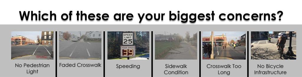
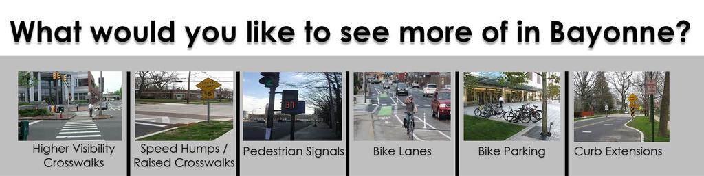
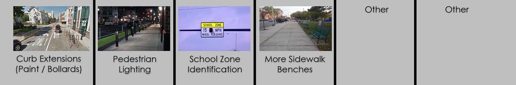
16 Visual Preference Board Activity Parents, students, and staff voted on their top priorities About 150 participants cast over 1,000 votes Eager to participate and share their concerns Other concerns were noted as well

17

18 What are your main concerns? Primary requests: 1. Lack of parking 2. Speeding 3. No pedestrian signal 4. Double parking
19


20 What do you want to see more of? Primary requests: 1. Pedestrian lighting 2. Crossing Bike lanes

21 Walkability Assessments


22 3. Wide driveway on West 11th between Avenue C and Broadway 4. Severe sidewalk damage at West 11th and JFK Bailey & All-Saints Walkability Assessment Wide driveway on West 12th at Avenue C 2. Severe sidewalk damage on West 12th and Broadway


23 Oresko & Vroom Walkability Assessment Long crosswalk, missing truncated dome, no pedestrian countdown signal. 2. Severe sidewalk damage Reverse bump encourages longer crosswalks, no pedestrian countdown signal. 4. Park in front of school missing sidewalk.


24 Lincoln Walkability Assessment Pedestrian-vehicular conflicts at E.29th street and Avenue E. 2. Potential for street furniture and pedestrian lighting on E.30th street. 3. Potential for Pedestrian signal at 30th street and Broadway/ Faded crosswalks. 4. Delineate driveways from sidewalks on E.29th street.


25 Lincoln Walkability Assessment 5. Makeshift bike parking on E.27th street adjacent to Lincoln School. 6. Potential for bicycle parking in front of Lincoln School Missing crosswalk and truncated dome on Prospect Ave. and E.27th street. 8. Kids play area at Ave.F and E.28th Street.


26 Lincoln Walkability Assessment Uneven sidewalk on E.32nd ramp - ADA noncompliance. 10. Speeding concerns on Route 440 / Long crosswalk, short ped. signal time. 11. Pedestrians walking along Route need protected walkways. 12. Missing curb cut / faded crosswalk on Prospect Avenue by 34th street station parking.

27 Speed Limits Along Route 440 Jurisdiction NJDOT Miles 4.04 m Source: NJDOT, July 2015

28 Low Stress Maps

29 Level of Traffic Stress (LTS)Methodology LTS Level Meaning 1 Typically suitable for those uncomfortable with cycling in traffic situations. 2 Can be tolerated by the mainstream American adult population. 3 Acceptable for an experienced, confident cyclist. 4 Only tolerated by the most adventurous of cyclists. Source: Mineta Transportation Institute, Report 11-19
 Map Graphic or large")
30 Level of Traffic Stress (LTS) Map Graphic or large photo
31 Level of Traffic Stress (LTS)Map Increase bicycle/pedestrian safety and circulation by improving traffic signals at key intersections, utilizing traffic calming measures and providing bike lanes that connect activity centers throughout the City. -Bayonne Master Plan

32 Action Steps
33 The 5 E s Engineering Enforcement Education Encouragement Evaluation Timeframe Definition Cost Definition Short-term = between 1 to 6 months Low = Less than $2,000 Mid-term = less than 1 year Medium = between $2,000 and $10,000 Long-term = between 1 to 5 years High = more than $10,000 Timeframes and Costs of Recommendations
34 ENGINEERING ACTION RESPONSIBLE AGENCY NEXT STEP TIMELINE COST Increase safety at W.29th street and Avenue E Pedestrian crossing. City Install pedestrian hybrid signals, reflective bollards and introduce new stop markings at the street intersection. Medium Low to Moderate Traffic calming measures on Route 440. State, City Introduce pedestrian refuges and create a protected pedestrian walkway along route 440. Medium- Long-term High Pedestrian countdown timers. City Install pedestrian countdown timers on all signalized intersections especially on Broadway and the Avenues. Medium - Long-term High Increase school zone identification and signage. City Increase school zone identification in and around all schools to increase awareness of pedestrian and bicyclists. Also install timed flashing school crossing signs. Short-term Low to Moderate Improve school bicycle parking facilities and explore opportunities for bicycle lanes. School district, City Create paved areas with covered bike parking that are secured and easily accessible. Also investigate opportunities for bicycle lanes. Medium Medium
35 ENFORCEMENT ACTION RESPONSIBLE AGENCY NEXT STEP TIMELINE COST Enhanced speed limit enforcement Police Dept. Prosecute speeders and dangerous drivers especially on the Avenues, JFK, and Broadway Enhanced enforcement of parking laws Police Dept. Ticket illegally parked vehicles, especially those that hinder pedestrian safety no parking near intersections, in crosswalks, on sidewalks, in front of hydrants, and driveways Discourage distracted driving Police Dept. Increase penalties for distracted drivers (i.e. use of cell phone while driving) More police officers on bicycles Police Dept. Integrate bicycle enforcement training into the police academy curriculum for new officers Ongoing Ongoing Ongoing Medium Low Low Low Low to Moderate
36 EDUCATION ACTION RESPONSIBLE AGENCY NEXT STEP TIMELINE COST Provide parents with information regarding driver and pedestrian safety within the school zone Police Dept., Schools, TMA Decide how to distribute material and what information is important to school zone Ongoing Low Work with Hudson TMA to develop and implement educational bicycle and pedestrian SRTS safety programing Schools, TMA, City Work with Hudson TMA to schedule programming in all schools Ongoing Low Create municipal websites and/or add to existing websites with the purpose of 1) providing anti-idling law education to parents and community members, and 2) spreading awareness of Stop and Stay Stopped law Schools, TMA, City Compile and organize information, and advertise website via and/or mail Short-term Low Provide parents with information regarding driver and pedestrian safety within the school zone Police Dept., Schools, TMA Decide how to distribute material and what information is important to school zone Ongoing Low
37 ENCOURAGEMENT ACTION RESPONSIBLE AGENCY NEXT STEP TIMELINE COST Schedule and participate in Walk to School Day in October and National Bike to School Day in May, as well as NJ Walk and Bike to school month each year. Schools, TMA Decide on the type of event, form a team, and pick a date Short-term Low Develop SRTS programs at all schools including student poster or art contests, walking mileage clubs, golden sneaker awards, etc. centered on walking and biking to school activities. Schools, TMA Decide on the type of event, form a team, and pick a date Short-term Low Install wayfinding signage NJDOT or City Identify intersections that could benefit from improved pedestrian-scale signage One-time Low to Moderate Host Bike/Walk to School Days throughout the school year Schools, TMA Decide on the type of event, form a team, and pick a date Short-term Low Work with Hudson TMA to develop walking School Bus program. PTAs, Schools, TMA Identify key partners in the community and begin gathering parties interested in participating. Ongoing Low Work with Hudson TMA to include pedestrian and bicycle safety information within school curriculum. Schools, TMA Provide ideas for teachers to lead lessons including a walk and bike-themed component. Short-term or ongoing Low
38 EVALUATION ACTION RESPONSIBLE AGENCY NEXT STEP TIMELINE COST Conduct speed analysis of targeted enforcement areas before and after enforcement City of Bayonne and Police Dept. Identify enforcement priority corridors Ongoing Low Create SRTS sub-committee to encourage and increase public involvement in SRTS programs Schools, School District Consider maintaining the School Travel Plan Working group as a SRTS committee Short-term Low Adopt a Complete Streets policy City Complete Streets include all ages and abilities Short-term Low to Moderate Monitor long-term crash data after road engineering improvements City of Bayonne or Police Dept. Identify key intersections and hot spots Ongoing Low
39 Recommendations

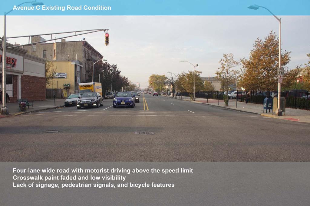
40 E.32nd Street and Route 440 Existing Conditions - Long crosswalks creating pedestrian safety concerns. - Illegible crosswalk markings. - Service pole minimizes pedestrian access on sidewalk.

41 Introduce pedestrian refuge. Introduce visible crosswalk markings. Introduce pedestrian push button. Relocate service pole or extend sidewalk. Remove right turn bay - right turns can be made on Prospect Ave.


42 E.29th Street and Avenue E Existing Conditions -Pedestrian vehicular conflicts. -Parking in no-parking zones.

43 E.29th Street and Avenue E Proposed Enhancements Introduce pedestrian hybrid signal (HAWK signal). Introduce stop bar road markings. Make no-parking zones more visible. Introduce reflective bollards. [Renderings not to scale]

44 E.24th Street and Gregg Lane Existing Conditions - Speeding concerns. - Missing curb cuts.
.")
45 Introduce raised crosswalk (speed hump). [Renderings not to scale]
46

47 [Renderings not to scale]
48

49 [Renderings not to scale]

50 E. 25th Street and Avenue E Existing Conditions - Reverse curb extension that creates a longer crosswalk - Missing truncated domes and faded crosswalks
51 E. 25th Street and Avenue E Proposed Improvements - Add curb extensions to shorten crosswalk lengths and improve visibility - Install high visibility crosswalks and truncated domes - Add stop bar and no parking zone 25 prior to crosswalks - Add pedestrian countdown signals on every corner
52 Questions?
53 Thank you!
Monument Elementary School Trenton, NJ School Travel Plan
 Monument Elementary School Trenton, NJ School Travel Plan Prepared by Greater Mercer TMA With Assistance from Alan M. Voorhees Transportation Center; Rutgers, The State University of New Jersey and NJ
SCHOOL NEIGHBORHOOD CHARACTERISTICS
 SECTION 4 SCHOOL NEIGHBORHOOD CHARACTERISTICS 28 04 SCHOOL NEIGHBORHOOD CHARACTERISTICS School Student Travel Mode Tally Summary Number of PM Trips Walk Bike School Bus Family Vehicle Carpool Public Transit
F L E T C H E R A V E N U E
 Jan. 29, 2014 Introduction F L E T C H E R A V E N U E FDOT Local Agency Program (LAP) Project FPN: 428214-1-58-01 CIP 63090 Hillsborough County, Traffic Engineering, PWD Stake holders and partners are
Hedgepeth Williams Middle School and Paul Robeson Elementary School Trenton, NJ. School Travel Plan
 Hedgepeth Williams Middle School and Paul Robeson Elementary School Trenton, NJ School Travel Plan Hedgepeth Williams Middle School Description: Hedgepeth-Williams Middle School is located at 301 Gladstone
Bridgewater Complete Streets Prioritization Plan and Pedestrian Safety Assessment
 Bridgewater Complete Streets Prioritization Plan and Pedestrian Safety Assessment Presented by Luciano Rabito Manager of Complete Streets Presented to Bridgewater, MA Wednesday, April 26, 2017 6:30 P.M.
Broad Street Bicycle Boulevard Design Guidelines
 Broad Street Bicycle Boulevard Design Guidelines Building from the strategies introduced in the 2013 Bicycle Transportation Plan and community input received thus far, City Transportation Staff have identified
California Department of Transportation, District 4. Sloat Boulevard Project Skyline Blvd. to 19 th Ave. Community Update January 13, 2016
 California Department of Transportation, District 4 Sloat Boulevard Project Skyline Blvd. to 19 th Ave. Community Update January 13, 2016 Agenda Welcome and introductions Project overview, history and
SAFE ROUTES TO SCHOOL (SR2S)
") SAFE ROUTES TO SCHOOL (SR2S) In partnership with Burbank Unified School District (BUSD) & City of Burbank George Washington Elementary School Thomas Jefferson Elementary School John Muir Middle School
SAFE ROUTES TO SCHOOL (SR2S) In partnership with Burbank Unified School District (BUSD) & City of Burbank George Washington Elementary School Thomas Jefferson Elementary School John Muir Middle School
Sebastopol Charter School Traffic Management Plan
 Sebastopol Charter School The serves as the working document in support of these essential goals: to ensure the safety and efficiency of student arrival to and departure from school to ensure the safety
WALKSacrame nto. Welcomes you to the 2009 Sacramento County Safe Routes to School Conference
 Sacramento County Department of Transportation Ron Vicari, Principal Civil Engineer In Partnership with: WALKSacrame nto Anne Geraghty, Terry Preston & Staff Welcomes you to the 2009 Sacramento County
Getting Your SRTS Project Funded. Ryan Snyder
 Getting Your SRTS Project Funded Ryan Snyder Steps in Submitting a Successful Application 1. Stakeholder outreach: create a SRTS coalition 2. Develop a comprehensive plan and program with all 5 Es 3. Conceive
North Avenue Corridor Study
 North Avenue Corridor Study Advisory Committee Meeting #6 July 1, 2014 Agenda Concept Revisions based on Advisory Committee feedback Review of New Concept Scoring & Costs Concept Discussion/Questions Voting:
Watertown Complete Streets Prioritization Plan. Public Meeting #1 December 14, 2017
 Watertown Complete Streets Prioritization Plan Public Meeting #1 December 14, 2017 Goals for Public Meeting Overview of MassDOT Complete Streets Funding Program Educate the community on Complete Streets
Woodrow Wilson Elementary School Trenton, NJ School Travel Plan
 Woodrow Wilson Elementary School Trenton, NJ School Travel Plan Prepared by Greater Mercer TMA With Assistance from Alan M. Voorhees Transportation Center; Rutgers, The State University of New Jersey and
City of Albert Lea Policy and Procedure Manual 4.10 ALBERT LEA CROSSWALK POLICY
 4.10 ALBERT LEA CROSSWALK POLICY PURPOSE: Pedestrian crosswalks are an integral part of our transportation infrastructure. To be effective and promote safety, marked crosswalks must be installed after
Bikeway action plan. Bicycle Friendly Community Workshop March 5, 2007 Rochester, MN
 Bikeway action plan Summary The was held on March 5, 2007 at the Rochester Mayo Civic Center. The workshop was hosted by Rochester-Olmsted County Planning Department in collaboration with the League of
Chicago Safe Routes to School Safe Routes to High School (SRTS/SRTHS)
") Chicago Safe Routes to School Safe Routes to High School (SRTS/SRTHS) Marshall Community High School and Faraday Elementary School Recommended Improvements Agenda Goals Related Programs Project Location/Area
Chicago Safe Routes to School Safe Routes to High School (SRTS/SRTHS) Marshall Community High School and Faraday Elementary School Recommended Improvements Agenda Goals Related Programs Project Location/Area
COWETA HIGH SCHOOL AND EAST HIGHWAY 51
 COWETA HIGH SCHOOL AND EAST HIGHWAY 51 Lack of sidewalks along Ben Lumpkin Rd. Lack of crosswalks and ramps at intersection. Hwy 51 is wide to cross as a pedestrian. No ADA compliance or connection to
5. RUNNINGWAY GUIDELINES
 5. RUNNINGWAY GUIDELINES These guidelines should be considered collectively when making runningway decisions. A runningway is the linear component of the transit system that forms the right-of-way reserved
Safe Routes to School Travel Plan 2011 Reading-Fleming Intermediate School (RFIS)
") Safe Routes to School Travel Plan 0 Reading-Fleming Intermediate School (RFIS) Reading Fleming Intermediate School 50 Court Street Flemington, NJ 088 Grades: 5-6 Introduction Reading-Fleming Intermediate
Safe Routes to School Travel Plan 0 Reading-Fleming Intermediate School (RFIS) Reading Fleming Intermediate School 50 Court Street Flemington, NJ 088 Grades: 5-6 Introduction Reading-Fleming Intermediate
Oakland Pedestrian Master Plan Oakland Pedestrian Plan Draft Recommendations Chapter Outline
 EISEN LETUNIC T R A N S P O R T A T I O N, ENVIRO N M E N TA L A N D URBAN PLANNIN G MEMORANDUM To Oakland Pedestrian Plan Technical Advisory Committee & Pedestrian Advisory Group From Victoria Eisen Date
C/CAG. Sunnybrae Elementary School Walking and Bicycling Audit. San Mateo-Foster City School District JUNE 2013
 Sunnybrae Elementary School Walking and Bicycling Audit JUNE 2013 San Mateo-Foster City School District C/CAG City/County Association of Governments of San Mateo County SUNNYBRAE ELEMENTARY SCHOOL WALKING
Bicycle Facilities Planning
 Bicycle Facilities Planning Overview Types of Cyclists Purpose for Riding Types of Facilities Bike Lanes Bicycle Boulevards Cycle Tracks Intersections Signals Signing and Marking Discussion Types of Bicyclists
EMPHASIS AREA 1: PEDESTRIANS
 EMPHASIS AREA 1: PEDESTRIANS A pedestrian is seriously injured or killed every 3 days on Toronto s roads. Pedestrian collisions involve any person that is not riding in a vehicle or on a bicycle. 26% OF
City of San Diego Vision Zero Draft Strategic Plan FY 2017
 City of San Diego Vision Zero Draft Strategic Plan FY 2017 Engineering Objective: To develop and implement a strategy that employs best planning, design and engineering practices. Background: Over the
CITY OF OAK CREEK SAFE ROUTES TO SCHOOL ACTION PLAN. East Middle School
 CITY OF OAK CREEK SAFE ROUTES TO SCHOOL ACTION PLAN East Middle School CITY OF OAK CREEK SAFE ROUTES TO SCHOOL ACTION PLAN East Middle School Why Safe Routes to School? Safe Routes to School ( SRTS ) is
Safe Routes to School Action Plan Aberdeen, Idaho
 Background Aberdeen, Idaho is a largely agricultural community of nearly 2,000 people and is located in the southeast portion of the state on the western edge of American Falls Reservoir. The community
City of Davis East Covell Corridor Plan
 Community Open House #2 January 22, 2014 6:00 8:00 p.m. Veterans Memorial Center, Club Room City of Davis Introduction The (ECCP) is a taking a comprehensive look at the existing transportation systems
What Is a Complete Street?
 Session 5 Charleen Zimmer, AICP, Zan Associates May 5-7, 2010 What Is a Complete Street? May 2010 5-1 Not a Complete Street More of a Complete Street May 2010 5-2 Benefits of Complete Streets Safety for
Traffic Improvements for the Transit Oriented Development District (TODD) Meriden Public Library March 11, 2014
 Meriden Public Library March 11, 2014") Traffic Improvements for the Transit Oriented Development District (TODD) Meriden Public Library March 11, 2014 Project Overview Coordinate roadway improvements with other major projects HUB Flood Control
Traffic Improvements for the Transit Oriented Development District (TODD) Meriden Public Library March 11, 2014 Project Overview Coordinate roadway improvements with other major projects HUB Flood Control
and older adults and people with disabilities still face barriers when using the pedestrian network and public transportation.
 Background Afterthe1980Olympics,theLakePlacid/NorthElbacommunityadoptedaneconomicstrategy ofdevelopingandmarketingeventstoincreaseareatourism.thisstrategyhasbeenvery successful.overrecentyearsthevolumeofvisitorshasincreased,andthelengthofthe
SRTS IMPLEMENTATION COSTS
 SRTS IMPLEMENTATION COSTS What Is a Estimate? A cost estimate establishes the anticipated budget required to implement the actions (the improvement projects and programs) identified in your School Travel
Montclair s Complete Streets Experience
 Presented by: Hon. Jerry Fried, Mayor Montclair Township About Montclair Six square miles Six commuter rail stations Four local bus routes (NJ Transit) Two private commuter bus routes Five business districts
FLETCHER AVENUE PEDESTRIAN AND BICYCLIST BEHAVIOR CHANGE FORMATIVE RESEARCH PROJECT
 FLETCHER AVENUE PEDESTRIAN AND BICYCLIST BEHAVIOR CHANGE FORMATIVE RESEARCH PROJECT EXTENT OF CHANGES IN PEDESTRIAN AND BICYCLIST ATTITUDES AND BEHAVIORS DIRECTLY AFTER A COMPLETE STREETS PROJECT IN FLORIDA
APPENDIX A: Complete Streets Checklist DRAFT NOVEMBER 2016
 APPENDIX A: Complete Streets Checklist DRAFT NOVEMBER 2016 Complete Streets Checklist MetroPlan Orlando s Complete Streets Checklist is an internal planning tool for staff to further implementation of
EXECUTIVE SUMMARY. Vision
 Vision Walking and bicycling in Salt Lake City will be safe, convenient, comfortable, and viable transportation options that connect people to places, foster recreational and economic development opportunities,
10.0 CURB EXTENSIONS GUIDELINE
 10.0 CURB EXTENSIONS GUIDELINE Road Engineering Design Guidelines Version 1.0 March 2017 City of Toronto, Transportation Services City of Toronto Page 0 Background In early 2014, Transportation Services
FLORIDA DEPARTMENT OF TRANSPORTATION DISTRICT 7 DISTRICT WIDE BICYCLE/PEDESTRIAN ACCESS TO TRANSIT SAFETY ASSESSMENT AND IMPROVEMENT PLAN
 FLORIDA DEPARTMENT OF TRANSPORTATION DISTRICT 7 DISTRICT WIDE BICYCLE/PEDESTRIAN ACCESS TO TRANSIT SAFETY ASSESSMENT AND IMPROVEMENT PLAN TRANSIT SAFETY ASSESSMENT SR 55/US 19 AT 80 TH AVE N DRAFT JUNE
Caltrans Sloat Boulevard Pedestrian Safety Project Response to Community Questions, Comments & Concerns
 Caltrans Sloat Boulevard Pedestrian Safety Project Response to Community Questions, Comments & Concerns Revised: May 10, 2016 The California Department of Transportation (Caltrans) is planning various
Cycle Track Design Best Practices Cycle Track Sections
 Design Best Practices Sections It is along street segments where the separation and protection methods of cycle tracks offer more comfort than conventional bicycle lanes, and are more attractive to a wide
Ottawa Beach Road Study
 Ottawa Beach Road Study Prepared For: Park Township September 30, 2014 Project No. G140303 OTTAWA BEACH ROAD STUDY PREPARED FOR: PARK TOWNSHIP SEPTEMBER 30, 2014 PROJECT NO. G140303 TABLE OF CONTENTS 1.0
Arlington s Master Transportation Plan
 Arlington s Master Transportation Plan The Master Transportation Plan (MTP) Adopted in eight parts Goals & Policies element and MTP Map adopted in 2007 Bicycle, Pedestrian and Demand and Systems Management
The DC Pedestrian Master Plan
 The DC Pedestrian Master Plan September 28, 2010 George Branyan Pedestrian Program Coordinator District Department of Transportation Presentation Agenda Scope of the Plan Methodology Recommendations Implementation
Non-Motorized Transportation 7-1
 Non-Motorized Transportation 7-1 Transportation facilities no longer mean just accommodating a vehicle powered by a combustion engine. Pedestrian and non-motorized facilities are important modes of travel
Lawrence Safe Routes to School. Community Meeting January 14, 2015
 Lawrence Safe Routes to School Community Meeting January 14, 2015 Safe Routes to School The 6 E s Education Encouragement Enforcement Engineering Evaluation Equity What are the elements of a SRTS plan?
Toward Zero Deaths. Regional SHSP Road Show Meeting. Virginia Strategic Highway Safety Plan. presented by
 Toward Zero Deaths Regional SHSP Road Show Meeting presented by Virginia Strategic Highway Safety Plan December 1, 2016 1 Welcome & Introductions Purpose of the Meeting Objectives & Key Outcomes Agenda»
Improvements Infrastructure Gap Assessment and Improvements Street Striping
 Infrastructure Project Proposal The federal-aid Safe Routes to School program funds infrastructure/engineering projects that fall into two categories: Design (available only to School Development Authority
AGENDA ITEM SUMMARY SPECIAL AGENDA ITEM NO. _1A_
 AGENDA ITEM SUMMARY AGENCY: City Council MEETING DATE: June 25, 2012 DEPARTMENT: Community Dev PREPARED BY: T Spade DEPT. DIR. APPROVAL: MJ CITY MGR. APPROVAL: LR PRESENTED BY: T Spade TITLE: RECEIVE REPORT
Sardis Elementary School Road Safety Plan. Produced by: Sardis Elementary School - Safer School Travel Team in cooperation with Safer City
 Sardis Elementary Road Safety Plan Produced by: Sardis Elementary - Safer Travel Team in cooperation with Safer City Plan completed in January 2016 1 Acknowledgements It takes commitment and community
Active Transportation Facility Glossary
 Active Transportation Facility Glossary This document defines different active transportation facilities and suggests appropriate corridor types. Click on a facility type to jump to its definition. Bike
Complete Streets. Designing Streets for Everyone. Sarnia
 Complete Streets Designing Streets for Everyone Sarnia Complete Streets ~ Sarnia ~ 2018 Introduction Our City is made up of a network of streets that we use to go for a walk, cycle to work, drive to the
Agenda. Overview PRINCE GEORGE S PLAZA METRO AREA PEDESTRIAN PLAN
 PRINCE GEORGE S PLAZA METRO AREA PEDESTRIAN PLAN May 28, 2008 Agenda Welcome and introductions Project overview and issue identification Planning context and strengths Design challenges and initial recommendations
Richmond-Adelaide Cycle Tracks
 Public Drop-In Event Richmond-Adelaide Cycle Tracks June 25, 2018 12:00 p.m. 3:00 p.m. 4:30 p.m. 7:30 p.m. Metro Hall, Rotunda 55 John Street 1 Purpose of Event In Scope Communicate an update about the
Appendix C 3. Bicycle / Pedestrian Planning
 Appendix C 3. Bicycle / Pedestrian Planning BICYCLE/PEDESTRIAN PLANNING 2005 Master Plan GOAL: Provide for safe and convenient bicycle and pedestrian circulation throughout the City. Develop a city-wide
Bringing together community and health. Physical Activity and Nutrition Unit Office of Statewide Health Improvement Initiatives
 Bringing together community and health. Physical Activity and Nutrition Unit Office of Statewide Health Improvement Initiatives Physical Activity and Nutrition Unit Office of Statewide Health Improvement
PRINCE GEORGE S PLAZA METRO AREA PEDESTRIAN PLAN
 PRINCE GEORGE S PLAZA METRO AREA PEDESTRIAN PLAN May 28, 2008 Agenda Welcome and introductions Project overview and issue identification Planning context and strengths Design challenges and initial recommendations
Chapter Four NON-INFRASTRUCTURE RECOMMENDATIONS. 5 E s. 5 E s. Education. Encouragement. Enforcement. Engineering. Evaluation
 Chapter Four NON-INFRASTRUCTURE RECOMMENDATIONS 5 E s The non-infrastructure recommendations in the Bicycle and Pedestrian Master Plan will help to foster a culture and environment that will help to increase
Doing it Right: Leveraging Data and Evaluation to Develop Pedestrian Safety Projects
 Doing it Right: Leveraging Data and Evaluation to Develop Pedestrian Safety Projects 1 Safe Kids Overview 2 Our Mission We work to keep all kids safe from preventable injuries 3 Why It Matters 4 Where
Tonight is for you. Learn everything you can. Share all your ideas.
 Strathcona Neighbourhood Renewal Draft Concept Design Tonight is for you. Learn everything you can. Share all your ideas. What is Neighbourhood Renewal? Creating a design with you for your neighbourhood.
Borough of Danville, PA Traffic Calming Program Guidelines
 Borough of Danville, PA Traffic Calming Program Guidelines Adopted by Borough Council on 1 INTRODUCTION Speeding Traffic is a major concern in the Borough of Danville because of its detrimental impacts
Chicago Safe Routes to High School (SRHS) Kelly High School Recommended Improvements
 Kelly High School Recommended Improvements") Chicago Safe Routes to High School (SRHS) Kelly High School Recommended Improvements March 18, 2014 Presentation Outline Goals Related Programs Project Location/Area Existing Conditions Improvement Types
Chicago Safe Routes to High School (SRHS) Kelly High School Recommended Improvements March 18, 2014 Presentation Outline Goals Related Programs Project Location/Area Existing Conditions Improvement Types
CAPITOL DRIVE & FOND DU LAC AVENUE INTERSECTION ANALYSIS. Urban Planning 772 SARAH BREGANT, RYAN PETERSON, & MATT WERDERITCH
 CAPITOL DRIVE & FOND DU LAC AVENUE INTERSECTION ANALYSIS Urban Planning 772 SARAH BREGANT, RYAN PETERSON, & MATT WERDERITCH OVERVIEW N 51 ST BOULEVARD N 51 ST BOULEVARD 12,100 44,700 W CAPITOL DRIVE 52,600
Wellington Exempted Village School District SAFE ROUTES TO SCHOOL TRAVEL PLAN January 2014
 Wellington Exempted Village School District SAFE ROUTES TO SCHOOL TRAVEL PLAN January 2014 OHIO SAFE ROUTES TO SCHOOL WELLINGTON EXEMPTED VILLAGE SCHOOL DISTRICT TRAVEL PLAN SECTION 1: WELLINGTON EXEMPTED
Rolling Out New Bike Facilities Within the North Bethesda & White Flint Area
 Rolling Out New Bike Facilities Within the North Bethesda & White Flint Area Rolling Out New Bike Facilities Within the North Bethesda & White Flint Area Agenda Designing for all Cyclists Background on
Leaside Traffic Calming Plan Update. Community Meeting 2 November 22, :00 PM
 Leaside Traffic Calming Plan Update Community Meeting 2 November 22, 2016 7:00 PM Welcome and Study Background Welcome and Thank You! Study background from LPOA s perspective: Why are we doing this study?
MEMORANDUM. Discussion of the planned crosswalk improvement on Mount Vernon Road near Stratham Drive
 MEMORANDUM To: From: Mayor and City Council Michael Smith, Public Works Director Date: August 24, 2015 Subject: Discussion of the Mount Vernon Road Crosswalk Improvement ITEM DESCRIPTION Discussion of
Enhanced Walkabout Summary Report
 Enhanced Walkabout Summary Report Introduction On September 18, 2013, thirteen participants met at Galax Elementary School in Galax, Virginia to examine the walking and bicycling network around the elementary
Complete Streets Chicago: Data Driven Design. Luann Hamilton Deputy Commissioner
 Complete Streets Chicago: Data Driven Design Luann Hamilton Deputy Commissioner AGENDA Chicago s goals Complete Streets & Sustainable Infrastructure Guides Data-Driven Planning Setting goals Scoping/research
Frequently Asked Questions
 Frequently Asked Questions Business US 190 in Copperas Cove From Avenue D to Constitution Drive What is access management? A. Access Management is a growing effort by government agencies to improve how
El Camino Real Specific Plan. TAC/CAC Meeting #2 Aug 1, 2018
 El Camino Real Specific Plan TAC/CAC Meeting #2 Aug 1, 2018 Land Use Alternatives Goals and Tradeoffs Parks & open space Housing Retail & services Civic spaces Parking Community gathering spaces 3 Alternatives
Safe Routes to School: Munroe Elementary Walk Audit Report. Image: Drexel, Barrell & Co.
 Safe Routes to School: Munroe Elementary Walk Audit Report Image: Drexel, Barrell & Co. April 12, 2016 OVERVIEW As part of the 2014/2015 Denver Safe Routes to School (SRTS) Program, WalkDenver coordinated
Mission-Geneva Transportation Study Community Workshop 2 July 8, 2006
 Community Workshop 2 July 8, 2006 Small Group Workbook 1 Basic Improvements on Mission Street Streetscape. Pedestrian-scale lighting; landscaping; community art on utility boxes; more (possibly unique)
CITY OF OTTAWA ROADWAY MODIFICATION APPROVAL UNDER DELEGATED AUTHORITY
 RMA-2015-ATM-038 CITY OF OTTAWA ROADWAY MODIFICATION APPROVAL UNDER DELEGATED AUTHORITY DATE: April 22, 2015 SUBJECT Approval of Roadway Modifications Recommended through an Area Traffic Management Study
Complete Streets: Planning, Policy & Performance
 Complete Streets: Planning, Policy & Performance Tell Us About Your CS Experiences Successes Hardships Funding Politics Safety Not every street needs to be complete, but every mode needs a complete network.
CHILLICOTHE CITY SCHOOLS. SAFE ROUTES TO SCHOOL TRAVEL PLANS for Allen, Mt. Logan, Tiffin & Worthington Elementary Schools January 2013
 CHILLICOTHE CITY SCHOOLS SAFE ROUTES TO SCHOOL TRAVEL PLANS for Allen, Mt. Logan, Tiffin & Worthington Elementary Schools January 2013 i Ohio s Safe Routes to School Travel Plan Template www.dot.state.oh.us/saferoutes
Overview. Illinois Bike Summit IDOT Complete Streets Policy Presentation. What is a Complete Street? And why build them? And why build them?
 Overview Illinois Bike Summit IDOT Complete Streets Policy Presentation Aren Kriks, P.E. District One Bicycle Coordinator and Bureau of Programming Project Engineer History of Complete Streets IDOT Policy
CITY OF COCOA BEACH 2025 COMPREHENSIVE PLAN. Section VIII Mobility Element Goals, Objectives, and Policies
 CITY OF COCOA BEACH 2025 COMPREHENSIVE PLAN Section VIII Mobility Element Goals, Objectives, and Policies Adopted August 6, 2015 by Ordinance No. 1591 VIII MOBILITY ELEMENT Table of Contents Page Number
TRAFFIC CALMING POLICY & PROCEDURES
 TRAFFIC CALMING POLICY & PROCEDURES AS ADOPTED BY MONTCLAIR TOWNSHIP COUNCIL AUGUST 4, 2009 TABLE OF CONTENTS 1. INTRODUCTION... 2 Purpose... 2 Traffic Calming Definition... 2 Statement Of Township Council
2018 Pedestrian and Bicycle and Safe Routes to School Application for Funding Page 1 of 31
 2018 Pedestrian and Bicycle and Safe Routes to School Application for Funding Page 1 of 31 2018 Pedestrian and Bicycle and Safe Routes to School Application for Funding Part 1: General Information Funding
Implementing the Three Es of School Zone Traffic Calming
 Implementing the Three Es of School Zone Traffic Calming Use this evaluation tool as a guide to analyze the specific safety needs of your school. SCHOOL PROFILE School Name: School District: Address: Phone
PROSPECT ELEMENTARY GIRARD INTERMEDIATE GIRARD JUNIOR HIGH
 PROSPECT ELEMENTARY GIRARD INTERMEDIATE GIRARD JUNIOR HIGH SAFE ROUTES TO SCHOOL SCHOOL TRAVEL PLAN January 8, 2014 2 SECTION 1: OUR SCHOOLS School District School Name School Address Grades served Girard
2014/2015 BIKE ROUTE PLAN 83 AVENUE PROTECTED BIKE LANE
 About the Project The City of Edmonton is planning a major bike route on the southside of Edmonton. The Strathcona Bike Route will connect the communities of Strathcona, Garneau and the University area,
SAFE ROUTES TO SCHOOL
 SAFE ROUTES TO SCHOOL Edgewood Elementary School Existing Conditions and ACTION PLAN > Oak Creek - Franklin Joint School District Table of Contents CONTEXT Enrollment Boundaries Enrollment
Rim Rock Elementary School Walking and Biking Audit
 Rim Rock Elementary School Walking and Biking Audit September 29, 2016 Rim Rock Elementary School Audit for Walking and Biking September 29, 2016 Audit Team Members: Sam Atkins, City Engineer, City of
BEVERLY GARDENS ELEMENTARY SCHOOL TRAVEL PLAN
 BEVERLY GARDENS ELEMENTARY SCHOOL TRAVEL PLAN City of Riverside, Ohio Ohio Safe Routes to School Plan INDEX SECTION 1: TARGET SCHOOLS AND THE SAFE ROUTES TO SCHOOL TEAM SECTION 2: INTRODUCTION SECTION
SAFE ROUTES TO SCHOOL
 SAFE ROUTES TO SCHOOL Forest Ridge Elementary School Existing Conditions and ACTION PLAN > Oak Creek - Franklin Joint School District Table of Contents CONTEXT Enrollment Boundaries
PROJECT OVERVIEW. 20th Avenue Project Limits (Lincoln Way to Wawona St)
") PROJECT OVERVIEW In 2014, San Francisco adopted Vision Zero as City policy, with a commitment to eliminate all traffic deaths in the City by 2024. nue Project Limits (Lincoln Way to St) Collision data
PROJECT OVERVIEW In 2014, San Francisco adopted Vision Zero as City policy, with a commitment to eliminate all traffic deaths in the City by 2024. nue Project Limits (Lincoln Way to St) Collision data
TRAFFIC CALMING GUIDE FOR TORONTO CITY OF TORONTO TRANSPORTATION SERVICES DIVISION
 TRAFFIC CALMING GUIDE FOR TORONTO CITY OF TORONTO TRANSPORTATION SERVICES DIVISION CITY OF TORONTO TRANSPORTATION SERVICES DIVISION 2016 TRAFFIC CALMING GUIDE FOR TORONTO TABLE OF CONTENTS Introduction
Memorandum. Public Comments
 711 SE Grand Ave. Portland, OR 97214 (503) 230-9862 www.altaplanning.com Memorandum Date: November 30, 2016 To: From: Re: City of Tacoma Hannah Day-Kapell and Gena Gastaldi, Alta Planning + Design Tacoma
TRAFFIC IMPACT ANALYSIS
 TRAFFIC IMPACT ANALYSIS FOR THE CHAMPAIGN UNIT#4 SCHOOL DISTRICT PROPOSED HIGH SCHOOL (SPALDING PARK SITE) IN THE CITY OF CHAMPAIGN Final Report Champaign Urbana Urbanized Area Transportation Study 6/24/2014
MONTCLAIR SAFE COMPLETE STREETS IMPLEMENTATION PLAN. Monday November 13, 2017 Michael Dannemiller, Principal Engineer NV5, Inc.
 MONTCLAIR SAFE COMPLETE STREETS IMPLEMENTATION PLAN Monday November 13, 2017 Michael Dannemiller, Principal Engineer NV5, Inc. PROJECT TEAM THE OFFICE OF BICYCLE AND PEDESTRIAN PROGRAMS, NEW JERSEY DEPARTMENT
Arlington Public Schools New Elementary School at Thomas Jefferson Site Off-Site Transportation. Thomas Jefferson BLPC / PFRC Meeting July 27, 2016
 Arlington Public Schools New Elementary School at Thomas Jefferson Site Off-Site Transportation Thomas Jefferson BLPC / PFRC Meeting July 27, 2016 1.Review of Analysis 2.Key Transportation Issues 3.Recommendations
Commerce Street Complete Street Project from Good Latimer Expressway to Exposition Avenue
 Commerce Street Complete Street Project from Good Latimer Expressway to Exposition Avenue T A N Y A B R O O K S A S S I S T A N T D I R E C T O R M O B I L I T Y P L A N N I N G M O B I L I T Y A N D S
City of Ann Arbor Pedestrian Safety & Access Task Force
 City of Ann Arbor Pedestrian Safety & Access Task Force Community Wide Meeting #2 Wednesday, March 25 th 6:30 to 8:30 PM Multi-purpose Room, Downtown Library The Greenway Collaborative, Inc. www.greenwaycollab.com
HYATTSVILLE TRANSPORTATION PLAN. City Council Update March 19, 2018
 HYATTSVILLE TRANSPORTATION PLAN City Council Update March 19, 2018 AGENDA PROJECT GOALS DATA COLLECTION WHAT WE LEARNED NEXT STEPS PROJECT GOALS Identify bicycle and pedestrian needs of the city Evaluate
COMPLETE STREETS FUNDING PROGRAM
 COMPLETE STREETS FUNDING PROGRAM Prepared by: MassDOT Highway Division & Office of Transportation Planning Leading the Na 1 Complete Streets Funding Program 1. Background Complete Streets Defined Complete
City of Vineland Safe Routes to School Travel Plan
 April 1, 2014 2014 City of Vineland Safe Routes to School Travel Plan Gloria M. Sabater Elementary School 4/1/2014 Contents Introduction 1 School Description 1 Existing Policies and Practices 2 Walk/Bike
20 th Avenue Neighborway Project August 2, Second Open House
 20 th Avenue Neighborway Project August 2, 2018 - Second Open House General Comments We love the plan in general and appreciate the SFMTA looking out for walkers and bikers. Can we get better traffic enforcement
North Berwyn School District 98 School Travel Plan
 North Berwyn District 98 Travel Plan North Berwyn District 98 Travel Plan Presented by Active Transportation Alliance February 2012 Acknowledgements North Berwyn District 98 Wellness Committee This plan
WELCOME. Thank you for joining us at the Second Public Workshop for the Carlsbad Pedestrian Master Plan. We look forward to receiving your feedback.
 City of Carlsbad Pedestrian Master Plan: WELCOME WELCOME Please Sign In Provide Input at Flip Charts Review Boards Presentation of Draft Plan Thank you for joining us at the Second Public Workshop for